Introduction
Between 1746 and 1792 Carl Linnaeus sent 17 of his more talented young students, fondly known as the Linnaean apostles, on voyages around the world. Their assignment was to describe and collect specimens of the local flora, fauna and mineral kingdom. The travellers were also to record in their note books information about regions, peoples and their customs but not least, enterprises that could benefit the Swedish economy (Hansen, Reference Hansen2007–Reference Hansen2011; Sörlin & Fagerstedt, Reference Sörlin and Fagerstedt2004). The voyages were not without risks—half of the students would pay the ultimate price in this quest for knowledge. One of the least known of these students was Anton Rolandson Martin (1729–1786). He was born in Estonia but received his basic education in Åbo (Turku), Finland, both countries being part of the Kingdom of Sweden at the time. Martin studied music, physics, poetry and languages, one of which was Dutch, which would become very useful later. In 1750 his interest turned to botany, which he studied under the guidance of Professor Johan Leche at the Royal Academy in Åbo. Three years later he travelled to Stockholm, Sweden, ‘to seek his fortune’ (text translated from Swedish) and spent some years there working as a tutor (Martin, Reference Martin, Jemn, Broberg and Dunér2009, pp. 85–86). After presenting a few essays to the Royal Academy of Sciences he was accepted as a disciple. In the autumn of 1756, aged 26, he enrolled at the University of Uppsala. Here he met Linnaeus, who became impressed by this poor and peculiar ‘Finn’ (Jemn, Reference Jemn and Rickberg2008). (For more of Martin's biography see Nordström (Reference Nordström1881) and Martin (Reference Martin, Jemn, Broberg and Dunér2009)).
The offer to go to the Arctic
In 1758 Linnaeus suggested that Martin should travel with a whaler ‘to the North Pole and there collect specimens of nature’ (Martin, Reference Martin, Jemn, Broberg and Dunér2009, p. 89). His application for a travel grant from the Royal Academy of Sciences was approved and instructions were issued.
The ship, an ice strengthened hooker named De Visser (The Fisherman), had a mixed Dutch and Swedish crew, but was owned by the Swedish, Gothenburg-based, Greenland Company. The commander of the ship was a Dutchman, Jan Dircks Claessen. This was his 15th or 16th journey to the Arctic (Martin, Reference Martin1881). The company had organised whaling expeditions to the hunting grounds west of Spitsbergen in the three preceding years (Awebro, Reference Awebro1996). At this time the Swedish fishermen had just started to leave their coastal waters and venture out on the high seas to hunt for fish and marine mammals. It was a member of the Greenland Company, Pehr Samuel Bagge, who had offered Linnaeus a place for a naturalist, with free food and lodging, on this voyage as part of his wish to promote science. Bagge also arranged for Martin to borrow a thermometer, an azimuth compass and a quadrant. The ship departed Gothenburg on 17 April 1758.
The voyage
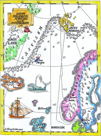
In Martin's travel account he gives some geographical information on the lands they passed and the occurrence of large ice fields. This provides some hints to the ship's position on certain dates (Martin, Reference Martin1881). However, the most important information comes from his meteorological records (Martin, Reference Martin1758). During the whole voyage Martin made systematic weather observations. Three times a day—at six o'clock in the morning, at noon and at midnight—he read the temperature from his thermometer, which hung in the shade on deck. Martin also recorded the dominating wind direction and weather for the day. Being a sailing ship it is warranted to assume that De Visser sailed in the general direction of the wind as it patrolled the hunting grounds between Spitsbergen and Greenland. The approximate daily latitude was also given to the accuracy of a quarter of a degree. This was traditionally done by measuring the sun's height above the horizon at noon (Cotter, Reference Cotter1983). No other celestial bodies could be used for this task as the sun stayed above the horizon all day from 5 May and the stars faded away. Although Martin had his own quadrant, it is most likely that the latitude was determined by the crew. This is suggested by the fact that on many occasions the comparatively easy task of reading Martin's thermometer at noon was not performed, whereas the more demanding task of determining the sun's height above the horizon on a rolling ship was. On these midday occasions Martin probably stayed below deck for some reason. That the crew performed the task of determining the latitude is also suggested by the importance of remaining between 78 and 79°N, which was believed to be the best position to encounter bowhead whales (Martin, Reference Martin1881). By compiling the above data, a probable route of the ship can be determined (Fig. 1).
The likely route of the whaler De Visser on its voyage to the waters west of Spitsbergen, 17 April–24 July 1758. Geographical names are spelled as Martin did at the time.

After rounding southern Norway on their outbound journey, the ship approached the coast in the area of Trondheim on 23 April 1758, probably as a way to determine their east–west position before heading due north. At this point in time there was no simple and reliable method to determine longitude (Sobel, Reference Sobel1995). The Swedish ship was accompanied by other western European whalers. In 1758, more than 200 ships from British, Dutch, German and Danish ports headed north. In addition, some 20 sealers joined the armada (Martin, Reference Martin1881). Two weeks later the first ice was spotted, and the ship reached the latitude of Spitsbergen at 76.5°N in the second week of May. After sailing along the coast in the vicinity of Prins Karls Forland, on 12 May they sailed westwards by easterly winds. It was believed that the best chance of encountering bowhead whales was in the ice to the west—as the saying went:
West ice, best ice (Martin, Reference Martin1881, p. 103).
Västisen (the west ice) consists of masses of ice transported from the Arctic Ocean southwest along the east coast of Greenland. The eastern margin of this densely packed ice is usually situated somewhere halfway between Greenland and Spitsbergen (Norwegian Ice Service, MET Norway, http://polarview.met.no/, accessed 18 May 2016). The exact east–west position of the ship is uncertain, as it depends on where the eastern edge of the ice was situated during the month De Visser cruised these waters. On 17 May the ship battled a south–southeasterly storm surrounded by heavy ice. Martin lived through this ordeal, in his bed clasping his hymn book (Martin, Reference Martin, Jemn, Broberg and Dunér2009). They were later to be told that 11 whalers were lost with all hands in the same storm. De Visser had been driven north and now turned back south and moored at an ice floe. Here the crew killed a hooded seal (Cystophora cristata), which Martin studied (Martin, Reference Martin1881). A Dutch whaler moored nearby on 5 June. It had a bowhead whale (Balaena mysticetus) in tow. Martin walked across the ice to the ship and saw enough of the animal to give a detailed description (Martin, Reference Martin1881). He also wrote down how the Dutch organised life on-board and the techniques used when catching whales. On 7 June they got stuck in the ice and remained there until 11 June when westerly winds freed them, only to be surrounded by ice again three days later, this time due to a storm from the northeast. A week-long imprisonment was lifted after two days of hard work with boathooks and towing. In response to the densely packed ice and the fact that no birds—which were considered to accompany whales—could be seen, the crew decided to head back to Spitsbergen to refill their fresh water stores. On 23–24 June the ship reached the coast of mainland Spitsbergen and sailed north in snowy conditions, passing 78°N. Southerly winds on 24–25 June carried them further north and they passed Prins Karls Forland, some 40 km distant to the east. Along the coast the crew spotted fin whales (Balaenoptera physalus). This was considered a bad sign that indicated that the bowhead whale hunting season was nearing its end. Travelling further north they saw the seven glaciers on the coast of Albert I Land and on 27 June they sailed past Hakluythovden, the northern point of Amsterdamøya. An attempt to enter ‘Nordbay’, the northern part of Smeerenbugfjorden, east of the island, had to be abandoned because the inlet was filled with ice (Martin, Reference Martin1881). The previous year the ship had replenished its fresh water stores here (Awebro, Reference Awebro1996). Martin writes in his account that this year was unusually cold, with abundant ice and snow (Martin, Reference Martin1758). This is corroborated by observations from northern Iceland, which show that the 1750s was a very cold decade (Ogilvie, Reference Ogilvie1984). According to Martin, the ship continued to 80°N, the most northerly position of the journey, where on 28 July they saw partly ice-free waters north of Spitsbergen (Martin, Reference Martin1881). After turning south the ship joined other whalers outside Krossfjorden and Kongsfjorden but again heavy ice prevented entry to these harbours. Finally, on 1 July Martin, together with some of the crew, managed to set foot on land in a group of small islands. The identity of these islets has never been positively confirmed. In an effort to remedy this here, Martin's texts are scrutinised for clues.
Identifying the landing place
In Martin's own words the islets were situated ‘not far from Forland’ (Martin, Reference Martin1881, p. 130). However, this could not be uncritically taken to mean the island Prins Karls Forland. At the time the whole west coast of Spitsbergen, where whaling took place, could be referred to as ‘Voorland’ (Orheim & Hoel, Reference Orheim and Hoel2003). Martin states that the ‘Vorland Island’ is 50 miles long—equivalent to 535 km (an old Swedish mile is 10.7 km). The correct length of the island is 86 km. His unspecific use of the name is further shown when he places ‘The Seven Glaciers’ at ‘Medelhok af Vorland’. They are in reality situated 50 km north of Prins Karls Forland on mainland Spitsbergen.
By studying aerial photographs of northwestern Spitsbergen (Toposvalbard, Norsk Polarinstitutt, http://toposvalbard.npolar.no/, accessed 20 September 2015) one candidate for the islets matching Martin's descriptions stands out—Forlandsøyane, at 78°20.4ʹN, 11°36ʹE. The group sits off the southwestern part of Prins Karls Forland and consists of three islets. The middle one, Midtøya, is the biggest at 35 ha—double the size of Nordøya to the north and nine times the size of Sørøya to the south. Midtøya and Nordøya were probably the islands that the crew would have been aiming for. There are also beaches suitable for landing on the two islets. According to Martin, two sloops were used, which generally had a crew of five each (Martin, Reference Martin1758). With Martin this gives a total of 11 men—but there was probably room for a few more of the ship's crew. The reason for the landing was to get fresh food by collecting eggs and shooting some ducks (common eider, Somateria mollissima). One and a half barrels of eider down were also collected, probably in order to make some profit on this hitherto unsuccessful whaling voyage. In his travel account Martin also writes that the islets ‘. . . lay [a] couple of miles from the mainland’ (Martin, Reference Martin1758, p. 313). This fits with the mountains of mainland Spitsbergen to the east, which are visible across the lowlands of Prins Karls Forland at a distance of 25 km.
Martin collected several specimens of marine and terrestrial plants and animals, as well as rock samples. Only one item was generally thought to have survived—a specimen of Greenland scurvy grass Cochlearia groenlandica, which is today kept in the collections of the Swedish Museum of Natural History. On the herbarium sheet is written:
Lecta in insula /. Vogel – eyland:/ prope Spitsbergen. 1758. Martin (Translation: Collected on the island/ Bird Island/ near Spitsbergen. 1758. Martin).
The Dutch name of the island implies that birds were common here. Martin writes that eiders in the thousands flocked on the island despite the extensive snow cover (Martin, Reference Martin1881). Today the islets are a bird sanctuary, partly because of the great number of eiders nesting there (Vongraven, Reference Vongraven2014). These islands must have been well known to the Dutch part of the crew, as islands at this position have been marked on Dutch maps at least from the time of Joris Carolus in 1614 (Carolus, Reference Carolus1614).
Based on Martin's description alone, Mehlum (Reference Mehlum2014) also came to the conclusion that these islets are the probable candidates for the landing.
The breakthrough in the attempt to positively identify the islets came when I was made aware by a colleague at the Swedish Museum of Natural History of a rock specimen collected by Martin on the islets. The specimen was identified by Zenzén (Reference Zenzén1920) based on information in Martin's diary where he describes the specimen, which on his return to Sweden he donated to the Bergskollegii collections, today a part of the Swedish Museum of Natural History collection in Stockholm. Zenzén's discovery has been almost totally forgotten, resulting in this specimen not being mentioned in later publications on Martin (Jemn, Reference Jemn and Rickberg2008; Mehlum, Reference Mehlum2014). The specimen is quartzitic sandstone with thin intercalations of dark grey phyllite and dotted with small pyrite cubes. The southern part of Prins Karls Forland consists of Neoproterozoic rocks (650–540 million years old), including quartz–carbonate–mica rocks, phyllite and quartzite (Dallmann, Reference Dallmann2015). This rock sample became the key to positively confirming the landing place.
The landing
At noon on 1 July, De Visser sailed at latitude 79.5°N, still some 140 km north–northwest of the presumed landing place at Forlandsøyane. Was it possible to cover this distance during the remaining 12 hours of that day? There is no information in the texts on the speed of De Visser. However, on 22–23 April the ship had sailed north in the Norwegian Sea under favourable winds (east–southeast to south–southwest) and during 24 hours the vessel crossed two latitudes. This was repeated on 9–10 July when returning south under a north–easterly wind. The distance between two latitudes is 222 km, giving the ship a speed of about five knots. This figure only gives a hint of the speed of De Visser travelling downwind, as the strength of the wind was never recorded in Martin's meteorological journal.
The two days preceding Martin's landing had seen south–easterly winds, which should have cleared the coastal waters of dangerous ice floes, allowing for easy sailing. Assuming the speed was around five knots, the ship could have reached the islets by late evening on 1 July or the early hours on 2 July.
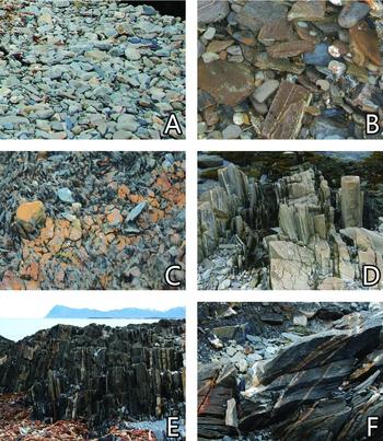
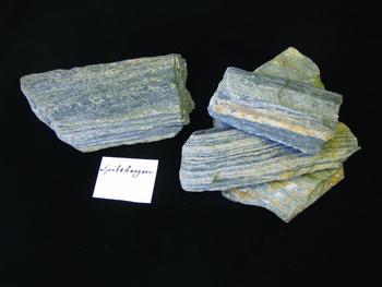
The visit ashore was short, as Martin and the crew were forced back to the ship after just two hours as an increasing northwesterly wind threatened their safety. I spent the same amount of time on Midtøya in the early morning of 10 September 2016; this visit was cut short by increasing swell making the transfers between the zodiacs and the expedition ship dangerous. There was, however, enough time to collect rock samples on Midtøya's western shores identical to Martin's specimen and to confirm his observations of the local geology (Figs 2 & 3). It was too late in the season to make new collections of the plant and animal life that Martin recorded in early July, as I was met with a rather lifeless island on the September expedition. However, the geological confirmation means that Martin's landing place is hereby positively identified.
Martin's notations (1881: 130–131) illustrated by recent photos taken on Forlandsøyane. A. ‘Quartz pebbles were of 2 kinds, all white and all grey. . .’ B. ‘. . .in one place on the shore were brown and red sandstones stacked. . .’ C. ‘Where the sea acted upon the shale outcrops they were rust coloured. . .’ D. ‘Some grey stone outcrops looked rather peculiar, which consisted of oblong pieces, which rose perpendicular aloft, and between them lay lower parallel sheets of shale vertically. . .’ E. ‘The shores on these islets were black from a weathered shale that all the rock outcrops here mostly consist of.’ F. ‘Occasionally one saw some quartz veins parallel with the horizon.’ (Photographs: H. Jorikson, J. Hagström and U. Johansson).

Martin's rock sample from 1758 (left) and specimens collected in September 2016 on Midtøya (right). (Photograph: J. Hagström).

Although Martin seems to identify himself with the crew, as he often uses the word ‘we’ in his diary, it is evident there was an underlying conflict between the interests of the crew and the naturalist. If the hunting failed, which it did, it would mean that the harpooners would not make any money out of this voyage (Martin, Reference Martin1881). Martin on the other hand was eager to get ashore to see ‘something remarkable’ (Martin, Reference Martin1881, p. 130). The landing on Forlandsøyane was brought about by a need for fresh provisions and collecting of eider down—not to please the scientist. At the end of June Martin had tried in vain to get the ship to enter Magdalenefjorden, and at the short landing at Forlandsöyane Martin had asked the captain to stay in the area for a couple of days, which he seemed to agree to, but
. . . he appears to have had additional advisors for before I knew it the sails were turned and we set the course homeward (Martin, Reference Martin, Jemn, Broberg and Dunér2009, p. 90).
After Martin's landing, northerly winds took the ship south. An unsuccessful attempt to approach land to hunt for walruses on 3 July marked their final attempt to catch what they came for, and they left Spitsbergen on 4 July—so not to cause the company further losses. After stopping for some fishing in the North Sea they reached Gothenburg on 24 July.
Legacy
Martin's voyage to the Arctic has been unfairly forgotten. His report is good in the light of him having been confined to the ship for almost the entire three-month journey. Nevertheless, he described several animals—from small crustaceans to whales. He performed meteorological observations and recorded atmospheric phenomena. He made enquiries into the magnetic declination at these high latitudes. The various types of ice and snow were described. The water temperature was determined—even down to a depth of 14 m. During his brief landing he sampled and described the local flora, fauna and geology. How the work was organised on-board the ship is reported, with an emphasis on how to hunt for and process whales. Martin himself was especially proud of three things accomplished during the voyage—his recording of the climate at ‘the North Pole’, his push for Swedish whaling in these waters and his revelation of God's wonders, even here at the ‘most miserable’ of places. His employer Linnaeus was also satisfied and would have offered him the opportunity to repeat the expedition the following season had Martin not gone on a year-long journey to Norway instead. Not long after his return from this voyage he lost his right leg to gangrene at the age of 33. Martin gave up on his medical studies he had started in Uppsala. The reason was probably failing health due to tuberculosis and asthma. When he was also unable to secure a position as a teacher, Martin chose to return to Finland. For the rest of his life he lived off a pension from the Royal Academy of Sciences and by working as a tutor. Several scientific works by Martin were sent to the Academy, some of which were published (Nordström, Reference Nordström1881). In his autobiography of 1762 he wrote:
I want to live like an old and honest student in all my days and use my time, not idly for my own amusement, [but] in stillness look upon my fate and with my modest knowledge do service to the Sciences, to my ability (Martin, Reference Martin, Jemn, Broberg and Dunér2009, p. 113).
He died unmarried and childless in 1786 at the age of 56.
Acknowledgements
I thank the IK Foundation for organising, and being part of, ‘The Bridge Builder Expeditions Spitsbergen’. Field work is one of the undertakings IK uses in its quest to promote understanding of our natural and cultural history and to continue to build on the achievements of the Linnaean apostles, which has long been a mission within the organisation (for more information about this NGO and its work please visit www.ikfoundation.org). My sincere thanks go to Jörgen Langhof of the Swedish Museum, of Natural History for making me aware of Martin's rock specimen. For patient assistance regarding latitude determinations: Diederick Wildeman, National Maritime Museum, Amsterdam; Karl Grandin and Jonas Häggblom, Royal Academy of Sciences; and Manne Dunge, Swedish National Maritime Museums. For help with the geology of Prins Karls Forland, I thank Winfried Dallmann, University of Tromsø, and Jaroslaw Majka, Uppsala University. For correction of the language I thank Sam Slater. I thank the two anonymous reviewers whose suggestions helped improve and clarify this manuscript.