

INTRODUCTION
The Indonesian archipelago encompasses 5.8 million square kilometres of coastal and oceanic waters within the Coral Triangle (Coral Triangle Initiative, 2009). While well known for coral and reef fish diversity, Indonesia also hosts 31 species of cetaceans (Rudolf et al., Reference Rudolf, Smeenk and Leatherwood1997; Tomascik et al., Reference Tomascik, Mah, Nontji, Moosa, Tomascik, Mah, Nontji and Moosa1997). Within Indonesia, the Bird's Head Seascape (BHS) has the highest near-shore marine diversity (Veron et al., Reference Veron, DeVantier, Turak, Green, Kininmonth, Stafford-Smith and Peterson2009; Allen & Erdmann, Reference Allen and Erdmann2012) and is a national priority for conservation (Huffard et al., Reference Huffard, Erdmann and Gunawan2009). There are unpublished studies and anecdotal evidence which indicate that the BHS also provides critical habitat for a number of large, endangered marine species such as whales, dolphins, sea turtles and dugong, especially in the waters of Raja Ampat (see review in Mangubhai et al., Reference Mangubhai, Erdmann, Wilson, Huffard, Ballamu, Hidayat, Hitipeuw, Lazuardi, Pada, Purba, Rotinsulu, Rumetna, Sumolang and Wen2012).
Indonesia was a popular whaling ground for sperm whales in the 19th Century (Rudolf et al., Reference Rudolf, Smeenk and Leatherwood1997). With the exception of traditional hunting in two villages in Solor, East Nusa Tenggara (Barnes, Reference Barnes1996), cetaceans are now protected from harvesting in Indonesian waters. Cetaceans however, face increasing threats and stressors from ship strikes, entanglement in fishing nets, and noise and plastic pollution (Mangubhai et al., Reference Mangubhai, Erdmann, Wilson, Huffard, Ballamu, Hidayat, Hitipeuw, Lazuardi, Pada, Purba, Rotinsulu, Rumetna, Sumolang and Wen2012). To date, marine conservation efforts in Raja Ampat include the establishment of a network of seven marine protected areas (MPAs) encompassing over 1 million hectares of coastal and oceanic habitats, designation of the region as a maritime Regency, and a ban on the hunting and killing of all large marine fauna. However, MPAs were designed predominantly for protection of coastal habitats and to support sustainable local fisheries, and therefore may not be the most effective management tool for large, highly mobile cetaceans in their current configuration. Information on cetacean species, their behaviour and their spatial and temporal distribution is urgently needed in Raja Ampat to inform the future management of specific threats to cetaceans.
In many parts of the world, information on the distribution, population size and behaviour of cetaceans is poorly known (MacLeod et al., Reference MacLeod, Simmonds and Murray2006), partly because cetacean surveys can be costly, time consuming and logistically challenging (Kiszka et al., Reference Kiszka, Macleod, Van Canneyt, Walker and Ridoux2007; Schick et al., Reference Schick, Halpin, Read, Urban, Best, Good, Roberts, LaBrecque, Dunn, Garrison, Hyrenbach, McLellan, Pabst, Palka and Stevick2011). This knowledge gap is evident in Indonesia, where expertise and financial resources are lacking and information is often from incidental sightings (Borsa & Nugroho, Reference Borsa and Nugroho2010), strandings (e.g. Mustika et al., Reference Mustika, Hutasoit, Madusari, Purnomo, Setiawan, Tjandra and Prabowo2009), from short surveys published in grey literature (Kahn, Reference Kahn2007, Reference Kahn2009; Kreb, Reference Kreb2008), and from long-term studies in Kalimantan (Kreb & Budiono, Reference Kreb2005a, Reference Krebb, Reference Kreb2012). While the shorter term and stranding studies do not provide estimates of population size or comprehensive temporal and spatial distribution, these data can be used to develop region specific species lists and identify general areas of likely importance for cetacean aggregation. Importantly, these can form the basis for more comprehensive studies.
Incidental sightings or stranding observations are particularly important in remote areas like Raja Ampat with a rapidly developing economy and growing pressures on natural resources (Mangubhai et al., Reference Mangubhai, Erdmann, Wilson, Huffard, Ballamu, Hidayat, Hitipeuw, Lazuardi, Pada, Purba, Rotinsulu, Rumetna, Sumolang and Wen2012). Only one study has been published to date from Raja Ampat which documented six species of cetaceans during a short 3-week survey (Borsa & Nugroho, Reference Borsa and Nugroho2010). While there have been other efforts to document cetaceans (Kahn, Reference Kahn2007; Conservation International, unpublished data), the goal of this paper is to document in the international scientific literature incidental sightings data collected over 6 years from Raja Ampat, to raise the profile of this area as an important region for cetaceans. This is the first published study which provides a species list and an indication of the spatial and temporal distribution of cetaceans in the Raja Ampat Regency. Data are also presented on the presence and fine-scale distribution of cetaceans within the two southern-most protected areas in the Raja Ampat MPA network.
MATERIALS AND METHODS
Site description
The Raja Ampat archipelago in West Papua Province, Indonesia encompasses 4 million hectares of land and sea, including four large islands (Waigeo, Batanta, Salawati and Misool), hundreds of smaller islands and two large straits (Dampier and Sagewin) (Figure 1). A diversity of coastal and marine habitats exist ranging over shallow coastal habitats supporting diverse coral reefs and seagrass beds with small areas of mangrove, deep channels, seamounts, pinnacles and straits (see review in Mangubhai et al., Reference Mangubhai, Erdmann, Wilson, Huffard, Ballamu, Hidayat, Hitipeuw, Lazuardi, Pada, Purba, Rotinsulu, Rumetna, Sumolang and Wen2012). Raja Ampat is strongly influenced by the ‘Indonesian throughflow’, which is the major oceanic exchange between Pacific and Indian Oceans (Vranes & Gordon, Reference Vranes and Gordon2005) and there are strong tides which generate turbulence and local eddies between islands.
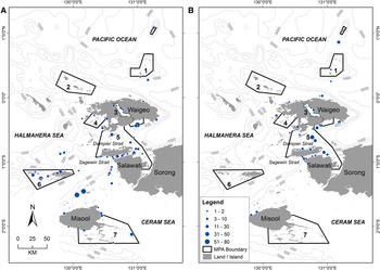
Distribution of whales and dolphins in Raja Ampat recorded in aerial surveys in January (A) and September (B) in 2006. Marine protected areas shown: 1, Ayau-Asia; 2, Kawe; 3, Mayalibit Bay; 4, Panjang Islands; 5, Dampier Strait; 6, Kofiau; 7, Misool.

The two most southerly MPAs are Kofiau (129°37′E 1°16′S) and Misool (130°33′E 2°02′S), which encompass 170,000 ha and 366,000 ha of islands and coastal waters, respectively (Figure 1). Kofiau MPA has 44 small islands in two major island groups (Kofiau and Boo) with shallow fringing reefs along the majority of the coastline. Deeper water (>200 m) is found within a few hundred metres to 0.5–2 km of the coastline. In the passage between Boo and Kofiau Islands water depth reaches >500 m. In contrast, Misool MPA encompasses the south-east coastline and dozens of offshore islands of the large island of Misool and is characterized by a labyrinth of geologically unique karst structures on a shallow shelf (<100 m).
Incidental sightings—coastal resources aerial surveys
Cetacean sightings were recorded during two aerial surveys in 2006 designed to document coastal resource use. Surveys were conducted from a small fixed wing aircraft, a Pilatus PC-6 (‘Pilatus Porter’) at an approximate height of 700 feet and speed of 100 km/h. The first survey was conducted from 9–13 January 2006 and the second between 8 and 22 September 2006. The same method was adopted for both the January and September surveys with each survey lasting for 30 hours over 5 days and covering approximately 4000 km along a targeted flight path. This allowed for direct comparison of the data. The survey team consisted of one navigator, two fishery observers (port and starboard) and two mappers (port and starboard) plus photographers. Observers recorded observations in an area extending 1.5 nautical miles from either side of the plane and recorded the GPS positions and took photographs of all whale and dolphin sightings. The flight path and survey methods were developed to allow maximum coverage of the near-shore reef areas of Raja Ampat to obtain information on the distribution and type of resource use activities in Raja Ampat, and marine mammal sightings were recorded opportunistically. Cetaceans could not be identified to species and were only recorded collectively as ‘whales and dolphins’. The distribution and abundance of cetaceans were plotted in ArcGIS.
Incidental sightings—boat-based surveys
Incidental sightings of cetaceans were made during boat-based surveys for reef health (annual) or resource use (4–16 days/year across different months), while traversing within Kofiau and Misool MPAs, or while travelling between the city of Sorong and the MPAs (Figure 1). Sightings were documented over 6 years from June 2006 to December 2011, with the exception of the months of June to August when all surveys ceased due to rough seas associated with the south-east monsoon season. Sightings were recorded in accordance with the ‘Occasional Observation Protocol’ developed by The Nature Conservancy (Muljadi & Nugrahaeni, Reference Muljadi and Nugrahaeni2006; Pratomo et al., Reference Pratomo, Setiawan, Wiadnya, Barmawi and Mous2006) and using identification keys in Carwardine (Reference Carwardine1995, Reference Carwardine2002). Data were collected by trained local scientists with over 5 years' experience in the field identifying cetacean species. There were two experts per MPA collecting data. Surveys were done with the naked eye at 150–170 cm above sea-level, and binoculars used to confirm identification. The number of survey trips taken per month was comparable and survey times ranged from 3–5 hours. Uncommon species were confirmed by showing photographs to other cetacean experts working in the region. If there was a concern about the identification of the animal, it was listed as dolphin or whale in the database. Observations were made only during the day. When cetaceans were sighted, the boat slowed or stopped and data were recorded including the GPS location of each sighting, species (where possible) and number of individuals, direction, distance of the observer from the target mammal, and behaviour of these mammals. Both MPAs are accessed across the same months, and at approximately the same frequency. Sightings were entered into a central database and analysed with ArcGIS and Microsoft Excel.
RESULTS
Incidental sightings—aerial surveys
Cetaceans were sighted throughout Raja Ampat with concentrations around southern Waigeo Island, the straits between Salawati and Batanta Islands, Kofiau MPA and small islands north of Misool Island (Figure 1A, B). The total number of whales and dolphins sighted in January (N = 629) was almost three times higher than in September (N = 241). This was particularly evident at Kofiau and the islands north of Misool Island, which had high counts of whales and dolphins in January but no or few sightings in September 2006 (Figure 1B). In contrast, whales and dolphins were abundant in the narrow Strait of Sagewin between southern Batanta and the Salawati Islands and in the Dampier Strait during both January and September (Figure 1A, B).
Although it was not possible to identify cetaceans to species level during the aerial surveys, observers sometimes noted and photographed species which are readily identified including killer (Orcinus orca Linnaeus, 1758) and false killer whales (Pseudorca crassidens Owen, 1846) (A. Muljadi, personal observations).
Incidental sightings—boat-based surveys
Whales and dolphins were encountered during boat-based surveys on 351 occasions between 2006 and 2011, over 417 days. The majority of sightings (300) were dolphins, comprising 3391 individuals. A total of 514 individual whales were encountered during 51 sightings. Because boat-based surveys were opportunistic, any potential inter-annual variation is more likely to result from the variation in survey effort and/or the variation in species distribution and abundance.
DOLPHINS
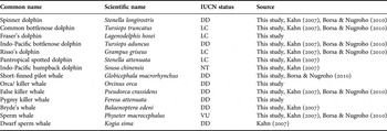
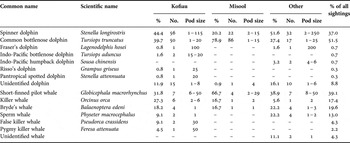
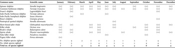
A total of seven species of dolphins were sighted in Raja Ampat (Table 1). Six dolphin species were observed in the Kofiau MPA, while only two species were sighted in Misool MPA (Table 2). Indo-Pacific humpback dolphins were recorded north of Misool Island (Table 2). This is the first study to record the occurrence of Fraser's dolphins (Lagenodelphis hosei Fraser, 1956) in Raja Ampat. Overall, the most common dolphins sighted in Raja Ampat were common bottlenose (Tursiops truncatus Montagu, 1821) (51.5% of all sightings) and spinner dolphins (Stenella longirostris Gray, 1828) (37.0% of sightings) (Table 2). The other 5 species were rarely seen in Raja Ampat and account for <1% of overall sightings. More dolphins were recorded in Kofiau MPA (1780 individuals) than in Misool MPA (516 individuals), over the 6 years of surveys. Common bottlenose and spinner dolphins were sighted year-round with no apparent temporal pattern (Table 3).

Percentage composition (%), number of sightings (No.) and pod size range of incidental sightings of dolphins and whales at Kofiau and Misool marine protected areas (MPAs), and other locations in Raja Ampat (‘Other’) from boat-based surveys from 2006–2011. Hyphens indicate the species was not sighted.

Whale and dolphin species sighted in different months between 2006 and 2011 during boat-based surveys in Raja Ampat. (+), indicates species was sighted at least once during this month.

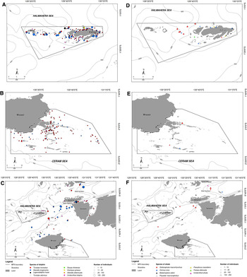
Dolphins were generally distributed throughout the entire area of Kofiau MPA (Figure 2A). Spinner dolphins were most frequently found in areas of deep water (>500 m) in the strait between Kofiau and Boo Island, south of Boo Island and also south of Kofiau Island. The two dolphin species sighted at Misool Island (spinner and common bottlenose) were sighted throughout the MPA (Figure 2B). Dolphins were commonly found in the waters between Sagewin Strait and Kofiau MPA (Figure 2C).
Distribution of dolphin species in Kofiau (A), Misool (B) and other areas of Raja Ampat (C); and the distribution of whale species in Kofiau (D), Misool (E) and other areas in Raja Ampat (F). Data pooled from 2006–2011.

WHALES
Six species of whales were recorded in Raja Ampat during boat-based incidental sightings—short-finned pilot (Globicephala macrorhynchus Gray, 1846), Bryde's (Balaenoptera edeni Anderson, 1879), sperm (Physeter macrocephalus Linnaeus, 1758), pygmy killer (Feresa attenuata Gray, 1875), false killer and killer whales (Tables 1 & 2). While killer and pygmy killer whales have been recorded in other parts of Indonesia, this is the first study to document the occurrence of these species in Raja Ampat.
Overall, short-finned pilot whales were the most commonly sighted whale species (39.1% of sightings) in Raja Ampat, often seen in groups of around 20 individuals (Table 2). Killer whales (17.4%) were documented in groups of 2–6 individuals. Bryde's whales (19.6%) and sperm whales (13.1%) were also frequently sighted individually or in pairs. Of the 6 records of sperm whales in Raja Ampat, 2 individuals were listed as stranded. These were the only stranded whales documented in Raja Ampat between 2006 and 2011. False killer and pygmy killer whales were sighted only three times during the survey in groups of 30 and 50, respectively. Six species of whales were sighted in the Kofiau MPA while only three species were seen at Misool MPA (Table 2).
Most of the whales sighted in the Kofiau MPA were in deep waters (>500 m) in the straits between Kofiau Island and Boo Island, with short-finned pilot whales being the most dominant species observed (Figure 2D). In Misool MPA, whales were only sighted in 2009 and 2010 (Figure 2E). All three sightings of short-finned pilot whales in Misool MPA were accompanied by pods of common bottlenose dolphins (up to 30 individuals) in close proximity. Orcas (2 individuals) and Bryde's whales (1 individual) were only sighted once in Misool in 2010 in the months of September and May, respectively. Although the area was less frequented by the speedboat, whales were documented in Dampier and Sagewin Straits, and the oceanic waters between Sagewin Strait and Kofiau MPA (Figure 2F).
DISCUSSION
Cetacean diversity
This and other studies have documented a total of 14 species of cetacean to date in Raja Ampat from incidental sightings from aerial and boat-based surveys (Kahn, Reference Kahn2007; Borsa & Nugroho, Reference Borsa and Nugroho2010; this study), which represents almost half of the 31 cetacean species recorded in Indonesia (Rudolf et al., Reference Rudolf, Smeenk and Leatherwood1997; Tomascick et al., 1997). This is the first published list of cetacean species from the region, and includes species such as Fraser's dolphins, killer and pygmy whales, which have not been recorded previously in Raja Ampat. Within the areas surveyed (central and southern Raja Ampat), the highest cetacean diversity and abundances were recorded in Dampier and Sagewin Straits and in Kofiau MPA. Incidental sightings from Raja Ampat suggest this Regency is an important area for cetaceans in Indonesia, and it is likely that additional systematic surveys by cetacean experts would document even more species.
With the exception of Komodo National Park which recorded 18 species of cetaceans over 71 fieldwork days (Kahn & Pet, Reference Kahn, Pet, Beumer, Grant and Smith2003), all other surveys in Indonesia have recorded lower number of cetaceans. For example, incidental sightings from similar boat-based surveys over multiple years in Derawan and Wakatobi MPAs in central Indonesia documented only 6 and 9 species of cetaceans, respectively (The Nature Conservancy, unpublished data). Kreb & Budiono (Reference Kreb2005) documented 10 species of cetaceans over 80 days of survey in the Derawan Archipelago. Boat-based surveys in the Solor-Alor Straits recorded 12 species of cetaceans (Kahn, Reference Kahn2005), while Kaimana (south of Raja Ampat) recorded 6 species (Kahn, Reference Kahn2009).
Dampier and Sagewin Straits have been suggested to be important cetacean migration corridors (Kahn, Reference Kahn2007; Wilson et al., Reference Wilson, Rotinsulu, Muljadi, Wen, Barmawai and Mandagi2010), and this study provides further evidence to support this. Raja Ampat is strongly influenced by the Indonesian flowthrough, the major oceanic exchange between the West Pacific and Indian Ocean (Vranes & Gordon, Reference Vranes and Gordon2005) and large whales, such as blue and sperm whale are known to migrate to Indonesia from both the Indian and Pacific Oceans (Carwardine, Reference Carwardine2002). Corridors can be highly important for the long-term viability of cetacean populations (Reeves, Reference Reeves2000).
Short-finned pilot whales, a species known to associate with other cetaceans (Jefferson et al., Reference Jefferson, Leatherwood and Webber1993) were the most commonly sighted whale in Raja Ampat. The Bryde's whale are considered by some as the least known tropical marine mammal in the Asia-Pacific (Kahn, Reference Kahn2007), yet they were commonly seen in Raja Ampat and other parts of the BHS (Kahn, Reference Kahn2009; Mangubhai et al., Reference Mangubhai, Erdmann, Wilson, Huffard, Ballamu, Hidayat, Hitipeuw, Lazuardi, Pada, Purba, Rotinsulu, Rumetna, Sumolang and Wen2012). This suggests that Raja Ampat and the wider BHS is a regional stronghold for Bryde's whales. Common bottlenose and spinner dolphins were observed year-round, which suggests that there may be resident populations in the Regency.
The abundance of top predators, such as bottlenose dolphins is considered by some as an indicator of the health of coastal habitats (Hart, Reference Hart2011; Reif, Reference Reif2011). Similar to Borsa & Nugroho (Reference Borsa and Nugroho2010), our study found spinner dolphins were the most common dolphin species in Raja Ampat. There may be two potential sub-species of spinner dolphins in the Regency—the pelagic and dwarf species (Borsa & Nugroho, Reference Borsa and Nugroho2010), that warrant further study. A resident population of Indo-Pacific humpback dolphins has also been documented in Mayalibit Bay MPA, north of Dampier Strait (Kahn, Reference Kahn2007; Conservation International, unpublished data).
The high cetacean diversity in Raja Ampat is likely due to the complex bathymetry which includes deep sea (>500 m) areas close to the coast, the presence of seamounts and pinnacles and ‘bottlenecks’ for cetacean movement through the straits (Kahn, Reference Kahn2007). Nutrient rich waters and seasonal upwellings (Mangubhai et al., Reference Mangubhai, Erdmann, Wilson, Huffard, Ballamu, Hidayat, Hitipeuw, Lazuardi, Pada, Purba, Rotinsulu, Rumetna, Sumolang and Wen2012) likely support important feeding grounds for migrating and resident cetaceans (Borsa & Nugroho, Reference Borsa and Nugroho2010; Wilson et al., Reference Wilson, Rotinsulu, Muljadi, Wen, Barmawai and Mandagi2010). Cetacean distribution is dependent on habitat characteristics, such as bathymetry (Cañadas & Sagarminada, Reference Cañadas and Sagarminaga2000; Kiszka et al., Reference Kiszka, Macleod, Van Canneyt, Walker and Ridoux2007) and distinct habitat partitioning may occur along depth gradients. For example, bottlenose dolphins are thought to be continental shelf species, while short-finned pilot whales and Risso's dolphins (Grampus griseus Cuvier, 1812) are upper continental slope species, and sperm whales are lower continental slope species (Davis et al., Reference Davis, Fargion, May, Leming, Baumgartner, Evans, Hansen and Mullin1998, Reference Davis, Ortega-Ortiz, Ribic, Evans, Biggs, Ressler, Cady, Leben, Mullin and Würsig2002; Baumgartner et al., Reference Baumgartner, Mullin, May and Leming2001). During aerial surveys in January and September 2006, cetaceans were sighted both in shallow coastal areas and in water deeper than 500 m. The wider depth range found at Kofiau possibly contributes to the higher diversity and numbers of cetaceans sighted within and around the MPA compared with Misool further south.
While this study recognizes the limitations of incidental sightings for understanding spatial and temporal patterns in cetacean distribution, the data are invaluable as a basis for more detailed and comprehensive surveys in the region, and can be used by managers to better manage threats to these species (see below). The study adds new data to at least 7 species of cetaceans listed as ‘Data Deficient’ by IUCN (2012), and highlights the importance of Raja Ampat not only for coral and reef fish diversity, but also for resident and migratory cetaceans. The data presented in this paper can be used by policy and decision makers responsible for protecting and managing these species in Indonesia.
Emerging threats and challenges
Government policies are being revised to encourage the rapid expansion of oil and gas exploration and production throughout Indonesia, including Raja Ampat and other parts of the BHS (Mangubhai et al., Reference Mangubhai, Erdmann, Wilson, Huffard, Ballamu, Hidayat, Hitipeuw, Lazuardi, Pada, Purba, Rotinsulu, Rumetna, Sumolang and Wen2012). Seismic testing and other forms of extreme underwater noise can disturb and displace cetaceans (McCauley et al., Reference McCauley, Fewtreli, Duncan, Jenner, Jenner, Penrose, Prince, Adhitya, Murdoch and McCabe2000; Stone & Tasker, Reference Stone and Tasker2006; Castellote et al., Reference Castellote, Clark and Lammers2012) and their prey (McCauley et al., Reference McCauley, Fewtrell and Popper2003; MacKenzie, Reference MacKenzie2004), and even lead to strandings (Yang et al., Reference Yang, Chou, Jepson, Brownell, Cowan, Chang, Chiou, Yao, Yamada, Chiu, Wang and Fernández2008). Several mining leases have already been issued for areas identified as potential migratory pathways in Raja Ampat, and at least four vessels were reported conducting seismic surveys in the Regency in 2010 (Mangubhai et al., Reference Mangubhai, Erdmann, Wilson, Huffard, Ballamu, Hidayat, Hitipeuw, Lazuardi, Pada, Purba, Rotinsulu, Rumetna, Sumolang and Wen2012). Currently seismic vessels operating within Indonesia are not legally required to comply with international standards to reduce impacts to cetaceans (Kahn, Reference Kahn2010).
Aerial surveys also documented high numbers of vessels in January and September 2006 in Kofiau (>50 vessels) and Dampier Strait MPAs (>40 vessels) (Wilson et al., Reference Wilson, Rotinsulu, Muljadi, Wen, Barmawai and Mandagi2010). In addition, high numbers of vessels (150–200) were recorded in the area around Sorong city and Batanta and Waigeo Islands, including freight and industrial vessels (5–15). These areas of high vessel traffic overlapped with key areas where cetaceans were sighted, and therefore these species face increasing risk of strikes and noise pollution from vessel traffic in and out of the port of Sorong. Vessel collisions can injur or kill cetaceans (Ford et al., Reference Ford, Ellis and Balcomb2000) and high traffic can lead to disturbance and displacement from habitats (Bejder et al., Reference Bejder, Samuels, Whitehead and Gales2006). Similar to seismic surveys, vessel noise can mask echolocation signals and impair foraging (Erbe, Reference Erbe2002; Aguilar Soto et al., Reference Aguilar Soto, Johnson, Madsen, Tyack, Bocconcelli and Borsani2006). Bomb fishing continues in Raja Ampat (including occassionally in MPAs) and may add additional noise stress to cetaceans residing or frequenting the Regency's waters (Purwanto & Muhajir, personal observations).
Entanglement in coastal fishing nets can drown or chronically injure cetaceans (Moore & Van der Hoop, Reference Moore and Van der Hoop2012), and this can have population-wide effects even if a small percentage of the population is captured (Negri et al., Reference Negri, Denuncio, Panebianco and Cappozzo2012). Many of the vessels documented by Wilson et al. (Reference Wilson, Rotinsulu, Muljadi, Wen, Barmawai and Mandagi2010) were engaged in fishing activities. Where the distribution of cetaceans overlaps with MPAs, regulations to manage commercial fishing may provide some protection. However, other areas such as Sagewin Strait and some parts of Dampier Strait are outside MPA boundaries (Figure 2) and do not have regulations in place to manage potential threats to resident or migrating cetaceans.
High levels of plastic pollution occur around urban areas in Raja Ampat such as Sorong and Waisai, especially after high rainfall (Mangubhai et al., Reference Mangubhai, Erdmann, Wilson, Huffard, Ballamu, Hidayat, Hitipeuw, Lazuardi, Pada, Purba, Rotinsulu, Rumetna, Sumolang and Wen2012; Purwanto & Muhajir, personal observations). Plastic and marine debris is an increasing ‘cryptic’ threat to cetaceans worldwide and if ingested can cause illness to or death of cetaceans (Jacobsen et al., Reference Jacobsen, Massey and Gulland2010; Simmonds, Reference Simmonds2012) and could impact populations residing or migrating to Raja Ampat.
The high diversity and large number of cetaceans relatively close to shore in Raja Ampat creates a unique additional opportunity for the burgeoning dive-based tourism industry. As the Regency expands its tourism sector, there may be opportunities to offer whale watching to visitors which may bring additional revenue to the government and local communities. However, to ensure the maintenance of healthy and diverse cetacean assemblages in Raja Ampat, a wider conservation strategy will need to be put in place to address or better manage emerging threats to Raja Ampat, and to ensure the long-term protection of resident and migratory dolphin and whale species.
ACKNOWLEDGEMENTS
We thank T. Nugrahaeni, R. Lantang, M. Syakir, D.A. Wibowo and the supporting boat captains and crew for contributing to this dataset. We are grateful to B. Kahn for confirming photo-identification of cetacean species where needed, and to S. Leahy for assisting with GIS maps. This work was funded by the David and Lucille Packard Foundation, Walton Family Foundation, USAID and private donors, and conducted under a memorandum of understanding between The Nature Conservancy and the Nature Conservation Agency of the Indonesian Ministry for Forestry.