INTRODUCTION
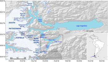
Lago Argentino is the sixth largest lake in South America and the second largest in Patagonia (Fig. 1). It comprises a main W–E-elongated, ellipsoid-shaped water body (ca. 60 × 15 km) and a series of structurally controlled, deeply entrenched transversal and longitudinal glacial valleys that extend toward the west and south into the mountain ranges of the South Patagonian Icefield (SPI), the largest temperate ice mass of the Southern Hemisphere. Eight major outlet glaciers originated from SPI, and they presently flow into the Lago Argentino arms. The largest of these glaciers is the Upsala glacier, and the most famous is the Perito Moreno glacier.
General physiographic map of the study area (location in the blue box of the index map in the bottom right corner) with the main glaciers flowing to the Lago Argentino arms from the eastern margin of the South Patagonian Icefield. Black box indicates the study area. (For interpretation of the reference to color in this figure legend, the reader is referred to the web version of this article.)

The Lago Argentino basin was selected as a prime location to refine the late Pleistocene–Holocene glacial history, and thus knowledge of paleoclimate in the southern Patagonian Andes, because of the occurrence of well-preserved glaciogenic landforms and stratigraphic exposures (Mercer, Reference Mercer1965; Mercer and Ager, Reference Mercer and Ager1983). During the Pleistocene, Lago Argentino outlet glaciers underwent repeated episodes of advance and retreat (Strelin and Malagnino, Reference Strelin and Malagnino1996) before the deep recessional phase into the Andean Cordillera at around 12,650 cal yr BP (Strelin et al., Reference Strelin, Denton, Vandergoes, Ninnemann and Putnam2011). Regional climate warming and accelerated calving of glacial fronts in recent decades are considered to be responsible for marked ice recession on both sides of the SPI (Rignot et al., Reference Rignot, Rivera and Casassa2003; Glasser et al., Reference Glasser, Harrison, Jansson, Anderson and Cowley2011). This is dramatically illustrated through analysis and comparison of available photographs and satellite-derived optical images (e.g., White and Copland, Reference White and Copland2013; Foresta et al., Reference Foresta, Gourmelen, Weissgerber, Nienow, Williams, Shepherd, Drinkwater and Plummer2018). However, some of the outlet glaciers in the Lago Argentino area under similar climatic conditions appear to show significant differences in their frontal fluctuations (Aniya et al., Reference Aniya, Sato, Naruse, Skvarca and Casassa1997; Sakakibara and Sugiyama, Reference Sakakibara and Sugiyama2014). This behavior presented several difficulties for short- and long-term interpretations. As an example, four of the larger glaciers (Upsala, Onelli, Ameghino, and Frías) underwent considerable recession, leaving behind many middle to late Holocene moraine systems. Three other glaciers (Agassiz, Spegazzini, and Mayo) have retreated slowly and remain close to their maximum late Holocene positions.
Reaching its maximum position in the beginning of the last century, the behavior of the Perito Moreno glacier distinguishes it as a separate and special case (Mercer, Reference Mercer1976; Skvarca and Naruse, Reference Skvarca and Naruse1997; Guerrido et al., Reference Guerrido, Villalba and Rojas2014). The glacier oscillated near this advanced position, losing a few meters of ice thickness at the terminus in the last decade. Periodic advances of the Perito Moreno glacier's front at intervals varying from about 4 yr to a few months form a natural ice dam as it progresses across the rocky shore of the Magallanes Peninsula. That event blocks the water flow from the Brazo Rico–Brazo Sur arms of Lago Argentino, raising their water level, until the water is released violently in a major outburst flood, as occurred most recently on March 12, 2018.
Several attempts to explain the discrepancy in the modern glacier's behavior have been proposed in literature, including changes in local climate factors that affected mass balance and valley geometry, that is, the areal distribution of glaciers with regard to their surface elevations (Mercer, Reference Mercer1965). In such cases, low-gradient glaciers may respond to climate fluctuations differently than short, steep glaciers (Strelin et al., Reference Strelin, Kaplan, Vandergoes, Denton and Shaefer2014).
At present, the eight main Lago Argentino outlet glaciers terminate, at least partly, in proglacial lakes, and thus calving is an important control on their frontal dynamics. For the Perito Moreno glacier, it has been proposed that its seasonal ice-front variations are primarily due to frontal ablation (subaqueous melting), which is well correlated with seasonal lake-water temperature variations (Minowa et al., Reference Minowa, Sugiyama, Sakakibara and Skvarca2017). Today, the Grande glacier (former Frías glacier) terminates in a small moraine-dammed proglacial lake about 8 km from the southern shore of the Brazo Sur, with a series of moraine ridges formed in the final outwash plain (Strelin et al., Reference Strelin, Kaplan, Vandergoes, Denton and Shaefer2014; Kaplan et al., Reference Kaplan, Schaefer, Strelin, Denton, Anderson, Vandergoes and Finkel2016). According to Strelin et al. (Reference Strelin, Kaplan, Vandergoes, Denton and Shaefer2014), only recently has the small proglacial lake inverted its drainage from the Atlantic to the Pacific Ocean, in conjunction with a northern shift of the entire continental watershed in this region.
This work is focused on the analysis of sedimentary bodies linked to the late-glacial dynamics of the Perito Moreno and former Frías glaciers along the two southern arms of Lago Argentino. It is important to point out that the reconstructions of their various post–last glacial maximum (LGM) phases were carried out mostly on outcrops (Strelin et al., Reference Strelin, Kaplan, Vandergoes, Denton and Shaefer2014, and references therein), while very few specific studies have been done within the two Brazo Rico and Brazo Sur branches of the Lago Argentino (Del Valle et al., Reference Del Valle, Skvarca, Manzini and Lusky1995). To investigate the submerged expression of these glacial landforms and to identify potential additional moraine belts presumably present within these two lake arms, we conducted a series of geophysical campaigns in the Brazo Rico and Brazo Sur. The identification of submerged moraine bodies within these arms of the Lago Argentino represents the decisive element for reconstructing the dynamics of the Perito Moreno and former Frías glacial fronts. Furthermore, through the analysis of the morphology, shape, and acoustic characteristics of these sedimentary ridges, important information can be obtained to discriminate the advance/still stand and recessional phases of the glaciers themselves.
In this study, we present the results derived from the interpretation of a large number of high-resolution seismic and bathymetric profiles. These data allowed us to: (1) identify features indicative of the late-glacial major fluctuations, expressed by subaqueous moraine complexes; (2) correlate these glacier-related features with those mapped onshore along the lakeshores, the oldest being the 12,660 ± 70 cal yr BP Puerto Bandera 3 moraine (Strelin et al., Reference Strelin, Denton, Vandergoes, Ninnemann and Putnam2011); (3) propose, on the basis of the seismic characteristics of the identified submerged bodies, an evolutionary scheme for the two outlet glaciers flowing along the Brazo Rico and Brazo Sur; and (4) compare the geomorphological and seismostratigraphic characteristics of the Brazo Rico/Sur subaqueous moraine systems with those studied in other physiographic contexts in high-latitude lakes and fjord systems, revealing analogies both in the moraine features and glacial dynamics.
METHODOLOGY
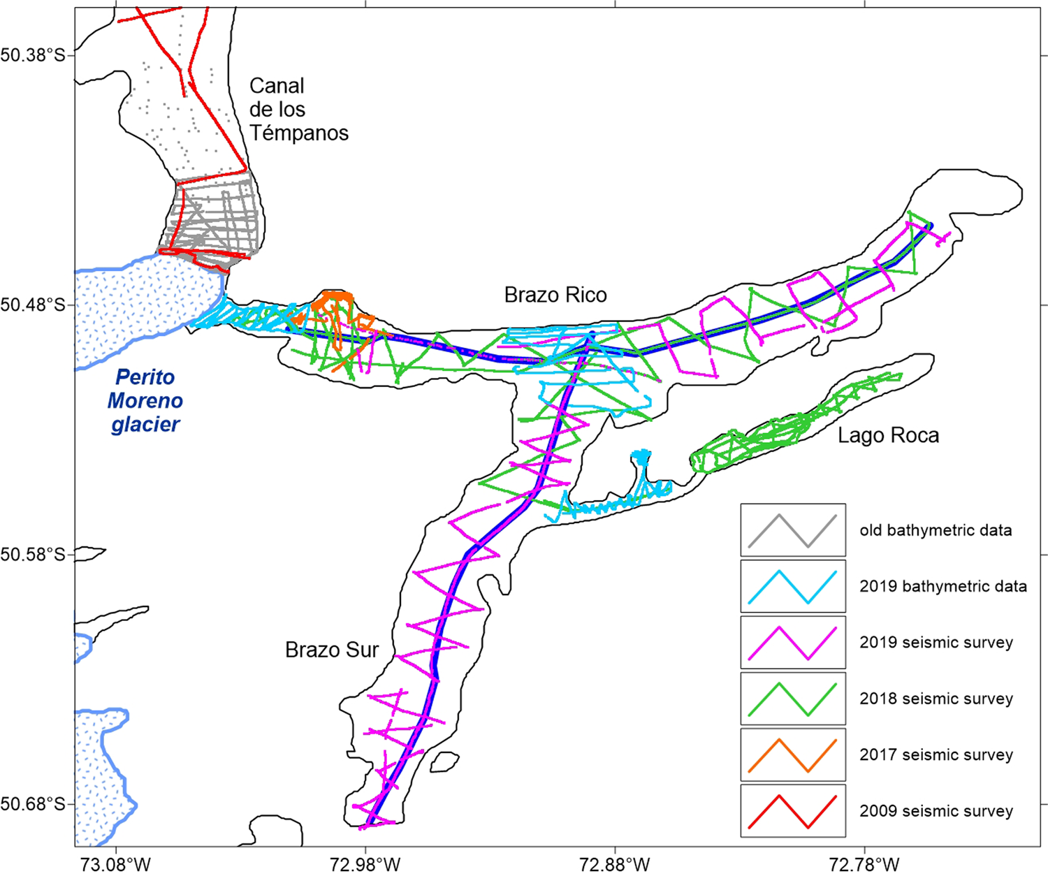
Between November 2017 and April 2019, three geophysical campaigns have been carried out in the Brazo Rico and Brazo Sur of the Lago Argentino (Figs. 1 and 2). High-resolution seismic profiles, complemented with bathymetric profiles, were acquired in these two arms of Lago Argentino for a total length of 442 km of data. In addition, we have performed an integrated analysis of both our data and some old profiles acquired in the southern part of Canal de los Témpanos (bathymetric data acquired with a hydrographic depth sounder between 1980 and 1990), complemented with some high-resolution profiles collected by us in 2009, to produce the bathymetric map.
Data location map, differentiated by colors (see legend), indicating the different surveys performed in the area. Old bathymetric data refer to profiles acquired with a hydrographic depth sounder between 1980 and 1990. The two bold blue lines represent the high-resolution seismic profiles presented in Figs. 5 and 6.

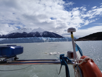
Seismic data were acquired with a Boomer source composed of an electrodynamic plate mounted on a catamaran and suspended at a depth of ca. 40 cm below the lake level (Fig. 3). The plate is powered by a group of capacitors connected to a 3.5 kW generator. The generated pulse is a broad-spectrum impulsive type (400–6000 Hz with a dominant frequency of 2000 Hz) and provides submetric resolution. The receiving system was a multichannel streamer composed of eight pre-amplified hydrophones distributed over an active section of 22 m. A differential GPS interfaced with the acquisition system guaranteed the correct positioning of the collected tracks (WGS84 ellipsoid reference frame). Sampling rate was 0.125 ms, shot frequency was 3 shots every 2 s, and record length was 600 ms, acquiring the data with an average boat speed of ca. 6.4 km/h (4 knots). In general, the maximum acoustic penetration was about 120 m below the lake floor with ca. 0.2 m of vertical resolution. Seismic data processing to produce the final seismic images comprises the following steps: (1) electrical disturbances and noise attenuation by averaging the amplitudes and frequencies on temporal windows of groups of adjacent traces; (2) spherical divergence correction and automatic gain control (with a 10–20 ms windows); (3) band-pass filters applied according to the spectral characteristics of the individual profiles; (4) velocity analysis using a constant velocity stack algorithm; (5) normal move out and stack; and (6) Kirchhoff time migration.
The Boomer system used for the acquisition of the high-resolution seismic profiles. The catamaran and the seismic streamer are towed by the Zodiac boat during data collection. In the background, the front of the Perito Moreno glacier in the Brazo Rico.

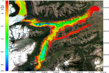
The bathymetric map (Fig. 4), which represents the basis for the identification of the moraine bodies, along with the seismic profiles, was created by combining both echo-sounder bathymetric profiles and seismic-derived bathymetric profiles. It covers Brazo Sur and Brazo Rico and the southern part of Canal de los Témpanos. The bathymetry of the southern part of the Canal de los Témpanos was primarily obtained using old profiles available on paper acquired in the late 1970s and early 1980s with a hydrographic echo-sounder. These data have been georeferenced and subsequently digitized in the WGS84 reference frame and complemented with some high-resolution seismic profiles acquired in 2009. The bathymetry of the Brazo Rico and Brazo Sur has been obtained by digitizing the first arrival on all the available seismic data in these two sectors, and the resulting two-way travel time (TWT) has been converted in water depths, applying the water lake sound velocity of 1432 m/s (Zanolla et al., Reference Zanolla, Lodolo, Lippai, Tassone, Menichetti, Baradello, GrossI and Hormaechea2011). Considering that the seismic surveys were performed in different periods, and that the Brazo Rico/Brazo Sur lake levels were different (higher with respect to the Canal de los Témpanos) due to the ice damming of the Perito Moreno glacier (the largest reported difference between the two lake levels was + 26 m; Liss, Reference Liss1970), we leveled all the profiles at the same datum of the Canal de los Témpanos and Lago Argentino (present-day average lake level: +187 m above sea level). This was achieved by analyzing the difference in time at the intersections among all the seismic lines, and the obtained value was then subtracted to bring it back to the lake level of the Canal de los Témpanos. The final bathymetric map was obtained by applying the Kriging interpolation technique (with a radius of 50 m), which considers both the distance and the degree of variation between known data points when estimating values in unknown areas. This method proved to be the best compared with the other interpolation methods, considering the sparse distribution of our profiles and the distance between the various lines acquired.
Bathymetric map of the Brazo Rico and Brazo Sur, derived from high-resolution seismic and bathymetric profiles acquired in different surveys (see map in Fig. 2).

SEISMIC CHARACTERISTICS OF THE SUBAQUEOUS MORAINES
Different types of glacier-related deposits generated by the late-glacial fluctuations of the Perito Moreno and former Frías glaciers have been recognized in the two southern arms of the Lago Argentino. The nonhomogeneous distribution of the seismic profiles and their significant spacing do not allow accurate reconstruction of the complete morphology of these sedimentary bodies and their size. However, it was possible to identify the main moraine ridges that can be linked with the fluctuations of the two main glaciers within the Brazo Rico and Brazo Sur, that is, the Perito Moreno and former Frías glaciers, respectively. Moreover, the two longitudinal composite seismic profiles acquired along these two branches of Lago Argentino have allowed us to image the gross seismostratigraphic setting of these lake arms. Based on the acoustic characteristics, we identified three main seismic facies that reveal some similarities with the stratigraphic setting and depositional architecture of the Lago Fagnano in Tierra del Fuego (Waldmann et al., Reference Waldmann, Ariztegui, Anselmetti, Coronato and Austin2010; Esteban et al., Reference Esteban, Tassone, Lodolo, Menichetti, Lippai, Waldmann, Darbo, Baradello and Vilas2014). The seismic character of the facies that we have distinguished is highlighted by the two longitudinal seismic lines presented in Figs. 5 and 6.
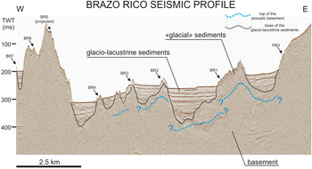
(color online) Longitudinal composite seismic profile along Brazo Rico, showing the main morphological features and the glacier-related depositional bodies (see location in Fig. 2).

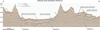
(color online) Longitudinal composite seismic profile along Brazo Sur, showing the main morphological features and the glacier-related depositional bodies (see location in Fig. 2).

Seismic facies A is characterized by a medium- to high-amplitude, chaotic, reflection-free seismic response. We interpret this seismic facies as representing the bedrock/basement complex. The top of this seismic facies is represented by a highly irregular surface, often affected by diffraction hyperbolae. In our high-resolution seismic profiles, this surface is the deepest reflector detectable from seismic profiles (i.e., the acoustic basement).
Seismic facies B is represented in general by a chaotic acoustic response, with an overall irregular morphology, characterized by poor to modest lateral continuity, which commonly covers the lower, rough basement morphology. We interpret this facies as the glacial infill, hereafter named “glacial,” following Waldmann et al. (Reference Waldmann, Ariztegui, Anselmetti, Coronato and Austin2010).
Seismic facies C is represented by a package of reflectors that can be distinguished in an almost 16 to 25 m constant thickness that commonly follows the lower, rough morphology, and by up to 130-m-thick well-layered configurations of subhorizontal, subparallel, and continuous reflectors. The interval acoustic velocity used to calculate the thickness of this sediment layer from TWT was 1650 m/s, according to Waldmann et al. (Reference Waldmann, Ariztegui, Anselmetti, Coronato and Austin2010) and Esteban et al. (Reference Esteban, Tassone, Lodolo, Menichetti, Lippai, Waldmann, Darbo, Baradello and Vilas2014). We interpret this facies as glacio-lacustrine deposits.
Preserved subaqueous moraines record punctuated events during an overall glacial advance (terminal moraines) or recession (recessional moraines). It is important to note that most of the former moraines produced during the advance of the glacier are progressively erased, and only the moraine at the end of the advance remains preserved. In contrast, in the case of the retreat/still stand of a glacier, an almost continuous record of the moraine system is preserved. As is well known, moraine morphology and composition (sediment debris ranging in size from silt-sized glacial flour to large boulders) are extremely variable, and their classification based on type and glacial dynamics may be in some cases largely speculative, especially when direct sampling is not available, as in our case. However, the key factor that determines their morphology and their internal characteristics is the type of movement of the glacial front and its thrust energy, which acts as a bulldozer in the phase of significant advance, while in the phase of withdrawal or stationarity, the glacier releases the material that has in charge, depositing it immediately below its front. The terminal moraines involve extremely variable sedimentary material both in composition and granulometry, and in many cases they also incorporate large boulders, which in seismic profiles produce a series of diffractions and spurious reflections, and coarse-grained sediments deposited at the ice margin, possibly as ice push or meltout material, as occurs, for example, in some Norwegian moraines (Eilertsen et al., Reference Eilertsen, Longva, Corner, Dowdeswell, Canals, Jakobsson, Todd, Dowdeswell and Hogan2016). Recessional moraines, on the other hand, are deposited in a predominantly stationary regime and are commonly characterized by layered sequences (e.g., flow till). This would indicate that they originated from subglacial meltwater at the grounded glacial front and were produced in large amounts during deglaciation, as is also hypothesized for perialpine lake moraines (e.g., Hilbe et al., Reference Hilbe, Strupler, Hansen, Eilersten, Van Daele, De Batist, Anselmetti, Dowdeswell, Canals, Jakobsson, Todd, Dowdeswell and Hogan2016). Studies carried out in alpine lakes (Fabbri et al., Reference Fabbri, Buechi, Horstmeyer, Hilbe, Hübscher, Schmelzbach, Weiss and Anselmetti2018) and in lakes of the British Islands (Pinson et al., Reference Pinson, Vardy, Dix, Henstock, Bull and MacLachlan2012) using similar geophysical methods as those used in this work have proposed a diversification between the various glacial deposits based on specific seismic facies and architecture and analogies with available ground outcrops. However, it is often difficult to find correspondences between very different depositional and glacial settings, which prevents a general classification that applies to all environments.
Similar to subaqueous moraines recorded in other physiographic contexts, it is evident that the position of the moraine bodies of Lago Argentino is controlled by bedrock highs, which provide a pinning point and allow the glacial front to be grounded (Dowdeswell and Vásquez, Reference Dowdeswell and Vásquez2013). According to these general considerations, we may say that the moraine bodies identified along both the Brazo Rico and Brazo Sur mark the glacial recessions and/or still stands within the general regime of late-glacial retreat phase
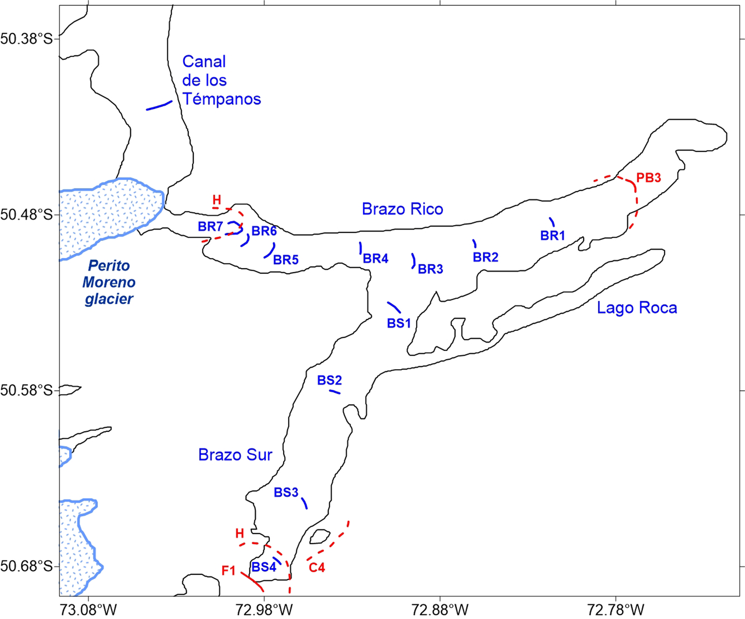
The location of all the moraine ridges identified from seismic data is illustrated in Figure 7. We would like to emphasize that the moraine arches that we have mapped are those where we have been able to recognize a certain morphological continuity, because they are crossed by multiple seismic profiles. The isolated bodies identified on the lake floor, crossed only by a single seismic line, have not been mapped. In some cases, these isolated bodies represent out-of-line reflected events. Based on the characteristics of the moraine complexes intercepted by our seismic profiles, and according to the general considerations reported earlier, we have distinguished between terminal (type A) and recessional (type B) moraines. It should be emphasized that this diversification is essentially based on the acoustic characteristics of the moraine bodies and their morphology, and provides a method for discriminating the dynamics of the glacier in the absence of direct information from field studies. In general, the good state of preservation of these moraines, as imaged in our seismic profiles, suggests that it is unlikely that these have been overridden since their formation.
Location map of the moraines identified from the interpretation of the high-resolution seismic profiles, in combination with the bathymetric data. The abbreviations for moraines are those described in the text and presented in Figs. 8 and 9. The approximate position of the moraines labeled (in red) as PB3 (Puerto Bandera 3), F1 (Frías 1), H (Herminita), and C4 (Cachorro 4) are taken from Strelin et al. (Reference Strelin, Denton, Vandergoes, Ninnemann and Putnam2011, Reference Strelin, Kaplan, Vandergoes, Denton and Shaefer2014). (For interpretation of the reference to color in this figure legend, the reader is referred to the web version of this article.)

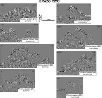
Seismic sections showing the identified moraines in the Brazo Rico. The abbreviations for moraines are those described in the text, with location noted in Fig. 7.

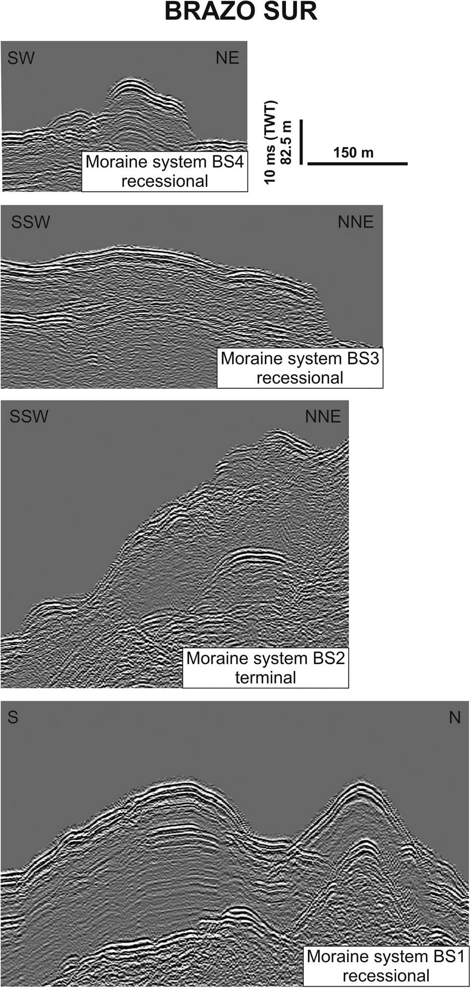
Seismic sections showing the identified moraines in the Brazo Sur. The abbreviations for moraines are those described in the text, with location noted in Fig. 7.

Type A terminal moraines are sediment ridges characterized by a general rough morphology, internally revealing a low- to medium-amplitude, predominantly chaotic facies, where frequent acoustic diffractions are present. They are commonly 10 to 20 m high, whereas their areal extent varies greatly and is difficult to estimate, because it depends on how and in which direction they are crossed by the seismic data and because they are often constituted of several sediment ridges.
Type B recessional moraines are internally represented by a layered seismic facies made by low- to medium-amplitude reflectors, with a generally dome-shaped morphology, and present both symmetrical and asymmetrical flanks. Single, isolated sediment ridges are commonly 10 to 20 m high. Some of these subaqueous landforms may in some cases represent proglacial deposits during glacial still stand phases.
BRAZO RICO
The bathymetric map (see Fig. 4) shows that the deepest area of the Brazo Rico, reaching almost 270 m in water depth, is located in its western side. Eastward, the lake floor is shallower, with an average depth ranging between 200 and 250 m. The morphology of Brazo Rico is compartmented in E–W-elongated subbasins, separated by two N–S main structural ridges located near longitudes 73°W and 72.8°W. Another three to four small structural ridges can be recognized in the western side, confining depocenters smaller than 2 km in length. The easternmost part of Brazo Rico is characterized by a smooth gravel–sandy plain shallower than 10 m.
The composite longitudinal seismic profile collected within the Brazo Rico (Fig. 5) reveals a quite rough lake morphology, especially in its westernmost part compared with its central and eastern parts, where wide, almost flat areas are present. It is often difficult to discriminate between the basement and the buried glacier-related bodies (ancient moraine complexes) due to a similar acoustic response, except in limited areas. Toward the east, the lake morphology is smoother, and the occurrence of facies C progressively becomes predominant, with a maximum sediment thickness of ca. 130 m being recorded in the central part of Brazo Rico. A significant change in the overall bathymetric profile is found at the confluence with Brazo Sur, where the deposits come from the two glaciers, Perito Moreno and former Frías. At the lake floor, both type A and type B moraines are identifiable (see Fig. 7). All along the Brazo Rico, we identified eight subaqueous moraine systems. It should be emphasized that we have no information on the lake-floor morphology of both arms in the immediate vicinity of the front of the Perito Moreno glacier. This is because safety regulations (frequent ice falls from the glacial terminus) preclude getting any closer to the front. The seismic images of each of these moraine bodies, with their general characteristics, are presented in Figure 8. From west to east, the first evidence of moraine body is found at a distance of ca. 3600 m from the present-day terminus of the Perito Moreno glacier. It has a type A seismic character, thus representing the youngest occurrence of terminal moraine produced by the advance of Perito Moreno front (called here moraine Brazo Rico 7). This moraine could represent the subaqueous expression of the moraine complex known as the Peninsula Herminita moraine, studied in the field along the northernmost arm of the Lago Argentino where the Upsala glacier flowed (Malagnino and Strelin, Reference Malagnino, Strelin, Naruse and Aniya1992). Here, dated basal peat bogs provide a minimum age of 12,220 ± 110 cal yr BP (Strelin et al., Reference Strelin, Denton, Vandergoes, Ninnemann and Putnam2011).
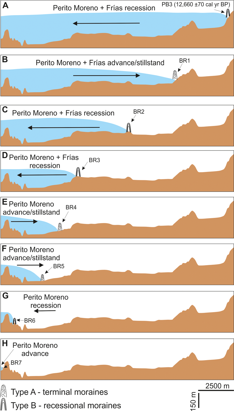
Along the southern part of Canal de los Témpanos, which represents the other arm of Lago Argentino where the Perito Moreno calves, a sediment ridge ascribable to the youngest moraine system is found at a distance of 3500 m from the present-day glacial front. Three other moraine fronts have been individuated to the east of the Brazo Rico 7 moraine, called here Brazo Rico 6, 5, and 4. The stratigraphic characteristics of the identified moraine bodies and their seismic facies in this sector of the Brazo Sur would indicate that Brazo Rico 6 is a recessional moraine, whereas Brazo Rico 4 and 5 represent terminal moraines. At the confluence between Brazo Rico and Brazo Sur, both moraine types are identifiable, although type B recessional moraines seems to prevail (Brazo Rico 3 moraine). In this area, the confluence of the two main glaciers took place: the Perito Moreno, coming from the west, and former Frías glacier, coming from the south almost entirely along the Brazo Sur (see fig. 16 of Strelin et al., Reference Strelin, Denton, Vandergoes, Ninnemann and Putnam2011). The two coalesced glaciers advanced along the eastern arm of the Brazo Rico, where we have evidence of at least three moraine systems. The farthest, that is, the easternmost front, is represented by the subaqueous part of the Puerto Bandera 3 (PB3) moraine mentioned earlier, which is a recessional moraine (type B), whereas Brazo Rico 1 and 2 moraine characteristics would suggest they represent a terminal and a recessional moraine, respectively.
BRAZO SUR
The maximum water depth in the Brazo Sur is 240 m, located near latitude 50.62°S. The southern part of this arm presents a N–S-elongated depression, while the northern part is quite rugged, with a stepped morphology consisting of three main broadly E–W-oriented ridges that bound subbasins with water depths of about 100 m. The connection with Lago Roca, where water depths are <30 m, is characterized by a quite smooth morphology, with water depths shallower than 20 m. At the confluence with Brazo Rico, Brazo Sur sharply deepens to more than 200 m.
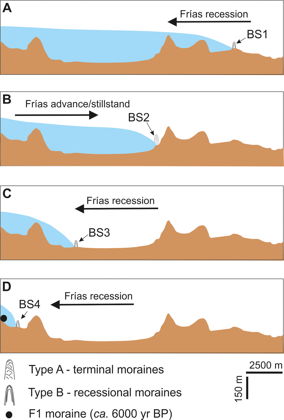
The composite longitudinal seismic line collected all along the Brazo Sur (Fig. 6) reveals that facies C predominates, except in limited areas where facies A and/or B outcrop. The seismic profiles reveal a central, well-layered basin (facies C), which progressively deepens northward, reaching a maximum thickness of ca. 120 m in the middle part of the lake, but farther north of the center, the thickness of the glacio-lacustrine deposits is ca. 65 m. Along this arm, we have identified a series of four subaqueous moraine ridges. The seismic images of each of these moraine bodies, with their general characteristics, are presented in Figure 9. The first evidence of sediment ridges ascribable to a moraine body (called here Brazo Sur 4 moraine, representing a type B recessional moraine) lies ca. 1850 m from the southern lakeshore. This moraine is positioned a little to the south with respect to the Herminita moraine system mapped onshore (Strelin et al., Reference Strelin, Denton, Vandergoes, Ninnemann and Putnam2011), and this provides a temporal constraint, even if approximate. Immediately to the south of the Brazo Sur southern shore, a detailed geomorphological map compiled by Strelin et al. (Reference Strelin, Kaplan, Vandergoes, Denton and Shaefer2014) highlights the occurrence of the Frías 1 moraine, deposited by the former Frías glacier ca. 6000 yr ago (Strelin et al., Reference Strelin, Kaplan, Vandergoes, Denton and Shaefer2014; Kaplan et al., Reference Kaplan, Schaefer, Strelin, Denton, Anderson, Vandergoes and Finkel2016). According to these authors, all of these moraines record the fluctuations of the former Frías glacier. Moraines indicated as Brazo Sur 3 and 1 represent recessional moraines, whereas Brazo Sur 2 represents a terminal moraine. The Brazo Sur 1 moraine lies in the northernmost part of the Brazo Sur, close to the confluence with the Brazo Rico. The seismic profiles clearly image its asymmetrical profile, with a steeper ice-distal face, typical of both terrestrial and subaqueous moraines (Benn and Evans, Reference Benn and Evans2010; Lastras and Dowdeswell, Reference Lastras, Dowdeswell, Dowdeswell, Canals, Jakobsson, Todd, Dowdeswell and Hogan2016), thus suggesting a N–S-directed glacial recession. In the southeastern part of Brazo Rico, a moraine system mapped onshore, which delimits a peat bog dated 12,270 ± 100 cal yr BP (Cachorro 4 moraine; Lovecchio et al., Reference Lovecchio, Strelin and Astini2008), has been temporally correlated with the Herminita event of the Upsala glacier (Strelin et al., Reference Strelin, Kaplan, Vandergoes, Denton and Shaefer2014). This moraine could be related to the action of a secondary lobe of the former Frías glacier flowing along an E–NE-oriented valley.
DISCUSSION AND CONCLUSIONS
The first description of the moraine distribution and chronology in the eastern sector of the SPI was done by Caldenius (Reference Caldenius1932), Feruglio (Reference Feruglio1944), and Mercer (Reference Mercer1976). Subsequently, several field studies have been integrated with cosmogenic exposure dating and radiocarbon ages to constrain the timing of the deposition of the glacier-related landforms and to propose a plausible chronology for the late Pleistocene and Holocene epochs. It is now generally accepted that the prominent morphological belts that enclose the most important lakes of Patagonia were produced during the LGM, but the timing of the late-glacial dynamics remains controversial.
However, in several areas surrounding Lago Argentino, exceptional moraine exposures, evident also from satellite-derived images and aerial photographs, have allowed reconstruction of the late-glacial depositional history in this sector. These moraine belts, knows as Puerto Bandera moraines, have been analyzed from a morphostratigraphic and chronological point of view and mapped onshore. The radiocarbon dating and 10Be ages (Kaplan et al., Reference Kaplan, Strelin, Schaefer, Denton, Finkel, Schwartz, Vandergoes and Putnam2011) of samples collected at several exposures have enabled determination of the minimum and maximum limiting ages for those moraines (Strelin and Malagnino, Reference Strelin and Malagnino2000; Kaplan et al., Reference Kaplan, Strelin, Schaefer, Denton, Finkel, Schwartz, Vandergoes and Putnam2011; Strelin et al., Reference Strelin, Denton, Vandergoes, Ninnemann and Putnam2011). To the south of Brazo Sur, a series of moraine belts (Frías moraines) have been identified and mapped, and radiocarbon dates have allowed reconstruction of the chronology of these buildups, the youngest being located at the southern shore of Brazo Sur (Fig. 10) (Strelin et al., Reference Strelin, Kaplan, Vandergoes, Denton and Shaefer2014). These ages have been corroborated by 10Be chronology determined from samples taken from large boulders embedded in the crests of moraine ridges that appear stable (Kaplan et al., Reference Kaplan, Schaefer, Strelin, Denton, Anderson, Vandergoes and Finkel2016). The outermost Holocene moraine complex (Frías 1) yielded ages ranging from 6550 ± 200 to 5360 ± 250 cal yr BP. The presence of the Herminita moraine complex mapped just to the north of the southern shore of the Brazo Sur and the Cachorro 4 moraine located in the southeastern sector of the Brazo Sur indicates that the late-glacial fronts of the former Frías glacier receded deep and fast into the Cordilleran valleys behind the external Holocene Frías moraine position (Strelin et al., Reference Strelin, Denton, Vandergoes, Ninnemann and Putnam2011, Reference Strelin, Kaplan, Vandergoes, Denton and Shaefer2014).
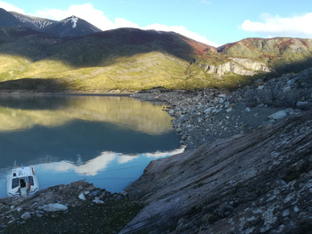
Photograph of the Frías 1 moraine, closing to the south the Brazo Sur (see location of the moraine in Fig. 7).

In this work, the temporal and spatial correlation of the subaqueous morphologies identified using seismic profiles and related to the activity of the Perito Moreno and former Frías glaciers is mostly based on studies of landforms performed by Strelin et al. (Reference Strelin, Denton, Vandergoes, Ninnemann and Putnam2011, Reference Strelin, Kaplan, Vandergoes, Denton and Shaefer2014). The two extreme temporal constraints we have considered to limit the occurrence of the identified moraine bodies are those of the Puerto Bandera 3 moraine and the Frías 1 moraine, which closes off the southern end of the Brazo Sur. Dated samples for spillway M, located to the northeast of Brazo Rico and containing terrestrial macrofossils such as wood, twigs, and moss fragments, yielded a minimum limiting age as old as 12,660 ± 70 cal yr BP (Strelin et al., Reference Strelin, Denton, Vandergoes, Ninnemann and Putnam2011). This represents the oldest age for glacial recession similar to the present-day conditions characterizing Lago Argentino. According to this, the glaciers receded very fast and did not dam Brazo Rico during the Holocene. However, for this general phase of glacial recession, Strelin et al. (Reference Strelin, Kaplan, Vandergoes, Denton and Shaefer2014) report the evidence of a series of advancement phases of the glaciers occurring within the late-glacial period, such as those of 7730–7210 and 6000–5000 cal yr BP. The former could correspond to the formation of one of the post–Puerto Bandera 3 subaqueous moraines that we have identified on seismic profiles.
A large amount of data acquired in the ice fields of the Southern Hemisphere has shown that a phase of warming atmospheric and oceanic temperatures that started ca. 18.0 ka BP was interrupted by a significant episode of cooling—the Antarctic Cold Reversal (ca. 14.7 to 13.0 ka BP)—at the termination of the last ice age (Jouzel et al., Reference Jouzel, Masson-Delmotte, Cattani, Dreyfus, Falourd, Hoffmann and Minster2007; Morgan, Reference Morgan and Gornitz2009; Pedro et al., Reference Pedro, Bostock, Bitz, He, Vandergoes, Steig and Chase2016). A cooling event within a general deglaciation period was also documented in the Northern Hemisphere (i.e., the Younger Dryas stadial), but it occurred in a different time span (ca. 12.7 to 11.5 ka BP; Carlson, Reference Carlson and Elias2013). The reasons for these asynchronous behaviors of the glacial systems between the two hemispheres is the subject of many studies, and many points remain controversial among scholars. Glacial readvances during the Antarctic Cold Reversal have been documented in the tropical sector of the Andean Cordillera (10°S–20°S) (Jomelli et al., Reference Jomelli, Favier, Vuille, Braucher, Martin, Blard and Colose2014), in the Andean region of Torres del Paine (51°S) (Fogwill and Kubik, Reference Fogwill and Kubik2005; García et al., Reference García, Hall, Kaplan, Vega and Strelin2014), and in the Cordillera Darwin of Tierra del Fuego (54°S) (Menounos et al., Reference Menounos, Clague, Osborn, Thompson Davis, Ponce, Goehring and Maurer2013). Divergent evidence comes from paleoclimate studies based mainly on terrestrial records that show either a cooling pattern synchronous with the Younger Dryas stadial (Heusser et al., Reference Heusser, Lowell, Heusser, Hauser, Andersen and Denton1996; Moreno, Reference Moreno2004), a cooling pattern synchronous with the Antarctic Cold Reversal (Lamy et al., Reference Lamy, Kaiser, Ninnemann, Hebbeln, Arz and Stoner2004; Moreno et al., Reference Moreno, Kaplan, François, Villa-Martínez, Moy, Stern and Kubik2009), or an intermediate Younger Dryas stadial/Antarctic Cold Reversal climate signal (Hajdas et al., Reference Hajdas, Bonani, Moreno and Ariztegui2003; Bertrand et al., Reference Bertrand, Castiaux and Juvigné2008; Massaferro et al., Reference Massaferro, Moreno, Denton, Vandergoes and Dieffenbacher-Krall2009). These significant differences between records may be attributed to several factors such as (1) the specific site characteristics, (2) accuracy of the chronological attribution, (3) sampling resolution, and (4) differential influence of the southern westerlies on the two sides of the Andean Cordillera. In addition, attachment of the calving terminus to topographic pinning points may also dampen the glacial response to climate change, causing anomalous recession or advance once the glacier's terminus either recedes behind or advances from such pinning points (Warren and Aniya, Reference Warren and Aniya1999).
These examples show how extremely difficult is to propose a comprehensive glacial evolutionary scheme by analyzing an area quite limited in latitude and substantially homogeneous from a climatic point of view such as the SPI. Identification, mapping, and stratigraphic analysis of sedimentary bodies linked to glacial activity, alongside specific age attributions and chronological relationships, represent the fundamental ingredients for any type of reconstruction of glacial history.
In conclusion, the sequence of moraines identified by the seismic profiles along the two arms of the Lago Argentino, linked by the position and age of the two moraine complexes of Puerto Banderas 3 and Frías 1, allowed us to propose an evolutionary scheme, albeit simplified, of the glacial dynamics of the Perito Moreno and former Frías glaciers for the late-glacial period, as illustrated in Figures 11 and 12.
(color online) Simplified sketch of the glacial fluctuations along the Brazo Rico, derived from the moraine locations and their characterization (letters A to H refer to the glacier's phases individuated).

(color online) Simplified sketch of the glacial fluctuations along the Brazo Sur, derived from the moraine locations and their characterization (letters A to D refer to the glacier's phases individuated).

The approach we have used to discriminate terminal versus recessional moraine on the basis of their acoustic characteristics and internal architecture could be applied in several physiographic contexts to help constrain the glacial dynamics. For example, geomorphological and internal characteristics quite similar to subaqueous moraine systems identified and studied in the two arms of Lago Argentino have been described in southern Chile (Lastras and Dowdeswell, Reference Lastras, Dowdeswell, Dowdeswell, Canals, Jakobsson, Todd, Dowdeswell and Hogan2016), Tierra del Fuego (Waldmann et al., Reference Waldmann, Ariztegui, Anselmetti, Coronato and Austin2010), sub-Antarctic islands (Graham and Hodgson, Reference Graham, Hodgson, Dowdeswell, Canals, Jakobsson, Todd, Dowdeswell and Hogan2016), New Zealand (Barnes et al., Reference Barnes, Pickrill, Bostock, Dlabola, Gorman, Wilson, Dowdeswell, Canals, Jakobsson, Todd, Dowdeswell and Hogan2016), Norwegian (Aarseth et al, Reference Aarseth, Austbø and Risnes1997; Eilertsen et al., Reference Eilertsen, Longva, Corner, Dowdeswell, Canals, Jakobsson, Todd, Dowdeswell and Hogan2016) and Canadian fjords (Shaw, Reference Shaw, Dowdeswell, Canals, Jakobsson, Todd, Dowdeswell and Hogan2016, and references therein), perialpine lakes (i.e., Lake Lucerne; Hilbe et al., Reference Hilbe, Strupler, Hansen, Eilersten, Van Daele, De Batist, Anselmetti, Dowdeswell, Canals, Jakobsson, Todd, Dowdeswell and Hogan2016), Svalbard (e.g., Dowdeswell et al., Reference Dowdeswell, Solheim, Ottesen, Dowdeswell, Canals, Jakobsson, Todd, Dowdeswell and Hogan2016), Iceland (Geirsdóttir et al., Reference Geirsdóttir, Miller, Larsen, Dowdeswell, Canals, Jakobsson, Todd, Dowdeswell and Hogan2016), and nearshore waters in NW Scotland (Bradwell and Stoker, Reference Bradwell, Stoker, Dowdeswell, Canals, Jakobsson, Todd, Dowdeswell and Hogan2016).
We summarize the main findings of this work in the following paragraphs.
We have produced for the first time a complete bathymetric map of the southern arms of Lago Argentino, combining bathymetric soundings and high-resolution seismic profiles.
We have identified several moraine ridges in both the Brazo Rico and Brazo Sur that attest to the occurrence of glacial pulses of the Perito Moreno and former Frías glaciers along these two narrow lake trenches. We have discriminated between terminal moraines and recessional moraines on the basis of the seismic facies of these morphological buildups.
Radiocarbon-dated organic layers from moraine exposures at the eastern end of Brazo Rico (Puerto Bandera 3 moraine) and at the southern termination of the Brazo Sur (Frías 1 moraine) reported in literature have temporally constrained the oldest and youngest events occurring along the two arms of Lago Argentino and pertaining to the Perito Moreno (along Brazo Rico) and former Frías (along Brazo Sur) glaciers. At the confluence between these two lake arms, the two glaciers merged and flowed together for a certain period of time.
The sequence of moraine bodies identified along the two arms of Lago Argentino records the late-glacial history of the Perito Moreno and former Frías glaciers.
This study adds further details to post-LGM Patagonian glacial history, which has been mostly reconstructed by the identification and dating of moraine systems found on land. The information derived from our lake-floor surveys contributes to the overall reconstruction of the glacial fluctuations since ca. 12.0 ka BP. In addition, the presence of submerged moraines identified by seismic and bathymetric data also helps to localize and circumscribe future analysis of deposits linked to the activity of glaciers in specific sectors. In this respect, a specific campaign in the study area is scheduled to verify the presence along the shores of the two arms of the Lago Argentino of the moraine bodies identified in this work. This reconnaissance is aimed at radiocarbon dating any organic samples to produce a more constrained temporal scheme of the latest Pleistocene–Holocene dynamics of the Perito Moreno and former Frías glaciers.
ACKNOWLEDGMENTS
These surveys are part of an Italian–Argentinean scientific project jointly coordinated by the Istituto Nazionale di Oceanografia e di Geofisica Sperimentale (OGS) of Trieste and the Instituto de Geociencias Básicas, Aplicadas y Ambientales (IGeBA) of the University of Buenos Aires. The project is financed by the Italian Ministry of Foreign Affairs and International Cooperation (MAECI); by the Ministerio de Ciencia, Tecnología e Innovación Productiva (MINCYT); and by the Universidad de Buenos Aires. Bathymetric data of the Canal de los Témpanos have been acquired in the frame of the project “Interacción hielo-clima y dinámica de glaciares en la Península Antártica y Patagonia Austral,” coordinated by Pedro Skvarca. We are grateful for the support provided by the crews of the various boats of the Prefectura Naval Argentina that have been used for data acquisition. The authors are deeply grateful for the comments and suggestions from the senior editor, Derek Booth; the associate editor, Thomas Lowell; Jorge Strelin; and an anonymous reviewer who helped improve this work significantly. Seismic data have been uploaded and interpreted using the Kingdom® seismic package. IHS Markit provided the educational license to OGS.