

Introduction
In 2007, the Center for Art and Archaeology (CA&A) of the American Institute of Indian Studies (AIIS) conducted a documentation project that explored an interesting range of built heritage arrayed along a 16th-century highway laid by the Mughal rulers of India. This was among the main arteries of the Mughal period linking their two capital cities – Agra (India) and Lahore (Pakistan) – strategically located the one in the heart of India and the other near the borderland, in the north-western region of the Indian subcontinent. The latter became a part of Pakistan after partition of India in 1947. Well known as the battle ground of the northern plains, this region had always been a politically turbulent yet commercially vital zone due to its geographical location near the significant mountain passes in the north-west that allowed communication between India and Central Asia and resulted in the amalgamation of multiple cultures. The built heritage that survives in this region demonstrates how cultural interactions impacted the creative outcomes and developed a new artistic ethos. The stretch of the Mughal highway this project traced, crossed two north Indian states of independent India – Haryana and Punjab, and documented built heritage that survives on that road. Our journey along the highway revealed edifices unique to a travel environment including Caravan sarai (rest house), Kos-Minars (distance markers), bridges, stepped-wells and Bagh (pleasure gardens) built under the patronage of Mughal elites.
The Organization
The CA&A was established in 1965 by a group of art historians specializing in South Asia who felt the need for a visual resource in India to facilitate research in the field. The founders built a photo-archive by creating documentation of monuments and antiquities from South Asia with a focus on the Indian subcontinent. Collections were further enriched with photographs received as donations from other researchers. The documentation made by the CA&A researchers and the documentation team was motivated by scholarly questions and resulted in projects as large as the Encyclopaedia of Indian temple architecture that set the stage for the creation of the biggest photo-archive on ancient Indian art and architecture. Documentation produced meticulous coverage of historical buildings and related antiquities covering a period spanning more than 2000 years, since 3rd-century BC to the 20th-century AD. All architecture types, such as rock-cut and built structures, affiliated with Hindu, Buddhist, Jain, Christian and Islamic cultures were documented. The visual materials collected through this project were reproduced in 14 volumes of the Encyclopaedia of Indian temple architecture, the magnum opus of the CA&A.
An internationally recognized presence in the documentation of Indic and South East Asian art and architecture, the Center has a collection of well over 200,000 images covering photographic records and architectural plans of more than 7000 monuments and ancient buildings in its archives. Archaeological and historical sites numbering to the tune of 3000, and over 350 museums are represented in the Photo-archives of the Center. The AIIS surveyors and draftsmen have drawn some 6000 detailed, measured architectural drawings and sketches of monuments, several of them never drawn before, based on their on-the-spot surveys and measurements. The documentation project of built heritage in the Agra – Lahore highway region that is under discussion was undertaken with the perspective to identify and document the surviving architectural wealth and enrich the CA&A's existing visual resource on Indo-Islamic architecture. The project also aimed to shed light on the built heritage of this region which had hardly drawn attention compared to the ones located in major Mughal cities like Delhi and Agra, despite the fact that some of the surviving monuments in this region were built by Mughal rulers, the dynasty best known for the creation of the Taj Mahal. A generous grant from the U.S. Ambassador's Fund for Cultural Preservation made the project possible.
Mapping the Highway
I led a documentation team consisting of two photographers and two draftsmen to carry out photographic and architectural documentation. Under the guidance of CA&A's former Chairs, Catherine B. Asher, a scholar of Indo-Islamic art & architecture, and Janice Leoshko, art historian, we identified about forty-five sites in Haryana and Punjab, situated along Agra – Lahore highway, which is also popularly known even today as the Grand Trunk Road (GT Road), indicating its link to the British, who were credited for reinforcement of this highway in the 19th century. A contemporary account mentions how this route was extended and also diverted at certain places in view of developing a modern road between Agra-Lahore.Footnote 1 The importance of this highway in current times is also evident from the fact that this route was officially renamed as National Highway 1 after independence 1947.Footnote 2 The sites chosen for the documentation project, however, existed along the old route that merged with the GT Road/NH1 for about 270 miles between our starting point Palwal (Haryana) to Phillaur (Punjab), after which it diverted and took a separate direction from the NH 1; it ended at Raja Taal, named after the tank (Taal) built by a Mughal nobleman and King (Raja) in the modern State of Punjab, the last site located in India at India-Pakistan border included in our list. A tank is a reservoir constructed for water storage all across the Indian subcontinent, and was often built in temple complexes.
We used the help of earlier inventories and old accounts that were mostly available in our library, to select the sites. While the Agra – Lahore highway and the monuments placed along the route were often mentioned in the Mughal accounts including the ones recorded by the Emperor Jahangir in his memoirs, the official inventories were created by the Archaeological Survey of India from mid 19th century onwards, which listed almost every rest house, distance marker and bridge found in the region.Footnote 3 Mughal Emperor Jahangir writes how he ordered for trees to be planted for shade and rest houses to be built along the travel routes to facilitate the caravans (traveler groups),Footnote 4 and he also specifically mentioned monuments like Sarai Nurmahal (1618 CE) constructed by his wife the Empress Nurjahan, after whom the rest house (Sarai) was named.Footnote 5 Mughal accounts record Jahangir's order of 1607 in which he instructed landowners living in the vicinity of the Agra – Lahore highway to construct Sarai at the distance of every eight kos (a distance measuring unit) in durable materials such as brick or stone and also emphasized the need to maintain them in good condition.Footnote 6 What rest houses we find today are not all the ones which might have been constructed during Jahangir's time but remains of so many of them on the Agra – Lahore route certainly prove that even after Jahangir the later Mughal rulers took an interest in building rest houses. Contemporary European travelers also gave accounts of their travels via the Agra-Lahore travel route that was lined-up with rest houses and distance markers.Footnote 7
Monuments were selected based on their importance as a significant unit of the chain of amenities such as rest houses, step-wells, distance markers, public baths, bridges and gardens for the highway travelers created by the Mughal emperors and their officials in the 16th and 17th centuries. Photographic and architectural documentation of 15 Caravanserais (rest houses) located in Haryana starting from Palwal (Sarai Pukhta 1611-1615), Faridabad (Sarai Khwaja 1671-1672), Gharunda (Mughal Sarai 1628-1658), Tarawadi (Mughal Sarai 1658-1707), Thanesar (Sarai 1650), Sahabad (Killa Sikkhan 1600-1626), and in Punjab Shambhu (Sarai Shambhu 1605-1627), Rajpura (1639-1665), Kot Panech (Sarai Lashkari Khan (1669-1670), Doraha (Sarai Doraha 1606-1611), Nurmahal (Sarai Nurmahal 1618), Sultanpur-Lodi (Sarai 1628-1660), Mahlian Kalan (Sarai Dakhni 1628-1660), Fatehabad (Mughal Sarai 1606-1660), Amanat Khan (Sarai Amanat Khan 1640-1641) was carried out. Rest houses were one of the most significant forms of built heritage in this region that were erected for halting of caravans. They facilitated the travelers and traders as a place for halting, resting and also as the nucleus of myriad activities, including trade. The rest houses we documented were mostly built in brick as fortified structures, due to their location in secluded countryside and their function to provide secure accommodation to caravans. Inside the enclosure, on all four sides rows of rooms were constructed for travelers that would open to the inner courtyard. These would essentially have a mosque for prayers, a well for drinking water and the large ones used to have Hammam (bathhouse) for freshening up. Rest houses were approached through two giant gateways designed to allow access to large caravans mounted on camels and elephants. Having two gateways was typical of the Mughal rest houses that would be oriented towards the capital cities of Agra/Delhi and Lahore. The gateways used to be three to four stories, containing comfortable rooms of varied sizes for all levels of the rest house managers, guards and other staff members. The balconies at the upper levels not only provided a strategic post for guards of the rest house but also served as ornamentation for the Gateways.
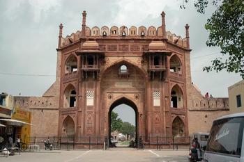
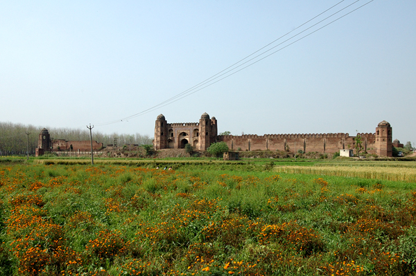
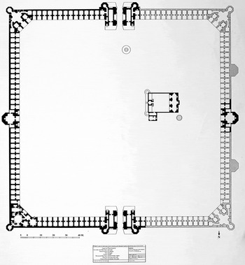
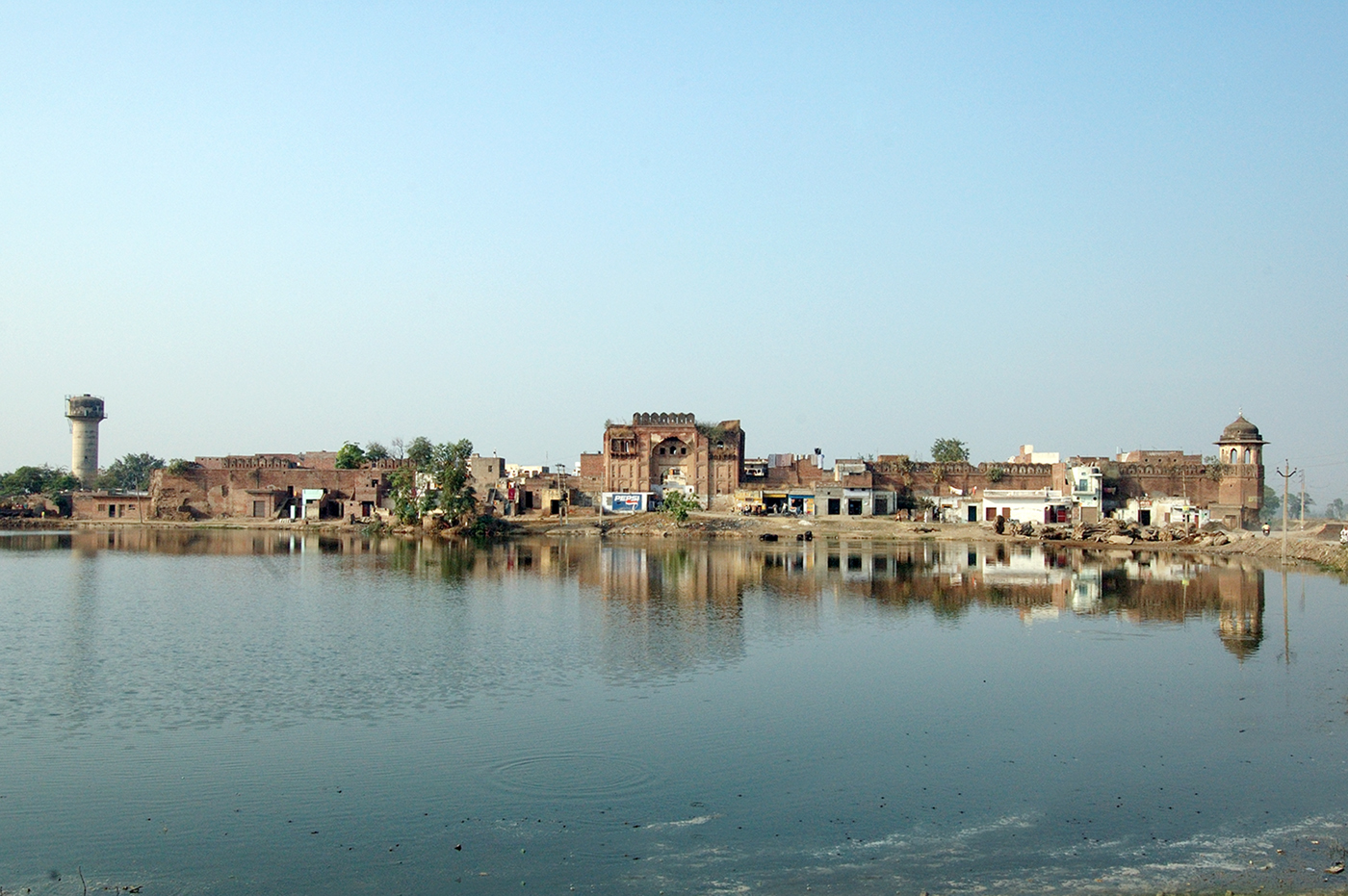
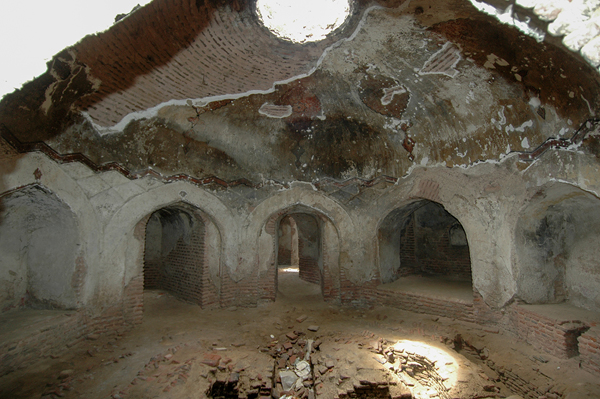
It was interesting to see as how many of these rest houses now were being reused for different purposes, the most common being residential societies for the migrants who found asylum in these rest houses after moving to India from Pakistan post Partition, in 1947. While rest houses in Palwal (Haryana), Faridabad (Haryana) and Fatehabad (Punjab) were taken over by newly constructed houses and shops leaving traces of fragmented walls or rooms visible here and there, many rest houses were also well preserved by state and central government authorities. The rest house buildings in Tarawadi (Haryana), Rajpura (Punjab) and Sahabad (Haryana) had maintained their fortified exterior but the inner courtyard and rooms were fully inhabited by the refugees. While the rooms for travelers served as single room flats for them, the bigger corner rooms and the guards quarters built in the gateways were used for temples, offices or bigger living spaces. The best-preserved rest houses were those that were affiliated with royal or elite patronage such as Sarai Nurmahal (Fig. 1), Doraha (Fig. 2), Dakhni, Shambhu and Amanat Khan, all in Punjab. The rest house at Gharunda (Haryana) was demolished by the British during the revolt of 1857 with a view to dislodging some of the mutineers.Footnote 8 What survives today are the two gateways that exhibit vestiges of the original grandeur of the rest house. The bathhouses, known commonly as Hammam have survived inside Sarai Doraha (Fig. 3) and Sarai Nurmahal, built for providing the travelers and other visitors, a refreshing place either for a hot steam or soothing cold-water bath. Many modern towns such as Doraha and Nurmahal where these rest houses were built derive their names from the rest houses themselves, such was the grandeur and popularity of these structures.
Façade of Sarai Nurmahal, Jalandhar, Punjab, India, Photo: AIIS

Sarai Doraha, Façade from Delhi Gate side, Ludhiana, Punjab, India, Photo: AIIS

Floor plan of Sarai Doraha that contains a bath house in the northeast corner, Ludhiana, Punjab, India, Drawing: AIIS

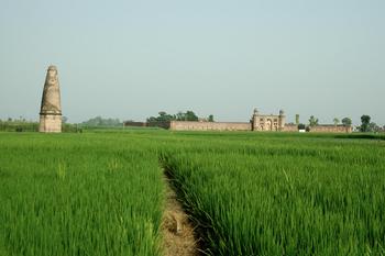
Contemporary and later travelogues record that rest houses built on the highway were punctuated by distance-marker pillars or kos minars, marking each kos (unit of distance measurement) from Agra to Lahore.Footnote 9 The distance between two distance-marker pillars was measured to be about 2.1 to 2.4 km.Footnote 10 Since on an average day a caravan was expected to travel about 12 miles (approximately 19 km), there would be, generally, 8 distance-markers between two rest houses.Footnote 11 As many distance-marker pillars still survive, they made it easy for us to get an idea of their placement along the route. Also, we often noted distance marker pillars placed near rest houses, such as in Faridabad where Sarai Khwaja had become almost a ruin, leaving nothing but a few rooms and fragments of the enclosure wall, but a distance-marker survived right there; near Sarai Lashkari Khan and Sarai Dakhni also distance-marker pillars survive. Over the course of time, with later restorations of the old route, the relevance of Mughal distance-markers was lost and they became disconnected from the highway (Fig. 4). As a result, those either perished or survived as insignificant entities in the contexts of later trade and travel corridors. During our documentation we found them popping up from within houses, agricultural fields and also at times standing in isolation on the National Highway 1 (Fig. 5).
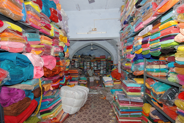
Extant remains of a Sarai room at Palwal, Haryana, India, being used as a cloth shop. The Sarai building is densely populated and houses a local market as well as residential quarters, Photo: AIIS

Fortified structure of Mughal Sarai and Tank at Tarawadi, Karnal, Haryana, India, which is currently occupied by the partition refugees. Photo: AIIS

In addition to rest houses and distance markers, a large variety of contemporaneous building types including bridges, stepped wells, tanks, pleasure gardens, mosques, Muslim religious shrines, and tombs were documented from the Agra-Lahore travel route, and from nearby regions such as Batala and Kalanaur in Gurdaspur District (Punjab), which have some very important monuments built during the Mughal Emperor Akbar's reign in the second half of the 16th century or early 17th century (Fig. 6).
Hammam in northwest corner of Sarai Doraha, Ludhiana, Punjab, India, Photo: AIIS

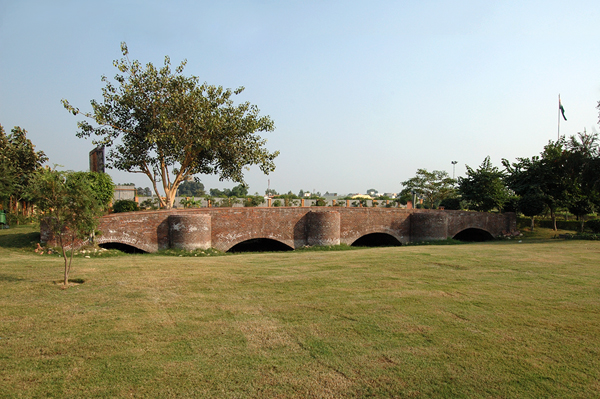
Many bridges built by the Mughals when improving the Agra – Lahore road survive and could be identified through their heavy pillars erected to support the pathway and the arched openings. Some that we documented are still functional, such as from Faridabad (Haryana), built over a stream converted to a sewage drain now; the bridge, however, is still in use by pedestrians and two-wheeled vehicles. It was located about half a kilometer away from Sarai Khwaja a near-derelict Mughal rest house (Fig. 7). Nevertheless, the area is known even today by the Sarai's name. The route of the bridges found by our team were flanked by minars (pillars). In addition to the functional bridges, there were some that were adapted and repurposed into new landscapes such as the one in Thanesar (Kurukshetra, Haryana) (Fig. 8). A recently constructed Millennium Park on this land transformed it into a low Japanese garden bridge to make it a part of the garden theme.
Kos minar near Sarai Dakhni, Mahlian Kalan, Jalandhar, Punjab, India, Photo: AIIS

Mughal Bridge at Thanesar, Kurukshetra, Haryana, India reused in a modern park, Photo: AIIS

Building multi-storied step-wells (Baoli) especially in arid regions of the subcontinent was a common practice even before Muslims arrived in India. Mostly placed on travel routes, these not only served to quench thirst of the travelers, the spaces created several levels below the surface of these elaborate wells provided cool resting places.Footnote 12 Besides a well, there were additional tanks for bathing and washing purposes. A Mughal Emperor ordered wells to be dug at every third post (distance-marker pillar) ‘so that the wayfarers could travel easily and comfortably and not suffer from thirst or the heat of the sun.’Footnote 13 We found two step-wells, one near Sarai Doraha and the other near Sarai Amanath Khan, which were in dilapidated conditions - the one near Doraha was owned by a farmer and utilized to water the fields, whereas the one near Amanat Khan was in state of ruin.
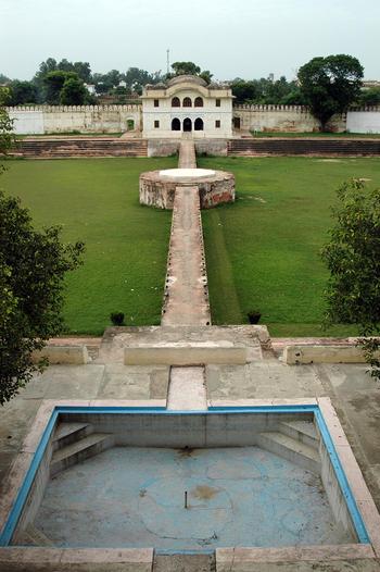
Gardens were especially mentioned by Mughal rulers, and they encouraged the creation of such throughout their empire. One of the famous and most extensive Mughal Gardens constructed for royal caravans on the Agra – Lahore highway was the Aam Khas Bagh (1580-1658) in Sirhind. It is also very often mentioned in Mughal chronicles recording visits by most Emperors including Akbar, Jahangir and Shahjahan who not only patronized construction of several wings, they supported maintenance of the garden on regular basis.Footnote 14 Mughal Emperor Shahjahan had a large tank excavated within the garden and built a palace along its bank as a summer retreat.Footnote 15 The garden also had bath houses for hot and cold baths, in addition to royal apartments added for the royal retinue's stopover. Our documentation team photographed and created measured drawings of the bath structures (Fig. 9).
Shish Mahal, balustrade bridge and rectangular tank with a fountainhead, Sirhind, Fatehgarh Saheb, Punjab, India, Photo: AIIS

Some of the other gardens include Kabuli Bagh (garden) and mosque (1527-1528), the first we were able to document, was built in Panipat (Haryana) under the patronage of the first Mughal Emperor Babur. The garden must have been laid out on the model of the gardens of Samarkand, some remains of which survive around the mosque.Footnote 16 Traces of an elaborate tomb garden Hazironwala Bagh were found in Nakodar, a gateway and the tombs of Haji Jamal (1656-1657) and Muhammad Mumin al-Husayni (1612-1613) survive today.Footnote 17 Jahangir made mention of the garden at Kalanaur (Gurdaspur, Punjab) and the site of Akbar's coronation in his memoirs ‘On Wednesday, the 2nd of the Divine month of Bahman, the garden of Kalanaur was honoured by my halting there. At this place my father has ascended the throne (1556 CE).’Footnote 18 No garden however exists at Kalanaur today but farmers report that when they work in the fields here, they still encounter the remains of the water channels that once shaped and irrigated this Mughal garden.
During exploration of the Agra – Lahore Mughal highway, we saw buildings such as mosques and tombs, which had been abandoned in 1947 as the Muslims of Punjab (now divided into the states of Haryana and Punjab) migrated to the new nation state of Pakistan. Some of these buildings have now been transformed into Sikh Gurdwaras and Hindu temples, for example the Durga Mandir in Sonipat that was originally conceived as a mosque.Footnote 19
Community Engagement
We surveyed a variety of audiences visiting the sites with question about their understanding of these monuments while we were documenting them. We also gave them information about our documentation efforts. In many cases we realized that people actually didn't know the functions of these ancient structures, nevertheless there was a great deal of curiosity and in many cases a sense of belongingness that made them conscious about the preservation of structures. For instance, most of the residents living in the rest houses didn't know for what purpose these spaces were created; in their understanding, based on the fort-like appearance of the rest houses, these were forts built by illustrious historical rulers who ruled in that region. In an interview with the residents at Sarai Tarawadi, they told us that the ‘fort’ was built by the great Rajput ruler Prithviraj Chauhan who ruled in Delhi in 12th century, and this information was published in their history books (for which we found no reference). In fact, the rest houses could be located in this region only if they were mentioned as a ‘Kila’ (a fort). Often, the local communities acknowledged the Agra – Lahore highway as the G. T. Road or “Sher Shah Suri Marg (road)”, an earlier route constructed by the Afghan ruler Sher Shah Suri between Kolkata and Peshawar; the sign boards also often displayed the popular names as mentioned above. At the same time, many visitors from local communities also demonstrated a high level of awareness and aesthetic sensibility about the monuments in their neighborhood during many of our on-site discussions. That could have been the reason for sincere upkeep of monuments like the Durga Mandir (Jami – Mosque) in Sonepat (Haryana), and its beautiful ceiling painting which is cared for by private owners. During our interactions, an active interest by communities, tourists and the general public about these monuments was noted. These field observations and interactions with the people-at-large made us believe that such programs do help create awareness and generate more interest in the cultural heritage of the geographic area that we document and study.
Conclusion
The crucial preliminary fieldwork including photography and architectural mapping of the monuments was completed at the sites, and the extensive data and raw images were developed into finished documents in the Center's premises. In between various phases of field documentation, the information collected from the documentation of monuments was entered in the database, further research was carried out to gather information about the monuments and inscriptions, editing of images and the completion of drawings was undertaken. The entire material created through this project that included detailed measurements and ground plans, site plans and maps, was put on the web at https://www.vmis.in for worldwide access.
Post documentation, we organized a formal exhibition of the documentation collected for viewing by the general public. All the documentation team members worked intensively for many weeks to put together the exhibition that detailed the documentation procedures followed by the CA&A team members, as well as high-quality photographs and architectural documentation of the monuments that we created. The exhibition was used to further engage local communities and school children to educate them about this significant 16th century Mughal highway and its built environment. This endeavor also aimed at drawing interest, especially of the students towards this material and encourage them to use and evaluate documents of primary evidence of the past.
The project emphasized the importance of identifying the strands of cultural heritage and the processes of documenting them. It highlighted the value of continuing to look for traces of the past, while on other fronts developing an awareness of the past. A major aim of such documentation was to aid preservation of the monuments themselves by providing critical information for future decisions. The project also underscored the importance of understanding the layers of the ‘landscape’ in which communities live. Further knowledge of these monuments created through this effort allowed reflection on the shared nature of the Indo-Islamic traditions in South Asia that have been diminished or lost due to time.
This is an edited version of a paper delivered at the WLIC Art Libraries Section in Kuala Lumpur, August 2018.