Introduction
El Hamdania is a small town located about 100 kilometres west of the Algerian capital Algiers and approximately 6 kilometres east of the modern city of Cherchell. The varied coastline surrounding the town, perched on the shores of the Mediterranean, offers a rich contrast of steep cliffs and sandy or pebble beaches. Today, much of this coast is shaped by urban development. In antiquity, in contrast, El Hamdania and its hinterlands were essentially rural in character, as the presence of numerous remains of farms and fish farms suggests. For example, the site of Trois IlotsFootnote 1 at Amesfout Cape holds a substantial concentration of archaeological features which will be discussed further below. The high number of remains here indicate that this area was important in antiquity, most likely because of its proximity to Caesarea, the capital of the Mauritanian kingdom.
In 2018, the construction of a commercial mega port at the town of El Hamdania was proposed. This port would be the largest commercial port in Algeria, covering an area of 464 ha. It soon became clear that the proposed area would include more than six known archaeological sites. However, many of the sites in this area had not yet been fully documented at the time of the port-project proposal. It was, therefore, of primary importance to identify and record the coastal and submerged sites that may be affected. This paper will present the results of archaeological surveys undertaken in the proposed port area (on land and underwater). Furthermore, it will consider the effect the port construction might have on both the cultural heritage and on the geomorphology of the region.
Geographical, geomorphological and historical context of the area of El Hamdania
Geographical and geomorphological overview
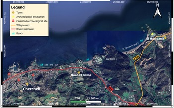
The coastal town of El Hamdania is located in northern Algeria in the Wilaya of Tipasa (ancient Tipasa) about 8 km east of the city of Cherchell (ancient Caesarea) (Figure 1). El Hamdania is reached via the coastal Wilaya road (W109) that links the town of Tipaza with Cherchell. The road passes through the northern slope of the Chenoua massif and joins the National Road (N11) 2 km to the west of the city of Ben Kheira. The coast of Cherchell is characterised by its varied landscapes, including plains, mountains and the sea, thus offering a rich biodiversity which, judging by the distribution of archaeological remains within, has seduced people since prehistoric times (Marchand Reference Marchand1932, 478–80).
Geographical map of El Hamdania (image: B. Donia; base map: © 2021 Maxar).

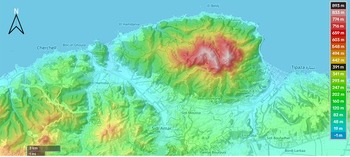
The region of El Hamdania extends over 6 km between Trois Ilots in the east (36°62′59.45″N and 2°26′40.05″E) and Cape Riadh in the west. To provide a broader view of the geomorphology, we extended our study area further west to Cape Tizirine, thus also including Cape Rocher Blanc and Oued El Bellaa (36°62′59.45″N, 2°26′40.05″E) (Figure 2). The area is defined by two morphological landscapes, a coastal plain and valleys formed of alluvial terraces, which are an extension of the plains of Mitidja (Amrani et al. Reference Amrani, Fernane, Naili, Ryhane and Belkessa2021, 57; Leveau Reference Leveau1984, 217). To the north, the landscape is dominated by the western Algiers’ Sahel. The Chenoua massif borders the Sahel, reaching up to 904 m in height, thus providing protection from the easterly winds. The Chenoua massif is separated from the Chelifian Dahra by two valleys and is bordered by the mountains of the Cherchallian Atlas, which runs in terraces parallel to the coast, rising to a height of 500 m. Here, the forest of Beni Hbiba flourishes (Leveau Reference Leveau1984, 219). Two valleys cross the area of El Hamdania, their slopes extending into the hinterland. The eastern watershed is that of Oued El Hachem. Its elongated rectangular shape covers an area of 219 km2 with a perimeter of 82 km (Abaidia and Remini Reference Abaidia and Remini2020, 136). Meanwhile the western slope of Oued El Bellaa covers an area of 55 km2, with a perimeter of 38 km. The area is characterised by its mountainous nature with a maximum height of 736 m (Elahcene et al. Reference Elahcene, Terfous, Remini, Ghenaim and Poulet2013, 225).
Topographic map of the east Cherchell region, including the area of El Hamdania (image: http://fr-fr.topographic-map.com and for copyright https://fr-fr.topographic-map.com/legal/.

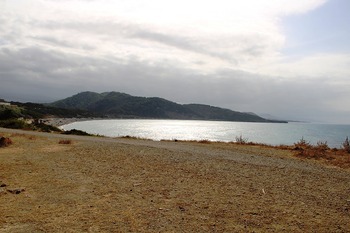
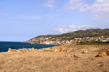
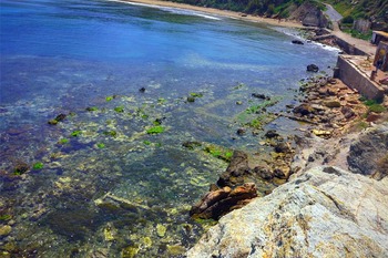
There are three types of coastal morphology present in this area: rocky coastlines, cliffs and sandy beaches (Figure 3 and Figure 4). Towards the east of the study area the slopes of the Chenoua massif drop abruptly into the sea and erosion has formed a fragmented and sharp rocky coastline. At Trois Ilots the rocky beach is 1500 m in length and at Oued El Bellaa it is 400 m in length. At Cape Rocher Blanc a rock-cut cliff rises to 40 m in height, while the cliff at Cape Riadh only rises to 10 m (Amrani et al. Reference Amrani, Fernane, Naili, Ryhane and Belkessa2021, 551). The coast meets the sea at two low valleys (Abaidia and Remini, Reference Abaidia and Remini2020 136): the Fedjana valley leads to the 2-km-long medium sandy beach of El Hamdania; further west, the Boukadir valley shelters the Oued El Bellaa, which originates 20 km upstream at the confluence of several small rivers. The mouth of Oued El Bellaa is located at a beach of the same name, stretching 450 m in length (Amrani et al. Reference Amrani, Fernane, Naili, Ryhane and Belkessa2021, 552).
View of Hamdania beach from Cape Amesfout (image: R. Khellaf).

View of the western rocky coast of the area from Cape Amesfout (image: R. Khellaf).

Historical overview
The coastline of Cherchell contains evidence for human occupation beginning in prehistoric times. At Cape Amesfout, sites rich in pedunculated Mousterian points made of quartz sandstone suggest the production of lithics in an area of over 2 km. Furthermore, flint tools predominantly from the Neolithic period are very abundant at Cape Rocher Blanc. The raw materials needed for their production come from the adjoining valleys (Marchand Reference Marchand1932, 477–80).
The Libyco-Punic period (from the fifth century BC onwards) played a significant role in the history of the Cherchell region, as it saw the establishment of a Carthaginian trading post. Contact between the native inhabitants and Carthaginian navigators led to the foundation of the city of Iol (modern Cherchell). Iol first belonged to the Masaesyli and was later incorporated into the Numidian kingdom. Pseudo-Scylax calls the city ‘Iouliou’ mentioning the location of the polis and the port on a promontory ‘Ίουλίου αχρα, πὀλιςχαἱλιμἡν’ (Müller Reference Müller1855, 90). Following the capture and death of King Jugurtha, the city and its territory passed to the Mauritanian kingdom in 105 BC (Sallust, The War with Jugurtha).
The short period preceding the annexation to the Roman Empire between 25 BC and AD 42 is marked by the reign of King Juba II and his son Ptolemy who was assassinated in 40 AD. Iol became the capital of the Mauritanian Kingdom in 25 BC when it was renamed Caesarea. During this period the area of El Hamdania experienced some activity, but its exact nature is difficult to determine. Excavations on the site of the Trois Ilots have revealed archaeological levels from the first century AD, including the discovery of three pottery marks indicating that the pottery was imported (Dorbane and Filah Reference Dorbane and Filah2018).
During the reign of the emperor Claudius the town was elevated to the rank of colony, changing its name to Colonia Claudia Caesarea. The area around Cherchell flourished until Late Antiquity, with various hydraulic installations, industrial buildings, Villae Rusticae and Villae Maritimae being scattered within the city's territory (Leveau Reference Leveau1984, 304). According to Procopius, Caesarea remained under Roman rule in the Byzantine period, while the rest of the region was ruled by local authorities: ‘Caesarea is the capital of the second Mauritania, occupied by Mastigas and his Moors. This whole province is subject to this Moorish chief and pays him tribute, except for the city of Caesarea (…) The Romans communicate by sea with this capital [Caesarea]; but they cannot get there by land’ (Procopius, Vandal Wars, II, 20).
During the Islamic period, Caesarea received its current name, Cherchell (Bouchama Reference Bouchama2008, 112–13). The earliest evidence takes us back to the Fatimid period with the remains of a Mihrab. During the Hammadite period, the port of Cherchell (as well as the port of Béjaia) had strong trade connections with Andalusia (Bourouiba Reference Bourouiba1977, 129). With the fall of Granada in 1492, several Andalusian families settled in the town of Cherchell. They became involved in agriculture and in the manufacturing of silk and ships. Mármol Carvajal tells us that at two places to the east of the city, the Moors were rich and on good terms with the Turks and they offered Barbarossa a port (Reference Mármol Carvajal1667, 393).
The city was conquered by the French Marshal Vallé in 1840 (Gsell Reference Gsell1926, 26). Agricultural villages flourished in the region (Beghdadi-Rebahi Reference Beghdadi-Rebahi2017, 8) and the plains of Les Trois Ilots and Oued El Bellaa were dominated by the hill of Saint-Dominque. In 1962, Cherchell was annexed to the Wilaya of Tipasa, and villages were established along the coast that soon joined the ranks of communes of the Wilaya.
Research history
Very few archaeological studies have been undertaken in the area of El Hamdania. In 1892 Count Lauer reported the discovery of two lead sarcophagi in his property on Rocher Blanc Cape (Leveau Reference Leveau1984, 248). Gsell reports the presence of archaeological remains on either side of Oued El Bellaa, numbered respectively 19, 20 and 21 on the Cherchell map of his archaeological atlas of Algeria (Gsell Reference Gsell1911). The remains of the Trois Ilots were studied in 1955. The report of the excavations mentions a villa rustica, around which a cluster of evidence for later occupation was present, representing communities that sustained their livelihood from the sea and agriculture (Lassus Reference Lassus1956, 164–68).
Leveau (Reference Leveau1984) carried out essential documentation work in the study of the former royal capital. He located and documented all the archaeological traces appearing in the rural area around Cherchell. From 2013 onwards, the Trois Ilots site became an educational archaeological site directed by Prof. Dorbane and Prof. Filam, from the Laboratory of Archaeology, Heritage and Archaeometry, affiliated with the University of Algiers 2.
The El Hamdania field survey 2018 – methodology
In 2018 the Algerian government decided to build the largest port in Algeria (and North Africa) and chose the site of El Hamdania to implement this project. Environmental impact studies were carried out by the Maritime Study Laboratory (LEM 2016). However, this study did not take the archaeological remains into consideration. It should be noted that there is not yet an obligation to carry out preventative work, prospecting or excavations in Algeria before the start of major development projects. The cultural services, nevertheless, intervened to express their opinions on the impact of the port construction on the archaeological sites. The port plans were modified initially because they encroached on the site of the Trois Ilots. From 2018 onwards, terrestrial and underwater archaeological surveys were carried out over the entire area of the future port site. This mission was entrusted to the Centre National de Recherche en Archéologie (CNRA). Two teams were formed, the first focusing on terrestrial and the second on underwater sites (CNRA 2019). The purpose of this operation was to assess the archaeological potential of the future port site and to record all the data relating to the remains in order to help decision-making about the planning and construction of the port (Khellaf et al. Reference Khellaf, Bensalah, Bensaidani, Maalam, Benaouda and Magha2020). Most of the work carried out consisted of field and underwater surveys. Our goal was to locate, document (photo, sketch), analyse and report the sites in a non-intrusive and non-exhaustive manner. The team in charge of the terrestrial part of the survey carried out targeted field operations, including the known sites listed in Gsell's Atlas Archéologique de l'Algérie (1911) and Leveau's map (1984). Other sites reported by the current inhabitants of the regions have also been recorded.
For the underwater survey three stages of survey work were necessary: first, the extended survey of the site; second, the delimitation of the sites where the remains were concentrated; and third, taking into consideration all the aspects of study (photography, various surveys of the site and inventory, and other technical constraints, etc.). To complete stage one, the underwater survey was carried out with a sounder that was equipped with Clearvu and Sidvu technology. These tools offer a near-photographic quality image of the bottom of the ocean, enabling us to obtain detailed imagery from below the water surface on each side of the boat, with the aim to find anomalies and document them. In addition, a detailed bathymetric map of the whole area with an accuracy of 30 cm was produced to understand the context of the possible remains found in situ and to identify anomalies on the sandy bottom (such as tumuli), which could indicate the presence of submerged remains.
For stage two, we opted for the visual prospecting technique by corridor where the area to be investigated was narrow. This system relies on a chain of two to six divers who have a long tape measure or graduated line at equal intervals paced between them, depending on the limit of visibility. The search was undertaken with a bottom line to guide a controller that the other divers followed. The presence of an object was signalled and recorded from the two baselines. In preparation for stage three, the surveyed site was marked out and areas with high archaeological potential were delimited by using visible elements on the water surface. As a next step, a grid was set up and each beacon was georeferenced. The readings taken under water were based on the beacons and the bottom line. Drawbacks of the underwater survey included limited human resources and a narrow ocean floor that did not allow for the presence of many divers in order to maintain optimal visibility. However, the shallow depth (between 3 m and 5 m), allowed the team to stay under water for longer.
Assessment of the archaeological work
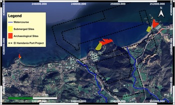
The results of the archaeological surveys carried out between 2018 and 2021 have made it possible to identify and document several sites, which were located on the coastal strip from El Hamdania to Tizirine Cape (Figure 8).
The site of Trois Ilots:
The villa
Excavation reports from previous investigations concluded that Cape Amesfout was occupied for a long period of time, from the first century BC to the sixth century AD. At the centre of the cape was a large peristyle villa (1800 m2) arranged around a cruciform basin of very neat construction, with a fountain in the middle. It served two large underground cisterns to the north and two salting basins at the western corner (Dorbane and Filah Reference Dorbane and Filah2018). The northern part of the villa was devoted to agricultural activities (Leveau Reference Leveau1984, 248–53). The 2018 excavation campaign led to the discovery of a building with four basins dedicated to fish salting. This discovery indicates significant industrial exploitation at the site in addition to the two previously discovered basins at this villa. The north of the Cape is marked by a Christian Basilica, which is 26 m long and 16 m wide. It is divided into three naves and the floor was paved with mosaics, now on display at the open-air museum of Cherchell (Dorbane and Filah Reference Dorbane and Filah2018).
The Necropolis
Several tombs are visible along the W109 road adjoining the Trois Ilots site, marking the limits of the ancient settlement area. These tombs were discovered during the construction of the road leading to the village of El Hamdania, to the south-west of the site of Trois Ilots. The tombs are constructed of stone slabs, some were lined with lime mortar. They are oriented east–west and are of indeterminate age (Leveau Reference Leveau1984, 252).
The wreck of the Trois Ilots
Spotted by an amateur diver in 2021, a wreck carrying cut stones was discovered in shallow depth next to the site of Trois Ilots, at coordinates 36°37′28.45″N 2°15′37.91″E. Our survey revealed a wreck that was about 18 m long and 8 m wide, carrying more than 100 cut-stone elements of various shapes and sizes that had the characteristics of ancient blocks. However, a pulley found on the wreck bears traces of a mechanical saw, which leaves us sceptical about the dating of the wreck to the Classical period. More investigations are needed to determine the age of the ship and its load.
Cape of Rocher Blanc
The Rocher Blanc Cape site, formed of white limestone, is located 5 km east of the town of Cherchell.
The villa
Almost no traces of this villa reported by Leveau are visible on the surface (Leveau Reference Leveau1984, 248). A few centimetres of soil were cleared to be able to appreciate the arrangement of two freestone walls whose limits have not been established.
The wreck
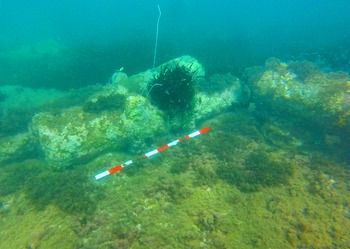
What we report as a wreck here is, in fact, a group of cannons that are submerged between 3 m and 5 m in the middle of the bay of Rocher Blanc Cape (Figure 5). They were reported in the 1990s by a local association who investigated them. Unfortunately, the results of this investigation are not published. During the first preventive campaign in 2018, this group of cannons was documented with the help of photogrammetry and the study was published in 2020 (Khellaf et al. Reference Khellaf, Bensalah, Bensaidani, Maalam, Benaouda and Magha2020). The wreck dates to the sixteenth century AD, based on a cannonball found on the site. The 23 cannons, all of which are of the same dimensions (2.40 m in length and 40 cm in width), are grouped together in the same space, but oriented differently. We did not find any trace of the shipwreck itself. Consequently, we conclude that the guns were dropped during a disaster.
Group of cannons, submerged between 3 m and 5 m at Rocher Blanc Cape bay (image: R. Khellaf).

Tizirine
Tizirine Cape is located at the eastern entrance to the town of Cherchell, stretching to the western end of Tizirine beach. This is the site of an ancient domus, which has industrial features such as salting ponds and a fishpond associated with it. The latter was studied and documented in 1968 by Yorke and Davidson (Yorke and Davidson Reference Yorke and Davidson1969), but their plan remained incomplete. A re-investigation of the tanks enabled us to identify new structures and redraw their plan (Khellaf and Bensalah Reference Khellaf and Bensalah2019). Four salting ponds were built directly on the ground (Figure 6). Their construction technique places them in the third century AD, but it is impossible to confirm that the basin and the seven fishponds were constructed at the same time, as they have no apparent trace of a strainer. Because of this, we are unable to assess the relative changes in sea level.
A group of tanks at Tirzine Cape that were part of a Roman-period domus (image: R. Khellaf).

The El Hamdania port project
The construction of a commercial port at el Hamdania is part of a long-term development vision for the commercial and industrial sectors in Algeria with a Mediterranean and continental scope. The construction cost, estimated to be between five and six billion dollars, will be financed by a loan from the National Investment Fund (FNI) and a loan from the Chinese bank, Exim – Bank of China (Hadjib, Reference Hadjib2022).
The port building project was concretised by the executive decree N°. 17-122 of the 23 Joumada 1438, on March 22, 2017 (Journal officiel 2017, 7–8). This was modified and supplemented by the executive decree N°18-68 of Joumada El Oula 1439, February 23, 2018 (Journal officiel 2018, 3). The port covers an area of 464 ha, of which 288.30 ha are on the national forest estate. It will be equipped with 24 quays with a length of 6320 m and the draft will be 20 m (Journal officiel 2017, 7). This project will also include the construction of a motorway service with a footprint of 367.47 ha, including its various infrastructures, as well as the construction of a 38.6 km railway line linking the port to El Afroun. An industrial zone of 2000 ha, equipped with its various networks and public utilities, will be constructed by exploiting the hill overhanging the beach of El Hamdania and its surroundings (Journal officiel 2018, 3) (Figure 7).
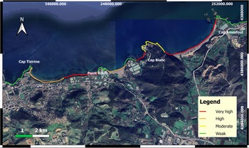
Coastal vulnerability index (IVCphy) for the littoral of Cherchell, after the model of Amrani and Fernane Reference Amrani, Fernane and Belkessa2021 (image: B. Donia; base map: © 2021 Maxar).

The port will extend along the coast from east to west between Amesfout Cape and Riadh Cape. Its construction will require the infilling of the supratidal zone and part of the infralittoral, including the beach of El Hamdania, the cove of Rocher Blanc Cape and the beach of Oued El Bellaa, for the construction of the south quay. In its north–south extent, the port infrastructure will occupy the space between the shoreline up to the approaches to the N11 National Highway at the City Ben Kheira, approximately 2.5 km inland. The construction will also include the mountain dominating the Rocher Blanc Cape, the bed of Oued El Hachem and the mountain dominating the beach of Hamdania.
Impacts of the establishment of the port of El Hamdania on the coast and the archaeological heritage
The Mediterranean basin and particularly the North African zone are among the regions most vulnerable to climate change (Chourghal et al. Reference Chourghal, Lhomme, Huard and Aidaoui2016). The latest studies show that the southern coastal regions of the Mediterranean are very affected by the impact of global warming and are exposed to the risk of flooding due to the dry climate (Ali et al. Reference Ali, Cramer, Carnicer, Georgopoulou, Hilmi, Le Cozannet, Lionello, Pörtner, Roberts, Tignor, Poloczanska, Mintenbeck, Alegría, Craig, Langsdorf, Löschke, Möller, Okem and Rama2022).
A recent study was conducted to assess the coastal vulnerability of the central western Algerian coast to erosion and marine flooding, focusing on the Cherchell shoreline (Amrani et al. Reference Amrani, Fernane, Naili, Ryhane and Belkessa2021). It was based on the evaluation of the physical vulnerability index according to the Gornitz approach (Gornitz et al. Reference Gornitz, Daniels, White and Birdwell1994) enriched by Hammar-Klose and Thieler in 2001 (Pendelton et al. Reference Pendelton, Hammar-Klose, Thieler and Williams2004), as well as on the evaluation of the socio-economic vulnerability index, adopting the approach of McLaughlin and Cooper (Reference McLaughlin and Cooper2010).
The results show that the east coast of Cherchell is faced with the risks of erosion and marine submersion (Figure 7), indicating a high and very high vulnerability level along the sandy stretches of coastline, and a low to moderate vulnerability level along cliffs and rocky coasts. (Amrani et al. Reference Amrani, Fernane, Naili, Ryhane and Belkessa2021, 80). The results also demonstrate a very high socio-economic vulnerability level in areas with economic activity, and a very low level in those areas free from the anthropic factor.
In 2016 the Maritime Studies Laboratory LEM produced a report on the impacts of the development of the port of El Hamdania on the human environment (LEM 2016). Two specific phases examined the sources of possible impacts on the archaeology with the aim to reduce damage to sites: (1) the port construction phase, and (2) the port operation phase. The aim of this report was to reduce negative impact on archaeological sites.
The establishment of the port of El Hamdania will have a significant impact on our study area, changing its physical and biological parameters. Notably, the port infrastructure will play a significant role in the modification of the currents, influencing the movements of sediments, particularly in the region where the El Hacheme and El Bellaa wadis are the main sources of continental sediments (LEM 2016, 117). For swells coming from the eastern sector, a coastal current parallel to the coast will be observed to the east of the port, flowing from east to west. To the west of the port the coastal current will maintain an east–west direction; however, an expansion current in the opposite direction to the coastal current will be created in the shadow zone, very close to the rooting of the main jetty. By symmetry, we find the same type of currentology for the swells coming from the western sector. These disturbances of coastal hydrodynamics will have the effect of completely disrupting coastal transit. According to the study LEM carried out (LEM 2016), the coastal transit of sediments heading from west to east is greater than that heading from east to west. Given that the planned port development will obstruct coastal transit, hydro-sedimentary upheavals will be generated. A continuous depositing of sediments will be observed at the level of the rooting of the secondary and main piers. In addition, there will be a gradual erosion of the coast to the east of the port due to a lack of coastal transit. This erosion could be aggravated by the fact that the sediments transported by the Hachen wadi will no longer be able to reach the eastern zone of the port, since they will be blocked by the main jetty. This erosion will directly affect Amesfout Cape and will be of great danger to the site of the Trois Ilots. In addition, the establishment of the port will have the immediate effect of destroying the fauna and flora of the area (Mauvais Reference Mauvais1991, 25). This could be problematic as Posidonia meadows are present in this area, which form an important part of the subaquatic ecosystem (Imene Reference Imene2019). Furthermore, the port development will require a reorganisation of the natural landscape, including Rocher Blanc Cape and its woods, and the forest overlooking Amesfout Cape, but also the creation of road and railroads, which will move through farmland.
Discussion
It is indisputable that, socio-economically, the creation of the commercial port of El Hamdania will offer economic opportunities to the people of the region of Cherchell and to people in Algeria in general, thus creating jobs for individuals who will see their agricultural lands confiscated, but also the revitalisation of local commercial enterprises. However, agricultural activity will fade away in favour of industrial activity (LEM 2016, 187). Ecologically, changes in physical and biological parameters will be inevitable during both the construction phases and the operational phases. The establishment of the industrial zone will affect the different environments of the region in the short and the long term, both with the risks involved during the construction phase of the port and its operational phase. These impacts have been assessed as very negative. These include atmospheric and volatile pollutants, the disruption of communication channels, pollutants caused by engine emissions and ship fuels during port operation, as well as sound and light pollutants (artificial lighting) generated by the building and day-to-day operation of the port. All these factors will affect the functioning of the ecosystem, but also the health condition of individuals, without the implementation of a plan to mitigate them (LEM, 2016, 187).
Morphodynamically it is difficult to determine the changes that will take place on the coastal landscape with precision. However, we will strive to put forward hypotheses and forecasts about the impact of this port installation on the coast. The port of El Hamdania is a deep-water structure, which will cause a change in the dynamics of sediment transit. The swell plays a major role in sediment transit with a capacity of 43 000 m3 from west to east (LEM 2016, 128). Applying the sedimentological model established by Manoujian (Reference Manoujian1984), we will be able to predict the influence of marine structures on the natural environment. Deep-water structures (−12 m to −15 m) cause arrow-shaped sedimentation in the direct vicinity of breakwaters over time, as well as significant erosion in windward areas, as exemplified, for instance, at the harbour of Ashod (Manoujian, Reference Manoujian1984).
In our study area, the wide Tizirine beach will experience erosion in its eastern part, far from the protection of the Cape. That said, the impact will compensate for the loss of sediments and may provide stabilisation or progradation for this area. Amesfout Cape, however, will no longer be protected by sedimentary inputs from marine fauna and flora and from the El Hachem and El Belaa rivers, which will be diverted from their courses. This area, extending up to 6.5 km east will, therefore, suffer from erosion (Aleman et al. Reference Aleman, Raynal, Certain, Robin and Brunel2017, 30). Over time, the dynamics of the coast will tend towards a balance by restoring part of the sedimentary transit longitudinally to the coast, and thus supplying the sites in deficit downstream (Aleman et al. Reference Aleman, Raynal, Certain, Robin and Brunel2017, 29).
Archaeologically, the construction of the port of Hamdania will directly and indirectly affect the cultural heritage present in the study area (Figure 8). The remains of the villa of Rocher Blanc Cape will be destroyed during the levelling process of the construction site. The submerged cannons discovered in the small creek will have to be moved. Because of this, their archaeological context will disappear, and their life expectancy remarkably reduced, if there is no suitable treatment. However, the prospect of creating a visitable submerged site will be most attractive for tourism and the local economy. Further west, the fishponds sheltered by Tizirine Cape will be at risk of clogging up with parts of the sediment transit, which will be slowed down by the breakwaters of the port. As for the site of Trois Ilots, both the promontory and the remains will undergo erosion because of changing coastal morphodynamics that will be created by the protective infrastructures of the port. Moreover, the necropolis located on the low side of road N109 will be affected by the work of the port with the construction of the enclosures, and perhaps they will even disappear.
Coastal repartition of the archaeological sites and the locations of the El Hamdania port project (image: B. Donia; base map: © 2021 Maxar).

Conclusion
The geographical and geomorphological richness of the east coast of Cherchell has long captivated mankind, who have found shelter there since prehistoric times. The diversity of the landscapes led to the development of a number of agricultural and fish farms during antiquity at the height of Mauritania's capital. These agricultural and maritime activities can still be found in the area today.
The establishment of the port of El Hamdania will change the urban and coastal landscape. However, in addition to creating jobs, it will open up possibilities to increase archaeological studies in the region, establish procedures for the protection of the coast and develop a methodology for the prevention and conservation of cultural property.