Introduction: Cruz de la Boca on the Northern Frontier
Scholarship on northwestern Mesoamerica has long recognized a series of hilltop centers that developed along the northern frontier during the Late Classic–Epiclassic eras (a.d. 600–900). La Quemada and Alta Vista provide the principal comparative baselines, although many other centers remain only partially published or insufficiently documented (Aveni, Hartung, and Kelley Reference Aveni, Hartung and Kelley1982; Foster and Gorenstein Reference Foster and Gorenstein2000; Nelson Reference Nelson1997; Torvinen and Nelson Reference Torvinen and Nelson2020). Cruz de la Boca (CDB) belongs to this broader constellation: a double hilltop complex overlooking corridor routes that linked the Mesa Central with the Súchil and San Antonio drainages. In a region where only a small number of such centers have been mapped in detail, the full publication of CDB’s architecture and settlement pattern offers a rare opportunity to refine comparative models of frontier urbanism, social inequality, and interregional interaction. Accordingly, this article has three aims: first, to present a transparent, georeferenced map of the site’s nuclear zone and flanking hills; second, to articulate a working model of site organization appropriate to the Súchil branch (Jiménez Reference Jiménez2020; Kelley Reference Kelley, Foster and Gorenstein1985); and third, to examine the social stratigraphy of the hilltop by exploring how hut-like Loma San Gabriel (LSG) foundations on outer benches relate spatially and socially to the heavier Chalchihuites-style compounds and sunken courts in the core. This last point is especially important because LSG is treated here not simply as a typological label, but as part of a long-standing archaeological problem concerning the place of local farming-foraging traditions on the northern frontier and their relationship to Chalchihuites expansion (Foster 1978, 1986a, 2022; Kelley Reference Kelley, Cabrero, King and Jiménez2002; Spence 1971). By approaching that problem through new spatial documentation, the article brings both the archaeology of the northern frontier and the interpretive status of Loma San Gabriel back into sharper focus for current scholarship.
CDB sits on the northwestern side of the Mesa Central, near the transition to the Sierra Madre Occidental. The landscape alternates high sierras (often capped by small mesas) with intermontane valleys whose floors carry erosional terraces and low rolling knolls (lomeríos), trending roughly north–south to northwest–southeast across western Zacatecas and into Durango (Brown Reference Brown1984; Foster and Gorenstein Reference Foster and Gorenstein2000) (Figure 1). Within this mosaic, CDB occupies twin rhyolitic heights—Cerro de la Cruz and Cerro de los Bueyes—overlooking the easiest approach from the San Antonio River Valley. The massif lies at ∼23°35′30″ N, 103°36′40″ W, ∼2300 masl, and belongs to the Súchil branch together with sites such as Alta Vista and Cerro Moctehuma. Tertiary acidic volcanic rocks—thick tuffs and rhyolites—create competent benches and ledges exploited for platforms and stair segments keyed directly to bedrock, while dacite flows in local catchments provided dense ground stone. A summer rain/long dry season regime enhances visibility on slopes during parts of the year but accelerates sheetwash and erosion, concentrating stable architecture on benches and saddles. CDB and its Súchil-branch peers occupy valleys tied to the San Antonio and Colorado systems, separated only by a low mountain chain—an arrangement that creates natural east–west and north–south movement corridors along valley floors and saddles and helps explain the site’s position above the main access from the San Antonio drainage.
Location of Cruz de la Boca within the northcentral Mexican highlands in relation to modern state boundaries and the conventional northern border of Mesoamerica.

Figure 1 Long description
A map depicting the location of Cruz de la Boca within the northcentral Mexican highlands. The map includes modern state boundaries and the conventional northern border of Mesoamerica. Key locations such as La Ferreria, Alta Vista, La Quemada, Santiago and El Coporo are marked. An inset map shows the broader region of Mexico for context. The map features topographical details and a compass rose in the top right corner.
The broader environmental frame is the semi-arid Central Mexican Plateau, a highland corridor between the Sierra Madre Occidental and Sierra Madre Oriental. A low east–west range in Zacatecas divides it into the Northern Plateau (Mesa del Norte), dominated by internal basins, the Chihuahuan Desert, and the Bolsón de Mapimí, and the higher Southern Plateau (Mesa del Sur), where relict lake basins and river valleys supported more intensive agriculture. This mosaic of basins, ridges, and former lakes produced neither a simple boundary between Mesoamerica and Arid America nor a culturally uniform zone, but a patchwork of niches in which hunting-gathering, mixed economies, and sedentary farming lifeways coexisted and interacted. Earlier scholarship captured this condition through the metaphor of the “Chichimec Sea” (Kelley Reference Kelley1974; Mathien and McGuire Reference Mathien and McGuire1986; Riley and Hedrick Reference Riley and Hedrick1978), envisioning the northern frontier as a fluid interaction field rather than a fixed civilizational divide. In the formulation most relevant here, Kelley’s “Mexican cultural littoral of the Chichimec Sea” described a frontier world in which farming villages, Chalchihuites centers, and more mobile groups were connected through exchange, labor, conflict, and selective borrowing, even as they differed in settlement scale, subsistence strategy, and institutional affiliation. The later reuse of the metaphor in titles such as Across the Chichimec Sea and Ripples in the Chichimec Sea underscores its enduring interpretive force in scholarship on Mesoamerican–northern interaction.
In this belt, sedentary agricultural enclaves, Chalchihuites centers, and Epiclassic ceremonial sites coexisted with highly mobile forager groups whose seasonal movements followed desert-swamp-mountain resource cycles documented for the Bolsón de Mapimí and the lagoon region of Coahuila-Durango. The result was a braided zone of encounter in which “Chichimec” and “Mesoamerican” lifeways overlapped in space, with competition, alliance, and mutual borrowing structured by water, arable pockets, minerals, and corridor routes—the same constraints that shape CDB’s position above the Súchil-San Antonio drainages.
Within this braided frontier, the Loma San Gabriel culture represents one of the earliest documented farming-foraging traditions along the northwestern margin of Mesoamerica. Before the rise of the Chalchihuites culture, small LSG hamlets and villages occupied elevated benches and low hilltops in Zacatecas and Durango, typically overlooking arable pockets and water sources (Foster 1978, 1986a, 2022; Kelley Reference Kelley, Cabrero, King and Jiménez2002). Lithic continuities link LSG to local Archaic (Los Caracoles) adaptations, suggesting a gradual transition from mobile foragers to more sedentary mixed-economy households between ca. 200 b.c. and a.d. 200 rather than abrupt colonization from central Mexico (Spence 1971; Kelley 1952). The earliest securely dated LSG ceramics come from a Canutillo-phase context at Gualterio Abajo (a.d. 100–400), making at least part of the LSG sequence broadly contemporaneous with early Chalchihuites occupations in the Súchil-Chalchihuites region (Kelley 1976). Chronological control remains coarse because many LSG sites lack diagnostic artifacts; current models rely on cross-dating with Chalchihuites wares, projectile point typologies, and limited obsidian hydration dates, underscoring the need for tighter sequencing and explicit comparison with Chalchihuites phases (Darling 1998).
LSG settlement patterning is modest but consistent: dispersed clusters of rectangular dwellings built with cobble-and-slab foundations supporting wattle-and-daub superstructures, sometimes in single room and sometimes in multiroom configurations (Foster 1986a). At sites such as La Manga, an open space between structures suggests incipient patio-like organization, but many LSG sites lack the formalized patio compounds characteristic of later Chalchihuites centers (Foster 2022). Small circular structures (2–3 m in diameter) occur independently or attached to rectangular units and likely served as flexible spaces for habitation, storage, and small-scale ritual (Foster 1978). This light architectural grammar—low investment, perishable superstructures keyed to local stone—provides the baseline for interpreting LSG-type hut-like foundations on outer benches at CDB.
The material culture associated with the LSG tradition is likewise described as simple. Ceramics are dominated by Loma Plain, a coarse- to medium-tempered ware ranging from light buff to dark brown, often with unpolished surfaces and very little decoration (Foster 1986a, 2022). Vessel repertoires emphasize ollas with flared rims tailored to cooking and storage rather than conspicuous display (Foster 2022). Occasional Chalchihuites vessel elements and forms appear in LSG assemblages, signaling interaction and selective borrowing without full assimilation into Chalchihuites ceramic vocabularies. Chipped-stone assemblages show a stylistic continuum from Archaic Los Caracoles industries into the LSG horizon, reinforcing arguments for local developmental trajectories rather than wholesale replacement (Spence 1971). Subsistence evidence points to a broad-based mixed economy in which basic agriculture was consistently supplemented by wild plant and animal resources—a strategy well suited to semi-arid, risk-prone environments (Brooks et al. 1962; Foster 1978; Morrow and Reinhard 2016).
Crucially for CDB, LSG groups did not disappear with the arrival of Chalchihuites; instead, they entered into symbiotic but unequal relationships with Chalchihuites centers. During the Canutillo phase (ca. a.d. 100–650), when Chalchihuites communities consolidated in the Río Súchil–Chalchihuites region, LSG populations appear to have supplied labor for mining and related activities in western Zacatecas, with this relationship intensifying as Chalchihuites expanded north into Durango after a.d. 700 (Kelley 1971, 1985; Weigand 1968, 1978, 1982). Despite strong Chalchihuites influence at some LSG sites, the LSG tradition maintained a distinct material and settlement identity and is widely considered ancestral to historically documented Tepehuan and Zacateco groups following the decline of Chalchihuites around a.d. 1350 (Riley and Winters 1963; Weigand 1978). CDB thus offers a vantage point for examining how such LSG households might have been incorporated—spatially and socially—into an Epiclassic hilltop center anchored in Chalchihuites tradition.
A central issue in the archaeology of the northern frontier is therefore not simply whether Loma San Gabriel existed, but how it should be interpreted within broader frontier dynamics. In what may be called Loma San Gabriel senso Kelley and Foster, LSG is understood as a distinct local farming-foraging tradition rooted in northwestern Zacatecas and Durango, with relatively light domestic architecture, simpler material repertoires, and a developmental history that preceded and overlapped with the Chalchihuites tradition rather than merely deriving from it (Foster Reference Foster1980; Kelley Reference Kelley, Cabrero, King and Jiménez2002). In this view, LSG households formed part of the long-term local substrate of the northern frontier and entered into asymmetrical but enduring relations with Chalchihuites centers as those centers expanded and consolidated. This is also the reading behind models in which local populations preserved a degree of identity while selectively adopting Mesoamerican traits and participating in a wider frontier interaction field (Foster Reference Foster1980; Kelley Reference Kelley, Cabrero, King and Jiménez2002).
By contrast, Loma San Gabriel senso Hers expresses skepticism toward treating all small, simple, or lightly built settlements as evidence of a separate cultural entity. Writing from the Durango evidence, Hers argued that the supposed distinction often rested on older assumptions of northern “simplification” or “primitivism,” and that sites in the heart of the so-called Loma San Gabriel territory could instead call into question the very existence of LSG as an entity distinct from Chalchihuites (Hers Reference Hers1989). In that reading, some of the archaeological pattern attributed to Loma San Gabriel may reflect differences in settlement hierarchy, architectural investment, and social position within broader Chalchihuites formations, especially between major centers and more modest rural occupations, rather than a wholly separate culture (Hers Reference Hers1989).
Later Durango scholarship has made the problem sharper rather than simpler. Historiographic syntheses emphasize that the real point of disagreement is often the degree of differentiation between Chalchihuites and LSG-like occupations: whether these reflect a distinct local tradition later chalchihuitized, a more peripheral and lower-investment rural stratum within a hierarchized Chalchihuites world, or some historically variable combination of both (Liffman Reference Liffman2010; Punzo Reference Punzo Díaz2016). In this sense, the question is not only whether Loma San Gabriel “existed,” but how different populations, architectural traditions, and social positions were articulated across the frontier.
In this context, we use Cruz de la Boca to test a set of working expectations about how different groups shared and negotiated the hilltop. First, we ask whether hut-like LSG-type foundations form peripheral belts around denser Chalchihuites-style compounds and sunken courts, consistent with a model of peripheral co-residence rather than homogeneous scatter. Second, we examine whether paths from LSG clusters and core domestic ranges converge on the same central courts along comparable, walkable routes, implying shared public arenas. Third, we compare architectural investment and associated ceramics and tools to evaluate whether LSG households represent a lighter-built, materially distinct stratum within walking distance of the courts. Finally, we consider whether household ritual practices in core units bordering courts—and, in future work, LSG structures—point toward shared ritual horizons or more separate ritual worlds. Together, these expectations allow us to distinguish between classic stratified hierarchies, more heterarchical or segmentary configurations, and multicommunity frontier enclaves, reframing Loma San Gabriel not as a purely typological label but as a component of a social stratigraphy that can be explicitly tested in space.
Following a long comparative tradition anchored in shared material repertoires across Mesoamerica, we treat long-distance interaction as layered networks—bulk staples, political–military ties, prestige-goods circuits, and information networks (Foster and Gorenstein Reference Foster and Gorenstein2000; Englehardt and Carrasco Reference Englehardt and Carrasco2019; Jiménez Reference Jiménez2020). In pre-capitalist settings, prestige networks often carry disproportionate transformative force because they legitimate local elites and underwrite competitive emulation; these networks pulse through time with phases of contraction and expansion, a pattern visible on the northern frontier (Blanton and Feinman Reference Blanton and Feinman1984; Hall, Kardulias, and Chase-Dunn Reference Hall, Kardulias and Chase-Dunn2011; Jiménez Reference Jiménez2020). CDB’s inhabitants likely participated in such networks indirectly—through labor contributions, localized exchange, and selective adoption of prestige forms—while Chalchihuites centers leveraged more visible monumental and ceramic media.
CDB’s architectural grammar and surface materials align it with the Epiclassic pulse, when Súchil-branch centers organized ritual and residential space on prominent hills (Aveni, Hartung, and Kelley Reference Aveni, Hartung and Kelley1982; Jiménez Betts and Darling Reference Betts, Peter, Darling, Foster and Gorenstein2000). During this period, intensified agricultural investment, population aggregation, and the circulation of prestige goods coincided with the spread of distinctive architectural ensembles—especially sunken patio-pyramid compounds—that materialized emerging forms of hierarchy and competition. Debate over the nature of the northern frontier has long oscillated among “periphery” models, which cast the region as a dependent margin of central Mexican cores; local process approaches, which emphasize autochthonous developments; and synthetic perspectives, which foreground migration, exchange, and emulation. CDB is best understood within this latter frame: its local provisioning and construction logics were fundamental, yet its affiliation with the broader Chalchihuites tradition—particularly the Súchil branch—is evident in its decorated ceramics, sunken patio compounds, and hill-centered circulation design (Golitko and Feinman Reference Golitko and Feinman2015; Jiménez Reference Jiménez2020; Murakami Reference Murakami, Tsukamoto and Inomata2014; Strazicich Reference Strazicich1998; Tsukamoto and Inomata Reference Tsukamoto and Inomata2014). Across this regional tradition, Epiclassic centers on the northwestern periphery shared a recognizable repertoire that included sunken patios, often with double perimeters and occasional central altars, together with decorated wares such as red-on-cream/orange, black-on-red, and sgraffito types. Within that broader pattern, Súchil-branch sites along the Súchil-San Antonio-Colorado drainages frequently anchored platforms to rhyolitic bedrock benches and concentrated civic architecture in saddles between prominent knolls, providing the closest comparative baseline for CDB. Rather than make strong claims in advance about political scale, we use these shared traits as the basis for an operational model with measurable expectations for layout, access, material distributions, and social stratigraphy (Renfrew Reference Renfrew, Renfrew and Cherry1986; Renfrew and Cherry Reference Renfrew and Cherry1986).
Regional chronological anchors and alignment studies at La Quemada and Alta Vista (e.g., Aveni et al. 1978, Reference Aveni, Hartung and Kelley1982; Lelgemann 1992, 1997, 2000; Nelson 1986, Reference Nelson1997, 2001) situate these centers within an Epiclassic (ca. a.d. 600–900) wave of population growth, agricultural intensification, and architectural standardization on the northern frontier. At Alta Vista, cardinally oriented sunken plazas, columned halls, and horizon-based solar alignments tied to the Tropic of Cancer articulate a cosmologically charged patio-compound grammar. La Quemada, in the Malpaso Valley, mirrors this emphasis on patio compounds—raised platforms around sunken courts with central altars and flanking pyramids—while following its own trajectory of growth and abandonment (García Pimentel et al. Reference García Pimentel, Torreblanca, Solano, Cejudo, García, Goguitchaichvili, Belmontes and Morales2021; Lelgemann 1997, 2000; Trombold 1985, 1990). Beyond La Quemada and Alta Vista, recent work at El Teúl and Las Ventanas expands the comparative sample of northern hilltop centers, reinforcing the pattern of patio compounds bracketing larger civic courts (Mozillo Reference Mozillo1990; Nelson et al. Reference Nelson, Canchola, Luis Punzo Díaz and Minnis2015; Torvinen and Nelson Reference Torvinen and Nelson2020; Wells Reference Wells2000). CDB’s central saddle and dual ascents echo this grammar of aggregation below and restriction above, tuned to the local benchland.
Within this frame, we treat Cruz de la Boca as a local social field in Bourdieu’s sense, where differently positioned groups (LSG and core Chalchihuites-style residents) bring distinct material resources and practices into play. Following sections use the site’s architecture, circulation, and surface assemblages to model this social stratigraphy through four expectations about peripheral co-residence, shared public spaces, differential domestic investment, and overlapping or separate ritual horizons.
A second strand of northern frontier research concerns mining, lithic provisioning, and prestige goods exchange, especially in relation to the Chalchihuites tradition. During the Canutillo phase, villages in the Río Súchil-Chalchihuites area became deeply involved in turquoise mining and working, alongside the extraction of hematite, flint, rhyolite, and quartz (Kelley Reference Kelley, Foster and Gorenstein1985; Weigand 1968, 1978, 1982). Turquoise ornaments, mosaic inlays, and ritual objects from Alta Vista and related sites attest to the ceremonial and political weight of blue-green stones, while Chalchihuites communities relied heavily on local formations—dacites, rhyolites, sandstones—for bulk construction and everyday tools. Long-distance circuits moved high-value materials (turquoise, obsidian, copper) across the northwest frontier, linking Chalchihuites centers with the Pacific coast, central Mexican cores, and the US Southwest (Córdova and Martínez 2021; Hosler 1994; Melgar Tísoc 2010; Schiavitti 1996; Weigand 1977, 1982). This dual regime—local provisioning for bulk construction and supra-regional circuits for prestige materials—provides the economic backdrop for CDB’s architecture and assemblages.
Ceramic typological and archaeometric research across the northern frontier likewise provides essential comparative context. Studies on Chalchihuites and related traditions—from the Río Súchil and Guadiana Valleys to the Malpaso and San Luis basins—document a spectrum from coarse local cooking wares to highly finished incised, negative-painted, and polychrome serving vessels linked to Epiclassic elites (Córdova 2006; Kelley and Bell Reference Kelley1974; Martínez 2007; Nelson and Martin Reference Nelson, Canchola, Luis Punzo Díaz and Minnis2015; Pomedio et al. 2013; Punzo Reference Punzo Díaz2016; Sandoval 2011; Strazicich Reference Strazicich1998; Turkon et al. 2018; Vidal Aldana 2017). Paste recipes, temper, and elemental signatures reveal multiple local and microregional production zones embedded in wider stylistic and exchange circuits (Turkon 2020). Our preliminary ware definitions and counts at CDB align with this northern frontier ceramic literature: coarse, medium-tempered cooking wares appear to be predominantly local or near-local products, while a subset of finer wares resonates with Epiclassic innovations associated with the La Quemada-Alta Vista sphere. Detailed petrographic and elemental analyses remain future work, but macroscopic fabric observations already suggest that CDB is neither an isolated provincial outlier nor a simple copy of better-known centers.
Survey design and methods
We combined archival and cartographic review, remote sensing and GIS, systematic pedestrian coverage, total station/GPS mapping, controlled surface collections, and a targeted rescue excavation.
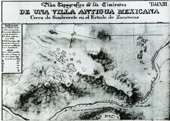
CDB entered the record via that early topographic plan by Carl de Berghes (Figure 2), The archival component foregrounded Carl de Berghes’s 1833 plan—valuable as a record of stairways, and a pyramidal structure no longer fully preserved. We used this map as a historical locator, not as a metrically reliable base, and superseded it with modern geodetic control derived from the protection polygon and leveling traverses on both hills.
Carl de Berghes’s 1833 topographic plan of the “ancient Mexican town” near Sombrerete, Zacatecas, showing the hilltop architectural core and surrounding sectors of Cruz de la Boca.

Figure 2 Long description
The image shows a topographic plan titled 'Plan Topografico de los Cimientos de una Villa Antigua Mexicana Cerca de Sombrerete en el Estado de Zacatecas.' It is labeled as Table XIII. The map illustrates the architectural core on a hilltop and surrounding sectors, including Cruz de la Boca. Various structures and pathways are depicted, with annotations in Spanish. The layout includes a river on the right side and detailed terrain features. A legend on the left provides additional information about the map's elements.
Feature recording targeted stairways, platforms/terraces, sunken patio compounds, rooms, and diagnostic wall lines; we additionally flagged small, single-course, often incompletely closed foundations as a distinct “LSG-type” category, recognizing their provisional association with LSG tradition and their potential importance for reconstructing social stratigraphy. For each feature class, we documented plan, dimensions, construction (stone type, coursing, use of bedrock or mortar), preservation, slope/setting, and associated surface materials. Total station traverses with a Nikon instrument captured stair flights, patio rims, scarp breaks, and platform edges, accelerating fieldwork while preserving coordinate integrity in WGS 84/UTM 13N. In the central saddle (“La boquilla”)—the densest architectural zone—we mapped platforms, altars, stairways, terraces, patios, and rooms despite erosional channels, brush, and livestock impacts that complicate visibility.
Our survey was designed to establish a baseline for Cruz de la Boca by delimiting a legally defensible protection perimeter, setting geodetic control and a sector scheme aligned with terrain, documenting architecture with consistent attributes, linking surface collections and condition data to spatial context, and differentiating between massive patio-banquette compounds and lighter hut-like foundations (LSG tradition) to explore social stratigraphy across core and peripheral residential zones.
The first field season fixed a protective polygon of 234.56 ha and formalized a sector scheme (NW/NO, SW/SO, Central, SE, W1, W2, with NE reserved for future work), giving each sector stable names and boundaries for subsequent mapping and analysis (Figure 3).
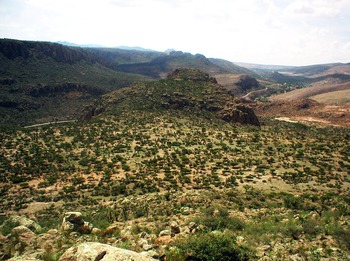
View across the nuclear zone of Cruz de la Boca, looking toward Cerro de la Cruz in the background and showing “La Boquilla” narrow ridge.

Figure 3 Long description
The image shows a landscape view of a hilly terrain with sparse vegetation. The foreground features rocky ground with scattered bushes and small plants. In the middle ground, a prominent hill rises, covered with similar vegetation. The background displays a range of hills and mountains extending into the distance, under a partly cloudy sky.
Within this frame, we set primary tie points, a benchmark, and auxiliary “bancos de nivel” from which leveling runs traced contours from the central mesa to the summits of Cerro de los Bueyes and Cerro de la Cruz, providing the control grid for sector plans (Figure 4). Vegetation, erosion, livestock traffic, and looting often obscured edges and corners, so the team cleared brush locally, flagged corners and faint alignments, and backfilled or capped many looters’ pits with nopales and soil, recording their locations as part of a condition log used to qualify visibility bias in feature counts. By the end of the 2003 season, roughly 55 percent of the structures inside the polygon had been topographed. Most of the remaining features lie in the NE sector, additional complexes in the SE (including the ballcourt), and scattered structures at the polygon’s margins. Further architecture on adjacent hills—many Loma San Gabriel-type features and hunter-gatherer occupations—was deliberately left outside the legal frame, as including them would have required a protection zone exceeding 450 hectares and even incorporating portions of the state highway.
Protection polygon and survey sectors at Cruz de la Boca, showing the proposed protection polygon (red) and the distribution of total station-recorded features within the Central, NW, NE, SW, SE, W1, W2, and Loma San Gabriel sectors.

Figure 4 Long description
A topographic map displaying the protection polygon at Cruz de la Boca, outlined in red. The map includes labeled sectors: Central, NW Sector, NE Sector, SW Sector, SE Sector, W1 Sector and W2 Sector. The Loma San Gabriel area is also marked. Contour lines indicate elevation changes. A legend indicates the count of GPS points, with symbols for control sites and protection polygons. A scale bar and north arrow are present for orientation.
Our data management prioritized reproducibility across the different components of the 2003 field campaign. Control points, raw total station files, photograph logs, and feature registers were recorded in UTM 13N and maintained with consistent metadata, while GIS compilation and symbology were standardized to permit sector-by-sector comparison and future integration of mapping, conservation, collection, and excavation datasets, as reflected in the site’s 2003 technical reports (Nicolás Caretta Reference Nicolás Caretta2003a, Reference Nicolás Caretta2003b, Reference Nicolás Caretta2003c, Reference Nicolás Caretta2003d, Reference Nicolás Caretta2003e). Surface collections began only after the protection polygon and sectorization had been defined. Diagnostic ceramics, lithics, and occasional ornaments were bagged with sector and locus metadata, although ongoing looting also necessitated opportunistic recovery around fresh cuts, which were backfilled or capped whenever possible to mitigate further disturbance. Ceramic materials were processed at the INAH Zacatecas archaeology laboratory through washing, sorting, typological classification, and recording of surface treatment, with selected samples retained for future petrographic study; lithics and ground stone were likewise classified, attributed by raw material and tool form, and keyed through catalog records to the GIS spatial framework. In addition, a fresh looters’ pit in a domestic room adjacent to a sunken patio was subjected to controlled intervention: the cut was cleaned, 2 × 2 m units were laid out, profiles were recorded, and burials and stratigraphy were documented through plans, profiles, and photographic control tied to the same coordinate system used for mapping. This intervention produced a first stratified sample of core-area domestic and ritual practice (Nicolás Caretta Reference Nicolás Caretta2003a, Reference Nicolás Caretta2003c, Reference Nicolás Caretta2003d, Reference Nicolás Caretta2003e).
Within the broader literature on the Chalchihuites tradition, the Loma San Gabriel horizon, and Súchil-branch hilltop centers, the georeferenced plan and social-stratigraphy framework developed here provide the foundation for the operational model of CDB’s organization that we develop in the sections that follow.
Theory and method for social stratigraphy and Loma San Gabriel integration
Rather than treating hierarchy at Cruz de la Boca (CDB) as a simple function of monument size, we approach it as a problem of social stratigraphy: how different kinds of residential architecture, circulation, and material practice stack and interleave around shared public spaces. We focus on the relationship between hut-like foundations we provisionally classify as Loma San Gabriel (LSG) tradition and the more massive patio-banquette compounds and sunken courts in the nuclear zone.
For clarity, we distinguish between LSG as a regional tradition and LSG-type foundations as an architectural category at CDB. By “LSG tradition” we mean the cultural-historical complex documented in Zacatecas and Durango—characterized by mixed farming–foraging subsistence, Loma Plain ceramics, and light cobble-and-slab dwellings (Foster 1978, 1986a, 2022; Kelley Reference Kelley, Cabrero, King and Jiménez2002). By “LSG-type foundations” at CDB we refer specifically to small, hut-like bases that meet the following criteria: (1) single-course wall lines, often incomplete or only loosely enclosed, (2) small footprints (typically on the order of 3–5 m per side), (3) absence of double walls, internal patios, or clear integration into formal patio-banquette compounds, and (4) location on outer benches or boquilla margins rather than within the densest compound fields. These features are provisionally interpreted as local architectural expressions of the LSG tradition, but our classification is explicitly functional for the social-stratigraphy analysis that follows.
This distinction is deliberately heuristic rather than culture-historically final. In the Durango literature, modest cobble-and-slab architecture of the kind grouped here as LSG-type has been interpreted in two different ways: on the one hand, as material evidence of a distinct local tradition with long developmental depth (Foster Reference Foster1980; Kelley Reference Kelley, Cabrero, King and Jiménez2002); on the other, as the archaeological expression of lower-investment, lower-rank, or more rural sectors within the broader Chalchihuites sphere (Hers Reference Hers1989). As later historiographic review makes clear, the issue is less a simple opposition between “presence” and “absence” than a question of the degree of differentiation and hierarchical coexistence among interrelated frontier groups (Liffman Reference Liffman2010). We therefore use “LSG-type” at CDB as an architectural and spatial category suitable for comparative analysis, while leaving open the larger interpretive question of whether these remains index a separate co-resident tradition, a subordinate stratum within a Chalchihuites-centered settlement, or a historically contingent mixture of both.
Our central working hypothesis is that LSG groups and Chalchihuites-style residents were co-existing participants in CDB’s public spaces, while inhabiting distinct peripheries on outer benches and margins. This implies a social field where different lifeways and statuses intersected in the same courts but were differentiated in where and how they lived. We frame this using Bourdieu’s concepts of field, habitus, and capital, in which social positions are defined relationally within structured “fields of practice” and “fields of cultural production,” rather than as simple rank ladders (Bourdieu Reference Bourdieu1977, Reference Bourdieu1984, Reference Bourdieu1993). In this view, the hilltop is a local field where different groups bring distinct combinations of economic, social, and symbolic capital into play, and where built space helps reproduce or renegotiate those relations of power and distinction.
Archaeologically, we align this with practice- and agency-oriented work that uses Bourdieu to link material patterning to embodied dispositions and field positions (Dobres and Robb Reference Dobres and Robb2000; Dornan Reference Dornan2002; Edgeworth Reference Edgeworth2010; Joyce Reference Joyce2005; Knapp Reference Knapp2008). Rather than contrasting “core” vs. “periphery” in purely political terms, we treat spatial and architectural patterning at CDB as the cumulative outcome of positioned practices—what different groups could do, where, and with which resources—within a shared but uneven field.
To make this question testable, we define four expectations (S1–S4) that operationalize social stratigraphy with the data available here: total station/GPS mapping, architectural classification, circulation mapping, surface collections, and the emergency excavation. Framed this way, they also provide a way to engage the broader Loma question in northern frontier archaeology. If LSG-type features at CDB represent a distinct co-resident tradition in the sense proposed by Kelley and later Durango scholarship, we would expect patterned peripheral clustering, lighter domestic investment, and shared but asymmetrical access to central courts. If, instead, such features mainly reflect internal social differentiation of the sort emphasized by Hers, then the same spatial contrasts might be read less as evidence of separate populations and more as differences in rank, labor, and domestic investment within a shared social formation. Our aim is not to resolve that debate definitively with one site, but to show how a detailed map and explicit spatial expectations can move it from typological assertion toward testable archaeological patterning.
Each expectation targets the relationship between LSG features and the functioning of the site, while also helping determine whether that relationship is better understood as one of co-resident traditions, internal differentiation, or frontier hybridity.
S1: Peripheral co-residence. If LSG groups co-existed with core residents but occupied the peripheries, we expect LSG-type foundations to form belts or clusters around, rather than within, the densest patio-compound fields of the boquilla and major benches. In practice, this can be evaluated by comparing the spatial distribution of LSG hut-like foundations to formal patio-banquette compounds and sunken courts, using kernel density and nearest neighbor analyses. We anticipate that most LSG structures will lie beyond a definable distance band from formal courts and outside clearly bounded compound walls. A ring- or belt-like distribution, rather than a homogeneous scatter, would support a model of peripheral co-residence.
S2: Shared public spaces. If LSG inhabitants regularly participated in public events, we expect movement corridors from LSG clusters to converge on the same central courts used by core residents, with reasonable walking distances and manageable slopes. Using least-cost path analysis based on slope and surface roughness, we can compare paths from LSG clusters and from core domestic compounds to the main boquilla courts. Similar path lengths, elevation gains, and stair segments, and the merging of routes into common approach corridors, would support a model in which different groups shared the same audience spaces. Markedly longer, steeper, or more segregated routes for LSG clusters would instead suggest differentiated access or staged participation.
S3: Differential investment in domestic architecture and materials. If LSG households represent a distinct social stratum or lifeway, we expect their domestic architecture and associated materials to show systematically lower investment and/or different functional profiles than domestic ranges near the courts, even if both sets of residents use the same public spaces. Architecturally, this can be assessed by comparing floor area, wall thickness, degree of room closure, and presence or absence of prepared floors and leveling in LSG units versus heavier compounds. Materially, we can compare relative frequencies of decorated finewares and coarse utilitarian wares, along with tool categories and raw materials, across LSG clusters, core domestic ranges near courts, and more distant domestic zones. A consistent pattern of lighter construction and distinct tool–ceramic profiles in LSG settings, within walking distance of the courts, would point to asymmetric co-residence rather than a single homogeneous community.
S4: Shared ritual horizons or separate ritual worlds. The nature of interaction between groups also hinges on ritual practice. Co-present participants in a public arena can maintain separate ritual worlds at home, or they can share similar household ritual forms. For now, we only have excavation data from a benchtop domestic unit bordering a sunken patio, but this context provides a baseline for future comparison. In core domestic units adjacent to courts, we document intramural burials, special fills, and associated artifacts. Future testing of LSG structures can then ask whether similar intramural burials, offerings, or ritual vessels occur, and how far such features lie from public courts. Overlapping household ritual signatures would support a model of integrated, if unequal, communities sharing a ritual horizon; sharp contrasts would suggest more distinct ritual communities that primarily intersect in large public courts.
Taken together, S1–S4 are designed to discriminate among several overlapping models. One possibility is a classic stratified hierarchy, in which LSG households form a structurally lower tier—lighter architecture on outer benches, reduced access to finewares, and perhaps a stronger emphasis on certain labor or subsistence tasks—while still sharing public courts with core residents. A second possibility is a more heterarchical or segmentary configuration, in which LSG and core households differ architecturally and materially but represent parallel or complementary corporate groups rather than simple “upper” and “lower” ranks. A third possibility is a dual or multicommunity frontier enclave, in which LSG features correspond to more mobile groups who use CDB’s courts episodically while maintaining primary bases elsewhere.
In this article we present first-order, largely qualitative spatial tests of S1–S3, based on mapping, architectural classification, and surface assemblages; S4 remains primarily a programmatic expectation, to be evaluated when excavations in LSG clusters become available. Our analysis here cannot yet fully resolve among all possible models, but it specifies how CDB’s spatial and material record can be used to do so. By treating the distribution of LSG structures, their access to public spaces, their architectural investment, and, eventually, their household ritual practices as components of a social stratigraphy, we shift discussion of Loma San Gabriel from broad typological labels to a framework grounded in spatially explicit, replicable expectations about how different groups interacted in the same built landscape.
Results
The reconnaissance canvas enclosing the Cruz de la Boca (CDB) massif spans 234.56 ha; within it, the nuclear mapping zone covers ∼15 ha distributed across four completed sectors (Central, SE, SW, NW). Work in the NE and some SW subsectors was deferred due to rainy season, visibility, and access constraints. The site sits ∼2,300 masl on the eastern Mesa Central, overlooking the San Antonio Valley and the Río Colorado Corridor; two rhyolitic prominences—Cerro de la Cruz and Cerro de los Bueyes—frame a central saddle (la boquilla) where architectural density peaks (Nicolás Reference Nicolás Caretta2003, Reference Nicolás Caretta2005) (Figure 5). From the primary approach on the San Antonio Valley floor, a narrow, seasonally eroded path climbs to the nuclear zone; visibility is intermittently obstructed by brushwood, huisache, and prickly pear stands. Within the protective polygon, both hilltops preserve stairways carved into rhyolite and summit compounds, while the central depression concentrates platforms, sunken patios, terraces, rooms, and alignments. A preliminary total station/GPS campaign mapped ∼15 ha at 1–2 m planimetric precision; plastic flags at feature corners/edges and schematic sketch sheets expedited field digitizing and tie-in to the general plan.
Perspective topographic model of Cruz de la Boca showing the hilltop complex on Cerro de la Cruz, the opposing massif of Cerro de los Bueyes, and the canyon floor known as La Boquilla.

Figure 5 Long description
A perspective topographic model displays three distinct geographical features. Cerro de la Cruz is labeled on the left, showing a hilltop complex. Cerro de los Bueyes is labeled on the right, depicting an opposing massif. The canyon floor known as La Boquilla is labeled at the bottom. The model uses contour lines to represent elevation changes across the terrain.
Human and natural disturbance is widespread. Livestock movement (cattle/goats) channels through the saddle toward a western water source, collapsing wall crowns and abrading surface scatters; looting pits cluster at mound apices and room corners and, paradoxically, reveal wall cores in basalt, rhyolite, and limestone. Bioturbation (ant hills, rodent burrows) and seasonal sheetwash further rework shallow deposits. Despite this, architectural planforms remain legible on stable benches and upper slopes, especially where bedrock steps act as retaining edges. All pedestrian traverses were logged with handheld GPS and compiled to the GIS as track lines; total station mapping provided feature-level control tied to UTM 13N.
The nuclear zone we report here comprises ∼15.37 ha divided into Central, NW, SE, and SW sectors, with the NE sector pending. The monumental core is the boquilla between Cerro de la Cruz and Cerro de los Bueyes—an east–west corridor of gentler slope (≈4 cm/m) where structural density is highest. The central focus lies ∼921.69 m from the signed entrance along the approach path. Summit precincts on both hills and stair-linked benches articulate this core.
Sector summaries and architectural organization
Northwest (Cerro de la Cruz, 2,260–2,320 masl). The NW sector (43,674.91 m2) is organized in lower, middle, and upper bands tied by the Foster Staircase, a carved stair and landings that connect foothill platforms to summit compounds. Bedrock close to surface prompted retaining-wall platforms, with stepped benches supporting patio-banquette compounds and sunken plazas. Three formal sunken spaces—Plazas/Patios A, B, and C—anchor the upper bench series (Figure 6). Plaza A (2,303 masl) is rectangular, connected to the main stair, and flanked on the west by a double-walled range with at least four quadrangular rooms. Plaza B, to the NE of A and SW of C, is an irregular hexagonal patio with two rectangular annexes around a central square block; its south edge shows angular, stepped facets. Plaza C, annexed to B on the NE, preserves three angular, stepped segments on the north edge and a rectangular block near the west margin; preservation is comparatively better than A–B, though vegetation and small fauna burrows are abundant. A notable freestanding structure in this set reaches ∼3.50 m in height, with a well-preserved west wall (mortar traces) and a large looter’s cut. Measured planimetric areas for these features are reported in Table 2 (A: 658.75 m2; B: 688.50 m2; C: 582.81 m2; internal block in C: 144 m2).
Topographic plan of the NW sector on Cerro de la Cruz, showing the upper and lower architectural levels, the Foster Staircase that links them, and sunken Patio/Plazas A–C.

Figure 6 Long description
The topographic plan illustrates the northwest sector on Cerro de la Cruz. It features the upper and lower architectural levels connected by the Foster Staircase. The plan includes sunken Patio/Plazas labeled A, B and C. The upper level is positioned at the top left, while the lower level is at the bottom right. The Foster Staircase runs diagonally, linking the two levels. Contour lines indicate elevation changes and a scale is provided at the bottom left corner. A compass rose at the top right indicates north.
The Central sector comprises four subsections straddling the gentlest ground and contains the site’s highest structural density. Section I (2,258.04 masl) preserves a tight cluster of six sunken plazas/patios (A–F) articulated by short stairs and double perimeter walls (Figure 7). Plaza A has a small central altar and stair links to B–C; B adjoins A with an eroded outer wall (livestock traffic); C attaches to A, B, and D with double walls and a stair; D links to C and E; E is heavily collapsed with dense vegetation; F has a central altar and double perimeter wall, with southern segments missing. Sections II–IV radiate 80–150 m from Section I: Section II (2,266.22 masl) is a mixed platform with quadrangular/sub-angular rooms tied to the staircase ascending to Cerro de los Bueyes; Section III (≈110 m SW of I) preserves dispersed quadrangular/rectangular rooms; Section IV (≈80 m NW of I) consists of small, scattered sub-angular and rhomboidal features. Along the east–west axis of the Central sector, platforms, altars, terraces, stairs, and room ranges accumulate to form the clearest expression of civic-domestic adjacency at CDB.
Topographic plan of the Central sector on Cerro de la Cruz, showing the main architectural concentration divided into Sections I–IV and sunken Patio/Plazas A–F.

Figure 7 Long description
The map displays the central sector of Cerro de la Cruz, highlighting the main architectural concentration divided into Sections I, II, III and IV. Each section is labeled clearly. Sunken patios or plazas are marked with letters A through F. Contour lines indicate elevation changes and a scale is provided at the bottom left corner, showing measurements in meters. A compass rose at the top right indicates the north direction.
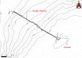
Southeast (Cerro de los Bueyes). Cerro de los Bueyes shows fewer lateral platforms but is dominated by the Berghes Stairway—a monumental stair with intermediate landings that climbs from a rectangular base platform (22 × 13 m, 2,268.64 masl), widens and briefly deviates eastward mid-slope (likely following bedrock/landslide constraints), then resumes a straight bearing to its upper compound (Figure 8). The final preserved flight reaches ∼2,303.32 masl; total vertical difference from the base to the topflight is ∼82.94 m. The summit block (11.52 × 17.46 m) shows looting but retaining wall construction and bedrock-keyed steps are evident. Platform construction here follows a consistent system: stone coursing set against bedrock, fill leveling behind, and retaining walls to stabilize slope faces. Stair-linked benches on the south and southeast flanks carry additional alignments and platform fragments, consistent with staged ascent and segmented access.
Topographic plan of the Southeast sectors on Cerro de la Cruz, highlighting the Berghes Stairway descending the ridge to the terminal pyramid complex.

Figure 8 Long description
The map displays contour lines indicating elevation changes, with the Berghes Stairway marked prominently. The stairway descends along the ridge, leading to a terminal pyramid complex. Elevation markers are visible along the stairway path. A compass rose indicating north is present in the top right corner. A scale bar at the bottom left shows measurements in meters.
Southwest sector. The SW benches preserve large platforms with substructures and scattered alignments, often masked by vegetation and anthills. Domestic compounds dominate the readable planforms; mapping is complete for the main benches, with infill planned for the deferred subsectors at the close of the rainy season.
Feature inventory and distributions
Across mapped sectors, formal sunken plazas/patios cluster on stable benches, especially in the NW and Central sectors, with double-wall precincts and occasional central altars (Figure 9). Summit compounds and stair-organized circulation create a vertical sequence from domestic terraces to formal audience spaces. Residential units range from single-room rectangles to multiroom compounds with triple walls; wall cores are predominantly unshaped rhyolite/basalt/limestone cobbles with opportunistic use of bedrock lips as foundations. The measured sunken plaza set at CDB spans ∼112.77–729 m2 (Table 1), with the largest single example (Central F) at 27 × 27 m (729 m2). The distribution—dense patio fields in the boquilla, stair-linked precincts upslope—matches Súchil-branch hilltop planning and the frontier logic of managed visibility and staged movement. These formal compounds provide the architectural core against which the lighter, hut-like Loma San Gabriel (LSG) foundations on outer benches and boquilla margins can be read as peripheral residential belts within the same hilltop system.
Detail of the Central sector plan showing the cluster of structures surrounding the rectangular feature interpreted as a probable ball court.

Figure 9 Long description
The map displays contour lines indicating elevation changes and a cluster of structures. In the center, there is a label 'Possible Ball Court'. A scale bar is present at the bottom left, showing measurements in meters, ranging from 0 to 50. In the top right corner, a compass rose indicates the north direction.
A probable ballcourt (I-shape variant; alley 14.79 m) is tentatively identified on the central sector. Side embankments are low but continuous; terminals are open. Given erosion and vegetation, we mark it as provisional pending trenching. These patterns in formal architecture and circulation provide the framework against which the lighter, hut-like Loma San Gabriel features must be read: as potential peripheral residential belts and marginal stations positioned in relation to the same stair-linked courts.
Sunken plazas and architectural diversity
Two functional classes of sunken plazas are inferred from plan associations: (1) double-walled courts with central altars (ceremonial/elite precincts), and (2) courts without altars (administrative/residential adjacency). Table 1 summarizes measured examples:
Summary of sunken plaza sizes at CDB

Table 1 Long description
The table provides dimensions and areas of various sunken plazas at CDB, categorized by sector. In the NW sector, Patio B is the largest with an area of 688.50 square meters, while the Internal block is the smallest at 144 square meters. In the Central sector, Plaza F is the largest with an area of 729 square meters, and Plaza B is the smallest at 112.77 square meters. Overall, the Central sector features a wider range of plaza sizes compared to the NW sector. The data highlights significant variations in plaza sizes, which may influence their usage and capacity.
Together with the Berghes and Foster staircases and summit compounds, this suite constitutes the clearest evidence at CDB for stair-organized circulation, bench-anchored audience spaces, and proximate domestic ritual—an ensemble that will be formalized in the comparative plaza/patio analysis that follows.
Loma San Gabriel “hut-like” features (arch-typology)
Beyond the monumental compounds, our mapping documents numerous small, low-rise foundations—typically oval to subrectangular, with single-course wall lines that often do not close—dispersed across outer benches and in interstitial pockets of the boquilla (median footprints ≈ 3–5 m on a side) (Figure 10). Similar small square, rectangular, and circular bases occur in peripheral residential belts without apparent ties to major plazas or courts, reinforcing their stand-alone character. Several clusters lie along circulation routes that connect platforms to major stairways (e.g., the ascent toward Cerro de los Bueyes), situating these features at the margins of processional movement rather than within formal compounds (Figure 11). Taken together, their small footprints, light wall construction, and placement on outer benches and boquilla margins support our treatment of them as LSG-type dwellings or activity stations rather than as simply eroded Chalchihuites-style rooms. In the interpretive sections that follow, we use the clustering, access paths, and architectural investment of LSG-type foundations as the main empirical basis for our social-stratigraphy expectations (S1–S3): peripheral co-residence, shared public spaces, and differential domestic investment.
Map of Cruz de la Boca showing the locations of the “Loma San Gabriel” hut-like foundations in relation to the main hilltop complex.

Figure 10 Long description
The map displays the topography of Cruz de la Boca, highlighting the locations of the 'Loma San Gabriel' hut-like foundations in relation to the main hilltop complex. Contour lines are visible, indicating elevation changes. A site protection region is outlined with a red boundary. The map includes a scale bar and a north arrow for orientation. Various symbols mark specific locations within the outlined area.
Plan of the La Boquilla depression margins, showing “Loma San Gabriel”-style hut-like foundations (in red) near the excavation location and their spatial relationship to the ceremonial hilltop and Chalchihuites-style sunken plazas.

Figure 11 Long description
The map illustrates the La Boquilla depression margins, highlighting various features. Near the top left, the ceremonial hilltop is marked. The excavation location is centrally positioned, with nearby 'Loma San Gabriel'-style hut-like foundations indicated in red. Below this, the map shows Chalchihuites-style sunken plazas. Contour lines depict the terrain and a scale is provided at the bottom left, ranging from 0 to 50 meters. A compass rose is located at the top right.
Excavation: Emergency intervention in a looting context
Given the widespread and systematic nature of looting at Cruz de la Boca, the team conducted a controlled excavation of a recently opened looting pit. This intervention was not originally planned but was deemed necessary due to the visibility of archaeological materials and the stratigraphic integrity still present in situ. The aim was to recover data that would otherwise be permanently lost and to document the impact of illicit excavation activities.
The selected looting pit was located at the center of a quadrangular domestic structure. Several factors guided the decision to excavate this particular context: the pit’s recent disturbance, its central placement within a household unit, the visibility of stratigraphy and architectural features, the imprint of a missing vessel likely associated with a burial or offering, and the exposed human and ceramic materials. This looting pit, situated in a high-priority area, provided an opportunity to recover critical data, especially since such pits often destroy important information.
Following georeferencing with a total station, the structure was divided into four excavation units based on existing architectural alignments. However, due to time constraints and the urgent nature of the intervention, only three of the units were excavated, focusing on areas with the most potential for data recovery.
The looting pit reached a maximum depth of 89 cm and revealed valuable information about the domestic structure’s construction and use. Excavation proceeded by stratigraphic levels, documenting the pit’s profile, soil color, and texture using the Munsell chart. Soil was carefully screened, and disturbances such as animal burrows and plant roots were noted. Materials recovered during excavation, including ceramics, lithics, and faunal remains, were bagged and labeled for laboratory analysis. Human remains were documented with sensitivity to their preservation conditions, and any evidence of secondary disturbance was considered during analysis.
The structure’s walls were constructed using rounded granite cobbles and basalt slabs, with minimal evidence of mortar. However, clay cement patches were found near the floor level. The structure showed a deviation of 16° northwest from cardinal alignment.
Four distinct stratigraphic layers were recorded in Unit 1:
• Layer I: surface compacted soil (12 cm) with a low density of artifacts.
• Layer II: orange, soft soil (14 cm), rich in ceramics (black-on-red esgrafiado), lithics (including a flint projectile point), and human bone fragments.
• Layer III: dark, friable fill, likely used for floor leveling; high ceramic density and continued rodent disturbance.
• Layer IV: light brown compact layer, likely floor preparation, with a partial stone floor and minimal artifacts.
Two human burials were identified during the excavation:
• Unit 2 Burial: an infant aged 2–3 years, found in the northeast corner of the room. The burial was in primary context, oriented north, and placed in a prone position. Given its fragility, it was removed as a block for lab analysis.
• Unit 3 Burial: poorly preserved cranial fragments and faunal remains suggest a possible secondary burial or disturbed primary interment. Proximity to a rodent tunnel complicates the interpretation. The lack of stones or delimiters suggests either a cultural practice or post-depositional disturbance.
Both burials were found at similar stratigraphic levels, suggesting contemporaneity and a common ritual horizon. The absence of formal cysts or delimiters may reflect specific cultural burial practices or the effects of post-depositional processes (Figure 12).
Plan and profile of the excavation unit at Cruz de la Boca. Unit grid shows the positions of Burial 1 and Burial 2; A–A′ profile line corresponds to the north–south trace in plan.

Figure 12 Long description
The image consists of two diagrams. The left diagram shows the profile of a test pit labeled 'Profile - Test Pit - Unit 1'. It includes five layers labeled from top to bottom as Layer 1, Layer 2, Layer 3, Layer 4 and Layer 5, with a section marked 'No Excavated' and 'Bedrock' at the bottom. The right diagram is a plan view of the excavation unit at Cruz de la Boca, showing the positions of Burial 1 and Burial 2. The A–A′ profile line corresponds to the north–south trace in the plan. The diagrams include a scale for reference.
The excavation of the looting pit at Cruz de la Boca provided critical information about the domestic structure’s construction and use, as well as important insights into the site’s burial practices. Despite the challenges posed by looting, animal disturbances, and time constraints, the intervention allowed for the recovery of significant archaeological materials, including human burials, ceramics, lithics, and faunal remains. This data will contribute to a better understanding of the site’s role in the broader regional archaeological landscape.
Archaeological materials
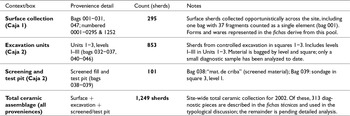
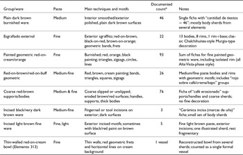
Surface ceramics (Table 2) are dominated by Alta Vista phase (ca. a.d. 600–850) painted geometric wares
Summary of ceramic material (surface and excavation), 2002 season

Table 2 Long description
The table summarizes the ceramic material collected during the 2002 season, detailing the provenience and count of sherds. A total of 1,249 sherds were collected, with the majority, 853, coming from controlled excavations in Units 1 to 3 across three levels. Surface collections yielded 295 sherds, gathered opportunistically across the site. Screening and test pits contributed 101 sherds, with screened material and a sondage in square 3, level I. Of the total assemblage, 313 diagnostic pieces have been analyzed and are included in typological discussions, while the rest await further analysis. This distribution highlights the predominance of excavation-derived materials in the collection.
(red-on-cream/orange; black-on-red), with esgrafiado/sgraffito and incised/impressed minorities; the Murgia inciso-esgrafiado type is present and aligns with Chalchihuites stylistic practice (Lister and Howard Reference Lister and Howard1955; Strazicich Reference Strazicich1998). Rim profiles range from divergent to convergent and elongated forms. Lithics show widespread chert/jasper/obsidian debitage and tool fragments, with higher densities in western and northeastern subsectors; tool debitage ratios suggest localized reduction/maintenance loci. Ground stone is overwhelmingly dacite (manos/metates/polishers), with secondary rhyolite/tuff—consistent with local provisioning and the durability requirements of heavy-use grinding (Figure 13).
(A–F) Selected diagnostic ceramics from Cruz de la Boca: (A) Murgia inciso-esgrafiado fineware, (B, E, F) Alta Vista-phase painted geometric red-on-cream/red-on-buff fineware, (C) plain dark brown “Nails” bowl fragment, (D) Terracotta figurine.

Figure 13 Long description
The image A shows Murgia inciso-esgrafiado fineware, consisting of three ceramic fragments with incised designs. The image B shows Alta Vista-phase painted geometric red-on-cream/red-on-buff fineware, featuring three fragments with geometric patterns. The image C shows a plain dark brown “Nails” bowl fragment with a textured surface. The image D shows a terracotta figurine with a blurred section, accompanied by a scale bar. The image E shows Alta Vista-phase painted geometric red-on-cream/red-on-buff fineware, displaying a large ceramic piece with a smaller inset fragment, both with geometric designs. The image F shows Alta Vista-phase painted geometric red-on-cream/red-on-buff fineware, featuring a single fragment with intricate geometric patterns. Each sub-image includes a scale bar indicating measurements from zero to five centimeters.
Ceramics
The preliminary analysis of ceramics from Cruz de la Boca, carried out at the INAH Zacatecas following the 2002 field season, emphasized typological classification, decorative styles, and surface treatments. A total of 1,249 ceramic fragments were collected, primarily from the site’s surface and looting pits, and were subjected to standard archaeological processing to establish a foundational chronology, assess technological practices, and interpret cultural affiliations.
The ceramics were categorized by general morphological components such as rims, bodies, bases, handles, and supports, and were primarily surface finds. These artifacts displayed a wide range of surface treatments, including burnishing, smoothing, and polishing, as well as diverse decorative techniques encompassing painted, incised, and esgrafiado (sgraffito) motifs. The ceramic paste ranged from fine to medium in texture, typically tempered with small white or black mineral inclusions. While some surfaces showed refined finishing techniques, others appeared rough or weathered, suggesting a variation in function and workmanship quality.
Decoration played a significant role in classification. A large number of rim and body sherds bore painted designs in red, black, and cream, commonly forming geometric motifs such as triangles, zigzags, circles, and linear patterns. These were often executed in combinations like red-on-cream, red-on-orange, or black-on-red, with color references including 10 YR 4/8 (red), 7.5 YR 6/4 (light brown), and 2.5 YR 6/4 (cream), among others. A notable group of sherds exhibited sgraffito decoration, characterized by engraved patterns etched through a surface slip to reveal contrasting underlayers. These designs—typically red-on-brown, black-on-red, or brown-on-orange—were applied to fine paste vessels with minimal white tempering. Additionally, a subset of ceramics displayed incised decoration, including fingernail impressions and linear carving, often on more coarsely finished pieces. Some of these also featured combined incised and painted motifs.
Rim profiles showed considerable variation, with divergent, convergent, and elongated forms being documented, some bearing painted decoration and others left plain. These rim shapes serve as essential elements for typological classification and inference of vessel function. One particularly important specimen, element number 313, was a thin-walled bowl with red and cream geometric designs that included rounded fret patterns and horizontal bands, suggesting a high level of craftsmanship.
Based on the assemblage characteristics, several preliminary ceramic groups can be proposed. The Painted Geometric Ware category encompasses the majority of red-on-cream and red-on-orange sherds with angular decorations. The Esgrafiado Tradition appears to show stylistic links with the broader Chalchihuites horizon, featuring finely incised exterior motifs. Coarse Utility Ware is characterized by undecorated or minimally ornamented ceramics, typically linked to domestic and utilitarian activities. The Incised and Impressed Ware category includes ceramics that may have held symbolic or ritual value, possibly used in ceremonial contexts or as display items (Table 3).
Diagnostic ceramic wares, pastes, and decorative techniques from analysed 2002 surface assemblage at Cruz de la Boca

Table 3 Long description
The table presents diagnostic ceramic wares, pastes, and decorative techniques from a 2002 surface assemblage at Cruz de la Boca. It lists eight groups of wares, with painted geometric red-on-cream/orange ware being the most prevalent, documented 93 times, characterized by burnished surfaces and geometric motifs. Coarse red-brown supports/bodies follow with 76 counts, noted for their eroded surfaces and lack of fine decoration. Plain dark brown burnished ware and esgrafiado external ware are also significant, with 46 and 22 counts respectively, showcasing different decorative techniques. The table highlights the diversity in paste types, ranging from medium to fine, and the variety of motifs, including geometric bands, triangles, and incisions. The data suggests a rich variety of ceramic styles and techniques, indicative of cultural influences and practices at the site.
The ceramic corpus from Cruz de la Boca demonstrates a broad range of production techniques, decorative conventions, and probable uses. The prevalence of formally decorated wares suggests the presence of long-distance stylistic influences and participation in wider cultural exchange networks, particularly with the Chalchihuites tradition. At the same time, the ubiquity of utilitarian wares points to settled habitation and routine domestic activity. These early findings, such as those reflected in the assemblage from the Alta Vista Phase (ca. a.d. 600–900), provide a foundation for ongoing research. As future excavations incorporate stratigraphic and contextual data, this typological framework will be further refined to construct a more nuanced understanding of the site’s chronology and socioeconomic organization.
In terms of relative frequency, painted ceramics with geometric motifs are the most prevalent in the assemblage, indicating a strong and consistent decorative tradition. Sherds with sgraffito and incised designs, although less common, suggest specialized functions and perhaps higher status or ceremonial usage. A substantial proportion of the ceramics consists of basic structural fragments—rims, bases, and bodies—many of which feature burnished finishes, reflecting their role in everyday domestic life. Finally, a smaller portion of the material remains unclassified, either due to extensive erosion or the lack of diagnostic features.
In short, CDB’s ceramics fit within the same northern frontier ceramic and mineral economy that materialized Epiclassic social differentiation and interregional interaction from the Malpaso Valley to the Guadiana basin. Positioning CDB’s assemblage against this backdrop (Córdova 2006; Kelley and Bell Reference Kelley1974; Martínez 2007; Nelson and Martin Reference Nelson, Canchola, Luis Punzo Díaz and Minnis2015; Pomedio et al. 2013; Punzo Reference Punzo Díaz2016; Sandoval 2011; Strazicich Reference Strazicich1998; Turkon et al. 2018; Vidal Aldana 2017) foregrounds the interplay between local production and broader stylistic and economic networks—again reinforcing our emphasis on the layered character of frontier interaction.
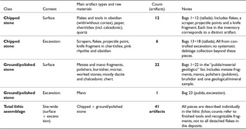
Lithics and ground stones
The lithic assemblage from Cruz de la Boca comprises both chipped and ground stone artifacts distributed across multiple surface sectors. A spatial analysis of the chipped stone materials reveals that the W1 and W2 exhibit the highest concentrations of lithic artifacts. These areas likely functioned as primary zones of tool production or intensive activity, perhaps related to subsistence tasks such as hunting and butchering. The Southwest-Central sector also shows a moderate number of lithic remains, suggesting it may have served as an intermediary or transitional space between domestic and productive zones. This distribution indicates a patterned use of space and possible specialization by sector, a hypothesis that will benefit from further stratigraphic excavation.
Material analysis of ground stone artifacts shows a clear dominance of dacite, which appears in the vast majority of manos, metates, and polishers recovered. This prevalence likely reflects either the natural abundance of dacite in the region or its desirable properties for grinding and wear resistance. Secondary materials include rhyolite and rhyolitic tuff, which are represented less frequently but still play a role in the ground stone toolkit.
In terms of typology, the chipped lithic assemblage is dominated by projectile points and flakes, which collectively suggest an emphasis on hunting activities and tool maintenance or production. Projectile points, often made of chert, jasper, or obsidian, include both complete and fragmentary specimens and demonstrate a variety of forms and reduction stages. Flakes—many of which show signs of retouch or reuse—represent the by-products of toolmaking and occasional expedient tools in their own right. Miscellaneous artifacts form a significant portion of the collection, encompassing undiagnostic fragments, production debris, and unidentifiable worked pieces. This category reflects either fragmentation from post-depositional processes or a diversity of artifact forms beyond those typically typologized (Table 4).
Summary of lithic material (chipped, ground, and other stone), 2002 season

Table 4 Long description
The table summarizes lithic materials from the 2002 season, detailing chipped and ground/polished stones found on the surface and through excavation. A total of 41 artifacts were documented, with the majority being ground/polished stones (22) found on the surface. Chipped stones, mainly obsidian, jasper, and chert, accounted for 12 artifacts from the surface and 6 from excavation. Ground/polished stones included metate and mano fragments, polishers, and a burnisher, mostly made of dacite and chalcedonic chert. The data highlights a greater presence of ground/polished stones compared to chipped stones, with all artifacts individually described in the lithic fichas. The counts focus on finished tools and recognizable fragments, excluding detached flakes.
The preliminary analysis underscores both functional diversity and spatial patterning in the use and production of lithic tools at Cruz de la Boca. Ground stone tools indicate long-term domestic occupation with a focus on processing vegetal resources, while chipped stone artifacts reflect subsistence and possibly defensive practices. Continued analysis, including microscopic wear studies and sourcing, will refine these interpretations and shed further light on the technological strategies employed by the site’s inhabitants (Figure 14).
CDB Lithics (A) Small bifacial arrow points (triangular side-notched, stemmed and lanceolate forms) in chert/jasper/chalcedony, (B) Grey obsidian scraper on a macroflake, (C) Miniature chalcedony pendants or beads ornaments.

Figure 14 Long description
The image A shows small bifacial arrow points in various shapes, including triangular side-notched, stemmed and lanceolate forms, made from materials like chert, jasper and chalcedony. A scale indicating 0 to 3 centimeters is present below the points. The image B shows a grey obsidian scraper on a macroflake with a similar scale below it. The image C shows miniature chalcedony pendants or beads, with a scale from 0 to 3 centimeters below them.
Social stratigraphy and general site organization: Loma San Gabriel Belts in a hierarchical landscape
In what follows we move from description to interpretation, structuring the discussion around expectations S1–S4. One possibility is a classic stratified hierarchy, in which LSG households form a structurally lower tier—lighter architecture on outer benches, reduced access to finewares, and perhaps a stronger emphasis on certain labor or subsistence tasks—while still sharing public courts with core residents. A second possibility is a more heterarchical or segmentary configuration, in which LSG and core households differ architecturally and materially but represent parallel or complementary corporate groups rather than simple “upper” and “lower” ranks. A third possibility is a dual or multicommunity frontier enclave, in which LSG features correspond to more mobile groups who use CDB’s courts episodically while maintaining primary bases elsewhere.
In this article we present first-order, largely qualitative spatial tests of S1–S3, based on mapping, architectural classification, and surface assemblages; S4 remains primarily a programmatic expectation, to be evaluated when excavations in LSG clusters become available. Our analysis cannot yet fully resolve among all possible models, but it specifies how CDB’s spatial and material record can be used to do so. By treating the distribution of LSG structures, their access to public spaces, their architectural investment, and, eventually, their household ritual practices as components of a social stratigraphy, we shift discussion of Loma San Gabriel from broad typological labels to a framework grounded in spatially explicit, replicable expectations about how different groups interacted in the same built landscape.
Core courts, stairways, and the scripted middle
At the center of the mapped nuclear zone lies the boquilla, a gently inclined saddle between Cerro de la Cruz and Cerro de los Bueyes where structural density peaks. Here, sunken courts and patio-banquette compounds concentrate on the most stable benches. The largest measured courts in the Central sector (e.g., 26 × 17 m and 27 × 27 m; ≈442–729 m2) are laid out to admit sizable audiences, while courts with double perimeters and central altars tighten architectural focus and restrict circulation along their lips.
This middle zone is the site’s principal civic hinge, where domestic ranges, terraces, and courts are interleaved. Short stair segments and platform lips connect compounds, allowing people to move laterally across the saddle and vertically into slightly elevated benches. Even without head counts, the relative sizes and degrees of enclosure point to a basic distinction: more generous courts and open platforms in the boquilla for larger and mixed audiences, and more tightly walled spaces as one ascends toward benchtop precincts on both hills.
From this middle, two major stair systems, the Foster Staircase on Cerro de la Cruz and the Berghes Stairway on Cerro de los Bueyes—convert vertical relief into social differentiation. Each stair translates steep slopes into sequences of landings and turns that stage bottlenecks and vistas. The Foster Staircase links foothill platforms to a series of upper benches with three formal sunken plazas/patios (A–C). The Berghes Stairway climbs from a rectangular base platform through intermediate landings to a summit compound, deviating mid-slope around bedrock or landslip anomalies before resuming a straight ascent.
In functional terms, these stairways are filters rather than mere connectors. Each step uphill reduces the number of people who can comfortably ascend, while landings and turns frame partial views of the boquilla and opposite hill. Benchtop compounds, smaller courts, and double-bounded precincts at higher elevations represent a contraction of audience envelopes and an intensification of selective access. The vertical sequence from boquilla to upper benches thus encodes a rank gradient: more inclusive gatherings below, more restricted settings above.
Loma San Gabriel belts: Peripheral, but not distant
Within this same landscape, small, light-built structures provisionally grouped as Loma San Gabriel (LSG) sensu lato (Figure 15) form a complementary pattern. These are low-rise foundations—oval, subrectangular, or small quadrangles—with single-course wall lines that often do not close and median footprints on the order of 3–5 m per side. They occur on:
• Outer benches flanking the main courts;
• Interstitial pockets along the margins of the boquilla, and;
• Segments of circulation routes that connect platforms to the major stairways (e.g., along the ascent toward Cerro de los Bueyes).
Loma San Gabriel (LSG)-type and Chalchihuites-style domestic architecture at Cruz de la Boca (CDB). Schematic reconstructions contrast a subrectangular, single-course LSG foundation (left) with a higher-investment Chalchihuites domestic room with thicker masonry and prepared floor surfaces (right).

Figure 15 Long description
The image shows a schematic comparison of two architectural styles. On the left, a subrectangular, single-course Loma San Gabriel foundation is depicted with an interior space and packed earthen floor. On the right, a Chalchihuites domestic room is shown with thicker masonry and a paved floor. Below the schematics, a landscape photo displays a rocky path in a natural setting, labeled as Loma San Gabriel foundation.
Crucially, these LSG features are concentrated in peripheral belts and clusters, not dispersed randomly across the massif. In the Central sector, for example, small LSG-type bases appear along the west margin of the boquilla and in pockets where the terrain steps down from the main patio fields. On Cerro de la Cruz and Cerro de los Bueyes, they dot outer benches below or to the side of the better-built patio-banquette compounds and summit precincts.
Measured purely in meters, the LSG clusters are close to formal courts and stairways: in many cases within a short walk and in clear line of sight. Yet in architectural terms they are clearly distinct from the multiroom, thick-walled compounds and sunken courts. Their light construction and location on secondary benches place their inhabitants at the edges of the main ritual and circulation spaces, not inside them.
This combination—proximity in space, distance in architectural investment—is the core empirical basis for treating LSG structures as a separate layer in the site’s social stratigraphy. LSG households were not parked in some distant camp, nor were they folded seamlessly into the main compounds. They occupied peripheries that fringe and feed the core.
Proximity to ritual spaces and access to the courts
If we consider distance and access rather than only plan views, the LSG pattern is still more suggestive. Several LSG clusters lie along routes that connect outer benches to the boquilla and to the base platforms of the major stairways. From these clusters, movement into the main courts requires only modest vertical gain and no obvious architectural barriers. In other words, LSG residents could reach the principal public spaces via the same least-cost corridors used by residents of heavier patio-banquette compounds.
At the same time, there is little evidence that LSG structures form part of the compound walls that immediately flank altarized courts or summit precincts. Instead, they sit just outside these core ensembles, often in zones with more flexible circulation and fewer built boundaries. This suggests a shared arena of ritual observation and participation, but differentiated points of departure and return:
• Core compound residents live inside the densest stair-court circuitry, with doors and terraces opening directly onto major courts and stair landings.
• LSG residents live beside and below that circuitry, on benches and margins that open onto the same paths and vistas but without the same architectural thickness or enclosure.
In practical terms, LSG households could see and hear events in the courts, join processions, and traverse the same approach routes, yet their domestic architecture was not itself “plugged into” the thickest nodes of ritual circulation. Proximity to ritual spaces was good enough for participation, but not equivalent in structural privilege.
Social stratigraphy: Co-resident fields of practice
These spatial relations—core compounds in the boquilla and upper benches, LSG belts on outer margins with ready access to the same courts—are consistent with a model of co-resident but unequally positioned groups. In terms of social stratigraphy, the hilltop is organized not as a simple vertical stack of ranks, but as a field of practice in which:
• The heaviest investment in walls, terraces, and altarized courts concentrates where visibility and circulation are most intensely managed (boquilla courts, benchtop precincts, summit compounds).
• Lighter investment in hut-like structures clusters around these nodes on benches that remain within earshot and sightline, but at one remove from the main thresholds and terraces.
In this reading, LSG households occupy a peripheral position in the local social field: they are structurally close to, and oriented toward the same public arenas as core residents, yet their housing and spatial rights do not embed them in the key architectural ensembles that define the site’s ritual and political center. They are participants, not outsiders; but they are not equivalent participants.
The architecture alone cannot tell us whether this difference reflects “lower status,” “more mobile lifeways,” “attached specialists,” or some combination thereof. What it does show is that CDB’s hierarchy is not only vertical (boquilla vs. benches vs. summits), but also horizontal, across belts of unequal domestic investment that ring shared courts.
Material culture, domestic practice, and future tests
Material distributions reinforce this picture in broad strokes. Decorated finewares and esgrafiado sherds—stylistically linked to the Alta Vista Phase—occur with higher frequency near formal circulation lines and courts, while coarse utilitarian wares and heavily worn dacite ground stone are widespread across domestic benches. Chipped-stone densities peak in western and northeastern subsectors, where some LSG clusters are present, suggesting localized zones of tool reduction and maintenance.
At present, the only excavated domestic structure is a quadrangular room bordering a sunken patio, with carefully prepared floor sequences and intramural burials. Its construction and ritual signatures align it with the better-invested segment of the domestic spectrum. Targeted testing of LSG structures will be required to determine whether they share similar intramural practices or instead exhibit a different ritual profile—an issue taken up in the methodological expectations (S3–S4) and in the concluding discussion.
For now, the combination of:
• Core clustering of heavy compounds and sunken courts on stable benches;
• Peripheral concentration of LSG huts on outer benches and boquilla margins, and;
• Shared but asymmetrical access to the same courts and stairways
supports a model of Cruz de la Boca as a socially stratified hilltop where distinct residential groups cohabited a common ritual arena. LSG households were not marginal in the sense of being spatially excluded; they were marginal in terms of where they lived relative to the thresholds that mattered most.
In that sense, the site’s organization makes Loma San Gabriel belts and clusters central to understanding hierarchy at CDB. They are not residual “chozas” on the map’s periphery; they are the architectural trace of how the hilltop’s core and margins were stitched together in everyday movement and occasional gatherings.
Read through the lens of frontier interaction and field theory, Cruz de la Boca’s layout suggests not a simple opposition between “Chalchihuites farmers” and “Chichimec foragers,” but a shared hilltop field of practice in which distinct groups occupied different positions within the same architectural grammar. Core patio-banquette compounds, sunken courts, and summit precincts represent positions with greater control over visibility, thresholds, and ritual pacing, while Loma San Gabriel belts on outer benches mark positions whose domestic investment is lighter but whose everyday movement remains oriented toward the same courts and stairways. In Bourdieu’s terms, the hilltop reads as a structured space of positions in which access to symbolic capital—encoded in altarized courts, double walls, and stair-bench chokepoints—is uneven, yet all positions are defined relationally within the same cultural field rather than across a hard ethnic divide.
When considering the long-standing debate over Loma San Gabriel, the Cruz de la Boca pattern is significant because it does not fit comfortably into either extreme position. On the one hand, the recurrent clustering of small, lightly built foundations on outer benches supports the idea that these were not simply random, degraded, or residual versions of core Chalchihuites compounds. On the other hand, their close articulation with the same courts, stairways, and sightlines used by heavier compounds warns against treating them as wholly separate enclaves detached from the site’s principal civic and ritual spaces. In that sense, CDB is best understood as evidence for a frontier formation in which co-resident groups occupied unequal positions within a shared hilltop field. This reading preserves Kelley’s emphasis on local traditions interacting with Chalchihuites while also taking seriously Hers’s caution that architectural contrast may register social differentiation as much as cultural difference.
This configuration fits comfortably within Peer Polity Interaction and northern “world-system” models, but it does so at a finer grain. Rather than treating CDB simply as a node in long-distance prestige networks, the LSG core contrast shows how interpolity competition and emulation were grounded in intrasite differentiation. The same sunken courts and stairways that materialized CDB’s participation in wider Chalchihuites architectures also choreographed unequal participation within the community: some households lived inside the thickest nodes of circulation, others in peripheral belts that nonetheless shared the public stage. The frontier, in this view, is not only a macroscale interaction belt between centers and foragers; it is also a set of internal frontiers on the hilltop itself, where different lifeways and degrees of attachment to the ceremonial core are negotiated through residence and movement.
Our expectations S1–S4 formalize this reading as a set of testable predictions rather than a narrative flourish. If CDB’s social stratigraphy is indeed organized around co-resident but unequally positioned groups, we expect (S1) LSG clusters to remain systematically peripheral yet proximate to core courts and stairways, (S2) access paths from LSG belts to public arenas to mirror, rather than bypass, principal circulation routes, (S3) architectural investment and maintenance histories in LSG dwellings to diverge from those of core-area rooms, and (S4) domestic and ritual signatures—ceramic finewares, feasting residues, intramural burials—to show graded differences rather than a simple presence/absence dichotomy. Future excavations in LSG clusters and finer-grained mapping of surface assemblages will allow these expectations to be falsified or refined, anchoring debates over “Chichimec” and “Mesoamerican” interaction in the lived spatial hierarchies of a single, shared hilltop.
Conclusions
This first publication establishes a reproducible spatial baseline for Cruz de la Boca and reframes the site as a socially stratified hilltop rather than simply a monumental Chalchihuites center. Georeferenced mapping of ∼15 ha across four sectors documents a dense core of sunken patio-banquette compounds in the boquilla, stair-organized ascents to benchtop and summit precincts on both hills, and peripheral belts of light, hut-like Loma San Gabriel (LSG) foundations on outer benches and saddle margins. Together, these elements show how movement, visibility, and domestic investment were orchestrated in a single built landscape that sorted people and practices without segregating them into wholly separate enclaves.
Our strongest current contributions are therefore twofold. First, we provide a high-resolution, georeferenced plan of an underpublished Súchil-branch hilltop, making CDB directly comparable to better-known centers such as Alta Vista and La Quemada. The mapped pattern of dense core compounds, stair-linked courts, and LSG belts on outer benches anchors future work on settlement size, plaza metrics, and circulation hierarchies. Second, we advance an explicit, testable framework of social stratigraphy—expectations S1–S4—that links architectural position, access to public spaces, domestic investment, and household ritual to models of co-resident but unequally positioned groups.
Within this landscape, LSG belts are crucial: they are not incidental hut-like residues but a second layer in the site’s social stratigraphy. Their small footprints, single-course walls, and placement on peripheral benches at the edges of main courts and stairways point to co-resident groups who shared the same public arenas yet occupied different structural positions within the hilltop field. In contrast, core patio-banquette compounds and summit precincts concentrate the heaviest architectural investment, the tightest control of thresholds, and the closest embedding in altarized courts and stair chokepoints. The emergency excavation of a domestic room adjacent to a sunken patio—documenting prepared floors, local cobble construction, and intramural burials—provides a baseline for higher-investment core households, while ceramic and lithic distributions underline the familiar frontier pattern of local provisioning in heavy architecture and ground stone alongside participation in broader Chalchihuites stylistic networks.
At this stage, our tests of S1–S3 remain primarily spatial and qualitative, while S4—concerning shared ritual horizons or separate ritual worlds—remains programmatic pending excavation of LSG clusters. Even so, the present study allows one broader conclusion. Cruz de la Boca shows that the Loma question matters because lightly built peripheral residences are not incidental residues on the margins of a Chalchihuites-style center; they are patterned components of the hilltop’s organization and therefore central to understanding how northern frontier communities were composed. The recurrent association of dense core compounds, stair-linked civic spaces, and peripheral LSG-type belts suggests that frontier dynamics at CDB were not structured by absolute separation between “Mesoamerican” and “Chichimec” worlds, but by co-presence, asymmetrical access, and negotiated participation within the same built landscape. In that sense, CDB contributes to the long-standing debate not by resolving it completely, but by showing that Loma San Gabriel is best approached as an archaeological problem of social position, interaction, and historical entanglement rather than as a minor typological appendix.
Better mapping matters to that larger northern frontier question because it makes such relationships visible and testable. The georeferenced plan presented here does more than document an underpublished Súchil-branch hilltop: it provides a reproducible spatial basis for asking how local traditions, Chalchihuites institutions, and frontier inequalities were articulated in practice. By placing LSG-type foundations, courts, stairways, and domestic compounds within the same coordinate framework, Cruz de la Boca becomes relevant not only as a mapped site, but as evidence for how the northern frontier worked as an interaction field in Kelley’s sense—one influential enough to shape later scholarship under the rubric of the “Chichimec Sea.” Future excavation and quantitative spatial analysis will refine that picture, but the principal contribution of this study is already clear: upgraded mapping does not simply improve site description; it reopens a larger debate about Loma San Gabriel, frontier social formation, and the internal organization of Epiclassic hilltop centers in northwestern Mesoamerica.
Acknowledgements
We thank INAH Zacatecas staff. We also appreciate the constructive feedback of the reviewers and editor.
Data availability statement
Spatial and artifact datasets associated with this study are available upon request, in accordance with INAH policies and site protection considerations.