

In addressing environmental and natural resource problems, there is a move away from primary reliance upon centralized regulation toward assignment of property rights of some sort to mitigate the losses of the “Tragedy of the Commons.”2
Open-access losses were famously described in Garrett Hardin's 1968 Science article, “Tragedy.” The implications of open access, however, had been understood for a very long time. Scott Gordon (“Economic Theory”) described them 35 years earlier, but yet 46 years later, Grafton, Squires, and Fox (“Private Property”), could still describe the dramatic wastes of over fishing and regulation in the Pacific Northwest halibut fishery, and a 2003 Nature article by Myers and Worm, “Rapid Worldwide Depletion,” could report that the world's major predatory fish populations were in a state of serious depletion. A similar conclusion for deep-sea fisheries was reported by Devine, Baker, and Haedrich, “Fisheries,” also in Nature. See Stavins, “Market-Based Environmental Policies,” for discussion of the movement toward market-based instruments.
Tietenberg, “Tradable Permits,” p. 1.
Stavins, “Economic Incentives.”
The advantages of property rights arrangements include better alignment of incentives for investment in the resource, provision of collateral for accessing capital for investment, more flexible exchange, greater information generation, and improved cost savings in meeting conservation or environmental objectives.5
For example, consider success under the Clean Air Act Amendments of 1990 in designing air pollution emission permits for lowering the cost of meeting air quality targets (Tietenberg, “Tradable Permits,” p. 12; and Stavins, “Market-Based Environmental Policies, p. 4, and “Economic Incentives,” pp. 6–13). Alston, Libecap, and Schneider (“Determinants”) describe the importance of title for land use and long-term investment on the Amazon frontier.
Libecap, Contracting for Property Rights; and Dahlman, “Problem.”
Despite the attractions of property rights to address some resource and environmental problems, they remain controversial, limiting or slowing their adoption. Allocation especially is contentious because of the assignment of wealth and political influence associated with exclusive property rights. Property rights are political institutions and the underlying negotiations determine the nature of the rights arrangements that ultimately emerge, their timing, and effectiveness.7
See Libecap, Contracting for Property Rights, pp. 10–28.
Coase, “Problem.”
Contemporary policy discussions about crafting responses to the common pool can receive guidance from research in American economic history on the development of property institutions on the frontier. I examine the assignment of private property rights during the nineteenth and early twentieth centuries to five natural resources, mineral land, timberland, grazing and farm land, and water on federal government lands in the Far West. The region was richly endowed with natural resources, but assigning property rights to them required adaptation from established, eastern practices as defined by the federal land laws. The property rights that emerged and their long-term welfare effects provide a laboratory for examining current questions of institutional design to address over-fishing, excessive air pollution, and other natural resource and environmental problems.
As the opening quote by Wallace Stegner suggests, and as we will see, western institutions encountered many of the same information, political, and planning problems that are encountered today. Some were successful, whereas others were not. A major lesson is that property rights allocations that were based on local conditions and prior use and were unconstrained by outside government mandates were most effective in addressing not only the immediate threat of open-access, but in providing a longer-term basis for production, investment, and trade. Western mineral rights stand out in this regard. In contrast, federal government limits on allotment size, use, and exchange had long-term negative consequences. Homestead distributions of 160 acres for farming only are the prime example.
Another lesson is how hard it is to repair initial faulty property allocations. Whereas Coase emphasized transaction costs in private negotiations, political transaction costs are especially important in the assignment and subsequent modification of property rights.9
I am not referring to the exchange of property, but changes in the property allocation rule: who can own, in what amounts, and what can be done with the property.
The private and political transaction costs of assigning and modifying property rights has been the overall thrust of my research as outlined in what follows. For spillover between private and political transaction costs as revealed in efforts to regulate oil production in U.S. states, see Libecap and Wiggins, “Influence.”
ALLOCATION RULES AND TRANSACTION COSTS
There are a number of ways to assign property rights:
First-Possession
First-possession assigns ownership on a first-come, first-served basis or first-in-time, first-in-right. First-possession rules are attractive because they recognize incumbent parties, who have experience in exploiting the resource and hence, may be the low-cost, high-valued users.11
See discussion of first-possession in Epstein, “Possession”; Rose, “Possession”; and Lueck, “Rule” and “First Possession.” Various property regimes are discussed by Ellickson, “Property.” Alston, Libecap, and Schneider (“Property Rights”) find that the original settlers on the more remote Amazon frontier in Brazil had lower opportunity costs than those who came later and who often purchased land from the initial claimants after roads were built and transportation costs to market had declined. The early settlers were younger and had less wealth and education.
On the American frontier, “squatters” moved ahead of the federal land survey. When the land was subsequently surveyed and opened for claiming, “claims clubs” formed to prevent outsiders from encroaching on pre-existing holdings. See Gates, History, p. 152. See also Tietenberg, “Tradable Permits,” p. 10, for contemporary arrangements in resource and environmental cases.
There are other reasons why first-possession rules can be efficient. They recognize first-movers, innovators, and entrepreneurs, who initially experiment with and use a resource. Society benefits from innovative, risk-taking activities. Further, under first-possession the market can determine optimal claim size, whereas under other allocation arrangements bureaucratic or political objectives may define the assignments. If these are not consistent with optimal production size, then further trade is required, and if transaction costs are high, such exchange might be limited. Hence, first-possession can economize on transaction costs.13
See Epstein, “Possession.”
First-possession has been criticized on fairness grounds because it discriminates against new entrants, and existing holdings may be large. There are wide-standing views that “people should get what they deserve and deserve what they get.” If first-possession ownership is viewed as rewarding those who by luck and connections got early access, then it may be opposed politically.14
Alesina and Angeletos, “Fairness,” pp. 960–80. Equity issues in the allocation of property rights or property-like use rights are also the theme of Raymond, Private Rights.
First-possession also has been criticized for leading to rent dissipation if homogeneous claimants race to establish property rights.15
Anderson and Hill, “Race.”
Johnson and Libecap (“Contracting Problems”) show that heterogeneity among fishers limits rent dissipation even under open-access and the rule of capture.
Anderson and Hill (“Race”) criticize the occupancy requirements of the Homestead Act. In contrast, if beneficial use encouraged sorting, homesteaders may have been more likely to have past farming experience and be successful in their endeavors. Hansen and Libecap (“Allocation,” pp. 123–24) do not directly test this proposition, but their data on Eastern Montana homestead failure during drought provide mixed support for it. The data set is small (40 observations) and it shows that previous Great Plains farm experience increased survival chances, a finding consistent with the proposition, whereas farm experience elsewhere in the Midwest lowered survival chances. The type of farming experience mattered. Indeed, those homesteaders who were not from the Great Plains and had no farming experience were more likely to survive drought than those not from the region with farming experience (the wrong kind).
Uniform Allocation
Uniform sharing rules meet egalitarian goals by providing equal-sized allotments or equal opportunities. If there are no restrictions on subsequent exchange of property rights and transaction costs are low, there are few efficiency implications. The resource still migrates to high-valued users and to optimal production sizes. But if exchange costs are high, then inefficiently small (or large) distributions can persist. Uniform allocations, however, avoid the measurement costs of verifying claims of past production or of documenting precedence claims that are part of first-possession assignments. They also can circumvent the costly pursuit of or rush for property rights when first-possession is known to be the allocation rule. They work best when there are no incumbent users whose informal claims may not be consistent with more equal distributions.
Auction
A third allocation mechanism is auction, and there are various types.18
For summary of auction issues, complications, and applications, see McAfee and McMillan, “Auctions”; Milgrom, “Auctions”; and Klemperer, “What Really Matters in Auction Design.”
See discussion by McMillan (“Selling Spectrum Rights”) regarding the experimentation and costs of designing auctions for the spectrum.
Johnson, “Implications.”
Transaction Costs
Property allocations are affected by transaction costs. They arise due to limited and asymmetric information about the open-access problem; the physical nature and value of the resource; and number and heterogeneity of the competing parties.
INFORMATION AND TRANSACTION COSTS
Garrett Hardin asserted that “mutual coercion, mutually agreed upon by the majority of the people affected” in the form of regulations, prohibitions, or property rights would be agreed to because “the alternative of the commons is too horrifying to contemplate. Injustice is preferable to total ruin.”21
Hardin, “Tragedy,” p. 1247.
As Johnson and Libecap (“Contracting Problems”) argue with regard to fisheries, more experienced, “better” fishers may do better under open-access than under regulation that places uniform restrictions on all fishers.
There typically are disagreements about the seriousness of the problem, as well as when and how it is to be addressed. For these reasons, empirical regularities are that most environmental and natural resource commons dilemmas and (ex post) inappropriate institutions are not responded to until late, when the problems have become very serious. By that time, disputes over their magnitudes decrease and the costs of not taking more appropriate actions swamp concerns over the distribution of the costs and benefits involved. Unfortunately, also by that time, many of the resource rents have been dissipated and the environmental losses have been made irreversible.23
For example, see Wiggins and Libecap, “Oil Field Unitization,” regarding the delay in responding to open-access in oil pools. Johnson and Libecap (“Contracting Problems”) point out similar delay problems in fishery regulation.
Moreover, the private and political costs of adjustment can be very high, and the process can take a long time. Once property rights are assigned, individuals make production and investment decisions on the basis of them. Some involve fixed capital investments and other input obligations. Communities and other economic and political constituencies form around these practices and develop expectations for resource use and economic opportunity around them. More appropriate rights allocations may involve very different input mixes and production processes, requiring those who have had a stake in the old arrangement to adjust. But the economic alternatives for them may be very uncertain and limited, fueling political opposition to any change and demands for side payments. These political side payments in themselves change the rights structure that emerges.24
Libecap and Wiggins (“Contractual Responses” and “Influence”) describe how the opposition of small, high-cost oil producing firms to regulations to limit common-pool losses in Texas resulted in favorable, but costly prorationing rules that encouraged dense, deep drilling and that exempted stripper wells from any regulation. Their opposition also blocked state-mandated unitization laws that were adopted in every other oil-producing state. Texas still has no mandatory unitization law.
RESOURCE CHARACTERISTICS AND TRANSACTION COSTS
More mobile or unobservable resources are associated with more uncertainty and with higher measurement and enforcement costs in assigning property rights. As a result, ownership is sometimes granted only to the flow of output (rule of capture) because extraction is more easily measured than is the stock. This is an incomplete assignment of property rights, however, and it can still lead to rent dissipation and premature depletion of the stock.
More valuable resources also are associated with higher enforcement costs because there are more claimants and potential entry. At the same time, as open-access losses increase for valuable resources, the returns to the assignment of property rights rise. Capturing a portion of rents that are saved is the motivation for individual parties to establish ownership institutions.25
See the framework provided by Alston, Libecap, and Schneider, “Determinants,” with regard to the demand for property rights on the Amazon frontier.
Demsetz, “Toward a Theory.”
NUMBER AND HETEROGENEITY OF COMPETING PARTIES AND TRANSACTION COSTS
Both of these factors raise the costs of assigning property rights. The larger the number of claimants, the greater is the potential for free riding, holdup, and defection. In contrast, smaller, more homogeneous groups are better able to find consensus on the allocation of property rights. This suggests that the assignment of ownership to new resources with no pre-existing claimants can occur at less cost than is the case for established resources with heterogeneous incumbent claimants and new entrants. Elinor Ostrom and others have shown that small homogeneous groups with frequent interaction can effectively reach agreement on resource allocation and use.27
Ostrom, Governing the Commons.
AMERICAN LAND POLICY AND THE ALLOCATION OF PROPERTY RIGHTS: THE SPECIAL PROBLEMS OF THE FAR WEST
Early American land policy developed around agriculture with the Northwest Ordinance of 1785, the various Pre-emption acts, other statutes that progressively lowered land prices, and most importantly, the Homestead Act of 1862 and related land laws.28
12 Stat 392. See discussion of federal land laws in Donaldson, Public Domain; Robbins, Our Landed Heritage; Peffer, Closing; Hibbard, History; and Gates, History.
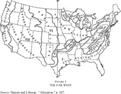
Federal land policy provided an ex ante, systematic framework for surveying, demarcating, and allocating government land to private individuals. The Midwest, where the policy most applied, was characterized by extensive areas of very rich soil, relatively flat terrain, abundant precipitation, and a temperate climate. Through 1880, about the time that the frontier moved beyond the 98th meridian (see Table 1), millions of acres of federal land had been distributed for agricultural use to the states for schools, universities, and internal improvements, to railroads to subsidize their extension, and to individuals through sale, military warrants and scrip, and provisions of the public land laws.29
There is disagreement as to the beginning of the Far West—the ninety-eighth or the hundredth meridian. Webb, Great Plains, chose the ninety-eighth; and Stegner, Beyond the 100th Meridian, the hundredth. Either identifies the onslaught of drier conditions. For the most part, the ninety-eighth meridian is used in this article as the starting point. Gates, History, appendices A, B, and C.
The Far West, however, was at once remote from established federal land policy and at the same time inhospitable to it. There also were different resources, beyond agricultural land, that private claimants desired. Accordingly, when settlers followed the movement of the frontier across the continent, the new conditions they encountered required modification of established property rights policies. This situation allowed for local, private arrangements to emerge that in some cases were incorporated into state and federal law and remain in force today, whereas in other cases, they either were constrained by exogenous formal distributional mandates or never developed officially due to limited information about appropriate production and allotment size. The lingering effects of these varying institutional responses for resource allocation and use were sharply different. They molded the economic history of western regions.

FIGURE 1 THE FAR WEST
MINERAL LAND
The development of private mineral rights on federal land has been more thoroughly examined than for any other western resource. Major works include those by John Umbeck, William Hallagan, Gary Libecap, Andrew Morriss, Richard Zerbe and Leigh Anderson, Karen Clay and Gavin Wright, and James Stewart.30
Umbeck, “Theory,” “California Gold Rush,” and “Might”; Hallagan, “Share Contracting”; Libecap, “Economic Variables” and “Government Support”; Morriss, “Miners”; Zerbe and Anderson, “Culture”; Clay and Wright, “Order”; and Stewart, “Cooperation.”
Western mineral rights developed abruptly with the discovery of gold in 1848 at Sutter's Mill in California.31
Morriss et al., “Homesteading Rock,” p. 748.
Morriss, “Miners,” p. 594; and Umbeck, “California Gold Rush,” p. 214.
Shinn, Mining Camps, pp. 160–62.
Because private mineral rights were based on local negotiations with virtually no outside constraint, the market determined the allotment mechanism and individual claim size, as well as conditions for exchange, maintenance, and enforcement of property rights. For this reason, western mineral rights provide a baseline for comparison with the other property rights arrangements described in what follows.
Mining camp rules were drafted quickly because the number of individuals in each area was small, and they had relatively homogeneous backgrounds and expectations. Further, there were high expected gains of avoiding disruptive conflict over mineral ground. Rules were drafted whenever 20 to 30 prospectors congregated in a new mining district, and Zerbe and Anderson report that in cases the populations were 75-90 percent American or of European origin.34
Zerbe and Anderson, “Culture,” p. 119.
Reid, Law, p. 18.
Umbeck, “Might,” p. 53. In studying oil field unitization efforts Wiggins and Libecap (“Oil Field Unitization”) argue that negotiations are easier when all parties are similarly ignorant about true resource locations and values and that sharing agreements become more difficult when some parties have asymmetric information advantages.
Zerbe and Anderson, “Culture,” pp. 135–36; and Stewart, “Cooperation,” p. 21.
First-possession to a single, specific location of mineral land was the allocation rule.38
Umbeck, “Theory,” p. 436; Morriss, “Miners,” p. 601; and Zerbe and Anderson, “Culture,” p. 133.
Each mining claim had to be marked and worked according to local mining camp rules. For example, one district in 1852 required miners to work their claims at least one day out of three during the mining season, and another in 1853 specified that a miner was to dig a ditch on his claim “one foot wide and one foot deep” within three days of locating a claim.39
Quoted in Kanazawa, “Extralegal Origins,” p. 11; Zerbe and Anderson, “Culture,” p. 132, discuss work requirements.
Naturally, there were disputes over whether a claim was abandoned or whether it was jumped. See McCurdy, “Stephen J. Field,” pp. 243–44.
Indeed, given the uncertainty of the location of ore, prospectors expected to locate and move numerous times before striking it rich, so that they needed a flexible way of obtaining and relinquishing the right to search for ore in any particular place.41
Clay and Wright, “Order.”
Stewart, “Cooperation,” p. 8.
Although there was variation both across the mining camps and across time, mining codes always placed a limit on claim size that varied according to the type and expected value of the claim. Importantly, these claim sizes, however, were determined by local factors, not outside government requirements. Smaller claims were allowed in potentially richer stream beds where gold was thought to concentrate and water for extraction was nearby, whereas larger claims were allowed on drier hill sides that offered lower prospects.43
Zerbe and Anderson, “Culture,” pp. 129–30.
Umbeck, “California Gold Rush,” p. 217, and “Might,” pp. 54–55; and Libecap, Contracting for Property Rights, p. 39.
Whereas placer claims were bounded in terms of surface area, quartz claims were assigned to the ore veins themselves and were separate from surface ownership. Extra lateral rights were granted whereby the vein owner was allowed to follow the deposit wherever it traveled beneath the surface. Naturally, disputes occurred because of the limited information that existed about the location of subterranean ore. Moreover, veins frequently merged. Sorting through conflicting claims required action by the courts in determining who the wielded the legitimate property right.45
For discussion of litigation on the Comstock, see Libecap, “Government Support”; and for extra lateral rights, Libecap, “Economic Variables,” p. 345; and David and Wright, “Increasing Returns,” p. 222.
In general there were no restrictions on the private sale of mineral claims. In the very early development of some mining districts there were limits on trading, possibly due to the costs of marking, enforcing, and exchange during a time of great uncertainty regarding the location of ore and associated movement of prospectors from point to point. But as conditions settled, sale became routine, first to allow entry to those without any land in the district and then, to consolidate claims for more capital-intensive production. Some claims sold for a great deal and mining companies incorporated and sold shares on the San Francisco Stock Exchange and other western financial markets to raise capital.46
Morriss, “Miners,” p. 602.
Camp rules initially were informal and gradually were given more structure as mining values rose, the number of claimants and congestion increased, and as the technology of mining and the nature of the ore and extraction changed.47
Morriss, “Miners,” p. 604.
California General Laws, 1850 – 64, § 5522 (1868)
Libecap, “Economic Variables.”
Because of the remote location of the ore, the rapid spread of local rules, and the high costs of dislodging them, the Federal Government had little choice but to accept the mining camp practices in the Federal Lode Law of 1866 and the Mining Law of 1872 that provided for fee simple title.50
Lode law of 1866—14 Stat 251, repealed 1872, Mining Law of 1872, 17 Stat. 91. Gerard, “Transaction Costs,” provides a nice overview of the process of filing mining locations on federal lands and then securing title under the Mining Law of 1872. He also examines the incentive to patent claims as the costs and benefits of title changed in the early part of the twentieth century.
McCurdy, “Stephen J. Field,” pp. 247–52, however, describes conflicts between miners and farmers who had established farms over trespass and damage from hydraulic mining operations.
The Mining Law of 1872 allowed claimants to file “locations” or claims on federal land, which could be held subject to fulfilling annual assessment work. The claimant did not have to obtain title, and there were costs and benefits of doing so. As detailed by Gerard, “Transaction Costs,” the primary benefits of titling were to reduce claim disputes and disagreements as to whether or not the claimant was fulfilling the required assessment work.
I am grateful to Tim Fitzgerald, Agricultural and Resource Economics, University of Maryland for reminding me of this.
Mining involves high risks and costs in finding and developing ore deposits. Most sites turn out either to have no ore or not to be profitable. Moreover, there are significant fixed-capital investments with long lead times for extraction, transport, and refining that are vulnerable to unanticipated changes in prices and costs and to expropriation through high tax rates or government seizure. The American hard-rock mining law that developed out of the mining camps, however, provided secure ownership. There has been no history of high taxation, significant payments for receipt of title, or threatened nationalization. The accompanying security of property rights encouraged exploration and production. Further, American mining engineering schools and technologies became world leaders.54
David and Wright, “Increasing Returns.”
Wright, “Natural Resource Industries,” pp. 4-275–77.
In the latter part of the twentieth century, as the mining industry's political influence waned and as new competitors emerged for access to federal lands, the Mining Law of 1872 has come under attack. See Morriss et al., “Homesteading Rock.”
RANGE LAND
Another group that settled the West early, faced new conditions, and had to innovate institutionally was ranchers. In the 1870s and 1880s cattle herds were driven onto the western Great Plains by ranchers to take advantage of rich pasture lands. There was no specific provision in federal land policy for formal ranch claims. Accordingly, to avoid the losses of competitive overgrazing and to reduce conflict over land, ranchers, as with miners, divided the land on the basis of first-possession: “A custom has grown up and become thoroughly established among people of this community that once a stock man has developed water on and taken possession of the range by fully stocking the same that he will not be molested by other stockmen in his possession and enjoyment of such range.”57
Statement by William Jones, rancher, Eddy County New Mexico, 10 April1917, quoted in Libecap, Locking up the Range, p. 16.
The size and nature of rancher allocations were determined by the market through collective action within livestock associations. Because of the broken terrain and limited precipitation, livestock carrying capacities of the western range were low. With 25 acres or more required to sustain a single cow for a year, upwards of 10,000 acres were commonly required in the West to support enough animals to achieve economies of scale in grazing.58
Libecap, “Bureaucratic Opposition,” p. 151.
Webb, Great Plains, p. 357; and Morriss, “Miners,” p. 654.
Initially, the lack of ability to obtain formal fee simple title to federal range land did not matter. Individual ranches were made up of a combination of fee simple holdings obtained under the land laws, as well as land purchases from railroads and state school land sections and much larger informal claims.60
Libecap, “Political Economy,” p. 270.
Dennen, “Cattlemen's Associations,” pp. 433–34.
Taylor Dennen's examination of livestock associations shows how they constrained entry and use of rangeland and that they were effective in controlling open-access losses.62
Dennen, “Cattlemen's Associations.”
In the 1870s an invaluable tool for managing the location of livestock and entry of others onto the land was introduced. The barbed wire fence drastically reduced the cost of geographic control of cattle in a region where there were few trees and little wood available for traditional plank fencing.63
Anderson and Hill, “Evolution.”
Libecap, Locking up the Range, p. 20; and Morriss, “Miners,” pp. 656–57.
The open range in the 1870s had few other recognized claimants, and it was far from established government.65
Native Indian tribes of course competed with ranchers for the land that was grazed by buffalo and other wildlife, but their claims generally were not recognized. For discussion of the effects on buffalo herds as the commons emerged with the decline in Indian enforcement, see Lueck, “Extermination.”
Powell's report, “Report on the Lands of the Arid Region,” 45th Congress, 2nd Session, House Executive Document 73, was transmitted to the Commissioner of the General Land Office on 1 April 1878. Another edition of 5,000 copies was made in 1879 by Congress. One bill allowed for nine or more individuals to organize into irrigation districts and take up land when certified as irrigable and the other authorized pasturage homesteads of at least 2,560 acres granted as part of grazing districts made up of nine or more individuals pooling their animals in common herds.
Powell's suggested minimum distributions were 16 times the size of existing homestead allotments. The proposals were considered extreme. Federal politicians were reluctant to make major modifications in the land laws.67
For discussion of the reaction to Powell's report, see Stegner, Beyond the 100th Meridian, pp. 219–42. Peffer, Closing, pp. 8–62, 135–68, describes the political controversy over homestead farm size, the claims of ranchers, and efforts to adjust the federal land laws.
U.S. Department of the Interior, Bureau of the Census, Compendium, p. xlviii.
Libecap and Hansen, “Rain.”
Hansen and Libecap, “Allocation,” p. 106.
The Homestead Act was modified only slightly in 1904 with the Kinkaid Act that authorized 640-acre claims in western Nebraska; in 1909 to allow 320-acre homesteads; in 1912 to reduce the residency requirement to three years; and in 1916 with the Stock-Raising Homestead Act that also allowed for 640 acres of grazing lands in other selected states.71
35 Stat.693. See Gates, History, pp. 504–07, for discussion.
Hansen and Libecap, “Allocation,” p. 111, discuss the impact on farm size of homestead settlement. This phenomena is described in Fletcher's classic, Free Grass.
The quasi-legal practices of ranchers were attacked and their fences removed by the General Land Office. As the ability of the associations to control entry declined, the incentives of members to violate internal rules increased, and the groups, along with their informal land allocations began to break down.73
Osgood, Day, p. 186, discusses the breakdown of local groups as outside competition for land rose, Libecap, Locking up the Range, pp. 31–37, describes the actions of the General Land Office to counter the large claims of ranchers and to remove their fences; and Morriss, “Miners,” pp. 666–75, discusses the Johnson County war in Wyoming as ranchers attempted to police their land claims and cattle ownership against intruders.
USDA researchers, W. C. Barnes and James T. Jardine, quoted in Libecap, Locking up the Range, p. 24.
But overgrazing to mark and protect rangeland claims was costly. It made cattle herds more vulnerable to drought since grass stands were driven to low levels with little reserve when precipitation was scanty. The costs of overgrazing to define and enforce land claims against other potential users were reflected in lower calf crops, higher death losses, smaller cattle weights, and diminished animal values.75
Libecap, Locking up the Range, pp. 23–28.
Although the underlying source of the problem, the inability of ranchers to obtain secure property rights, was not recognized. See USDA, 1936, The Western Range, 74th Congress, 2d series, Senate Document 199.
Because ranchers could not obtain title to semi-arid rangelands and because these lands ultimately also were inhospitable to homesteaders, approximately 80,000,000 acres in western states (excluding Alaska) were retained under permanent federal ownership with enactment of the Taylor Grazing Act of 1934.77
28 June 1934, 48 Stat 1269.
The politics of grazing allotments are described by Libecap, Locking up the Range, pp. 45–64; and Raymond, Private Rights, pp. 109–52.
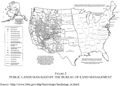
Notice the absence of BLM land in Texas as compared to New Mexico, for example.
Since 1934, various political constituencies, ranging from ranchers to mining companies to conservation and recreation groups, have competed to influence agency policy over access and use of the public domain. Private grazing leases that had been transferable with ranch properties became more insecure as limits were placed on them and as lands were dedicated to other uses. The resulting tenure uncertainty affected grazing practices, investments, and rangeland values.80
Libecap, Locking up the Range, pp. 65–102.
Currently, the BLM administers some 177,053,843 acres of range land in the continental United States (see Table 2), almost a quarter of the acreage in 11 western states, including nearly 70 percent of Nevada, over 40 percent of Utah, and over 20 percent of Wyoming, Oregon, and Idaho.81
Libecap, Locking up the Range, p. 2. See also Public Lands Statistics, fiscal year 1998 for range land totals in the United States and Alaska, and fiscal year 1996, table 1-3 for more detailed breakdowns of federal land ownership by state, including that administered by the USDA Forest Service, and Department of Interior, National Park Service, http://www.blm.gov/natacq/pls98/98PL1-4.PDF.
Rangelands of valuable heritage and character are another matter and have been placed in National Parks and Monuments.

FIGURE 2 PUBLIC LANDS MANAGED BY THE BUREAU OF LAND MANAGEMENT
FARM LAND
Unlike miners and ranchers, homesteaders could claim federal land using existing land policy. Individual ownership of a single plot of farm land was allocated under the Homestead Act and similar land laws through a combination of first-possession and uniform allocation. When setters found sites, they had to rush to file a “homestead entry” for 160 acres at the local General Land Office before it was claimed by others. There were beneficial use requirements so that each entry had to be occupied and improved for three to five years before title could be obtained from the General Land Office. Abandoned claims were open to new entry. One hundred sixty acre distributions that had worked well in the Midwest were applied in the West.83
Allen, “Homesteading,” argues that the Homestead Act in the West was designed to promote dense settlement in order to reduce federal enforcement costs in Indian conflicts over land.
Individuals were not to file homestead entries for sale to others. Applicants for title from the General Land Office were to swear that they: “did not apply to purchase the same on speculation, but in good faith to appropriate it to his own exclusive use and benefit; and that he has not directly or indirectly, made any agreement or contract, with any person or persons whomsoever, by which title he might acquire from the Government … should inure” to others.84
Quoted from Henry Copp, Public Land Laws, in Libecap and Johnson, “Property Rights,” p. 131.
Hansen and Libecap, “Allocation,” pp. 125–26, discuss homestead consolidation and the greater change in farm size between 1920 and 1982 in the Great Plains, where homesteads were too small relative to the Midwest, where small farms were more viable and New South Wales in Australia, where larger initial claims were possible.
The Great Plains and Far West were semi-arid, with annual rainfall of 20 inches or (much) less and erratic distribution.86
Webb, Great Plains, p. 17; and Libecap and Hansen, “Rain,” p. 92.
Because homesteaders did not understand the climate and the eventual need for larger farms, they typically did not seek larger allocations nor did they lobby for major changes in the land laws.87
There were cases where Homestead claimants fraudulently involved family members and others to make multiple entries. But this practice was not widespread given observed distribution of farm size in the northern Great Plains where 160 acre units were most common. See Hansen and Libecap, “Allocation,” tables 2 and 3.
Libecap and Hansen, “Rain.”
One consequence of these small-farm allocations was extensive farm failure.89
In general, early farm settlement was more successful in the Midwest. See Ferrie, “Wealth Accumulation”; and Stewart, “Migration,” for discussion of the benefits of the capital gains in land values as a source of wealth accumulation.
Libecap and Hansen, “Rain,” p. 104.
Hansen and Libecap analyze the effect of drought on small homestead farms in three eastern Montana counties, Cascade, Carbon, and Fergus, using county directories, dating from 1916 through 1930.91
Hansen and Libecap, “Allocation,” p. 115.
Hansen and Libecap, “Allocation,” p. 117.
Small, Great Plains farms not only were less likely to survive drought, but they were more vulnerable to commodity price fluctuations. Lee Alston shows that, across the country, mortgage debt and foreclosure rates were highest and average earnings were lowest on the northern Great Plains during the fall in commodity prices in 1921–1940.93
Alston, “Farm Foreclosures,” pp. 888–95.
The adjustment process toward larger farm sizes, however, took time. Over 60 years of farm consolidation was necessary to achieve more optimally sized farms on the Great Plains. Meanwhile, there was dramatic out-migration. The population of many of the 363 Great Plains counties peaked in 1910 and two-thirds had their largest populations in 1930 or earlier.94
Hansen and Libecap, “Allocation,” pp. 125–28.
A second consequence of small farm allocations was overcultivation and lack of investment in erosion control that had serious environmental effects with the Dust Bowl of the 1930s. The Dust Bowl was a classic common-pool problem. Small homestead farmers cultivated more of their land to meet income targets, leaving it exposed to damaging wind erosion. They were less likely to adopt strip-fallowing practices that could slow the flow of wind. Their farms were too small to internalize the benefits of downwind erosion control, and they bore high opportunity costs because strip fallow required between a third and a half of a farm to be left idle, a cost they could not bear. The large number of homesteaders also raised the costs of collective action to privately organize to combat erosion. Small farms were checker boarded across the land, surrounding somewhat larger farms, a condition that increased the potential for externalities from those farms that failed to practice erosion control.
To effectively address erosion, all of the cultivated acreage in an area of 50,000 to 500,000 acres or more would have to be “treated” with windbreaks and strip fallow. Even optimal farm sizes for production, estimated at 1,280 acres at the early 1930s, were too small.95
Hansen and Libecap, “Small Farms,” p. 672.
Hansen and Libecap, “Small Farms,” pp. 679–80.
Gutmann and Cunfer, “New Look,” provide another thorough examination of the origins of the Dust Bowl and place more emphasis on temperature.
Hansen and Libecap also found that counties with less fallowing (higher cultivation shares of total farmland) had more serious erosion, controlling for other natural factors.98
Hansen and Libecap, “Small Farms,” p. 682.
TIMBERLAND
In the East where there were large tracts of timberland, such as in the Great Lakes states, there were unrestricted cash and script [scrip?— sales of land by the Federal Government.99
For discussion of harvest practices on Great Lakes timberlands, see Johnson and Libecap, “Efficient Markets.”
27 Stat. 348; Gates, History, pp. 485–93, discusses the law and its use.
To assemble enough forest land, lumber company officials negotiated with land agents who hired entrymen to occupy and “farm” the land until title could be obtained from the General Land Office. Once title was received, it was transferred to the land agent, who in turn sold the property to the timber company for a prenegotiated price, usually $6 to $7 per acre.101
Libecap and Johnson, “Property Rights,” pp. 135–36.
Libecap and Johnson, “Property Rights,” pp. 136–38.
Libecap and Johnson conjecture that if this case were typical and the same process were used to acquire the 4,000,000 acres of federal timberland transferred through the Timber and Stone and Preemption Acts at the six major land offices in the Pacific Northwest between 1881 and 1907, then fraud may have increased land acquisition costs by an additional $17 million and thereby delayed titling by up to six years.103
Libecap and Johnson, “Property Rights,” pp. 137–38.
See Johnson and Libecap, “Efficient Markets,” for examination of the claims of conservationists regarding the harvest of timber.
The Public Lands Commission of 1879 investigated the problem facing both ranchers and lumber companies in the West. In 1880 the Commission issued its report to Congress, calling for the reclassification and sale of the varied western lands according to their best uses, including the use of 2,560 acre individual allotments.105
U.S. House of Representatives, Report, pp. ix, xix, xxiii. See also Donaldson, Public Domain, pp. 541–42.
26 Stat.1096-97. Gates, History, pp. 399–400; and Libecap, “Political Economy,” p. 272. The Forest Reserves were transferred from the Department of the Interior to the Department of Agriculture in 1906.
The law authorized the President “to set apart and reserve, in any State or Territory having public land bearing forests, in [sic— any part of the public lands wholly or in part covered with timber or undergrowth, whether of commercial value or not, as public reservations.”107
Quoted in Gates, History, pp. 565–66.
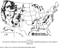
Gates, History, p. 580; and U.S. Forest Service, http://www.fs.fed.us/aboutus/.
See for example, Sedjo, Vision.

FIGURE 3 NATIONAL FORESTS AND GRAZING LANDS ADMINISTERED BY THE FOREST SERVICE
SURFACE WATER
In the Far West, surface water is allocated through first-possession under the appropriative rights system. This arrangement allows individuals to claim, move, and use water based on priority of claim.110
Burness and Quirk, “Appropriative Water Rights.” See also Dunbar, Forging New Rights and “Adaptability”; Kanazawa, “Efficiency”; and Morriss, “Lessons,” pp. 865, 867–91.
Under the appropriative rights system, individuals were granted usufructory or possessory rights to water, rather than fee simple title.111
Getches, Water Law, p. 83.
Wyoming Rules and Regulations, State Engineer, Ch1, Sec 4. Water is property of the state. WY ST 41-3-101 says that individuals can have rights for beneficial use and they can be sold with the land or detached from the land.
There were no restraints on transfer so long as no harm was inflicted on other diverters, who sequentially used some of the same water. An upstream farmer who diverted water for irrigation consumed only part of it, with the remainder percolating through the ground back to aquifers, streams, or to ditches for repeated access by other downstream parties. Small water exchanges among miners or farmers within a watershed were therefore unlikely to have much impact on others. But larger trades that involved changes in the location, timing, or nature of use, were likely to have some external effects on others. Removal of significant amounts of water out of a watershed reduced downstream flows and therefore decreased the water available for lower-priority claimants. As a result, all western states have regulated such transfers. To mitigate adverse third-party effects, state water agencies typically allowed changes in diversion and location for only historical consumptive uses.113
Anderson and Johnson, “Problem”; and Johnson, Gisser, and Warner, “Definition,” describe how specifying a property right in water in terms of consumptive use with options for third party grievances can be an effective method for promoting transfers.
The appropriative rights system is quite different from that which exists in the eastern U.S., where surface water rights are based on riparian land ownership.114
Morriss, “Lessons,” p. 868. Rose, “Energy,” discusses the evolution of property rights and experimentation with riparian rights.
Getches, Water Law, p. 33.
In the semi-arid Far West, however, where there is a general absence of water and what exists is irregularly located, there was a need for institutional innovation that would allow water to be claimed and transferred to settlement locations, often out of the watershed. For example, prospectors who located ore in remote mountain sites required more water for placer and hydraulic mining techniques than was available locally. Similarly, those farmers whose properties were not near major water sources required additional irrigation water to increase farm yields and to smooth them during drought.
Western semi-arid conditions meant that water would have to be brought via aqueducts, ditches, or canals to the locations remote from the point of diversion. And for this to occur, the system of water rights had to be modified from the riparian system. Appropriative property rights were developed through local contracting unencumbered by outside constraints, in much the same way as western mineral rights or livestock associations were formed.116
Glennon, Water Follies, pp. 14–21; and Getches, Water Law, pp. 74–189. Kanazawa, “Extralegal Origins,” points out that every mining district that was exclusively “dry” adopted first possession, and every district that was exclusively “wet” did not. Anderson and Snyder, Water Markets, pp. 37–44, provide a summary of irrigation institutions that developed to transport and allocate water for agriculture.
These local rules were recognized subsequently by the states. The most arid western states—Arizona, Colorado, Idaho, Montana, Nevada, New Mexico, Utah, and Wyoming—constitutionally or statutorily adopted the appropriative system.117
Getches, Water Law, p. 81.
Getches, Water Law, p. 8.
At the time of the development of the appropriative rights system, there were single, homogeneous constituencies in each area—miners in mining camps and farmers who typically were members of ditch companies or irrigation districts. They had similar interests in the diversion of water from streams to support economic development in mining and farming. This condition allowed for the smooth development of the appropriative rights system.
Appropriative water rights have supported the development of mining and agriculture in the semi-arid West. They provided security for investment in mining and agricultural water infrastructure, including elaborate irrigation networks provided by mutual ditch companies, irrigation districts, and the Reclamation Service (later, the Bureau of Reclamation) to promote the region's flourishing agriculture.119
The Reclamation Service was established by the 1902 Reclamation Act, 32 Stat. Pt. 1, 388. It became the largest single water supply organization in the country. See Gates, History, pp. 654–59; and Pisani, From the Family Farm.
The prior appropriation system also formed the basis for moving water from one location to another to provide for urban water supplies. Most dramatically, Los Angeles acquired the appropriative water rights held by Owens Valley farmers between 1905 and 1935 and constructed the 250-mile Los Angeles Aqueduct between 1907 and 1912. The aqueduct cost $25,000,000; was an engineering marvel; and made the growth of Los Angeles as the largest metropolitan area in the West possible, providing as much as 80 percent of the city's water supply.120
It is now around 34 percent following a variety of environmental court cases. See Libecap, “Chinatown: Owens Valley and Los Angeles” and Owens Valley Revisited, chapter 8.
See Glennon, Ker, and Libecap, Western Water Data Set.
CONCLUSION
On-going efforts to mitigate the losses of the commons in various environmental and natural resource settings have brought renewed consideration of the use of property rights arrangements. These include individual transferable quotas (ITQs) in fisheries, tradable emission permits in air pollution control, and exchangeable development permits in land use planning. While attractive because of their ability to better link private and social net benefits in decision making than is possible with traditional command-and-control regulation, property rights instruments face complicated institutional design and implementation problems.
For example, disputes over the types and distribution of ITQs to be granted in U.S. fisheries resulted in a four year moratorium on their expansion in 1996.122
Sustainable Fisheries Act, 16 USC 1801.
Arnason, “Review,” pp. 12, 52–57; and Leal, Evolving Property Rights.
Doyle, Singh, and Weninger, “Fisheries Management.”
These actions are quite similar to the constraints placed on homestead allocations and the rejection of the larger land claims of ranchers and timber companies. The experience on the western U.S. frontier helps to explain the political support for such restrictions, but also suggests that they may have unanticipated long-term consequences and weaken the ability of the ITQs to conserve the fishery stock and provide sustained financial benefits to fishers.
Overall, the development of property rights to natural resources in the western U.S. in the nineteenth century provides a number of conclusions about the design and allocation of property rights. One is that first-possession or recognition of existing resource-use practices and allowing local conditions to determine production size is likely to be the most effective allocative mechanism. Its empirical regularity on the frontier suggests that first-possession has had important efficiency attributes. The most successful allocations, mineral rights, membership in livestock associations, and appropriative water rights were all determined locally.
Outside government constraints on who could obtain property rights and mandates for uniform (small) allocations to meet distributional objectives had negative results for timber, range, and farm land. Small homesteads failed, stranding farm investments and necessitating out-migration. In their desperation to earn an income on farms that were too small, homesteaders overcultivated and underinvested in erosion control, with serious environmental effects. Ranchers and timber companies could not obtain title to sufficient range and timberland. By default much of the current federal holdings of 391,340,229 acres in the continental United States (21 percent of the total area) were left to long-term political and bureaucratic management as the “public lands.” Allocations and uses of those lands have shifted as the political influence of various interest groups has waxed and waned.125
Fiscal Year 1996 Public Lands Statistics, http://www.blm.gov/natacq/pls98/98PL1-3.PDF, continental states only.
A second conclusion drawn from the far western frontier is how long property rights allocations endure, even in the face of accumulating evidence that some are ex post inappropriate. The private transaction costs of adjustment to new arrangements and the political transaction costs of changing property assignment rules are very high. Hence, there is opposition to change and pressure to maintain the status quo, resulting in path dependencies in property distribution patterns and use. A related, third conclusion is that substantial resource rent dissipation is tolerated because of the distributional implications of changing property-rights allocations. Only late in resource use, after many of the rents have been lost are institutional changes typically enacted, and even then, they will be incrementally and incompletely adopted to mitigate political opposition.
Finally, the experience of property rights on the far western frontier reveals their critical importance in directing resource use, trade, and investment. These benefits were recognized by the region's early settlers who had to devise their own arrangements to meet new conditions and to avoid the potential losses of open access. In the most successful cases they were free to do so and in the other cases they were constrained by formal land policy with less positive long-term results. The rich and compelling economic history of the Far West has evolved around these different institutions and it provides valuable lessons for contemporary efforts to address the Tragedy of the Commons.
Prepared for the Economic History Association Meetings, 14–17 September, Pittsburgh, Pennsylvania. Helpful comments were provided by Lee Alston, Terry Anderson, Bob Deacon, Charlie Kolstad, and Zeynep Hansen. Support for this research was provided by National Science Foundation Grant 0317375, the Hoover Institution, and the Earhart Foundation.