

We already have an extensive literature on the measurement of longitude, one which emphasizes the needs of navigators. This explains the limited precision of the astronomical methods that navigators employed, and the search for improvement. It concludes with the development, towards the end of the eighteenth century, of the marine chronometer as the solution to the longitude problem.Footnote 1 Such an account is, however, a very partial one because it pays little attention to the problem of the determination of longitude on land. That was necessary not only to map coastlines and ports, but also to bring together data from different observatories in a coherent fashion. Until well into the nineteenth century longitude on land was found, as at sea, mainly by astronomical means. The techniques used were somewhat different, and observations of any sort were of course easier in the comparative comfort of an observatory than on the deck of a ship at sea, but the required precision was greater and the difficulties no less apparent.
From the late eighteenth century various new terrestrial techniques were developed.Footnote 2 Some measured the difference in local time at two observatories – which is the same as their difference in longitude – using new and non-astronomical methods for the establishment of simultaneity: these included the observation of exploding rockets from long distances and the carriage of chronometers. An alternative approach was the operation of geodetic surveying, by which distances between observatories were measured using triangulation surveys. Then, in the mid-nineteenth century, the innovation of the electric telegraph offered another method of establishing simultaneity, one to which historians ascribe great importance. Stachurski's Longitude by Wire: Finding North America documents the role of telegraphy in the mapping of North America and its geographical connection to Europe, whilst Galison's chapter ‘The electric worldmap’ gives us a perspective of its global reach.Footnote 3 The Cambridge Concise History of Astronomy goes so far as to claim that the electric telegraph ‘solved the problem of longitude on land’.Footnote 4 That, I will show, is a long way from the truth. One clear example is the difficulty experienced in the measurement of Paris–Greenwich longitude by telegraph: four decades after the first determination of the early 1850s, and after two remeasurements by the finest observers from the world's leading observatories, its value remained subject to uncertainty and dispute. That situation was described at the time as a ‘thorn in the side of European geodesy’, one which was not removed until a fourth measurement in the early 1900s.Footnote 5
The difference in longitude between the observatories of Paris and Greenwich was, until the later nineteenth century, the single most important measurement of this type in the world. The two observatories defined the world's two most important cartographic reference meridians. They also provided data for annual publication in Connaissance des temps and the Nautical Almanac, one or the other of which was a vade mecum for a large proportion of the world's navigators. These books – containing astronomical ephemerides for the determination of longitude, and the actual longitude of many important locations – referred to the meridians of Paris and Greenwich respectively. Both publications relied to an extent, however, on data from the other country's observatory, adjusted for the difference in longitude. So if new data caused Greenwich to ‘move’ relative to Paris, various far-flung parts of the British and French empires would do the same in sympathy. Paris–Greenwich longitude was, therefore, measured more often and with greater emphasis on precision than any other such pairing.Footnote 6
I will use this history of Paris–Greenwich telegraphic longitude as a case study in scientific method: an exercise in precision measurement extending over some fifty years, with improvement based on the mutual grounding of results within a web of measurement.Footnote 7 In part, the mutual grounding was between techniques of measurement that were, in an operationalist sense, fundamentally different. In part, it was between French and British practitioners who worked simultaneously on particular determinations. And in part it was within the growing web of telegraphic longitude measurements between other major observatories. The level of trust in any determination of Paris–Greenwich longitude depended on the extent to which it was in reasonable agreement with results from other operations, with those taken by other observers during the same operation, or with those derived from the web of measurement. Yet when there was no such agreement it was not necessarily clear why. Hence measurement and theory had to be revisited, improved or sometimes abandoned in order to make progress.Footnote 8 This study will show that practices of mutual grounding are not a matter of retrospective historical conceptualization of scientific method; rather they were actively employed by participants on a continual basis.
My study will also emphasize that proper analysis of exactly how improvement occurred needs to look beyond any single innovation to other more gradual change.Footnote 9 Recent scholarship has identified ‘observatory techniques’ as the whole set of physical, methodological and social techniques rooted in the observatory.Footnote 10 I show that improvements in precision were driven by multifaceted improvements in many aspects of observatory technique, including better instrumentation, revised practices of observation, innovations in data recording, refinement of star catalogues and the growth of networking between observatories. These developments were, in many respects, more important in the search for precision in the measurement of longitude than the innovation of the electric telegraph itself.
The first telegraphic linkage
At the end of the eighteenth century, decades of astronomical determination of Paris–Greenwich longitude still left Anglo-French disagreement as to its correct value. This disagreement was the catalyst for a first cross-Channel geodetic triangulation in the 1780s, which produced a result of 9 minutes and 20 seconds, with an uncertainty of a couple of seconds.Footnote 11 A measurement by the astronomer John Herschel followed in the 1820s, employing exploding rockets: by establishing rocket-firing stations and intermediate observing stations, and by firing rockets ‘down the line’, a chronometric bridge was constructed between Greenwich and Paris. Despite manifold practical difficulties, the new result of 9 minutes and 21.6 seconds was considered to be within one-tenth of a second of the truth, as a result of the ‘excellence of the method’, and was formally adopted.Footnote 12 In the years that followed, a technique called a chronometer run conducted by Edward Dent, a renowned manufacturer of chronometers, provided support from a different operation of measurement.Footnote 13 And new computations of lunar data by the French astronomer Bouvard, and a second cross-Channel triangulation, also gave no cause to quibble.Footnote 14
In 1826 John Herschel had asked, in a footnote to the description of his measurement by rocketry, ‘Might not telegraphs be employed to ascertain the difference of longitudes of the stations between which they are established?’Footnote 15 He had optical telegraphs in mind, but it was electric telegraphs that would in due course be used for the purpose. The United States Coast Survey began telegraphic longitude experiments in 1846 and within little more than a decade had completed a huge telegraphic longitude web covering the entire eastern part of the country.Footnote 16 In Europe, telegraphic longitude measurements soon followed.
In Great Britain, George Biddell Airy, the Astronomer Royal, made plans for the Royal Observatory to become the central distributor of time by means of the telegraph.Footnote 17 An integral part of those plans was to connect British and foreign observatories for telegraphic measurements of longitude. In the last few months of 1851 alone Airy enlisted the support of the First Lord of the Admiralty, agreed terms for a connection with the telegraph wires of the South Eastern Railway Company at Lewisham Station, let the contract for laying that underground connection in a ‘stout lead tube’ from Greenwich to Lewisham, and even sought the permission of the Office of Works to dig up Greenwich Park in order to lay his wires.Footnote 18 The Observatory's domestic telegraphic connection was complete by the summer of 1852 and the first determinations of telegraphic longitude were carried out the following year with Cambridge and Edinburgh. A connection was then made from the Observatory to new wires linking London with the start of the submarine lines at Dover; these wires conveniently ran across Blackheath, close to the walls of Greenwich Park. A simple brass switch, mounted in a locked iron box on the park wall, then allowed Airy (who held the key) to interrupt the London–Paris link and connect the Observatory directly to either city.Footnote 19
In France, matters proceeded in parallel. A commission had been established in 1850 to decide on the extension of the French telegraphic network. It had insisted on a line to Dunkirk, the northern extremity of the critically important meridian through Paris, in order to compare Dunkirk's telegraphic longitude with that previously obtained by geodetic and astronomic means. François Arago, director of the Paris Observatory, proposed using this telegraph line together with the new cross-Channel submarine cable to measure Paris–Greenwich longitude, and in order to facilitate this the observatory was connected to the offices of the Administration des télégraphes in Paris.Footnote 20 Matters were delayed by Arago's illness, which turned out to be fatal. Airy therefore pressed ahead instead with a measurement to Brussels, via the submarine cable to Ostend, in 1853. The measurement to Paris came the following year, carried out in cooperation with Urbain le Verrier, the newly appointed director of the Observatory. Le Verrier had been, not coincidentally, secretary to that helpful French commission on telegraphs of a few years before.
The basic principle of the telegraphic determination of longitude is to establish local time simultaneously at two observatories by the detection of the same telegraph signal. It therefore proceeds in two parts. The first is the astronomical calibration of the observatory clocks, based on the long-established practice of observing star transits across the meridian plane with a transit instrument. The second is the timing of a series of telegraph signals at both observatories, by observation of the movement of a galvanic telegraph needle. If a particular signal is observed 9 minutes and 20 seconds later in Greenwich than in Paris by their respective clocks, then that is the difference in longitude. Many precautions were taken for the reduction of error.Footnote 21 The personal equation, the tendency for observations by two people to differ systematically, was eliminated by exchange of observers.Footnote 22 Time at Greenwich and at Paris was measured in two ways: both absolutely, using data on the major stars taken from star catalogues, and relatively, using only stars observed in both places. New types of uncertainty arising from telegraphic techniques, such as the unknown length of time that it took for an electrical impulse to travel across the Channel, were dealt with by sending signals alternately from each station.Footnote 23 And there was improvement in the traditional astronomical part of the measurement operation, such as the techniques for correction of the various types of error (azimuth, collimation and level) affecting the transit instruments.Footnote 24
Practical problems there certainly were: the exercise was frequently disrupted by clouds that impeded astronomic observations, or storms that disturbed electrical ones. The observers used the regular telegraph to communicate, and their messages starkly illustrate the difficulties they faced. On one night, from France to England: ‘we only received 22 signals last night, weak and almost undetectable … check your apparatus and reinforce the batteries’.Footnote 25 On another night, from England to France: ‘no signals received last night … all the lines were affected by rain’.Footnote 26 But they persevered for a total of eighteen days to obtain over 2,500 individual observations. The conclusion from this data was that the difference in longitude was 9 minutes and 20.63 seconds, with most days’ results being within a couple of tenths of a second of that mean. Airy was confident enough to write, in the annual Report to the Board of Visitors of the Greenwich Observatory, that this determination – notwithstanding the fact that it differed by a whole second from the previously trusted value – was probably ‘very accurate’.Footnote 27
How, then, to explain the lack of reasonable agreement with the older value? To do so Le Verrier undertook a review of all the recent measurements of the longitude difference: the two geodetic triangulations, Herschel's rocketry, Dent's chronometer run and Bouvard's method of lunar culminations.Footnote 28 These, he wrote, were all ‘much further from the truth than we might have believed’, and he went on to make criticisms of all of them: the triangulations both had known flaws of technique or completeness, Herschel had failed to publish some important data, Dent had used fewer chronometers than now was customary, and the astronomical technique was structurally imprecise.Footnote 29 More fundamentally, he argued that proper account had not been taken of the personal equation, through which different observers could record results discrepant by ‘a third, a half, even a whole second and more’.Footnote 30 He wrote of Herschel and Dent's results,
we can see that there is no reason to rely on the results to the nearest second or even more. This conclusion is contradictory to the hopes and beliefs of the time. But it is irrefutable, and we can only be astonished that this well-known source of error was not taken into account.
That judgement is not a fair one – especially on Herschel, given that techniques for quantification and elimination of the personal equation were hardly used at Greenwich until well after his time.Footnote 31 But in summary, he concluded, all previous determinations of longitude difference were now suspect, and it was necessary to start again, using the telegraph to build a ‘vast web’ of French and European triangulation networks. If mutual grounding with previous results did not show reasonable agreement, that was because the previous results simply could not be trusted. All those old techniques were asserted to be ‘far surpassed in precision and certainty’ by telegraphic longitude measurement.Footnote 32 In other words, just as Herschel had done with his rocketry, reliance was being placed on the perceived excellence of the method rather than on any analytical reconciliation to previous results.
The new telegraphic value was swiftly adopted by the Nautical Almanac. It was also adopted ‘with confidence’ by Connaissance des temps, though this was no simple task. The publication by now tabulated the coordinates of hundreds of locations across the world with respect to Paris. A new value for Paris–Greenwich longitude required the recalculation of all those longitudes that had been deduced, directly or indirectly, from Greenwich – a task of such complexity that a year's delay resulted.Footnote 33
The need for remeasurement
The telegraph now became the favoured means for the measurement of longitude over long distances. In Europe it allowed experiments of previously impossible scale. An early example was a project for the connection of the triangulations of Russia, Prussia, Belgium, France, England and Ireland in order to measure a vast arc of parallel subtending one-fifth of the Earth's surface. The longitudes of its extremities would be measured by telegraph, thus giving a ‘crucial test’ of the accuracy of the figure of the Earth.Footnote 34 In the execution of this project, it was considered that the existing cross-Channel geodetic linkage was something of a weak link.Footnote 35 So in the early 1860s it was reconstructed, giving a result for Paris–Greenwich longitude which was almost identical to the previous geodetic determination in the 1820s.Footnote 36 And this new determination by what was by now considered a less trustworthy technique received little notice – certainly not enough to call into question the telegraphic value.
The catalyst for the challenge to the first telegraphic Paris–Greenwich longitude value lay elsewhere, through what might be called the geodetic integration of Europe. That project took institutional form with a Prussian proposal of 1861 that the numerous astronomical observatories of Central Europe should be better connected by triangulation. The objective was now much wider than the traditional refinement of a geometric model for the Earth, also extending to the measurement of deviations from that ellipsoidal model and interpreting those anomalies in terms of the physical structure and gravitational field of the Earth. Fifteen countries and states came together and in 1864 a body called the Mitteleuropäischen Gradmessung met for the first time.Footnote 37 The membership of the body, and the web of measurement that its members created, grew rapidly, with the telegraph playing a vital role. A network of nearly a hundred longitude measurements was planned, covering most of Europe, and each observatory was expected to have at least three connections to the astronomsiche-geodätische Netze (web). Some thirty had already been completed by the early 1870s, and the work continued relentlessly.Footnote 38 In one year alone Leipzig, Vienna, Munich, Padua, Strasbourg, Warsaw, Genoa and a few others were linked telegraphically in various combinations, and this pace of activity was quite typical.Footnote 39
The Paris–Greenwich determination of 1854 was perceived to be a weak link in this growing web. That was in part because the observational data had not been published in full, a procedure integral to the establishment of trust in this sort of result. More important, it had been carried out without the benefit of a new device called the ‘chronograph’.Footnote 40 Hitherto, an observer would time a stellar transit through coordination of eye and ear: he watched a stellar transit over the vertical thread markers in the sights of his telescope, whilst listening to the ticking of a clock. For the timing of telegraph signals, he had the no less delicate task of watching a small galvanic needle in order to detect the first moment of its movement, whilst listening to the clock. In both cases, he then had to record the time in writing, and then return swiftly to his next observation. Despite observers being well practised, errors could amount to as much as a quarter of a second.Footnote 41 The new chronograph used a paper-covered drum rotating at a regular speed, or a moving paper tape; on this, electromagnetically activated pens recorded both event and clock-time signals. The observer now only had to strike a key to create a permanent and precise record of an event's time, be it stellar transit or telegraph signal, whilst clock time was recorded automatically second by second. That is not to say that the precise observation and recording of the bright silver point of a star, surrounded by – as one astronomer wrote – ‘little flashing vibrating rays of colour’ as it crossed several spider-web threads in an eyepiece, was other than a highly skilled occupation. But the chronograph offered improved precison, and it gradually came into widespread use.Footnote 42
The meeting of the (now larger and more realistically named) Europäischen Gradmessung of 1871 asked, therefore, that Paris–Greenwich longitude be redetermined. This request was followed by the first evidence that the currently accepted value might actually be wrong. The US Coast Survey was conducting transatlantic longitude measurements using British and French submarine cables. A new cable from Brest (where the French Atlantic cable landed) to England allowed triangulated measurement of Greenwich–Paris, Paris–Brest and Brest–Greenwich longitudes. The resulting new value for Paris–Greenwich longitude was almost exactly 9 minutes and 21 seconds, with a stated uncertainty of only a few hundredths of a second.Footnote 43 This new value was, however, about half a second more than that provided by the telegraphic determination of 1854. So, as the report of the Coast and Geodetic Survey noted drily, ‘it is to be presumed that another determination will be made before long to verify this important datum’.Footnote 44
In addition, no comfort as to the accuracy of the older determination could be found from mutual grounding within the European web of telegraphic measurement, growing rapidly in sophistication as well as scale. In Germany, techniques of least-squares error analysis were now being applied to combine observations, creating what was called a compensation of the longitude network, allowing assessment of the accuracy of individual determinations.Footnote 45 And France now re-emerged from within its national and imperial borders as a leading geodetic practitioner. The French scientific community had been initially sceptical of the work of the Europäischen Gradmessung – there was, ‘perhaps, something too distinctively German’ in the techniques, calculations and apparatus proposed, reported one Académicien.Footnote 46 But all that changed after the disaster of the Franco-Prussian War; now, the view was that France risked geographic isolation within the continent of Europe, and scientific decline, if she stood by whilst neighbouring powers took the project forward.
One aspect of the re-emergence of France was that the role of the Bureau des longitudes in geodetic applications of astronomy was formalized in 1874, with a new military observatory at Montsouris in Paris placed under its control, used for the training of officers.Footnote 47 Amongst the first major projects conducted from Montsouris were measurements of Paris–Bonn and Paris–Berlin longitudes. A major innovation was that the German and French observers would make simultaneous but independent measurements from adjoining pavilions, using their own instruments and methods. This technique was extravagant in its use of human and technical resources, and was subsequently used infrequently; it was, nonetheless, the model for the later Paris–Greenwich determinations. Good agreement of the independent measurements was intended as proof of their accuracy: the widest difference between the German and French results was about two-tenths of a second (soon corrected to about one-tenth) and seems to have passed without comment. Such a difference was a little larger than the typical error in the latest published compensation of European longitudes, but was by no means exceptional – there were certainly other discrepancies of this scale.Footnote 48
Although Greenwich displayed little interest in making cross-Channel measurements, attention being on distant parts of empire, it could not escape being measured anyway. In the summer of 1876, Airy wrote, ‘several German gentlemen … were engaged for many weeks in the … observations necessary for determining the longitudes of Vienna and Berlin, connected also in some measure with Munich and Paris’.Footnote 49 They were not the only ones. Walter Maunder, an astronomer who worked at Greenwich for many years, described the evidence:
The traces of their visits may been seen here and there about the Observatory grounds in flat stones which lie level with the surface, and bear a name and date like gravestones in some country churchyard. They are not, as one might suppose, to mark the burial-places of deceased astronomers, but to record the sites where, on their visits for longitude purposes, different foreign astronomers had set up their transit instruments.Footnote 50
All this activity soon allowed a number of indirect computations of Paris–Greenwich longitude via Bonn, Berlin and Vienna – which were in every case more consistent with the value determined by the Coast Survey of almost exactly 9 minutes and 21 seconds.Footnote 51 Even the Nautical Almanac recognized that there was a problem: it abandoned the 1854 telegraphic value for a higher one in the late 1870s, and then again in the early 1880s, without explaining why.Footnote 52 Remeasurement was therefore essential.
The second and third telegraphic linkages
A formal request for redetermination of Paris–Greenwich longitude was made by the French to the Astronomer Royal in 1887, to be accomplished with ‘all the accuracy attainable by modern methods’.Footnote 53 That meant making two simultaneous measurements, a matter of significant cost, worthy of mention in the financial estimates of the Royal Observatory that year. And skilled observers were allocated to the task. From France they were a Commandant Léon Bassot, later director of the Service géographique de l'Armée, and a Commandant Gilbert Defforges. From Great Britain, they were Herbert Turner, then chief assistant at the Royal Observatory, and his colleague Thomas Lewis, described as an astronomer of the first rank. It was the French pair who had the recent and extensive experience of longitude work, in France and her colonies, and they educated the British in some techniques. As Defforges told them, ‘Longitude, it's a career in itself’.Footnote 54
One of the French portable transit instruments used in 1888 and 1892, made by the instrument-maker Brunner. The British equivalents were from a set of five made by Troughton & Simms for the Transit of Venus expeditions of 1874; one of these continued to be used for time determination at Herstmonceux Observatory (successor to Greenwich) until as late as 1957. Sources: Mémorial du Dépôt général de la guerre XI (1877); and Derek Howse, Greenwich Observatory, vol. 3: The Buildings and Instruments, London: Taylor & Francis, 1975.

The planchette de chronographe (chronograph board) of the type used by French and British observers in 1888 and 1892. The clockwork-powered reel to carry the paper recording tape is seen bottom centre. The various terminals, switches, galvanometers, rheostats and relays are for managing and equalizing the four different types of signal – clock, transit, ‘signal sent’ and ‘signal received’ – in the manner described in Mémorial du Dépôt général de la guerre XI (1877).
The four observers were each provided with a portable transit instrument and a chronograph of well-proven French design (illustrated in Figures 1 and 2).Footnote 55 The transit instruments were mounted on heavy cast-iron stands, bolted to pairs of stone pillars in each of the observatory forecourts at Greenwich and Montsouris. Laborious observational work was required to establish a number of instrumental constants such as the spacing of the vertical wires used to time meridian crossings and the calibration of micrometer scales. There were eighteen successful nights of observation, spread over two months. The observers were interchanged twice between England and France, to eliminate any change in their personal equations over the course of the work. On a full night each observer recorded about forty star transits, and exchanged sets of signals across the Channel in a carefully choreographed sequence. All possible care was taken to measure and compensate for the collimation, level and azimuth errors of the telescopes; for example, two independent techniques were now used to detect level error, one based on a form of sprit level and another on so-called nadir observations taken vertically downwards off the reflecting surface of a bath of mercury. Every one of these had to be laboriously verified daily. And the critical astronomical time determinations from the transit instruments were double-checked using the observatory transit circle.Footnote 56 Yet when the English and French separately worked up their results, their conclusions differed. Turner wrote,
A preliminary discussion of the observations of the English and French observers … showed a considerable difference – about 0.4 seconds – between their results for longitude. Such a large quantity as this was at first attributed to some mistake in computation, and all the figures were subjected to a careful scrutiny. But although one or two small matters were noticed which would diminish the difference … no serious mistake was discovered.Footnote 57
Documentation from Greenwich shows a number of stages of detective work. First, a handwritten note records that when the discrepancy was first noticed all the remarks in the observers’ notebooks were copied into a single ledger, ‘in the hope of finding something of importance – No result’.Footnote 58 Eventually a discrepancy was identified between some time determinations made by the French and British observers at Greenwich, but it was not possible to say which was in error. Further experimental work, and a visit by Defforges to Greenwich with the French computations, failed to resolve the problem.Footnote 59
There followed, in print, a serious argument.Footnote 60 Turner published the British results in preliminary form; he suggested that the French had fallen victim to some inexplicable instrumental error, in that there was an inconsistency in the level measurements of their transit instruments as determined by the two techniques. If properly adjusted, he claimed, the French result would agree with the British one. A robust rebuttal by the French officers followed. They, instead, suggested that the problem might be a change in the personal equation of one the English observers. Turner replied, thanking the French for their ‘frankness’, but sticking to his guns. What is clear from the exchanges is that, given the volume of data and the complexity of its interpretation, certainty was impossible. The debate moved beyond objective analysis, because issues of professional competence and national pride were at stake. Suspicion fell everywhere – onto delays in electrical relays, onto inconsistent going rates of clocks and even onto the technique itself. Perhaps, as the French observers wrote, ‘the precision that we are used to attributing to telegraphic longitude isn't real’.Footnote 61 So we see another possible outcome of mutual grounding: conflict incapable of resolution, perhaps best described in the French language as an échec.
There was no alternative but to repeat the work with, as Airy put it, ‘special precautions suggested from the experience gained’.Footnote 62 The opportunity to repeat the measurement came soon, in 1892, because in that year a longitude determination between Greenwich and Montreal was planned and some of the necessary apparatus would be in place. A number of changes and improvements were made as a result of the previous failure. For example, difficulties with the going rate of the clock in Paris were addressed by putting it in a basement of constant temperature. And the English now used an improved form of chronograph. This employed a single pen to record both clock and event signals, thus avoiding the difficulty of what was known as pen parallax when two pens were employed.Footnote 63 Unfortunately, both English and French results were almost identical to the values they had respectively obtained four years before.Footnote 64 So no one was any further forward.
The well-travelled Defforges was again summoned to Greenwich to try and identify the source of the discrepancy. One suggestion was that of abnormal differences in the gravitational vertical, or abnormal optical refractions, at the observing stations upon which the transit instruments had been mounted. These were two pillars in the front court, some twenty feet east and west of each other. But new observations revealed nothing. In a further attempt to identify the problem some years later, and using the same equipment, a quite extraordinary experiment was carried out. An astronomical measurement was made of the distance between the two pillars, a difference in longitude of some two hundredths of a second. But this too revealed no anomaly.Footnote 65 In 1899, a full decade after the first measurement, the observations were still being re-examined for error preparatory to their publication.Footnote 66 Despite all these efforts the échec remained. Two of the world's leading observatories had now failed – twice – in the use of a measurement process that was in common and successful use elsewhere. A contemporary American report, after all, could refer to telegraphic longitude determinations as having been ‘so systematized and perfected in the last 15 years that but little remains to be desired’.Footnote 67
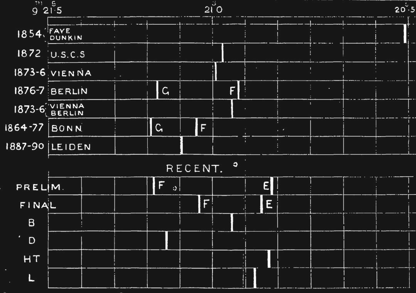
Whilst it is plain that the French and British observers did not reach agreement in 1888 and 1892, it is valid for us to speculate why. This was not because their individual results were implausible in themselves, or differed unreasonably from each other, as the chart in Figure 3, prepared by Turner in 1891, shows.
Chart of Paris–Greenwich longitude determinations, from H. Turner, ‘Note on the recent determination of the longitude of Paris’, Monthly Notices of the Royal Astronomical Society (1891) 51, pp. 155–163, 156. The upper chart is of historic direct and indirect measurements (Faye and Dunkin were the observers in 1854, USCS refers to United States Coast Survey, and ‘G’ and ‘F’ refer to German and French determinations). The lower chart is the result of the 1888 measurement (‘F’ and ‘E’ refer to French and English determinations; ‘B’, ‘D’, ‘HT’ and ‘L’ refer to results from the two French and two English observers respectively).
The final French and English results straddle the expected value of around 9 minutes and 21 seconds. And their divergence of about two-tenths of a second is not far out of line with that deduced from French and German determinations via Berlin and Bonn, where similar discrepancies had passed without comment. In any event, adjustments of the odd tenth of a second were part and parcel of these complicated measurements and computations.Footnote 68 No doubt the French and English practitioners had hoped for better; but a historian has to conclude that disagreement was not just a matter of the size of the difference between their results. It was in large part a function of the fact that any explanation of that difference remained speculative, and had come to reflect badly on the competence of one team or the other. We can understand how much this mattered from the context of that other, recent, astronomical failure of the period, the Transit of Venus enterprise of 1874. That wholly inconclusive exercise has been described by Jessica Ratcliff as an outstanding counterpoint to the many success stories of nineteenth-century metrology, one in which ‘the limits of the Greenwich mastery of instrumental, human, theoretical and analytic systems of measurement were exposed’.Footnote 69
The fourth telegraphic linkage
Whilst in a narrow sense the failure to arrive at an agreed value for Paris–Greenwich longitude was an Anglo-French issue, incoherence with the ever-growing global web of longitude measurement was an increasingly pressing problem. By the 1890s the Europäischen Gradmessung had expanded to be the Internationale Erdmessung (or Association géodésique internationale), with nineteen countries, including the United States and Great Britain, as members. The American delegate to its 1898 conference wrote that the Paris–Greenwich connection had been a ‘sort of thorn in the side of European geodesy for ten years’.Footnote 70 The German geodesist Theodor Albrecht presented a conference paper on the unsatisfactory state of affairs. There followed a resolution requesting a remeasurement, also asking that the 1888 and 1892 observations be published in extenso.Footnote 71 Given that there seemed to be a systematic difference between the English and French results, there was still hope that some independent person might, at last, be able to track down the source of the discrepancy.
There was no British enthusiasm to undertake the telegraphic determination for a third time in recent years, and a letter from the British delegate to Sir William Christie (Airy's successor as Astronomer Royal) gave him the unwelcome news from the conference. He expressed the rather gloomy view that ‘I cannot but hope that it may be possible to find the source of the discrepancy without re-observation’.Footnote 72 But Christie had no choice. The conference had also discussed the possibility that if Greenwich and Paris would not undertake the work, it should be done by foreign astronomers instead – an idea abhorrent to the French. So the Council of the Paris Observatory swiftly met and approved the project, making clear that foreign involvement would present ‘serious inconveniences’.Footnote 73 And another reason for the enthusiasm of the Paris Observatory was that, some quarter of a century before, they had effectively ceded the business of longitude measurement to the Service géographique de l'Armée – this remeasurement allowed them both to recapture it and to show that they could succeed where the Service géographique had so singularly failed. Within a couple of months Maurice Loewy (the then director of the Paris Observatory) and Christie had agreed to proceed, and Loewy moved to get some crédits spéciaux to pay for it.Footnote 74 The Paris–Greenwich measurement eventually went ahead in 1902.Footnote 75
Given the high stakes, every possible precaution was taken to ensure accuracy. Loewy's first letter to Christie on the substance of the project set the scene:
If we are to undertake a third evaluation … we must have every possible guarantee of precision. It follows that to arrive at a result which we are seeking with almost absolute certainty, we will need to verify – beforehand and in a most rigorous way – the instruments, the observers, their methods of operation and of calculationFootnote 76
As before, a skilled team was assembled. From the Greenwich side were Frank Dyson, later to become Astronomer Royal, and Henry Hollis, a veteran of the 1892 determination and an acknowledged expert on transit instruments.Footnote 77 From the Paris side were what the Observatory called ‘two of its best observers’: Guillaume Bigourdan, a renowned and prize-winning astronomer, and Henri Renan.Footnote 78 There was a whole series of improvements in technique.Footnote 79 Amongst them were the use of four identical British transit instruments, recently overhauled by Troughton & Simms; the making of two entirely separate sets of determinations, in spring and autumn, each comprising three series of observations and involving a double interchange of instruments and observers; the utilization again of two techniques for the detection of level error, but now three for collimation error.Footnote 80 And the determination of personal equation was not only by exchanges of observers but also by direct measurement. In addition, astronomical time determination had advanced significantly since the 1850s. Instead of the comparatively few major stars for which reliable data was then available, nearly three hundred stars were now used, their positions deduced not only from European tables, but also from important new American work.Footnote 81 And the whole procedure was carefully choreographed, in a manner governed by a written convention between the two observatories.Footnote 82
To add to the pressure, the popular press now took an interest. In England, the Daily Express dramatically argued that the small uncertainty in Paris–Greenwich longitude was amplified to one of many miles in far-distant countries, risking border disputes over valuable mining properties. A headline – ‘Mistake of 16-100ths – corrected, it may mean the world's peace’ – and an article claiming that it was within the power of astronomers to create ‘a perfect nest of West African crises’ set the scene.Footnote 83 In France, concerns were different. In part, there was the matter of allocating blame: as the daily La Presse wrote, ‘Now we'll see who was wrong’.Footnote 84 And in part, the actual value of Paris–Greenwich longitude had become much more visible as a result of the recent adoption of time zones throughout much of Europe. France was one of the last countries to fall into line, and the contemporary debate was over a proposal to adopt Greenwich Mean Time – possibly expressed, in a less objectionable way, as mean time at the Paris Observatory retarded by 9 minutes and 21 seconds.Footnote 85 The adoption of what was referred to as l'heure anglaise was highly controversial, and perceived by many as damaging to the scientific status of France. Overall, therefore, this was not a background against which failure could be comfortably contemplated by anyone.
For all the precautions taken, matters got off to tricky start. Christie and Loewy were still arguing about procedures for interchange of observers even after the work had commenced.Footnote 86 Then one of the French observers fell ill and had to be replaced. But success was quickly, indeed prematurely, proclaimed. The British results for the spring series of observations were ready first; Loewy called them ‘very satisfactory’, even though the French reductions were still being computed, and asserted that the autumn observation would be even better.Footnote 87 It actually took until 1904 before all the results were ready, in part because another problem had arisen: one French observer found a temperature-related instrument error, which took a year of recalibration to eliminate.Footnote 88 And these results were far from perfect. On the English side, there was a systematic difference between the spring and autumn determinations of nearly one-tenth of a second. In private, Christie admitted that the later observations were ‘decidedly smaller’ than the earlier ones.Footnote 89 Helpfully, on the French side, the spring and autumn results would be more consistent. Less helpfully, one of the three series making up the autumn result was ‘noticeably bigger’ than the others, by well over one-tenth of a second.Footnote 90 Yet the participants made the best of it. When Loewy first compared the results he wrote to Christie, ‘In summary, your longitude only differs from ours … by 0.03 seconds, an entirely satisfactory agreement, and one which would have been absolute if we hadn't taken into account our single doubtful value’.Footnote 91 This was putting the best possible spin on the data. Loewy had chosen an unweighted mean of the British values, not the weighted version later published. His suggested exclusion of an outlier owed more to the practices of the eighteenth century than to those of the twentieth century in the accepted methodologies of combination of observations, and he justified it only on the speculative basis that there must have been a temporary alteration in the observers’ personal equations. But Loewy was unequivocally asserting that there was now agreement on the value of Paris–Greenwich longitude, and the data was just about good enough to back this up. When the final verifications had been made for publication in France some years later the difference between the French and English determinations had actually doubled, to about six-hundredths of a second, but by then no one would quibble. It was still said to be a ‘satisfactory accord’, with the difference easily explained by the probable errors in the two determinations – a statement manifestly unjustified by the statistically derived probable error, which was much smaller.Footnote 92
The Paris–Greenwich determination of 1902 shows, I argue, the highly contingent nature of reasonable agreement. The data for 1902 was less clearly flawed than that from the previous ‘failures’, but it was far from perfect. But in some ways this assisted in the process of finding agreement. One result of the unexplained difference between the English data for spring and autumn was to allow some recalibration of what reasonable agreement should be; this was evidence that the precision historically attributed to telegraphic longitude measurement was not real and that there were types of error as yet not understood. A second was that the imperfections in the data were susceptible to various non-confrontational interpretations. That allowed practitioners who wanted to see agreement, indeed who were under pressure to find agreement, to use the data in a way which proved agreement. It could under different circumstances, and without any great difficulty, have been used to argue the opposite. That is certainly how the one (and only) expert historian to have passed comment on the results saw it. The account by Edmond Guyot, director of the Neuchâtel observatory, notes that despite all the precautions taken there was still ‘a big difference’ between the French and British results.Footnote 93
There was one final bit of mutual grounding to do. In 1905 the German geodesist Theodor Albrecht brought together nearly two hundred different measurements (including seven historic Paris–Greenwich determinations) in the most extensive yet compensation of European longitudes using statistical techniques.Footnote 94 He was in communication with Christie and, while still completing his calculations, wrote with good news: the difference between the new English measurement and that deduced from his compensation was negligible. The previous uncertainty in Paris–Greenwich longitude was, therefore, ‘happily completely settled’.Footnote 95 Albrecht published a value for Paris–Greenwich of 9 minutes and 20.932 seconds, exactly (and of course quite coincidentally) the same as the final English determination of 1902. Christie could not resist pointing this out in his preface to the publication of the English results, which at last reported the data for the 1888 and 1892 measurements as well. The Nautical Almanac for the year 1909 adopted this new value for Paris–Greenwich longitude, and Connaissance des temps followed a few years later, closing the telegraphic chapter in the story of Greenwich–Paris longitude.
Conclusion
I have described in this article for the first time the history of Paris–Greenwich longitude determination by telegraph. As Martina Schiavon has observed, historians have seldom paid attention to the interaction between the observatory and geodesy, and the same can be said of the interaction between the observatory and the geodetic use of the telegraph.Footnote 96 Such interaction, evidenced in this article, reinforces recent scholarship that emphasizes the observatory's multiple roles in nineteenth-century scientific life. In particular it demonstrates the breadth of the set of ‘observatory techniques’ that were an essential part of precision measurement practice, and the importance of observatories as part of a data-gathering network rather than as stand-alone institutions.
One of my purposes has been to use this history of Paris–Greenwich telegraphic longitude as a case study in precision measurement. The conclusion of the study is that practices of mutual grounding were very much a reality. The first Paris–Greenwich longitude determination by telegraph was grounded against previous determinations by astronomy, rocketry and chronometry; the second, third and fourth measurements by telegraph were all mutually grounded between British and French observers; and mutual grounding also took place between direct Paris–Greenwich longitude measurements and values deduced from the growing web of telegraphic measurement. All of these contributed to improvement over time, but not in any linear way – more in what Thomas Kuhn described as a ‘complex and time-consuming mopping-up operation’.Footnote 97 And the need for that mopping-up was demonstrably driven by failures to reach reasonable agreement in the mutual grounding process. What I have also shown with this case study is how variable, or circumstantially contingent, are the criteria for such agreement. In the first Paris–Greenwich telegraphic longitude determination, a significant difference from all previous measurements was explained away by arguing that those previous measurements were simply wrong. In the second and third determinations, there was a much smaller difference between French and British determinations, unremarkable by the experimental standards of the day. That, nonetheless, became a source of conflict and disagreement between the parties, one that came to be more about national scientific competence than about simple numerical precision. And in the fourth determination, a frankly disappointing agreement between various French and British measurements was, in the context of external pressure to succeed, glossed over to allow that success to be announced.
A second purpose of this history has been to draw attention to the importance of gradually changing techniques, which can be of greater importance than the more visible innovations that often attract the majority of historical attention. Paris–Greenwich measurement by telegraph was initially no more accurate than that by rocketry and chronometry some decades before. Over the next half-century, accuracy improved by an order of magnitude. But the improvements were not, in the main, to do with the telegraph itself. As a basic tool for establishing simultaneity, there was not that much that needed to be done. There was, of course, significant progress in many areas, such as in the electrical field theory and measurement standards that supported telegraphic practice.Footnote 98 But the particular use of the telegraph for longitude measurement was not, in important ways, a demanding one. The retardation effects that troubled early submarine telegraph engineers could be dealt with by measurement, and – unlike the commercial telegraph, where closely spaced but clearly distinct pulses were needed for rapid communication – only single pulses were employed. And whilst telegraphic techniques did become more difficult as distance increased, Paris and Greenwich were not that far apart.
What did change substantially were the techniques for astronomical time determination, which had been evolving over centuries, and the recording of signals. There were the new chronographs, allowing a permanent record of star transits, observatory clock time and telegraph signals; the innovative reversible transit instruments for stellar observation; the ever more sophisticated techniques for eliminating instrumental errors; the increasingly diligent approaches to compensation for the personal equation; and the refinement of star catalogues that were the drivers of improvement, not the telegraph itself. These were observatory techniques, not those of the telegraph engineer. Many of these improvements were equally applicable to other methods of establishing simultaneity. As an example of that, a series of chronometer runs between Paris and Greenwich in 1920 – now facilitated by a rather different innovation, the scheduled London–Paris aeroplane service – produced a result almost identical to the best that telegraphy ever did.Footnote 99
The early years of the twentieth century were the high-water mark of telegraphic longitude measurement. The Paris–Greenwich longitude question had finally been resolved, coincidentally at much the same time as signature of the entente cordiale between France and Britain. Order had been brought to the web of European longitudes, and that web was now firmly and telegraphically attached westward to the Americas and eastwards to Russia and Asia. The missing link was a cable across the Pacific – to allow the crucial test of telegraphic longitude, a measurement the whole way round the world. That cable, linking Manila to San Francisco, was finally laid in 1903 and soon put into use by the US Coast Survey. The longitude of Manila was now known both eastwards via San Francisco to Greenwich and westwards via Madras to Greenwich. The Coast Survey found a closing error of less than one-hundredth of a second, or about nine feet.Footnote 100 Given the number of links in each longitude chain, the different national contributions, the difficult terrain traversed and the sometimes makeshift equipment used, this was compelling evidence of telegraphy's capabilities.
Paris–Greenwich longitude was, however, never again measured using the telegraph; in the early years of the twentieth century wireless telegraphy emerged as the successor technology for precision longitude measurement. The actual value of Paris–Greenwich longitude had, though, greater prominence than ever before. By a decree of 1911 (see Figure 4), France did eventually fall into line with the worldwide system of time zones and adopt l'heure anglaise, though with a twist to preserve amour-propre. She adopted, as legal time, not Greenwich Mean Time itself but Paris Mean Time, retarded by 9 minutes and 21 seconds.
‘Important notice’, being an extract from the frontispiece of the Annuaire of the Bureau de longitudes for 1914. It was printed on red paper as a warning to readers of the change to French legal time and of the new basis for the published astronomical data.
Any damage to French amour-propre was mitigated by the country's lead in the new techniques of wireless time-signal transmission, for which the British had no facility until years later.Footnote 101 From 1911, it was this French simulacrum of Greenwich Mean Time that was transmitted from the aerials of the Eiffel Tower. It was thus freely available throughout Western Europe and across the North Atlantic, assisting navigators by allowing shipboard chronometers to be recalibrated daily. So for many users – even, remarkably, the British Grand Fleet throughout the First World War – what they took to be Greenwich Mean Time was actually deduced from the transit instruments of the Paris Observatory, adjusted by the conventional difference in longitude.Footnote 102
Over the next half-century the iterative search for precision in longitude measurement continued, as a worldwide web of time and longitude was constructed by wireless. This project was driven largely from Paris, which became home to the new Bureau international de l'heure after the First World War.Footnote 103 But Greenwich did play a small role from the very start. The observatory managed to procure a wireless receiver from the Admiralty and, during 1912, started receiving the Eiffel Tower time signals for comparison with what one might call proper Greenwich Mean Time.Footnote 104 It then reported discrepancies to Paris by means of a simple daily postcard. Thus commenced the next chapter in the refinement of that crucial difference in longitude, with observatory techniques embracing the wireless as swiftly they had the telegraph.