

Introduction
Some archaeologists have proposed that cultural cognition is figurative and metaphorical (e.g. Donald Reference Donald, Renfrew and Scarre1998; Ortman Reference Ortman2000; Tilley Reference Tilley1994; Reference Tilley1999). Moreover, such scholars assert that a figurative and metaphorical approach to archaeological analysis of material culture offers insights on the collective identity of social groups during historical periods of migration. This paper argues that considering the use of space is also critical to the study of daily cultural practices because it is a vital dimension of human activity, and societies must navigate their surrounding landscapes, both physical and cultural. Furthermore, cultures both create and perceive their place in the world (Cosgrove Reference Cosgrove1984, 13). Similarly, this paper also argues that the social construction and use of space in traditional societies is a cognitive, figurative and metaphoric process and adopts this perspective in this study.
Through figurative and metaphorical processes of cognition, people map existing landscapes as they conceive of them in their minds, and then impose this structure onto their newly colonized lands. In so doing, this process encodes and constitutes their actions and physical surroundings with specific social meanings and memories. Consequently, analysing the cultural construction of space during the migration of a social group through time and across multiple places offers a means to ascertain the figurative and metaphorical dimensions of their world view. Examining evidence for consistent and repetitive patterning in the distribution and layout of houses and settlements in an archaeological area enables scholars to infer the figurative and metaphoric conceptualizations that embody a cultural landscape. Although migrating people are likely to exhibit certain adaptations to their new environments, their conceptual system might present significant continuities. This article summarizes an effort to examine the nature of cultural continuity in ancient settlements that were established and then abandoned by the Kaushi (a Paiwan group in southern Taiwan) as they migrated and created new cultural landscapes.
Theory and themes
Oral histories and ethnographic studies throughout the world have revealed that human populations frequently move across different landscapes as they engage in the formation of political alliances, participate in trade, arrange marriages, or undertake war. In these contexts, do cultures tend to adapt easily to their new environment, or are they resistant to change? In either case, because material culture is manipulated it manifests processes of both change and resistance to change. The materialization of such events provides archaeology with the challenge and the opportunity to interpret ‘extinct’ cultural systems that were not recorded by ethnographers or other writers.
Metaphorical and cognitive approaches in archaeology (e.g. Donald Reference Donald, Renfrew and Scarre1998; Ortman Reference Ortman2000; Tilley Reference Tilley1994; Reference Tilley1999) suggest that cognition and conceptualization are analogical, figurative and participatory in nature. Although figurative thought is a universal of the human experience, its content varies across cultures. As such, differences in cultural cognition are instigated by different ideological conceptualizations of the world, rather than different neurological mechanisms. Moreover, the experience that is gained from the participation and interaction of people may serve as a mechanism for conceptual analogy.
Thoughts are grounded in mental imagery or mental representations, which begin as conceptual analogies of the immediate, perceptual experiences of participating individuals. Humans produce, transfer and process thought and meaning by mapping structured sets of correspondences across domains of mental imagery. Metaphorical conceptualization is the most common and most important mapping mechanism, and is also image-based, being systematically expressed in daily discourse and in material culture, as well as in other aspects of culture. Metaphors, analogy and participation shape forms of communication and foundations of cultural understanding. This enables one thing to be understood and experienced in terms of another and to be expressed in various forms of cultural behaviour, from everyday speech to the structure of ritual, as well as to the production, form and use of artifacts. Metaphors also structure figurative expressions and encode cultural knowledge, meaning, and even memory in material culture (Donald Reference Donald, Renfrew and Scarre1998, 186–7; Tilley Reference Tilley1999, 16–19). They also serve as a mechanism to filter the acceptance of (or resistance to) newly encountered cultural elements.
Ortman (Reference Ortman2000) argued that potters of Mesa Verde Pueblo Culture conceptualized pottery designs (designs on pottery as a new medium) as the equivalent of textile surfaces; he added that mapping the figurative patterns of textiles onto pottery enabled it (pottery) to be perceived analogically and metaphorically. The linkage of designs on textiles and pottery conveyed metaphorical concepts that essentially defined the Mesa Verde Pueblo world. Pottery and textiles were considered to be complementary parts of a larger conceptual whole. Mental imagery and the conceptual structure of textile designs, which existed in the minds of potters, were mapped onto pottery surfaces as pottery was analogized and metaphorized as textiles. If conceptual metaphors are a common denominator of material culture, a comparison of ancient conceptual systems can be undertaken by analysing material remains and oral histories of related descendant groups. Such analyses promise to shed light on their cultural–historical relationships. The metaphorical, analogical, figurative and participatory imagery that is conveyed by designs on certain categories of material culture (e.g. textiles and pottery) encodes the cultural cognition of ancient societies. The meanings and memories that are materialized in such artifacts preserve the cognitive system of a social group—both during and after periods of movement and migration.
Space is a fundamental feature of cultural and social phenomena. It consists of both abstract and concrete properties of culture, and it is embodied in people's daily life and activities. Because dimensions of space are pervasive in daily cultural practices and processes, space is a central characteristic of all human activities (Huang Reference Huang1995, 1–5; Tilley Reference Tilley1994, 7–20). Space is constructed and experienced at multiple, nested scales, including (but not limited to) households, settlements and landscapes. Space is not only the location where a human group enacts its activities; it is also the outcome of such activities (Cosgrove Reference Cosgrove1984, 13; Tilley Reference Tilley1994, 7–20). The concept of space is not only a ‘place’ that is encountered by a human group, it is also a way that the group perceives, imagines and views the world. Its construction is involved in (and is affected by) both natural geographic and anthropogenic environments. Dimensions of space engage with and influence social relationships, political or economic conditions, cultural customs, systems of classification, cognitive structures, symbolic systems and ideologies. Space shapes how human groups perceive their relationship to such environments, as well as the activities that they engage in within them. Space is simultaneously experienced and constructed by humans as they engage in their activities, including the production and use of material culture.
Many scholars theoretically connect space and its various constituents to cultural meaning, social memory and social or cultural identity. For instance, Preucel and Meskell linked space to history and society, regarding the three of them as being interrelated. They viewed the household as a category that connects social identity with a locale. They also emphasize that cultural memory necessarily oscillates between the physicality of monuments, things, and representations, as well as immaterial practices that locate subjects within a new time–space understanding that fuses the past, present, and future (Preucel & Meskell Reference Preucel, Meskell, Meskell and Preucel2007). Similarly, Giddens (Reference Giddens1984), Gosden (Reference Gosden and Hodder2001), Schama (Reference Schama1995), Tilley (Reference Tilley1994) and others link historical memory to the social and cultural construction of space.
Accordingly, landscape is often aligned with memory (Connerton Reference Connerton1989; Schama Reference Schama1995; Tilley Reference Tilley1994). The ways in which social groups interact with newly encountered landscapes are partly structured by how groups previously interacted with earlier locales (Gosden Reference Gosden and Hodder2001; Tilley Reference Tilley1994, 23). Landscape is a medium for (and an outcome of) current and previous actions (Giddens Reference Giddens1984; Tilley Reference Tilley1994, 23). Collective memory is not only materialized in physical monuments, it is also embodied in acts and rituals (Connerton Reference Connerton1989). Together, the construction of monuments (e.g. mounds) and the rituals that took place at them served to inscribe social memory onto a landscape (Pauketat & Alt Reference Pauketat, Alt, Van Dyke and Alcock2003, 220). The preservation and maintenance of social memory is particularly important in societies when they experience frequent movement or migration events.
In using these theoretical concepts, this paper seeks to frame a methodological as well as an interpretative approach that reveals the means by which people signify themselves and their world through their conceptual relationships with their surrounding environments. As noted earlier, the cultural construction of space is figurative, metaphorical, analogical and participatory in nature. Patterning in the use of space is a material expression of a society's cognitive relationship with nature and such patterning also materializes their collective memory. Therefore, the way that a population interprets and maps onto newly encountered landscapes—as they move from place to place—is filtered by their metaphoric and figurative conceptualization of the world around them.
The construction of households, settlements and cultural landscapes on newly encountered lands is a process that entails the ongoing conceptualization and enactment of metaphors in daily social practice. When humans interact and engage with newly encountered lands they bring with them an existing ‘package’ of meanings and memories that guides their conceptualization of the new locale. The importation of a conceptual world view from their original homeland to a newly encountered landscape enables them better to understand and flourish within it.
The central goal of this study is to interpret the spatial dimensions of a particular social group in Taiwan by presenting a methodological approach for examining its daily practices in different times and at different places during periods of migration. Repetitive patterning in the form and layout of house units at settlements and settlement configuration are a hallmark of the figurative and metaphoric conceptualization that governed how this group maps onto newly encountered landscapes. Moreover, time-transgressive continuities in the conceptual world view of a group may also be inferred by documenting potential consistency in the construction and use of space that are figurative, participatory, metaphoric and analogical.
Mapping lands in different times and at different places: a case study
South Paiwan Kaushi and its settlement patterns
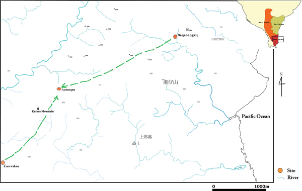
The Paiwan group is one of 16 ethnic groups in Taiwan, and it has been divided and classified into North, South, and East subgroups. Oral histories and ethnographies illustrate that some Paiwan moved from the north to the west and south, and then to the east, where they are currently settled. Kaushi is one of the South Paiwan subgroups. According to oral history, the Kaushi group was further divided into two subgroups when they immigrated to the Hunchun area (Fig. 1). One of these two subgroups settled at Saqacengalj, while the other subgroup moved further along a stream and settled at Cacevakan.Footnote 1 After several generations, the two subgroups merged together and established a third settlement that is known as Aumaqan. According to oral tradition, Saqacengalj existed for 500–600 years after it was initially established. Moreover, 14C dating from Saqacengalj indicates that it was abandoned no later than 350 years ago (Chen Reference Chen2008). However, its precise establishment and duration of its occupation is unknown. The same is true for Cacevakan and Aumaqan.
The South Paiwan Kaushi Study Area and its archaeological sites. (Modified from Chen Reference Chen2010.)
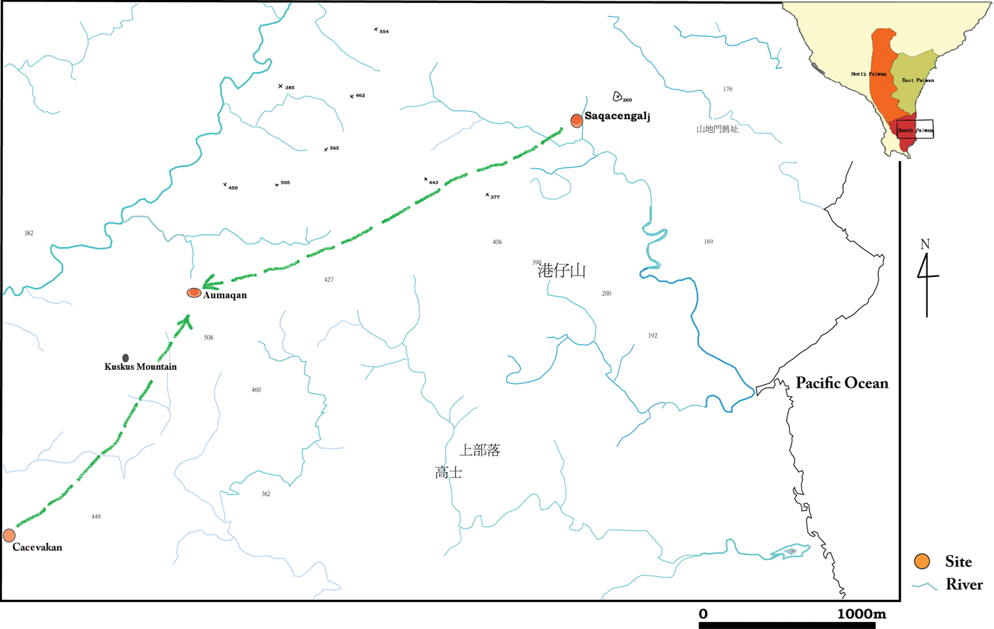
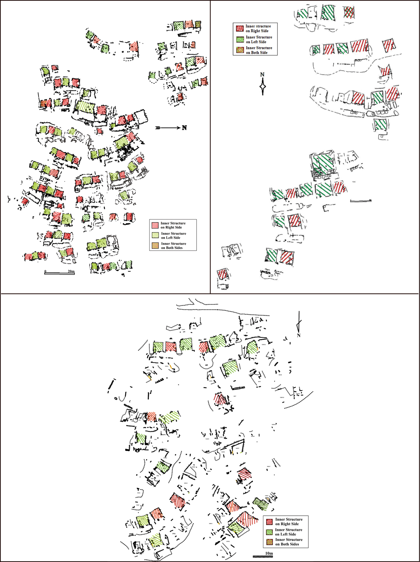
Saqacengalj, which literally means ‘a tool for drilling slates’, is located in the forested uplands in Mudan County, Pintung District, at the southern tip of Taiwan, at 22°09'07”N, 120°51'25”E (see Figure 2). With an elevation of 250–300 m, the settlement was built on a flat slope and it is oriented along an east–west ridge, which is about 170 m from east to west and 130 m from north to south, covering an area of 22,100 sq. m (2.21 ha). It includes more than 14 terraces with more than 107 slate architectural structures.
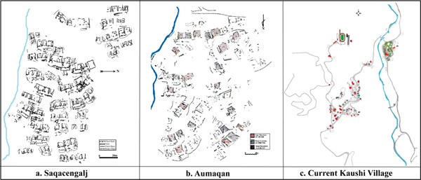
The settlement configurations of Saqacengalj (upper left), Cacevakan (upper right) and Aumaqan (below).
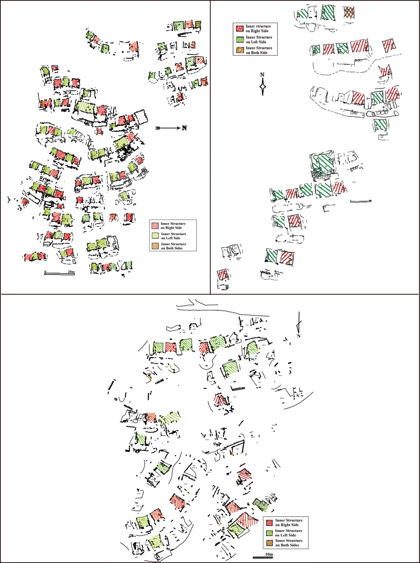
Cacevakan is located on a forested slope facing north at 22°06'16”N, 120°48'11”E, with an elevation of 320–350 m. The number of house structures identified is 32 and they are spread across an area ranging from 140 m from north to south and 95 m from east to west; the area is about 1.33 ha, and consists of 10 terraces. The full extent of the settlement is still unknown because access to the nearby forest is constrained, and a comprehensive investigation of the site cannot be carried out.
Aumaqan is located in an upland area near Chunchai village at 22°07'59.9”N, 120°48'13.49”E, with an elevation of 326–226 m. The settlement is about 140 m south to north and 100 m from east to west. It is on a slope oriented along a north–south ridge with 11 terraces consisting of more than 64 house structures.
The settlement configurations and house structures of these three sites and their surrounding landscapes have been mapped (Fig. 2) and analysed with respect to their spatial characteristics. A major goal of the mapping was to identify and document similarities and differences among the houses and settlements of the Kaushi at different times and in different areas. Such information is necessary for gaining an understanding of the characteristics of spatial construction on Kaushi settlements during periods of migration.
A synthesis of the characteristics of the settlements and architecture at these three sites is offered below (Chen Reference Chen2008; Reference Chen2010; Reference Chen2012).
Broader settlement configuration
With an elevation of 250–350 m, the settlements are on a flat slope that is oriented along an east–west or north–south ridge that includes numeral parallel terraces with slate architectural structures. The slate structures in the main area of the settlement are arranged along the topography facing the valley and against the ridge, and are oriented in parallel rows on each terrace, with the number of structures per terrace varying from 2 to 12; the structures on each terrace are typically adjacent to one another and share a common sidewall (Fig. 2).
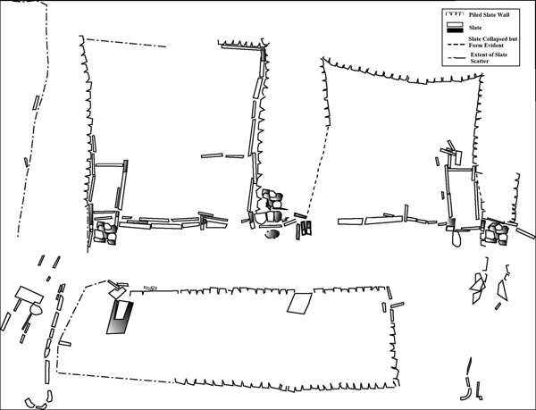
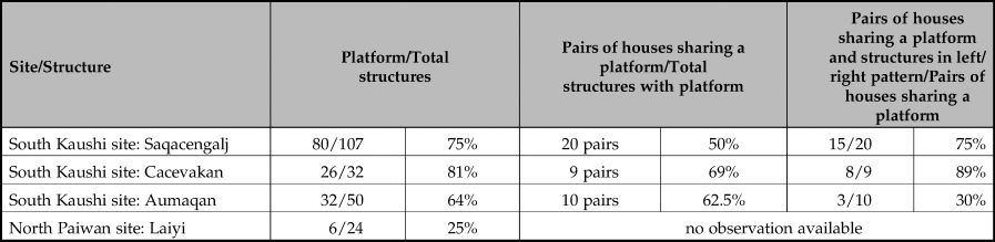
While the slate structures are similar in form, they are quite variable in size, such as in Saqacengalj where they range from 3.89 sq. m to 72.44 sq. m. Besides the house structures per se, there are other kinds of slate features, such as front yard, ditch, platform, and structures attached to platform (see Figure 3). In front of most structural units (i.e. Saqacengalj: 80 out of 107 units, or 75%; Cacevakan: 26 out of 32 units, or 81%; Aumaqan: 32 out of 50 units, or 64%; see Table 1), there is a rectangular platform that varies in size. While some structural units have individual platforms, some of their adjacent structures share a platform that stretches from one end of a unit to the far end of another unit without a clear dividing feature.
Slate structures including front yard, ditch and platform sharing of structures adjacent to each other. (Chen Reference Chen2008, fig. 17.)

Distributions of platforms, pairs of houses that share a platform, and pairs of houses that share a platform with structures in a left/right pattern at the studied sites.

Inner layout of structural units
Typically, slates of varied sizes were piled against the slope of an upper terrace to form the rear wall of a structure unit. The tops of house walls are generally equivalent in height to their respective terrace. By comparing the length and layout of house walls, it was determined that there is a high percentage of house units (i.e. Saqacengalj 81%, Cacevakan 47%, Aumaqan 70%) that are terrace-perpendicular in shape, while the rest of the units are either terrace-parallel or square in their orientation or shape (see Table 2).
Distribution of different house shapes at the studied sites. *Due to poor preservation of the structures on Aumaqan, only 50 units were included in the analysis.

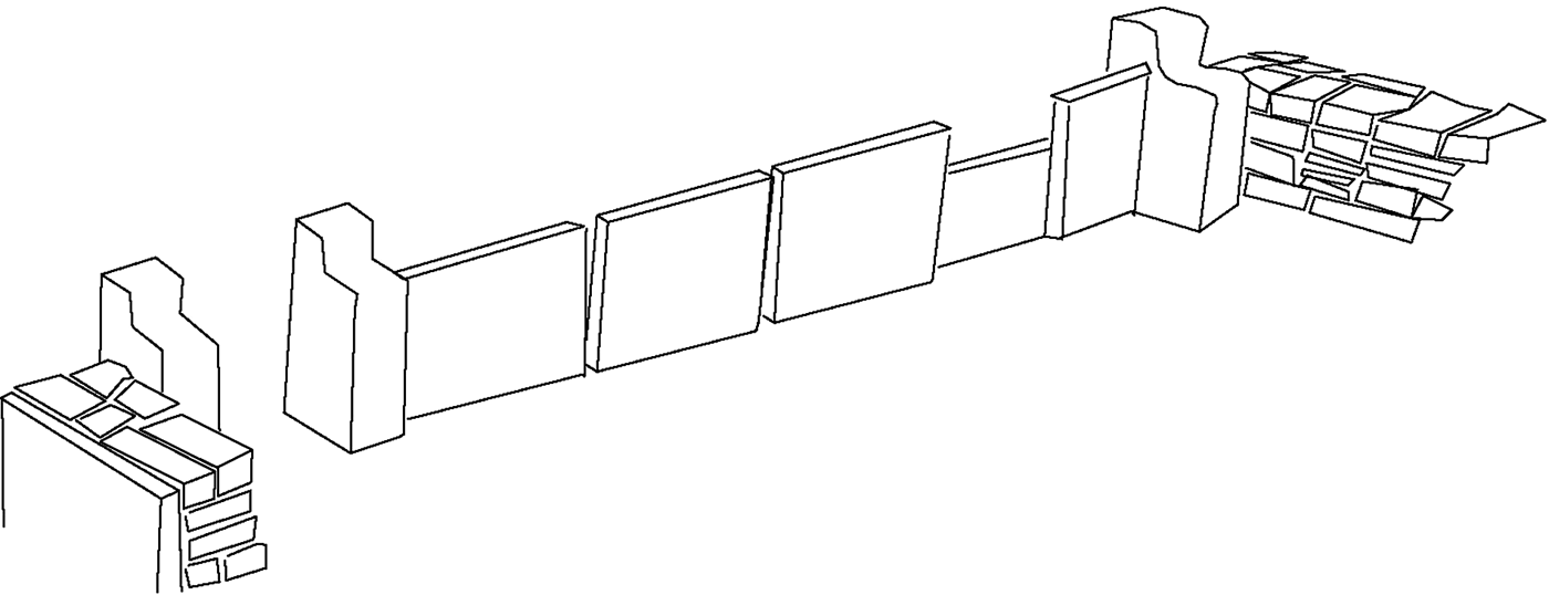
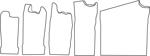
The form and structure of house front walls are typically different from their rear and side walls. Front walls generally comprise several upright flat slates that are conjoined; they are approximately 50–130 cm in width, about 100 cm in height, and 8–10 cm thick. Besides the flat slates, there are three or four pole-like rectangular stones placed between the flat slates, which complete the front wall (see Figure 4). Their stones are 10–20 cm in thickness, 20–30 cm in width, about 100 cm in height, and they have L- or U-shaped tops. The L- or U-shaped top of the stone pole is assumed to have held a wooden crossbeam. There are varied forms of poles that were identified in different positions inside the house units, in addition to those mentioned above (see Figure 5). Given their forms and locations, they were potentially used to support timber construction material (i.e. as crossbeams).
The reconstructed front wall (interior view). (Chen Reference Chen2008, fig. 15.)

Varied forms of stone poles. (Chen Reference Chen2008, fig. 19.)

Synthesizing evidence from all of the house units on the three sites, it appears that there are some small rectangular features formed by purposely erected slates placed in various locations within the units (including the left, right, front, or rear part in the inner portion of units). Two units sharing a side wall and platform have small rectangular features located in the left part of the left house unit and in the right part of the right house unit. About 75%, 89% and 30% of the house units in Saqacengalj, Cacevakan and Aumaqan, respectively, that share a platform have small inner features that display a left/right corresponding pattern (see Table 1).
Together, these comparisons show that the three sites shared some similarities with the spatial organization of North Paiwan subgroups, and yet they also exhibit some notable differences from that of the North Paiwan. The shared similarities include the following:
1 The settlements are located on a gently sloping area in wooded mountains, and their houses are parallel to the terraces.
2 Stone-slate house structures (floors, walls, roofs, poles, and internal features) are adjacent to one another and they share a common wall that is usually perpendicular to the terrace facing the valley.
3 House structures are arranged in parallel lines with numerous slope terraces.
4 House structures possessed an L-shaped cross-section for the foundation of structures, which was formed by cutting the terrace and building the rear and side walls against the excavated portion.
The notable differences are:
1 Each house structure in these three settlements is spatially separate from all other houses and access between them is restricted by the lack of connecting doorways. On the contrary, the houses in the North Paiwan settlements are either single or compound structures.
2 House units in these settlements are rectangular in shape with a terrace-perpendicular orientation rather than in a terrace-parallel orientation like that in the North Paiwan settlements (see Table 2).
3 The platform attached to a front yard and a house in North Paiwan settlements was used to identify the social status of chiefs and elites. However, at each of the three sites, a high percentage of household structure units have a front yard and an attached platform, indicating that the platform attached to a house was not used to signal the status of chiefs and elites at all three settlements (Table 1).
4 There are high percentages of paired house units that share a side wall and a platform, along with small features that exhibit a corresponding left/right pattern (see Table 1).
Repetitive and figurative patterns of houses and settlements
Previous studies of the North Paiwan subgroups show that their rectangular houses are either single or compound structures, and they are ‘terrace-parallel’ rather than ‘terrace-perpendicular’. The platforms attached to house structures were apparently used by chiefs or other elites to signal their high status. Such platforms also functioned as places for meetings or rituals (Chiang Reference Chiang2002; Chiang & Li 1995; Chijilwa Reference Chijilwa1937; Hsu Reference Hsu1996; T. Kuo Reference Kuo2003; C. Li Reference Li1994; Y. Li & Wu Reference Li and Wu1982; Lin Reference Lin1994).
A comparison of architectural forms at settlements among the South and North Paiwan reveals that they are variable with respect to their spatial characteristics. If the topography upon which a settlement was established is characterized by a gentle slope with narrow terraces, the construction of residential buildings that are rectangular in shape—and parallel to the terraces—would be the most efficient use of space for households (such as in the North Paiwan settlements: see Table 1). However, the household units in South Paiwan Kaushi's three settlements are comprised of buildings that are perpendicular to their terraces and even left space for a front yard and a platform to be built, defying such logic. As a consequence, the arrangement of households in Kaushi's settlements does not embody the most efficient use of the space that was available to them.
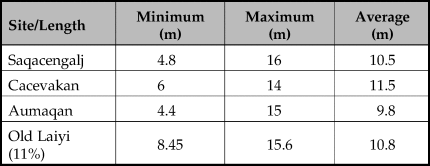
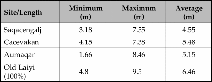
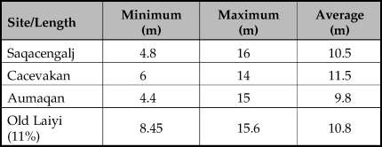
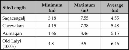
Old Laiyi, one of the settlements of North Paiwan, is located on a slope with terraces that are much longer than those at the South Paiwan Kaushi sites (see Table 3). However, the front yards of some house structures are quite narrow and lacked sufficient space for the additional construction of platforms. Indeed, they may have functioned as linear pathways. The terraces on the slopes where the three Kaushi sites are located are flatter and shorter in length compared with the ones in the North Paiwan Old Laiyi sites. However, the South Paiwan Kaushi site terraces are comprised of buildings that are perpendicular to them and have a greater number of house structures accommodating a front yard and a platform. In contrast, the rectangular house structures at Old Laiyi are parallel to their respective terraces (see Table 1), and both their minimum and average sizes exceed those at the South Paiwan Kaushi site structures. This indicates that the Old Laiyi group may have preferred larger and enclosed spaces for their houses without a front yard or platform (see Table 4); this pattern is a notable contrast from other houses at the three South Paiwan sites studied. These architectural differences reflect choices that were likely governed by variation in their cultural preferences rather than adapted to local topographies. While one group valued having a rectangular house in terrace-parallel orientation and was bordered with a front yard and an attached platform as a means to signal elite status, other groups preferred houses with different orientations that limited the size of a house and even included the addition of a front yard and platform.
Lengths of terraces at the studied sites (Chen Reference Chen2012).
Lengths of rectangular house structures at the studied sites (Chen Reference Chen2012).
The process of spatial construction
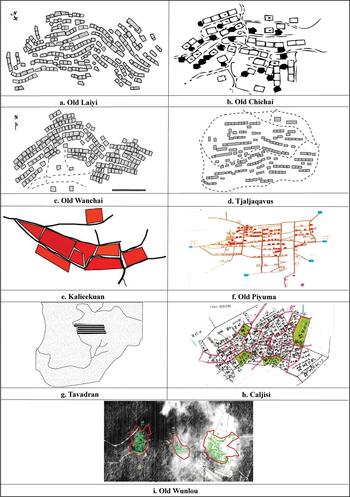
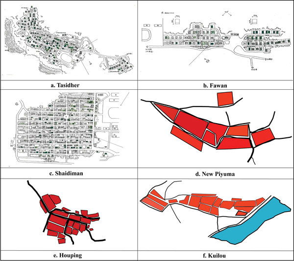
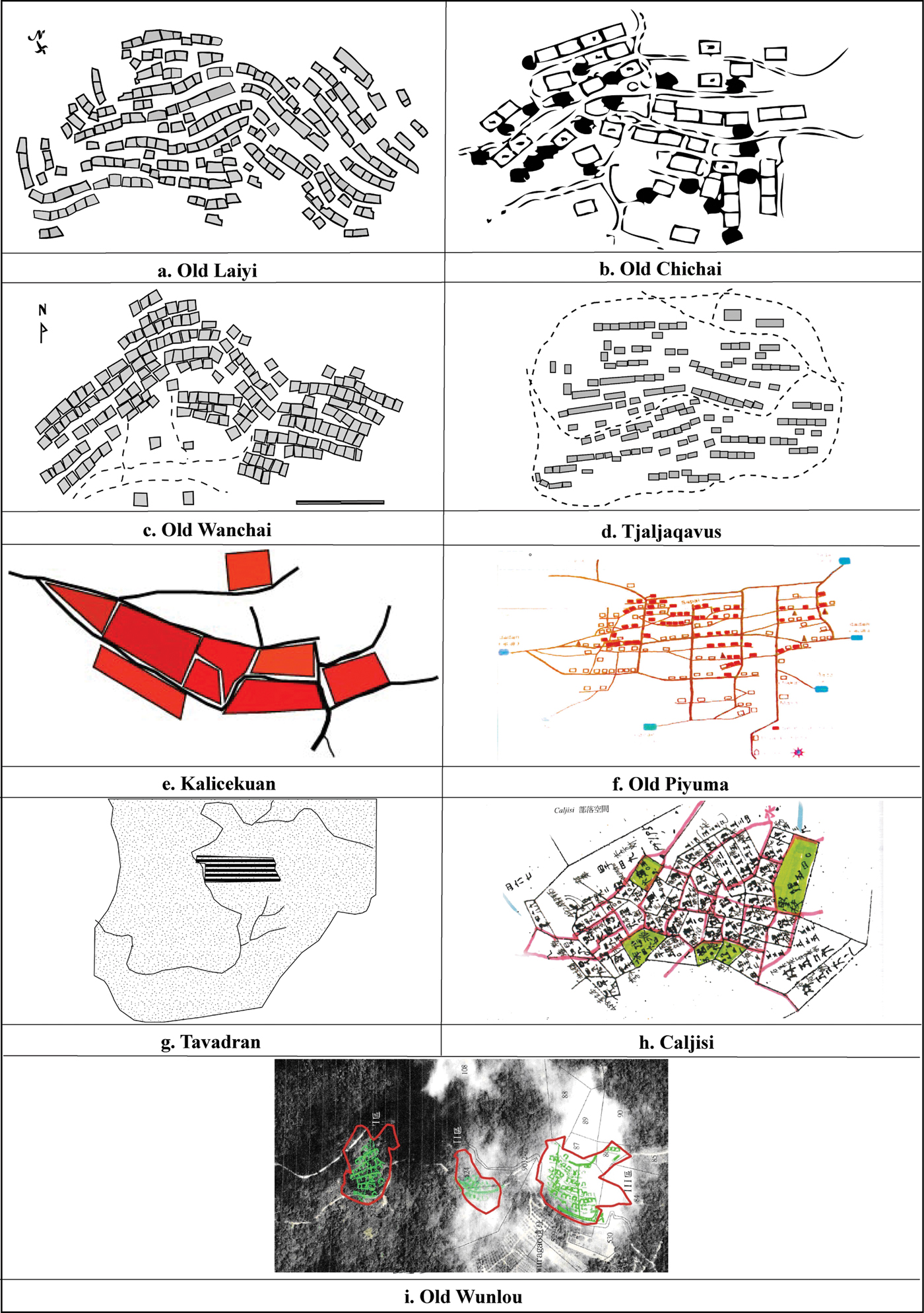
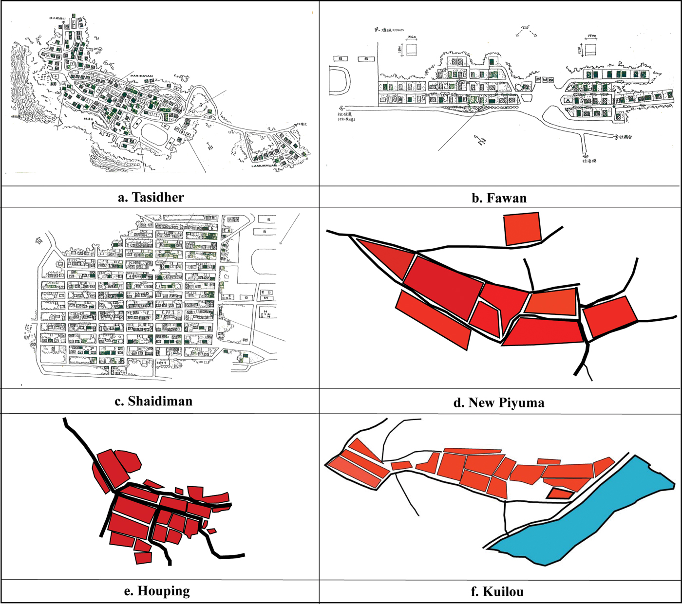
A comparison of the spatial configuration of North Paiwan settlements with the South Paiwan Kaushi sites that were examined for this study reveals a sharp contrast in their orientation. The North Paiwan settlement configurations are frequently parallel to their respective terraces (such as Old Laiyi in C. Li Reference Li1994; Old Chichai in Kuo Reference Kuo2003, 6; Old Wanchai; Tjaljaqavus; Old Piyuma, Tavadran, Caljisi and Kalicekuan in Tung Reference Tung2011; Old Wunlou in S. Kuo et al. Reference Kuo, Cheng, Lin, Huang and Hu2017; see Figure 6), whereas the settlement configuration of sites examined for this study are most commonly perpendicular to their terraces. Indeed, even the ‘new’ (i.e. 21st-century) settlements of North Paiwan are today constructed with an orientation that is parallel to their terraces (see Figure 7).
Configuration of some old settlements of North Paiwan (showing a terrace-parallel orientation). (a) From C. Li (Reference Li1994); (b) From T. Kuo (Reference Kuo2003, 6); (c) Redrawn from document offered by Wanchai Community; (d) Redrawn from old map collection in Department of Anthropology, National Taiwan University; (e) Redrawn from Tung (Reference Tung2011, fig.46); (f) From Tung (Reference Tung2011, fig. 7); (g) From Tung (Reference Tung2011, fig.18). The area filled with horizontal lines is settlement and the area filled with small dots is its cultivation and hunting field; (h) From Tung (Reference Tung2011, fig. 43); (i) From S. Kuo et al. (Reference Kuo, Cheng, Lin, Huang and Hu2017, fig.10).
Settlement configuration of some 21st-century North Paiwan villages (showing a slope-parallel orientation). (a) From Huang (Reference Huang1982, 20); (b) From Huang (Reference Huang1982, 22); (c) From Huang (Reference Huang1982, 21); (d) Redrawn from Tung (Reference Tung2011, fig. 54); (e, f) Redrawn from Google Maps.
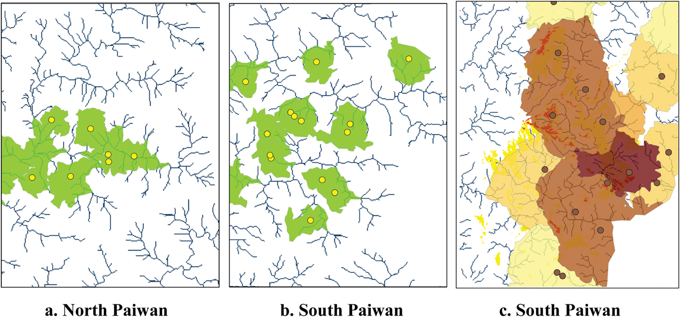
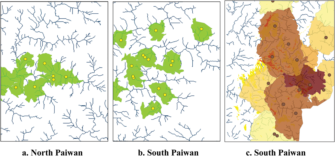
Analyses of site-catchment and visibility of settlements also imply a possible difference in the concept and structure of the landscape between north and south Paiwan groups. An examination of the locations of both South and North Paiwan settlements revealed that most of the North Paiwan settlements are situated on slopes that are relatively close to the primary stream of a river, but dotted in individual river systems with relatively higher visual dominance over their catchment areas. In contrast, the South Paiwan settlements, including Kaushi's, are mostly located on areas that are adjacent to a river's tributary but mostly within a river system with a high visual dominance in that river valley (Wu & Chen Reference Wu and Chen2016) (Fig. 8). Furthermore, the three Kaushi settlements (as well as the 21st-century village that is still occupied to this day) are all adjacent to a small stream and they all exhibit a terrace-perpendicular orientation (Fig. 9). Perhaps the spatial proximity of houses to particular streams held cultural significance beyond the vital need for water in South Paiwan? If so, perhaps the cultural meanings of certain streams dictated the spatial arrangement and orientation of houses and settlements in different locales (e.g. South Paiwan versus North Paiwan).
Spatial distribution of both North and South Paiwan settlements (Wu & Chen Reference Wu and Chen2016). (a) North Paiwan settlements are located relatively close to the primary stream of rivers; (b) South Paiwan settlements are distributed adjacent to a river's tributary; (c) South Paiwan settlements are situated mostly within one river system with a high visual dominance in that river valley (the light to dark shades indicate the visual dominance from low to high).
The orientation of South Paiwan Kaushi settlements alongside their neighbouring streams.
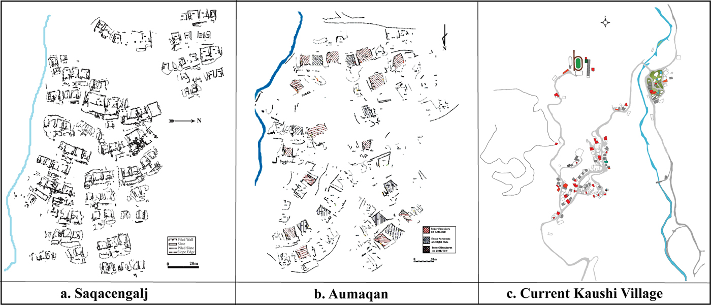
In either case, it is apparent that the spatial arrangement and orientation of houses and settlements on the South Paiwan Kaushi landscape was consistent and repetitive before, during and after periods of migration. The persistence of such patterning across time and across the Kaushi landscape signals the embodiment of cultural choices and preferences and a process of spatial construction with a way of mapping the same idea and conceptualization of landscape onto different lands.
Discussion
Six properties materialize the conceptual metaphors (Ortman Reference Ortman2000) that are indexed by the social use of space: directionality, superordinate, invariance, constitution, blended sources and experientiality. First, there is the property of ‘directionality’, which maps patterns from an original land to a new land and cannot operate in reverse. Second, there is a dimension of the ‘superordinate’: space, household, and community are superordinate to place, house, settlement and lands. Third, there is the principle of ‘invariance’, by which patterns of households are mapped onto durable house structures, community configurations are mapped onto settlements and landscapes are mapped onto lands. Fourth, there is a ‘constitutive’ dimension of patterning in house structures and settlements; this dimension resides in people's minds and it enables them to apply patterns from lands they formerly occupied to new lands they encounter during a migration event. Fifth, there is the dimension of ‘blended sources’ which acknowledges variation in the topographies of old and new lands. Blended spaces are created when old patterns are mapped onto new lands. And sixth, there is the ‘experiential’ dimension in which people engage with a new land as they construct their use of its space. Together, these six dimensions reflect the metaphorical, figurative and conceptual nature of spatial construction.
Cultural continuity among the South Paiwan Kaushi
Ethnographic and historic sources provide insights into some of the social factors that underlie the spatial organization and meaning of indigenous Paiwan houses. A house is more than simply a domicile and economic unit: it is where people are born, where they live their daily social lives and where they are buried. Therefore, the house reflects, and at the same time dynamically structures and shapes, cosmology and social cognition. In other words, the facilities and their arrangement in a house have a socially constructed order and relationships that reflect and transmit cosmological ideas and cultural cognition as it is shaped and transformed through human interaction through time (Chiang & Li 1995). Moreover, the Paiwan are traditionally a ranked society that practised primogeniture in which the eldest child in a family, whether he is a male or a female, inherits the name and property of the family. Land ownership and economic development are tightly bonded to these social structures, and they shape the use, distribution and extension of lands in and around settlements. Settlement patterns and configurations, therefore, are shaped by these cultural and social aspects.
So far, we have no knowledge of the social and cultural factors of the Paiwan groups that established these settlements, apart from that derived from ethnographic and historic documentary sources. Some of the settlements studied might be hundreds of years earlier than others, or overlap with the dates of ethnographic and historic sources. However, ethnographic and historic records do document the tied and complex relationships among cosmology, cognition, economy, land use and settlement patterns among the various Paiwan groups. These ties must have been formed and practised for a lengthy and sustained period of time. Consequently, they became embedded and materialized in the spatial construction of their cultural landscapes.
The shape, size, and arrangement of houses and settlements on a landscape signal the social lives of a community. Spatial characteristics influence people's sense of direction, their conceptualization of space, their bodily movements and the way they organize their daily lives and activities in both private and public areas. The use of space also influences the construction of personhood and its related cultural practices. The shape and layout of house structures and settlements also materializes how a group recognizes, constructs and interacts with its surrounding natural and cultural landscape. Conversely, as in Paiwan societies, social cognition, social, and economic structures also shaped the way that houses, settlements and landscape were constructed.
This study of three archaeological sites in the South Paiwan Kaushi area reveals that the shape and orientation of their house structures and settlements, the layout of their internal features, the size of their adjoining front yards and the presence of a platform was patterned in a consistent fashion. Landscapes typically vary from one another with respect to their topographies and resources. For this reason, people who migrate often encounter unfamiliar lands that must be accommodated with pre-existing cultural imperatives. The configuration of the landscapes that the Kaushi encountered was figurative and their engagement with them was enacted through daily social practices that were analogical and metaphorical. South Paiwan Kaushi people analogized and metaphorized prior landscape configurations onto their newly encountered lands. In so doing, they constructed new houses and settlements onto newly encountered landscapes according to a pre-existing conceptual model. Transferring prior house orientations and settlement patterns to a new landscape entailed the construction of houses in a fashion that echoed their earlier lives. The duplication of houses and settlements in a newly encountered landscape enabled South Paiwan Kaushi to ‘recognize’ and make ‘familiar’ an unfamiliar landscape. Archaeological evidence of recurrent and persistent use of similar house orientations and settlement patterns by the South Paiwan Kaushi across time—and across multiple landscapes—implies that the cultural imperatives and figuratively metaphorical conceptualization that governed this behaviour enabled them to adjust to new lands during periods of migration.
Such archaeological patterning also implies that tightly bonded cosmological and social cognition, socio-economic structures, meaning, identity and collective memory were constructed through (and embedded in) the construction of houses and settlements. By adhering to rule-bound cultural imperatives in their daily practices, including the construction of houses and settlements in newly encountered landscapes, the South Paiwan Kaushi people maintained their social and cultural factors, and also social connections with one another and their shared past.
Conclusion
In this study the configuration and layout of house structures and settlement at three South Paiwan Kaushi sites were examined. This analysis reveals that these three settlements share at least some common characteristics and patterns with North Paiwan settlements. However, some South Paiwan Kaushi site characteristics, such as building and settlement layout and orientation and the presence of a front yard and a platform, are strikingly different from those of the North Paiwan settlements. Moreover, these particular differences are consistent and repetitive. The two settlement locales (i.e. South Paiwan Kaushi and North Paiwan) indicate that their founding populations brought their particular cultural preferences with them as they migrated and established new settlements in what were initially unfamiliar landscapes.
If the three sites examined for this study are representative of certain times and places of the Kaushi in South Paiwan, it is possible that they also shared certain characteristics with sites in North Paiwan sites. If such a pattern were documented, it might be the hallmark of a common tradition throughout Paiwan. However, the Kaushi sites in South Paiwan share similarities with one another that they did not share with sites in North Paiwan. It is apparent, therefore, that patterning in South Paiwan was localized to that particular area. Diversity in the use of space among different Paiwan subgroups indicates that each subgroup developed a distinctive culture and society as they adapted to their respective historical and environmental contexts. These findings corroborate information in the ethnographic and historic sources that indicate that, although both North and South Paiwan shared a variety of social and cultural factors, variation in some of these factors (i.e. spatial construction and cosmology, social cognition, socio-economic structures and land use) varied as they encountered and settled new places. Moreover, they also imply that during periods of migration people used the construction and layout of their space, such as houses and settlements, to materialize pre-existing cultural imperatives that were both analogical and metaphorical. This enabled them to perpetuate certain cultural practices and social memories in the face of change.
The oral histories and archaeology of Kaushi sites in South Paiwan and North Paiwan should be subject to more intensive research so that it will be possible to illuminate further how the social and spatial construction of their cultural landscapes was materialized in these indigenous societies. In the meantime, the methodology and interpretations of this study offer an alternative strategy for considering patterning in the archaeological record. For example, patterns in the layout and orientation of house structures and settlements might also be formed as the iconography of such functions as the decoration pattern on textiles or pottery, and such patterns should be investigated to infer the metaphorical conceptualization of space in such materials. In any event, it is apparent that repetitive pattern in the construction and configuration of houses, settlements and landscapes—across time and across landscapes—signals a metaphorical, figurative and conceptual process that is governed by cultural preferences. Documenting such patterns enables archaeologists to ascertain the analogical and metaphorical dimensions of different social groups during historical periods of movement and migration.
Acknowledgements
I am sincerely grateful for the support and assistance that I received from the Kaushi villagers, friends and students in carrying out the fieldwork that made this study possible. I also extend my thanks to the Wanchai Community for providing me a map of their settlement. Finally, I appreciate the kind assistance of James Bayman in reading and editing this paper.
Funding
This work was supported by Chiang Ching-kuo Foundation for International Scholarly Exchange (grant number RG006-D-08) and Ministry of Science and Technology (grant number 104-2627-M-002-024).