

Introduction
When landed property was defined in the medieval Mediterranean, many boundary clauses were described in ways which still loosely resembled model compositions of limites drawn up in Classical Roman texts, even if direct knowledge of that surveying and notarial ancestry was exceptional – and, more usually, non-existent. In itself, this observation is of no great consequence since it is well known that the art of land surveying in the Middle Ages had radically changed from that of Antiquity when professional agrimensores, experts in geometry and trigonometry, fastidiously noted every type of land, limit, local idiosyncrasy and cause of dispute.Footnote 1 The methodical precision of the ars gromatica rarely troubled the medieval notary. No longer was it standard practice to illustrate a work with sketches; to explain precedents, customs and jargon of land tenure, or, indeed, to link land survey, settlement and viability with cartography, cosmology or wider regional subdivision.Footnote 2
It is equally obvious to note how political, legal and socio-economic relationships between landholder and the land were fundamentally different to those of later lordships in the Latin West, Byzantine East or, indeed, between a Mediterranean Muslim ruler and his salaried troops and officials. The colonising policy of the Roman Empire with its orderly resettlement of army veterans in the first centuries bc and ad were processes inconceivable to any medieval ruler, and the quintessential techniques of Roman surveying, a function of such imperial mandates, all but lapsed in the medieval Latin West and Balkans.Footnote 3 Instead, there was a far more haphazard approach to land definition with little effort made to measure boundary lengths and hardly ever any attempt to calculate the surface area of an estate.
However, not all ancient practice was discontinued. In the south of the Italian Peninsula for example, during and after the Norman period when document survival for the region improves significantly, echoes of Roman land surveying techniques are detectable in charters and cartularies. The notion that plots of land should be ideally conceived as quadrilateral had endured, and boundary markers were still of avail, albeit irregularly set, sized and devoid of any pagan aura.
But the most striking links to the past were in the orientation of estates. In particular, the order in which boundaries were recorded when their limits were assigned cardinal points. In these descriptions, confines predominantly began ab oriente running laterally from a point at the top of the eastern limit. This system derived directly from the ancient Roman custom of land division. On this, its most basic precept, the early gromatic writer Julius Frontinus reflected how ‘our ancestors . . . first drew out two limites, one stretching from east to west, which they called the decumanus, the other from south to north which they called the kardo’.Footnote 4
Boundary clauses in pre- and early Norman Italy
Across the south Italian mainland, the period from late Antiquity to the early eleventh century is marked by a relative lack of charter materials. In part, this is due to questions of document production, but it is also due to document loss, which in many regions, such as Byzantine and Islamic Sicily, is extreme. From the twelfth century, a relative proliferation of charter material resulted from increasingly sophisticated forms of civil governance and complementary roles played by trained, literate functionaries.Footnote 5 Ironically, this period of nascent bureaucracy, which inflated the importance of documents as instruments of command, control and legitimacy, coincided with the rise of those most illegitimate and illiterate of newcomers – the Normans – who carved out new demesnes from which parcels of land could be granted. Norman patronage of ecclesiastical lordships generated new, and renovated old, institutional frameworks for the conservation of charter and cartulary materials, thus providing both means and motives for increased document production and conservation. Territorial consolidation and record-keeping further promoted the status of trained notaries, while also reinforcing the association between religious houses and the comital (later royal) administration on the one hand, and the scribal classes on the other. Indeed, it was through their agency that the outcomes of boundary inquests were expressed in the idiom of diplomatic and legal formularies, not the language of the landholders or that of the local boni homines, kaloi anthrōpoi or shaykhs. So in spite of reliance on oral testimony of the above parties, written boundary clauses in Latin, Greek or Arabic seldom contained any element of spoken vernacular.
The demarcated, straight-line rigour of Classical Roman boundaries reduced the need to record the precise course of limits. But with the dereliction of this system, emphasis shifted to noting the physical attributes of land which lay on the limits themselves, fixing a location either by citing that of adjacent properties, with boundary sides designated by number (‘the first part is from the land of so-and-so’);Footnote 6 or in terms of limits with an upper and lower ‘head’ or caput, each appended with a flank (latus);Footnote 7 or by orientation (‘from the east there is such-and-such’).Footnote 8 Cartulary collections, such as those compiled by the Longobard scribes of Cava, tended towards relatively fine descriptions of physical relief and included data relating to land use. However, in many Latin charters, landed property was given cum omnibus pertinentiis, rarely specifying what those things were.Footnote 9 Such styles of composition in grants, endowments, conveyances, deeds of sale and purchase can be found in all areas where Latin notaries operated.
Shades of difference existed within these debased, Romanised schemes, as Jean-Marie Martin has shown in a cursory assessment of terms used in notarial acts to depict the rural landscape of south Italy.Footnote 10 While stressing broad uniformity interrupted by local variation contingent on both scribe and terrain, Martin found the sharpest distinctions to be in pre-Norman Campania, between the scribes of the curiales in the duchy of Naples and the Longobard notaries of the principality of Salerno, particularly Cava. Although the former were generally more conservative and closer to the practices of late Antiquity than their Salernitan counterparts, both ‘schools’ harmonised during the first half of the tenth century and defined limits with cardinal points or with numbered sides around plots conceived as quadrilateral.
Land survey models of the eastern Roman Empire
Classical Roman land surveyors were never sure why they set out land boundaries ab oriente, but they associated it with pagan practices from a time immemorial.Footnote 11 Over the course of the next millennium, the concept of the east as the foremost of bearings was increasingly bound up in Christian thought with the orientation of churches, heaven and holy Jerusalem.Footnote 12 The east even gave rise to the popular eastern Christian name, Anatolius.Footnote 13 For Gervase of Tilbury, echoing Augustine of Hippo, the sequential arrangement of cardinal points in Greek revealed the primordial, quadripartite division of the earth.Footnote 14 Why else would the initial letters of ἀνατολή (‘east’), δύσις (‘west’), ἄρκτος (‘north’) and μεσημβρία (‘south’) spell out the name of A-d-a-m? Although this did not entirely resolve the problem, the long-held view of prioritising and outlining the first land boundary from the east continued long after the fall of Rome, not least in the Eastern Empire where the Classical principles of surveying were more deeply ingrained than in the Latin West.
In medieval Greek, didactic treatises on land definitions (περιορισμοί) were as detailed as their Classical Latin predecessors, and continuities between these cognate traditions are easily recognisable: the use of specialist scribes and surveyors; the compilation of cadastral records; the classification of land types; the use of boundary markers, and ways to measure boundary lengths.Footnote 15 Origins of the art were often attributed, not incorrectly or without precedent, to pharaonic Egypt.Footnote 16 Nevertheless, in both theory and practice, there remained the same propensity to sequence cardinal directions and to begin a boundary clause with reference to the east. These were set out in archetypal models, such as this:
First, write the boundaries in order like this; taking the east as a start they lead away to the west leaving the property of so-and-so on the right where there stands a tree, an olive, myrtle, pine or plane, or a river or stream. To here, there are fifteen rope-lengths. It turns back, rises to the south leaving the fields of so-and-so on the right, and they go straight on until some-such place in which there is a rocky mound and a bay tree that has a cross, letters or a certain mark, by which point it has taken 100 rope-lengths. It turns to the east, continues right along the road that is the one leading from a certain castrum, leaving the property of so-and-so on the right and the trees planted in a row there. On them is found a mark drawn on high, a cross made as a sign for all; and going straight on, it reaches a certain spot completing a measure of 200 rope-lengths. Next they go away eastward for a little and downhill to the bend of a certain river where the measure is found to be fifteen rope-lengths. It curves back to the south, goes straight on, leaves on the right someone's vineyard, and downhill to the boundary of so-and-so's field in which there is an ancient mound where it is necessary to renew the place-marker, show the truth and keep the neighbours’ peace. There, the rope-lengths are found to be thirty-five. Then they head off again to the east leaning up against the boundary and the property of so-and-so where a large rock is planted; the measure to here is found to be twenty-five rope-lengths. To the north again, they go along the road of the village heading straight towards the seashore joining the boundary where the start began, and where there are again found to be fifteen rope-lengths.Footnote 17
It should be reiterated that some scribes adhered to such prescribed ideals more closely than others, and many definitions did not even include references to boundary sides. Moreover, it is unfortunate that the bulk of surviving evidence in Greek comes from the fourteenth and fifteenth centuries, much relating to the Balkans, at times and in places where limits were not always plotted systematically.Footnote 18 Nonetheless, Greek boundary-clause models consistently followed the same principles as seen in the three examples below:
Consider the directions when starting a survey, and write down the notable parts quite precisely, pointing out the start, end, and any change to the direction. Thus, a field of such-and-such a person starts from the east, runs to the west, turns to the south until it reaches a certain spot, back to the east to a particular known point, and turns back up to the north.Footnote 19
Much as you must also know the directions well: the east, the west, the north, and the south. For the east is always the top (κεϕαλή) boundary.Footnote 20
Land surveying on the level comprises directions, observation points, lines and angles; it includes types, forms, figures, and principles. There are four directions – east, west, north, and south.Footnote 21
In former Byzantine areas of southern Italy, including Latinised regions such as Apulia, the strong tendency to begin with reference to the east remained.Footnote 22 Further to the south, in Calabria, southern Basilicata and the Salento Peninsula (Terra d’Ótranto), where Byzantine notarial influence persisted and where Greek-speakers were more in evidence, the basic principle of conceiving land units as quadrilateral and of beginning their limits with reference to the east was also more standard than not.Footnote 23
Arab-Muslim land surveying
The meagre pickings scattered in papyri, narrative texts and borrowings from Greek into Arabic which relate to landholding, settlement and tax-collection in the century after the Arab conquests of the Byzantine Near East show that much of the existing infrastructure, including local officials, their administrative memory, terminology and savoir faire was carried forward into the Islamic period, even if the dynamics of land grants, landholding and lordship in the Islamic world were to evolve in quite different ways.Footnote 24
Under the Umayyads, the population census (iḥṣāʾ) and land survey (masḥ or tāʿdīl) remained basic, if irregular, tools of post-conquest authority, control and organisation.Footnote 25 The first gauged revenues from the jizya or religious head-tax payable by non-Muslims; the second served to estimate and, if necessary, adjust the amount of income obtainable from the land. As a result, it was the names of landed properties, their taxable value and fiscal relationship with landholders and/or the treasury which tended to be documented in state registers, rather than the physical limits of the estates themselves.
Gathering and confirming essential data of this type in this way continued into later periods, exacerbating points of differentiation with non-Muslim regions where there was a more diverse range of record-keeping landlords for whom land use, rights, obligations and fiscal dues were inextricably linked to the act of describing boundaries for cartularies, inventories, concessions, sales and endowments. Instead, in the Islamic world, clearer lines of separation materialised between cultivation, productivity and state taxation strategies on the one hand, and the legally correct way of drawing up acts of alienation by trained Muslim jurists on the other. Thus, there is nothing in the treatises of Ibn Mammātī and al-Makhzūmī which explains how to make boundary definitions of landed estates, regardless of the wealth of other information relating to agronomy, agricultural surveys or tax assessment procedures.Footnote 26
Document loss narrows our view of medieval chancery practice, but even so evidence of a Muslim fiscal administration routinely engaged in defining actual estate boundaries remains scarce. An exception, and also one of the earliest boundary clauses in Arabic, resulted from a land grant (qaṭīʿa) in Mosul made by the caliph al-Muʿtamid to make taxably productive a large, uncultivated plot on the city's outskirts by the Tigris river. Dating from 754, the limits were recorded by al-Azdī in his tenth-century regional history.Footnote 27 The chronicler had personally seen the original document (kitāb) and cited the boundaries verbatim. With a quadrilateral outline, point-to-point markers and assigning of cardinal directions to boundary sides, it bears tantalising, familial resemblances to European counterparts, distinguished only by an estimated area.Footnote 28 But beyond the superficial, there is nothing of substance to link it to any identifiable precedent.
While it is unusual to encounter detailed definitions made in Arabic by scribes of state offices or religious institutions, it is common to find descriptions of landed property in private deeds of sale. Moreover, after the first century ah, with increasingly refined articulation of Islamic thought by scholars and theorists, even the most mundane boundary delineations fell within legal, theological and cosmological frameworks constructed to define and regulate ideas of sacred geography.Footnote 29 By and from the 800s, when boundary clauses are attested in greater numbers, an empirically observable point of difference emerges between the Muslim ordering of boundaries and the ‘Romano-Byzantine’ arrangement. In the Arab-Muslim world, pole position went to the southern limit (al-ḥadd al-qiblī), not the eastern one, as the first to be described.Footnote 30
Why the south-first archetype became standard in Muslim land surveys is easier to guess than to ascertain with confidence but we need not be embroiled here in the debate about the qibla as the chosen direction of prayer for Muslims, since issues surrounding this were settled before Muslim legal tradition recognised al-qiblī (‘the south’) as pre-eminent among directions.Footnote 31 Less speculation is needed to explain the diffusion of the south-first model. For this, the efforts of Muslim jurists to reconcile legal theory and implementation, while ensuring that the parameters of orthodox practice were not exceeded, fostered a prodigious output in ʿilm al-shurūṭ (‘the study of contracts’).Footnote 32 In tandem with other peripheral branches of the law, such as records of court minutes, verdicts and legal stratagems, they established and propagated formularies and paradigms as practical, professional aids for qāḍīs (judges), jurists, officials and scribes. By the end of the 800s, a unified notion of how a south-first ‘Islamic’ boundary definition should be written was as widely accepted as it was disseminated. On occasion, shurūṭ authors accompanied their boundary definition models with explanatory passages, such as this from al-Sarakhsī's eleventh-century Kitāb al-Mabsūṭ:
The first boundary: from the direction of the south there is the house of so-and-so. The second boundary: to the east of the house is the house of so-and-so. And the third boundary: north there is the house of so-and-so. And the fourth boundary is western: the house of so-and-so. As the direction of the qibla is the most noble of directions (ʾashraf al-jihāt), so its foremost part is the start.Footnote 33
Thus, in an Egyptian papyrus relating a house sale in Alexandria from the year 820, the boundaries were given as south–north–west–east.Footnote 34 Other Arabic deeds of sale from the ninth- and tenth-century Egypt also begin with the southern boundary and proceed to cite the northern, eastern and western limits.Footnote 35 In a Syrian papyrus from the ninth century, we read that ‘the first boundary: to the south there is the village [text missing], and the third boundary: there is, to the north the village of Burayj; and the fourth boundary: from the direction of the west’.Footnote 36 In sales of two estates outside Damascus in the year 922, the boundaries of both began min al-qibla, and then ran east–north–west.Footnote 37 Moreover, the south-first model endured: in twenty deeds of sale, purchase and conveyance, mainly relating to houses in Cairo from the 1400s, all begin with the southern boundary, continuing north–east–west thereafter.Footnote 38
Shurūṭ works, also known as wathāʾiq among the Mālikī jurists of the Iberian Peninsula and North Africa, may again provide a point of transmission, this time between Egypt–Syria and the south-central and western Mediterranean. The works of Ḥanafī shurūṭ scholars such as Ibn ʿAbdūn, qāḍī of Qayrawān in 888 ad under the Aghlabids, were widely consulted, influential – and now lost.Footnote 39 In any event, beginning with the south as ‘the noblest of directions’ was also the Andalusi practice as prescribed by the eleventh-century shurūṭ scholar Aḥmad al-Ṭulayṭulī (‘from Toledo’).Footnote 40 Deeds of sale from fifteenth-century Nasrid Granada show how the south-first model was a lasting one.Footnote 41 But such firmly rooted practices in Muslim al-Andalus were not pervasive to all parts of the Iberian Peninsula, as examples from the Catalonian cathedral of Sant Pere de Vic and others indicate, which tended to define properties with the east first.Footnote 42 Significant is an apparent switch between styles in pre- and post-Reconquista Toledo revealing how the south-first model was expressly linked to Muslim notarial practice before its fall in 1085. Thus, in an Arabic deed of sale dated to Ramaḍān 475 ah/ad 1083, the boundaries of a vineyard were given as south–north–east–westFootnote 43 However, the boundaries of ‘Mozarab’ Christian deeds of sale thereafter tended to begin with the east.Footnote 44
The contrasting formulae from different administrative–religious traditions are sufficient to form the basis of a typology that can be tested against charter evidence from frontier zones in order to establish questions of continuity, disjuncture and the co-existence of land survey practices. At this point, we can return to the central Mediterranean and the contested island of Sicily which from 535 to 827 had been under the Byzantines, and then under Muslim rule until the fall of Palermo to the Normans in 1072.
Boundary delimitations in Norman SicilyFootnote 45
In the 1090s, when the piecemeal Norman Conquest and pacification of Muslim Sicily was complete, two types of document emerged to confirm the details of granted lands and men: lists on which the local population was registered, and descriptions confirming the boundaries of conceded estates. In Greek, these were generally known as plateiai; in Arabic, they were called the jarāʾid al-rijāl (literally ‘lists of men’), and the jarāʾid al-ḥudūd (‘lists of boundaries’). Examples are known from comital and royal charters as well as from later cartulary collections. In the absence of any trained cadre of Latin scribes on the island, the Norman rulers’ early use of Arabic and Greek, later combined in bilingual confirmations, is striking. Also of note is that Latin charters purport to date from this early period, but almost all are later copies, known forgeries or of dubious authenticity.Footnote 46
The jarāʾid lists were to become the main written instruments of the Arab-Norman Dīwān or royal fiscal administration which managed estates and men of the royal demesnes in Sicily and Calabria.Footnote 47 Yet, the precise origins of the jarāʾid are difficult to ascertain, not least because no charters have survived from either the Byzantine or Islamic periods. Even in the Norman period, there are no extant Arabic documents before the 1090s; nor were any apparently issued from 1112 until after the foundation of the kingdom in 1130.Footnote 48
As for the ‘lists of men’, it is now accepted that they were based on pre-Norman precedents as it can be inferred that they had been compiled with reference to pre-existing Arabic records.Footnote 49 But the precedents for the land boundaries remain obscure – frustratingly so, because Norman Sicilian rulership is conspicuous for its borrowings from the Latin West, Byzantium and from the Islamic world, including the combined use of three languages in the royal palaces, and three diplomatic traditions in the royal chancery.
So, how original was the Norman land registry tradition in Sicily? Did it also have local Arabic roots from the Islamic period? Or had ways of defining limits been introduced with the Normans, perhaps from Latin Longobard or Byzantine Greek areas?
The orientation of boundaries in Sicilian Arabic charters
Of the earliest surviving, authentic, post-Norman Conquest land grants, those written in Greek are prominent, such as the description of the newly constructed kastron of Focerò in north-eastern Sicily, whose limits were composed in Greek from scratch in the mid-1090s on the order of Count Roger I himself.Footnote 50 The proceedings were overseen by twelve ‘archons’, almost all of whom had Greek names and some of whom can be identified with influential kin groups from around the area.Footnote 51 Recently, both this hilltop site and its extensive boundaries have been identified, and we now know that they began from the east, from a point at the top of the eastern limit.Footnote 52 Indeed, of the earliest examples of boundary clauses in Sicilian Greek with specifically named boundary sides, the vast majority open with reference to the eastern boundary first.Footnote 53
Arabic boundary descriptions made under the Norman rulers are in relatively short supply and are attested later. The earliest is a bilingual (Greek–Arabic) copy of a confirmation from 1133, in which the Arabic was based on the Greek.Footnote 54 The first monolingual boundary clause from the royal Arab-Norman Dīwān comes even later, in 1141.Footnote 55 Of all Arabic boundary clauses, the largest and most coherent corpus is found in a royal confirmation of lands granted to the church of Santa Maria Nuova at Monreale.Footnote 56 These were definitions of open villages and fertile farmlands in western Sicily – well-populated areas that had been overwhelmingly Muslim since the ninth century. The boundaries of four large provinces and some fifty of their internal estates were described in detail.Footnote 57
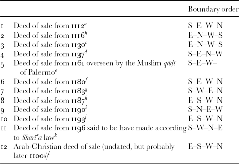
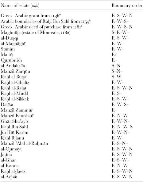
When the data for Arabic boundary clauses is set out, there is a clear difference between private acts of alienation on the one hand and royal charters issued by the Norman Dīwān on the other. As can be seen in Tables 1 and 2, the private documents are mixed, but boundaries began mainly with the south – as if composed by Arab-Muslim scribes cognisant of the received ‘Islamic’ model.Footnote 58 However, confirmations of lands drawn up in Arabic and issued by the royal Dīwān opened mainly with the east in the ‘Roman’ Christian way.
Private deeds of sale from Sicily with boundary definitions in Arabic

a al-ḥadd al-qiblī . . . al-sharqī . . . al-ḥadd al-gharbī . . . wa-’l-dabūr min-hi. Cusa, I diplomi, 610–13 (611). b Known from a Latin transumpt of 1266, see Bresc, ‘La propriété foncière’, 93–6. c Latin transumpt of 1255, see Bresc, ‘La propriété foncière’, 96–9. Here, an estate in western Sicily – Raḥl Karrām – was named after the Muslim family who owned it (not simply held it), and was sold by them for 1,000 tarì to a Christian buyer. d al-ḥadd al-qiblī . . . al-ḥadd al-sharqī . . . al-ḥadd al-dabūrī . . . al-ḥadd al-gharbī. Cusa, I diplomi, 61–7 (62). e al-ḥadd al-qiblī . . . wa-sharqī-hā . . . wa-gharbī-hā. Cusa, I diplomi, 101–6 (102). f al-ḥadd al-qiblī . . . al-ḥadd al-sharqī . . . al-ḥadd al-gharbī . . . al-ḥadd al-dabūrī. Cusa, I diplomi, 39–43 (40). g fa-ḥadd-hā al-qiblī . . . al-gharbiyya . . . wa-sharqī-hā . . . wa-ẓahr al-qibla min-hā. Cusa, I diplomi, 491–3 (491). h Latin transumpt of 1282, see Bresc, ‘La propriété foncière’, 99–101. i min jiha qibliyya . . . bi-dabūri-hā . . . wa-sharqī-hā . . . wa-qiblī-hā (sic) . . . wa-gharbī-hā. Cusa, I diplomi, 44–6 (44). j al-ḥadd al-sharqī. . .al-ḥadd al-qiblī. . .al-ḥadd al-gharbī. . .wa-’l-ḥadd al-rābīʿ wa-huwa dabūr al-qibla. Cusa, I diplomi, 496–8 (496–7). k al-ḥadd al-qiblī . . . al-ḥadd al-gharbī . . . wa-dabūr al-qibla . . . wa-’l-sharqī. Cusa, I diplomi, 499–501 (499–500). l al-ḥadd al-sharqī . . . wa-’l-qiblī . . . wa-’l-gharbī . . . wa-’l-baḥrī. Cusa, I diplomi, 505–6 (505).
Royal estates with cardinal-pointed boundary sides in Arabic

a The original Arabic parts of the text are lost and survive only in later Latin and Italian translations of the Greek. Indeed, it is not even clear whether the boundaries were ever described in Arabic. Here, the boundary directions are taken from the Greek periorismos. See Cusa, I diploma, 115–16. b See Jeremy Johns and Alex Metcalfe, ‘The mystery at Chúrchuro: conspiracy or incompetence in twelfth-century Sicily’, Bulletin of the School of Oriental and African Studies, 62/1 (1999), 226–59, (esp. pp. 248–52). c al-ḥadd al-sharqī . . . al-ḥadd al-gharbī . . . wa-’l-qiblī . . . wa-dabūr al-qibla. Cusa, I diplomi, pp. 622–6 (pp. 624–5). The order of the boundaries in the Greek, which precedes the Arabic, is the same: τὸ ἀνατολικὸν, τὸ δυτικὸν, τὸ νοτιὸν, τὸ βόριον (ibid. p. 623).
Conclusions
In view of 250 years of Arab-Muslim rule in Sicily before the Normans, it is slightly surprising to find royal chancery scribes writing out boundaries in Arabic based on a Romano-Byzantine orientation model. There seem to me two plausible, but very different, explanations for this. The first is a conservative argument of long continuity: namely, that during the Islamic period, scribes drew on existing Byzantine records, superimposing new boundaries over old, but writing out subsequent descriptions in Arabic. Hence, the Arabic boundaries of Norman crown lands still started with the east.
This possibility, however, is a problematic one given the prevailing tendency for scribes everywhere else in the Islamic world to follow a south-first model in Arabic. Moreover, in Sicily, the protracted processes of conquest are likely to have dislocated old Byzantine boundaries – processes which continued with the division of imperial and ecclesiastical latifundia; colonisation and settlement from Ifrīqiya; the subdivision of property due to the literal application of Mālikī inheritance law which advocated splitting lands between heirs, and the ‘green revolution’ which can only have disrupted the rural landscape yet further. As such, there are many reasons to believe that Byzantine estates’ boundaries could not have survived unadulterated throughout the Islamic period until the time of the Normans in the eleventh and twelfth centuries.
Moreover, the evidence for administrative records from Fatimid times prior to the Norman Conquest points primarily to the use of population censuses: recording the people on the land whose memory confirmed its limits, rather than defining the actual land boundaries themselves in writing. Indeed, this might explain the absence of any claim to lands in the Norman period on the pretext of some older documentation in Arabic. Otherwise for the Islamic period in Sicily, we can at best infer the existence of state records for landed property, perhaps with lists of provincial officials, landholders and presumably some estimate of land tax revenue. But there is too little evidence to go beyond this or to assume that they had compiled cadastral registers of detailed physical boundary descriptions.
An alternative explanation may offer a solution to this dilemma. Recent studies of the royal Norman Dīwān have shown the extent to which it was a confection of the Norman kingdom post-1130 under Roger II and his chief minister, George of Antioch.Footnote 59 It was also a late developer: after the period of 1112–30 when no documents in Arabic were apparently issued at all, the first boundary definition to be written using only Arabic is not attested before the 1140s. Moreover, when royal Norman charters in Arabic were reintroduced, they were characterised by the presence of non-Arabic loan terms, and occasional references to people and events of the 1100s.Footnote 60
This scenario suggests a very different reason for the ‘Romano-Byzantine’ influence in Arab-Norman chancery documents; namely, that the Arabic boundary clauses were actually a modern product of Roger II's day when land inquests to verify property conceded to, or disputed by, newly privileged landholders were overseen by Christian officials familiar with the conventions of Byzantine land inquests. From time to time, the findings of these were written out by scribes of the newly created royal Dīwān in Arabic. On the face of it, their elegant external features had the style and hallmarks of Arab-Islamic chancery documents, but their content reveals a distinctly non-Muslim provenance. Such a scenario fits well with the known development of the Norman bureaucracy from the early days of territorial reorganisation in the post-conquest period of the 1090s when bilingual (Arabic–Greek) functionaries and officials rose to prominence as agents, authors and actors in the comital and royal entourage.Footnote 61 Was it these ‘go-to’ men, the Christian archons, amirs, strategots and scribes of the early Norman rulers, who had been responsible for initiating this change of course in post-Islamic Sicily?
This is a tentative conclusion by way of a suggestion. But even so, the royal charter evidence appears to indicate that the Arabic boundary documents of Norman Sicily had no diplomatic connection with the Arab-Muslim past.