Introduction
Angkor Wat, as with most Angkorian temples, stood at the centre of a large walled enclosure. Abundant scholarship exists on the art history and architectural details of Angkorian temples, but little attention has focused on the structure and function of the large rectilinear spaces that surround them (Fletcher et al. Reference Fletcher, Evans, Pottier and Rachna2015: 1390). Consequently, historians’ models of Angkorian temple enclosures as ‘sacred cities’ or ‘temple-cities’ (e.g. Cœdès Reference Cœdès1941; Stern Reference Stern1951; Coe Reference Coe1957: 410; Jacques Reference Jacques1997: 138–42; cf. Pottier Reference Pottier2000; Evans Reference Evans2007: 24–27 for historical reviews) have not been tested. Archaeological work is needed for such research (Higham Reference Higham2000: 357) and forms the subject of this study.
Most of the Angkorian state's largest temple monuments were dedicated to specific Hindu gods; Angkor Wat was dedicated to Vishnu (Fletcher et al. Reference Fletcher, Evans, Pottier and Rachna2015: 1389). It was built during a time when Saivism predominated and Angkorian Khmers absorbed Brahmanic and Buddhist ideologies into their ritual practices (Briggs Reference Briggs1951: 194). Temples such as Angkor Wat hosted ritual performances, collective and individual, for the benefit of the deities enshrined within their walls. Priests, ritual specialists, pilgrims, ascetics and devotees performed pūjā (or prayer rituals) to worship deities in temple ceremonies, festivals and events. These activities required space and resources. Ritual specialists, attendants and musicians organised ceremonies. Guards staffed the enclosure gates; gardeners cultivated floral and spice offerings; cowherds provided milk and butter from their herd for rituals; and the temple manager and accountants organised finances. Cooks, tailors, carpenters, weavers, washermen, masons, architects and labourers also supported the temple's infrastructure.
Identifying where these people lived and worked requires archaeological research in forested settings with light surface artefact patterning. Evidence for use of the areas within Angkorian temple enclosures has remained largely obscure. The Greater Angkor Project (hereafter GAP) methodology combines analysis of remotely sensed data with field-based archaeological investigations to explore Angkorian settlement patterns. This paper explores residential planning during the Angkorian period (twelfth century AD) and the early part of the post-Angkorian period (fifteenth through seventeenth centuries AD).
We couple GAP research with data from the Lower Mekong Archaeological Project (hereafter LOMAP), whose 2003–2009 research investigated pre-Angkorian settlement patterns (sixth to eighth centuries AD) in southern Cambodia. Both projects are located in Cambodia's lowlands, from which shared writing and art styles emerged by the sixth century AD (Stark Reference Stark, Bellwood and Glover2004, Reference Stark, Schwartz and Nichols2006a, Reference Stark2006b; Heng Reference Heng and Haendel2013). This work, and research in neighbouring north-east Thailand, suggests continuity across space and through time in basal and Khmer settlement units (Welch Reference Welch1997; Evans Reference Evans2007). Tracing the long-term development of Khmer settlement-forms offers insights into Angkorian residential planning within and near temple enclosures.
Khmer settlement patterns
Researchers have studied Angkorian settlement and urbanism for nearly a century (e.g. Coe Reference Coe1957; Groslier Reference Groslier1974; Pottier Reference Pottier2000, Reference Pottier and Haendel2012; Gaucher Reference Gaucher2004; Evans et al. Reference Evans, Pottier, Fletcher, Hensley, Tapley, Milne and Barbetti2007), and growing evidence from the pre-Angkorian period indicates that Khmer socio-political organisation extends back 200 years before the founding of Angkor (e.g. Vickery Reference Vickery1998). Figure 1 locates Angkor Wat, Greater Angkor and the LOMAP survey area. Few researchers have documented Angkorian residential space (e.g. Gaucher Reference Gaucher, Karlström and Källén2003; Bâty Reference Bâty2005); none have studied households as an analytical unit. As archaeologists define ‘household’ differently (Pluckhahn Reference Pluckhahn2010: 338–39), we focus on co-residential groups that used occupation surfaces, features and artefact assemblages associated with dwellings that stood on some or most mounds visible throughout the outer enclosure (e.g. Nash Reference Nash2009: 224).
Map of Greater Angkor, including the sites mentioned: inset top left, regional view; inset bottom left, detail of the central urban area; data courtesy of NASA-SRTM, JICA, Damian Evans and Christophe Pottier.

We use the term ‘settlement configuration’ to describe clusters of archaeological features that recur across the landscape and circumscribe larger social arrangements (see also Evans Reference Evans2007: 154–58). Settlement configurations are surface phenomena, measurable using ground-survey techniques and airborne and spaceborne remote-sensing technologies. We readily acknowledge that our conceptual framework overlooks both short-term and long-term spatial activities described previously in the literature (e.g. Johnstone Reference Johnstone2004; Stark Reference Stark2006b).
At its height, the Angkorian state comprised a complex network of settlements, craft-production centres, transportation linkages and resource areas whose landscape stretched into modern-day Vietnam, Laos and Thailand (e.g. Groslier Reference Groslier1973; Pottier Reference Pottier1999; Stark Reference Stark2006b; Fletcher Reference Fletcher2009; Hendrickson Reference Hendrickson2010). From the ninth century AD onwards, most Khmer urban space was characterised by a dispersed, low-density spatial structure that created the sprawling urban complex of Greater Angkor (e.g. Fletcher Reference Fletcher and Smith2012; Evans et al. Reference Evans, Fletcher, Pottier, Chevance, Soutif, Boun Suy, Sokrithy, Darith, Tina, Samnang, Cromarty, De Greef, Hanus, Bâty, Kuszinger, Shimoda and Boornazian2013; Hawken Reference Hawken2013).
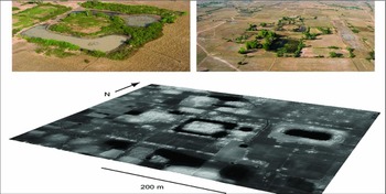
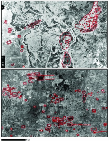
Traditional Khmer settlement was agrarian and rural in nature (Delvert Reference Delvert1961); archaeological work in southern Cambodia indicates it may have substantial time-depth (Figure 2). Four field seasons of survey by LOMAP covered 35km2 and identified three modal settlement configurations for the pre-Angkorian period. The first involved small clusters of mounds with associated ponds and moated mounds—or “moat-and-mound temple-centred” configurations (Evans Reference Evans2007: 24–26). These could be hamlets and conform to the phum (village-level) administrative, settlement and work unit found today across Cambodia (Delvert Reference Delvert1961). LOMAP also mapped large sites with multiple moated mounds or mound-and-pond complexes (which we interpreted as phum or ‘villages’). A third settlement form involved a series of dispersed moated mounds. Figure 3 illustrates examples of pre-Angkorian settlement units from the Mekong delta and Angkorian settlement units from the Tonle Sap area. All three modal forms include mounds and ponds (the modern Khmer equivalent for pond is trapeang), around which several households lived to access fresh water during the prolonged annual dry season, and which characterise rural Khmer settlement today.
Modal Khmer residential units: top left, a typical moated local temple site; top right, moated local temple site near the high-water mark of the Tonle Sap lake at Angkor, surrounded by occupation mounds; bottom, digital terrain model of a local temple surrounded by occupation mounds and ponds in the Roluos group at Angkor; derived from LiDAR data with vegetation and other non-ground elements filtered from the scene, and with brighter areas indicating higher elevation; LiDAR courtesy of KALC.

Khmer settlement patterns: top, features mapped in Preah Phkoam area (southern Cambodia, from Stark Reference Stark2006b); bottom, features mapped in the Greater Angkor region by Evans (Reference Evans2007; background data in both images is 1:25 000 scale aerial photography acquired in 1992–1993 by FINNMAP.

These early to mid-first millennium AD LOMAP settlement patterns contain features that pre-Angkorian inscriptions describe, such as residential areas, water tanks, paths/roads/causeways, groves and plantations, and moated temples (or prasat) (Jacob Reference Jacob, Smith and Watson1979: 413). Epigraphic data indicate some variability in dispersed settlement form; for example, some villages were attached to particular rulers or temples (Sahai Reference Sahai1977: 47), while others may have been more autonomous. Archaeological research in north-west Cambodia suggests settlement pattern continuity into the Angkorian period (Evans Reference Evans2007: 184).
Angkorian period urbanisation produced new settlement configurations: the orthogonal grid, and perhaps also linear settlement along rivers, canals and roads (Pottier Reference Pottier and Haendel2012). Some relatively early temples in the Angkor region (e.g. Prei Monti, Preah Ko and Bakong) are also surrounded by multiple outer enclosures, but these may have primarily served non-habitation functions. For example, the eighth- or ninth-century Bakong temple functioned as a largely monastic (not residential) complex during its primary occupation, with residential mound clusters distributed for some distance outside its moats in a low-density, dispersed pattern. Other key ninth- to mid-eleventh-century temples that may have had associated residential areas lacked ‘city’ enclosures (e.g. Bakheng, Ta Keo and Baphuon) (Pottier Reference Pottier2000, Reference Fletcher and Smith2012: 21).
Twelfth-century Angkorian kings constructed a series of temple enclosures on large-scale orthogonal grids (e.g. Gaucher Reference Gaucher, Karlström and Källén2003, Reference Gaucher2004; Pottier Reference Pottier and Haendel2012; Evans et al. Reference Evans, Fletcher, Pottier, Chevance, Soutif, Boun Suy, Sokrithy, Darith, Tina, Samnang, Cromarty, De Greef, Hanus, Bâty, Kuszinger, Shimoda and Boornazian2013). Within its moated and walled enclosure, the Angkor Wat orthogonal grid pattern divides the space into blocks, each of which are further systematically divided into mounds and depressions that functioned as ponds. Twentieth-century surface modifications to the enclosure have obscured parts of the patterning, but we estimate that the Angkor Wat enclosure contained approximately 283 mounds and 250–300 ponds. Field-based investigations during 2010 and 2013 examined the nature and time-depth of this Khmer grid-structured settlement configuration from the twelfth century onwards.
The Angkor Wat 2010 and 2013 excavations
Excavations were undertaken at Angkor Wat from June to August 2010, and from June to July 2013 in collaboration with the APSARA (Autorité pour la Protection du Site et l'Aménagement de la Région d'Angkor) Authority. The 2010 work involved ground-verifying GPS prospection patterns in the enclosure's western section (Sonnemann et al. Reference Sonnemann, O'Reilly, Rachna, Fletcher and Pottier2015: 1420). Work also focused on the less disturbed eastern enclosure and areas immediately adjacent to Angkor Wat's eastern moat, presented here as grid maps superimposed on a LiDAR digital terrain model (Figure 4). The primary research objective was to characterise the nature and dating of residential use through topographic and sketch mapping, systematic coring and stratigraphic excavations.
LiDAR image of formal grid system across Angkor Wat enclosure: top, merged digital terrain model and hillshade model; bottom, digital terrain model with overlay of the grid reference system devised by Heng Piphal; brighter areas indicate higher elevation; LiDAR courtesy of KALC.

Fieldwork
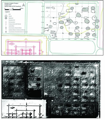
Mapping in 2010 began in the north-east quadrant with a 40 × 40m grid, which revealed a system of mounds and depressions. Few surface artefacts were visible, with the exception of a few laterite masonry fragments near unit 7. Subsequent acquisition, processing and use of LiDAR data for GAP 2013 fieldwork in the Angkor Wat enclosure confirmed this 2010 field-based mapping. The 2010 coring transects using east–west and north–south profiles of the eastern enclosure helped identify intact archaeological deposits and build an area-wide stratigraphic sequence. The 2013 coring of depressions was ground-truthing for evidence of long-term standing water that would support the classification of these depressions as ponds. Every depression visible in the LiDAR and DTM projection of the south-east quadrant was sampled.
Fieldwork also included stratigraphic excavations of 25 trenches (6 in 2010; 19 in 2013) on mounds, along mound slopes, in depressions and adjacent to walls; 11 trenches sampled the tops of mounds. In 2013, three trenches were also excavated east of the outer wall and moat, where LiDAR imagery revealed a rectangular enclosure. Figures 5 and 6 identify trench locations in the north-east and south-east quadrants within the walled enclosure, and Figure 4 identifies trench locations in this outer eastern enclosure.
Comparison of maps of the north-eastern quadrant of the Angkor Wat enclosure, from before and after the 2012 LiDAR mission (Evans et al. Reference Evans, Fletcher, Pottier, Chevance, Soutif, Boun Suy, Sokrithy, Darith, Tina, Samnang, Cromarty, De Greef, Hanus, Bâty, Kuszinger, Shimoda and Boornazian2013). Top, ground survey (courtesy of Shawn Fehrenbach), superimposed onto image (from Sonnemann et al. Reference Sonnemann, Sauerbier, Remondino, Schlotter, Campana and Forte2006). Bottom, merged digital terrain model and hillshade model derived from the 2012 LiDAR data with vegetation and other non-ground elements filtered from the scene.

Locations for all excavation trenches in eastern quadrant excavated in 2010 and 2013; grid lines identified through LiDAR are indicated in red (image courtesy of Heng Piphal).

Stratigraphy
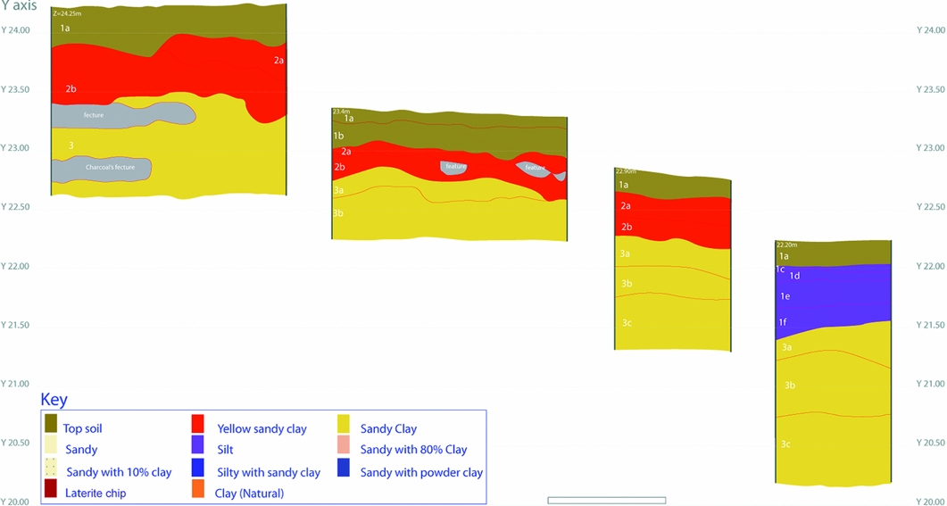
Figures 7 and 8 illustrate the four layers that characterised most trenches across the eastern enclosure. Layer 1, an organic and loamy topsoil, whose basal section contained some cultural materials; layer 2, a cultural matrix that contained ceramics (earthenware, stoneware and high-fired Chinese tradewares), some postholes, flat-lying stones or pot breaks in one or two sub-layers that represent surfaces; layer 3, a thick cultural lens of sandy clay with manganese inclusions; and layer 4, the natural substrate, which is even sandier clay. Trenches closest to the temple contained sandstone-chip construction-related debris as part of layer 2; trenches abutting the enclosure wall had the lowest artefact densities in layer 2. Layer 3 appears to represent the initial construction of the mound-pond grid structure and is associated with the temple's construction. Layer 2 is associated with the reign of Suryavarman II and use of his Vishnu temple. No pre-Angkorian signature was identified through the extensive coring and trench excavations in the eastern temple enclosure.
General stratigraphic sequence in eastern portion of Angkor Wat enclosure, illustrating layer 2 as occupational layer; layer 3 as possible construction layer (note trench 17, north wall), and pond feature in trench 24b, south wall (image courtesy of Chhay Rachna).

Photograph of trench 17 north wall.

Accordingly, layers 2 and 3 are the focus of this discussion. Layer 2 in many trenches contained charcoal flecks, ceramics and recycled architectural stone, and possibly recycled architectural ceramics. Trench 3 yielded an earthenware stove (or brazier (Cremin Reference Cremin2009: 81)) fragment. Most earthenware sherds (except a single stove fragment) derived from utilitarian vessels such as cooking pots and water jars; some sherds that showed evidence of wear or sooting were probably cooking pots. Stoneware sherds derived from jars, baluster and pedestal vases, are associated with Angkorian-period occupation and are also illustrated in the bas-reliefs of the twelfth-century Bayon temple. Khmer glazed stonewares were recovered across the Angkorian landscape, and include storage jars, boxes, bowls and bottles (Guy Reference Guy1997: 55–58; Cort Reference Cort, Cort, Farhad and Gunter2000: 98–108; Chhay et al. Reference Cremin2009, Reference Rachna, Piphal, Visoth, Klokke and Degroot2013; Ea Reference Ea2010).
Small fragments of high-fired Chinese ‘tradeware’ ceramics were also recovered during the excavations. Chinese tradewares recovered from archaeological sites across Greater Angkor date primarily from the Northern Song (AD 960–1279) through to the Ming (AD 1368–1644) dynasties (Ea Reference Ea, Pei-Kai, Li and Wan2005; Cremin Reference Cremin2006). Some particular Chinese production centres, such as the Guangdong kilns, manufacture goods that probably served as diplomatic trade products (Wong Reference Wong1979), and have been recovered in elite and non-elite contexts throughout the Angkorian realm (Wong Reference Wong2010). Lower quality Chinese bowls, boxes and globular vases are also associated with residential sites in the Angkor region (Groslier Reference Groslier1981: 230–31).
Age of the habitation deposits
Khmer people used the Angkor Wat enclosure during and after the Angkorian period. Angkor, including Angkor Wat, housed Buddhist sanctuaries that attracted pilgrims from various parts of Asia during the post-Angkorian or ‘middle Khmer’ period (Loureiro Reference Loureiro2005: 218; Sonnemann Reference Sonnemann2011: 44). One of several sixteenth- to eighteenth-century inscriptions found on walls and pillars at Angkor Wat, dating to 1579, calls the temple Visnuloka and records the restoration of the temple's walls and roof (Lewitz Reference Lewitz1972: 109). The identification of a seventeenth-century Japanese map of the Angkor Wat temple, and other post-fourteenth-century remains, underscores Angkor Wat's centrality as a religious centre for centuries after the Angkorian capital moved south-east (Thompson Reference Thompson, Jessup and Zephir1997: 28–32; Sonnemann Reference Sonnemann2011: 137–38).
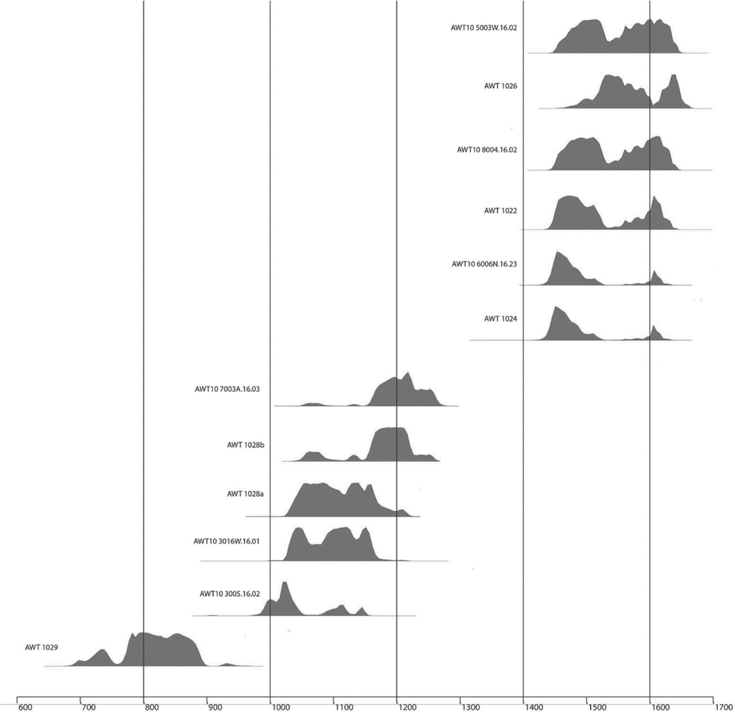
The 2010 and 2013 excavations produced both Angkorian and post-Angkorian materials in most trenches; the trenches along the enclosure's wall contained more post-Angkorian material. Two trends are clear in Figure 9, which presents radiocarbon dates from the 2010 excavations to characterise the occupation history of the Angkor Wat enclosure. First, locations near the temple and in the central north-east quadrant (i.e. unit 7) were used during the twelfth-century AD construction and initial use of the Angkor Wat temple. This pattern, coupled with LiDAR evidence for contemporaneous use of areas beyond the enclosure's eastern moat (Fletcher et al. Reference Fletcher, Evans, Pottier and Rachna2015: 1393), defines the broad area that included Angkor Wat and its environs. Secondly, post-Angkorian Khmers also lived in the enclosure, as evidenced by radiometric dates (trenches 5, 6 & 8) and the recovery of Ming period tradewares. The fifteenth-century political transformation of the Angkorian state did not therefore entail an abandonment of the Angkor Wat temple area, as often assumed (see also Brotherson Reference Brotherson2015).
Probability distributions of (2σ) calibrated radiocarbon samples from GAP excavations at Angkor Wat (courtesy of David Brotherson), with distinct phases highlighted in pale orange; left, Angkor period construction and use of the enclosure and surrounding area; right, post-Angkorian use of the enclosure from the fifteenth to eighteenth centuries).

Discussion
Angkorian Khmers laid their grid before or during the construction of the Angkor Wat temple, and this grid structured residences, and land-use, within the walled enclosure around the temple. Most sampled mounds produced archaeological evidence of residential activities such as cooking and house construction. Multiple population-modelling methods, including those using ethnographically based estimates of median Khmer house and household size (Delvert Reference Delvert1961:186), produce similar numbers; thirteenth-century Chinese reports of Angkorian Cambodia also described multi-household use of ponds (Zhou trans. Reference Zhou2007: 80; Hanus et al. in press). At its peak, the enclosure may have housed between c. 3000 and 4300 residents, and occupation at Angkor Wat continued well into the post-Angkorian period.
No significant variation was found in ceramic assemblages from different mounds to suggest social stratification; little stratigraphic variability across the cultural layers and sparse organic debris (such as faunal remains) indicates rather light habitation. This pattern contrasts markedly with deep deposits from earlier residential sites, as with the protohistoric and pre-Angkorian settlement of Angkor Borei in southern Cambodia (e.g. Stark et al. Reference Stark, Griffin, Phoeurn, Ledgerwood, Dega, Mortland, Dowling, Bayman, Sovath, Van, Chamroeun and Latinis1999; Stark Reference Stark2000; Stark & Bong Reference Stark and Bong2001). If the enclosures served largely ritual functions, then residence within their walls may have been restricted to elites (perhaps the royal court) and a range of full-time temple personnel: Brahmins and priests, temple administrators, temple attendants and support population tasked with maintenance (Coe Reference Coe1957: 410).
Alternatively, the Angkor Wat enclosure could have housed both full-time temple personnel and also temporary staff, who resided at Angkor Wat for two weeks each month in the ‘fortnight-on’, ‘fortnight-off’ pattern of work recorded in numerous Angkorian period inscriptions from smaller temples. Time is reckoned according to the waxing and waning of the moon in three separate inscriptions: K. 218 (Cœdès Reference Cœdès1937: 45–53), K. 254 (Cœdès Reference Cœdès1937: 180–93) and K. 809 (Cœdès Reference Cœdès1927: 37–46; also see Sahai Reference Sahai2012: 239–42). Working parties, if at a state temple, lived in villages outside the enclosure and alternated their use of the temple residential areas, producing a light habitation pattern. This pattern was practised at some pre-Angkorian temple complexes (described in K. 582 (Cœdès Reference Cœdès1927: 200–201), whose lodgings are labelled with a Sanskrit-Khmer compound term āvāsa kñum (Sahai Reference Sahai2012: 238).
In one scenario, only a portion of the staff lived within the Angkor Wat enclosure, either continuously or by rotation, and most staff lived elsewhere. The Angkor Wat system would then resemble that described for Ta Prohm, where only some of the 12 640 staff resided within the enclosure (e.g. Cœdès Reference Cœdès1906), which is more than six times the number of staff than residential features identified in the Ta Prohm enclosure by LiDAR survey (Evans & Fletcher Reference Evans and Fletcher2015). No twelfth-century epigraphic evidence for workgroups or enclosure use is available for the Angkor Wat temple enclosure, so the fortnightly work programmes could already have ceased by then.
GAP research indicates that residential patterning associated with Angkor Wat extends to areas beyond the temple enclosure walls to the east: excavations in 2013 produced similar stratigraphic and artefact patterning to that obtained from trenches within the temple's eastern enclosure. A series of interlocking archaeological features that cover a 35km2 area south of the temple enclosure may also be associated with residential patterning within the enclosure (Evans et al. Reference Evans, Fletcher, Pottier, Chevance, Soutif, Boun Suy, Sokrithy, Darith, Tina, Samnang, Cromarty, De Greef, Hanus, Bâty, Kuszinger, Shimoda and Boornazian2013: 2; Evans & Fletcher Reference Evans and Fletcher2015: 1411–14).
Conclusions
GAP research at Angkor Wat has produced three main findings. First, the temple enclosure area was systematically subdivided into an orthogonal grid; each ‘block’ contained a formal array of occupation mounds and ponds throughout the enclosure, except for the area flanking the western causeway from the West Gopura to the western edge of the main temple (Sonnemann et al. Reference Sonnemann, O'Reilly, Rachna, Fletcher and Pottier2015). Second, this mound-pond residential pattern, in slightly varying forms, emerged at least as early as the sixth century, and finds parallels in other pre-industrial, low-density agro-urban landscapes (Isendahl Reference Isendahl2012; Isendahl & Smith Reference Isendahl and Smith2013). Finally, light residential patterning characterises excavated portions of this orthogonal grid.
Our findings have significant implications for understanding the structure and chronology of Angkor Wat's occupation. No evidence exists for exclusive elite occupation of Angkor Wat's temple enclosure, whether political-economic or religious (priests or Brahmins). In contrast, our work supports a model in which temple personnel of modest material wealth occupied relatively insubstantial, perishable structures located on mounds in the immediate vicinity of the temple. Excavations also indicate that the Angkorian occupation occurred in three phases before the sixteenth-century Khmer royalty returned to Angkor Wat. These were: during the temple's construction phase; throughout the reign of Suryavarman II; and in the post-Angkorian period (albeit with a much reduced post-fifteenth-century population).
Our collective research suggests that the formally planned mound-pond system within the Angkor Wat enclosure did not appear sui generis, but is instead the outcome of a long-term residential logic, and its initial structure existed, in one form or another, by the sixth century and through to the eighth century AD. Even as this gradual formalisation of the structure of the built environment was taking place in Angkor from the eleventh to twelfth centuries, the antecedent pattern—of clusters of mounds and ponds scattered across the wider landscape, often centred on a local shrine (or prasat)—persisted across Greater Angkor. Use of airborne laser-scanning data, together with archaeological excavation, has allowed us to elucidate long-term patterns of continuity and change in the development of Khmer residence patterns, encompassing multiple scales from that of the broader landscape right down to the level of the individual household. It has also redefined the use of residential space within the outer enclosure of Angkor Wat.
Acknowledgements
Gracious thanks are extended to the APSARA Authority for permission to undertake field investigations in the Angkor Wat enclosure, including HE Bun Narith, HE Ros Borath and An Sopheap, which were undertaken under ARC grant DP1092663. We thank So Malay and Martin King for administrative support, and GAP 2010 and 2013 crew members, whose labour produced this research. Damian Evans drafted Figures 1–5. Martin King and Alex Morrison provided additional graphical expertise; conversations with Christophe Pottier, Roland Fletcher, Ea Darith, Ian Lowman, David Brotherson and Paul Lavy were exceptionally helpful. Thanks also to Li Baoping, John Miksic and Louise Cort for identifications of Chinese tradewares in the 2010 excavated materials. We thank the PT McElhanney, Indonesia, company for its contribution to the LiDAR acquisition, which was funded by eight institutions in the Khmer Archaeology LiDAR Consortium: APSARA Authority, the University of Sydney, l'École française d'Extrême-Orient, Société Concessionaire d'Aéroport, the Hungarian Southeast Asian Research Institute, Japan-APSARA Safeguarding Angkor, the Archaeology and Development Foundation and the World Monuments Fund. All mistakes are the responsibility of the principal author.