

Introduction
This article addresses the continuities and changes in ethnic cartography in Vienna between 1918 and 1945. It argues that the National Socialist takeover of Austria in 1938 did not lead to a fundamental change in Viennese ethnic cartography so much as to an intensification of numerous tendencies that had already been emerging. It is demonstrable that cartographers were beginning to have recourse to some works already initiated before 1938. Therefore the topic of concern is not changes in Austrian cartography, but rather the interaction of politics, scientists and map-producing institutions, as well as the resources made available to cartographers.Footnote 1 The process began with the collapse of the Habsburg monarchy in 1918–1919, continued with the appointment of the Viennese geographer Hugo Hassinger (1877–1952) to the chair of human geography at the University of Vienna in 1931, and intensified with the establishment of the South East German Research Association (Südostdeutsche Forschungsgemeinschaft, hereafter SODFG). The historian Mitchell G. Ash has confirmed a two-way process in certain scientific disciplines at this time: mutual relationships enabled scientists to mobilize resources from the political sphere for their purposes, while political institutions used scientists and their resources for their own, political ones.Footnote 2 In ethnic cartography, too, the initiatives sometimes came from scientists, who submitted maps to political institutions of their own accord, without having been constrained in any way to do so.Footnote 3
Due to the numerous ethnic groups that counted among its citizens, ethnographic maps enjoyed a long tradition in the Habsburg monarchy. The first attempts date back to the late eighteenth century, when the teacher Johann Matthias Korabinsky (1740–1811) drew his ‘Economic and ethnic map of Hungary’ in 1791, to cite just one example. At that time, ethnic maps were scarcely produced anywhere else in the world because the technical and methodical standards were not yet good enough. Fuelled by the establishment of a variety of institutions for systematic and comprehensive data capturing (e.g. in Austria the Imperial-Royal Directorate of Administrative Statistics in 1840, the Imperial-Royal Geographical Society in Vienna in 1856 and so on), the emergence of modern statistics, and the use of lithography, the fully fledged development of thematic cartography in the nineteenth century led to the intensified production of ethnographic maps. In addition, statistics were gradually rendered publicly accessible.Footnote 4 Ethnic maps were mainly produced by state institutions and a few scientists. Among these, the 1856 ‘Ethnographic map of the Austrian monarchy’ by the statistician Karl von Czoernig (1804–1889) was respected on an international scale.Footnote 5 The maps were intended to make administration easier and to prevent disputes between different ethnic groups. Furthermore, they were intended to illustrate that the different Crown lands were ethnically not homogeneous and that a separation from the Habsburg monarchy would not make sense.
In German-speaking countries, the origins of research into the history of ethnic cartography go back to the 1990s. Guntram Henrik Herb played a pioneering role in this research. His first publication on the subject was the book Under the Map of Germany,Footnote 6 in which he focused primarily on the territorial component of national self-determination, the organizational structures behind ethnographic mapping efforts, and the role of scholars at different institutions. Studies by the Austrian historian Alexander Pinwinkler should also be mentioned, in which he has given an overview of ethnographic studies by Wilhelm Winkler (1884–1984), Adolf Helbok (1883–1968) and Albrecht Penck (1858–1945), as well as of population geography during the interwar period.Footnote 7 Also worth mentioning are the publications by Michael Fahlbusch, who has published detailed studies of the six regionally oriented ethnic German research associations. The SODFG, which is very important for this study, is addressed in his main work, Wissenschaft im Dienste der nationalsozialistischen Politik, and in a number of articles, as well as in the Handbuch der völkischen Wissenschaften edited with Ingo Haar.Footnote 8 In these publications Fahlbusch also dealt with ethnic cartography during the Second World War, but laid his main focus only on the P-Stelle (the regional business office) of the SODFG without researching maps by other institutions before and after the National Socialist assumption of power in 1938.
We still do not as yet have full research results on Austrian ethnic cartography and its relationship with other scientific disciplines and politics of the 1918–1945 period. I have, however, provisionally argued that in the first half of the twentieth century almost all Austrian and German map projects were characterized by a strong political slant.Footnote 9 This article focuses on three distinct time periods in pursuit of such broader questions. The first one (1918–1919) deals with ethnic cartography at the close of the First World War and during the period of the Paris peace negotiations. In the context of this special political situation, ethnic cartography and ethnic studies experienced an unprecedented boom in Austria, with ethnic maps commissioned by public authorities. During the second, interwar period (1920–1937), it was largely scientists – from various scientific institutions – that initiated ethnic map-making. This sometimes served propagandistic and populist purposes. The third time period is the National Socialist era in Austria (1938–1945), during which ethnic maps served as an important source for the National Socialists.
Ethnic cartography at the close of the First World War and during the period of the Paris peace negotiations
In Germany as well as in Austria, the close of the First World War and the period of the peace negotiations in Paris saw an enormous boom in ethnic-geographic approaches to research and ethnic map-making.Footnote 10
In 1918 and 1919 ethnographic maps were above all produced by the Viennese publishing houses Freytag & Berndt and Artaria, as well as by various state institutions. Maps by publishing houses were mainly aimed at drawing the general public's attention to the complex ethnic problem related to the collapse of the Habsburg monarchy and the ethnic composition of the newly emerged states in South Eastern Europe. In the words of Hugo Hassinger: ‘It is the duty of every scholar to acquire in-depth knowledge of the spatial distribution of nationalities, so as not to remain uncritical and uncomprehending in the face of major political decisions’.Footnote 11 The initiatives to produce these maps came from members of the publishing houses and a few scientists (such as Hugo Hassinger). These scientists did not submit their research findings to political institutions. For the Paris peace negotiations, Austrian politicians produced their own maps without any cooperation with publishing houses. But politicians welcomed these maps, because in this way the Austrian population could be kept abreast of Europe’s political transformations. As a typical example of the many maps produced by Viennese publishing houses in 1918 and 1919, the ‘Ethnographic and linguistic map of Central Europe including Italy and the Balkan peninsula’ by Freytag & Berndt should be mentioned. The geographical distribution of the German-language population is given in pink.
Conversely, the purpose of the ethnographic maps developed by state institutions was to visualize the extension of the German-speaking settlement areas in contested border regions in order to be able to incorporate these areas into the Austrian state. The initiatives came from politicians (e.g. State Chancellor Karl Renner, 1870–1950), who produced these maps in cooperation with political and state institutions. In this context, the State Office for Foreign Affairs contacted the Central Statistical Commission and the Military-Geographical Institute with the request to jointly develop several nationality maps. During the initial phase at least, Professor Rudolf von Laun (1882–1975), a jurist at the State Office and adviser on national minority issues, and Regierungsrat Wilhelm Heck, of the Central Statistical Commission, handled coordination between the individual institutions.Footnote 12 A key role in the development of these maps was also played by Richard Engelmann, since 1 May 1912 a staff member of the Central Statistical Commission, where he discharged statistical-topographical tasks. At the time of the peace negotiations, he was mainly concerned with such studies, which were, inter alia, needed by the State Office for Foreign Affairs in connection with the precise definition of national borders.Footnote 13 The maps were classified as ‘secret’ and therefore not publicly available.
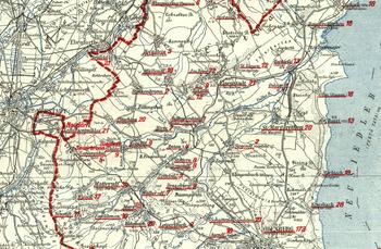
Two important maps giving a more detailed overview of the current situation regarding the various nationalities in the former Habsburg monarchy were produced in the winter of 1918–1919. Spread out over ninety-six map sheets at a scale of 1:200,000, the first one shows the linguistic minorities of the monarchy by municipalities, with the proviso that the respective language was spoken by at least a hundred persons in one municipality (Figure 1). In this, the Czech and Slovak minorities living on the territory of German Austria are given in absolute figures in violet, while the Italian minorities are shown in brown; for the rest of the former Habsburg monarchy, the German-language minorities are highlighted in red. The relative size of the minorities is stated by differently underscoring the names of the various settlements (less than 10 per cent, dotted; 10–20 per cent, dot-dashed; over 50 per cent, unbroken line).Footnote 14 The second map, also drawn at a scale of 1:200,000, is entitled ‘Styrie méridionale et Carinthie’ and presents the relative shares of German native speakers in the total populations of Lower Styria and Carinthia by means of six scaled-tone fields. The French title of the map was chosen for the peace negotiations in Paris.
A section of the map showing nationalities in the former Habsburg monarchy. Austrian National Library, Kar 543928 E.

Furthermore, the Austrian state also initiated the production of simple ethnographic maps that exclusively highlighted the German-speaking population outside Austria. But they do not show the absolute and relative shares of German native speakers, only their localization in Eastern and South Eastern Europe. These maps were bound into propagandistic booklets, for which the politicians reverted to help from outside political institutions, including the historian Alfons Dopsch (1868–1953), the historian and geographer Hans Pirchegger (1875–1973), the law historian Karl Gottfried Hugelmann (1879–1959), the historian Hans Voltelini (1862–1938), the geographer Franz Heiderich (1863–1926), the geographer Robert Sieger (1848–1923) and the folklorist Viktor von Geramb (1884–1958). For example, the propagandistic pamphlets Die Südgrenze der deutschen Steiermark (The Southern Border of German Styria) by the University of Graz and Deutschösterreich und die Nationen in den Grenzlandschaften (German Austria and the Nations near the Borderlands) by the Viennese Economic University were produced.Footnote 15 Scientists provided their scientific knowledge willingly to political institutions, but the idea was clearly exclusively initiated by Austrian politicians (in contrast to some ethnographic projects under the National Socialist regime).
During the peace talks of Paris, most of the involved states came with topographic and thematic maps, which should help to set down new borders (for example, Hungary with maps by the Hungarian geographers Zsigmond Bátky (1874–1939) and Károly Kogutowicz 1886–1948), and Serbia with maps by the Serbian geographer Jovan Cvijić (1865–1927)).Footnote 16 In Germany the geographer Albrecht Penck initiated some mapping projects in 1918 and 1919, but the ‘German government did not consider maps and geographic experts important’ for the Paris peace talks.Footnote 17 Contrary to the situation in Austria, the initiatives to produce maps came from scientists, who submitted their maps to political institutions. But the German government showed no interest.Footnote 18 The American historian Charles Seymour (1864–1926) described the importance of maps as follows:
One of the most picturesque scenes of the Conference took place in Mr. Wilson's drawing room in Paris, with the President on all fours in front of a large map on the parquet floor, other plenipotentiaries in like posture, with Orlando crawling like a bear to get a better view, as Wilson delivered a succinct and accurate lecture on the economics and physiography of the Klagenfurt Basin. Maps were everywhere.Footnote 19
But the Austrian maps and propagandistic booklets were not used during the peace talks, since no negotiations regarding the mutual protection of national minorities were undertaken between Austria and the Allies. Instead, the Austrian delegation needed nationality maps of areas in western Hungary, which had to be forwarded to Paris.Footnote 20 These maps were all created by Richard Pfaundler (1882–1959), a staff member of the Central Statistical Commission, who had drawn them around 1910.Footnote 21 The maps reflect the share of German native speakers in the total population by means of different shades of pink. These maps indeed contributed in a small way to the fact that the current federal province of Burgenland, which still belonged to the Hungarian part of the empire at the time, was ultimately allotted to the Republic of Austria.
The interwar period
After the peace negotiations of Paris, practically no further ethnographic maps were commissioned by public authorities. Throughout the 1920s, their production by publishing houses and political institutions likewise rapidly decreased. Conversely, more and more scholars dedicated themselves to ethnic map-making. Maps were produced without the initiative of Austrian politicians. The initiatives came from scientists of different scientific institutions and were produced in a context of the growing importance of geopolitical studies in Austria and Germany.
Geopolitics as a field of knowledge developed in the wake of rival colonial powers at various geographic institutions in the late nineteenth century. The main purpose was to explore geographic space in relation to political power. Especially after the First World War, geopolitical studies grew more and more important. A number of German and Austrian scientists (Otto Maull, Karl Haushofer, Erich Obst, Hermann Lautensach, Rupert von Schumacher) provided studies, which were characterized by numerous overlaps with the National Socialist expansion policy and the concept of living space (Lebensraumpolitik).Footnote 22 The cartographic approaches of geopolitical maps included a social and natural-science construction, as well as studies of military science and the German ethnic and cultural territory (Volks- und Kulturbodenforschung).Footnote 23 On many maps, the location of the German-speaking people in Europe was depicted, as in most of the ethnic maps produced between 1918 and 1945. But contrary to the ethnic maps described in this article, the real geopolitical maps were characterized ‘by a simple map image, a suggestive and propagandistic meaning and a black and white design in combination with a political perspective’.Footnote 24
One of the first to publish ethnic maps after 1919 was the Viennese statistician Wilhelm Winkler, who in 1923 was appointed head of the Institute of Statistics of Ethnic Minorities at the University of Vienna. His two maps, ‘Sprachenkarte von Mitteleuropa’ (Linguistic map of Central Europe) (1920, 1:500,000) and ‘Völker und Staaten in Mitteleuropa’ (Peoples and states in Central Europe) (1924, 1:4.000,000) render the geographical distribution of the German-language population of Europe in suggestive, visually striking, red. The intention is to foster public conviction of the existence of a homogeneous German-speaking, German-cultural space in Europe, which had allegedly been denied a common state at the Paris peace negotiations. This is, above all, expressed clearly in the texts accompanying the maps. His sources were linguistic data, collected in the Habsburg monarchy in 1910, and statistics, which he worked out for the Paris peace negotiations.Footnote 25 Winkler's maps were admitted to schools and cited in German literature as an important source of ‘ethnic-political cartography’.Footnote 26 But some other states, such as Czechoslovakia, prohibited Winkler's maps because of their political message.Footnote 27
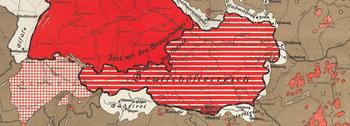
During the 1920s most ethnic maps were produced in Graz, not in Vienna. For example, the very radical ‘Heim ins Reich’ (Back to the empire) map by the geographer and historian Georg Alois Lukas (1875–?) aimed to show the desirability of uniting Austria with Germany. White was the colour used to highlight areas torn from the German Empire and withheld from Austria (e.g. South Tyrol, Lower Styria, Sudetenland). Along the German–Austrian border, the map features the slogan ‘Away with the border stones’, expressing the desire for unification with Germany (Figure 2).Footnote 28 Beginning in the second half of the 1920s, and continuing into the 1930s, this kind of propagandistic cartography was disseminated by the Austrian periodical Grenzland. Founded in 1925 and published without interruption in Graz until 1938, this periodical was mainly concerned with protecting the German-language population in and around Austria, and its cultural attainments. Each issue carried a supplement of various propagandistic maps. These maps are peculiar in that their content is much simplified and shown in black and white. Unfortunately, we are unable to pinpoint the author or authors of these maps, since as a rule no names were given. The contributors to the periodical were scholars, but also regional historians and teachers.Footnote 29 Yet these maps can be seen as real geopolitical maps, with all the characterization described above.
A section of ‘Heim ins Reich’ by Georg Alois Lukas. Library, University of Vienna I-461.424/8.

In Vienna a change came about when the cultural geographer Eugen Oberhummer (1859–1944) retired in 1931, necessitating the search for a successor to replace him at the Department of Geography. This man was Hugo Hassinger. Hassinger was born in 1877 in Vienna, the son of a bank employee. In 1896 he began his study of geography, geology and history at the University of Vienna. After his doctoral degree he worked as a teacher at different schools in Vienna and Moravia. In 1914 he was appointed lecturer at the Department of Geography at the University of Vienna. From 1918 he worked as a professor at the departments of geography at the universities of Basel (Switzerland) and Freiburg (Germany). In 1931, he returned to Vienna, where he was appointed professor of cultural geography at the University of Vienna. Hassinger died on 13 March 1952 after a road accident.Footnote 30
During his studies and during his first years as a scientist, Hassinger was involved in a scientific environment in which research on German and Slavic cultural forms, cultural boundaries and cultural stages became increasingly important at the Department of Geography. During their many excursions students were not only trained in observing nature. For the first time, questions of the influence of local geo-factors on settlement development and the emergence of cultural and political boundaries were discussed. In particular, doctoral students carried out initial research at the beginning of the twentieth century. Erwin Hanslik (1880–1940) is a good case in point. In his research, Hanslik strove to systematize the distinctive characteristics of different peoples by means of comparisons drawn from contemporary natural and cultural science.Footnote 31
Furthermore, during his teaching time in Moravian-Weisskirchen in the first decade of the twentieth century, Hassinger had also been heavily influenced by the nationality struggle between the German and the Slavic populations. He did not like the Slavic culture and thought that in the Slav-dominated schools the German child could not develop a specifically German character – that he was stunted in his education. Hassinger treated the Slavic people like second-class citizens (ascribing to them lower education, lower hygiene, bad behaviour and so on).Footnote 32 An ardent German nationalist, Hassinger regarded the peace negotiations of Versailles and Saint-Germain after the First World War as unjust. The German-speaking population was now spread across many European states, often as minorities with curtailed rights who were, moreover, to be slavicized. Hassinger turned increasingly towards the study of the German ethnic and cultural territory (Volks- und Kulturbodenforschung) and of German communities abroad (Auslandsdeutschtum).
In autumn 1931, Hassinger founded the SODFG together with other Viennese scientists such as the historian Hans Hirsch (1878–1940). It was one of six ethnic German research associations set up mainly in Germany and concerned with the systematic study of the German ethnic and cultural territory. There also existed an Alpine, West German, South East German, North East German, Overseas German and East German Research Association (after the Alpine Research Association, the SODFG was the second ethnic German research association to be founded). Their work focused on the neighbouring states of Germany, the successor states of the Austro-Hungarian monarchy and the overseas territories populated by German emigrants. Each of these research associations operated a special office (called P-Stelle), from where the regional work was centrally organized. For the SODFG, this office was located in Vienna. The members of the SODFG and also of the other ethnic German research associations were almost exclusively humanities scholars of different universities and scientific institutions. In keeping with the interdisciplinary orientation of spatial research established in the 1930s, scientists from many different fields and institutions participated in the research work. Until the end of the Second World War, they collected basic territory- and culture-related data to justify or falsify territorial claims (which were needed for the ethnic segregation of the individual population groups), planned mass relocations, and acted as consultants to SS and Wehrmacht intelligence services or other political institutions.Footnote 33
In keeping with the declared goals of the study of the German ethnic and cultural territory, the research of the SODFG focused above all on German communities abroad. These were located in the countries occupying the lands of the former Austro-Hungarian monarchy and hence in many modern-day South Eastern European states. Until 1938, the central tasks of the SODFG included the development of various directories, for example of all German and non-German scientists in South Eastern Europe and their institutes, as well as of names of settlements and the available literature on South Eastern Europe. In addition to the establishment of a library, the setting up of a translation service was particularly significant, as the press and radio channels of these South Eastern European countries were to be monitored.Footnote 34 This work was largely funded through grants towards printing and material costs and research scholarships, with the money provided by National Socialist institutions of Germany, such as the Foreign Office in Berlin, the German Research Foundation and the Association for Germans and German Culture Abroad (Verein für das Deutschtum im Ausland), an organization for the promotion of German culture.Footnote 35
The cartographic visualization of research results was very important for most of the ethnic German research associations. For example, for the SODFG the geographer Egon Lendl (1906–1989), since 1934 a scientific assistant at the Department of Geography at the University of Vienna, examined the German communities in western Slavonia and in parts of Croatia; he created some maps about the expansion of the German-speaking population.Footnote 36
The most significant ethnic maps produced by the SODFG were published in the Burgenland atlas.Footnote 37 The Burgenland atlas may safely be called the most important cartographic work produced in 1930s Vienna. A five-day Burgenland excursion of SODFG members in autumn 1933 inspired the idea to produce a regional atlas of this easternmost federal province of Austria. The initiatives came from the scientists, not from politicians or the authorities – yet they fell on fertile ground. Since the 1920s, the political authorities had had great interest in accurate scientific research into Burgenland, as this federal province had only become part of Austria in 1921. Therefore the provincial government of Burgenland supported the atlas project and made human and financial resources available for its completion. Over time, the official editors, Hugo Hassinger and Fritz Bodo (1893–1978), acquired a staff of fifty,Footnote 38 which in 1941 enabled them to produce a very complex atlas composed of 118 map sheets and fifty pages of accompanying text. Human resources could be found mainly at the University of Vienna, such as geographers (Egon Lendl, Walter Strzygowski), geologists (Hermann Vetters, Arthur Winkler-Hermaden), biologists (Wilhelm Kühnelt), historians (Otto Brunner), ethnologists (Arthur Haberlandt), German linguists (Anton Pfalz, Walter Steinhauser) and anthropologists (Viktor Lebzelter). Officials of the provincial government of Burgenland, teachers, physicians (Ernst Sedlacek, Walter Ekhart) and amateur local historians also worked for the atlas.Footnote 39
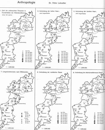
Questionnaires had been carried out by members of the provincial government of Burgenland in the years 1934, 1935 and 1936. Together with the scientists, officials collected and analysed economic, medical, demographic, social, cultural and educational data. The first questionnaires were sent out to all municipal authorities of the Burgenland in February 1934. Further questionnaires followed to hospitals, schools, Protestant and Catholic rectories and industrial concerns. The scientists’ role was to make further research in archives and libraries, carry out site inspections, create the maps and write the accompanying text. Before the 1930s, map and atlas production in Austria had not been characterized by this multidisciplinary approach. Moreover, it is quite evident that the evaluation of statistical data had been immensely stepped up for the production of this atlas compared to earlier atlas projects; likewise, the methods used to implement the project had become much more complex than in the years before 1930. As a rule, Austrian atlases dating from before 1930 do not feature combinations of various symbols and area cartograms, such as Sten de Geer's spherical method.Footnote 40 The ethnic distribution map of the Burgenland atlas shows this spherical method for the first time in Austria (the red spheres or segments symbolize Germans; the yellow, Hungarians; the grey, Croats; the green, Slovaks; and the blue, Czechs). In keeping with the then very popular ethnic and cultural territorial research, maps like the one of ‘Burgenland as part of the south-east German ethnic and state territory’ (the fields hatched in black stand for areas settled by Germans), tribal and dialect maps, and race maps by the Viennese anthropologist Viktor Lebzelter (1889–1936), were produced as well (Figure 3). The race maps of Lebzelter show, for example, the spreading of the different race types, of people with dark or light hair and eyes. Moreover, work on the historical development, the school system, the administration structure and the health care of the Burgenland was published for the first time, whereby this extensive atlas became an important source for many different scientific disciplines and institutions.
Race maps by Viktor Lebzelter. Library Department of the History University of Vienna, A III/30.

The publication of the Burgenland atlas before the National Socialist takeover failed due to financial problems caused by the economic depression and by political differences. The atlas project was greeted with some apprehension, as it established links with National Socialist Germany and several project collaborators were NSDAP members (e.g. Fritz Bodo, Walter Strzygowski, Egon Lendl, Heinrich Kunnert); this party was banned in Austria before 1938.Footnote 41 A part of the money came from National Socialist institutions of Germany. For the 1935–1936 accounting year the SODFG received 15,000 Reichsmarks,Footnote 42 and for 1936–1937 14,750 Reichsmarks.Footnote 43 It seems that most of the money was needed for the Burgenland atlas.Footnote 44 But money was also provided by the German Research Foundation.Footnote 45 Thus Austrian scientists could mobilize financial resources of the German Reich even before 1938. From 1935 onwards the provincial government of Burgenland provided neither human nor financial resources, because the connection of the SODFG with the National Socialist regime in Germany became more and more obvious. The Burgenland atlas made a significant contribution to the National Socialist concept of living space (Lebensraumpolitik) even before 1938, and may be regarded as a veiled political project. Radio transmissions and printed articles lauded the importance of the atlas as a teaching aid for schools and scholars, as well as a planning tool for a variety of public authorities. But the confidential activity reports of the SODFG, which were destined for restricted use, imply as their objective the provision of a reliable basis for warding off potential revisionist tendencies on the part of Hungary.Footnote 46
Ethnographic maps during the National Socialist era (1938–1945)
After the National Socialist takeover in March 1938, ethnographic maps were produced in the Austrian part of the German Reich (called Ostmark) by scholars belonging to various research societies and universities. As a rule, these persons were sworn to secrecy, since they had provided politicians with important data for the implementation of specific core projects. In Vienna most ethnographic maps were produced by the SODFG and the Working Group for Spatial Research of the University of Vienna.Footnote 47 During the National Socialist era, Vienna was considered a central location for the research of South Eastern Europe.Footnote 48 As a result, the ethnographic maps produced almost exclusively featured this European region. Existing networks were strengthened, new ones were established and relations to political institutions and politicians were completely redesigned.
The work of the SODFG was now more closely oriented along political lines. In addition, the Map Department was enlarged and headed by Wilfried Krallert (1912–1969), who had studied history and geography and was an NSDAP member as early as 1934. In 1934, Krallert was also accepted into the SS, where he was assigned the rank of Sturmbannführer.Footnote 49 The SODFG cooperated with Viennese scientific and public institutions, with Berlin authorities and with scientists from South Eastern Europe. Financial resources were not mobilized by the SODFG, but by Berlin authorities, which submitted the money of their own accord, without having been compelled in any way to do so. In exchange, political authorities received a great deal of knowledge about the topographic and ethnographic situation in South Eastern Europe. The initiatives to create ethnographic maps originated with politicians and the authorities and did not come from scientists.Footnote 50
After the National Socialist takeover in March 1938, the first ethnographic map was produced in 1939. This work was initiated by the Association for Germans and German Culture Abroad (Verein für das Deutschtum im Ausland). Hugo Hassinger, Walter Strzygowski (1908–1970) and a few other members of the SODFG worked out a memorandum about the resettlement of the South Tyroleans to the old German dukedoms of Auschwitz, Teschen and Zator (in today's Poland). They created a map, with the territories of the German Reich and the German minorities in red, and the areas planned for different German emigrants in yellow, orange and pink.Footnote 51
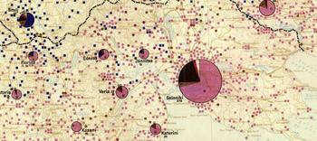
Since the beginning of the 1940s, ethnographic maps of all South Eastern European regions were produced to various scales (1:200,000; 1:1,000,000 – Figure 4) by a team headed by Wilfried Krallert in cooperation with the Department of Geography of the University of Vienna.Footnote 52 Regarding the accuracy of the thematic data visualized, these maps were certainly superior to all earlier material. In nearly all maps, the different ethnic groups were indicated in absolute figures by means of differently coloured and differently sized dots. For example, the maps at the scale of 1:200,000 visualized the absolute numbers of Germans, Slovaks, Czechs, Hungarians, Slovenes, Serbs, Albanians, Macedonians, Romanians, Bulgarians, Greeks, Russians, Ukrainians and Jews in contrast to older maps, which did not show the absolute numbers of ethnic groups. The recent maps, which were mostly commissioned by the Ministry of Foreign Affairs, proved an important source of information for the general staffs of both the army and the air force,Footnote 53 as well as for the resettlement commandos of the Ethnic Germans Welfare Office (Volksdeutsche Mittelstelle).Footnote 54 Since they also permitted conclusions regarding the geographical distribution and size of the Jewish population in South Eastern Europe, it cannot be ruled out that the ethnographic maps produced by the SODFG were specifically used as sources for the deportation and extermination of Jews.
A section of the ethnographic map of South Eastern Europe at 1:1,000,000, showing Greek areas in pink, German in red, Turkish in brown and Jewish in black. Austrian National Library, K I-121.889 K 34.

The ethnographic maps were based on existing maps, such as those used in the peace negotiations of Paris, and upon statistical material. For example, Krallert was inspired by the visualization method created by the Hungarian geographers Sigmond Bátky and Károly Kogutowicz after the First World War.Footnote 55 The SODFG received many data from scientists from South East Europe and, in cooperation with National Socialist politics, by robbery. In 1941, Wilfried Krallert participated in the looting of several companies and libraries of Belgrade in the context of Operation Künsberg. These included the Department of Geography of Belgrade University, the Statistical Office of the Ministry of the Interior and the Institute of Military Geography. In this way, Krallert captured maps and statistics which, while of great importance to the Foreign Office and the SODFG, had been partly unknown in the German Reich. All maps arrived in Vienna for further processing in late April. Inter alia, this material comprised the updated version of the map of Yugoslavia formerly unknown in Germany (scale 1:25,000), maps of the country scaled at 1:50,000 and 1:100,000, and some remaining parts of the old map of Serbia (at various scales). On behalf of the Foreign Office, the SODFG later compiled an ethnic distribution map of Yugoslavia destined only for internal official use, mostly by military authorities. It was provided to the SS and the Wehrmacht for the purpose of ethnic land consolidation.Footnote 56
After the Yugoslavian campaign, the contacts between SODFG staff members and SS special commandos continued from summer 1941 to 1944 in Russia through participation in the looting of several statistical offices and departments of geography. Moreover, Krallert issued specific orders to seize the documents of various Leningrad institutions. In 1941, Krallert took part in these raids by joining forces with the Einsatzkommando Nürnberg (Mobile Commando Nuremberg) and looting a number of institutions in Kiev, Kharkov, Odessa, Simferopol and Sevastopol, as well as, later on, in the northern Caucasus region, for strategic material. From this material, staff members of the Publication Office developed a nationalities map of the Crimea (scale 1:400,000) and an ethnographic map of the Caucasus region (scale 1:1,000,000). Inter alia, this material was used for the planned resettlement of ethnic Germans from the Volga and Black Sea regions.Footnote 57 These raids made Wilfried Krallert an expert on Yugoslav and Soviet Russian cartography.
During the National Socialist era, the Working Group for Spatial Research of the University of Vienna, which had been established in the autumn of 1938, was mainly composed of humanities scholars and natural scientists from the University of Vienna. In a 1941 lecture given in Breslau (today's Wrocław, Poland), the head of the Working Group, the geographer Hugo Hassinger, demanded a ‘reconsolidation’ of the German people:
A reconsolidation of the German people in the Danubian region is certainly in order, by which I mean an improved restructuring of the fragmented and impractically shaped linguistic enclaves. The natural, economic and social bases of all German-language enclaves must be researched in depth if the problem of designating areas for resettlement and relocation is to be solved correctly.Footnote 58
To attain this goal, Hassinger contends, Viennese scholars should provide the scientific know-how required for the resettlement of specific ethnic groups. In this, the initiatives did not always originate with politicians, but sometimes also with the scientists themselves.Footnote 59
Many cartographic studies were not commissioned from the Working Group by outside parties; rather, its director, Hassinger, initiated politically relevant projects on his own, as is documented by the resettlement maps for ethnic Germans in South Eastern Europe. After Hassinger had been commission in 1939 by the Association for Germans and German Culture Abroad to develop his first study on the resettlement of ethnic Germans,Footnote 60 he launched several initiatives in subsequent years to counteract the scattering of ‘ethnic Germans’ in South Eastern Europe. His statement in the 1941 proposal for a project on the Rearrangement of the Areas Inhabited by Ethnic Germans in the Inner Carpathian Region clearly demands that science be prepared for a time when such resettlement issues became pressing.Footnote 61 This proves that Hassinger had intended the political slant of the study from the outset, without previous requests on the part of any authority or politician. The same applies to the project on the Status Quo of Ethnic German Groups along the Middle Reaches of the Danube. In both projects, thematic maps were planned partly in cooperation with ethnic German groups in South Eastern Europe; after completion, these were to be made available not only to the Reich Working Group for Spatial Research (Reichsarbeitsgemeinschaft für Raumforschung), but also to political institutions.Footnote 62
After 1938, the Burgenland atlas was no longer funded by the SODFG, because the society now only researched Germans in the Caucasus, the Volga region and South Eastern Europe. Several letters prove that Hassinger applied instead to National Socialist politicians and authorities for printing subsidies.Footnote 63 On 13 January 1941, he requested the aid of Gau Inspector Helmut Triska (1912–1973) to ensure printing of the atlas. Triska at that time became director of Department D VIII for folk issues at the Foreign Office in Berlin and had more influence on the finances as an institutional representative. The atlas was published the same year as a result of the grants received. The Burgenland atlas was of importance for the National Socialists, above all because of its borderland research. One aspect of great interest was population analysis, as Burgenland was one of many areas proposed for the relocation of German minorities living in South Eastern Europe. This was also the reason why the atlas could only be published as an internal official document but was not made accessible to the general population during the war years.Footnote 64
During the National Socialist era, members of the Working Group for Spatial Research worked on two more atlas projects with ethnic references which were not initiated by political authorities. The initiative for the publication of the atlas of the Lower Danube Gau lay with Fritz Bodo, who in 1940 applied to the administration of the Gau for support of the atlas project. In due course, Gauhauptmann Sepp Mayer and Hugo Jury, the gauleiter of Lower Danube and Reichsstatthalter, commissioned Fritz Bodo and Hugo Hassinger to direct the work for this project.Footnote 65 This atlas was to provide a new starting point for researching the Lower Danube Gau, to assist spatial planners and to create preconditions for the redesign of the German Lebensraum for the purposes of the Third Reich. The completed atlas was to be composed of approximately 120 maps; however, its publication was not possible during the National Socialist regime.Footnote 66 A few preparatory efforts were, however, integrated into the atlas of Lower Austria published in 1951 by the Commission for Spatial Research and Reconstruction of the Austrian Academy of Sciences. Like the Burgenland atlas, this cartographic work was deliberately organized in a multidisciplinary fashion by involving numerous scientists from many different institutions and fields of study. For the preparatory work on the Gau atlas, the Working Group for Spatial Research of the University of Vienna launched some ethnic projects, such as an anthropological analysis of the population of Lower Danube by the Office of Racial Policy, as well as of the demographic age structure and population development in villages and towns from 1869 to 1930.Footnote 67 Only a few sketches of this work have remained, for example those of population development from 1869 to 1930.Footnote 68
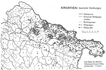
The atlas of Croatia was edited by Captain Alois Jaschke, who had mainly fought in Galicia and on the southern front during the First World War and later established a reputation through numerous scientific publications. The atlas was submitted for funding to the Reich Working Group in the 1943–1944 budget year as the Economic Basis of the Independent State of Croatia research project. It was the objective of this study to provide a general overview of Croatia's economic situation and social conditions, as well as to examine the efficiency of the Croatian economy and its controllability. The economic participation of the German ethnic groups in particular was to be highlighted. In this context, maps about the German settlements in north-eastern Croatia were produced (Figure 5). A number of letters prove that the atlas of Croatia was also compiled for the Forschungsstaffel z.b.V. special research task force, which was stationed in Neudorf am Gröditzberg.Footnote 69 During the National Socialist regime, there existed many such research task forces; they were answerable to the High Command of the Wehrmacht and charged with conducting agricultural- and forestry-related research, as well as with producing terrain maps, which might be useful for determining suitable aircraft landing points and viable passages for tanks. Forschungsstaffel z.b.V. was set up in April 1943. The unit was composed of scholars from all disciplines of the natural sciences, as well as seasoned military personnel (sappers, experts on armoured vehicles, aircraft and mountain infantry).Footnote 70 This atlas project likewise shows very clearly that the publication initiative lay with Hassinger and other scientists of the Working Group. It cannot be argued that the scientists submitted to the dictates of politics against their will. When Hassinger entered into contact with the unit, it was mainly busy with mapping parts of Dalmatia and hence found the material provided by him very useful. Due to the submission of these maps at Hassinger's behest, he was appointed to the Working Community for Military–Scientific Terrain Research and Military Geology in late 1944.Footnote 71
German settlements in north-eastern Croatia by Alois Jaschke. Archives of the University of Vienna, UAW unpublished works by Hassinger, Box 5.

The atlases of Burgenland, Croatia and the Lower Danube Gau are a good example of how initiatives leading to the promotion of scientific projects by the National Socialist state did not always originate with NS politicians, thus invalidating the assertion that the sciences were without exception ‘commandeered’ by politics. If a different approach is adopted, scientists can no longer be viewed as mere victims of National Socialism, but rather must be seen as consciously acting subjects who made their knowledge accessible to the NS regime of their own free will. Moreover, the thesis is that especially those cartographic projects which seemed most useful to the core projects of National Socialism, such as achieving the domination of Europe and creating a ‘pure-blooded master race’, were strongly championed by various authorities of the National Socialist state.
Geographers especially put all their know-how into ethnic research and politics during the period under investigation. This had to do not only with their personal political attitudes, but also, and above all, with the political orientation of the subject. While political topics in geography were already omnipresent in Germany in the nineteenth century (colonial geography by Ferdinand von Richthofen, political geography by Friedrich Ratzel, and so on), in Austria such a political orientation developed mostly as a result of a new generation of geographers at the beginning of the twentieth century. Eugen Oberhummer, Erwin Hanslik and Robert Sieger were the first who were interested in these topics. From the 1920s geopolitical and political geographical considerations were generally established in geographical research at Austrian universities. Geographers initially dealt primarily with political-geographical issues which related to the territorial changes after the end of the First World War. A thematic emphasis was placed on the new Brenner border. From the mid-1920s, political-geographical and geopolitical studies became more diverse. In addition to the studies on borders, cultural studies and research on the German ethnic and cultural territory were also established. Geography has always been a political discipline, because of its system-stabilizing and -sustaining functions dependent on current political ideologies.Footnote 72
Conclusion
The study of the development of ethnic cartography between 1918 and 1945 permits us to conclude that this process was closely related to political events surrounding the end of the First World War and during the National Socialist period. Immediately after the First World War, the specialized publishers Freytag & Berndt and Artaria & Co. developed ethnographic maps that were to convey to the public at large an understanding of the political events relating to the collapse of the Habsburg monarchy. At the peace negotiations of Saint-Germain, state institutions wanted to use ethnographic maps to justify their claims to areas with German-language majorities situated in the successor states of the Austro-Hungarian monarchy. In the 1920s and 1930s, scientists, teachers and regional historians occasionally produced radical, propagandistic maps, some of which demanded Austria's incorporation into Germany, as well as that of German-language areas in Southern and South Eastern Europe into Austria. These maps were not subject to confidentiality requirements and were tolerated by the Republic of Austria.
After the National Socialist takeover, confidential ethnographic maps of South Eastern Europe – which served as an important source for the National Socialists in their operations for ‘ethnic consolidation’ (Flurbereinigung) and their radical race theoryFootnote 73 – were above all produced by the Working Group for Spatial Research of the University of Vienna, and by the SODFG. The initiatives not only originated with politicians and the authorities, but also came from scientists themselves, who submitted their research findings to political institutions of their own accord, without having been compelled in any way to do so. But the impact of the maps did not differ systematically whether they were initiated by politicians or policy makers or by scientists. It varies more significantly by period. Politics and ethnic cartography were never separate spheres during the period under review. For example, it is not possible to distinguish Krallert’s scientific work from his political–military actions and his connections to other National Socialist authorities. But Hugo Hassinger also played a major role during the National Socialist period. Some of his statements in unpublished reports and letters show that he explicitly intended the political implications of some of his research. Hassinger was also the initiator of many politically relevant geographical projects.
Scientists from the SODFG and the Working Group for Spatial Research of the University of Vienna did not collaborate with scientists from Western European states, but with scientists from Hungary, Romania and Bulgaria. For example, a mutual exchange of statistics and maps took place between Krallert and the population statistician and anti-Semitic Sabin Manuilă (1894–1964), who headed the Romanian Central Statistical Office in Bucharest.Footnote 74 In addition, the ethnographic maps from Nazi Germany were hardly used by Western European and American scientists, since they were largely kept secret.