

Introduction
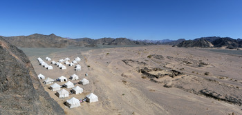
In 2020, the French Archaeological Mission to the Eastern Desert of Egypt (MAFDO) excavated a Roman fortress of the late 1st and early 2nd c. CE in the Wadi al-Ghozza (Fig. 1). This small praesidium, identified in ostraca found in the fortress as Berkou (Βɛρκου), lay along the roadways leading from the Nile to the Red Sea coast and the imperial quarries at Porphyrites and Mons Claudianus, which are in the vicinity.Footnote 1 Constructed under Vespasian, or even somewhat earlier, the fortification was occupied for a brief time and abandoned under Domitian, or perhaps as late as the early years of Trajan's reign. The fortress is remarkably well preserved and contained remnants of soldiers' activities and supplies, providing a discrete snapshot of the infrastructure and economic activities associated with the flourishing of Flavian activity in the Eastern Desert, as well as the water management infrastructure built to supply the fort's inhabitants and travelers.
General view of the site of Ghozza, looking southeast. (Courtesy G. Pollin, IFAO/MAFDO.)

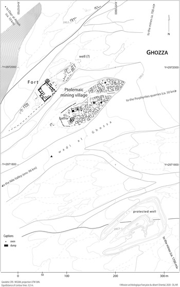
The Roman fort of Ghozza is located on a natural terrace at the edge of the northwestern bank of the Wadi al-Ghozza (Fig. 2). Over millennia, the water running seasonally in the main wadi and its north affluent formed this elongated terrace, which is about 200 m long, 40 m wide in the center, and 1.5 m above the wadi floor at its highest point, and oriented from the northeast to the southwest. The fort that occupies this northernmost terrace is not the oldest construction on the site, however. Two other terraces located just a few meters to the southeast hosted a large Ptolemaic mining village dating to the 3rd and 2nd c. BCE that was not occupied during the Roman period, and traces of Ptolemaic remains are also visible to the northeast of the praesidium and underneath the fort itself.Footnote 2 A protected well of likely Ptolemaic date is also visible to the south of the Ptolemaic village in the center of the wadi (Fig. 2).Footnote 3
Topographic plan of Ghozza after the 2020 campaign. (Courtesy D. Laisney/MAFDO.)

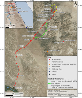
In this article, we present the results of the excavations of the Roman praesidium, including its architecture and water system, as well as the finds associated with the last phase of its occupation at the turn of the 1st c. CE.Footnote 4 This evidence – its architecture, infrastructure, and indications of daily life – provides an important complement to the materials published from Mons Claudianus and Porphyrites. These sites differ both in their specialized infrastructure – huge quarry complexes vs. a small fort – and in their duration of occupation; the two quarries were opened in the first half of the 1st c. CE (respectively under Claudius and Tiberius), and their occupation lasted several centuries after the abandonment of Ghozza.Footnote 5 However, the site of Ghozza owed its existence to these two sites, and in particular to Porphyrites, on which it seems to have depended administratively and militarily. The main access road in Roman times from Kaine (Qena),Footnote 6 in the Nile Valley, to the Porphyrites quarries is generally placed by scholars in the Wadi al-Atrash, which passes through Bab al-Mukhayniq, Dayr al-Atrash, Qattar, and the Wadi Belih (Fig. 3).Footnote 7 The work carried out in 2020 at Ghozza demonstrated that another early route to Porphyrites existed via this newly excavated Roman fort.
The site of Ghozza in the regional road network during the Principate. (Courtesy L. Manière, Desert Networks project/MAFDO.)

The primary documents and other finds recovered at the fort illuminate both the date of establishment and the function of the fort at Ghozza, as well as its place in this regional network. Accordingly, the presentation of the material and its analysis focuses first on the architecture and construction history of the fort, and associated finds, including ceramic and glass vessels, as well as metal and stone artifacts. Second, we examine the objects and texts that offer a specific historical framework and regional context for the fortification, including several ostraca and a coin recovered from abandonment levels inside the fort. We conclude with a discussion of the significance of Ghozza and its role within the regional network, as well as its historical and archaeological significance.
Architecture and stratigraphy
The pre-fort occupation: a Ptolemaic gold mining settlement
While the praesidium has a clear association with the Flavian era, the site itself has a much longer history, and indeed these earlier occupation phases were directly relevant to the choice of the site by the Roman planners. In addition to offering a convenient location for caravans traveling to Porphyrites, the site provided building materials that could be repurposed from abandoned Ptolemaic buildings, and access to a well and cistern, both almost certainly constructed in the Ptolemaic era.
This earlier occupation was discernable on the terrace where the fort was located and was contemporary with the main occupation of the mining village to the southeast. The first clues to the earlier phase appeared directly on top of the natural terrace in several locations in and around the fort (Fig. 4). In these areas, small chips of white quartz and quartz powder were plentiful. This material was not brought naturally by the floods of the wadi but resulted from the grinding of quartz blocks extracted from nearby mines by workers during the Ptolemaic period. The miners who lived in the village may have had their ore-processing stations on the north terrace that was the eventual location of the Roman fort.Footnote 8
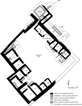
General plan of the fort of Ghozza. (B. Redon/MAFDO.)

The sizable number of stone-grinding tools found on the site supports this scenario. These included a few large rectangular and concave saddle querns, and many large semicircular rubbing stones with two small handles. These tools were everywhere on the terrace and in the fort itself. It is possible that they were brought by the Romans from the village itself, but the huge quantity of heavy stones associated with quartz processing in the fort area makes this unlikely.
These grinding stones were also used in the construction of the fort, as we will see below, but might already have been reused by Ptolemaic residents to construct floors on the terrace. Two floors paved with old handstones were found in and just outside the Roman fort at lower levels. Most of these stones lacked handles and had small circular hollow depressions in their centers, indicating that workers reused them as anvils on which they broke up the gold-bearing quartz. Pottery sherds of Ptolemaic date were found during the excavation of these two floors (SU 108.14 and 203.01–02), but that does not necessarily mean that the floors were built during the Ptolemaic period.Footnote 9 Indeed, residual Ptolemaic pottery mixed with Roman material is found all over the site, from the deepest layers of the fort to the surface. However, this type of floor made of reused anvil stones also appears in the Ptolemaic village nearby, so an earlier date is likely.
A few stratigraphic units revealed purely Ptolemaic material and could be traces of occupation before the construction of the fort. These included simple deposits not associated with any structure, such as layer 114.11 found beneath Room 114. Some built structures, such as the floor made of flat slabs and covered with a thin layer of sand and quartz chips (SU 107.06) at the bottom of Room 107, also appear to be associated with this pre-Roman phase.Footnote 10 Like the two others made of grinding stones, this floor may have been used to collect quartz dust after the grinding process, which was more easily done on a stone floor than on the natural surface of the terrace.
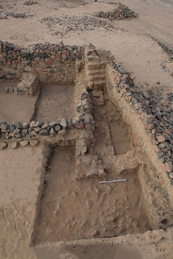
In the northwest corner of the fort, three earlier walls formed a jogged line below the curtain wall, Staircase 119, and Room 118 (Fig. 5). Their orientation was different from the rest of the standing building and their position below the fort walls suggests that this structure was also Ptolemaic, or at least predates the construction of the 1st-c. CE fort.Footnote 11 These walls (MR 100.05, 100.06, 100.07, and 118.18) form the structure called Room 120.
Area of Room 118 and Staircase 119, with the pre-fort walls of Room 120, looking west, scale 1 m. (B. Redon/MAFDO.)

General description of the fort
The fort was built after a period of abandonment of the Ptolemaic settlement, since the pottery shows that the site was no longer occupied beyond the end of the 2nd or early 1st c. BCE. The first step in the fort's construction consisted of the leveling of the terrace, which explains the spread of Ptolemaic pottery mixed with Roman material all over the site. The walls of the fort were then built directly on the compacted ground with no foundation, as is typical for Roman forts of the Eastern Desert.Footnote 12 Inside Rooms 114 and 115 extremely thick layers of ash lay on the surface of the terrace (114.09 and 115.04). These probably relate to the construction of the fort. Similarly, a large deposit of slag dumped behind the curtain wall to the southwest is also likely associated with this construction phase.
The Ghozza praesidium measures 29 m long by 25 m wide in its northern half and 31 m wide in the southern half, so approximately 827 m2. Its plan is not regular. The curtain walls delimited an almost rectangular building oriented northwest/southeast, but the southeast wing protruded to the southwest, forming an extension that interrupts the symmetry of the plan. Additionally, the north wall was not aligned with the other walls. The main gate is not preserved but was certainly located in the southeast, where violent floods destroyed the corner of the fort and eroded the terrace. The trash dump adjacent to the gate disappeared the same way, taking with it the trash produced during the early years of the building's occupation.Footnote 13 A small postern gate in the north corner gave access to an external cistern.
The fort centers on a large courtyard that was only partially excavated in 2020 (Courtyard 100). At least 15 rooms were built in one row against the curtain wall, except to the northwest, where no rooms are visible either on the surface or in the small trench excavated to the west.Footnote 14 These rooms all opened directly onto the courtyard except for Room 112, which is only accessible through Room 113. Their surface area varies from more than 20 m2 (5.05 × 4.10 m, Room 112) to 6.4 m2 (2.40 × 2.65 m, Room 110).
Fourteen of these rooms were excavated during the 2020 campaign: Rooms 102, 106, 107, and 108 against the northeast curtain wall; Rooms 109 to 116 in the south corner of the fort, a group of rooms surrounding an open area called Area 121; and Rooms 117 and 118 in the northwest. Between Room 118 and the north curtain wall, a staircase (Space 119) led to the top of the curtain wall. Considering the thinness of the curtain wall (see below), the fort probably had no parapet walk. The staircase accessed the top of the western corner of the curtain wall from which one had an overview of the route coming from the valley.
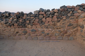
All the walls of the fort were built using dry-laid local stones, mainly pink and black granite, that were left uncut or coarsely worked. In a few sections, the walls stand to a height of 2 m. The curtain walls were between 0.70 and 1.30 m thick, whereas the inside walls were between 0.50 and 0.90 m thick. All walls were irregular and extensively reused Ptolemaic rubbing stones in their construction. These reused elements appear built into the walls at all levels, but they were sometimes used specifically as the foundation course. This is particularly visible in Room 112 (Fig. 6), but also in Rooms 113 and 116. The handles of the grinding stones were removed and used to fill small holes in the walls.
Curtain wall of Room 112, looking southwest, scale 1 m. (I. Goncalves/MAFDO.)

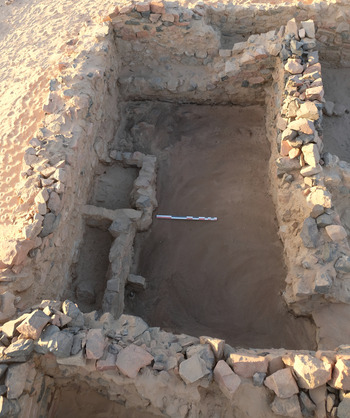
Even if the fort was built almost entirely in a single phase, various stages in that initial construction process are apparent. For example, in some places the curtain wall shows running joints between blocks of several courses or unbonded joints at the corner, which is a structural defect due to the construction of a portion of the wall that is not linked to adjacent sections.Footnote 15 This is clearly visible inside Room 118 in the upper part of the curtain wall, which precludes the possibility that this was a door that was later blocked. The southwest corner of the fort also contained a small space between the northwest wall of Room 114 and the curtain wall (Fig. 7). This narrow space, previously accessible from Room 115, was closed off for an unknown reason before the completion of the fort, as if the first design had been abandoned during the construction process.
Room 114 with its northwest wall in the background, looking northwest, scale 1 m. (I. Goncalves/MAFDO.)

Other features show that the fort's plan was modified later and not necessarily as part of the initial construction episode. In Room 106, for instance, the southwest wall simply leans against the two other walls of the room and is not bonded to them. It is also not lined up with the southwest wall of Room 107, further demonstrating that these walls were later additions to the original layout. In addition, the wall between Rooms 107 and 108 was assembled in two misaligned sections; the west one was well built and bonded to the southwest wall of Room 108, whereas the eastern part was thin and fragile. This suggests that this wall was repaired or modified at some point.
The northeast curtain wall was built using two parallel faces, probably also due to later repairs. In Rooms 102 and 106 to 108, the cleaning of the top of the walls and the collapse of several blocks of the inner cladding of the rooms revealed another wall face below the exposed one. This can only be explained as the reinforcement of an original wall with a second facing layer of stones. Since no excavation was undertaken outside the fort against the bottom of the curtain wall, the chronology of these modifications is unclear.
In the northwest corner of the fort, Staircase 119 accessed the top of the curtain wall (Fig. 8; see also Fig. 5). The first iteration of these stairs (118.05) was well built and had at least six steps. Apparently, however, a fire destroyed the wooden elements of the staircase during the occupation of the fort, since a thick layer of ash was found on the stairs and in the courtyard in front of them (118.02 and 100.02). Instead of cleaning the ashes to clear the stairs, the occupants of the fort erected new, roughly built stairs on top of them (118.04). They also placed stone benches at the bottom of the staircase. Both installations rested on the ash layer and gave easy access to the rebuilt stairs.
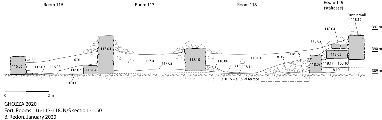
Section of Rooms 116–118. (B. Redon/MAFDO.)

Length of occupation
Aside from these minor modifications, the Roman fort of Ghozza does not show the usual evidence of elaborate transformation that most other Roman forts of the region present. Often this include the division of existing rooms, the construction of rooms in the courtyard built against this first row of rooms, and the addition of equipment, such as small silos, ovens, or benches, with no visible organization or planning.Footnote 16 The absence of these features, along with other aspects of the material recovered at the fort, demonstrates that occupation was unusually short. The Roman pottery recovered from the fort, for example, is uniformly associated with the middle and later decades of the 1st c. CE, with a small number of vessels that might indicate a Trajanic date (see discussion of pottery corpus below and Supplementary Materials).
The short duration of the fort's use life is also clear in the stratigraphy. In all the excavated rooms, the flattened surface of the terrace was sometimes covered by a thick layer of clay and served as a living surface. A few sherds of mixed date, both Ptolemaic and Early Roman, sometimes lay at this level. Just above, a single occupation layer made up of small amounts of domestic debris that related to food preparation and consumption represented the last (and perhaps also the first) important period of occupation in the rooms. Many complete or mendable cookpots, casseroles, and drinking cups appeared in these floor assemblages, and relatively few amphorae.Footnote 17 The suite of rooms along the northeast side of the fort (Rooms 102–8), for example, presented a single abandonment episode, with most rooms containing cross-mends across the excavation units above the floor, and identical groups of vessels in each room (see discussion below). A thick layer of abandonment material composed of fallen wall blocks and sand mixed with small amounts of archaeological material covered these deposits.
The only exceptions were Room 113, which acted as a vestibule for Room 112, and Rooms 111, 114, and 115. These rooms instead held middens (trash dumps) that formed during the final occupation of the fort. Many fragmentary ceramic vessels and other small objects, including both dated Domitianic ostraca (Ostraca 1–2, Fig. 27), were found spread over the entire extent of Room 113, which would have made Room 112 inaccessible. Similar trash deposits formed in other nearby rooms, apart from Room 111, which was almost empty. The pottery and glass found in the rooms surrounding Area 121 contained many cross-mending vessel fragments spread across several rooms, showing that they were being filled with debris at the same time as other parts of the fort – Rooms 102–108 – were kept clean and were likely still occupied. This paints a picture of a gradual abandonment over a relatively short period of time, since the dump fills are only 30–50 cm thick, and were likely produced quickly, given the uniformity of their contents and mends across the various strata.
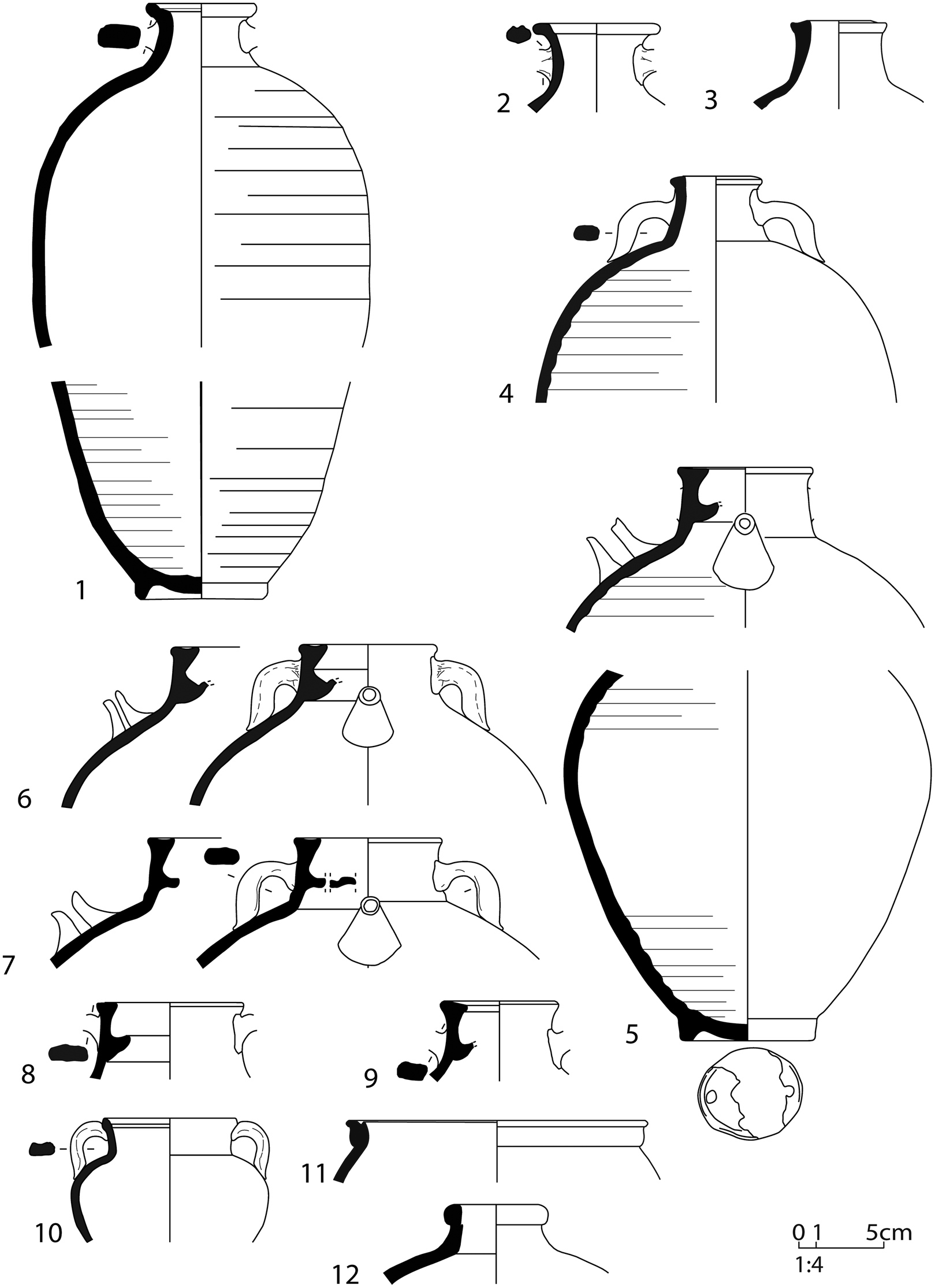
These internal dumps, like the floor assemblages from the eastern suite of rooms, are revealing, as are the contents of adjacent rooms. Room 109, for example, contained many AE3 amphorae (Figs. 20–21), suggesting that it was used as a storeroom, while Rooms 111 and 112 had very little material in them at all. The middens in the other rooms presented a mix of functional types, including many fragmentary amphorae, cooking vessels, bowls, and cups (Figs. 13–18), as well as a small number of flagons and strainer jugs (Fig. 19). The latter vessels appeared exclusively in these dump deposits and outside the praesidium near the cistern. They denoted the latest deposits (very late Flavian or early Trajanic) on the site.
Most of the vessel types found at the fort have a date range at Mons Claudianus and Porphyrites from the mid-1st c. CE into the Trajanic era. The form variants at Ghozza are most similar to the vessels contained in the 1st-c. CE deposits from the small Hydreuma at Mons Claudianus, which was thought to date from the Neronian era through the end of the Flavian period.Footnote 18 The absence of imported pottery at Ghozza makes it difficult to be more specific about the dating of the fort; even so, it is quite clear that this is a Flavian foundation – perhaps slightly earlier – abandoned in the early years of the Trajanic era at the latest, and possibly in the waning years of the Flavian dynasty.Footnote 19 The ostraca and coin finds discussed below also support a Flavian association, as does the location of the fortress in the regional network.
Installations and function of the rooms
Apart from the pottery and small objects found in the occupation layers and dump deposits, the rooms were almost devoid of installations; many did not include purpose-built features (Rooms 102, 106, 109, 111–13, 115, 117), making the function or functions of each room difficult to identify. Others had rudimentary features, such as a small square bench in the north corner of Room 107, a bench or a bed along the northwest wall of Room 116, or the two niches built into the southwest wall of Room 110, which probably served either as seats or, more likely, as shelves.
Small U-shaped fireplaces or hearths (kanun) were common and usually built outside the rooms, for obvious reasons. They were generally situated in the courtyard against the front wall of the room, not far from the door. For example, two of them lay outside Rooms 106 (SU 107.20), and 107 (SU 107.19), associated with a layer of ash (SU 107.21). Area 121 contained a concentration of five fireplaces between Rooms 111, 113, 114, 115, and 116 (SU 115.08–10, 115.13, 115.17). These, like the others in the fort, were made of flat stones arranged vertically and almost always built directly on the living surface (i.e., the alluvial terrace). The sole exception was fireplace 115.17, which sat on a small square massif of stones and was therefore slightly elevated. Inside Room 107, two saddle querns were positioned vertically against the southwest wall. They probably formed a fireplace that served not only for cooking, but also for heating the room, hence its indoor location. No ash or burned material was found in it, however.
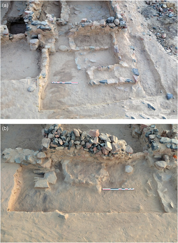
The fort also contained multiple silos, especially in the southern corner, and the ostraca recorded the existence of a granary (see Ostracon 2, Fig. 27). The silos were made of low stone walls with an empty rectangular space in the middle, and often contained archaeological fills with plentiful organic debris. Two varieties of silo were identified. The deeper type had walls of around 40 cm high. Two are preserved in Room 114 (see Figs. 2 and 7), and two in Area 121. The second type had very low walls, less than 10 cm high and formed by a single course of stones. Three rectangular (Fig. 9a) and one semicircular (Fig. 9b) example of this type were brought to light in the courtyard (100) in front of Rooms 107 and 108.Footnote 20 They, too, were filled with archaeological material – including organic remains – and may have been used as animal feeding troughs. The northern part of Room 108 contained a larger storage space separated from the rest of the room by a low wall (30 cm high). Ash and organic material filled this narrow space, unlike the rest of the room. A coin of Vespasian (Fig. 26), discussed below, lay on the top of the internal dividing wall in this room.
(a) Structures in front of Room 108, looking northeast, scale 1 m; (b) structures in front of Room 107, looking northeast, scale 1 m. (I. Goncalves/MAFDO.)

The last notable installation was found in Room 118. It consisted of a 45-cm-high platform built against the room's northwest wall and topped by an oval cavity covered with clay, where a grinding stone, now missing, was previously installed. Next to this, a low wall 70 cm long and formed of two blocks and a reused grinding stone partially closed the southern corner of the room. This platform resembled the milling installations found in Egyptian settlements of the first millennium BCE, where the grinding device was accompanied by a small, adjacent low wall forming a place to store the grain or collect the processed flour.Footnote 21
Considering all these elements, and the size and organization of the 14 excavated rooms of the fort, limited differentiation by function is possible. Room 118 was at least initially dedicated to food preparation, and Room 114 was a storage room for foodstuffs. Room 112 is the largest room of the fort and was accessed through a vestibule, making it a good candidate for the praetorium (headquarters) that was generally located in one of the corners of the Eastern Desert's Roman forts.Footnote 22 Room 116, with the bed or bench at the rear, may have been an individual room for a soldier, since it was also equipped with an oven just outside the door. Room 115, which is of the same size, as well as Rooms 108 and 107, could also have been barracks; they had similar equipment and produced similar vessels in their abandonment groups. An iron knife and a stone bowl were found in Room 107, which points to a domestic use of that space also. Rooms 109 and 110 were smaller and seem to have been storage rooms, based on the finds. However, all these functional designations must remain hypothetical, the more so since most of the forts’ rooms were probably multifunctional and accommodated a range of activities depending on the needs of the residents.Footnote 23
Water system
Most Eastern Desert forts hosted a large well in their courtyard. These have generally collapsed, but their existence is usually demonstrated by a shallow depression in the center of the praesidium. However, at Ghozza, no depression is visible in the courtyard. It has not been excavated, so the absence of an internal well is not definite, but the fort was definitely supplied with water from another well in the wadi floor located off the northeastern side of the terrace where the fort is built. This undated well has not been preserved, but large stones and pebbles extracted from the wadi during the digging of the well and now lying on the wadi surface in a rough circle around a slight depression indicate its location (see Fig. 2). According to geomorphological and topographical analysis, this position was ideal, since wells were often located at the confluence of two wadis.Footnote 24 More importantly, the construction of a long channel on the preserved terrace that starts near this point indicates the presence of a well in this location. The northeast end of the terrace has been eroded by past floods, so the connection between the well in the wadi and the channel on the terrace has been destroyed. Obviously, a lifting system must have been used, owing to the difference between the elevation of the well lower down in the wadi and the channel on the top of the terrace, but no trace of this device was recovered.
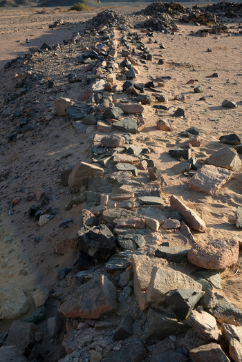
The conduit itself is clearly visible over a length of about 60 m (Fig. 10). With a slight slope of 0.75%, it conducted water from the well in the northeast to a preserved cistern located next to the fort. The end of the channel was cleared to a length of around 4 m. With a maximum width of 80 cm, it narrowed to only 30 cm at the edge of the cistern. It was made of stones covered with a hydraulic mortar, forming a narrow and shallow gutter in the middle of the channel that is about 6 cm deep and less than 10 cm wide. The gutter crossed a wall through a small tunnel to reach the tank. This wall was situated northeast of the cistern and protected it from windblown sand.
Channel with the well area in the background, looking northeast. (I. Goncalves/MAFDO.)

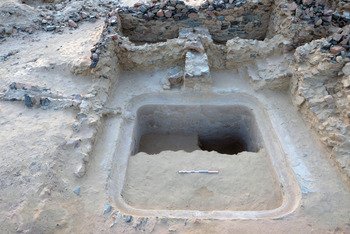
The cistern was complete and very well preserved (Fig. 11). Located directly to the north of the fort, it was accessible from the postern gate through a narrow stairway comprising three or four steps. Smooth pinkish-white hydraulic mortar lined the tank itself, which was dug into the terrace, as well as the surface around the tank. With a square plan 3.70 m wide with rounded corners and a depth of 2.60 m, the cistern had a capacity of almost 35,600 liters. A curved indention 30 cm wide and 20 cm high, the purpose of which is unknown, marked the border of the tank. After the abandonment of the fort, the walls protecting the cistern on the northeast and southwest collapsed into the cistern; windblown sand and flood debris then filled the tank.
Cistern and Room 201, looking southeast, scale 1 m. (I. Goncalves/MAFDO.)

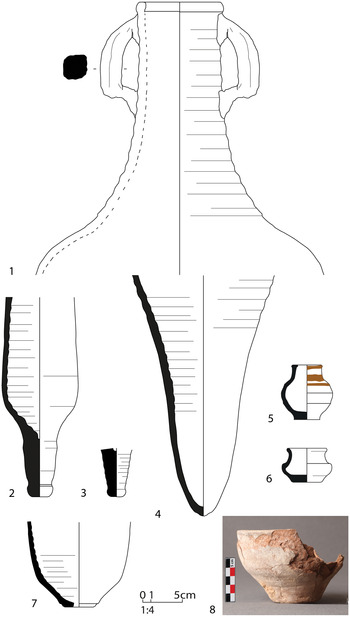
The water of the cistern was not only consumed by occupants of the fort but also by animals, as demonstrated by the presence of a long trough outside the northeast curtain wall of the fort. The connection between the cistern and the trough was an odd and complex system. At the southeastern edge of the tank, a high platform of stones was built and coated with hydraulic mortar. The upper part is damaged, so it is no longer possible to see the channel where the water was poured. The device used to draw water from the tank has likewise not survived, but several long pieces of wood were found in the cistern during the excavations and could be remains of the lifting system, likely a shaduf. This stone platform leaned against a poorly built wall, and the water channel crossed this wall through an Early Roman ribbed amphora neck (Fig. 21.1), protected by two saddle querns arranged upside down.
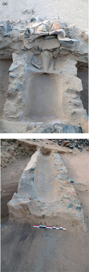
To the south of this wall was a narrow room with no door (Room 201, 1.20 m wide and 5.60 m long) built outside the fort and against the curtain wall. The beginning of the trough with its amphora-neck pipe running on a northwest/southeast axis (Fig. 12a) lay at its center. On both sides of the trough inside this small closed-off space many fragmentary Early Roman ceramics were found lying on the terrace (201.04–07). The southeast wall of Room 201 was pierced by a small tunnel that let the water run into the trough outside the room. The trough was not completely cleaned during the excavation, but only a small section beside Room 201 remained unexcavated (Fig. 12b). The structure was not built directly against the curtain wall, so animals could stand on all sides.
(a) Beginning of the drinking trough in Room 201, looking northwest; (b) drinking trough outside the fort, looking northwest, scale 0.5 m. (I. Goncalves/MAFDO.)

The trough was made of stones and completely coated inside with hydraulic mortar where the water was poured and on the exterior. Excluding the section enclosed in Room 201, the trough is 9.30 m long and 1.20 m wide. The basin is U-shaped and is 60 cm wide at the top and 40 cm deep in the middle. The floor around the trough was covered with a layer of organic material related to the presence of animals (202.07–203.02). Exterior water troughs are common in the Eastern Desert forts. They were found, for example, at the Roman forts of Dios and Didymoi, and at the Ptolemaic forts of Bi'r Samut and ‘Abbad.Footnote 25 Usually, however, they were built directly against the curtain walls.
The Ghozza fort in the typology of the Roman forts of the Eastern Desert
The fort at Ghozza is unusual in several respects when compared with the dozens of praesidia built in the Eastern Desert. As recently characterized by Reddé, in the Eastern Desert, Roman fort
plans are not standardized and no station is identical, but there are architectural similarities. The fortlets are geometric in shape and more or less regular, usually square, sometimes rectangular, with a curtain wall flanked by projecting round towers at the corners, and near the only gate; intermediary towers are sometimes known. The center of the space thus created is occupied by a large well, which is usually collapsed in on itself. The barracks are, therefore, placed against the curtain wall … The dimensions are about 50/60 m on each side.Footnote 26
The praesidium at Ghozza diverges from this description in several significant ways.
First, with a surface area of only around 800 m,2 it was very small, especially when compared with the large Roman forts built in other areas of the Eastern Desert. Most were around 3,000 m2 (Krokodilô, Maximianon, Dawwi, El-Hamra, Dayr al-Atrash), with the largest being the praesidium in the Wadi Umm Hussayn at Mons Claudianus, which had a surface area of around 5,300 m2.Footnote 27 Smaller stations are also known, such as those of Qattar, Badiya, and Bi'r Bayzah, which occupy 1,600 to 1,700 m2, but very few forts were as small as the fort of Ghozza. Smaller fortifications included El-Saqqia (475 m2), the Footpath station at the Porphyrites quarries (600 m2), the so-called Hydreuma (700 m2), which is the predecessor of the great fort mentioned above at Mons Claudianus and is dated to the first half of the 1st c. CE, the Roman station of Phalakron (Dweig; 725 m2) on the road to Berenike, and the small fort of Kalalat (700 m2) near Berenike. The Ptolemaic fort of ‘Abbad had similar dimensions (760 m2), which is, conversely, quite large in the Ptolemaic corpus of stations.Footnote 28 Except for the forts of Kalalat and Dweig, which date to the 2nd c. CE,Footnote 29 the other forts – including the fort of Ghozza – were earlier in date and their smaller size could be an Early Roman feature.
Secondly, the plan of the praesidium of Ghozza is highly irregular, which is quite rare in the corpus of Roman forts except for the odd building at Belih, and the rounded enclosure of Deir al-Wikalah.Footnote 30 There were also a few Roman forts with highly irregular plans built atop hills, but this is not the case for Ghozza's installation.Footnote 31 With these limited exceptions, other Roman praesidia were rectangular or square, with no protrusions. The placement of the well outside the fort's enclosure by some 40 m, the external cistern, and the freestanding animal trough were all highly unusual. The few known parallels include the small Roman fort at Abu Shaar al-Qibli,Footnote 32 and the very small stations of the Edfu–Berenike road, but these were smaller waystations rather than forts.Footnote 33 Indeed, this arrangement is highly illogical, since the first aim of the stations of the Eastern Desert was presumably to secure the water supply for the caravans and soldiers by enclosing a well.Footnote 34 A previous occupation of the area could explain this idiosyncrasy, with the fort reusing some ancient buildings in its construction, perhaps including the watering system.
As discussed above, a significant Ptolemaic occupation occurred on the site, mainly located on the southeastern terrace, but also on the terrace where the Roman fort was eventually built some centuries later. This terrace saw activities linked to ore processing in these earlier periods, which required a considerable supply of water. Thus, it is possible that the well to the northeast was already in use in the Ptolemaic period and supplied the processing area and the contemporary village using this same canal system and cistern.Footnote 35 Assuming that the location of the well lower in the wadi was problematic due to flooding, the Roman architects opted for an unusual compromise with an offset well and an adjacent fort on the elevated terrace, thereby following the example of the older Ptolemaic village and building atop its ruins. There is no evidence that the fort at Ghozza had a well in its center, although this is not absolutely proven; the courtyard is certainly large enough to have hosted such a device and/or internal tanks.
In addition to this peculiarity, the Ghozza fort had no tower. This recalls the layout of the small 3rd-c. CE fort of Qusur al-Banat (ca. 1,250 m2) on the Myos Hormos road, which also has no well or tower, except for two very small platforms near the gate.Footnote 36 The absence of a tower was a feature shared by many quarry forts, which differed from the road forts both through their location in the northern part of the desert and through their purpose.Footnote 37 The best example was the large praesidium of Mons Claudianus itself or the smaller fort of Umm Balad, which is a small copy of that building and dates to the 1st c. CE.Footnote 38
The absence of a tower and the small size of the fort gave to the building at Ghozza a less defensive appearance and, presumably, function. For Umm Balad and the other similar forts of the region this is usually explained by the fact that their population was composed more of civilians than soldiers, because the sites were essentially dedicated to mining and work in the nearby quarries rather than being defensive in nature.Footnote 39 However, this was not the case at Ghozza, where the main purpose of the settlement was certainly the control of the Porphyrites road (as discussed below), and the presence of soldiers is confirmed by the ostraca. Furthermore, the interiors of the quarry forts were densely occupied by partitions and rooms designed to house a large population, while the enclosure of Ghozza was comparatively empty and the garrison was limited in number.
Even though the Ghozza fort shared some characteristics with the quarry forts, therefore, it was a classic, defensive road fort and its purpose was to watch over the passage between the valley and the Porphyrites quarries, as confirmed by the ostraca. Easy access to the existing well and cistern were surely key factors in the selection of the site. As one of the first forts built in the region, it was a relatively simple complex with limited defensive character, perhaps because these qualities were deemed unnecessary at the time of its construction. The fort's irregular plan was also unusual because it incorporated older, existing architectural elements and water resources, and was built quickly with the means at hand. The short duration of its occupation, as demonstrated by the pottery, coins, and ostraca, makes it a rare example of a fort that was not transformed over time by many decades of military use and it is therefore additionally interesting as an example of a relatively unmodified Egyptian praesidium of the 1st c. CE.
Pottery
The pottery assemblage from Ghozza presents a relatively limited chronological snapshot of life in the Eastern Desert and, along with the ostraca, is the most dynamic evidence for the activities that took place at the site.Footnote 40 The pottery consists of material dating to only two phases: the 3rd to 2nd c. BCE (discussed above), and the second half of the 1st c. CE, with perhaps the very earliest years of the 2nd c. CE.Footnote 41 Comparanda for the Early Roman material are mainly drawn from locations in the Eastern Desert itself, owing to the regional specificity of these types and the availability of well-dated examples from several related sites in the region, especially Mons Claudianus and Porphyrites, which is only 29 km from Ghozza.Footnote 42 Not only do these provide a way of dating the occupation and abandonment of the fort at Ghozza, but they also offer meaningful context for the types of vessels present and the activities they supported.
The earliest deposits at Mons Claudianus date to the mid-1st c. CE, and material from the small Hydreuma, the oldest construction in the complex, provides the most relevant comparanda for identifying and dating the Ghozza assemblage.Footnote 43 At the Hydreuma, only a handful of deposits were securely dated to the 1st c. CE, but much material of the same date appeared residually in contexts dating to the Trajanic era and even later. Additionally, markers for the 1st-c. CE phase of occupation at Mons Claudianus are paralleled by surface and residual material documented at the nearby site of Porphyrites, where the earliest attested activity dates to the Tiberian era.Footnote 44
While this evidence provides good parallels for the forms and types at Ghozza, the absence of robust, well-dated, and stratified Julio-Claudian or Flavian-era deposits at either Porphyrites or Mons Claudianus means that it is difficult to distinguish between the late Julio-Claudian, Flavian, and Trajanic eras using this data on its own. Many vessel forms appear in contexts that allow for a date across these periods, particularly the Flavian and Trajanic periods; as a result, many vessel types at Mons Claudianus are dated more broadly, from the second half of the 1st c. CE into the Trajanic era. At Ghozza, however, the short-lived nature of the site's occupation, the relative uniformity of the pottery corpus, and the dates provided by associated ostraca and the single coin of Vespasian argue for a much more discrete date range in the Flavian period. This material therefore helps to refine our understanding of the pottery assemblage of the Flavian period in the desert fortresses.
This is particularly significant because it offers a concise snapshot of the pottery in use during a time of major transformation in the desert infrastructure under Flavian reorganization. The role of the army in these initiatives is well known, and indeed the fort at Ghozza was constructed, occupied, and used by the Roman military, as the ostraca make clear. Hence, the pottery assemblage provides a remarkable outline of the ‘kit’ utilized by Flavian-era soldiers, and the supply chains utilized to stock these remote outposts, which can be fruitfully compared to contemporary deposits at the port towns of Myos Hormos and Berenike, as well as Syene (Aswan) in Upper Egypt.
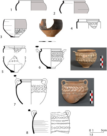
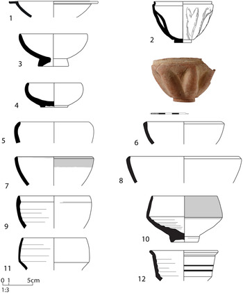
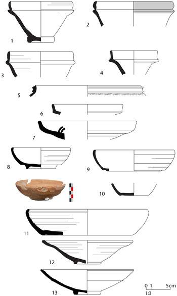
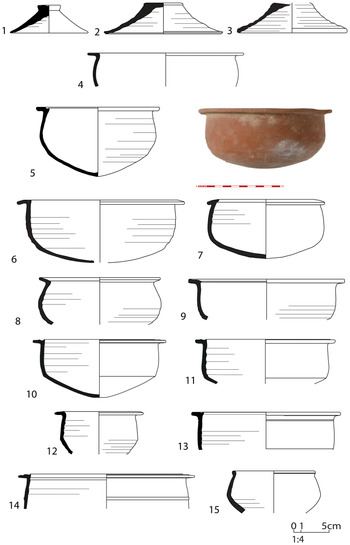
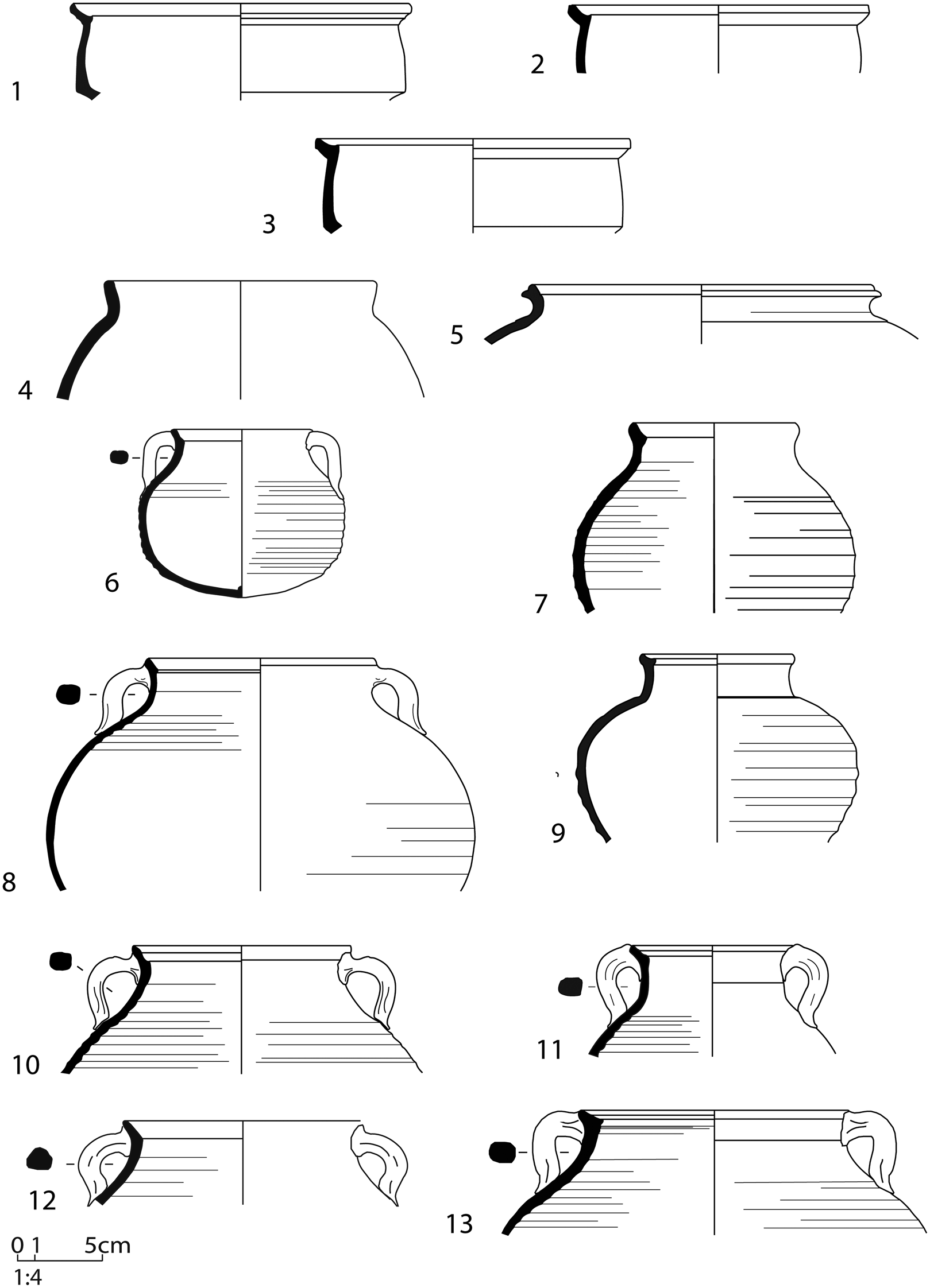
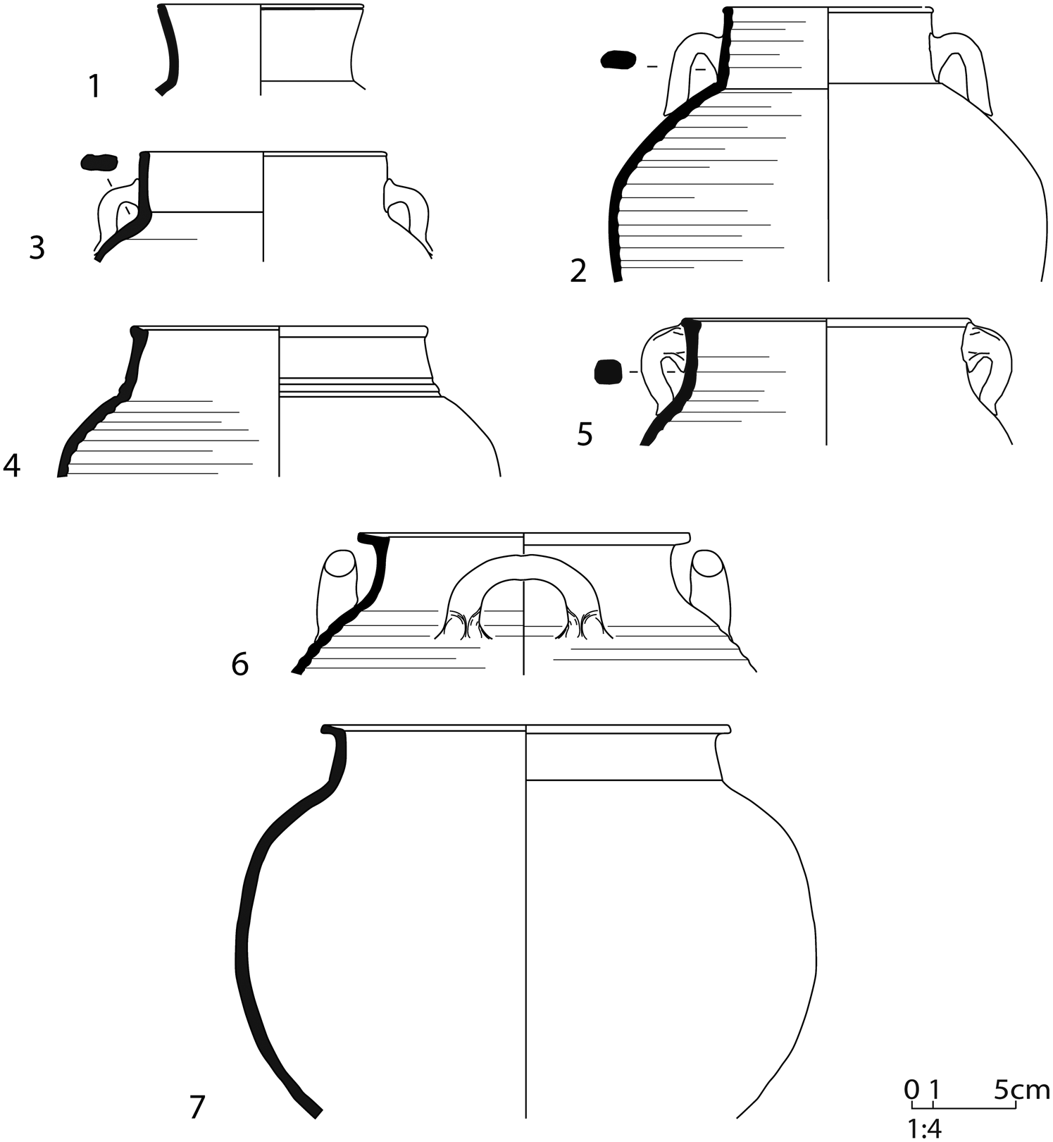
The pottery assemblage is remarkably repetitive, which again suggests that the occupation was quite limited – perhaps only 10 or 15 years. The deposit groups in the rooms without dumping activities (Rooms 102–8) present a limited number of functional types: barbotine beakers (Fig. 13.4–7), carinated bowls that imitate ESA and Cypriot sigillata (Figs. 14–15), ledge rim casseroles (Fig. 16), cookpots with either an everted or plain, tall rim (Figs. 17–18), and the occasional jar (Fig. 19) or amphora (Figs. 20–21). This group, found in proximity to cooking installations just outside the doors of these rooms or scattered on the floor, represents the remains of the daily life activities of the fort's last occupants. The paucity of amphora remains in these rooms, in comparison with the fills in the courtyard and the dump contexts on the opposite side of the fort, demonstrates a division in utilitarian space in the final episodes of the fort's life: the occupants lived in this small suite of rooms near the cistern and animal troughs, and dumped their garbage across the courtyard.
Thin-walled wares. (Drawing by M. Hepa; photos by G. Pollin. IFAO/MAFDO.)

Hemispherical and carinated bowls. (Drawing by M. Hepa; photo by G. Pollin. IFAO/MAFDO.)

Flanged bowls and dishes. (Drawing by M. Hepa; photo by G. Pollin. IFAO/MAFDO.)

Lids and casseroles. (Drawing by M. Hepa/MAFDO.)

Beveled-rim casseroles and cookpots with everted rims. (Drawing by M. Hepa. IFAO/MAFDO.)

Necked cookpots. (Drawing by M. Hepa. MAFDO.)

Flagons, strainer jugs, jars, and kegs (Drawing by M. Hepa. MAFDO.)

These vessels types are also present in the dump contexts in the suite of rooms on the western side of the fort (Rooms 109–18), but with a much higher proportion of amphorae, flagons (Fig. 19.1–4), and other storage forms. These midden deposits also contain a small number of strainer jugs (Fig. 19.5–9) that Tomber associates exclusively with the Trajanic period at Mons Claudianus. This form – a heavy-walled cylindrical jar with an internal pierced ledge at the neck – does not appear at the Hydreuma at Mons Claudianus or in the early 1st-c. CE groups at Porphyrites. Rather, an earlier variant with a simple ledge at the neck and no strainer is associated with this phase at those sites. The presence of these strainer jugs – some 10–15 vessels at most – at Ghozza suggests either that this form has its origins in the late Flavian period, slightly earlier than previously thought, or that the abandonment of Ghozza took place in the early years of the Trajanic era. Both interpretations are possible.
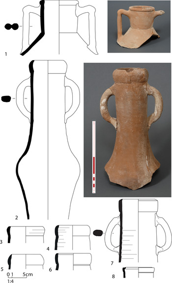
Many of the forms found at Ghozza are associated by Tomber with the Trajanic period at Mons Claudianus – barbotine beakers, for example – but the totality of the assemblage at Ghozza, which also includes many of the 1st-c. CE indicators in contexts with these ‘Trajanic’ vessels, suggests that some of these forms did indeed begin earlier than Tomber's limited evidence from the Hydreuma suggested. The morphology of the thin-walled wares, which differ in their form from the Mons Claudianus examples, also argues for an earlier date in the 1st c. CE, as do the Egyptian amphorae. These latter vessels all belong in the category of Egyptian Amphora 3 (AE3), and the rim and toe morphologies skew toward the mid to late 1st c. CE (Figs. 20–21). Imported amphorae were rare at the site and confined exclusively to the Dressel 2–4 variety, all produced in a post-79 CE fabric associated with north Campania (Fig. 20.1).
Imported and Egyptian (AE3) amphorae (Drawing by M. Hepa; photos by G. Pollin. IFAO/MAFDO.)

Egyptian ribbed amphora and AE3 toes, miniature and reworked vessels. (Drawing by M. Hepa; photos by G. Pollin and A. Bülow-Jacobsen. IFAO/MAFDO.)

The source of the vessels found at Ghozza, as indicated by their fabrics and wares, conforms to the same profile as those at Porphyrites and Mons Claudianus. The finewares and serving bowls were almost all produced in the Aswan region, while the cookwares – also remarkably uniform – are entirely in gritty, micaceous alluvial fabrics. The jars, flagons, and jugs were produced in white to cream calcareous fabric manufactured in Middle Egypt and are well documented as a marker for Early Imperial sites in the Eastern Desert. The AE3 smooth-bodied amphorae (Fig. 20.2–8; Fig. 21.2–4), which dominate, were uniformly produced in the dark brown, friable alluvial fabric described at Claudianus.Footnote 45 A single ribbed AE3 amphora (Figs. 12a and 21.1) in calcareous fabric was recovered used as a pipe in the installation south of the cistern (see discussion above). This vessel has parallels at Tebtynis in the late 1st to early 2nd c. CE, but no direct equivalent at Mons Claudianus or Porphyrites.
The pottery from Ghozza elaborates on the Eastern Desert corpus of pottery by offering a discrete, well-dated sample of forms and wares in circulation in the Flavian (and perhaps very early Trajanic) period in Egypt. Some of the forms present at this fort are also represented at Mons Claudianus and Porphyrites, but in many cases offer new variants not documented at the larger sites. Their recovery – both in stratified dump contexts in the fort with dated ostraca and abandoned in sealed-room contexts – makes this corpus an invaluable addition to our knowledge of Roman military supply and organization in the Flavian era.
Small finds
In addition to pottery, the excavations in the praesidium produced a considerable quantity of small finds; almost 200 objects were registered.Footnote 46 In general, the objects reflect the needs and activities of daily life, which is evident in the glass vessels, metal utensils, and large number of stone vessels and tools. A number of typologically variable ceramic lamps from the Roman period were also found in the fort.
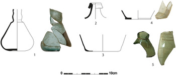
Glass vessels were found throughout the fortress and occur in quantity in rubbish deposits, especially from the domestic dumps in the southeastern rooms around Area 121. Some joins were noted between different contexts as well as in different rooms of the fort, and these are useful indicators of contemporary filling that complements the pottery evidence described above. The very fragmentary nature of the material sometimes made it impossible to precisely determine the forms represented, since only a few rims and bases were preserved. Most of the recovered fragments were body sherds.Footnote 47 The cataloged glass is clear green-blue, pale green, or colorless, sometimes with a milky tinge on the surface (Fig. 22.1–5). Some pieces were additionally decorated with horizontal incised lines.Footnote 48
Glass vessels. (Drawing by M. Hepa; photos by G. Pollin. IFAO/MAFDO.)

All the recovered fragments were associated with common glass tableware, including toilet vessels, beakers or bowls (difficult to distinguish with only body sherds), and flasks. The unguentarium (Fig. 22.1) made of green-blue glass is a common early Roman type characterized by a thick base.Footnote 49 Mending fragments of this single vessel were found in midden deposits in Courtyard 100 and Rooms 111, 114, and 115.Footnote 50 This type was popular in the second half of the 1st c. CE, particularly during the Flavian and early Trajanic eras. In Egypt, the vessel form is ubiquitous in Early Imperial contexts. Parallels have been found in Syene, Elephantine, Quseir al-Qadim, Medinet Madi (Fayum), and Tell el-Herr.Footnote 51 The vessel was probably used for medical essences or oil. Fragments of a one-handled flask (Fig. 22.2) with a flanged rim and ribbed handle are of similar date.Footnote 52 This vessel type appears at several Early Roman sites in the Eastern Desert, especially in the Flavian era.Footnote 53 Interestingly, it is rare in Egypt outside the Eastern Desert, and similar specimens can only be verified from Elephantine.Footnote 54
Some vessel bases cannot be associated with a definite shape. These include a flat base of white, milky glass (Fig. 22.3) and a base with a foot ring (Fig. 22.4), probably belonging to a beaker or bowl.Footnote 55 A few sherds were decorated with horizontal incised lines. The illustrated example (Fig. 22.5) consisted of two fragments of thin green glass that probably belonged to the same vessel, likely a flask or balsamarium.Footnote 56 The horizontal cutting lines on the body and the narrow neck-mouth are similar to fragments found in Didymoi in the Eastern Desert and at Elephantine.Footnote 57
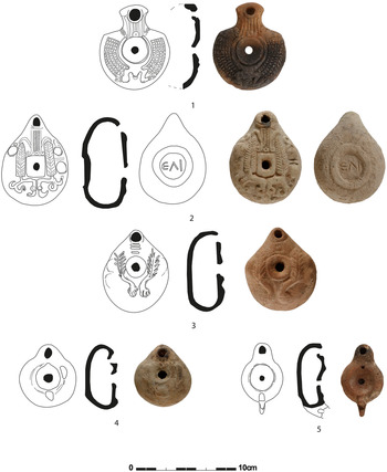
Seven completely preserved mold-made lamps, five of which are illustrated here (Fig. 23.1–5), were recovered in the fortress. All lamps are of Egyptian manufacture and the fabrics can be divided into three major groups: Nile alluvial clay, pink clay from the Aswan region,Footnote 58 and Egyptian calcareous (marl) clay, which is light-colored. Given the fabrics represented, the likely production zone for these objects is Qena, Ballas, or Esna.Footnote 59
Ceramic lamps. (Drawing by M. Hepa; photos by G. Pollin. IFAO/MAFDO.)

A Neo-Hellenistic “frog” lamp (Fig. 23.1) made of alluvial clay is among the most widely distributed types in Ptolemaic and Early Roman Egypt.Footnote 60 The round body with a slightly recessed filling hole and elongated nozzle is typical of this type. The nozzle is rectangular in shape and carries relief decoration. The date of these lamps, which are derived from Hellenistic types, falls in the Late Ptolemaic to Early Imperial period.Footnote 61 Other lamps from Ghozza belong to a type of globular lamp with a representation of palm or wheat motifs on the upper surface. These motifs are associated with the fertile Nile flood and are common in the lamps from Mons Claudianus dated to the 1st and mid-2nd c. CE.Footnote 62 The first example (Fig. 23.2) was produced in an Egyptian calcareous clay and carries a post cocturam Greek inscription on the base that contains the letters ɛλι. The inscription probably gives the owner's name; parallels are as yet unknown. A second lamp of this type (Fig. 23.3) but produced in Aswan was also recovered from the fort. A single mold-made ´Boss´ lamp (Fig. 23.4), decorated with three impressed bosses, one of which is almost entirely abraded, was found at Ghozza. Parallels for this kind of decorative Roman lamp appear in large quantities and in different varieties at Mons Claudianus and throughout Egypt during the late 1st and beginning of the 2nd c. CE.Footnote 63
The final example is a small lamp with a pierced handle made of Nile alluvium. Its shape is similar to an Egyptian Loeschcke type IX (Fig. 23.5) with a continuous discus rim, though on this example the discus rim seems to be heavily abraded with a plain outward-sloping shoulder.Footnote 64 It has a central filling hole and a pierced horizontal handle. The absence of the typical square shoulder lugs and the channel leading from the hole to the nozzle suggests that this is an Egyptian variant of this type. According to the numerous examples at Mons Claudianus and Porphyrites, a date from the end of the 1st to the beginning of the 2nd c. CE is reasonable, which is also confirmed by the overall dating of the fortress of Ghozza.Footnote 65
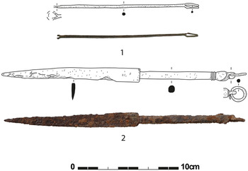
In addition to the domestic items, some metal objects (Figs. 24.1–2) found in the fort are associated with production activities. A narrow bronze utensil (Fig. 24.1) was likely used to produce nets,Footnote 66 as can be seen on grave reliefs showing fishing scenes dating to the Old Kingdom in Saqqara.Footnote 67 The netting needle has a blunt tip and the planes where the forks are located are at right angles to each other. Netting needles are attested in Naukratis, in Algeciras in Spain, and in graves dated to the Late Bronze Age in Tell el-Ajjul in the Southern Levant.Footnote 68 They were used to create the ‘knotted netting’ required for both casting nets and other objects, and for producing or repairing fishing nets. Further finds from England testify that this type of needle was also used to produce nets in the Middle Ages.Footnote 69 It is possible that this tool was employed to create netting for use in snares or other kinds of animal traps in the Eastern Desert context. Another well-preserved metal object is an iron knife (Fig. 24.2).Footnote 70 This narrow knife has an eyelet as a suspension device at its end. The knife was personal equipment, and the eyelet suggests that it was probably part of a set consisting of several tools.
Metal implements (Drawing by M. Hepa; photos by G. Pollin. IFAO/MAFDO.)

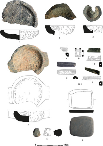
Many stone objects made from the types of stone found in the vicinity were used in domestic production at Ghozza.Footnote 71 Granite bowls (Fig. 25.1–4) in varying sizes functioned as storage vessels or mortars (Fig. 25.4). The large stone bowl (Fig. 25.4) was found together with the iron knife (Fig. 24.2) on the occupation level of Room 107, for example. The soapstone pounding stone (Fig. 25.5) was probably used in food production activities such as the pounding of wheat or herbs.Footnote 72 Some of these items were unfinished (Fig. 25.3), and mortars made from granite, granodiorite, soapstone, or sandstone were sometimes damaged during production or use. Many appeared discarded in the fort or reused as building materials.
Stone vessels, objects, and tools. (Drawing by M. Hepa; photos by G. Pollin. IFAO.)

Several small, elongated soapstone objects were found in the dumps inside the fortress (Fig. 25.6a–e) and are of particular interest. These objects are worked on the outside and have a hole drilled through their center; sometimes the object is completely pierced (Fig. 25.6a, c, e) and in some cases the hole is incomplete (Fig. 25.6d). All of them are fragmentary, so the function of the objects is unclear; the only known parallels from outside the Eastern Desert come from Qantir/Pi-Ramesses.Footnote 73 Similar objects in worked bone or wood have been found in other Roman forts in the Eastern Desert and have been interpreted as handles for a needle or an awl, which is also possible for the Ghozza finds.Footnote 74 Finally, a small rectangular palette (Fig. 25.7) was commonly used in Roman Egypt to produce cosmetic or medical substances, and several have been found at different sites in the desert.Footnote 75 In the fortress of Ghozza this object is made from soapstone and shows traces of wear on the surface. It probably belongs to a group of personal items used by residents of the fort.
Numismatic and textual evidence
Five copper-alloy coins were unearthed at the site of Ghozza in 2020. Four of them were Ptolemaic coins from the 3rd c. BCE associated with the earlier phase of occupation at the site and found in the mining village to the southeast. The only coin found in the Roman fort was a bronze coin of Vespasian found in Room 108 (SU 108.09, see above).
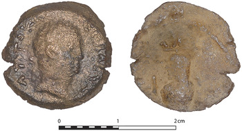
The year 10, visible on the left side on the reverse of the coin gives the date of minting: the 10th year of the reign of Vespasian, 77/78 CE. The coin would not in itself be a remarkable find, but its location and the resulting implications for the fort's date of establishment and usage make it significant, as does the fact that this type seems to be unique.
The coin is worn but its designs are clearly visible. On the obverse, the laureate head of Vespasian is easy to distinguish, as is much of the first part of the legend, ΑΥΤΟΚ, on the left side of the coin. This leaves little doubt as to the identification of the emperor. The legend is certainly ΑΥΤΟΚ ΚΑΙΣ ΣΕΒΑ ΟΥΕΣΠΑΣΙΑΝΟΥ, even if the letters after ΑΥΤΟΚ are not decipherable. It could also be ΑΥΤΟΚ ΚΑΙΣΑΡΟΣ ΟΥΕΣΠΑΣΙΑΝΟΥ, but the first option is preferable, as it is the legend used in all the coins of Vespasian depicting a Canopic jar on the reverse.
The Canopic jar reverse is common, but the fact that the jar is facing left is unusual. This orientation is found on only a few other specimens out of about a hundred issues, including a small coin of 12 mm struck in the 11th year of Hadrian, a diobol of Antoninus Pius, and several coins showing Faustina on the obverse. In addition, the coin shows what must be the year 10 on the left field. Only the I is visible but the possibility that it could be a mark of value rather than a date is slim.Footnote 76 To our knowledge, there was only one other coin struck in Alexandria in the 10th year of Vespasian.Footnote 77
As mentioned above, a series of fortresses in the Eastern Desert were built under Vespasian in the year 76/77 CE.Footnote 78 It is likely that large batches of coins reached the Eastern Desert with soldiers at that precise moment and continued to circulate for some time.Footnote 79 Although diobols (of about 24 mm) are the most common coins found in the fortresses, the obol (the denomination of this coin) is also well represented in these contexts. Since this is the only specimen found in the praesidium of Ghozza, it cannot reveal anything about the broader monetary economy of the site, but it does suggest that it was potentially part of the Flavian reorganization and exploitation of the Eastern Desert infrastructure, if not actually founded under Vespasian.
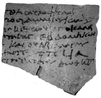
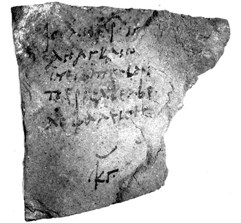
The Flavian date suggested by this unique coin is further supported by the ostraca. The praesidium at Ghozza yielded only 46 ostraca (O.Berkou) owing to the fact that its outer midden was washed away by floods. However, two of these carried a date and several mentioned local place names, including the likely name of the praesidium itself, Berkou.Footnote 80 The two dated ostraca, Ostraca 1–2 (Fig. 27), are from the month of Thoth of years 10 and 11 of Domitian (90 and 91 CE) during the term of office of the prefect of Egypt Mettius Rufus (88–92 CE), who was very active in the Eastern Desert.
Copper-alloy coin of Vespasian. Obverse: laureate head of Vespasian right, ΑΥΤΟΚ [ΚΑΙΣ ΣΕΒΑ ΟΥΕΣΠΑΣΙΑΝΟΥ]. Reverse: Canopic jar facing left, LI. Obol; diam 18 mm; 4.04 gm. (Courtesy of G. Pollin, IFAO/MAFDO.)

Ostracon 2. (Courtesy of A. Bülow-Jacobsen, MAFDO.)

Mettius Rufus had the Koptos Tariff engraved,Footnote 81 ordered the building of a new cistern at Didymoi,Footnote 82 and was probably instrumental in the opening of the metallon at Umm Balad, founded under Domitian, since the name of the prefect has been erased in the fragmentary dedication of the praesidium there; Mettius Rufus is the only prefect of Egypt who is securely known to have been subjected to damnatio memoriae.Footnote 83 Umm Balad is situated ca. 36 km northeast from Ghozza as the crow flies (Fig. 3). It was excavated in 2002 and 2003 by the MAFDO but, although the praesidium yielded ca. 1,300 ostraca, there is still some hesitation about its name, since it seems to have been called Domitiane and Kaine Latomia at the same time without distinction.Footnote 84 For that reason, we refer to it here as Umm Balad.
The likely name of the praesidium, Βɛρκου, appears on six of the ostraca in the Ghozza corpus, Ostraca 3–8 (Fig. 28, Suppl. Figs. 2–6). This name is reminiscent of the village-name Βɛρκυ in the Oxyrhynchite nome and is presumably Egyptian, but it is too short to attempt a guess at its etymology.Footnote 85 It was possibly the name of the Ptolemaic village, which is not yet evident in the Ptolemaic ostraca from Ghozza. Interestingly, Berkou is not part of the recurrent placenames in the ostraca corpus of Umm Balad; it occurs only in O.KaLa. inv. no. 847 (see discussion of Ostraca 10). Conversely, there is no mention of Domitiane or Kaine Latomia in the O.Berkou, but the ostraca from both Ghozza and Umm Balad regularly mention another placename, Sabelbi (Ostraca 9–10).Footnote 86 Apart, from Domitiane and Kaine Latomia (the presumed ancient names of Umm Balad itself), Sabelbi is the most frequently attested toponym in the O.KaLa., along with another location, Prasou.
Ostracon 3. (Courtesy of A. Bülow-Jacobsen, MAFDO.)

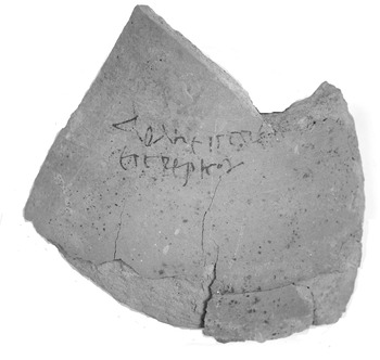
Given this pattern, Sabelbi and Prasou (see Fig. 3) must have been the names of the two road stations nearest to Umm Balad, known today as Qattar (to the southwest) and Badiya (to the northeast and closest to Porphyrites). The O.KaLa. did not, however, contain conclusive evidence that related the two names to one or the other site. Badiya was excavated in 1996–98 by a British team directed by David Peacock and Valerie Maxfield, but yielded few ostraca. Qattar has never been excavated. Now, the relatively frequent mentions of Sabelbi (Fig. 29) in the smallish corpus of newly discovered ostraca from Berkou, which incidentally contain no mention of Prasou, suggest that Sabelbi should be identified with Qattar and, consequently, Prasou with Badiya.Footnote 87 A direct route connected Berkou and Sabelbi (Qattar) in antiquity, which probably explains the mentions of Sabelbi in the fort at Ghozza. This route passed the small Roman metallon of Umm Shejilat and well of Bi'r Umm Disi (see Fig. 3) before proceeding northeast.Footnote 88
Ostracon 10. (Courtesy of A. Bülow-Jacobsen, MAFDO.)

Conclusion
The praesidium at Ghozza, which we identify as the ancient site of Berkou, dates to the Flavian period, shortly after the time when the porphyry quarries were first exploited.Footnote 89 It was abandoned quickly, however, probably by the end of the 1st or early 2nd c. CE, while the peak of porphyry exploitation was only reached later in the 2nd c. CE, under the Antonine emperors. It thus appears that the initial route from Qena in the Nile Valley to Porphyrites was opened in the 1st c. CE and included a branch that passed through the Wadi al-Ghozza as early as the late Julio-Claudian or early Flavian eras.
The temporal relationship between this roadway leading to Ghozza and the more direct route from Kaine (Qena) to Porphyrites via the fort at Dayr al-Atrash remains, however, somewhat obscure.Footnote 90 Was the Wadi al-Ghozza track the earlier of the two or were they contemporary, at least for a time? An installation of some kind already existed at Dayr al-Atrash in the Flavian period, when Berkou was in use, since an ostracon from the Dayr al-Atrash dump mentions Berkou.Footnote 91 The first season of excavations at Dayr al-Atrash in January 2020 yielded only two tituli with shipping addresses: Porphyrites and Berkou (O.Atrash inv. no. 24). The duration of this overlap is difficult to estimate, but it was probably only a few years at most, given the short life of the fortress at Ghozza.
The road network model created by the Desert Networks project that articulated the desert tracks suitable for camel traffic in antiquity confirms that the Ghozza track was a viable caravan route to the quarries.Footnote 92 After reaching the fort, this track passed through the wadi of the same name and turned left into the Khirim Ijayd valley before reaching the fort of Sabelbi (Qattar) and rejoining what later became the primary road from Qena to Porphyrites. Along the way, caravans using the Ghozza branch passed the quarries of Umm Shejilat to the east – a little off the road, 3.5 km to the east of the juncture of the Wadi al-Ghozza and the Khirim Ijayd – and the natural water source of Qalt Umm Disi located 1.8 km to the east of the road.Footnote 93 In total, the itinerary from Bab al-Mukhayniq, where the two roads separate, to the main fort of the Porphyrites quarries is 60 km via Dayr al-Atrash, and 69 km via Ghozza.Footnote 94
The initial route probably passed via Ghozza because the site was long known to desert travelers, owing to its much older occupation history and water resources. The Ptolemaic well that was eventually incorporated into the Roman infrastructure may still have been functioning. However, when this route proved too complicated to cross for the heavily loaded wagons carrying porphyry, and when it became clear that the Wadi al-Atrash was easier to traverse and shorter, the alternative route took precedence, leading to the abandonment of the praesidium at Ghozza. The Wadi al-Atrash road follows almost exactly the least-cost path reconstructed by the Desert Networks model, highlighting the ability of Romans engineers to find the shortest route.
At Ghozza, the gradual abandonment of the fortress is abundantly clear, since suites of rooms were repurposed as dumping spaces and a small number of final occupants confined their activities to the rooms adjacent to the cistern and the postern gate. These quarters were occupied until the decisive abandonment of the structure, when the last occupants left behind their cooking vessels and drinking cups, along with personal items and tools. No pottery postdating the early Trajanic period has been recovered at the site, even around the cistern or well, where available water might have attracted interest even after the cessation of the fort's official role in the Roman road network. This abrupt end suggests that the fort's raison d’être was entirely tied to the military networks guarding the Porphyrites road and that, once this shift occurred, the praesidium was summarily abandoned and traffic fully diverted to Dayr al-Atrash, where there is abundant evidence for activity in the 2nd c. CE and later.
Taken together, the materials recovered from the Early Roman praesidium at Ghozza offer important new information about the evolving organization of the stone extraction industries of the Eastern Desert and their associated infrastructure during the Principate. The fort's establishment on the ruins of a Ptolemaic settlement demonstrates that Roman planners were aware of older communities and resources and, when feasible, organized their planning to take advantage of this infrastructure, even when it required the adoption of unorthodox architectural arrangements. Even more interesting, the abandonment of the fort just as the extraction industries at nearby Porphyrites intensified suggests that Roman engineers were in a constant process of evaluating the efficiency of their transportation and security arrangements. This new evidence offers an unparalleled window into the logistics of Early Imperial military installations and their spatial organization in the Eastern Empire, as well as the place of Berkou in the local Egyptian network.
Acknowledgments
The MAFDO is directed by Thomas Faucher. It is supported by the French Ministry of Foreign Affairs and the Institut Français d'Archéologie Orientale, and works with the agreement of the Egyptian Ministry of Antiquities and Tourism. The mission is also sponsored by the European Research Council (ERC) project Desert Networks, which has received funding from the ERC under the European Union's Horizon 2020 research and innovation program (grant agreement no. 759078). The mission thanks the Ministry of Tourism and Antiquities of Egypt for its support.
Supplementary Materials
The Supplementary Materials contain a full catalog of the pottery from Ghozza, a representative catalog of the small finds, and a catalog of the ostraca, with figures of Ostraca nos. 1 and 4–9. To view the Supplementary Materials for this article, please visit https://doi.org/10.1017/S1047759421000337.
Abbreviations
- I.Did.
Greek and Latin inscriptions published in H. Cuvigny, ed. 2012. Didymoi. Une garnison romaine dans le désert Oriental d'Égypte II, 39–56. Cairo: IFAO.
- I.Portes
Bernand, A. 1984. Les portes du désert. Paris: CNRS.
- OnomThrac
Dana, D. 2014. Onomasticon Thracicum (OnomThrac). Répertoire des noms indigènes de Thrace, Macédoine Orientale, Mésies, Dacie et Bithynie. Athens: Centre de recherche de l'antiquité grecque et romaine.
- RPC II
Burnett, A., M. Amandry, and I. Carradice. 1999. Roman Provincial Coinage: Vol. II, London: British Museum Press.