

The ballgame was prominent in most Mesoamerican centers. Its importance transcends its religious symbolism as an institution that mediated social and political relationships, as shown in the regional distribution of courts in relation to settlement hierarchies (see Scarborough and Wilcox Reference Scarborough and Wilcox1991). In contrast to regional studies, in this article we examine spatial patterning within urban epicenters. Two intrasite spatial parameters contribute to understanding the role of the Mesoamerican ballgame: access and visibility (Smith Reference Smith2007:23–25).
Access refers to the degree of ease (or restriction) to reach the ballgame within its formally constructed architectural space and addresses the centrality of ball courts and their position relative to other publically accessible areas (e.g., plazas). A pioneering study by Hammond (Reference Hammond and Clarke1972:769) used graph theoretic connections among plazas and buildings at the lowland Maya site of Lubaantún to reveal that the ball court was relatively isolated and inaccessible. In contrast, most Mesoamerican ball courts (including the Gulf lowlands) were built near the central plaza, indicating their easy accessibility in an obvious way.
Visibility in our study refers to direct observation of the game regardless of the physical location of the observer within or outside the court itself. One may be able to see the ballgame clearly at a distance but be excluded for social or political reasons from ascending the mounds flanking the court, from where we assume prominent individuals watched. The ballgame simultaneously united populations, providing an event of public interest, and divided social groups based on privilege. This observation anticipates our broader findings from a formal analysis of game visibility.
Moore (Reference Moore1996a, Reference Moore1996b, Reference Moore2005) pioneered an approach to determining capacities and visibilities for Andean public plazas and monumental architecture. Subsequently, several investigators have concentrated on Mesoamerican plaza capacities to understand ceremonial or civic visibilities (Inomata Reference Inomata2006; Tsukamoto and Inomata Reference Tsukamoto and Inomata2014). Mesoamerican monumental platforms supported buildings well above the plazas, allowing people to look up and witness processions ascending stairs or ceremonies in front of temples. In contrast, architectural ball courts have flanking platforms that reduce visibility. Additionally, crowd clustering around the courts would impede the vision of those standing behind. For example, our analysis indicates that maximum potential viewers at ball courts ranged from 323 to 2,869 people, depending on the measurement method and the particular built environment surrounding the ball court.
Measuring access and visibility of the ballgame reveals whether it was designed for the public or restricted to certain social segments. These deductions may reveal strategies of social integration (i.e., inclusive vs. exclusive; e.g., Blanton and Fargher Reference Blanton and Fargher2008; Blanton et al. Reference Blanton, Feinman, Kowalewski and Peregrine1996) and relate to modes of governance: more abundant facilities or better access with stronger collective action, or more limited access with autocratic rule that was not heavily reliant on taxpayers for revenue (Blanton and Fargher Reference Blanton and Fargher2008). Our work also contributes to investigations of open space in settlements (Smith Reference Smith2008; Stanley et al. Reference Stanley, Stark, Johnston and Smith2012; Stark Reference Stark, Creekmore and Fisher2014a, Reference Stark2014c) and access to facilities that provide public benefit (e.g., Stanley et al. Reference Stanley, Dennehy, Smith, Stark, York, Cowgill, Novic and Ek2016).
We calculate viewership of ballgames in the Gulf lowlands that were played on formal, architecturally constructed courts (henceforth architectural courts) used during the Classic period (AD 300–900). We then compare game viewing to the number of people accommodated in the main plazas to assess the relative degree to which viewing a game was open to the public. Main public plazas were formal public assembly spaces typically designed to accommodate large crowds. Plaza capacities, which can be measured precisely and consistently, provide an upper limit to the quantification of public inclusiveness at any site and a way for us to normalize the viewership of the ballgame across settlements of differing sizes.
The game operated on several social levels, not all of them confined to architectural courts. We distinguish viewership from the audience; namely, the totality of people who may have heard or seen parts of the game or associated activities, perhaps processions to the court or gambling on the outcome (see Hill and Clark Reference Hill and Clark2001). People who could not see the game may have heard it, including shouted descriptions from others. Other people may have seen it from so far away that details of the game were not readily observed. Thus, an audience involves a graduated scale of participation that we cannot calculate but is relevant to the overall attraction of ballgames.
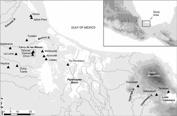
We evaluate viewership differences within the site hierarchy for three primary, six secondary, and one tertiary center for the western lower Papaloapan basin (WLPB), and for three primary centers in the southwestern Tuxtla Mountains, Veracruz, Mexico (Figure 1). We find that viewership of games is notably restricted relative to plaza capacities. Games may have had many political, sacred, and social roles, including social integration, but the game also was socially divisive in viewership.
Locations of selected sites mentioned in the text for south-central and southern Veracruz. Inset map shows the location within Mesoamerica. The map background was adapted from a continuous elevation module and river file from the Instituto Nacional de Estadística y Geografía, Mexico.

The Mesoamerican Ballgame and Its Social and Political Implications
The Mesoamerican Ballgame (Scarborough and Wilcox Reference Scarborough and Wilcox1991) and later publications advanced arguments about the political and social roles of the ritual ballgame. DeBoer (Reference DeBoer1993) did the same for the North American chunkey game, which he argued become more centralized under Cahokia. We continue the focus on the social and political dimensions of court games by examining the degree to which Mesoamerican architectural courts measure up as public facilities. How many people could see the action of the game relative to the capacity of main plazas where the city's most prominent public rituals took place?
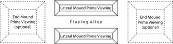
Unlike North American “chunk yards,” which at Cahokia consisted of a central field area (Pauketat Reference Pauketat2009), Mesoamerican architectural courts are constructed with two parallel platforms with sloping sides that frame a flat playing alley (Figure 2). Courts vary in size and orientation. The ends of the court are subject to varying treatments, and courts may have other architectural elements, such as side rings, floor markers, or benches (Taladoire Reference Taladoire1981), and rarely, sculpted panels (Castillo Peña Reference Castillo Peña1995; Kampen Reference Kampen1972; Ladrón de Guevara Reference Ladrón de Guevara1999). Interpretations of the ballgame differ in part because the game was played in variable ways, reflecting regional traditions (Taladoire Reference Taladoire1981). Courts may have been used for other events (e.g., boxing matches [Taube and Zender Reference Taube, Zender, Orr and Koontz2009] or ritual battles [Taladoire Reference Taladoire2011, Reference Taladoire2012a]).
Schematic drawing of Mesoamerican open-ended ball court with end mounds.

The lateral mounds would have accommodated viewers only on top because the inner sides had roles in the game itself, allowing deflection of balls. The slopes of platforms flanking the court were not bleachers. West Mexican ceramic effigies of courts, players, and viewers show people seated on the flanking mounds and around the end zones, as does a graffito from Tikal (Taladoire Reference Taladoire2012b). Sometimes one or both ends of the court have a low mound that may have provided a “viewing stand,” but open-ended courts are prevalent in the Gulf and Maya lowlands (Taladoire Reference Taladoire1981). In the cases examined here, end zones are usually open, though occasionally a low end mound likely accommodated viewers. We cannot rule out wooden bleachers at the open ends, but no supporting evidence has yet been uncovered. For open-ended courts, we assume viewers stood around a designated end perimeter, also providing stops for errant balls. In many regions, T-shaped end zones are enclosed with walls, unlike the courts addressed here. With such courts, people could have sat on the walls with others standing behind them.
The architectural framing of the court has a marked effect on who gets a good view of the action. We define “prime views” as those enjoyed by people standing or sitting atop the flanking mounds, standing along the open end zones, or perched on an end mound (bleacher-like). Sometimes structures farther away afforded “secondary views,” but one has to consider the effects of distance and people around the court blocking lines of sight. Many surrounding structures were temples or palaces—buildings for which access may have been controlled and for which the facades (typically plastered or finished with a sealant if made of earthen construction) would have been vulnerable to damage from viewers scaling the sides (concerning Gulf earthen construction, see Daneels and Guerrero Reference Daneels and Guerrero2013). A series of games may increase total population reached by a single architectural court, and we return to this subject in the Discussion and Conclusions section.
The conformity of the architectural courts raises the possibility that viewership was deliberately limited. Construction of mounds flanking the court originated quite early in Mesoamerica on the basis of Chiapan evidence dating around 1600 BC (Hill and Clark Reference Hill and Clark2001). The early court at the village of Paso de la Amada, Chiapas, is long (80 m), and the flanking mounds and end zones may have provided prime viewing to a majority of that small community. At later (and larger) centers, a smaller proportion of the population could watch in these positions. In some parts of Mesoamerica, later courts were sunken, reducing possible secondary viewership (Chinchilla Mazariegos Reference Chinchilla Mazariegos, Orr and Koontz2009:146).
Informal ballgames may have been played on an open, demarcated field area, like the surviving games in western Mexico (Leyenaar Reference Leyenaar and Whittington2001; Leyenaar and Parsons Reference Leyenaar and Parsons1988:94–148; see also Whalen and Minnis Reference Whalen and Minnis1996). We term these “field courts” in contrast to architectural courts, and later we discuss their possible social significance. The viewership numbers provided here apply only to architectural courts. Widespread interest in the ballgame may have been achieved through a mix of formal occasions and “sand lot” events open to anyone (Miller and Houston Reference Miller and Houston1987). Like soccer in Latin America today, playing the ballgame among the general population generates interest in professional events and vice versa.
Investigators recognize different social and political roles for the game, some of which have implications for viewership. These range from external political functions (Kowalewski et al. Reference Kowalewski, Feinman, Finsten, Blanton, Nicholas, Scarborough and Wilcox1991), to internal mediation (e.g., Fox et al. Reference Fox, Ashmore, Blitz, Gillespie, Houston, Leyenaar, Marcus, Moore, Urban, Schortman and Webster1996; Gillespie Reference Gillespie, Scarborough and Wilcox1991; Taladoire Reference Taladoire2011, Reference Taladoire2012a), to recreational events (Anderson Reference Anderson and Braswell2012; Fox et al. Reference Fox, Ashmore, Blitz, Gillespie, Houston, Leyenaar, Marcus, Moore, Urban, Schortman and Webster1996:494; Scarborough Reference Scarborough, Scarborough and Wilcox1991:141–142). Some authors suggest the game recognized social divisions (Gillespie Reference Gillespie, Scarborough and Wilcox1991:342; Taladoire Reference Taladoire2011, Reference Taladoire2012a; Wilkerson Reference Wilkerson, Scarborough and Wilcox1991:55), promoted social unity (Agüero Reyes et al. Reference Agüero, Ofelia, Daneels, Orr and Koontz2009; Daneels Reference Daneels, Arnold and Pool2008, Reference Daneels2016; Fox Reference Fox, Scarborough and Wilcox1991:213), or indicated the degree of political centralization (Liendo Stuardo Reference Liendo Stuardo2015; Santley et al. Reference Santley, Berman, Alexander, Scarborough and Wilcox1991). Cosmic-symbolic considerations are a recurrent scholarly preoccupation (e.g., Aguilar-Moreno Reference Aguilar-Moreno2015; Baudez Reference Baudez1984 cited by Taladoire and Colsenet Reference Taladoire, Colsenet, Scarborough and Wilcox1991; Cohodas Reference Cohodas, Scarborough and Wilcox1991; Fox Reference Fox, Scarborough and Wilcox1991; Miller and Houston Reference Miller and Houston1987:63; Scott Reference Scott, Heather and Koontz2009; Uriarte Reference Uriarte2015). If political leaders, especially rulers, positioned themselves prominently in ballgame rituals, augmentation of political stature ties the ritual and symbolic dimensions of the game to its political side.
Some social and political interpretations hinge on the number and location of courts in relation to the centralization of political power, with the idea that the privilege, authority, and resources to build a court depended on the autonomy and power of the community. According to Santley and coauthors (Reference Santley, Berman, Alexander, Scarborough and Wilcox1991), many courts at various differently sized settlements indicate weak centralization. Both restriction of courts to the biggest settlements and placement mainly along frontiers suggest centralized control of the facilities in Oaxaca (Kowalewski et al. Reference Kowalewski, Feinman, Finsten, Blanton, Nicholas, Scarborough and Wilcox1991).
Alternatively, the game could be theorized as an institution that integrates communities through popular participation (Agüero Reyes et al. Reference Agüero, Ofelia, Daneels, Orr and Koontz2009; Daneels Reference Daneels, Arnold and Pool2008, Reference Daneels2016). In this reasoning, internal social differences are recognized competitively through the game, but people are also unified because games are played at a variety of settlements, creating cross-cutting relationships. In the data we examine, courts appear in primary and secondary centers, and rarely in smaller centers or other specialized contexts (such as part of a palace complex). Therefore, they exemplify a well-distributed pattern, similar to that reported by Daneels (Reference Daneels, Arnold and Pool2008, Reference Daneels2016) for the lower Cotaxtla River valley in south-central Veracruz. Our research both supports and modifies the integrative perspective because we show that viewership in architectural courts was far less than the quantity of people who could be accommodated in the main plazas of Gulf lowland centers; therefore, the games had a more restrictive integrative role.
Interpretations of Mesoamerican Public Plazas
Plazas are public Mesoamerican facilities par excellence, usually accommodating relatively large numbers of people (Tsukamoto and Inomata Reference Tsukamoto and Inomata2014), potentially drawn from the site, the surrounding hinterland, and even other centers. A plaza is a public open space delimited by buildings of predominantly civic, religious, or commercial function. Usually the plaza is framed on all sides, but in some regional traditions, the presence of buildings on only two or three sides can imply a quadrilateral form. Kostof (Reference Kostof1992:149–152) notes a wide variety of plaza forms worldwide, including irregular spaces, but Mesoamerican plazas tend to be quadrilateral (e.g., Solari Reference Solari, Tsukamoto and Inomata2014), compatible with cosmic principles and cardinality. We concentrate on the “main plaza,” which is surrounded by the most prominent civic, palatial, or religious structures in the settlement. Rarely, there may be more than one such plaza.
Mesoamerican plazas vary considerably in area (Ossa et al. Reference Ossa, Smith, Lobo and Ortman2017; Tsukamoto and Inomata Reference Tsukamoto and Inomata2014), as do Andean plazas, which has implications for their functions (Moore Reference Moore1996a). Ethnohistoric, soil chemistry, and artifact studies indicate multifunctionality (Ossa et al. Reference Ossa, Smith, Lobo and Ortman2017). For the central precinct at the Aztec capital of Tenochtitlan, López Austin and López Luján (Reference López Austin, López Lújan, Nichols and Rodríguez Alegría2017) note that calendric festivals included ritual, processions, dances, and other activities. Ritual observances have been emphasized in Maya plaza interpretations (e.g., Inomata Reference Inomata2006; Tsukamoto and Inomata Reference Tsukamoto and Inomata2014), and feasting has been argued from soil chemistry studies (e.g., Fulton et al. Reference Fulton, Christian Wells and Storer2013; Wells et al. Reference Wells, Novotny, Hawken, Glascock, Speakman and Popelka-Filcoff2007). Unlike Tenochtitlan, which had a designated area for a daily market, many smaller centers would use their plazas for periodic markets or overflows from a dedicated space (Chase and Chase Reference Chase and Chase2014; Chase et al. Reference Chase, Chase, Terry, Horlacher, Chase and King2015; Dahlin et al. Reference Dahlin, Jensen, Terry, Wright and Beach2007, Reference Dahlin, Bair, Beach, Terry, Staller and Carrasco2010; Terry et al. Reference Terry, Bair, Coronel and King2015).
Plaza capacities are an interpretive issue. Some investigators (e.g., Inomata Reference Inomata2006) have argued that main plazas could have accommodated most of the population of a site. We do not pursue a comparison to site populations because we lack reasonably precise population estimates for the set of centers examined.Footnote 1 Plaza capacities may reflect diverse design principles. Some plazas may have been “overdesigned”; that is, larger than any expected crowd in order to create an imposing spatial grandeur, perhaps symbolizing the importance of a center, establishing room for processions, or accommodating sculpture or other displays. Plazas may have been constructed for occasional assemblies that included people from beyond the site, perhaps neighboring settlements. Ossa et al. (Reference Ossa, Smith, Lobo and Ortman2017) show that as settlements increase in population, plaza space does not increase at the same rate. Assembled crowds surely varied widely in numbers with the occasion. Our interest, nevertheless, is in the comparison of estimates of maximum ballgame viewers with maximum main plaza capacity to address degrees of exclusivity.
We calculate plaza capacities two ways, drawing on information provided by Moore (Reference Moore1996a:149) on Andean plazas. Moore drew on three estimates of densities, all expressed as the area attributed to a single person: 0.46 m2, 3.6 m2, and 21.6 m2. He argued the densest packing is unlikely and far above the population estimates of some Andean sites. The lowest density of 21.6 m2 includes too few individuals for events at some small Andean plazas. The middle value of 3.6 m2 in effect remains more plausible to him. Ethnographic information warranting these values is extremely scarce and does not provide much guidance for estimating maximum packing. We opted for two densities within the range described by Moore: 0.5 m2 and 2 m2 per person, selected somewhat arbitrarily to represent upper and lower high-packing assumptions. Note that only the 0.5 m2 packing is used for areas of ballgame viewers, however, because prime game-viewing space was so limited that we assume the highest packing.
Assessing Ballgame Visibility in the Gulf Lowlands: Data and Methods
We use two methods to determine ballgame viewership. The first employs plane geometry and scaled measurements to determine lines of sight toward the center point of the courts. For the WLPB, this largely pencil-and-paper method (M1) was used to calculate viewership for primary and secondary centers (Stark Reference Stark, Daneels, Donner and Hernández Arana2012) to determine if viewership restrictions differed according to the settlement hierarchy (Stark Reference Stark2014b). Perhaps at secondary centers viewership was less restrictive because local leaders were less powerful, allowing more social integration.
Our second method (M2) is more exact, using viewsheds calculated in ArcMap 10.2.2 (ESRI) with digital elevation modules (DEMs) interpolated from vector contour maps. The second method was applied to the three primary centers in the WLPB and three in the southwestern Tuxtlas, plus one WLPB secondary center (Tuzales), undertaken first as a smaller test case. GIS computer programs can precisely calculate viewsheds—the areas for which lines of sight exist.
The two methods provide flexibility, and we compare results for the epicenters analyzed both ways. Not all investigators have access to, or expertise in using, viewshed programs for ball-court analysis, nor is precise quantification always required to reach basic conclusions about access and visibility. In both methods, there are challenges and assumptions, sometimes differing according to the method.
Data Sources
Data are drawn from two Gulf locales where we have access to contour maps or DEMs. The Mesoamerican ballgame has a long history in the Gulf lowlands, with indications as early as Gulf Olmec times during the Early Formative period (1200–900 BC; Daneels Reference Daneels and Teresa Uriarte2015; Ortíz et al. Reference Ortiz, del Carmen Rodríguez, Delgado, Teresa Uriarte and Teresa Uriarte2015). As noted, we examine site epicenters from the Classic period (AD 300–900). We converted WLPB maps to vector images and then used contours to interpolate DEMs. Tuxtlas vector maps have not been analyzed with the manual procedures because the viewshed approach (M2) is more precise.
Western Lower Papaloapan Basin (WLPB)
We examined 63 monumental or quasi-monumental complexes in primary and secondary centers from several projects (Speaker Reference Speaker2001; Stark Reference Stark1999, Reference Stark, Arnold and Pool2008; Torres Guzmán Reference Torres Guzmán1972; Torres Guzmán et al. Reference Torres Guzmán, Antonio Reyes, Ortega and Mexicana de Antropología1975). Surface collections from site epicenters and surrounding occupation establish the Classic period (AD 300–900) dating for the centers and their ball courts. Antecedent courts may have existed at Cerro de las Mesas, where a yoke was interred with a burial likely between AD 1 and 300 (Daneels Reference Daneels, Stark and Arnold1997:220; Drucker Reference Drucker1943:8; Stirling Reference Stirling1941). No courts are evident at the two Postclassic towns in the survey area. The great majority of the courts occur in formal arrangements at centers that display “Standard Plan” plazas (Daneels Reference Daneels2002), which dominated during the Classic period.
At the Standard Plan plaza, a high conical mound is accompanied by one or two elongated mounds on the sides of a relatively square plaza, with an architectural court at the opposite end. Typically, the court axis is the same as the plaza axis crossing the conical mound; the courts rarely have transverse orientations. None of the courts analyzed have been excavated, and we do not know about architectural details, sculpture, or offerings.
In the WLPB, the courts are usually open on both ends (27 cases), which is the Type 1 form described by Taladoire (Reference Taladoire1981) as common in the Maya lowlands. Annick Daneels (personal communication 2016) reports that excavations at El Tajín exposed low end zone walls (<0.8 m); if these had been constructed in the WLPB, they would have used earthen materials that possibly eroded to invisibility. A few courts (six cases) have a low mound, possibly a viewing stand, at one end. End mounds are more common in the next drainage west, the Cotaxtla (Daneels Reference Daneels2002, Reference Daneels2016).
Twenty-four courts were mapped, with nine other possible cases. Only 17 courts from 11 centers are analyzed here because of damage to court mounds or obstacles to contour mapping. A “possible court” is a low mound displaying court-like proportions and located in the usual position in the Standard Plan plaza but which has suffered severe erosion. In the Cotaxtla drainage, courts often sit on low platforms, but this arrangement has not been detected in the WLPB.
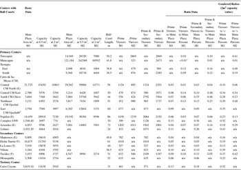
The length of flanking mounds affects the amount of prime viewing, assuming some audience members watched from on top. Only provisional length measurements can be provided using flanking structures (we use the longest one in Table 1). In the WLPB, the flanking mounds are approximately equal in height, usually between 30 and 50 m long (similar to Tuxtlas primary centers). The longest is 86 m in the central court of Nopiloa, a Late Classic primary center (AD 600–900). The smallest is 24 m, in Lobato, a semimonumental complex that was possibly a small community center. It is located near the proposed edge of the Azuzules primary center and may have been a “border complex” on its perimeter (Stark Reference Stark, Creekmore and Fisher2014a).
Descriptive and Ratio Data for the Ball Courts and Plazas Analyzed.

Notes: Calculations here are carried to a precision of one person, beyond the significant figures of the assumptions. M1 is manual method; M2 is GIS viewshed method. (T) transverse ball court; (E) end zone mound; n/a, not applicable.
a This figure reflects the large area covered by the Great Plaza.
b The ball court is likely, but due to a fence line and plowing, not as secure as the others.
The three WLPB primary centers included in the analysis are Cerro de las Mesas (Drucker Reference Drucker1943; Stark Reference Stark, Mastache and Sanders2003; Stirling Reference Stirling1943), Nopiloa (Medellín Zenil Reference Medellín Zenil1987), and Azuzules (Stark Reference Stark1999). Cerro de las Mesas was the capital of the WLPB during the Early Classic period (AD 300–600), but the other two centers operated independently along with Ajitos-Pitos during the Late Classic when the Cerro de las Mesas realm disintegrated (Stark Reference Stark, Mastache and Sanders2003). Ajitos-Pitos, located in the paleodunes, is omitted because heavy vegetation prevented contour mapping. We also exclude a center in the mangrove swamp.
Among the primary centers analyzed, the epicenter of Cerro de las Mesas is unique because it has an agglomerative quality, with several Standard Plan plaza groups (Stark Reference Stark, Mastache and Sanders2003), perhaps representing community factions. Two ball courts are associated with central Cerro de las Mesas, and four more are distributed around the outer perimeter of the epicenter (one is a possible court). Five of the six ball courts can be analyzed. The central Cerro de las Mesas-North court is at the edge of the largest main plaza, surrounded by some of the biggest architecture. For the five Cerro de las Mesas courts, we made calculations using the adjacent main plazas for each, and not all plaza areas combined. Other WLPB primary centers have a single dominant plaza and court.
In addition to the three primary centers, six secondary centers and one tertiary center have sufficient preservation to permit analysis. We also include two subsidiary complexes within primary centers that have ball courts. These two include one palatial platform with a court in its immediate cluster of mounds (mound 6309 complex at Nopiloa) and the already mentioned small Azuzules border complex, Lobato.
Southwest Tuxtla Mountains
From the Tuxtla Mountains we include three primary centers: Matacapan (Santley Reference Santley2007), Teotepec (Phillip J. Arnold III, personal communication 2016; Thompson et al. Reference Thompson, Arnold and VanDerwarker2009), and Totocapan (Stoner Reference Stoner2011). Research at Matacapan during the 1980s (Santley Reference Santley2007; Santley et al. Reference Santley, Robert, Ortiz Ceballos, Arnold, Kneebone, Smyth and Kerley1984; Santley et al. Reference Santley, Robert, Ortiz Ceballos, Arnold, Kneebone, Smyth, Kerley, Berman, Hall, Kann, Pool, Salazar and Yarborough1985) was followed by the Tuxtlas Regional Survey along the Catemaco River and north to the coast (Santley Reference Santley1991; Santley and Arnold Reference Santley and Arnold1996). Ball courts are not abundant. Matacapan (Santley Reference Santley2007), Chuniapan de Abajo, and possibly Chuniapan de Arriba (León Estrada and Wilson Reference León Estrada and Wilson2015) are the only centers in the Catemaco valley with architectural courts, along with Teotepec and Isla Tenagre in the Lake Catemaco basin (León Estrada and Wilson Reference León Estrada and Wilson2015; Santley and Arnold Reference Santley and Arnold1996) and Matacanela south of the lake (Venter Reference Venter2014). The small ball court at Matacapan was constructed between AD 300 and 650.
Two ball courts at Teotepec are among the Classic period architecture, with one forming the terminus of a plaza group that resembles the Standard Plan described above but with a more elongated rectangular shape like the “long-plaza group” found south and east of the Tuxtla Mountains (Borstein Reference Borstein2001; Symonds et al. Reference Symonds, Cyphers and Lunagómez2002; Urcid and Killion Reference Urcid, Killion, Arnold and Pool2008). Notably, Matacapan does not display architectural arrangements that closely adhered to either of these Gulf lowland patterns, perhaps reflecting the foreign identity of its founding population (Santley Reference Santley2007; Stoner and Pool Reference Stoner and Pool2015).
Totocapan was mapped with compass, tape, and handheld GPS during the Tepango Valley Archaeological Survey (Stoner Reference Stoner2011). Later, Stoner obtained the Light Detection and Ranging (LiDAR) point cloud from INEGI that permitted an accurate and detailed digital elevation module (DEM) for the central part of Totocapan (Stoner and Pool Reference Stoner and Pool2015:Figure 8)Footnote 2 . Totocapan possesses four ball courts. The largest, used for this analysis, occupies the end of a Standard Plan plaza. Dating of this architectural complex is uncertain, but Totocapan was almost completely abandoned by the beginning of the Early Postclassic (ca. AD 900; Stoner Reference Stoner2011:292–295). The configuration of mounds at the site resembles that of Mound Group 2 at Tres Zapotes (Pool Reference Pool, Arnold and Pool2008), which was likely built sometime after 400 BC.
Elsewhere in the Tepango valley, survey identified single ball courts at the secondary centers of Tilzapote and Xiguipilincan and the tertiary center of Cruz de Vidaña. Tilzapote and Xiguipilincan reached their maximum sizes between AD 450 and 900. Both also had Postclassic occupations, but the ball courts were integrated into typical Standard Plan configurations. Cruz de Vidaña reached its apogee 400–1 BC, raising the possibility that court construction was earlier than others in the valley. Only sketch maps exist for these three centers, so they are omitted from the viewshed analysis. The existence of ball courts at secondary centers in the Tepango valley resembles the WLPB and the Catemaco River and Lake region.
Visibility Methods
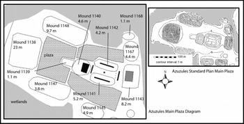
As noted, we apply two methods to assess viewership but each relies on the same three categories of information: (1) the plaza area; (2) the prime viewing opportunities for courts: the tops of the flanking mounds, the open end zones and contiguous open space, and, if present, the interior side of an end zone mound; and (3) secondary viewing areas located on the tops or sides of other structures that do not immediately surround the court. Recall that secondary viewing is dubious because viewers may not have been permitted to climb the platforms given the vulnerability of facades or sacred or private space restrictions. Rarely, a mound with secondary viewing is positioned so that its presumed stair would afford a good view of the game (such as Figure 3, Mound 1143, at Azuzules).
Example of manual viewership information for the Standard Plan plaza of Azuzules. Thick black lines represent primary viewers, with six individuals per linear meter. Black rectangle indicates an area of primary viewers on an end mound. Dark gray rectangle (on Mound 1143) represents secondary viewers. No other mounds have a line of sight to the court center point (star) within a 100 m radius. The main plaza is indicated with three shaded polygons.

In south-central Veracruz, stone for architecture is lacking, and construction uses rammed earth or adobe blocks with earthen fill (Daneels and Guerrero Reference Daneels and Guerrero2013). Consequently, with time, erosion creates a softened contour for mounds. Without excavation, the original level of the court playing alley, which traps erosional sediment, cannot be determined, causing us to assume that it was at the same level as the surrounding plaza. We correct the DEM court alley elevations to match the surrounding surfaces.
The width of the narrow playing alleys cannot be estimated usefully because of erosional material, so we evaluate visibility to a center point. The GIS viewshed calculations (M2) used a 1 m positive elevation offset from the court center to approximate the belt level of players, with the idea that if viewers can see to belt level, they can follow the game. In the manual method (M1), secondary viewing was determined on graph paper for an arbitrary point representing the court center on the playing alley surface, with structures placed at an appropriate scaled distance with their scaled height. Each measurement method has valid reasoning, but the M1 method decreases secondary viewership slightly due to the use of the center point at the ground surface.
For ball-court lines of sight over standing viewers, people were 1.5 m high in both methods. We limited viewership to 100 m distance in both methods because of the difficulty of seeing the game well at a greater distance. Increased distance would mainly increase secondary viewership from elevated positions on other structures.
In the manual method (M1), capacities for people standing aligned to see the game (on top of flanking mounds or across the end zones) relied on six people per linear meter (three people deep), with the assumption of views across others’ shoulders on the basis of experiments with sets of people (Figure 3). Beyond six people per linear meter, views would be only fragmentary or occasional. Lines of sight at greater distances are determined by clearance of the heights of flanking structures or end mounds plus 1.5 m (people standing on top) or people of that height standing around open end zones.
For M1 areas of viewers, such as on the side of a mound, densities applied are one person per 0.5 m2. In GIS viewshed analyses, onlookers are represented by a random population of points to achieve the same density as plaza areas. The program automatically determines which have lines of sight.
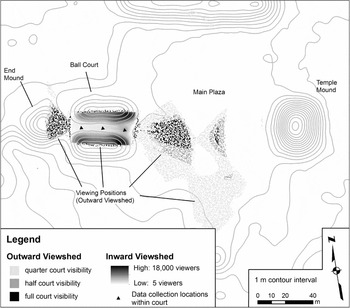
Both inward and outward viewsheds (M2) were calculated for ball courts for the six primary centers (and Tuzales; Figure 4), although only the inward viewshed results to the center point of the ball court are tabulated here. Observation points to conduct inward viewsheds were constructed by randomly generating eight points per 4 m2 (2 m × 2 m fishnet) requiring at least 0.3 m between points. This procedure results in the same crowd density as the manual calculationsFootnote 3 . The points are then rasterized and given a height of 1.5 m above the ground surface with grid dimensions of 0.5 m × 0.5 m. The crowd-interference raster, which represents the bodies of ballgame viewers, is added to the site DEM. The observation points, perched atop the crowd “columns,” provide the input features to calculate visibility using the “visibility” toolbox in ArcMap 10.2.2. Then, the frequency of observation points that can see every raster square in the DEM is calculated (with a 1 m offset to simulate the belt level of ballgame players).
Example of the GIS calculation of inward and outward viewsheds for Totocapan. Outward viewshed observation locations are represented by the shaded raster squares that expand out in fan-like shapes from the ball court. Each square represents one individual. The inward viewshed is represented by the continuous gray-scale gradient located within the ball court. For comparison to the manual method, inward viewshed values (in number of viewers) were recorded at only the central data collection point (triangle) within the ball court.

The calculations were run twice. The first run included all viewers within a 100 m buffer (i.e., both prime and secondary viewers). The second run omitted secondary viewers from buildings not directly forming part of the architectural ball court.
Plaza Calculations
For both methods, we used 0.5 m2 and 2 m2 per person in order to assess two possibilities for maximum capacities. Plaza areas in the manual method (M1) were taken from polygons drawn on GIS “footprint” maps of centers (Mapinfo Professional 6.5). The rectilinear polygons were not closely aligned against the bases of structures in these simplified maps, but in the GIS method (M2), the polygons were fitted closely against the base contours of structures, providing a better estimate of maximum plaza area. The manual method allows more space for circulation around the plaza. Similarly, the lower packing figure of 2 m2 also permits more circulation.
Discussion of Methods
The calculations are inexact with both methods. We cannot assess plaza areas very precisely because we lack the excavated edges of structures and must use their eroded edges. Likewise, court viewing is based on the assumption that special wooden bleachers were not constructed. Any perishable roofed structures atop the flanking mounds of the court would affect some distant lines of sight to the court and might also constrain viewership from the flanking mounds themselves. The highest ranking individuals on flanking mounds may have been seated, but these details are not available and at most would add a small additional viewership if individuals could stand behind them.
Annick Daneels (personal communication 2016) raised the question of whether prime viewers were mainly adult males. If so, plaza figures for 0.5 m2 packing should be adjusted downward by 75% for the purposes of comparing the exclusivity of ballgame viewership, assuming minimally one in four persons was an adult male. This is effectively the 2 m2 packing. We provide data for such an adjustment, but a gendered restriction cannot be directly evaluated. Ceramic effigies of ballgames from West Mexico show female spectators, although in lesser amounts than males. We suspect that high-ranking women would often be part of the prime viewers.
Results of Ballgame Viewership and Plaza Capacity Analysis
Comparison of Methods
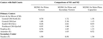
Table 1 presents the plaza areas, capacities, and viewership data for prime and secondary locations. We use ratios of Method 2 (viewsheds) to Method 1 (manual) to readily highlight viewership differences between the methods (Table 2). A ratio above 1 indicates that M2 yields higher numbers of viewers.
Ratios to Compare the Two Methods Using 0.5 m2 Packing in Plazas.

Notes: M1 is manual method; M2 is GIS viewshed method. (T) transverse ball court; (E) end zone mound.
For solely prime viewers, manual calculations exceed the GIS viewshed calculations in five of the seven cases (ratios less than 1); the two cases of higher GIS counts are due to the inclusion of people in neighboring plaza areas. The five higher manual values reflect the use of packed lines of viewers around the court in contrast to the viewshed model of person-columns.
As noted, we have great doubt that secondary viewing was generally permitted. For the most part, the viewshed approach yields more prime-plus-secondary viewers. In most cases M2 viewership (prime and secondary) is close to two times the manual method, but for Central Cerro de las Mesas-East, it is five times greater. This aberrant value is due to a much larger secondary viewership calculated for nearby mounds in viewshed analysis. In contrast, the manual method assumed that a single area of packed viewers on each mound precluded more distant viewers. This discrepancy in results is a good example of the advantages of viewshed analysis over occasionally misleading assumptions when marking off secondary viewer areas in the manual method. In general, the systematic accuracy of the viewshed calculations is superior for secondary viewers.
Method 2 to Method 1 ratios of plaza areas (Table 2) show that the effort to better measure maximum plaza area for the viewshed analysis produced up to 36% larger areas (therefore with ratios above 1).
Degree of Restriction for Prime Viewers Compared with Plaza Capacities
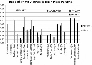
A ratio of prime viewers to main plaza capacities (using 0.5 m2 per person) summarizes whether ball-court viewership was highly restricted in comparison to prominent public assembly space in each method (Figure 5). The relationship of prime viewership to plaza capacity is prima facie unlikely to be 1 to 1 because of the ball-court architecture. A high ratio, between 0.5 and 1, would suggest the courts served a sizable proportion of the maximum formal assembly capacity. As the ratio drops, ball courts become more exclusive. A ratio of 0.25 to 0.5 would still be fairly generous in serving people (e.g., more than just elites). A ratio below 0.25 we define as restricted access, which is the bracket that encompasses our prime ratios using 0.5 m2 packing.
Comparison of manual (M1) and GIS viewshed (M2) results for ratios of prime viewers to plaza capacities (people). The smaller the ratio, the more exclusive ballgame viewership. E indicates an end mound, and T indicates a transverse court. Cerro de las Mesas is abbreviated as CM.

The highest observed ratio is 0.14 for a partial Standard Plan plaza group in Central Cerro de las Mesas-East with the viewshed calculations, with Teotepec-East close behind at 0.12. With the manual method, the sole tertiary settlement, Coyote, is 0.13, and two small “part” complexes that are within primary centers are above 0.10. Thus, both third-order sites and “partial” settlement groups are more inclusive in ballgame viewing than most other groups. Other ratios are well below 0.10.
Interestingly, estimates of the proportion of elites to nonelites in ancient societies do not deviate markedly from the restrictive proportions of prime ballgame viewership to total assembly size in plazas. Michael Smith (personal communication 2016) suggested sources for estimates of the proportions of elites in various societies (e.g., Bodley Reference Bodley and Sharpe2003:94, 98; Braudel Reference Braudel and Reynolds1982; Flannery Reference Flannery, Flannery and Marcus1983:136; Lenski Reference Lenski1966:219; Rojas Reference Rojas, de Cultura Económica and de Michoacán1986:97; Smith Reference Smith, Hodge and Smith1994:320; Tacoma Reference Tacoma2006:94, 95). A range from 0.01 to 0.10 captures most of the estimates, not much different from our ratios of prime court viewership to maximum plaza capacity. One potential derailing factor, however, is that game viewers could change across a series of games (see Discussion and Conclusions).
As noted, viewshed calculations were performed for primary centers in the WLPB and Tuxtlas areas, but the manual method was applied to all centers in the WLPB settlement hierarchy (Figure 5). Ratios of prime viewership to plaza capacities for both primary and secondary centers fall at or below 0.10, and five are at or below 0.05. The ballgame was therefore much more exclusive than plaza assemblies regardless of settlement rank.
We have expressed doubts about the validity of secondary viewing by people who climbed to vantage points on nearby structures. Nevertheless, we provide information on the combined primary and secondary viewership for readers who do not want to discard this possibility (Table 1). Secondary viewers occasionally make total ballgame viewership fairly generous in public access, in some cases almost reaching 0.50, but the majority of courts have ratios in the restrictive bracket.
Also, we expressed doubts that only men viewed the game, but we provide these data (Table 1). If, minimally, one in four people were adult men, plaza capacities must be adjusted downward correspondingly for comparison. This adjustment is the same as the less dense packing assumption of one person per 2 m2. Although a couple of ratios barely pass the 0.50 mark to enter the bracket representing a sizable proportion of plaza capacity, the other ratios are approximately divided between the fairly generous bracket (0.25–0.50) and restrictive bracket (<0.25).
Dissecting Results for the Western Lower Papaloapan Basin Settlement Hierarchy
Centers vary in their ratios of prime viewers to plaza capacities, but the variation does not appear to be linked to the settlement hierarchy in the WLPB (Figure 5). Primary and some secondary centers have overlapping ranges of scores, with no consistent relationships, given the sample size. It is important to disaggregate the elements of the ratio to better evaluate their expression in settlement hierarchies. In doing so, we discover that the similarity in ratios is likely due to architectural canons because individual measures differ between primary and secondary (or lower) settlement ranks for (1) ball-court lengths, (2) plaza sizes, and (3) prime viewer counts.
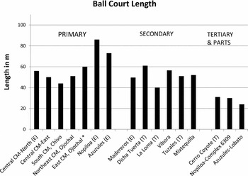
WLPB ball-court lengths (i.e., of the longest flanking mound) are shorter at secondary centers (Figure 6) than primary centers (Azuzules and Nopiloa) during the Late Classic period. During the Early Classic period, the multiple courts at Cerro de las Mesas are similar to those of secondary centers.
Ball-court lengths according to settlement ranks in the WLPB. Abbreviations are the same as for Figure 5.

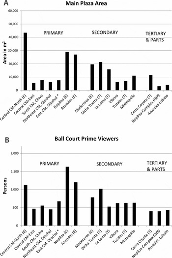
Primary centers have larger main plazas than secondary centers (Figure 7A), although some main plazas within Cerro de las Mesas are similar to some secondary centers on this measure. Primary centers also have higher prime court viewership (Figure 7B). To some extent, greater viewership is due to the addition of end mounds at one of the Cerro de las Mesas courts and at the Nopiloa and Azuzules courts. Only one secondary center (Madereros) has an end mound. Viewership values at some of the additional courts at Cerro de las Mesas are similar to those of some secondary centers.
(A) Main plaza area in m2 according to settlement ranks in the WLPB using the manual method measurements and 0.5 m2 packing. (B) Ball-court prime viewers for settlement ranks in the WLPB using the manual method. Abbreviations are the same as for Figure 5.

In sum, primary centers have more resources, grander installations, and more prime game viewing than secondary (or tertiary) centers in this sample. These patterns for individual values help establish that ball courts vary in size, reflecting the prominence of the settlement, especially in the Late Classic period. The degree of repetition of the Standard Plan, with its tendency toward a square rather than elongated plaza, suggests a shared underlying concept of architectural ingredients and proper proportions. These proportionalities contribute to the lack of clear discrimination among ratios of ballgame viewing to plaza capacity for primary versus secondary centers. Smaller centers tended to maintain a reduced but consistent relationship among the various architectural elements.
Counts of Prime Viewers and Plaza Capacities
We briefly examine individual measures for prime viewers and plaza capacities, which offer insights apart from ratios. Maximum prime viewership at the primary centers is calculated as 500–2,000 people with the manual method and 300–3,000 with viewshed analysis, but the latter range drops to 300–1,000 if the outlier of Totocapan is eliminated. Totocapan is exceptionally high in prime viewers because a slightly elevated playing surface and upward sloping terrain permit more people in plaza areas to see the game. Totocapan demonstrates that even subtle variation in the plans of urban architects can have dramatic effects on public experience of rituals and games.
With 0.5 m2 packing, the main plazas at primary centers could accommodate 6–40 × 103 people using the conservative values in the manual method (M1) and 4–200 × 103 people using more complete area measurements done in M2; nevertheless, the highest M2 value (Matacapan) is an extreme outlier. The quantity of 6 × 10⁴ for Cerro de las Mesas-North is a more useful upper value for the M2 results, but even this plaza is a marked outlier compared to other Cerro de las Mesas plazas and other primary centers (excluding Matacapan). It raises the possibility of an “overdesigned,” grandiose plaza with a capacity that likely exceeded population in the immediate area.
With 2 m2 packing, the M1 plaza range for primary centers is 1–10 × 103 and M2 is within the same order of magnitude (Matacapan excluded). With this packing, Cerro de las Mesas-North remains large compared to other primary center plazas but not as likely to exceed possible assembled crowds from the immediate area.
Discussion and Conclusions
To summarize, we have evaluated the numbers of people relevant to two open-air facilities in the Gulf lowlands: ball courts and main plazas. Despite their public prominence and high accessibility in the site epicenters, they differ greatly in the numbers of people who could be accommodated to view events. Prime viewing of the ballgame was markedly lower in numbers of viewers compared to potential plaza assemblies. The presence of ball courts at both secondary and primary centers in the WLPB and southwest Tuxtla Mountains suggests multiple points of sponsorship of facilities and games, and perhaps thus a degree of collective action through secondary elites, rather than highly centralized regimes providing only a court at primary centers. In the WLPB, we noted that the ratios of ballgame viewers to plaza capacities do not differ noticeably between primary and secondary centers, because proportionalities in architectural canons mask the greater investments in higher-order centers when ratios are considered.
The possibility of sequential court use requires consideration before we conclude that architectural courts were relatively exclusive compared to plazas on the basis of our calculations. Perhaps any teams or individuals could practice or play at a formal court, taking turns, with only some games of ritual or political importance attended by more important members of the society. The possibility of such generalized use of formal courts cannot be ruled out, but any noteworthy competitions likely would have been of interest to important families to watch, in addition to the most ritually or politically prominent games. Thus, even with rotational use, viewership limitations would have favored the privileged over the general population. The ritual and sacred importance of the ballgame discussed above does not suggest casual, informal use of architectural courts.
Consequently, the architectural ballgame may have been particularly potent at integrating the upper echelons of society among different settlements rather than the general populace within any single settlement. Possible field court games—not yet proven to have existed—with variable timing and personnel and open to community participation could have achieved the wider integration argued by Daneels (Reference Daneels, Arnold and Pool2008, Reference Daneels2016) for a well-distributed ballgame institution. Although viewership of a field court is physically limited to a few people deep around the court perimeter (unless bleachers are constructed), multiple field courts could coexist for little infrastructural cost. In this sense, field courts do not restrict access.
In sum, the ballgame in architectural courts represents a well-distributed institution in the WLPB and the southwest Tuxtla Mountains, but these courts served a relatively restricted number of people. Game viewing was sufficiently restricted such that viewing would generally serve 10% (or less) of the people who could assemble in the main plaza, or a fairly generous proportion (up to 50%) of plaza capacities, if less dense packing is favored. If prime viewers were largely men, prime viewership ratios are likewise generally still not above 50% of main plaza (male segment) capacity, though some nonelites may be included. Given the limitations of viewership, the formal courts, like civic buildings or temples, were “place-making” institutions that established centers as the foci of governmental authority, ritual practices, and economic power—controlled and patronized by the upper social stratum or most powerful groups. Wider ballgame involvement may have depended on more indirect audience participation, on play in field courts, or perhaps on occasions when elites displayed their generosity by opening the architectural courts to the populace.
The Veracruz ballgame, like chunkey contests for Cahokia (DeBoer Reference DeBoer1993), was intimately connected to important settlement and social hierarchies. Like many institutions of social life, Mesoamerican architectural court games likely were subjected to a degree of class and governmental co-optation as leaders and rulers inserted themselves into rituals connected to game events or became the patrons commissioning court construction and placement. The extent to which this co-optation was successful varies by time and place in Mesoamerica.
In south-central Veracruz and the Tuxtla Mountains, with well-distributed architectural courts in primary and secondary centers, co-optation of the game was less restrictive than in Oaxaca (Kowalewski et al. Reference Kowalewski, Feinman, Finsten, Blanton, Nicholas, Scarborough and Wilcox1991) but nevertheless appreciable (note Daneels [Reference Daneels, Arnold and Pool2008, Reference Daneels2016] distinguishes centralized from segmentary polities in her Cotaxtla survey, with the former having ball courts only at the capital). In keeping with the observations of Daneels (Reference Daneels, Arnold and Pool2008, Reference Daneels2016), the game generally served to integrate different settlements, but the upper social echelons likely were better served by architectural courts than the general population. Carved stone yokes, palmas, and hachas testify to scarce ballgame ritual gear in the Gulf lowlands, some of it rendered in carved ball-court reliefs at El Tajín in which prominent individuals are shown. The possibility of field court games pursued more freely by all social classes is suggestive that, as with ritual practices, different levels of participation, kinds of participation, and even different associated material culture coexisted from popular to high status contexts. Despite the proliferation of courts in some Mesoamerican societies, such as in south-central Veracruz, architectural courts retained a connection to governmental authority and class relations.
Acknowledgements
Stark's WLPB survey was funded by the National Science Foundation (BNS 85–19167, BNS 87–41867, and SBR-9804738), the National Geographic Society, and Arizona State University, with permission from the Instituto Nacional de Antropología e Historia (INAH). Totocapan and the Tepango valley were surveyed with funding from the National Science Foundation (BCS-0712056) and the Foundation for the Advancement of Mesoamerican Studies, Inc. (07049) and permission from the INAH. Totocapan LiDAR data were provided by the Instituto Nacional de Estadística y Geografía. We thank Phillip Arnold III for permission to calculate information from the Teotepec contour map, and Annick Daneels and Oralia Cabrera for help with the Spanish abstract. We benefited from suggestions and information for an earlier draft from Annick Daneels, Xochitl León, Alanna Ossa, Michael Smith, Marcie Venter, Nathan Wilson, and four anonymous reviewers, but they are not responsible for the content. We do not have any conflict of financial interests relevant to this article.
Data Availability Statement
Published data are from the cited publications. Unpublished maps are available from persons cited in personal communications or from the authors. Stark's maps are in the archive of the Instituto Nacional de Antropología e Historia and in the INAH office of Salvamento archive. All data are reported in tables accompanying this article.