

When the Soviet Union fell apart in 1991 and 1992, the international borders of the new republics were overwhelmingly drawn following the previously existing internal administrative borders of the Soviet Union. This practice followed international legal norms of uti possidetis most recently firmly established by the International Court in 1986.Footnote 1 Subsequently, however, Russia broke with this precedent with potentially dangerous consequences for the international community as well as Russia itself. In the summer of 2008, Russia invaded Georgia, supposedly to protect the separatist regions of South Ossetia and Abkhazia. Russia has also intimated that it would support and effectively guarantee the independence of these breakaway regions, following the West's endorsement of the Kosovar separatists and Kosovo's independence from Serbia. However, Russia's claim that its support for the independence of these two republics mirrors the West's support for the independence of Kosovo falters in one crucial aspect. While Kosovo's new international borders correspond to the old provincial borders within Serbia proper, the new de facto borders of South Ossetia and Abkhazia do not follow provincial borders within Georgia. As noted in the New York Times, “Russia has built checkpoints as much as 12 km (7 miles) from the administrative border with South Ossetia, inside Georgia proper, and says it plans to continue patrolling Georgia's main Black Sea port, Poti.”Footnote 2 By abandoning the principle of previous administrative frontiers, we argue, Russia significantly increases the probability of a re-emergence of this conflict.
While borders are a central, perhaps constitutive, element of the international order, little theoretical and empirical progress has been made to understand when, why, and how borders matter. Two recent articles, however, provide foundations for a potentially fruitful research agenda on borders. First, Zacher argues that a developing norm of territorial integrity has led to a decreased number of forcible changes in international boundaries because—in particular Western—states sought to avoid the bloody destruction wrought by World Wars I and II.Footnote 3 We take a different approach and examine the cases where a change in international boundaries did occur—either forcibly or peacefully—to determine how the new border was drawn.Footnote 4 Second, in her recent article, Simmons conceptualizes “borders as institutions that produce joint gains” to argue that settled boundary agreements provide economic benefits to actors on both sides of the border.Footnote 5 We build on Simmons's conceptualization of borders as institutions by highlighting the coordinative function that borders play. Not all borders imply institutions of equal value because how and where borders are drawn fundamentally affect their coordinative effectiveness. The reason is straightforward: where and how new borders are drawn affect both jurisdictional and policy uncertainty, and thereby affect the prospects of peaceful relations between neighbors.Footnote 6 An institutional perspective on borders, we show, sheds new light on the likelihood and severity of territorial disputes. New borders drawn along previous administrative frontiers significantly decrease the probability of a territorial dispute as well as the probability that such a dispute escalates to the use of force.
Our arguments have implications well beyond the emergence and re-emergence of territorial disputes. First, we offer suggestions to further explain the emergence and eventual dominance of the territorial state over its competitors.Footnote 7 Second, our arguments also help explain the rather remarkable historical stability of borders.Footnote 8 Third, our arguments offer some tantalizing clues to explain why, in international disputes, states do not simply ask for “more,” but typically demand specific discrete units of territory. We thus hope to offer some building blocks to explain which specific territorial units will be contested.Footnote 9 Finally, our article shows the power of an institutionalist framework in what typically has been considered an issue area dominated by the logic of security concerns.
The article is organized as follows. We begin with a brief overview of the previous literature on how borders are or ought to be drawn and note that existing ideas emphasize the relevance of borders to future conflict. In the second section, we present our theoretical framework, drawing on some recent institutionalist literature to explain why “new” borders typically are drawn along previous internal and international administrative frontiers and why such borders are less likely to be contested. In the third section, we introduce data collected for this project. We show that in the twentieth century new borders indeed were more likely to be drawn along previous administrative frontiers than along “defensible borders” or along lines of ethnicity or “nationalism.” In the final section, we analyze the data to assess whether the choice of coordinative principle upon which to base the new borders affects the future relationship between neighboring states. We demonstrate that if the new border is drawn along previous administrative boundaries, it is significantly less likely that a territorial dispute emerges or re-emerges. Furthermore, if a territorial dispute does emerge over a new boundary, the choice of a prior administrative frontier significantly reduces the probability that the dispute becomes militarized. The conclusion wraps up and offers suggestions for further research.
Borders
As noted above, few if any political scientists have tried to explain the formation of borders. The lament of Lord Curzon of Kedleston a century ago still stands:
It is a remarkable fact that, although Frontiers are the chief anxiety of nearly every Foreign Office in the civilized world, and are the subject of four out of every five political treaties or conventions that are now concluded, though as a branch of the science of government Frontier policy is of the first practical importance, and has a more profound effect upon the peace or warfare of nations than any other fact, political or economic, there is yet no work or treatise in any language which, so far as I know, affects to treat of the subject as a whole.Footnote 10
We propose that an institutional perspective has the potential to indeed treat the “subject as a whole.” Simmons envisions borders as “sets of rules, compliance procedures, and moral and ethical behavioral norms designed to constrain behavior.”Footnote 11 The main behavior to be constrained by borders, we argue, is the emergence and escalation of costly territorial disputes between neighbors.
While that claim is uncontroversial, how borders ensure peace and prosperity remains poorly understood. The traditional conflict literature suggests that borders can affect the prospects for peace through two main channels: the separation of hostile or “incompatible” groups and through the creation of defensible borders. The idea that borders need to separate hostile groups is related to the massive literature on “nationalism” while the focus on defensive borders is associated with military historians and realist schools of thought. After evaluating these alternative viewpoints in the next two sections, we conclude that neither of these alternative viewpoints is convincing or tenable. Rather, we argue that new borders will be drawn along lines of prior administrative frontiers, internal and international, because such borders best minimize political, jurisdictional, and economic uncertainty.
Common Culture and Nationalism
In the age of nationalism, the conventional wisdom seems to be that to minimize conflict the borders of the state should follow the demographic distribution of preexisting groups who share cultural similarities and dissimilarities. The literature on nationalism abounds with assertions that state and nation should be congruent.Footnote 12 Language, religion, or ethnicity and “nationality” are often invoked as examples of the necessary degree of cultural similarity.Footnote 13 A particularly prominent advocate for this view was U.S. President Woodrow Wilson. Wilson's support for this view mainly derived from the belief that such borders would promote international peace. In other words, he—and many others at the time—believed that clashing “national” groups, within and across borders, were a fundamental cause of war. If borders were to be drawn along lines of common culture or “nationalism,” however, irredentism and other forms of international conflict that result from the clash of opposing “national” groups would be prevented and thus, an important and fundamental cause of war would be removed. Wilson even went so far as to propose that borders should be redrawn to accommodate shifting demographic patterns and formally proposed it in his original draft for Article 10 of the Covenant of the League of Nations.
The Contracting Parties unite in guaranteeing to each other political independence and territorial integrity; but it is understood between them that such territorial adjustments, if any, as may in the future become necessary by reason of changes in present racial conditions and aspirations or present social and political relationships, pursuant to the principle of self-determination, and also such territorial readjustments as may in the judgments of three-fourths of the Delegates be demanded by the welfare and manifest interest of the people concerned, may be effected, if agreeable to those peoples.Footnote 14
The argument that (new) international borders should be drawn on the basis of the sense of identity of particular groups and thereby promote peace faced an almost unsurmountable problem: how to territorially separate those who belong to a cultural group from those who do not. On the face of it, it might seem that this problem might be easily solved by letting “the people” vote. As Robert Lansing, secretary of state under Wilson, put it, “On the surface of it seemed quite reasonable: let the people decide. [But] It was in fact ridiculous because people cannot decide until someone decides who the people are.”Footnote 15 In his 1921 article in the Saturday Evening Post, Lansing goes into more detail to explain the problem. “When the President talks of self-determination what unit has he in mind? Does he mean a race, a territorial area, or a community? Without a definite unit which is practical, application of this principle is dangerous to peace and stability.”Footnote 16
In practice, when attempts have been made to let “the people” vote, the fundamental problem of identifying who “the people” are has been resolved by reference to territoriality and, specifically, previously existing administrative units, with their administrative frontiers. When “the people” thus voted one way or another, in almost every case, a whole administrative unit decided its allegiance and the new international borders obviously followed those of the administrative unit.Footnote 17
This is not to deny that claims of cultural similarity and “nationalism” have proved fertile ground for “irredentism” whereby states and populations make claims to territory on the basis of the race or ethnic relations with the motherland. However, without an agreement, and a clear understanding and delimitation of who constitutes “the people,” it remains very difficult to draw borders on the basis of cultural similarities. The dispute between Hungary and Romania over Transylvania following World War I illustrates this point. The Treaty of Trianon stipulated that Transylvania would be transferred from Hungary to Romania. Transylvania was estimated to be about 54 percent Romanian, while only around 32 percent were Magyars. However, Hungarian officials consistently put forth the argument that the borders should be redrawn because certain sectors contain Magyar majorities. Thus, the two sides disagree over the actual territorial units to be individually considered. While Hungarian demands may seem quite reasonable, there were pockets of territory in eastern, western, and central Transylvania with Magyar majorities that complicated any efforts to begin slicing off pieces of Transylvania to consider separately.Footnote 18 Had officials held a plebiscite in Transylvania in 1920, would it have involved the whole territory, or would they have sliced up different units and held multiple plebiscites? Either way, it would have been impossible for the border to cleanly and neatly separate the two cultural groups, since either a considerable number of Magyars or Romanians or both would have resided on the “wrong” side of the border. In a country such as Yugoslavia, with decades or even centuries of intermingling and intermarriage, borders to separate groups by ethnicity are similarly difficult to draw.Footnote 19
Almost nowhere in the world do demographic patterns clearly and unambiguously suggest one and only one border to separate groups.Footnote 20 On the contrary, very often it is possible to draw an infinite number of lines to separate groups, with each line leaving more of one or the other group on the “wrong” side, raising the specter of interminable irredentist claims. Because of these difficulties, we argue, borders drawn along lines of common culture or nationalism are unlikely to prevent the re-emergence of territorial disputes and international conflict. Since such borders do not solve, but perhaps sometimes even aggravate international disputes, moreover, we expect they will rarely be accepted and implemented by contending states and the international community.
Defensible Borders
Realism argues that in an anarchic system, states can only rely on themselves for their survival. It seems reasonable to infer that realism suggests that borders should be drawn based on military strategic and tactical considerations. More broadly and less paradigmatically, it seems reasonable to argue that states attempt to construct defensible borders. If leaders could draw (mutually) defensible borders, the probability of international disputes and war should be significantly reduced.
However, with alliances and supranational institutions (particularly in the twentieth century), defense need not be determined by border location. For instance, although the global security interests of the United States greatly expanded after World War II, the United States did not significantly expand its territory. Instead, the United States adopted a forward defense strategy, and built its defensive perimeter overseas, through alliances on the European continent and a chain of islands along the coast of China.Footnote 21 As Lake convincingly argues, with willing foreign partners defense can easily be separated from territorial control.Footnote 22
As this argument suggests, even if we were to grant that borders may have initially been chosen for their strategic and military value, this value may change over time as a result of changing technology.Footnote 23 Thus, when the occasion arises to redraw a border, one would expect that current military technology and strategic considerations would trump the considerations that dictated how the old border was drawn. Furthermore, if current technology makes the location of the border of lesser or little military importance, then another principle is likely to determine the border.
In spite of the changing nature of military technology and the implications for military strategy and tactics, some scholars maintain that defensible borders are easily identified and defined. Natural frontiers such as rivers, mountains, deserts, and oceans form defensible frontiers due to their supposed strategic or tactical value in battle.Footnote 24 Mearsheimer, for one, refers to the importance of the “stopping power of water,” which makes oceanic borders particularly desirable.Footnote 25 The military historian, Keegan, for another, observes that “large rivers, highland barriers, dense forests form ‘natural frontiers’ with which, over time, political boundaries tend to coincide.”Footnote 26 Lord Curzon of Kedleston similarly agreed that rivers make particularly good borders.
As states developed and considerable armies were required for their defence, the military value of rivers, in delaying an enemy, and in concentrating defensive action at certain bridges, or fords, or posts, became apparent, and in the demarcation of larger kingdoms and States, they provided a convenient line of division, everywhere recognizable, and easily capable of defence…. Accordingly the advantages and disadvantages of rivers as Frontiers may be thus stated. The position of the river is unmistakable, no survey is required to identify or describe it, and the crossing-places frequently admit of fortification. Rivers are lines of division as a rule very familiar to both parties, and are easily transferred to a treaty or traced on a map.Footnote 27
It is striking to see how, more than one hundred years ago, Curzon emphasized both the military value of rivers—in concentrating defensive action—as well as their coordinative value—rivers are everywhere recognizable and very familiar to both parties. This point was similarly recognized by Schelling who argued that
there is … a strong attraction to the status quo ante, as well as to natural boundaries. Even parallels of latitude have recently exhibited their longevity as focal points for agreement. Certainly there are reasons of convenience in using rivers as the agreed stopping place for troops or using old boundaries, whatever their current relevance; but often these features of the landscape seem less important for their practical convenience than for their power to crystallize agreement.Footnote 28
Both of the previous strategies of drawing new international borders, along lines of ethnicity or according to military principles, either implicitly or explicitly highlighted the importance of coordination. Our discussion of the principle of common culture showed the difficulty of determining group membership, a coordination problem. Both Curzon and Schelling suggested that natural frontiers, although typically thought of as chosen for their defensive value, also and perhaps more importantly, have coordinative value. We develop this line of thinking in more detail in the next section.
Borders as Coordinative Institutions
An institutional perspective on borders suggests that borders coordinate the expectations and behavior of both international and domestic actors and thereby produce joint gains. While both domestic and international actors may have conflicting preferences over the precise location of the border, the worst outcome is to have no delineated border at all. Thus, the delineation of international boundaries essentially amounts to a bargaining problem where the two parties have both compatible and conflicting interests.Footnote 29 States have compatible interests in drawing a border because it clarifies jurisdictions that lead to joint gains, while the fact that control over territory is zero-sum implies that states have conflicting interests. In such “mixed-motive” situations, actors want to coordinate but on different outcomes. The result of a failure to agree on a border is both domestic and international uncertainty that at a minimum impedes tradeFootnote 30 and at a maximum leads to incessant conflict.Footnote 31 Internationally as well as domestically, borders delineate relevant jurisdictions and help coordinate economic, social, and military interactions.Footnote 32
Once we recognize borders as institutions that coordinate expectations, the questions of how and where borders are drawn become issues of institutional design. The burgeoning literature on the rational design of institutions suggests that states are particularly sensitive about the unexpected consequences of new institutional arrangements.Footnote 33 Koremenos argues that states build renegotiation clauses into agreements that design institutions when they are uncertain about the long-term consequences of these arrangements.Footnote 34 In this respect, borders are atypical institutions for at least two important reasons. First, it is difficult to conceive of an institution more salient to a state than its borders. Borders define the state's territorial jurisdiction and control and the identity of its members and thereby affect almost all of the state's policies in some respect.Footnote 35 Second, the establishment of borders is not subject to a “renegotiation clause.” Rather, attempts to revise an established border imply the very costly outside option of opening a territorial dispute. Recent research has unambiguously established that territorial disputes are economically costly and relatively likely to escalate to militarized conflict.Footnote 36
Since the principle of territorial integrity rules out “escape” or “renegotiation” clauses in an agreement establishing newly drawn borders,Footnote 37 states prefer to draw borders that minimize uncertainty and transaction costs. It is obviously impossible to anticipate all the possible implications of a new border as new borders upend old jurisdictions in ways that are frequently disruptive.Footnote 38 It is similarly impossible for leaders to consider all potential borders, because an infinite number of borders can be drawn to separate two states. To solve these problems, leaders rely on focal principles to identify features that make certain borders attractive and relatively safe choices.Footnote 39
Administrative Frontiers
Choosing prior administrative frontiers—both internal and international—effectively minimizes uncertainty and transaction costs, and mitigates the practical difficulty of considering all possible boundaries that could be drawn to separate the two states. While common culture and “nationalism,” and natural (and allegedly defensible) borders can be thought of as competing (focal) principles, we argue that the principle of prior administrative frontiers has at least three key advantages. First, uncertainty is minimized for both local actors and leaders when borders they have previously coordinated on become the new international borders. Second, the use of prior administrative frontiers also considerably lowers the transaction costs that must be incurred when multiple jurisdictions are redrawn. Third, the familiarity of previous borders makes them particularly focal for leaders who negotiate over the location of a new border and thus lower the negotiation costs.
As Simmons suggests, a clearly defined border is very advantageous to potential trading partners on both sides.Footnote 40 While any border might eventually stabilize expectations and produce joint gains, a completely new border is unlikely to do so overnight. Moreover, leaders will be uncertain about the time it will take for the new border to become a stable institution. Additionally, a dispute arising over a new border is likely to greatly slow or even prevent that border from becoming a stable institution. If the new border, however, relies on precedent and follows a prior administrative frontier that previously coordinated local and/or international expectations, uncertainty for local actors and frictions that often and easily escalate to international conflict is significantly lowered.
Radically new, nonadministrative boundaries increase transactions costs at every level of the state. Significant resources will have to be devoted to clarify and identify who is now subject to which jurisdiction, including but not limited to issues of infrastructure, citizenship, taxpayer status, and property rights. In cases of secession or partition, reliance on administrative frontiers entails the least internal administrative reorganization and thereby minimizes transaction costs. Similarly, in cases of territorial transfers as the result of the use of force, a “clean break” along previous administrative frontiers minimizes the reorganization costs for both winners and losers.
Transactions costs are further increased when local uncertainty about issues such as property rights lead to local—often cross-border—conflicts. Sahlins provides extensive historical evidence that when borders are redrawn in an unfamiliar way that cuts against precedent, numerous problems at the local level that can escalate into actual interstate disputes arise.Footnote 41 New borders significantly increase the probability of border incidents in several ways. For example, local citizens often violate boundaries that infringe upon “business as usual.” Sahlins discusses several cases in which local economic agents (for example, farmers) continued to conduct business on the wrong side of the border. In several instances, these infractions led to international disputes. It is not difficult to find other cases in which local disputes involving the boundary have at least threatened escalation (for example, Myanmar-Bangladesh and Congo-Angola).
Finally, prior administrative frontiers also stand out because of their inherent simplicity. As Schelling pointed out long ago, the familiarity of previous borders makes them focal for leaders who negotiate over the location of a new border.Footnote 42 Precisely because parties have coordinated previously on administrative boundaries, these stand out from an otherwise infinite set of possibilities.Footnote 43 In contrast, reliance on the principle of natural frontiers often requires more than one natural feature to determine the entire border. Except in the case of islands, reliance on natural frontiers to draw new borders may require several rivers and other natural features to identify the border. In such cases, typically several stretches of the border bridge or link two natural features but themselves are indistinct.
Given that territorial infractions, be they deliberate or by accident, carry the risk of costly conflict, states have incentives to unambiguously agree on the exact location of their boundaries.Footnote 44 When drawing a new border, the probability that potentially costly disagreements over borders will emerge is reduced if there is little uncertainty over the location and implications of the new border, for example, when the border is an effective coordinative equilibrium. As we argued above, new borders that correspond to prior administrative borders minimize this uncertainty in several ways. Since prior administrative borders minimize uncertainty and costs for actors on both sides of the border, they minimize conflict precisely because the consequences of disagreements over a border can be quite costly. In other words, prior administrative borders will be most effective in preserving peace because not challenging their integrity is already the equilibrium strategy of both local and international actors, which, in turn is exactly the reason why they were chosen in the first place. When new borders follow prior administrative frontiers, incentives to defect from this coordinative equilibrium are minimized for both local and international actors. Before we empirically examine our claims, we first turn to international law which might be argued to offer an alternative explanation for why new borders should or do follow previous administrative frontiers.
International Law: Uti possidetis, ita possideatis
International law, as might be expected, has grappled with the question of (new) international borders. It is striking to see how in the international legal literature on the topic, jurists seem to recognize that new borders drawn along the lines of previous administrative boundaries will help to keep the peace. However, this recognition extends only to the creation of new states (originally, to new states resulting from decolonization) and not, as we propose, also to cases of territorial transfer.
International law recognizes the principle of uti possidetis, ita possideatis, “as you possess, so you may possess.”Footnote 45 The principle was developed initially in the nineteenth century to prevent recolonization of the Spanish Empire by other European states. Latin American states feared that other European powers would argue that some of the territory in the former Spanish Empire constituted terra nullius, or uninhabited territory, and could thus simply be acquired by effective occupation. In essence, the doctrine holds that “new states will come to independence with the same boundaries that they had when they were administrative units within the territory or territories of one colonial power.”Footnote 46
Especially with an eye on the cases of territorial transfer as the result of the threat or use of force, it is important to note that the principle of uti possidetis does not extend to administrative units below the level of the constituent republic. This point was highlighted in the recent European Union report on the conflict between Georgia and Russia.
According to the overwhelmingly accepted uti possidetis principle, only former constituent republics such as Georgia but not territorial sub-units such as South Ossetia or Abkhazia are granted independence in case of dismemberment of a larger entity such as the former Soviet Union. Hence, South Ossetia did not have a right to secede from Georgia, and the same holds true for Abkhazia for much of the same reasons. Recognition of breakaway entities such as Abkhazia and South Ossetia by a third country is consequently contrary to international law in terms of an unlawful interference in the sovereignty and territorial integrity of the affected country, which is Georgia.Footnote 47
Although the principle of uti possidetis can boast a relatively long history, it has become recognized as a full-fledged legal norm only since the 1986 Burkina Faso/Mali case. Since the late 1980s, the principle has been extended to secessions and the dissolution of previous noncolonial states such as Czechoslovakia, Yugoslavia, and the Soviet Union. It was this principle rather than the norm of territorial integrity that ensured that “during the postwar period, all of the successor states that emerged from the nine breakups of existing states have kept their former internal administrative boundaries as their new international boundaries.”Footnote 48 Relying on uti possidetis, the Yugoslavia Arbitration Commission (also known as the Badinter Commission) concluded that “the former boundaries become frontiers protected by international law.”Footnote 49
While the principle of uti possidetis applies only to cases where new states emerge from older states and not to transfers of territory from one existing state to another existing state, it is striking to see how legal scholars argue that the principle works to produce peace. The first point is made most clearly by a legal scholar skeptical of uti possidetis juris—where the inclusion of the term juris refers to the establishment of a general legal norm. Ratner highlights the coordinative role of the principle in language reminiscent of Schelling: “This strips the defense of uti possidetis and immutability to its negative core—the absence of any other solution. Uti possidetis thus represents the classic example of what Thomas Franck has called an ‘idiot rule’—a simple, clear norm that offers an acceptable outcome in most situations but whose very clarity undermines its legitimacy in others.”Footnote 50
The second point is clearly articulated by Shaw, when he distinguishes the first role of uti possidetis—to prevent claims by other European powers to territory of the former Spanish Empire as terra nullius—from its second role. “The second role of uti possidetis was to seek to prevent boundary conflicts as between the successor states of the Spanish Empire. Eventually, this second, originally subsidiary, role evolved into the primary function of the principle.”Footnote 51 In the Burkina Faso/Mali case, the Chamber of the International Court of Justice similarly emphasized that uti possidetis by now should be recognized as “a general principle, which is logically connected with the phenomenon of the obtaining of independence, wherever it occurs. Its obvious purpose is to prevent the independence and stability of new states being endangered by fratricidal struggles provoked by the challenging of frontiers following the withdrawal of the administrative power.”Footnote 52
The legal principle of uti possidetis can be invoked to explain why new international borders follow prior internal borders in cases of secession and partition. Such an explanation is particularly plausible for the cases in the last decade of the twentieth century when the International Court of Justice positively affirmed the principle. We consider the legal norm a significantly less plausible explanation in cases of territorial transfers as the result of the threat or use of force. Legal scholars might well counter that normative spillover could explain these cases as well. Normative spillover occurs when legal arguments or ideas that were useful in one jurisdiction or domain are applied in another jurisdiction or domain.Footnote 53 Thus, the legal norm that internal boundaries should form the new border in the domain of secession and partition, it could be argued, spilled over into the domain of violent transfers of territory. Two points weigh against this line of argument. First, as noted above, the Council of the European Union explicitly argued against the use of “territorial subunits” to delineate new international borders. Second, we found little evidence in favor of any normative spillover in discussions about the establishment of new borders. Finally, Occam's razor applies; our perspective of borders as coordinative institutions explains why prior administrative frontiers are used to draw new international borders in cases of both peaceful and violent transfers of territory.
In the remainder of this article, we first examine the new international borders of the last century. We then proceed to focus on our main concern, whether and how the drawing of new borders affects future relations between the states sharing the new border.
Research Design and Data
In this section, we describe our data collection and the resulting data sets upon which we base our subsequent analysis. The first set of data records every secession of one state from a mother country in the twentieth century. We deliberately exclude cases of decolonization so as not to bias the data in favor of the principle of administrative frontiers through the operation of uti possidetis. We record whether the boundaries of the new state conform to previously existing administrative borders. Since these secessions typically result from “nationalist” movements and demands by a group for its “own” nation, we would expect the principle of common culture to play an important role in these new borders, if it has any force. In other words, if anything, this data should be biased in favor of common culture and against prior administrative frontiers.
The second set of data examines all transfers of territory that resulted from military conflict in the twentieth century. Thus, we record whether the territory transferred had a precedent in terms of either international or provincial borders, or both. Since this border resulted from conflict, it could be argued that in these cases it should be particularly likely that new borders are drawn to create defensible borders. In other words, if anything, this data is biased in favor of finding defensible borders, rather than prior administrative frontiers, which provide no obvious military protection. To be fair, in lopsided cases that do not involve a cease-fire line of any kind (for example, Germany in 1945) it is not always immediately obvious how such borders would be drawn.
Coding Rules
To assess whether newly drawn international boundaries primarily follow previously existing administrative frontiers we had to create a clear coding rule. Such a coding rule should be unambiguous and replicable by any other scholar who examines the same source materials. For each case, we examined the historical record and available historical atlases to assess whether new borders follow:
1. Past international boundaries,
2. Internal provincial boundaries, or
3. Internal county boundaries.
Although in principle there are no theoretical reasons to stop at the level of county, we do not look for precedents at lower levels for two main reasons. First, if we go beyond county boundaries to municipal boundaries, for example, there are numerous cases for which this level of information is unavailable. Thus, for the sake of comparability, we do not go any further than county level precedents. If anything, this will bias our results against our theoretical expectations as we are likely not counting some cases that would fit by municipal, judicial, or even ecclesiastical boundaries. Second, our arguments about the relative stability of boundaries applies when the prior administrative boundaries have a similar administrative purpose.
In order for a new border to be coded as following a previous administrative boundary, at least 85 percent of the border must follow the relevant precedents. While the 85 percent threshold is not trivial to implement, we use historical atlases or written histories in conjunction with maps from the relevant era(s) to measure this. Cases in which the precise threshold chosen is very important are rare as the vast majority of cases are either closer to 100 percent or far from 85 percent.Footnote 54
Although cases that lie close to our 85 percent threshold are rare, we show such an example in Figure 1 to demonstrate how the coding procedure works in one of the more difficult cases. The territorial transfer in question is from Austria (formerly Austria-Hungary) to Poland in 1919. The solid line marks the new international borders, the dotted line with long and short dashes marks the pre–World War I international borders, and the dotted line with only long dashes indicates the internal border of the Hungarian Kingdom pre–World War I. The new border in question is primarily between Czechoslovakia and Poland and runs between the two solid ovals. It is immediately clear that the vast majority of the border follows the 1914 border of the Hungarian Kingdom, with three exceptions.Footnote 55 The first exception is the section of the border that starts just east of Hlućin (that is, east of the “western” oval) until the intersection of the new international border begins to coincide with the 1914 Hungarian Kingdom boundary.Footnote 56 The second and third exceptions are minor deviations near Orava and Spiš, where additional territory was given to Czechoslovakia. The far eastern portion of the new boundary follows the northern border of Bukovina, which was a province within the Austrian empire from 1774–1918. In sum, 86 percent of the new boundary follows prior administrative frontiers as the unit in question is essentially the Austrian province of Galicia.
The new border between Czechoslovakia and Poland in 1919
Source: Map adapted from Magocsi Reference Magocsi1985.

An additional issue is that of temporal domain. We limit our search for precedents to the so-called Westphalian era. Thus, we do not search for any precedents prior to the mid-seventeenth century. Practically, it is exceedingly difficult to obtain detailed information on administrative frontiers prior to the eighteenth century. In part due to documentation issues, almost all of our precedents are from after 1815. Additionally, as administrative precedents become older they are likely to lose both their coordinative and practical value in terms of being cheaper to implement.
New International Boundaries
To test our prediction—that when territories are exchanged or new countries come into being, the new boundaries will follow the focal principle of previous administrative frontiers—we first examine all secessions and partitions. Next, we examine the new borders that resulted from the use of force. Recall that we exclude cases of secession and partition resulting from decolonization to provide a tougher test for our theory. The set of cases in which new international boundaries are drawn as a result of a forcible territorial transfer, however, does include decolonization cases because the principle of uti possidetis does not necessarily apply.
Secession in the Twentieth Century
Over the course of the twentieth century, the number of territorial states in the international system proliferated greatly, from 42 in 1900 to 192 in 2004.Footnote 57 Secession has been a significant force in this proliferation.Footnote 58
The list of secessions was obtained by reading all country entries in the historical dictionaries by Palmer, Palmowski, Teed, and Omara.Footnote 59 After compiling the list of secessions, The Encyclopedia of International Boundaries edited by Biger was the main source used to record whether the boundaries coincided with previously existing administrative borders or not.Footnote 60 In some cases, additional or alternative sources were utilized. Table 1 contains all fifty-three cases of secession and identifies the mother country, the seceding country, the date of secession, whether the borders of the new state conformed to previous administrative borders, and the source used for each case.
Secession and partition in the twentieth century

Notes: CIA = Central Intelligence Agency; State = U.S. Department of State
1. The Burgenland region was granted to Austria post–World War I.
2. Formed of Moravia, Ruthenia, Slovakia, and Bohemia.
3. The 38th parallel is the marker of the boundary between North and South Korea.
4. County and parish boundaries were elevated to the status of international boundaries.
5. Taiwan was a Chinese province from 1886 to 1895, when the Japanese took control of the island.
6. This is the date the boundary was delimited.
7. The 17th parallel of north latitude is roughly what was chosen to determine the boundary.
8. The international boundary follows a combination of Anglo-German and Anglo-French colonial boundaries. The boundary follows Anglo-German colonial era borders in the south and Anglo-French colonial borders in the north. See Anene 1970, 52–55, 90–96, 138–40. This border roughly followed the line of mountains.
9. Interestingly, the “Turkish advance halted along a line almost exactly identical with that proposed by Turkey as the demarcation of partition in 1965, and which had been rejected by the UN mediator Galo Plaza.” Quoted from Kliot and Mansfield 1997, 503.
10. Agreements between European colonial powers account for almost all of Namibia's current boundaries.
11. Although there are several interstate disputes concerning this border, it still largely conforms to previous internal boundaries.
12. Even though the boundary was drawn along former administrative lines, none of the Baltic countries officially accepted these boundaries; Polat 2002.
13. The boundary with Serbia is disputed and relatively new. Polat 2002.
14. The Armenia-Azerbaijan boundary is disputed and problematic; however, the recognized international boundary conforms to existing administrative boundaries.
In forty of the fifty-three secession cases, or approximately 75 percent, the new borders conform to previously existing administrative boundaries. Thus, new international borders that result from secession overwhelmingly follow previously existing boundaries and are not drawn (or redrawn) to account for ethnicity or the military environment. For example, “the Eritrean government explained that it only claims the ‘colonial boundary,’ meaning the line drawn between the Ethiopian imperial regime and Italian colony of Eritrea. This line was established through several international agreements at the beginning of this century, following the defeat of Italian troops at Adua in 1896. Three treaties are relevant to the present dispute—those of 1900, 1902, and 1908.”Footnote 61 Similarly, the current borders of Bosnia-Herzogovina originate from the Ottoman era.Footnote 62
Examination of these cases of secession and partition, where one might have expected to find many instances of new borders drawn along lines of “nationalism” or common culture, instead found strong support for the power of the principle of prior administrative frontiers. The evidence is also consistent with the principle of uti possidetis, although that became recognized as a general principle extending beyond its original domain of decolonization only in the late 1980s.
Territorial Transfer
A large and growing literature shows that conflict over territory is one of the more prominent dimensions of interstate conflict.Footnote 63 The question of how borders are drawn after territorial transfers that are the result of a conflict, we argue, might throw new light on this important and interesting subject. Traditional frameworks such as realism and the literature on nationalism (often only implicitly) posit answers to why territorial disputes are so violent. The new data allows us to assess the explanatory power of our theoretical framework against these potential competing explanations. We utilized version 3.0 of the Territorial Change Data SetFootnote 64 available from the Correlates of War Web site to identify the set of cases. The Territorial Change Data records all territorial changes that involve at least one state from 1816–2000. Since our focus is on twentieth-century cases, we eliminated nineteenth-century cases. The data includes a variable that records whether conflict occurred between the military forces of both sides involved in the transfer. We used this variable to eliminate the cases that did not involve conflict, which left us with 112 cases.Footnote 65
It is a nontrivial task to assess whether the territorial unit transferred conformed to previously existing boundaries. No such data exist, and the question of how new borders are drawn is generally not discussed in historical dictionaries or encyclopedias. Hence, we relied on a variety of additional specialized sources, ranging from historical newspapers, to historical atlases specific to a given region or country, or historical works on a specific country. Table 2 below provides a summary of the data and lists: the country that gained territory, the country that lost territory, the year of the transfer, and whether the new border follows prior administrative borders. Overall, there are 66 cases out of the 107 known cases that conform to previous borders and 41 that do not. Thus, about 62 percent of the cases support our prior expectations. Note that five of the cases that are treated as not following administrative precedents are listed as “mixed” in the table. In these five cases, the unit was split relatively evenly between previous borders and borders with no known formal or legal precedent. Furthermore, the cases that do not fit do not follow any clearly distinguishable pattern. In other words, in very few cases are military factors or ethnicity clearly used as a principle in the existing cases.
Violent territorial transfers in the twentieth century

Notes: Full newspaper article citations available from authors upon request. AC = Atlanta Constitution; Army = U.S. Army; BFO = British Foreign Office; CT = Chicago Tribune; CSM = Christian Science Monitor; IML = Israeli Ministry of Labor; NYT = New York Times; State = U.S. Department of State; Texas = University of Texas; UA = University of Alabama; WP = Washington Post.
* States that entered the system via conflict.
The gaining countries listed in Table 2 that have asterisks next to them are new states that entered the system via conflict.Footnote 66 We are careful to note these cases because it is possible that the principle of uti possidetis applies to them. Although the application of uti possidetis was originally intended to avoid irredentist claims and conflict, recently the principle has been evoked in conflictual cases (for example, Yugoslavia).Footnote 67 Thus, to demonstrate that our findings do not rely on uti possidetis, we remove cases in which new states emerge and distinguish these cases in our analysis of the re-emergence of disputes below. Table 2 contains twenty-seven cases of conflictual territorial transfer that result in new states, twenty of which are consistent with administrative boundaries. If we remove these cases, the overall picture is slightly altered, but essentially unchanged as forty-six out of eighty cases (that is, approximately 58 percent) follow administrative boundaries.
Thus, even in cases where one would expect to find new borders to be drawn to provide defensible borders, we find that new borders are mostly drawn following previous administrative frontiers. Since uti possidetis can not reasonably be invoked to explain the new borders that were drawn after conflict (and not resulting in a new state), we conclude that the principle of administrative frontiers has independent power of its own.
Assessing Two Alternative Explanations
One possible objection to our claims might be that administrative frontiers were initially drawn along lines of ethnicity or with military considerations in mind. Thus, the counterclaim is that our finding that prior administrative borders are chosen is an artifact of their having been drawn according to ethnic distribution or with defensibility in mind. While our examination of the cases does not lead us to believe that this is indeed the case, we demonstrate with data that neither of these two alternative explanations carries weight.
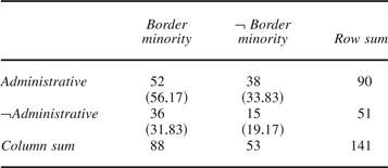
If we believe the claim that administrative borders are drawn in a way consistent with ethnicity, we would expect there to be some relationship between the choice of administrative borders and the existence of an ethnic population on the “wrong” side of the border. Thus, if it is indeed the case that the distribution of ethnic minorities is consistent with prior administrative borders, we should expect boundaries that follow administrative borders to be significantly less likely to create a border minority. We use data on the existence of a minority on the border from Huth and Huth and Allee.Footnote 68 Their variable takes a value of 1 if a minority within fifty miles of the border shares language or ethnicity with the largest group in the neighboring state and 0 otherwise.Footnote 69
We use the chi-square test of independence to assess whether the choice of administrative borders and the existence of a border minority are related. While the raw data in Table 3 do show a very slight trend in favor of the alternative explanation, the trend is not even close to conventional levels of statistical significance. With one degree of freedom, χ2 = 2.28, which is not statistically significant at either the 0.05 or 0.10 level. Thus, the data indicate that we cannot reject the null hypothesis that these two factors are independent of one another. Thus, the notion that administrative borders simply reflect the distribution of ethnic groups is highly suspect. Although we know that borders cannot perfectly separate ethnic groups, if this competing claim were correct we would at least expect to find a pattern in the data consistent with it. In a 1992 memorandum concerning the breakup of the former Yugoslavia, former European Community (EC) president Hans Van der Broek noted both the difficulty of drawing a border that separates ethnic groups and the inadequacy of the existing administrative borders relative to the distribution of ethnic groups. He noted that “it is impossible to draw Yugoslavia's internal borders in such a way that no national minorities would remain” while also lamenting the fact that “if the aim is to reduce the number of national minorities in every republic, better borders than the present ones could be devised.”Footnote 70 Our finding that it is not possible to reject the independence of these two factors lends general support to Van der Broek's observation that the existing borders in Yugoslavia did not do a very good job in separating ethnic groups.
Independence of administrative frontiers and border minority
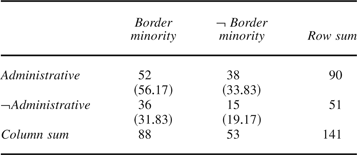
Note: Table notes observed values with expected values in parentheses.
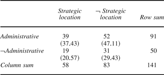
We assess the objection that administrative borders are drawn in a way that is consistent with military factors using a variable that assesses the strategic military value of territory near the border collected by Huth and Huth and Allee.Footnote 71 If administrative frontiers are drawn with reference to strategic military factors then we should expect these borders to be positively associated with the presence of strategically valuable territory.
We again run a chi-square test of independence to assess whether the process of drawing administrative borders is independent of military considerations. Thus, we use the numbers in Table 4 to assess the null hypothesis that administrative borders are drawn independently of the potential strategic and military value of the territory. With one degree of freedom, χ2 = 0.78, which is not even close to statistical significance at the 0.05 or 0.10 level. This more general finding is consistent with Sahlins's discussion of the military utility of natural frontiers along the boundary between France and Spain in the Pyrenees as negotiated in 1659–60. Sahlins notes that “natural frontiers, far from disguising strategic and military concerns, in the end determined such interests” and goes on to point out that “the French had won for themselves a military position that was to prove, in the next six decades, completely devoid of utility.”Footnote 72
Independence of administrative frontiers and strategic location
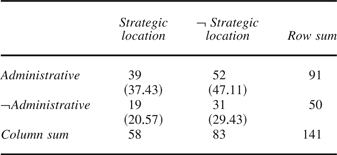
Note: Table notes observed values with expected values in parentheses.
Do Old Borders Make More Stable “New” Borders?
Above we argue that new borders with a precedent will be relatively more stable over time. We provide a simple test of this hypothesis here via empirical analysis of the relationship between how borders are drawn and the emergence (or re-emergence) of disputes over territory. To provide a difficult test, we only include transfers of territory via conflict and exclude secessions that are peaceful. Many of the secessions constitute peaceful transfers of territory (for example, Norway-Sweden 1905) and thus have a much smaller chance of future conflict.Footnote 73 We also include cases in which the drawing of a new border affects neighboring countries. For instance, in 1913 a transfer of territory from Turkey to Montenegro created a new international boundary between Montenegro and Serbia although Serbia did not technically gain or lose territory.
We use two related sets of data to assess the future stability of borders. First, we examine whether a new border subsequently becomes a formally disputed border. Data collected by Huth and Allee is nicely suited for this task, as they record the population of territorial disputes, violent and nonviolent, from 1919–95.Footnote 74 Second, we go one step further by assessing whether these territorial disputes become militarized disputes. Since Huth and Allee also record whether disputes escalate militarily, we rely on their data to assess whether territorial disputes escalate to militarized disputes.
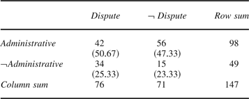
To assess the effect that states' choice of borders has on the outbreak of future disputes over the same border, we start by conducting a relatively simple test and move to more sophisticated assessments. First, we assess whether the process of choosing administrative borders or not is independent from the process by which subsequent disputes over territory emerge with a chi-square test of independence. Table 5 shows the distribution of the data across the four observable possibilities. The raw numbers suggest that administrative borders are more stable as forty-two out of ninety-eight cases (that is, approximately 42 percent) in which administrative borders are chosen become disputed borders, while thirty-four out of the forty-nine cases (that is, approximately 69 percent) in which administrative borders are not chosen are disputed. The chi-square test provides statistical support for the observed trend, as we find that with one degree of freedom, χ2 = 9.23, which is statistically significant at well below the 0.005 level.Footnote 75
2 × 2 contingency table
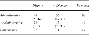
Note: Table notes observed values with expected values in parentheses.
Although we have established that these two factors are not independent of one another and can establish the direction of the trend from examination of Table 5, a regression model provides specific information about the magnitude of the effect and allows us to assume the relationship is conditional on a host of other important factors. The literature on territorial conflict demonstrates that several key factors play an important role in the emergence of territorial disputes. Specifically, whether border territory has strategic value, ethnic brethren, or economic value has been shown to have important effects on dispute emergence. When possible we use data collected by Huth or Huth and Allee for these variables and code the remainder ourselves.Footnote 76
The first two columns of Table 6 report the results of a logit regression model in which the presence of a subsequent dispute is the dependent variable and the independent variable is whether the newly drawn international border is a previously existing administrative border. The negative coefficient on the administrative border variable indicates that when a newly drawn border has a precedent, the probability that a dispute will emerge (or re-emerge) is diminished.
Logit model of the emergence of disputed borders variable

Note: Robust standard errors are in parentheses.
Columns (3) and (4) of Table 6 show that the negative and significant effect of the administrative border variable is robust to the inclusion of strategic location, economic value, and the presence of a border minority.Footnote 77 Out of the three territorial characteristics only border minority has a statistically significant effect. Thus, the presence of a minority population near the border with ties to the majority in the other relevant state is positively associated with the emergence of disputes. This result suggests that new borders that leave ethnic minorities in the “wrong” state are subsequently more problematic. While this result is both enlightening and concerning, it is not of much help in practice. As we point out in the first major section above, it is impossible in most cases to draw borders that perfectly separate ethnic groups. However, the choice of prior administrative borders is generally available to leaders and can decrease the propensity for disputes to emerge or re-emerge even in the tough cases when a minority will be left on the “wrong” side of the border.
We include four additional variables in our specification that are statistically insignificant. When both countries are democracies, or have a Polity score of at least 7 when the transfer takes place, there is a positive but insignificant effect on the propensity for a dispute to emerge (or re-emerge). Similarly, that territorial transfers include colonial holdings (for example, the transfer of Goa from Portugal to India in 1961) is not significantly related to whether there is a subsequent dispute. Additionally, the process by which boundaries are drawn can vary across cases, as sometimes negotiations are purely bilateral and at other times, great powers are directly involved (for example, the division of Korea in 1949). To account for this variation, we include a variable that indicates whether a great power was directly involved in the negotiations. The involvement of a great power has no influence on whether a dispute, violent or nonviolent, re-emerges. Finally, the length of the newly drawn border (in 1000s of kilometers) is also unimportant.
To account for the possibility that uti possidetis drives our results, columns (5) and (6) contain a third model that accounts for whether territorial transfers create a new state. The results are largely unchanged, although the administrative border variable becomes significant at the 0.10 level rather than at the 0.05 level. Interestingly, the new state variable is not significant, although the sign is negative. Thus, while our finding for administrative borders weakens slightly, the principle of uti possidetis does not appear to significantly depress the propensity for future disputes to emerge.Footnote 78
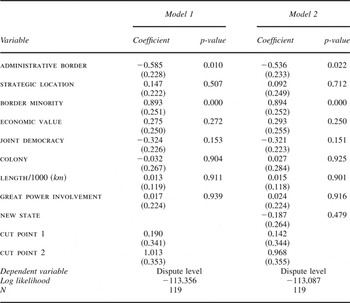
Since it has been established in the conflict literature that territorial disputes are especially violent,Footnote 79 the findings in Table 6 should have serious implications for how newly drawn borders affect the likelihood of militarized conflict. Thus, we explore the connection between how borders are drawn and the outbreak of militarized disputes over territory with an additional empirical model. We build on the empirical model shown in Table 6 with a model that also accounts for the outbreak of militarized disputes over territory. To do so we create an ordinal dependent variable that accounts for whether a dispute exists and whether it escalates to armed conflict. The ordinal dependent variable we analyze equals 0 if there is no territorial dispute, 1 if there is a dispute but it is not militarized, and 2 if there is a dispute and it is militarized. This ordinal variable allows us to straightforwardly extend the analysis in Table 6.Footnote 80
The results in Table 7 indicate that administrative borders depress both the emergence and military escalation of territorial disputes. Given that a large literature demonstrates how conflict over disputed territory is especially violent and protracted, this new finding is quite significant. Furthermore, the only other factor that matters is again whether there is a border minority, which still has a positive effect. Thus, the choice of administrative borders not only depresses the likelihood of future disputes over territory but also depresses the likelihood of violent disputes over territory. Borders that leave an ethnic minority on the “wrong” side of the border lead to an increased likelihood of both the emergence or re-emergence of a dispute and the outbreak of violence. Again, we point out that in practice it is nearly impossible to avoid boundaries that leave some people on the “wrong” side of the border. However, it is possible to choose administrative borders, which significantly reduces the probability that a violent dispute will emerge.
Ordered probit analysis

Note: Robust standard errors are in parentheses.
Model 2 accounts for whether a new state emerges as a result of the territorial transfer. Similar to our inclusion of a second multivariate model in Table 6, we include this variable to ensure that the principle of uti possidetis does not drive the results. The new state variable is again negative but insignificant and the findings of Model 1 are unaffected. Thus, the logic of uti possidetis does not appear to have much to do with the emergence of violent disputes following territorial transfers.
Although the findings in Tables 6 and 7 indicate that administrative borders significantly decrease the probability that disputes emerge and become violent, a demonstration that our findings are also substantively significant is still necessary. Table 8 shows the substantive effects that these two variables have on the onset of territorial disputes and the outbreak of violent conflict in the disputes.Footnote 81 The most violent combination is when the border does not have a precedent as an administrative line and creates a bordering minority. In this worst case scenario, the probability of a violent dispute is 0.411. If the new border has a precedent, this probability decreases by about 46 percent to 0.221, while the probability of not observing a dispute at all increases from 0.274 to 0.477. Thus, when new borders are previous administrative borders the probability that no dispute emerges is significantly greater. Furthermore, if a dispute does emerge, it is much less likely to escalate militarily. The other findings in Table 8 further reinforce this observed trend. If the new border does not create a bordering minority in either state and is not a prior administrative border, the probability of seeing a violent conflict is 0.130, which is not a negligible probability. If the border has a precedent, the probability of seeing a violent dispute decreases to 0.048, while the probability of seeing no dispute at all increases from 0.617 to 0.798. Thus, the choice of a prior administrative border decreases the probability that a dispute over the border arises and makes any such dispute significantly less likely to become violent. Table 8 demonstrates that this holds regardless of whether the new boundary places a minority population on the “wrong” side of the border.
The emergence of nonviolent and violent disputes

Conclusion
How new borders are drawn is one of the most overlooked aspects of international relations today but underlies the territorial order of the international system.Footnote 82 How new borders are drawn, we show, fundamentally affects the probability of the emergence or re-emergence of territorial disputes between neighbors. To come to this conclusion, we make both theoretical and empirical contributions. First, conceptualizing borders as institutions, we argue that prior administrative borders are likely to form the basis of new international borders, not least because prior administrative boundaries are likely to be much more stable and effective in reducing the probability of future conflict. To assess our claims, we collected new data on how borders were drawn following secessions and conflictual transfers of territory in the twentieth century. We find that in the great majority of cases, new international borders were drawn along previous administrative boundaries. We combine our new data with existing data on territorial disputes to demonstrate that the way in which borders are drawn has a significant effect on the probability that future disputes and militarized conflicts arise over the border. In short, when boundaries follow prior administrative frontiers, both nonviolent and violent territorial disputes are less likely to arise.
This article opens up many avenues for fruitful future research. We discuss two related projects here. First, our theoretical framework has important implications for the study of trade flows. Simmons finds that clearly established borders have significant influence on states' economic well-being via trade.Footnote 83 We build on the analysis in this article to show that the manner in which new borders are drawn has implications for states' economic interactions as well. Preliminary findings suggest that while new borders between states disrupt the volume of bilateral trade, new borders that follow prior administrative frontiers do so to a much lesser extent. Thus, the way a border is drawn has significant influence on the economic realm as well as the security realm (as demonstrated above).
Second, our framework provides important insight into why states typically demand very specific discrete pieces of territory in international territorial disputes. While authors such as Murphy note that “the justifications now offered in support of territorial claims are almost invariably couched in terms of recovery of territory that historically belonged to the claiming state,” no broad empirical evidence has ever been provided on this front.Footnote 84 In a future project we will probe in more detail whether territorial demands are systematically framed in terms of specific administrative units. If this is indeed a general phenomenon, it has the potential to provide a convincing explanation for why disputes over territory are particularly violent. In short, if territory is indeed a “lumpy” good, as our framework implies, the influential bargaining model of war suggests that this can increase the probability of armed conflict.Footnote 85 This is significant as the relative violence of territorial disputes is widely demonstrated empirically but is without a widely accepted explanation.Footnote 86
Finally, our research suggests the importance of “middle-range theorizing.”Footnote 87 We first established and explained a new source of “middle-range” variation, and then used this variation to explain the probability and severity of territorial conflicts. In the process, we addressed an issue of long-standing concern to policymakers and showed their concern was justified: how and where borders are drawn does indeed significantly affect the probability and severity of future conflict. We believe that the concerns of policymakers can lead to similar sources of relatively fine-grained variation, which produces puzzles interesting in their own right, and might lead to new answers to old problems.