Introduction
The areal coverage of mangroves in India is estimated to be 4827 km2, accounting for about 5% of the world's mangrove vegetation and 0.4% of the geographic area. About 46 true mangrove species are reported from India (Ragavan et al., Reference Ragavan, Dubey, Dagar, Mohan, Ravichandran, Jayaraj and Rana2019). The diversity and size of the mangroves are less on the west coast of India compared with the east coast, a consequence of the difference in geomorphology of the two coasts (Selvam, Reference Selvam2003). Reporting of rare mangrove species is very important for ecosystem studies and conservation (Goutham Bharathi et al., Reference Goutham Bharathi, Kaliyamoorthy, Dam Roy, Krishnan, George and Murugan2012), Kandelia candel (K. candel) is one of the rare mangrove species belonging to the family Rhizophoraceae, found in Indian coastal states with limited distribution. The genus Kandelia is represented by two species, viz. K. candel and K. obovata. The former is distributed continuously along the west coast of India from south up to Gujarat, but found only in West Bengal, Orissa and Andaman Nicobar Islands (ANI) on the east coast. Kandelia candel has also been reported from various East Asian countries such as Myanmar, Malaysia, Singapore, Indonesia and Philippines (Sheue et al., Reference Sheue, Liu and Yong2003b). Genus Kandelia was present in Sri Lanka (Rao, Reference Rao1987), but later Jayatissa et al. (Reference Jayatissa, Dahdouh-Guebas and Koedam2012) confirmed the complete disappearance of Kandelia from Sri Lanka.
In India, the occurrence of K. candel in the ANI was confirmed by Jagtap (Reference Jagtap1985), but in his subsequent publication (Jagtap, Reference Jagtap, Suryanarayan and Sudarsen1994), he noted that K. candel had disappeared completely from the Andaman Islands. The absence of this species in Andhra Pradesh lying close to West Bengal and rich in mangroves was a question of curiosity until Krishna Rao & Ramasubramanian (Reference Krishna Rao and Ramasubramanian2013) observed a few plants of K. candel from Nellore district. Recently Pandey et al. (Reference Pandey, Pandey, Khokhariya and Mali2009) reported for the first time a single plant of K. candel from Gujarat, north of Maharashtra on the west coast. Thus, the mangrove is noted for its ecological sensitivity and thereby sporadic presence and disappearance all along the Indian coast. In the light of available information on the distribution of the species, the sighting of a single plant of the species in Andhra Pradesh during our study holds great relevance and calls for detailed analysis. This paper describes the first record of this species during the taxonomic and ecological study of mangroves carried out in all 41 patches of Andhra Pradesh. The confirmation of the taxonomic identity of the obtained specimen was carried out using morphological and molecular methods.
Materials and methods
Study area
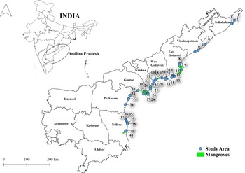
Andhra Pradesh is a coastal state situated on the eastern coast of India. There are nine coastal districts and four non-coastal districts. The state has a widespread coverage of mangrove forest. Andhra mangroves are distributed in eight coastal districts with an area of around 367 km2 (FSI, 2015) which is about 7.74% of total mangrove coverage of India (Figure 1).
Map showing the distribution of mangrove and the study sites in Andhra Pradesh.

Methodology
Distribution of mangroves was studied using the belt transect method (Haryuni et al., Reference Haryuni, Harahap and Setyohadi2014) in all the 41 mangrove patches in Andhra Pradesh (Figure 1). The different species and their number from each transect and quadrate were noted and photographed. Detailed information on morphological characteristics was compiled and the location of collection was mapped using QGIS. The collected plants were identified using standard identification keys (Tomlinson, Reference Tomlinson1986) and manuals (Dam Roy et al., Reference Dam Roy, Krishnan, George, Kaliyamoorthy and Goutham-Bharathi2009). A single specimen morphologically similar to K. candel was observed during the survey from Bhavanapadu (18.55°N 84.31°E) on 18 October 2015. Since the species had not been reported from this location earlier, we collected the vegetative parts, preserved them for the herbarium and deposited them in the CMFRI designated national repository (accession number: MB.1.1.1.1).
Leaf samples of the plant were collected for DNA isolation. Molecular identification and barcoding were done by extracting the genomic DNA from the leaf tissues using CTAB Buffer method and generating partial sequence information of 466 base pairs. Approximately 30 μl reaction mixture was prepared with Dream Taq green master mix and ribulose biphosphate carboxylase F (rbcLa F) and ribulose biphosphate carboxylase R (rbcLa R) primers (Levin et al., Reference Levin, Wagner, Hoch, Nepokroeff, Pires, Zimmer and Sytsma2003). PCR reaction was performed in thermal cycler (ABI proflex PCR system) at 98°C for 45 s; 35 cycles at 98°C for 10 s, 55°C for 30 s, 72°C for 40 s; final extension at 72°C for 10 min. The DNA sequencing was done by Sanger sequence method and the sequences compared with the existing sequences of the same species using Basic Local Alignment Search Tool. The phylogenetic studies were conducted using the Jukes-Cantor model in MEGA 7 software (Tamura et al., Reference Tamura, Stecher, Peterson, Filipski and Kumar2013). The sequences of the specimen plant were compared with the sequences of same species collected from India and the other parts of the world that are available in NCBI GenBank.
All the mangrove plants counted during the field surveys along the 41 patches in Andhra Pradesh were subjected to statistical analysis using Primer (Version 6.0). Principal component analysis (PCA) was carried out to understand the statistical significance of all the 41 mangrove patches to understand the uniqueness of patch 2 (where K. candel was reported) in the study area. Google earth historical image data based on Landsat satellite were collected from Google Earth Pro to distinguish the changes in land cover in the study area in the recent past.
Results
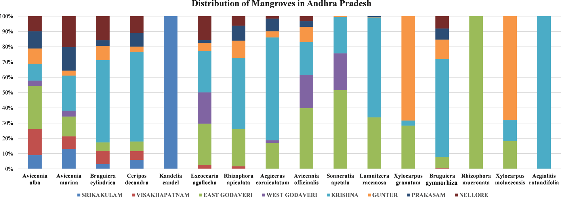
Mangroves of Andhra Pradesh are distributed in eight coastal districts starting from Srikakulam in the north to Nellore in the south. Sixteen mangrove species (Figure 2) were observed during the study. Acanthaceae was the dominant mangrove family and Avicennia the dominant genus in the 41 patches surveyed. Rhizophoraceae and Euphorbiaceae are the other dominant mangrove families in the state. Among all the mangrove species, Aegialitis rotundifolia and K. candel were rare, but Aegialitis rotundifolia was represented by more than one plant in the Krishna District of Andhra Pradesh. The presence of only one plant of K. candel was found in the Srikakulam district of Andhra Pradesh. The rare occurrence of K. candel was subjected to further analysis to understand the significance of the presence of only one plant in the state.
Percentage distribution of all mangrove species in the eight coastal districts of Andhra Pradesh.

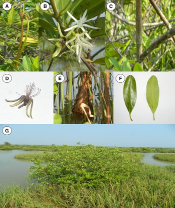
The identified mangrove K. candel was a 3–5 m long plant that could be classified either as a tree or shrub. The bark was greyish in colour with numerous lenticels. Leaves were light green; opposite, oblong-elliptic with 8–10 lateral veins. Flowers were white, 1.5–2 cm long, 4–9 in axillary cymes. Calyx lobes linear, acute. Petals are bifid. Fruits were green and brown in colour and 25–30 cm in length. The morphology of the stipules and leaves of K. candel resembled those of other Rhizophoracean genera such as Bruguiera, Ceriops and Rhizophora (Figure 3) (Sheue et al., Reference Sheue, Liu and Yang2003a).
Photographs of Kandelia candel with its vegetative parts. (a) Berry. (b & d) Flower. (c & e) Bark. (f) Leaves – dorsal and ventral sides. (g) Habitat.

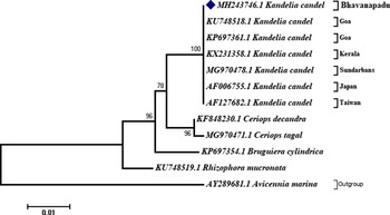
Molecular studies based on 466 bp edited and aligned sequence of rbcLa gene revealed that the specimen had 100% similarity with the globally existing K. candel databases. The sequences obtained were deposited online in the National Centre for Biotechnology Information (NCBI) depository (accession number MH243746). The phylogenetic tree showed similarity with existing and reported K. candel sequences from other parts of the world (Figure 4). Sequences for the same species from South East Asian countries were not available in NCBI. Therefore, available sequences of the same species from Taiwan and Japan were also included in the phylogenetic tree. The intra-species genetic distance between the plants from Indian origin and Pacific Ocean region plant sequences is 0.2%. Among the other members of Rhizophoraceae family, Ceriops tagal showed the closest similarity with K. candel, followed by Rhizophora mucronata and Bruguiera cylindrica. Neighbour-joining molecular phylogenetic analysis based on partial sequence of rbcLa gene (466 base pairs) confirmed that all the K. candel species in the Indian coast are of the same population without any haplotype variation. The collected sequences from NCBI from the south-east and north-east regions of the Indian Ocean were found to be from the same genetic stock.
Neighbour-joining tree generated based on our sample (accession no. MH243746) in comparison with the other K. candel specimens from Kerala, Goa, Sundarbans, Japan and Taiwan in secondary databases as well as with other members of Rhizophoraceae family. Avicennia marina belonging to Acanthaceae family was used as outgroup.

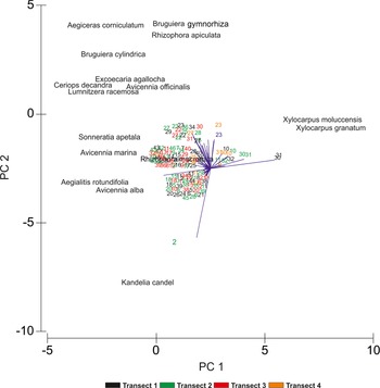
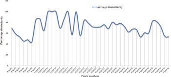
All mangrove plants counted during the field surveys were subjected to Principal Component Analysis (PCA) to understand if the distribution of K. candel was different and formed a separate cluster from the other mangroves of all the 41 patches (Figure 5). From the analysis, it is evident that transect 2 of mangrove patch 2 in the Srikakulam district is separated away from the other clusters in the principal component one (PC1). This distinctness from other patches is possibly due to the occurrence of K. candel in patch 2 (transect 2) alone. The average dissimilarity among the other mangrove patches in the state (Figure 6) with mangrove patch 2 revealed that patch 2 shows an average dissimilarity of about 71.79% from the other patches, possibly this also could be due to the occurrence K. candel in patch 2. The dissimilarity of mangrove patch 2 with all other patches is also provided (Supplementary material S2).
PCA to assess the significance of mangrove patches in Andhra Pradesh. The presence of Kandelia candel is seen only in patch 2.

Average dissimilarity of mangrove patches in Andhra Pradesh with patch 2 where K. candel was observed.

Discussion
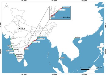
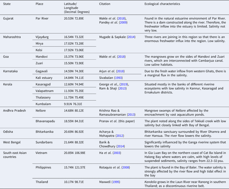
The distribution of K. candel on the west and east coasts of India is well documented (Table 1). On the west coast, the plant is found along the coast of Gujarat to Kerala (George et al., Reference George, Krishnan, Mini, Salim, Ragavan, Tenjing, Muruganandam, Dubey, Gopalakrishnan, Purvaja and Ramesh2019), whereas along the east coast of India, confirmed existence of Kandelia has been reported only from West Bengal, Orissa and ANI. There is no documented evidence for the occurrence of the plant in Tamil Nadu and the only record of K. candel from Andhra Pradesh is that of Krishna Rao & Ramasubramanian (Reference Krishna Rao and Ramasubramanian2013) of a few plants from Nellore district which is in the southern tip of Andhra Pradesh state. Ragavan et al. (Reference Ragavan, Dubey, Dagar, Mohan, Ravichandran, Jayaraj and Rana2019) have reviewed the status of mangrove density in the east coast of India and have confirmed the low abundance of the species in the east coast. Whereas, the region in which we spotted the plant is in the northern region of Andhra Pradesh. The east coast of India is ~2300 km long (Figure 7) and there is a huge data gap for the occurrence of this mangrove plant in that region. However, their identification was solely based on morphological features; whereas ours is a 100% confirmed identification based on molecular DNA analysis (Figure 4).
Map of the distribution pattern of K. candel in India and south East Asian coastal region (dark green dots). Dark green dot denotes the location of the present study from where the mangrove plant was identified. Red line indicates the distance between the two points in the east coast of India where the mangrove has never been reported prior to the present study.

Ecological characteristics of Kandelia candel reported from various locations in India and South East Asian countries

Andhra Pradesh is known for its rich diversity of mangroves, with most of them located along the estuaries of Godavari and Krishna rivers i.e. in East Godavari, Krishna and Guntur districts. Apart from these, mangroves are also found as small patches along the coasts of Visakhapatnam, West Godavari and Prakasam districts. From the many records of mangroves of Andhra Pradesh available (Ramasubramanian et al., Reference Ramasubramanian, Ravishankar and Sridhar2003), except for the one by Krishna Rao & Ramasubramanian (Reference Krishna Rao and Ramasubramanian2013), no mention is found regarding K. candel. The 41 mangrove patches examined throughout Andhra Pradesh show that nearly 40% of mangrove flora belongs to Avicenniaceae family followed by Rhizophoraceae. Even though a member of the Rhizophoraceae family, K. candel was not found anywhere else in the state, other than the single plant obtained from one of the patches in Bhavanapadu.
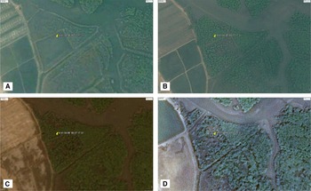
The lone K. candel plant that we obtained was located along the bank of a low-salinity creek in Bhavanapadu, the Tekkali creek, which is isolated from the nearby salt pans and aquaculture ponds by means of physical barriers (roads). The salinity of the study area where freshwater canals join the creek was in the range of 5–22 psu (Kurapati et al., Reference Kurapati, Dogiparti and Duddu2016). The low saline area with good river discharge, small tidal influx and muddy soil might have been conducive for the growth of K. candel in Bhavanapadu. Compilation of the ecological preferences of K. candel (Table 1) from India as well as some SE Asian countries (Figure 7) corroborates this. The intriguing factors are the existence of a single plant of the species in the area and its failure to establish a colony. According to Sivabalan (Reference Sivabalan1993), the distribution of mangroves are strongly influenced by ecological characteristics. The zonal distribution of mangroves generally follows salinity variations. Kandelia candel is usually found in less saline areas. Long-living propagules help in distant area dispersal of these plants, amply supported by ocean currents. But environmental conditions determine whether the particular species can colonize in areas where they are deposited. Isakapalle region of Nellore district of Andhra Pradesh was the place from which Krishna Rao & Ramasubramanian (Reference Krishna Rao and Ramasubramanian2013) reported the occurrence of K. candel in the state in 2013. Extensive survey in the same locality was conducted as part of our fieldwork in 2015, but the plant was not found in that locality. Proliferation of aquaculture farms and salt pans leading to saline water intrusion into the area would have led to the destruction of the plant. To confirm that mangroves in the area were destroyed, we compared Landsat satellite-based Google Earth images (Figure 8) during 2009–2014. A marginal decrease in the mangrove distribution in that region over 2013–14 was very evident, which could have been due to either saline water intrusion or cutting off of mangroves for setting up aquaculture farms.
Landsat satellite-based Google Earth images demonstrating the status of mangroves in Iskapalle region of Andhra Pradesh over four different years. (A) 2009: non-mangrove site. (B) 2010: occurrence of mangroves as a patch. (C) 2013: increased distribution and density in mangroves (K. candel reported during same time). (D) 2014: loss of mangroves due to either saline water intrusion and aquaculture expansion.

The reports of the few scattered plants of K. candel from Gujarat and Nellore support the view that the mangroves may reach hitherto uncolonized locations through the water but may not be successful in establishing a colony if the environmental conditions are unfavourable. Reports on disappearance of the plant from ANI (Jagtap, Reference Jagtap, Suryanarayan and Sudarsen1994) and Singapore (Yang et al., Reference Yang, Lim, Sheue and Yong2011) confirm this view. Further, the mention by Hoque et al. (Reference Hoque, Sarkar, Khan, Moral and Khurram2006) that even germination of seeds of some halophytes is dependent on a certain level of salinity, and that there is an optimum salinity range for maximum growth of different mangrove species is of relevance here. In the present case the lone plant has been identified from an area surrounded by salt pans and aquaculture farms. Fortunately, the continued presence of the same plant and two new seedlings was observed in August 2016 during another field survey (Supplementary Figure S1) despite the threats the mangrove is facing. The contamination of ground water in the vicinity by high saline water leaching from the salt pans could inhibit the colonization attempts by this salinity sensitive plant. Another argument that can be put forth is that the local community is ignorant about the evolutionary significance and rarity of the mangrove species and the common practice of cutting down overgrown mangroves for aquaculture purposes might have reduced it to a single member and two seedlings in the vicinity. The phylogenetic analyses using the sequences of K. candel from Indian states of Kerala and Goa, as well as those from Sunderbans, Taiwan and Japan showed that they were identical to the sequences of the plant obtained from Bhavanapadu. This indicates a possibility that the propagules of the plant might have drifted to Bhavanapadu from any of these regions.
In India, the complete cataloguing of mangrove species has not yet been done, due to lack of comprehensive compilation and extensive field surveys (Kathiresan, Reference Kathiresan2010). Kandelia candel is a rare and threatened true mangrove species at the extremities of its range (IUCN, 2008). Bhavanapadu wetland is an area rich in mangrove-associated flora and fauna, including bivalves, crabs, spotted-billed pelicans, painted storks and even migratory flamingos (Mathew et al., Reference Mathew, Arun, Murugesan and Arthi2012). Modifications to the Bhavanapadu wetland may adversely affect the survival of this species. Our observation during the study was that the local population was ignorant about the ecological value of the mangroves, which were being cleared for shrimp farms, fish ponds and salt pans. Continued monitoring and research, in tandem with conservation measures, are recommended for sustenance of biodiversity, and protection of rare mangrove species.
Apart from the ecological benefits, the bioactive compounds derived from certain mangrove plants have antibacterial (Kokpol et al., Reference Kokpol, Chittawong and Mills1984) and antiviral properties (Padmakumar et al., Reference Padmakumar, Ramaswamy, Ayyakkannu and Nair1993) that have been used to develop medicines to treat a variety of diseases and illnesses, including diarrhoea, diabetes, ulcers, asthma, cancer etc. (Bandaranayake, Reference Bandaranayake1998). Condensed tannins from Kandelia candel were extracted to use as potential antioxidants (Zhang et al., Reference Zhang, Lin, Zhou, Wei and Chen2010). Kandelia candel and Kandelia obovata are known to produce secondary metabolites derived from isoprenoid and phytosterol (Basyuni et al., Reference Basyuni, Baba, Oku, Mulia and Bimantara2019). These exhibit the value of Kandelia candel as well as its ecological significance.
Conclusions
A single specimen of K. candel was observed for the first time in the Bhavanapadu region during our exploratory survey covering all the 41 mangrove patches in Andhra Pradesh, India. This mangrove is identified and confirmed using both morphological and molecular techniques. Molecular analysis showed 99% similarity with the existing species libraries of K. candel. Statistical analyses using PRIMER revealed the significant dissimilarity of the patch containing K. candel with the rest of the 40 patches and the occurrence of patch 2 containing the plant as a separate cluster in PC1, with the patch showing an average dissimilarity of about 71.79% from the other patches. The continued presence of the same plant with two seedlings was re-confirmed in August 2016 during another field survey. But the identified plant was located in an area of aquaculture ponds and salt pans with high chances of destruction. Therefore, proper awareness should be created among people not to alter the ecology of the area for human benefits and that cataloguing and monitoring the mangrove diversity is essential to sustainably manage these critical habitats from anthropogenic intrusions. Mangroves are among the most degraded and vulnerable ecosystems along the coast, and they must be conserved before they vanish from the world. The existence of a single individual of a state-wide uncommon species at the sampling site raises hopes that the species is still present but at the same time we are concerned about the loss of an earlier sighted plant in the state (Krishna Rao & Ramasubramanian, Reference Krishna Rao and Ramasubramanian2013) which necessitates protecting the state's mangrove vegetation with special reference to Kandelia candel. The study also suggests using a similar strategy to explore and locate rare mangrove species in other parts of India in order to sustain and conserve the country's dwindling mangrove flora.
Supplementary material
The supplementary material for this article can be found at https://doi.org/10.1017/S0025315422000947.
Data
The data that support the findings of this study are available from the corresponding author, Grinson George, upon reasonable request.
Acknowledgements
The first author is grateful to the funding agency, National Centre for Sustainable Coastal Management (NCSCM) for financial support and to the Director, Central Marine Research Institute (ICAR-CMFRI) and Scientist-in-charge of the ICAR-CMFRI Regional Centre, Visakhapatnam. He is also thankful for the support received from the fellow scholars in the NCSCM project during field survey and analyses. This manuscript is part of the ongoing PhD work of the first author in Andhra University.
Author contributions
P. Pranav: Carried out field sampling and analysis – wrote the MS; Grinson George: Project conceptualization – mentoring – fund management-project implementation – data management – manuscript revision and correspondence; R. Ranith: Carried out statistical analysis, revision of manuscript; Nandini Menon N: Editing – revision of the manuscript and technical support – coordination of this work among authors; A. Gopalakrishnan: Coordination of the project – project management-manuscript revision and coordination in the Institute; Shameem U.: Mentoring the student – work conceptualization – supervision and editing.
Financial support
The research work was funded by the National Centre for Sustainable Coastal Management (NCSCM), Chennai, under the Ministry of Environment, Forest and Climate Change (MoEF&CC), Government of India.
Conflict of interest
The authors declare no conflict of interests.