Introduction
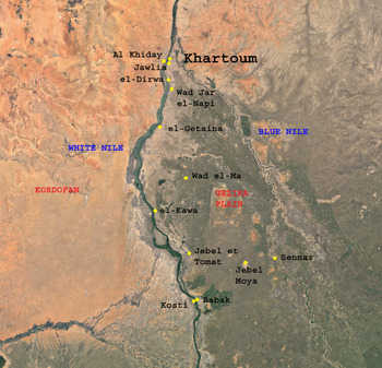
Limited archaeological surveys and small-scale excavations up the White Nile (south of the 6th Cataract near Khartoum; Figure 1) have occurred over the past one hundred years. Numerous materials dated to the Meroitic period (c. 350 BC–AD 350) have been found. These finds include pottery, gold-bronze-iron metal objects, faience beads and scarps, arrow heads, spearheads, archers’ equipment, and figurines (human and animal). While stone structures such as temples are not found up the White Nile, the investigations to date have not looked for structures made from perishable materials such as mud brick. Mud buildings in the region collapse with the rains and the areas are reduced to smooth, dome-shaped mounds. Such mounds are visible in south-central Sudan, including along the White Nile. Likewise, although encompassing many areas upstream, the finds have tended to be published in isolation and no attempt has yet been made to explain why these items are present and what they may be able to illuminate about the influence of the Meroitic state south of its heartland between the 5th and 6th Nile Cataracts.
Location of Meroitic sites referenced in the text.

Here, a fresh look is taken at the data from these past surveys and small-scale excavations, and integrates it with the only real new data arising from Donatella Usai and Sandro Salvatori's excavations at Al Khiday to question whether or not Meroitic political control extended up the White Nile. It is first hypothesized that there was no direct Meroitic political control: the structures making up the political and religious centres north of the 6th Cataract up to the Egyptian border are not present along the White Nile. What the data appears to suggest is that there was a diffusion of Meroitic trade, traders, small-scale population movements, and indirect influence. The added presence of burials, contemporary with the Meroitic state, either isolated or in small-scale cemeteries may attest to the existence of mobile communities practising hunting-fishing or pastoralism, or a mix.
Overview of the study area
Geographically, the White Nile region (latitude 13°58′37″ N to 15°14′29″ N and longitude 31°54′38″ E to 32°53′50″ E) lay in the former south-central of the old Sudan, before the separation of 2011 into Sudan and South Sudan. Now, it is the southern part of the Sudan, located between Sudan and South. With an official population of 1,717,000, its two major cities are Kosti and Rabak (Figure 1). The former is the economic centre, while the latter is the capital of the state (Yousif and al-Toam Reference Yousif and al-Toam2008, 13–14) which encompasses about 500 km² north to south and about 170 km² east to west. The name of the region is derived from the White Nile as a main topographical feature in the Sudan, which divides the region in two parts (Mahmoud et al. Reference Mahmoud and Obeid1971, 153); the eastern bank connects with the el-Jazeera region, and the western bank with Kordofan.
There are several cultural groupings who live in the area of White Nile. Their densities vary according to place. They encompass people of Arab, West African, and Nilotic descent. Those of Arab descent cultivate domesticated sorghum and raise livestock, mainly cattle and sheep, which feed on the scanty vegetation during and shortly after the summer rainfall season and on the remains of the crops after harvest. The other groups engage mainly in fishing, trade, and making of handicrafts. The majority of the population in the region outside of the urban centres are agro-pastoralists who reside in mud hut villages, along the main roads on the sides of the White Nile, and who otherwise engage in petty trade, seasonal labour, and government employment.
The population growth rate in the Sudan has necessitated an increase in food crop production. The increased use of irrigation and the mechanization of small-hold and large-scale agricultural estates has brought about an expansion of land under cultivation. Similar to well-documented occurrences in Egypt, such expansion with scarce available land resources has had an impact upon both the ecology and the preservation of archaeological sites, and therefore the mapping of their occurrences prior to heavy disturbance or destruction. Where localities have been excavated, it has been piecemeal and development work is encroaching on them (e.g. Kosti).
The ecology of central and southern Sudan
According to Andrew (Reference Andrew and Tothill1948), the Sudan is divided into six main geological units. For the White Nile region, there are three highly important units to consider. The first unit is the windblown sand and superficial gravels, which are especially prevalent on the western bank of the White Nile. Along the northern part of the White Nile, the unit represents the youngest cover of the area comprising as it does sedimentary deposits which are either still being formed today or are of relative recent origin. To the west of the White Nile and the main Nile occurs an ancient long, narrow belt of sand known as Qoz Abu Dulu. The belt widens to as much as 93 km west of Kosti (313 km south of Khartoum) to Tandelti, with interplay between the sand belt and the Nile drainage (Vail Reference Vail, Williams and Adamson1982, 51–63).
The second unit is the clay silts to the east of the White Nile overlying the Gezira Plain and forming part of the uppermost layers of the Umm Ruwaba Formation Type (an unconsolidated aquifer) to the south. The silts and clays of the el-Gezira formations are comparable to the Umm Ruwaba formation to the west (Edwards Reference Edwards1989, 40). The third unit is the Basement Complex comprised of metamorphosed and igneous rocks (Vail Reference Vail, Williams and Adamson1982). Inselbergs such as the Jebel Moya massif are granitic outcrops of the Basement Complex breaking through the sandstone overlay. The Basement Complex contains an underground aquifer, resulting in fresh water rising to ground level surface around the bases of outcrops. This is particularly important in a plain without permanent surface water for maintaining animal herds. The underground aquifer is replenished by the waters from both the Blue and White Niles. Indeed, the fertile Gezira (Arabic for island) is a megafan built by the Blue Nile and crisscrossed by Late Pleistocene and Early Holocene channels (Williams Reference Williams2009, 7). Examples are the depressions and sandy ridges of Palaeo-channels fanning out to the north and north-west from the area around Sennar (Mubarak et al. Reference Mubarak, Bari, Wickens, Williams, Williams and Adamson1982, 179; Williams Reference Williams, Williams and Adamson1982, 113). Overlaying the sandstone formation in the Gezira are dark alkaline cracking clays, while sandy loams and clays and recently deposited alluvial sands are observed along the banks of the White Nile (Obeid et al. Reference Obeid, Bari, Wickens, Williams, Williams and Adamson1982, 151).
Vegetation
The White Nile region is characterized by three main seasons: warm winter from October to February, hot dry summer from March to June, and hot rainy summer from July to September. The modern ecology is determined not only by the rainfall and soil types (Obeid et al. Reference Obeid, Bari, Wickens, Williams, Williams and Adamson1982, 143), but also by biotic factors such as grazing, cutting, burning, and cultivation. The vegetation along the northern White Nile, approximately between Khartoum and el-Dueim, belongs to the semi-desert scrub and grasslands with a mixture of grasses and herbs. The remainder of the Gezira Plain exhibits three major vegetation units, in relation to rainfall: semi-desert scrub, semi-desert grassland on clay, and Acacia mellifera thorn-land (Obeid et al. Reference Obeid, Bari, Wickens, Williams, Williams and Adamson1982, 150). The acacia thorn-land lies south of the line joining Tagra and Wad Medani, and extends southwards to an imaginary line joining Kosti on the White Nile, Jebel Moya in the middle and Sennar along the Blue Nile (Obeid et al. Reference Obeid, Bari, Wickens, Williams, Williams and Adamson1982, 151).
Exploration overview
There are several possible reasons why the Gezira Plain and the White Nile have not seen extensive or systematic modern archaeological works, apart from Al Khiday, Jebel Moya and Rabak, particularly in relation to exploring the nature of Meroitic contact. First is the lingering influence of Egyptology and rescue archaeology which prioritized work in Nubia. A second was the focus on the royal heartland of Meroe in the central Shendi Reach. Another reason is more political, namely the lack of exploring the identity of the people of the Gezira further back than the early Islamic states. In terms of physical investigation, there are obstacles. There is seemingly a low density of Meroitic-era settlements and remains outside of places such as Al Khiday and Jebel Moya, but this is much more likely due to the lack of systematic intensive survey work.
Such surveys are urgently needed before increasing urbanization and population numbers irreparably harm the archaeological landscapes. The issue of preservation of mud brick structures was highlighted earlier. Consequently, the information from the region on its cultural connections with the Meroitic heartland has been ignored until recently (Usai et al. Reference Usai, Salvatori, Jakob and David2014; Brass Reference Brass2015). The majority of the fieldwork undertaken has focused on older periods, natural history and geology. Often, many of the discoveries datable to the Meroitic and post-Meroitic time periods come from excavations where the primary focus was on earlier periods, for example the sites of Shabona and Jebel et Tomat (Clark Reference Clark1973). Nevertheless, the explorations can be divided into distinct phases.
The early explorations
Salem Gob tan's expedition was the first and only attempt at exploring the area in the middle nineteenth century. It was commissioned by the Ottoman governor of Egypt, Mohamed Ali Basha, with the aim of documenting the natural and human resources of the White Nile. Salem started his journey from Khartoum in Reference Salem1839, sailing upstream. He particularly recorded the names of islands, village communities, jebels (mountains), plants and riverine and land animal life.
Despite Salem's rich descriptions, the mission's drawback was that none of its members had knowledge of the local languages. This resulted in wrong names repeatedly given for places and villages. Subsequently, many of the present-day towns were built. Still, Salem's record includes some villages which have survived into modern times, such as el-Showal and el-Jazeera Mosran.
Twentieth-century explorations
It was only one century later that the next exploration occurred, in the form of an archaeological mission by A. J. Arkell, the director of the Sudanese Antiquities Authority, in 1939. He carried out a series of excavations around Kosti, which yielded remains datable to the early Meroitic period (Arkell Reference Arkell1950, 40). These finds include pottery sherds as well as a scrap amulet whose date of origin was late Napatan. The finds are curated in the Sudan National Museum and are still amongst the earliest evidence for contact with the Meroitic state to the north.
In 1953, the Sudanese Antiquities Authority under Marshall and Adam (Reference Marshal and Adam1953, 140) excavated el-Ushra on the western bank of the White Nile south of Omdurman. Skeletal remains in contracted positions were found in mound graves dated to the Meroitic and post-Meroitic. At the same time, Crawford (Reference Crawford1953, 26–27) excavated the site of el-Getaina, where he registered some Meroitic pottery sherds and foundations made of red brick dating to the early Christian period. There are also odd Meroitic objects which have been brought to the attention of researchers by villagers.
Later, J. Desmond Clark sunk test trenches at Jebel et Tomat (Clark Reference Clark1973; Clark and Stemler Reference Clark and Stemler1975), situated near the east bank of the White Nile to the north-east of the famous site of Jebel Moya, which is in the middle of the southern Gezira Plain (Addison Reference Addison1949; Brass Reference Brass2016). Jebel Tomat was a multi-phase site. The earlier phase was radiocarbon dated to the mid-third millennium BC, on the basis of a single date from a freshwater shell obtained from a pit dug at the edge of a surface-observed midden and in uncertain association with cultural materials. The thick everted, chevron-decorated pottery sherds from this phase are similar to the Assemblage 2 sherds from Jebel Moya (Clark and Stemler Reference Clark and Stemler1975; Brass Reference Brass2016). The later occupational phase is dated by five conventional radiocarbon dates to between the early first and the end of the fourth centuries AD Clark and Stemler Reference Clark and Stemler1975, which is contemporary with the third occupational phase at Jebel Moya (Brass Reference Brass2016). Domesticated sorghum is present during this phase at Jebel et Tomat, which indicates a mixed economy together with domesticated cattle bones.
Lastly, Randi Haaland and Ali Tigani el Mahi (Reference Haaland1984) conducted an archaeological survey from January to February 1983 between Jebel et Tomat and Rabak. Rabak was selected for excavation out of five candidate localities. The cultural deposits extend over an area of c. 200 × 80 m of the midden situated c. 3 km to the east of the current course of the White Nile. Test excavations occurred in the centre and the outer limits of the midden, encompassing c. 18 m2 . Depth averaged 50–80 cm, with the uppermost being 150 cm in an area used as a kitchen refuse disposal (el-Mahi and Haaland Reference Haaland1984, 28). However, crucially ‘the cultural deposit showed no stratification and arbitrary levels of 10 cm were employed’ (el-Mahi and Haaland Reference Haaland1984, 28). Unfortunately, there are no published reports on what constituted the likely Meroitic remains in the uppermost spits.
Research undertaken into and during the twenty-first century
The period between the end of the twentieth century and the present has seen two major archaeological expeditions in the White Nile region and accompanying comparatively lesser surveys. The first was an archaeological survey on the eastern bank of the White Nile by K. Eisa (Reference Eisa1997, Reference Eisa2004). Begun in 1997, it was supported by the National Corporation for Antiquities and Museums (NCAM) and the University of Khartoum. Its aim was to map and determine the nature of archaeological settlements, ascertain the southern extension of the Napatan and Meroitic states and present proposals on the safeguarding of endangered sites (Eisa Reference Eisa2002). This was the first project to document and record, as well as map, the sites’ locations by GPS. A large portion of the recorded sites were found between Khartoum and a site about 286 km to its south called el-Kawa.
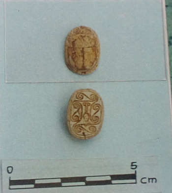
At el-Kawa, on the eastern bank, two scarab beetles were found unfortunately out of context. The first was found beside the grave of a child and is inscribed with a hieroglyphic phrase; it is interpreted by Eisa (Reference Eisa1999) as being an amulet dedicated to the god Amun. A second was found by a local citizen and has the Egyptian Hieroglyphic signet (nfr), which means beautiful (Eisa Reference Eisa1999). Previously, only one scarab had been known, from Arkell's work at Kosti, included in a grave of unknown (Napatan or Meroitic?) date (Figure 2).
Small scarab with nfr sign. From Eisa (Reference Eisa1999).

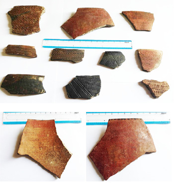
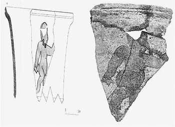
Both hand-made and wheel-made pottery was found in many sites, along with foundation remains at el-Dirwa (Eisa Reference Eisa2004), about 40 km south of Khartoum (Figure 1). The former (Figure 3) is found on the majority of sites and is characterized by décor without parallel to the north (Eisa Reference Eisa1999, Reference Eisa2002, Reference Eisa2004). Familiar Meroitic décor is on the latter (Figures 3 and 4) and is inclusive of animal, human, and plant depictions, which Eisa (Reference Eisa2004) drew parallels with similar from Musawwarat el-Sufra and el-Hamadab.
Sherds from el-Beja el-Diwaihaia. From Abdalla (Reference Abdalla2015).

(a) Complete Meroitic vessel. From Eisa (Reference Eisa1997). (b) Sherd from el Dirwa with human decoration. From Eisa (Reference Eisa2004).

At Goz Nori, Wad el-Magzoub and Wad jar el-Nabi are burials dating to the Meroitic; these burials have accompanying grave goods which include iron arrowheads, beads, iron knives, iron spears, and iron archer equipment (Eisa Reference Eisa and Zach2015). The majority of the iron weapons were in a bad state of preservation. The source of the iron ore was probably from the north as there are no local deposits. Bashir (Reference Bashir2007) has speculated that the spears have similarities with spears from the Late Meroitic, with a single barb and a tang, and another type identified as a small spear or larger arrowhead. Both of these types are also known from other sites along the Blue Nile (Crawford and Addison Reference Crawford and Addison1951, 129; el-Tayeb Reference El-Tayeb1999).
Bolstering the finds from Eisa's work have been further finds from local villagers. At Gareda, about 3 km south of el-Getaina, gold objects were found: an amulet for the Egyptian god Ptah as well as the goddess Bes standing on two crocodiles. There is also a small amulet of a bird, a ram's head, and part of an incomplete necklace (Leclant and Clerc Reference Leclant and Clerc1986). Near el-Kawa, a scorpion was found identical to one at el-Getaina. Beads, part of an incomplete cartouche with a sun-disk, and bracelets were also located and handed over by locals at el-Kawa (Geus Reference Geus1984).
The second project is the Italian Archaeological Mission working in central Sudan, south of Omdurman. A total of five Al Khiday sites were found and excavated (Usai et al. Reference Usai, Salvatori, Jakob and David2014). Of these, Al Khiday-1 (16-D-5) and Al Khiday-3 (16-D-3) were reused in the Meroitic and post-Meroitic as settlements, while Al Khiday-2 (16-D-4) has a Meroitic burial cemetery phase. The published total of excavated Meroitic graves from 16-D-4 currently stands at 43 and are described by Usai et al. (Reference Usai, Salvatori, Jakob and David2014). They are radio metrically dated to between the first century BC and the second century AD, contemporary with Jebel Moya. They suffered disturbance by robbers in antiquity.
The construction of the graves at 16-D-4 shows Meroitic influence with a bedrock-incised chamber off the circular- or ellipsoidal-shaped pits accessed by a shaft (Usai et al. Reference Usai, Salvatori, Jakob and David2014, 187). Like Meroitic burials at El Geili to the north of Khartoum, there is a west–east orientation of the burial chamber and the grave, while the individual is contracted and positioned facing north with the head to the west, and finally a stone pillow is sometimes present (Usai et al. Reference Usai, Salvatori, Jakob and David2014, 193). The contrast with Jebel Moya, with its shallow sandy burials that have no stone linings or permanent superstructures, has been taken to mean the funerary practices at Site 16-D-4 were influenced by their counterparts in the Shendi Reach.
Dental caries rates were low, indicating that the 16-D-4 individuals did not have a lot of carbohydrates in their diet, while the high calculus rate is believed to be the result of meat protein consumption (Usai et al. Reference Usai, Salvatori, Jakob and David2014). However, 11% of the permanent teeth exhibited enamel hypoplasia, which is indicative of malnutrition or other dietary stress. Some of the accompanying grave goods, including two feeding cups and other pottery vessels, resemble those found within the Meroitic heartland. The economy of the people is regarded by the Mission as being predominantly pastoral (Usai et al. Reference Usai, Salvatori, Jakob and David2014). These results in totality have been taken to mean that this area was within Meroe's sphere of political control (Usai et al. Reference Usai, Salvatori, Jakob and David2014, 195), which was previously postulated by Eisa (Reference Eisa1999).
Eisa's work, though, did not uncover any large Meroitic settlements or cemeteries datable to the Meroitic timeframe, which may indicate that the Meroitic political control did not extend much further south from Al Khiday. Instead, it appears that what is found to the south was the result of trade, traders, and possibly trading stations. It is hoped that new long-term systematic surveys will be established south of Al Khiday geared towards finding new large Neolithic and Meroitic-era localities to excavate, as the Rabak's archaeology has been destroyed and Kosti's is severely endangered. There are many questions to be answered which would tie into the work not only of the Italian Mission but also the University College London–University of Khartoum–NCAM's mission at Jebel Moya to more comprehensively elucidate the unknown prehistory of this important region at the juncture between the Sahel to the west and the Ethiopian borderlands to the south-east.
Discussion
The current state of research in the White Nile region, which is a crucial juncture between the Meroitic heartland, the Sahel belt to the west, and the Gezira and Butana plains to east, remains in its infancy. The current paucity of data outside of excavations at Al Khiday means that it cannot yet be said with any degree of certainty if the Meroitic-derived materials and building features is due to the limited number of surveys or because the region south of Al Khiday was regarded as unimportant. On the opposing Blue Nile, limited excavations of graves occurred in 1921 and 1925 around Old Sennar, which was postulated by Addison (Reference Addison1950) to have been a Meroitic trading station. Ultimately though, the White Nile region has received very little attention since the early excavations there (Edwards Reference Edwards1989, 43). Recently in 2017, excavations have started anew at Jebel Moya halfway between the two Niles in the southern Gezira Plain (Brass et al. Reference Brass, Adam, Fuller, Stevens, Hassan, Kozieradzka-Ogunmakin, Abdallah, Alawad, Abdalla, Wellings and Abdelrahman2018).
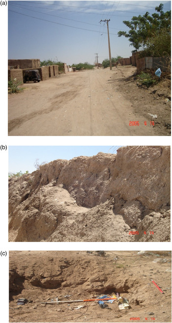
Given the relative regional paucity of the data, careful evaluation of what is available is especially important. The very disturbed nature of several sites close to the Nile, for example el-Dirwa and el-Getaina, suggests that a high level of site destruction may be expected (Edwards Reference Edwards1989, 131), which has impeded both the survival and the recognition of occupational remains relating to this time period.
The majority of the extant data derives from a series of surveys and small-scale rescue excavations carried out by the team of the White Nile Project between 1997 and 2010 (Figure 5). At last count, there were at least five archaeological sites (Dirwa, Wad Jar el-Nabi, Goz Nori, Wad el-Magzoub, el-Kawa) which have some surviving Meroitic features and remains. I was, however, only able to re-survey three (Dirwa, Wad Jar el-Nabi, Goz Nori) in late 2014, as Wad el-Magzoub and el-Kawa have now been erased. What I observed correlates with Eisa's reports. It is unfortunate that the rescue excavations could not have been more extensive or that the reports are not more detailed.
(a) and (b) el-Beja site affected by Nile floods and modern construction work. From Abdalla (Reference Abdalla2015). (c) el-Dirwa, affected by trees and military installations. From Abdalla (Reference Abdalla2015).

To date, no firing kilns have been found and no equipment necessary to make wheel-turned pottery. The confinement of wheel-made pottery to the northern White Nile (e.g. el-Dirwa and el-Getaina amongst others) indicates exchange activities occurring between this area and the major Meroitic centres, while the work at Al Khiday suggests that the sphere of Meroitic political influence extended down into the northern Gezira. The lack of wheel-made pottery on sites further south suggests that although trade likely occurred, these areas were politically independent. What is desperately need, however, is a programme of radiometric dating of pottery and associated contexts at targeted sites past Al Khiday up the White Nile.
Amulets and scarabs are widely spread but in fairly limited quantities. First appearing in ancient Egypt (Sparavigna Reference Sparavigna2009), there is a long list of the items excavated by Reisner from the south and north cemeteries at Meroe (Dunham Reference Dunham1963, 50–53). Amulets have also been found elsewhere within the Meroitic lands at locales such as Kerma (Bonnet and Tayeb Mahmoud Reference Bonnet and Tayeb Mahmoud1991) and el-Kadada (Geus and Lenoble Reference Geus and Lenoble1985). In the Gezira Plain, a few were found at Jebel Moya (Addison Reference Addison1949; Brass and Schwenniger Reference Brass and Schwenniger2013; Brass Reference Brass2016). Their presence outside of the political boundaries of the Meroitic state all the way down to Kosti (and maybe beyond?) speaks to an as yet unidentified culturally embedded significance in these items, whether from trade or heirlooms.
Also present are items made out of iron. The production of iron at Meroe has been pushed back to potentially before it became the capital of the new Meroitic state, the descendent of the prior Kushite kingdom called the Napatan state (Humphris et al. Reference Humphris, Alshishani, Scheibner and Bussert2018). Certainly, the evidence of iron objects found so far in Meroitic burial suggests that at first iron seems to have been confined to small objects of adornments, or personal items for the highest ranks of society (Humphries and Rehren Reference Humphries, Rehren, Lohwasser and Wolf2014, 178). Gradually, however, iron became more common, perhaps as the number of artisans with the knowledge of how to produce iron grew, or more exotic items entered the economies of the upper echelons of society (Humphries and Rehren Reference Humphries, Rehren, Lohwasser and Wolf2014). Lenoble (Reference Lenoble2006) postulated that the presence of iron weapons in Meroitic burials was a symbolic representation of political and religious dominance and power. Iron symbolism has also been linked by Haaland and Haaland (Reference Haaland and Haaland2007, 375) to three spheres of Meroitic society: royal, production, and the gods, in particular Apedemak (god of warfare and creation). Iron arrowheads in the area of study were found in association with skeletons, pottery, beads, and other remains and were in a bad state of preservation; their wooden shafts had long since decomposed, but iron ore itself may have held significance.
Precisely how these items originating from the Meroitic state were ideologically and culturally integrated into the belief systems of the local pastoral, fisher, and agro-pastoral people beyond the direct control of the Meroitic state is as yet unknown. All of the sites are within 1–2 km from the banks of the White Nile, with the exception of Wad el-Magzoub at around 25 km distant from the east bank. These placements may not just be an artefact of where the surveys were conducted but likely also reflect an underlying reality: the use of the Blue Nile as a transport mechanism for Meroitic goods and traders, and the spread of Meroitic influence, north to south, as shown by the presence of Meroitic objects on more than one site. Future systematic surveys, including underwater archaeology, may provide clarification. The area has untapped potential to examine these and other issues from the perspective of local people interacting with a powerful northern neighbour who, it must not be forgotten, could well have conducted military raids south for slaves, retribution, and to extract other natural resources needed for its industries in the Shendi Reach.
Acknowledgements
First, I would like to thank Professor Khider Adam Eisa, Faculty of Education, University of Khartoum, whose survey and brief excavations projects along the eastern bank of the White Nile provided so much valuable information. I also thank Dr Michael Brass for his comments on drafts and assistance with language, and the reviewers for their invaluable suggestions.