Rapid climate change often compels societies to adapt socioeconomic systems to changing conditions or to mitigate its impact (Solomon et al. Reference Solomon, Qin, Manning, Chen, Marquis, Averyt, Tignor and Miller2007). For many small-scale agriculturalists, the only means of adaptation to drought is migration. Seeking, quite literally, greener pastures in hard times reflects a tactic that people have used frequently throughout history and prehistory (e.g., D'Andrea et al. Reference D'Andrea, Huanga, Fritz and Anderson2011; Kohler and Varien Reference Kohler and Varien2012; Kohler et al. Reference Kohler, Varien and Wright2013; Newland Reference Newland2011), and migration can have transformative effects on both migrants and local populations. Some of the most critical issues in the contemporary world are linked to shifting environmental conditions and, in particular, extensive drought (Gleick Reference Gleick2014; Kelley et al. Reference Kelley, Mohtadi, Cane, Seager and Kushnir2015).
These types of socioenvironmental events are not new to humanity. In fact, some argue that such events helped shape the history of our species (e.g., Behrensmeyer Reference Behrensmeyer2006; Calvin Reference Calvin2002), and human responses to climate change have long been an important consideration in archaeological inquiry (e.g., Childe Reference Childe1934; Fagan Reference Fagan2000, Reference Fagan2008; Kennett et al. Reference Kennett, Breitenbach, Aquino, Asmerom, Awe, Baldini, Bartlein, Culleton, Ebert, Jazwa, Macri, Marwan, Polyak, Prufer, Ridley, Sodemann, Winterhalder and Gerald2012; Richerson et al. Reference Richerson, Boyd and Bettinger2001). This paper focuses on the Fort Ancient culture in the Middle Ohio Valley as a case study for understanding the relationship between rapid climate change and the movement of people. In doing so, it contributes to the idea that the movement of people played a large role in the process of Mississippianization in the Ohio Valley.
Fort Ancient is a term loosely applied to communities of maize farmers throughout the Middle Ohio Valley between approximately AD 1000 and AD 1650 (Cook Reference Cook2008, Reference Cook2017; Drooker Reference Drooker1997; Griffin Reference Griffin1943; Henderson Reference Henderson1992; Pollack et al. Reference Pollack, Henderson and Begley2002). Most Fort Ancient sites lie along the primary tributaries of the Ohio River, including the Great and Little Miami Rivers in southeast Indiana and southwest Ohio, the Scioto River in central Ohio, the Licking River in Kentucky, and the Hocking and Muskingum Rivers of southeast Ohio (Figure 1). We focus on well-dated early Fort Ancient villages in the Great and Little Miami River valleys of southwest Ohio and southeast Indiana, where archaeologists have long recognized Mississippian influences (Cook Reference Cook2008, Reference Cook2017; Cowan Reference Cowan1987; Griffin Reference Griffin1943). We use data derived from the Living Blended Drought Atlas (LBDA; Cook et al. Reference Cook, Seager, Heim, Vose, Herweijer and Woodhouse2010), a proxy for moisture availability, to explore push and pull factors (sensu Anthony Reference Anthony1990) that influenced the movement of agricultural communities from Mississippian centers to peripheral river valleys. After examining paleoclimate data in conjunction with new archaeological data from early Fort Ancient communities, we posit that the movement of displaced Mississippians into this region fostered the emergence of the novel constellation of characteristics that archaeologists refer to as Fort Ancient culture.
Cultural regions, study area, and specific sites discussed in text.

Climate Change and Migration
The history of how archaeologists have studied migration traces the ebb and flow of Americanist archaeology. In early culture historical approaches, migration and diffusion were the primary mechanisms of cultural change (Rouse Reference Rouse and Thompson1958, Reference Rouse1986; Thompson Reference Thompson1958). With the shift toward a more scientific epistemology, processual archaeologists focused on local and internal factors and considered outside influences relatively superfluous and unimportant (Trigger Reference Trigger2006). This prompted Anthony (Reference Anthony1990) to warn archaeologists that, while not all change comes from external sources, migration was likely as important a causal agent in prehistoric societies as it is among contemporary populations. As such, we should not dismiss migration wholesale but instead include it as a working hypothesis when it makes sense to do so. Today, archaeologists realize that movement among social groups was common in prehistory and should be considered in explaining culture change (e.g., Cameron Reference Cameron2013).
Culture historians established criteria for identifying and tracing migration in the archaeological record. Standing out among them is Rouse (Reference Rouse and Thompson1958, Reference Rouse1986, Reference Rouse1993), whose criteria are as follows:
1) identify the migrating people as an intrusive unit in the region it has penetrated; 2) trace this unit back to its homeland; 3) determine that all occurrences of the unit are contemporaneous; 4) establish the existence of favorable conditions for migration; 5) demonstrate that some other hypothesis, such as independent invention or diffusion of traits, does not better fit the facts of the situation. [1958:64]
These criteria provide a framework for identifying migration in local and regional archaeological sequences.
A common element to examinations of population movement is to identify push factors (stressors) at the source of moving groups and pull factors (advantageous conditions) at the presumed destination (Anthony Reference Anthony1990). Anthony (Reference Anthony1990:899) suggests that “migration is most likely to occur when there are negative (push) stresses in the home region and positive (pull) attractions in the destination region, and the transportation costs between the two are acceptable.” In the present study, paleoclimate data allow us to explore some potential push and pull factors, which, when combined with archaeological data, help to clarify regional dynamics.
The influence of climate change on migration is obvious in contemporary situations such as the migrant crises in the Near East, where long-term, severe droughts resulted in the mass movement of rural farmers into urban centers (Kelley et al. Reference Kelley, Mohtadi, Cane, Seager and Kushnir2015). Likewise, low rainfall appears to drive migration from rural to urban areas in sub-Saharan Africa (Barrios et al. Reference Barrios, Bertinelli and Strobl2006). In these cases, both push (drought) and pull (urban infrastructure and promise of resources) factors help explain why people moved and their preferred destination. Similar trends are evident in prehistoric sequences where climate proxies are available (e.g., Benson et al. Reference Benson, Pauketat and Cook2009; Kennett et al. Reference Kennett, Breitenbach, Aquino, Asmerom, Awe, Baldini, Bartlein, Culleton, Ebert, Jazwa, Macri, Marwan, Polyak, Prufer, Ridley, Sodemann, Winterhalder and Gerald2012). An example is the movement of people throughout the American Southwest in response to droughts of the Medieval Climate Anomaly and cooler temperatures associated with the onset of the Little Ice Age. Benson and Berry (Reference Benson and Berry2009) highlight cultural responses to the onset of droughts in the Four Corners region during the twelfth and thirteenth centuries. In this case, a wet period from AD 1045–1130 saw building activity and aggregation throughout the region. A subsequent series of droughts resulted in widespread instability and movement. Many areas saw decreased building, settlement reorganization, and often emigration. During this period, the development of migrant communities is evident in surrounding regions (Benson and Berry Reference Benson and Berry2009:105–106). In this case, drought was a significant push factor, forcing both cultural reorganization and emigration. Conditions in regions where drought was not as significant a factor provide potential pull factors. Seeking greener pastures is a viable strategy in times of drought (Black et al. Reference Black, Bennett, Thomas and Beddington2011).
Archaeologists have not ignored links between climate and cultural change in the Midcontinent. Griffin (Reference Griffin1961) highlighted the importance of fluctuating climate systems in this region, suggesting that warmer periods fostered cultural fluorescence, including the spread of maize farming and village life about AD 700–1200, while the subsequent Little Ice Age resulted in periods of cultural decline. Baerreis and colleagues (Reference Baerreis, Bryson and Kutzbach1976) used more detailed paleoclimate proxies in the western Great Lakes region to assess the validity of Griffin's (Reference Griffin1961) work, supporting his idea of a transition from warm to cool conditions around AD 1200. Inferences of migration in Griffin's (Reference Griffin1961) work stem more from cultural historical assumptions than archaeological evidence, although at times he does note connections between western Fort Ancient and Mississippian groups (Griffin Reference Griffin1943). Nolan and Cook (Reference Nolan and Cook2010a) used the North American Drought Atlas, an early moisture proxy (Cook et al. Reference Cook, Woodhouse, Eakin, Meko and Stahle2004), to examine spatial patterning in moisture availability in the Middle Ohio Valley. Relying on the Winterhalder-Kelly model of sharing, they used variation in moisture to predict social responses such as cultural interaction. Ultimately, they found that commonly held models of development fit well with behaviors predicted from an optimal foraging model. They also suggested that moisture stress helps explain the development of social complexity at Cahokia (Nolan and Cook Reference Nolan and Cook2010b). However, lacking in the Middle Ohio Valley and many parts of the Eastern Woodlands are detailed and well-dated examinations of cultural responses to changing climate systems.
The Palmer Drought Severity Index and Climate Change
The methods for reconstructing past climates have progressed over past decades and include ice core analysis (e.g., Thompson Reference Thompson2000), speleothems (e.g., Kennett et al. Reference Kennett, Breitenbach, Aquino, Asmerom, Awe, Baldini, Bartlein, Culleton, Ebert, Jazwa, Macri, Marwan, Polyak, Prufer, Ridley, Sodemann, Winterhalder and Gerald2012), lake sediment cores (e.g., Benson et al. Reference Benson, Smoot, Lund, Mensing, Foit and Rye2013; Hodell et al. Reference Hodell, Brenner, Curtis and Guilderson2001), and isotopic analysis of faunal remains (e.g., Wurster and Patterson Reference Wurster and Patterson2001). Each technique has strengths and weaknesses and is situationally dependent. Paleoclimate proxies derived from tree-ring data, the focus of the present study, provide excellent temporal resolution, but are limited by the lifespan of trees and the availability of prehistoric wood. One way that paleoclimatologists have applied tree-ring data to understanding paleoclimates is through the Palmer Drought Severity Index (PDSI), which provides a modeled measure of soil moisture that acts as a proxy for general levels of drought and moisture abundance. Following Palmer's (Reference Palmer1965) designations, this index ranges from severe drought (−4.0) to near normal conditions (−0.5–0.5) to extremely wet (4.0). Over the past two decades, Cook and others (Cook et al. Reference Cook, Woodhouse, Eakin, Meko and Stahle2004; Cook et al. Reference Cook, Seager, Heim, Vose, Herweijer and Woodhouse2010) have developed continental datasets incorporating PDSI data. In North America, two generations of tree-ring-based paleoclimate reconstructions are available. The North American Drought Atlas (NADA) uses reconstructed PDSI data to interpolate a continental climate model in a 2.5-×-52.5 degree grid consisting of 286 points based on 835 tree-ring chronologies (Cook et al. Reference Cook, Woodhouse, Eakin, Meko and Stahle2004). The Living Blended Drought Atlas (LBDA) uses an updated database of tree-ring data to create a higher resolution continental map at a 0.5-×-0.5 degree resolution of 11,396 grid points based on 1,845 tree-ring chronologies (Cook et al. Reference Cook, Seager, Heim, Vose, Herweijer and Woodhouse2010). Temporal spans for reconstructed data vary by region, but these proxies provide an informative glimpse into past moisture regimes at local, regional, and continental levels. The present study relies on LBDA data from the Midcontinent, a region in which data are available for the past millennium.
One of the best ways to consider climate is in terms of parameters and thresholds. The environment sets general parameters within which humans act. Changes in these parameters, particularly abrupt and intense changes, likely lead to shifts in human behavior (e.g., Fagan Reference Fagan2000, Reference Fagan2008). Climate thresholds represent times when systemic change occurs to a point where the climate system cannot easily return to its previous state (Alley et al. Reference Alley, Marotzke, Nordhaus, Overpeck, Peteet, Pielke, Pierrehumbert, Rhines, Stocker, Talley and Wallace2003). Abrupt climate changes, which are particularly potent, are those that take “place so rapidly and unexpectedly that human or natural systems have difficulty adapting to it . . . [they are] likely to be significant, from a human perspective, if they persist over years or longer, are larger than typical climate variability, and affect sub-continental or larger regions” (Alley et al. Reference Alley, Marotzke, Nordhaus, Overpeck, Peteet, Pielke, Pierrehumbert, Rhines, Stocker, Talley and Wallace2003:14). Such abrupt changes can affect the social structures within which humans participated by altering ecological and economic aspects of society. Altering access to resources, and how plants and animals behave, influences shifts in subsistence patterns, which can have contingent effects on society. In essence, abrupt changes in climate systems that cross thresholds can act as punctuated events, altering human behavior and cultural systems. As the contemporary cases noted above suggest, droughts can reach thresholds that force human societies to change; in these situations, migration is the most advantageous response.
The Rise and Fall of Cahokia
Recent research into the relationship between climate change and the rise and fall of the Mississippian polity at Cahokia has revealed intriguing patterns. Benson and colleagues (Reference Benson, Pauketat and Cook2009) have explored the influence of shifting climate conditions on the people of Cahokia and have identified three primary elements: (1) Cahokia developed around AD 1050 in the context of above-average rainfall; (2) Cahokia began to decline with the onset of multidecadal droughts around AD 1100–1150; and (3) as a result of droughts, populations abandoned Cahokia's surrounding tributary farming communities and dispersed by AD 1200.
During the Terminal Late Woodland period (ca. AD 900–1050), Cahokia was likely one of many comparable villages in the American Bottom that grew local Eastern Agricultural Complex crops and maize (Lopinot Reference Lopinot, Pauketat and Emerson1997). At approximately AD 1050, events unfolded that fostered the rapid development of Cahokia as the foremost polity in the region, with large-scale construction following a predetermined site layout, a novel form of household architecture, and marked social inequality (Pauketat Reference Pauketat1994). Benson and colleagues (Reference Benson, Pauketat and Cook2009) noted the relationship between these Lohmann phase (ca. AD 1050–1100) developments and a notably wet period in American Bottom history. Although they note that this period may have decreased productivity in some parts of the American Bottom as a result of flooding, wetter conditions likely increased productivity in local upland settings and probably also led to the beginnings of farming communities like the Richland Complex (Alt Reference Alt2002, Reference Alt, Butler and Welch2006; Pauketat Reference Pauketat2003). Such conditions also likely would have resulted in increased crop yields throughout most of the American Bottom.
Subsequent developments at Cahokia during the Stirling phase (ca. AD 1100–1200) point to changes in the sociopolitical makeup of this settlement. Throughout the early Stirling phase, the mound building and development of political/ritual administrative systems begun in the Lohmann phase were continued. At approximately AD 1150, these practices appear to have waned sharply, and the construction of the first of numerous palisades began. Benson and colleagues (Reference Benson, Pauketat and Cook2009) note the strong association between the shift in practices at Cahokia and the onset of numerous multidecadal droughts starting around the mid-twelfth century and lasting through the mid-thirteenth century. Nolan and Cook (Reference Nolan and Cook2010b) also suggest that droughts during this period fostered the development of complexity in the American Bottom.
These droughts may also have affected the upland farming communities tethered to the Cahokia Polity. These Richland Complex farming communities, which appear to have participated in the Mississippian system and to have supplied surplus maize to Cahokia (Pauketat Reference Pauketat2003), were abandoned by AD 1200 (Benson et al. Reference Benson, Pauketat and Cook2009:472). Benson and colleagues (Reference Benson, Pauketat and Cook2009:478) suggest that “even if Cahokians attempted to maintain the social and political status quo, they would have done so in the face of people leaving Cahokia and, quite likely, the region surrounding Cahokia.” This disaggregation of people around Cahokia likely further influenced the decline of Cahokia and created numerous migrant communities.
Climate Change along the Fort Ancient Mississippian Periphery
The work of Benson and colleagues (Reference Benson, Pauketat and Cook2009) provides a compelling glimpse into the relationship between climate change and the rise and fall of Cahokia. It also creates a scenario in which people and communities dispersed from the American Bottom potentially because of drought and associated economic instability. The question this raises is what were the environmental characteristics on the peripheries of the Mississippian system and how does this relate to emigration from the Central Mississippi Valley? In other words, where did these people go and why? Answering this question points to whether push and/or pull factors influenced the movement of people out of Mississippian centers in the Midcontinent.
To address this question, we use the LBDA dataset (Cook et al. Reference Cook, Seager, Heim, Vose, Herweijer and Woodhouse2010) to reconstruct paleoclimate in the Ohio Valley between AD 1050 and 1300. The study area consists of a region between 35°N and 45°N latitude and 80°W to 100°W longitude; this permits examination of both the Central Mississippi Valley and the Lower and Middle portions of the Ohio Valley (Figure 1). We analyze and map LBDA data in time slices that reflect 25-year averages of modeled soil moisture availability for each data point. We then interpolate point data for each period using the Spatial Analyst extension in ArcGIS v.10.2 to allow examination of spatial patterning across the study area.
AD 1050–1099
During the AD 1050–1074 period, most of the study region experienced relatively wet conditions after approximately 50 years of minor droughts (Figure 2a). PDSI values range between −2.24 (moderate drought) and 1.37 (slightly wet). However, most of the study area ranges between −0.30 (comparable to normal) and 1.37 (slightly wet). Considered spatially, this is one of the most consistently wet periods examined. The Middle Ohio Valley, particularly between the Falls of the Ohio (near the Prather site) and southwest Ohio, experienced wetter than normal conditions. Emerging Mississippian polities like Cahokia, Wickliffe, Kincaid, and Angel experienced conditions comparable to modern moisture levels.
PDSI values in the study region between AD 1050 and 1174 by 25-year time slice: (a) AD 1050–1074; (b) AD 1075–1099; (c) AD 1100–1124; (d) AD 1125–1149; (e) AD 1150–1174.

In the AD 1075–1099 period, drought affected the northern and western portions of the study region, while relatively wet conditions continued in the Middle Mississippi Valley and the Lower Ohio Valley (Figure 2b). PDSI values range from −2.40 (moderate drought) to 1.21 (slightly wet). Although much of the northern Great Plains witnessed drought, the central part of the continent was comparatively wet. Particularly, the area near the confluence of the Ohio and Mississippi Rivers, including the centers of Wickliffe and Kincaid, experienced wetter than normal conditions. The area around Cahokia experienced wet conditions as well. The lower Ohio Valley experienced similarly wet conditions, including the centers at Angel and Prather. During this time, conditions in the Middle Ohio Valley were comparable to modern moisture levels. This period is coeval with the Lohmann phase of the American Bottom, which saw marked social reorganization and the construction of large-scale public works.
AD 1100–1149
During the AD 1100–1124 period, most of the study region experienced drought conditions (Figure 2c). PDSI values range between −1.25 (mild drought) and 1.59 (slightly wet); the ubiquity of drought and locations of particularly dry conditions are notable. Much of the Great Plains experienced drought at this time, as did portions of the Central Mississippi Valley. In particular, the Mississippian center at Cahokia experienced some of the driest conditions during this time. Wickliffe, Kincaid, and Angel also experienced droughts, but to lesser degrees. Notably, the Middle Ohio Valley is the only area in the study region to experience conditions at or wetter than modern averages. As one moved up the Ohio River, conditions gradually became wetter. The theme of dry conditions in the Central Mississippi and the Lower Ohio Valleys and relatively wet conditions in the Middle Ohio Valley continues throughout the next century.
The drought extends into the AD 1125–1149 period (Figure 2d). PDSI values range from −3.12 (severe drought) to 0.39 (incipient wet spell); this range is considerably larger and more skewed toward negative values than any prior period. However, the most intense droughts occurred in the northern portion of the study region (modern day Michigan) and may relate to Great Lakes microclimates. Many populations throughout the Great Plains and Eastern Woodlands continued to experience moderate droughts. Mississippian centers at Cahokia, Wickliffe, Kincaid, and Angel experienced droughts that extended from the previous period and became more severe. Many of these centers would have experienced approximately 50 years of primarily drought conditions, on average, at this point. The only portion of the study area that continued to experience conditions at or above modern values was the Middle Ohio Valley.
AD 1150–1199
During the AD 1150–1174 period, droughts continued across most of the study region (Figure 2e). PDSI values range from −3.07 (severe drought) to 1.05 (slightly wet). The driest conditions appeared in the northwest portion of the study area, in modern-day Nebraska and South Dakota. The only wet conditions were around Lake Erie and in the deep southwest of the study region. Most of the Lower Ohio Valley experienced drought, while the Middle Ohio Valley continued to experience average conditions. Mississippian centers at Cahokia, Wickliffe, Kincaid, and Angel continued to experience dry conditions. Although, on average, these droughts were not severe, they were consistent and at this point had produced about 75 years of relatively dry conditions.
In the AD 1175–1199 period, the majority of the region continued to experience drought conditions (Figure 3a). PDSI values range between −3.38 (severe drought) and 1.08 (slightly wet), which is consistent with the previous 25 years. The only areas that did not experience droughts during this period were the Middle and Upper Ohio Valleys, extending from just east of the Falls of the Ohio (near the Prather site) through Ohio, West Virginia, and Pennsylvania. To note, Cahokia, Wickliffe, and Kincaid continued to experience moderate to severe droughts, extending on-average drought conditions here and at adjacent locales to approximately 100 years.
PDSI values in the study region between AD 1175 and 1299 by 25-year time slice: (a) AD 1175–1199; (b) AD 1200–1224; (c) 1225–1249; (d) AD 1250–1274; (e) 1275–1299.

AD 1200–1249
During the AD 1200–1224 period, drought conditions continued for much of the region, although the severity lessened (Figure 3b). PDSI values range from −1.51 (mild drought) to 1.62 (slightly wet). Most of the wettest values are in the study area's southwest and are largely inconsequential to the present study; most of this area still experienced slight droughts. The most notable areas of drought were the Central Mississippi Valley, the Lower Ohio Valley, and the Wabash River Valley, including Cahokia, Wickliffe, Kincaid, and Angel. The Middle Ohio Valley experienced, on average, incipient dry spells during this period.
During the AD 1225–1249 period, extensive droughts covered the northwest portion of the study region and moderate droughts affected much of the rest of the area (Figure 3c). PDSI values range between −4.48 (extreme drought) and 0.5 (wet spell). The central Mississippi Valley and the Lower Ohio Valley continued to experience drought, although of a less severe nature. Most of the Middle Ohio Valley remained comparatively wet in terms of moisture.
AD 1250–1299
The period of AD 1250–1274 reflects the end of drought conditions that lasted almost 150 years across much of the Midcontinent (Figure 3d). PDSI values range from between −0.91 to 1.09; this small range suggests that much of the region experienced relatively similar conditions during this period. Areas that experienced the wettest conditions tended to be the Middle Ohio Valley near the Falls of the Ohio, and the Lower Ohio Valley. The Central Mississippi Valley near Cahokia again experienced wet conditions not seen to this extent since the end of the eleventh century. The confluence of the Mississippi and Ohio Rivers experienced slight drought.
Between AD 1275 and AD 1299, much of the region was split between drought and relative wetness (Figure 3e). PDSI values range between −1.44 and 0.60; the droughts that returned in this period were less severe than those of previous centuries. The driest areas in the region during this period were in Michigan and northeast Ohio, and in the Central Mississippi Valley. Mississippian centers like Wickliffe and Kincaid experienced the most severe droughts; Cahokia and Angel experienced less severe droughts. Notably, many of their former inhabitants appear to have abandoned these centers by this point. The Middle Ohio Valley, along with parts of West Virginia and eastern Kentucky, experienced some of the wettest conditions in the study area during this period.
Mississippian Droughts and the Development of Fort Ancient Villages
Examining spatiotemporal patterning in moisture availability in the Midcontinent between AD 1000 and 1300 provides two notable trends (Figure 4). First, as noted by Benson et al. (Reference Benson, Pauketat and Cook2009), the period between AD 1050 and 1100 was notably wet throughout the Central Mississippi Valley and the Lower Ohio Valley, particularly between AD 1075 and 1100. This period encompasses the early rise of Cahokia and potentially the spread of a Mississippian way of life throughout some parts of the Midcontinent (e.g., Pauketat Reference Pauketat2007). Second, a marked period of drought throughout much of the study area began around AD 1100 and became more severe by AD 1200. This included not only Cahokia, but also much of the Central Mississippi and Lower Ohio Valleys, both identified by Cook and Price (Reference Cook and Price2015) as potential regions of origin for migrants found in the Fort Ancient region. Notably, these periods of mild to severe droughts persisted for about 150 years. During this period, changes in planned labor at Cahokia and emigration from this center and surrounding regions are evident. It was at this point that Fort Ancient settlements in the Middle Ohio Valley, many of which exhibit Mississippian characteristics, were founded. This region experienced less severe droughts and, in fact, often experienced conditions that were comparable to or wetter than contemporary conditions. The following overview explores new archaeological findings that highlight the unique nature of early Fort Ancient societies within the context of climate change and migration.
PDSI values for Cahokia, Angel, and State Line sites, AD 1000–1300 with 10-year running averages.

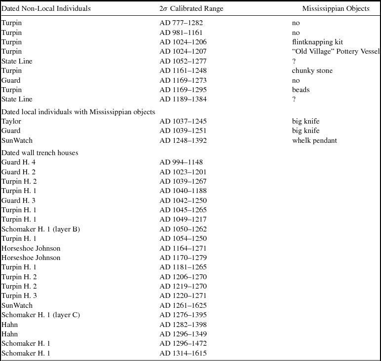
Mounting archaeological evidence supports the conclusion that at least in southwest Ohio and southeast Indiana, Mississippian migrants influenced early Fort Ancient settlements. Previously, some researchers suggest that Mississippian artifacts at Fort Ancient sites were late (i.e., post-AD 1400) trade items (e.g., Pollack and Henderson Reference Pollack, Henderson and Genheimer2000; Pollack et al. Reference Pollack, Henderson and Begley2002). But recent efforts have produced evidence of direct Mississippian contact (Comstock Reference Comstock2017; Cook et al. Reference Cook, Comstock, Martin and Burks2015) and biological connections (Cook Reference Cook2017; Cook and Price Reference Cook and Price2015; Cook and Schurr Reference Cook and Schurr2009). At the Turpin site (33Ha19), Ramey-like and Powell Plain–like vessels and negative painted jars and bowls are present (Griffin Reference Griffin1943) (Figure 5:h-j), as well as other Mississippian-style goods such as anthropomorphic (Figure 5:c-e) and large zoomorphic pipes (Figure 5:g). Many of these artifacts were recovered from contexts dating between AD 1000 and 1300 (Comstock Reference Comstock2017; Cook and Comstock 2014; Cook et al. Reference Cook, Comstock, Martin and Burks2015). At Guard (12D29), an adult male was buried with a large Ramey knife, and dates between AD 1039 and 1251 (Cook et al. Reference Cook, Comstock, Martin and Burks2015; Sedler Reference Sedler1990; Figure 5a).
Select Mississippian-style artifacts at early Fort Ancient sites.

Cook and Price (Reference Cook and Price2015) examine geochemical evidence for the movement of people into the Middle Ohio Valley. The strontium ratios (86Sr/87Sr) of human remains show that the highest proportion of non-local individuals came from the earliest sites in the region. In particular, Turpin contained the highest proportion (nearly one-third) of migrants, people born and raised outside the region. Potential regions of origin for these individuals include the Angel site in Indiana, the Middle Cumberland region of Tennessee, and Cahokia in Illinois. More recently, with the addition of strontium and biodistance studies, Cook (Reference Cook2017) added eastern Tennessee, where the Hiwassee Island site is located, as a possible source area for migrants to Turpin. These Mississippian areas of origin are in line with the archaeological evidence from Turpin. One important factor to note is that the non-local individuals in any site such as Turpin represent only the first generation of migrants; second-generation migrants would have strontium ratios that fall entirely within local ranges because they had spent their lives eating and drinking from local sources (Cook and Price Reference Cook and Price2015). This supports the conclusion that a large proportion of non-local individuals could have founded Turpin. Cook and Price's (Reference Cook and Price2015) study highlights the early and quite possibly formative nature of Mississippian migrants on the development of Fort Ancient culture and Turpin particular.
Based on multiple lines of evidence, Comstock (Reference Comstock2017) concluded that the case of Turpin (and likely Guard and State Line) meets all of Rouse's (Reference Rouse and Thompson1958) criteria for identifying migration in the archaeological record. First, early Fort Ancient communities in the lower Miami Valleys stand in stark contrast to the settlements of preceding Late Woodland foragers. While Late Woodland foragers were relatively mobile, subsisted primarily on local crops, and produced rock tempered cordmarked ceramics (Seeman and Dancey Reference Seeman, Dancey, Emerson, McElrath and Fortier2000), early Fort Ancient agriculturalists in southwest Ohio and southeast Indiana lived in large established villages, ate considerable amounts of maize (Cook and Schurr Reference Cook and Schurr2009), and produced finely made shell-tempered vessels with predominately plain surfaces. Second, the homelands for these migrants are readily identifiable. Mississippian people, goods, houses, and communities are now evident in this region associated with early dates. Third, these communities were contemporary and occupied at some point during the early Fort Ancient period (AD 1050–1250), a time that is consistent with developments in the American Bottom and other Mississippian locales. Finally, we have now shown that the droughts in the Mississippian heartland and much better conditions in the Middle Ohio would have provided “favorable conditions for migration” (Rouse Reference Rouse and Thompson1958:64). Taken together, these lines of evidence provide a strong case for migration as a catalyst for cultural change among early Fort Ancient communities.
Discussion
Following the work of Benson and colleagues (Reference Benson, Pauketat and Cook2009), we have explored the Mississippian system throughout the Central Mississippi Valley and the Ohio Valley in the context of climate change. By including the Lower and Middle Ohio Valley regions in addition to the American Bottom, we identified a potential explanation for a growing body of data that suggests that early Fort Ancient villages in the lower Miami Valleys had strong Mississippian connections (Cook and Price Reference Cook and Price2015; Cook et al. Reference Cook, Comstock, Martin and Burks2015). In particular, at a point in time when drought likely led to insecurity and increased social complexity at Cahokia, and catalyzed emigration from surrounding farming communities, we see the emergence of early Fort Ancient villages with distinctly Mississippian characteristics. By examining patterned variation in moisture availability over space and time, we identified potential push (drought at Mississippian centers) and pull (wet conditions in the Middle Ohio Valley) factors for migration.
The movement of Mississippian people as an explanation for change on the peripheries is not a new concept. Although movement had a central and sometimes myopic role in early Mississippian studies (Smith Reference Smith1984), recent efforts to identify and trace migration have been more nuanced. For example, Blitz and Lorenz (Reference Blitz and Lorenz2002) found that an influx of Mississippian migrants as early as AD 1040–1280 into the lower Chattahoochee River Valley catalyzed change among local Late Woodland populations. Based on the sudden appearance of Mississippian traits, including wall trench structures and shell-tempered ceramics, the authors argue for an intrusive Mississippian community. A similar example comes from Aztalan, which archaeologists have long considered an anomalous Mississippian frontier site (Goldstein and Richards Reference Goldstein, Richards, Emerson and Lewis1991). Through examination of skeletal remains, Price et al. (Reference Price, Burton and Stoltman2007) found that numerous individuals at Aztalan exhibit non-local strontium ratios and match well with the Central Mississippi Valley. Delaney-Rivera (Reference Delaney-Rivera2004) found evidence for the movement of Mississippian communities into portions of the Illinois Valley and suggests that these people moved into the region and catalyzed change within local Late Woodland populations.
Wall trench architecture provides another line of evidence for the spread of Mississippian people (Alt and Pauketat Reference Alt and Pauketat2011; Pauketat Reference Pauketat2007). This form of architecture is typically considered a Mississippian innovation that developed and spread from the American Bottom. Pauketat (Reference Pauketat2007:106) mapped the dispersion of this innovation, finding that it originated in Cahokia at approximately AD 1050, spread to a corridor roughly following the Central Mississippi Valley by AD 1100, and from there throughout the Southeast sometime after AD 1150 or 1200. A key element in the diffusion of wall trench architecture appears to have been the establishment of small enclave communities, as can be seen in the cases of Aztalan, Cool Branch, the Macon Plateau, and other small sites beyond the initial thrust of Mississippian expansion.
A notable exception to Pauketat's (Reference Pauketat2007) wall trench map is the Middle Ohio Valley and Fort Ancient communities, where archaeologists have been aware of the existence of wall trench architecture for some time (e.g., Cook Reference Cook2008; Cowan Reference Cowan1987; Cowan et al. Reference Cowan, Dunaba, Nass and Scott1990; Metz Reference Metz1885). However, with the exception of Cook's (Reference Cook2008) work at SunWatch, most of these cases are either archival field notes or were disseminated in small journals or museum publications. To Pauketat's map, we now add information regarding early wall trench communities in southeast Indiana and southwest Ohio (Figure 6; Table 1). Early in the Fort Ancient period (ca. AD 1000–1300), State Line, Guard, Turpin, Schomaker, and Horseshoe Johnson have all produced evidence of wall trench structures (Cook and Genheimer Reference Cook, Genheimer, Redmond and Genheimer2015). Directly dated early Fort Ancient wall trench structures were constructed at some point between AD 994 and 1280. A second round of wall trench structures is evident during the Middle Fort Ancient period (ca. AD 1300–1500). These structures at Schomaker, Hahn, and SunWatch date sometime between AD 1261 and 1625. Considering the prevalence of wall trench structures, it is clear that this form of architecture was more common than traditional set-post architecture at many Fort Ancient sites in the Middle Ohio Valley. The dates of wall trench structures, particularly during the early Fort Ancient period, are consistent with early Mississippian developments elsewhere in the Midcontinent. Sites like SunWatch (Cook Reference Cook2008) appear to represent a secondary spread of people up the Great Miami River Valley around AD 1200 or 1300.
Proposed spread of the wall trench house style in the Mississippian region (after Pauketat Reference Pauketat2007).

Radiocarbon Dates Associated with Non-Local Mississippian-style Houses and Burials.

How did these migrations unfold? Archaeologists have classified migration into multiple forms (Anthony Reference Anthony1990; Bellwood Reference Bellwood2005; Zvelebil Reference Zvelebil, Renfrew and Boyle2000, Reference Zvelebil2001). Of particular relevance here is leapfrog colonization (Zvelebil Reference Zvelebil, Renfrew and Boyle2000:2), which involves the “selective colonisation (sic) of an area by small groups, who target optimal areas for exploitation, thus forming an enclave settlement among native inhabitants.” This may address why many Mississippian settlements up the Ohio Valley, including Kincaid, Angel, State Line, Guard, and Turpin, all map onto large open floodplains with oxbow lakes and abundant aquatic resources. In essence, as they moved, these groups may have targeted what Smith (Reference Smith and Smith1978) referred to as the “Mississippian niche” (Comstock Reference Comstock2017; Cook Reference Cook2017).
Our work and that of Benson and colleagues (Reference Benson, Pauketat and Cook2009) provide additional lines of evidence to explain the trajectory of Cahokia and perhaps the rise and fall of other early to middle Mississippian polities like Kincaid, Wickliffe, and Angel. The rise of Cahokia was likely a rapid process involving a sequence of specific historic events underlain by gradual developments. A system of agriculture involving maize and local crops developed over a century or more in the American Bottom region. The efficacy of maize likely increased because of better moisture conditions during the Lohmann phase (ca. AD 1050–1100). It was during this time that rapid social transitions occurred; Pauketat (Reference Pauketat, Pauketat and Emerson1997:31) referred to this period as Cahokia's “Big Bang.” It is at this point that Cahokians cast aside traditional ways and introduced novel forms of architecture and living, including those reflected by the site's large central plaza, Monk's Mound, and the appearance of numerous wall trench communities in and around Cahokia. The events that spurred this transition may reflect the rise of a charismatic leader, the routinization of power, and the formation of novel religious organizations (Beck and Brown Reference Beck, Brown and Rowan2011; Pauketat and Emerson Reference Pauketat and Emerson1997). These events coincided with the noted period of wet conditions, which may have fostered the development of agricultural surpluses and the consolidation of power.
During the end of Cahokia's Stirling phase (ca. AD 1100–1200), a period that coincides with the onset of significant droughts, labor efforts culminated in the construction of most of the mounds and then shifted to the construction of large palisades. This period likely signals a sociopolitical shift toward the height of complexity with marked attempts to maintain chiefly power in times of stress; it may also mark the emergence of external threats. Benson and colleagues (Reference Benson, Pauketat and Cook2009) suggest that at this time also, people emigrated from the American Bottom and outlying farming communities like those of the Richland complex. These patterns, linked to drought and presumably economic instability, point to a struggle by elites to maintain influence over peripheral groups. Some members of these outlying communities had ancestors who migrated into the region during the Lohmann phase, like many of those in the Richland complex outside of Cahokia (Alt Reference Alt, Butler and Welch2006). These people thus had ties to other regions, ties they could have relied on as their social, religious, and economic links to Cahokia disintegrated.
Migrants searching for greener pastures and/or a reprieve from increasingly overbearing social inequality may have followed the Ohio River. Centers like Wickliffe, Kincaid, and Angel all demonstrate links to Cahokia and may have harbored displaced groups. Further up the Ohio River, sites like Prather (Munson and McCullough Reference Munson and McCullough2004) and State Line (Vickery et al. Reference Vickery, Sunderhaus, Genheimer and Genheimer2000) are Mississippian in many ways, but, as one avocational archaeologist described Prather, they tend to be “a diluted form of Mississippian” (quoted in Munson and McCullough Reference Munson and McCullough2004:16). These sites exhibit Mississippian characteristics such as wall trench architecture, large villages organized around plazas with large marker posts and mounds, and shell-tempered ceramics, but they lack many overt expressions of social hierarchy exhibited by other polities. In general, early Fort Ancient communities appear quite similar to small egalitarian Mississippian communities.
Why do many middle Ohio River Valley sites have strong links to the Mississippian polity at Cahokia? One possibility is that of religious proselytizing or the movement of religious colonists through the Midcontinent. Using the site of Trempealeau as a compelling example, Pauketat and colleagues (Reference Pauketat, Boszhardt and Benden2015) argue that religious specialists mapped onto a unique place on the landscape, essentially emplacing themselves and their religion within the local physical and social landscape. Archaeologically, this manifests itself as an early Mississippian settlement that is a relative outlier in the region. Pauketat and colleagues (Reference Pauketat, Boszhardt and Benden2015) consider Trempealeau as a site that “looks to have begun at or just before Cahokia's Big Bang” (Pauketat et al. Reference Pauketat, Boszhardt and Benden2015: 274) and where occupation “ended before AD 1100” (Pauketat et al. Reference Pauketat, Boszhardt and Benden2015:283). However, there is a question of timing. Many of the calibrated 2-sigma AMS ranges (Pauketat et al. Reference Pauketat, Boszhardt and Benden2015:Table 3) place the occupation of Trempealeau between AD 1050–1170. While this range does not confidently illustrate an occupation concurrent with the inception of Cahokia, it does fall in line with the expansion of Mississippian communities throughout the Midcontinent and Southeast during the Lohmann and Stirling phases of Cahokia (see Figure 6). This date range is also consistent with the appearance of Mississippian people, artifacts, and lifestyles in the Middle Ohio Valley, as discussed in the present study.
This potential scenario, involving environmental influences and peripheral migrant communities, raises two important questions. First, did small Mississippian groups move up the Ohio River prior to the droughts of the late twelfth and thirteenth centuries, or were the droughts the primary catalysts for movement? Comstock (Reference Comstock2017) suggested that multiple phases of wall trench construction at the Turpin site reflect an early (ca. AD 1020–1180) occupation followed by a later (ca. AD 1180–1250) one, the earlier fitting well with the sequence at Trempealeau noted above. Second, is the seemingly egalitarian nature of Fort Ancient communities a response to increasing control at Mississippian centers, or did hierarchy not develop in the Middle Ohio Valley because there were no severe droughts requiring the accumulation and redistribution of agricultural goods as is thought to be the case in Cahokia? These questions are fruitful avenues for research.
Conclusion
When Benson and colleagues (Reference Benson, Pauketat and Cook2009) noted key relationships between moisture availability and the cultural sequence at Cahokia, they initiated an investigation into the effects of the Medieval Climate Anomaly on the Late Prehistoric societies of the American Midcontinent. This project builds on their work by broadening the scale and shifting focus to a peripheral area of the Mississippian world. We have tied together aspects of climate, migration, and the development of complexity, and have ultimately identified important links between droughts in a Mississippian heartland and the emigration of people from that area. Summarizing recent archaeological work in the Middle Ohio Valley, we suggest that some of these Mississippian migrants made their way into this region, settling in egalitarian farming villages that archaeologists refer to as the Fort Ancient culture. Future work will help develop a richer understanding not only of the effects of the Medieval Climate Anomaly on Late Prehistoric societies, but also on the process of ethnogenesis among Fort Ancient societies after the initial movement of Mississippians into the region (Cook Reference Cook2017). In so doing, we can provide a more compelling and accurate understanding of the development and spread of a Mississippian lifestyle.
Acknowledgments
We would like to thank Ed Cook for directing us to the Living Blended Drought Atlas data. We would also like to thank John D. Richards and two anonymous reviewers for feedback that significantly increased the quality of this paper. We also appreciate Lane Fargher and Susan Pérez Medina for translating the abstract into Spanish.
Data Availability Statement
Archaeological data cited as part of this study are curated at the Cincinnati Museum of Natural History and the Peabody Museum, Harvard. Aggregated data on sites, artifacts, and dates are available by contacting the authors. For climate data, please see Cook and colleagues (Reference Cook, Seager, Heim, Vose, Herweijer and Woodhouse2010).