INTRODUCTION
The region of Pomerania on the south Baltic coast was one of the last areas of Slavdom to be Christianized. It was only after two missions undertaken by Bishop Otto of Bamberg in 1124–1125 and 1128 that an end was put to paganism and the permanent infrastructure of the church began to put down roots (Petersohn Reference Petersohn1979; Rosik Reference Rosik2010). Thanks to particularly detailed accounts provided in the missionary’s three biographies, created as early as in the mid-12th century, we know that during his two trips no fewer than 14 Christian sites were established on his initiative in 12 localities, consecrated by Bishop Otto himself. According to the biographies, all of these churches were built of wood (Kiersnowski Reference Kiersnowski1953; Rębkowski Reference Rębkowski2011).
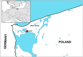
One of the places visited by the bishop, and in which a church was erected in 1124, was Liubin (or Lubin), referred to in the sources as a little town or stronghold (VP Reference Wikarjak and Liman1966; Herbord Reference Wikarjak and Liman1974). Scholars broadly agree that the account should be linked with the present-day village of Lubin (Figure 1), in the southwestern part of Wolin Island (e.g. Hofmeister Reference Hofmeister1924; Salis Reference Salis1924; Petersohn Reference Petersohn1979; Rosik Reference Rosik2010; Rębkowski Reference Rębkowski2011). The existence of a church there dedicated to St Nicholas is confirmed in a document issued by Duke Bogusław I of western Pomerania in 1186/1187 (PUB Reference Conrad1970).
Location of the Lubin stronghold.

ARCHAEOLOGICAL INVESTIGATION
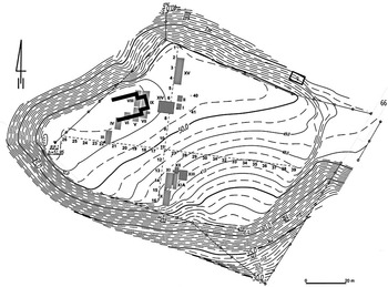
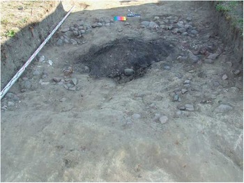
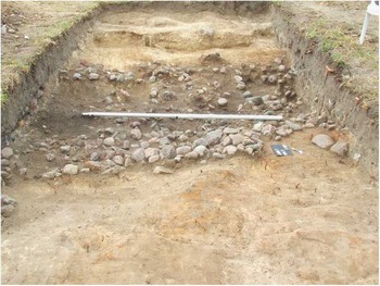
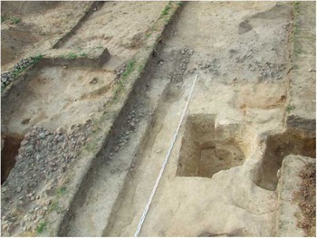
Between 2008 and 2011, archaeological excavations were carried out at the Lubin stronghold, searching for the relics of the medieval church, ranked among the oldest Christian churches in Pomerania, as one of the main objectives. The church was discovered as early as 2009, which was soon followed by the discovery of an associated inhumation cemetery (Figure 2). The main element of the structure identified in 2009 as the relics of the church was a fragment of a stone-and-clay foundation supporting the southern wall of a building oriented nearly perfectly along the W–E axis (Rębkowski Reference Rębkowski2016). The preserved ceiling of the foundation strip was uncovered only several centimeters beneath the present-day surface (Figure 3). It had been dug into compact moraine clay forming the natural bedrock, which occurs at a very shallow depth there, a fact which, along with stratigraphic observations made in adjacent trenches, suggests that this part of the stronghold must have been considerably levelled after the final demolition of the church in the modern period. The foundation strip was built from several layers of stones ranging from several up to about 40 cm in diameter, which were discovered along with yellow-brown clay in a trench 2.90–3.10 m wide (Figure 4). In the place where a cross-section was made, the preserved thickness of the foundation strip measured at least 60 cm, and was set in a foundation trench whose bottom part was filled with thin layers of charcoal-saturated deposits, sand, and clay. The width and direction of this trench corresponded precisely with those of the foundation strip.
Contour plan of the stronghold, with the explored trenches and the church’s relics marked black. Archaeological trenches are marked grey. Trenches marked hatched-grey are those where graves belonging to the church cemetery were found. Roman numerals indicate the designations of archaeological trenches, and arabic numbers along the cross-sections indicate the designations of research drillings.

Trench V: burnt pole from the construction of the southern wall of the church, set on a stone foundation strip.

Trench V: foundation strip after the exploration of the burnt pole relics.

At the ceiling of the stone foundation and at a distance of 2.5 m from each other, two regularly oval concentrations of charcoal were recorded, which were the remains of vertical posts set in the foundation in small hollows, playing the role of sockets of some kind. The posts must have constituted the basic structural element of the wall, with the space between them filled with wattle and daub. Such a solution is indicated by a layer of charcoal and burned-out clay discovered immediately between the stone foundation and the topsoil, which can be seen as a relic of the burned southern wall of the building. The clear imprints of the wattle survived in the clay originally covering the wattle. In addition, small lumps of lime were recorded in the upper part of the foundation, which in all likelihood should be interpreted as the remains of a whitewash covering the church’s walls from the inside.
In the eastern part, the foundation strip turns at a right angle to the north and forms what was originally a rectangular presbytery (Figure 5). The details of construction change slightly in this section, too. Only the bottom part of the foundation trench survived, the remaining part being obviously dismantled during the levelling of the area in the modern period, and it was not dug into any older feature. The preserved thickness amounted to only 20 cm. The foundation trench was filled with stones and slightly clayey sand. In the presbytery part, the foundation width ranged from 1.20 to 1.30 m.
Trenches V-IX: eastern part of the foundation strip (from the presbytery).

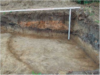
The extent of the investigated area has not allowed us to uncover the northern part of the presbytery and the foundation, which probably supported the church’s northern wall. Nevertheless, certain evidence relating to the northern wall was discovered in the explored trenches. Beneath the topsoil, in the northern part of the explored area, layers of clay strongly burned to an orange color were recorded, interspaced with a few-centimeter-thick layers of charcoal. The mentioned layers formed a band up to 2.5 m wide, stretching along the W–E axis, parallel with the foundation of the southern wall. The total thickness of these deposits reached several dozen centimeters. It was here also that lumps of burned-out clay were discovered bearing wattle imprints, along with stones in a loose arrangement. All of this allows us to conclude that we are dealing here with the relics of the church’s northern wall, built using a similar technique to the southern one and which had been damaged and collapsed during a huge fire (Figure 6).
Trench VIII: relics of the collapsed and burnt northern wall of the church (fired clay and charcoals), from where a series of different dates were obtained.

Next to the church and to the southeast of it, an associated inhumation cemetery was discovered. Thus far, 41 burials that survived fully or partly in anatomical order have been uncovered, along with the remains of several other burials. The necropolis displays all the features of burial rites typical of Christian church graveyards of that period. The deceased were placed uncremated into the grave, and the bodies were oriented parallel to the church’s axis (W–E) with the head to the west, according to the Christian custom observed during the Middle Ages (Müller-Wille Reference Müller-Wille1993; Rationale Reference Davril, Thibodeau and Guyot1995; Rębkowski Reference Rębkowski2011). In several places, more recent burials were dug into graves from the initial phase of the cemetery. Such a situation is typical of graveyards established by a church, i.e. in the central place of a settlement, where the area available for burial was limited. The deceased were placed in the grave in a supine position, with their hands stretched along the body, which is a very characteristic and emblematic element of the early medieval Christian burial rite in this part of Europe.
MATERIAL AND METHODS
The 14C analysis encompassed 36 samples of charred wood and organic matter collected during the excavations of the stronghold. The vast majority (24 samples) originate from the trenches situated outside the area where the church’s relics were recorded, whereas 12 samples were selected from the burned southern and northern walls of the church and from the charcoal-saturated deposit in the trench beneath the foundation of the southern wall.
Thirty-two samples were dated using the conventional liquid scintillation spectrometry (LSC) 14C dating technique at the Laboratory of Absolute Dating in Skała and Kraków, Poland (MKL signature). Organic samples were chemically pretreated with the acid-alkali-acid (AAA) method. After drying the sample, further procedures included a standard synthesis of benzene from carbonized samples (Skripkin and Kovalyukh Reference Skripkin and Kovalyukh1994, Reference Skripkin and Kovalyukh1998). Measurements were carried out with the Hidex 300 SL spectrometer (Krąpiec and Walanus Reference Krąpiec and Walanus2011).
Dating using the AMS technique was conducted in the Radiocarbon Laboratory in Poznań, Poland (Poz signature) (see Goslar et al. Reference Goslar, Czernik and Goslar2004 for details).
All dates were calibrated using the OxCal 4.2 calibration program (Bronk Ramsey and Lee Reference Bronk Ramsey and Lee2013) on the basis of the IntCal13 calibration curve (Reimer et al. Reference Reimer, Bard, Bayliss, Beck, Blackwell, Bronk Ramsey, Buck, Cheng, Edwards, Friedrich, Grootes, Guilderson, Haflidason, Hajdas, Hatte, Heaton, Hoffmann, Hogg, Hughen, Kaiser, Kromer, Manning, Niu, Reimer, Richards, Scott, Southon, Staff, Turney and van der Plicht2013). The chronology of the deposits within the stronghold was determined based on a model calculated using the OxCal procedures (the Sequence command). The beginning and end of the phase were determined using the Boundary Begin/Boundary end commands, and its duration was calculated using the Phase function.
RESULTS AND DISCUSSION
Timber fragments discovered within the charcoal concentrations recorded on the stone foundation provided no tree-ring sequence long enough to allow for dendrochronological analysis to be carried out and for the moment when the church was erected to be precisely determined. Therefore, the preliminary determination of the chronological position of the investigated building was based on portable sources (including coins), on the method known as historic dating, and on the entire cultural context of the site, which all suggested the church was built in the 12th century.
The collection of pottery discovered in the church is typical of Pomeranian assemblages from the transition between the early and late Middle Ages. It consists almost solely of fragments of traditional early medieval vessels, accompanied by only a few grey ware fragments. Thus, the demolition of the church can be placed at the close of the 13th century or the first half of the next century, which correlates well with the moment when the accompanying cemetery ceased to be used. Thus, one cannot but arrive at the conclusion that the church was erected in the 12th century and probably only insignificantly predated the earliest burials in the cemetery.
The church cemetery was established in a place with a record of previous occupation. Based on the structure of the pottery assemblage, the latest episode can be dated to the last quarter of the 11th and the first half of the 12th century. Such a chronology is confirmed by a coin yielded by the related deposits, which in all likelihood should be identified as a late variant of cross denarii and dated between 1050 and 1100. Thus, the foundation of the cemetery can be dated around the middle of the 12th century, and it ceased to be used at the close of the 13th century. This is evidenced by such elements of grave inventories as four bracteates issued in late 12th century and in the 13th century, a few knives in scabbards, temple rings, and finger rings—quite typical of Pomeranian inhumation cemeteries of the period, and also by the manner in which the deceased were laid in the grave, with the hands stretched along the body as the predominant position. What is more, the grave pits produced only fragments of early medieval vessels.
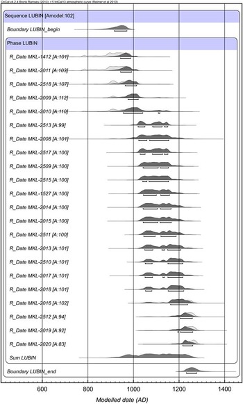
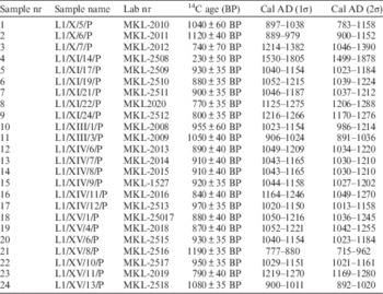
Twenty-four samples of charcoal and organic substances collected from the trenches situated outside the church’s relics were selected for 14C analyses, and the results are listed in Table 1. Among the analyzed samples, one turned out to be modern, while the 14C age of another one (L1/XV/8/P) was distinctly older than in samples from adjacent deposits, which is why they were both ignored in the determination of the chronological span of the medieval occupation. As there are no hints of a settlement gap, the chronology of the deposits within the stronghold was determined using a model allowing for the calculation of the probability distribution for the beginning, the end and the possible time span of the phase in calendar age (Figure 7). The results of this model indicate that the beginning of the medieval phase can be dated with 68.2% probability to the 10th century (916–971 cal AD), while its end falls in the 13th century (1232–1277 cal AD).
14C datings of the samples collected from the deposits situated outside the church’s relics. The sum of probabilities calculated with the software OxCal4.2.

14C dates for samples from the deposits of the Lubin stronghold (roman numerals in sample names indicate the number of excavation unit; the location of the latter is presented in Figure 2).

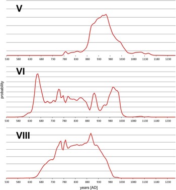
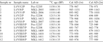
The results of the 14C analysis of 12 samples collected from the church’s relics proved quite surprising in the context of the dating of the samples presented above. They were collected from the trench beneath the foundation of the southern wall (charcoal-saturated deposit), from the charcoal concentration being the remains of vertical posts set on the foundation of the southern wall, and from the destruct of the church’s northern wall (Table 2). Figure 8 presents the sum of probability distributions for particular parts of the church’s relics calculated from all the dates. It is striking that in each of the investigated zones charcoals produced similar dates, but which were clearly older than expected based on historic data. The probability distribution suggests that the wood used for the construction of the church’s walls was cut in the first half of the 11th century at the latest.
The sum of probabilities for the 14C datings of the samples collected from the church’s relics, listed in Table 2 (roman numerals indicate the designations of archaeological trenches).

14C dates for samples from the relics of the church (samples 1–3: the trench beneath the foundation of the southern wall; samples 4–6: the remains of vertical posts set on the foundation of the southern wall; samples 7–12: the destruction of the northern wall; roman numerals in sample names indicate the number of excavation unit; the location of the latter is presented in Figure 2).

This result also hugely disagrees with the chronology established based on traditional archaeological methods, presented earlier in the text. The chronology established based on charred wood is much older, with a difference of at least 100 yr. It is symptomatic that the youngest charcoals (sample L1/V/8/P, MKL-2005), which may originate from the 12th century, were found in the trench, which means in a stratigraphic unit, which theoretically should be the oldest. It should be noted that the dating of the charred timbers from the church points to a significant chronological interval covered by annual growth rings from the investigated structural elements. They were probably made from old oak trees, whose individual age could have reached over 300 yr. This is not particularly uncommon, as oak forests 400–500 yr old can be found in the Wolin Island even today (Ważny Reference Ważny1990; Cedro Reference Cedro2004). It is noteworthy that, due to the fine texture of their wood, these oaks do not reach monumental sizes. However, taking into account that we have no single dates but a whole series of dates, a series which meets the criteria of representativeness with regard to both the number and the distribution of samples originating from different parts of the building, the explanation that the church was built from the wood of more than 300-yr-old trees seems insufficient. We would have to accept that every time a beam was being prepared, no less than several dozen of the youngest growth rings were consistently removed, which finds no practical justification in the case of timber framed walls filled with wattle.
It is much more likely that older construction timbers were reused when building the church. Such solutions in the discussed period are confirmed by an interesting account by Saxo Grammaticus, concerning the capture of Arkona by the Danes in 1168. After burning down the temple of Svantovit, a wooden church was erected in its place, built from timbers from the siege machines (Saxo Grammaticus Reference Olrik and Raeder1931: 39,34).
A similar situation most likely took place in the case of the Lubin church. Oak wood originating from old trees cut down at least 100 yr before was secondarily used during the construction of the church.
The secondary use of timber is complicated to prove by 14C analysis. This is illustrated by the discussed case of one of the oldest churches in Pomerania, whose construction is well attested by historic sources (VP Reference Wikarjak and Liman1966; Herbord Reference Wikarjak and Liman1974). Without precise information about the moment when the church was erected, the interpretation of the obtained results would not have been so unambiguous.
ACKNOWLEDGMENTS
The study was supported by Narodowy Program Rozwoju Humanistyki (National Programme for the Development of Humanities), grant no 0212/NPRH2/H11/81/2013, “Ujście Odry we wczesnym średniowieczu. Wolin i Lubin – edycja źródeł archeologicznych.”