


Introduction
Humans have always been on the move. From the dispersal of Homo sapiens out of Africa and the expansion of farming populations to contemporary international migrations, large-scale population movements have played pivotal roles in precipitating cultural transformations throughout human (pre)history. In South America, from initial colonisation (c. 15 000 BC) to the expanding territory of the Inka Empire (AD 1438–1525), migrations have contributed to the continent’s rich cultural and linguistic diversity (Eriksen Reference Eriksen2011; Schillinger & Lycett Reference Schillinger and Lycett2019). The extensive geographic distribution of societies associated with the Tupí languages, spanning millions of square kilometres within the South American lowlands, has engendered debates and dialogues between historical linguists (e.g. Rodrigues Reference Rodrigues2000; Walker et al. Reference Walker, Wichmann, Mailund and Atkisson2012; O’Hagan et al. Reference O’Hagan, Chousou-Polydouri and Michael2019; Gerardi et al. Reference Gerardi, Tresoldi, Coelho Aragon, Reichert, Souza and Noelli2023) and archaeologists (Brochado Reference Brochado1984; Noelli Reference Noelli1998; Corrêa Reference Corrêa2014; Almeida & Neves Reference Almeida and Neves2015; Bonomo et al. Reference Bonomo, Angrizani, Apolinaire and Noelli2015; Noelli et al. Reference Noelli, Brochado and Corrêa2018; de Souza et al. Reference de Souza, Noelli and Madella2021) regarding a protracted history of population movement and cultural diversification. The remarkable geographic expanse of Tupí-speaking horticulturists across the Amazon and La Plata basins and the Brazilian Atlantic coast reflects cultural persistence and differentiation over at least five millennia.
Here, we evaluate temporal and spatial distribution patterns of the two main Tupí-related and archaeologically identified groups, the Guaraní and the Tupinambá. Both are canoe-horticulturalist societies that thrived beyond the confines of the Amazon basin during the Late Holocene. Our analytical framework involves an extensive archaeological dataset encompassing more than 660 dates and the development of a mobility model using Geographic Information Systems (GIS) in conjunction with network analysis tools. This model encompasses the river-system basins and the Atlantic slope, thereby forming a comprehensive mobility network.
Since the 1960s, multiple hypotheses about the origin and dispersal of Tupí have emerged. The geographic origin hypothesis (Figure 1a) primarily relies on insights from historical linguistics, initially involving the comparison of cognate words (i.e. words from different languages that are similar in form and meaning because they derive from a shared ancestral root). These studies suggest a common origin for the Tupí (=Tupían) linguistic family at approximately 3000 BC within the Upper Madeira basin in the south-western Amazon (Rondônia state; Rodrigues Reference Rodrigues1964, Reference Rodrigues2000, Reference Carlin and van der Kerke2010; Rodrigues & Cabral Reference Rodrigues, Cabral, Campbell and Grondona2012; Walker et al. Reference Walker, Wichmann, Mailund and Atkisson2012). This region boasts the highest concentration of Tupí linguistic branches and isolated languages. The Guaraní and Tupinambá languages belong to the largest Tupí-Guaraní branch, which underwent differentiation in the south-eastern Amazon, where the greatest linguistic diversity within this branch and the closest linguistic relatives, Awetí and Mawé, are found (Mello & Kneip Reference Mello and Kneip2005; Rodrigues & Cabral Reference Rodrigues, Cabral, Campbell and Grondona2012; Walker et al. Reference Walker, Wichmann, Mailund and Atkisson2012; O’Hagan et al. Reference O’Hagan, Chousou-Polydouri and Michael2019). More precisely, Tupí-Guaraní had developed by at least 500 BC in the Tapajós-Xingu interfluve, as indicated by language phylogenies inferred from lexical data, and the ancestors of the Guaraní and Tupinambá likely diverged in this region (Gerardi et al. Reference Gerardi, Tresoldi, Coelho Aragon, Reichert, Souza and Noelli2023; Figure 1b).
Hypotheses of the origin and dispersal of Tupí farmers, based on: a) historical linguistic and archaeological evidence (Rodrigues Reference Rodrigues1964, Reference Rodrigues2000; Meggers et al Reference Meggers, Dias, Miller, Perota., Vanzolini and Heyer. 1988; Walker et al Reference Walker, Wichmann, Mailund and Atkisson. 2012; O’Hagan et al Reference O’Hagan, Chousou-Polydouri and Michael. 2019); b) lexical changes within the Tupí-Guaraní branch (Gerardi et al Reference Gerardi, Tresoldi, Coelho Aragon, Reichert, Souza and Noelli. 2023); c) archaeological data (Lathrap Reference Lathrap1970; Brochado Reference Brochado1984) (figure by authors).

Drawing on archaeological data, another hypothesis (Figure 1c) suggests the Central Amazon as the region of origin for the Tupí (Lathrap Reference Lathrap1970; Brochado Reference Brochado1984). This proposition is rooted in the shared characteristics of the extensive Amazonian Polychrome Tradition (Howard Reference Howard1947), which is linked to the Tupí (Brochado Reference Brochado1989) and characterised by pottery decorated with red and black paint on a white base and the use of urns for human burials. For Brochado (Reference Brochado1984), following Lathrap (Reference Lathrap1970), the environmental richness of the Amazon generated population growth and dispersion in search of new farmlands; the Guaraní dispersing southwards along fluvial systems to the La Plata basin and the Tupinambá emerging from the Amazon mouth and following the Brazilian Atlantic coast south. The groups then met around the year AD 1000 in São Paulo and Paraná states. In contrast, Meggers (Reference Meggers and Prance1982) saw migration as the consequence of aridification that fragmented the tropical forest, leading to a scarcity of resources and crop failure. Under this model, ‘environmental migrants’ followed the routes proposed by linguistic studies (Figure 1a; Meggers et al. Reference Meggers, Dias, Miller, Perota., Vanzolini and Heyer1988), supported by rare but ancient (3000–2000 BC) archaeological sites in the south-western Amazon (Miller Reference Miller2009; Zimpel Reference Zimpel2018), with the Tupinambá only later migrating northwards along the Atlantic coast.
As archaeological, genetic and palaeoenvironmental research has advanced, dispersion hypotheses have grown more intricate. For instance, the Southern Amazonian Tupí origin has been corroborated by genomic data (Silva et al. Reference Silva2020), while the concept of a Central Amazon homeland has been revised (Noelli Reference Noelli1998) and discredited (Heckenberger et al. Reference Heckenberger, Neves and Petersen1998). Additionally, it is now established that the Amazonian Polychrome Tradition is not earlier than the Tupinambá/Guaraní archaeological entities (Almeida & Neves Reference Almeida and Neves2015). Polychrome pottery is also found in other Amazonian ceramic traditions associated with non-Tupí populations, indicating long-standing circulation and intercultural exchange of technological practices. The forest refuges model (Meggers et al. Reference Meggers, Dias, Miller, Perota., Vanzolini and Heyer1988) was abandoned; instead, an increase in rainfall and consequent expansion in tropical forests during the past 3000 years are associated with constant growth in the number of Guaraní sites (Iriarte et al. Reference Iriarte2017). Hence, it is likely that population dispersal was facilitated by the expansion of forests, where polyculture agroforestry could be practised (de Souza et al. Reference de Souza, Noelli and Madella2021). Building on earlier work on the dispersal of the Guaraní people (Bonomo et al. Reference Bonomo, Angrizani, Apolinaire and Noelli2015), this article aims to gain a better understanding not of the origins but of the possible routes and directions taken by the Guaraní and the Tupinambá, based on the available empirical evidence.
The spatial distribution of archaeological and ethnohistorical records reveals distinct territories for Tupinambá and Guaraní horticulturists (Brochado Reference Brochado1984; Noelli Reference Noelli1998). The Tupinambá occupied the region from the mouth of the Amazon to the Atlantic coast of the Paraná state, while the Guaraní were found along the La Plata basin and the southern Brazilian coast; the boundary between them lying along the Paranapanema and Tietê rivers in Brazil. Pottery technological styles also differed (see Métraux Reference Métraux1927; Brochado Reference Brochado1984; Prous Reference Prous, Prous and Lima2010; Corrêa Reference Corrêa2023). In general, Tupinambá sites show abundant painted vessels (dominant internal painting) with spherical morphologies, quadrangular or elliptical mouths and rounded or occasionally conical bases. Guaraní pottery exhibits predominant corrugated external surfaces, external painting, stepped shoulders, complex morphologies, circular mouths and conical bases. These stylistic and morphological traits shaped the material dimension of the Guaraní and Tupinambá expansion.
Materials and methods
To assess the timing, plausible routes and distances of the Guaraní and Tupinambá expansions, we compiled published dates from 356 georeferenced archaeological sites (Figure 2; see online supplementary material (OSM) 1 & 2). It is important to clarify that the Guaraní and Tupinambá categories are conceptual constructs derived from archaeological and ethno-linguistic data, which overlap geographically and span from prehistoric to historic periods. Despite this temporal continuity, the cultural correlation is neither direct nor unambiguous; rather, it is dynamic and fluid over time. We employ these categories as archaeological entities as we focus on information derived from the archaeological record. We also include other Tupí occupations whose archaeological records are not associated with historically or linguistically documented populations. To avoid the use of the generic ‘Tupiguarani’ label, the term ‘other Tupí’ is used here as an operational category, emphasising the diversity within the Tupí linguistic family, which comprises ten branches and over seventy distinct languages. This category does not represent an archaeological entity equivalent to the Guaraní or Tupinambá categories. For this reason, it is not applied across all analyses presented here. Moreover, using sites in this category—widely dispersed across an enormous area and spanning a vast temporal range—to model directional trends over such an extensive space would render the results highly speculative.
Geographical distribution of Tupí archaeological sites in South America (n = 355) (figure by authors).
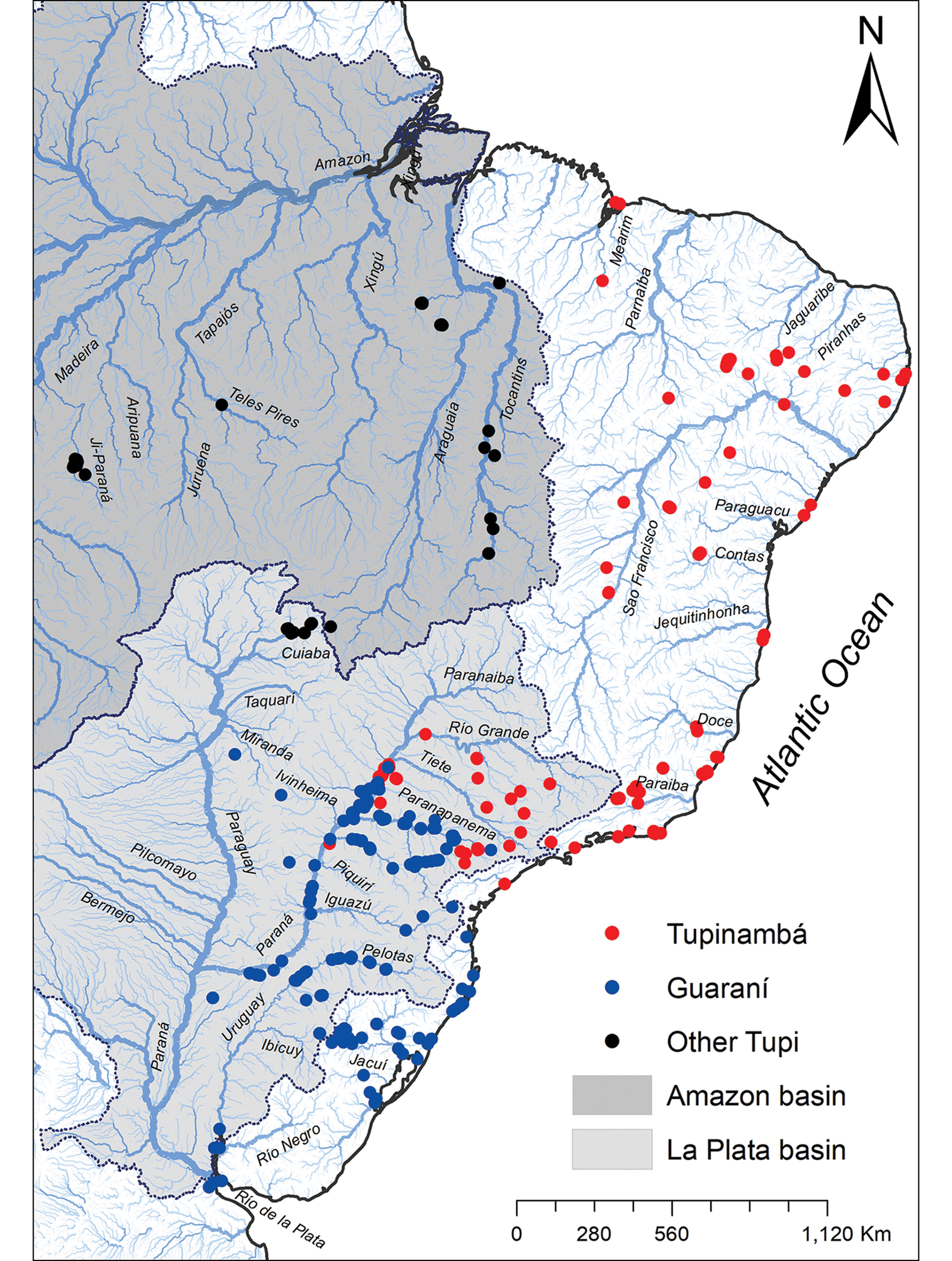
We analyse dates from sites that have been classified by excavators or subsequent researchers based on their shared material culture traits (such as ceramic style, lithic technology, subsistence, settlement patterns and funerary practices) within these archaeological entities. Two of the authors (AAC & FSN) reanalysed a substantial portion of their ceramic collections across more than 50 Brazilian institutions. The Tupinambá dataset comprises 126 sites with 219 radiocarbon, thermoluminescence and relative dates (associated with European glass, stoneware, majolica, brass and iron), ranging from 80 BC to AD 1750, located within present-day Brazil. The Guaraní dataset includes 352 dates from 197 sites across Argentina, Brazil and Uruguay, spanning AD 27–1750. These modern chronological limits are arbitrary and linked to dating methods, as migrations continued through the nineteenth and twentieth centuries (Métraux Reference Métraux1927) and still occur today between country borders (Bartolomé Reference Bartolomé2009). The ‘other Tupi’ category is under-represented here and includes only 95 dates from 33 sites, spanning from 3834 BC to AD 1777. This dataset of 666 radiocarbon ages derives from previous compilations (Brochado Reference Brochado1984; Noelli et al. Reference Noelli, Milheira, Wagner, Milheira and Wagner2014; Bonomo et al. Reference Bonomo, Angrizani, Apolinaire and Noelli2015; Corrêa Reference Corrêa2017; de Souza Reference de Souza2021).
The dates were calibrated at 1σ and converted to calendar years (using OxCal v.4.4 and the SHCal20 curve; Hogg et al. Reference Hogg2020; Bronk Ramsey Reference Bronk Ramsey2021; see OSM2 for details) and geographically pinned using ArchGIS. The statistical significance of all dates and their spatial autocorrelation was analysed using the Getis-Ord Gi statistic to assess the likelihood of early date aggregation. The dataset was then narrowed to include only Guaraní and Tupinambá dates. To visualise Guaraní and Tupinambá mobility according to the chronological order of their associated dates, a transport network model was constructed from contemporary hydrographic data (Lehner & Grill Reference Lehner and Grill2013) using ArcGIS 10.5 Network Analyst (ESRI), following the procedures described by Apolinaire & Bastourre (Reference Apolinaire, Bastourre., Brughmans, Mills, Munson and Peeples2023; see OSM2 for details).
Results
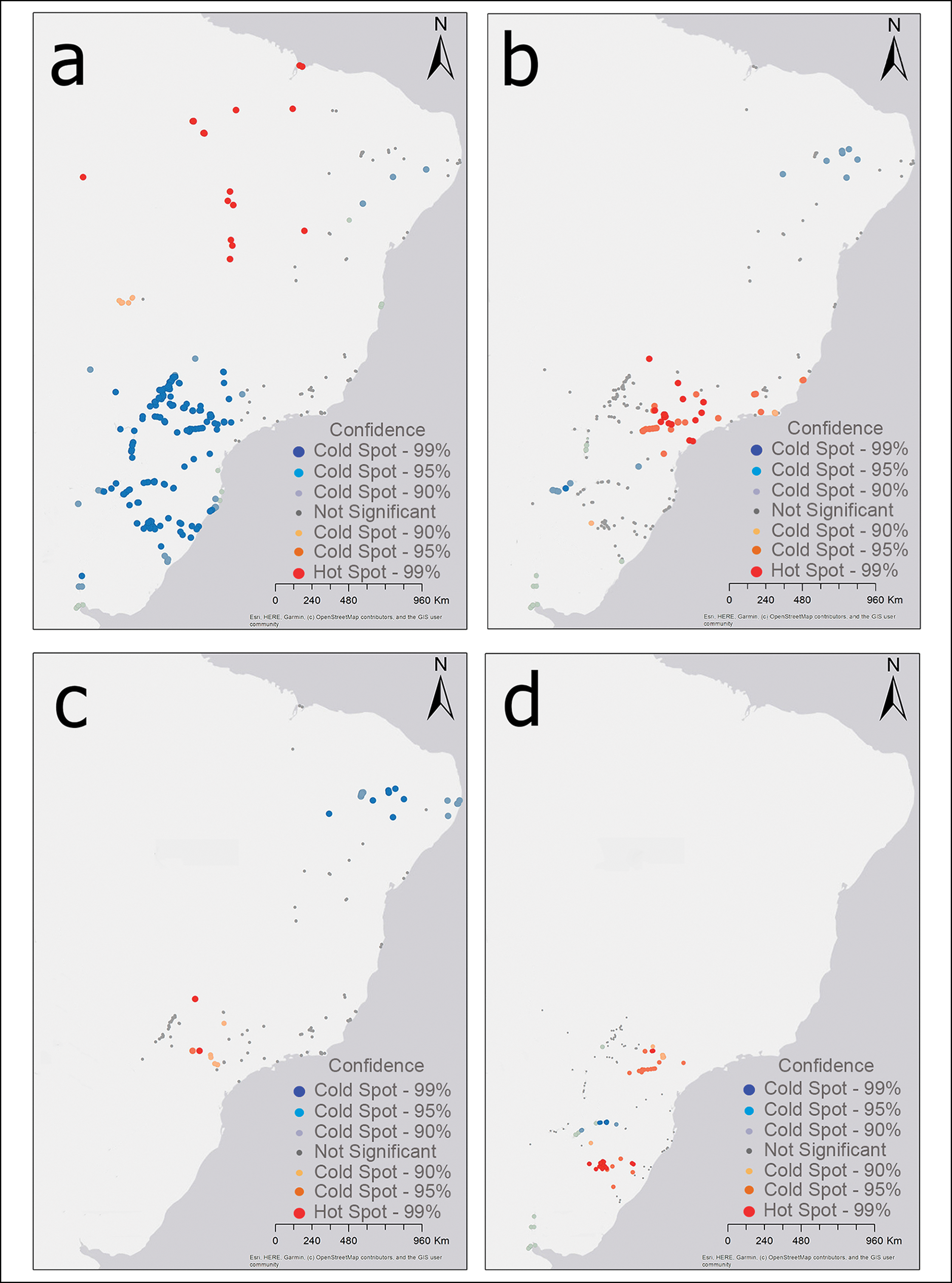
To link our chronological database with the widespread expansion of the Tupí peoples, we first consider the simplest possible non-directional dispersion model. Geostatistical probabilities predict that, if there were a central point of origin, earlier settlements should form spatial clusters, while later settlements should exhibit greater spatial dispersion. Consequently, spatial locations with stronger date-distance correlations should correspond to the earliest inhabited areas. Spatial autocorrelations, which gauge these groupings, reveal that in an examination of all Tupí sites, older date clusters are situated in several locations along the south-western and south-eastern Amazon basin, specifically in Rondônia, Tocantins and Maranhão states (Figure 3a). However, when we narrow our focus to the Guaraní and Tupinambá data, early sites cluster in the Alto Paraná basin (Figure 3b). This location encompasses early sites of both the Tupinambá (in the lower Tietê and the middle Paranapanema rivers; Figure 3c) and the Guaraní (in the middle course of the Ivaí and Paranapanema rivers; Figure 3d). The later Tupinambá sites are located in north-eastern Brazil, while the later Guaraní sites are found along the Uruguay River, extending to the La Plata River.
Localisation of statistically significant spatial clusters of early dates (hot spots in red) and late dates (cold spots in blue): a) Tupí; b) Tupinambá and Guaraní; c) Tupinambá; d) Guaraní (figure by authors).
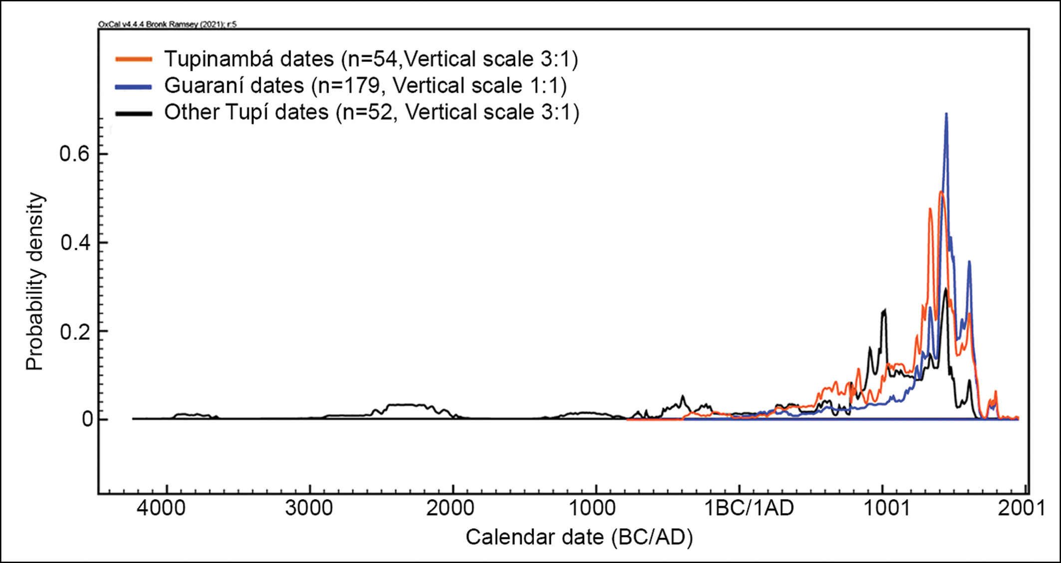
Every alternative considered in this analysis aligns with the notion of an origin outside our study area, likely situated in the Amazon region, where archaeological sites categorised as ‘other Tupí’ are found. This is readily apparent in Figure 4, where the cumulative probabilities of the calibrated radiocarbon dates show that Tupinambá and Guaraní are approximately contemporaneous. In contrast, dates attributed to ‘other Tupí’ are older and exhibit a greater dispersion.
Combined probability distributions of radiocarbon dates from Tupí archaeological sites. Dates extending outside the calibration curve are not considered in the probability distribution (figure by authors).
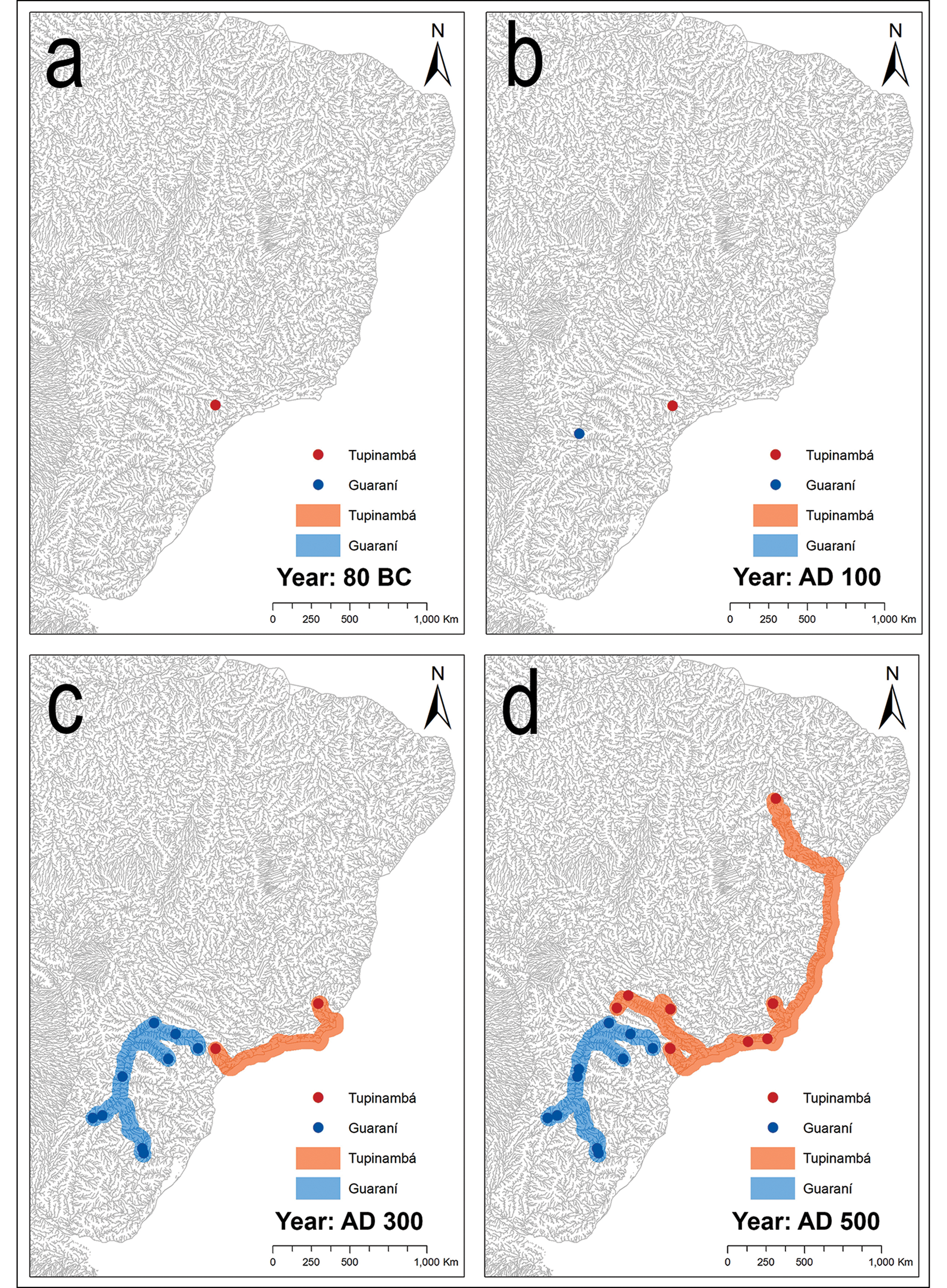
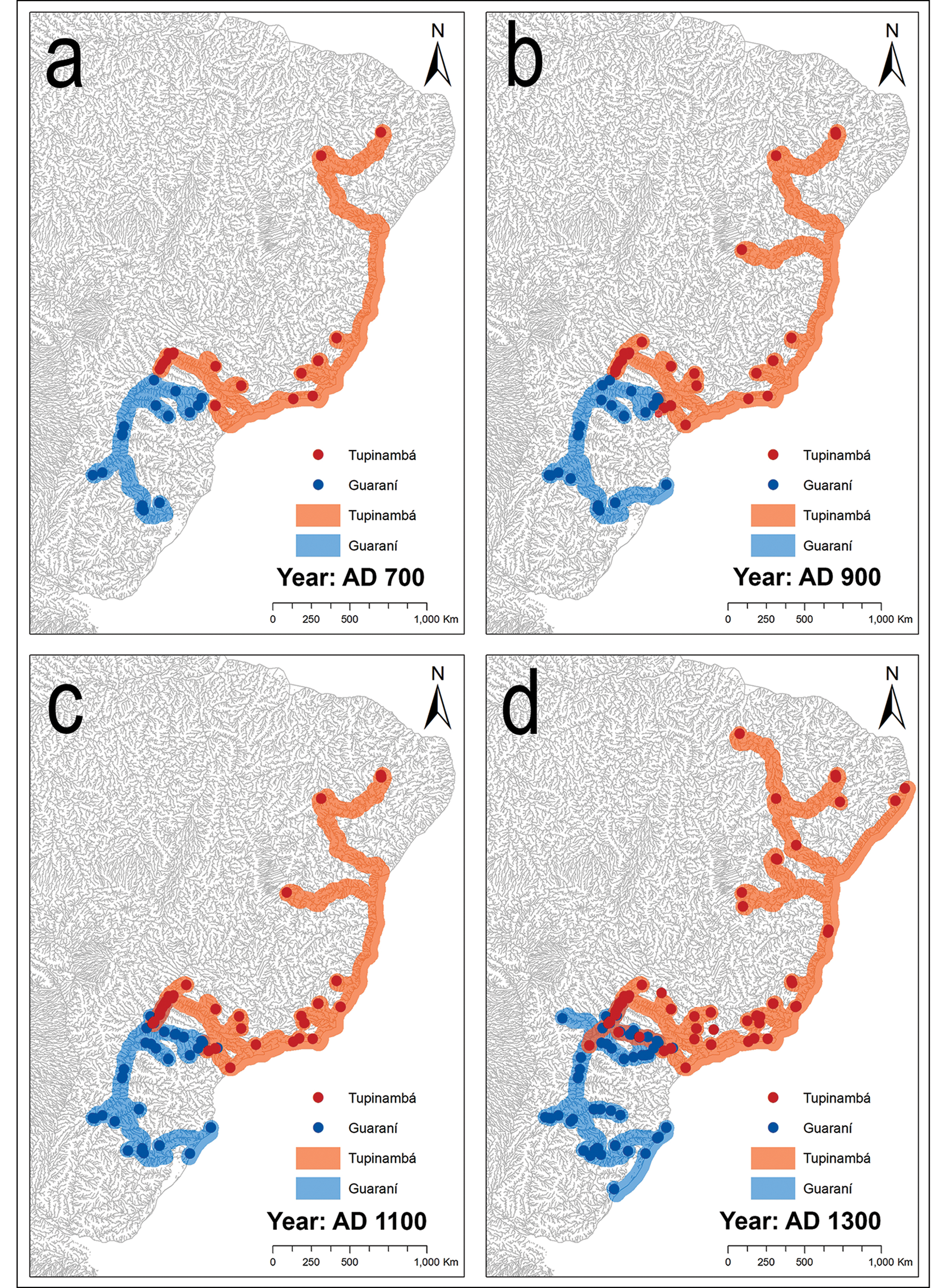
To understand how the dispersal of the Tupinambá and Guaraní may have occurred, we have developed an animated representation (see OSM 3, summarised in Figures 5, 6 & 7). This starts with the Tupinambá at the headwaters of the Paranapanema River, in the La Plata basin, as early as c. 80 BC (Panema archaeological site) (Figure 5a). About 100 years later, the Guaraní movements initially centred around the mouth of the Iguazú River in the same basin (Fazenda Dona Carlota 2 site, c. AD 30) (Figure 5b). Over the subsequent three centuries, the Guaraní exhibited a substantial territorial expansion, spanning more than 1500km. They followed the course of the Paraná River both north and south, as well as the Paranapanema, Ivaí and Ibicuí rivers east and south (Figure 5c). The Tupinambá settled along the Atlantic coast of Rio de Janeiro during the late second century and further movements appear to be minimal until the end of the fourth century, when an expansion pulse is documented (Figure 5d). The establishment of settlements in the upper Paraná region is observed in the vicinity of the mouth of the Tietê River (c. AD 350), signifying an advancement of approximately 700km to the north-west. Subsequently, new settlements are identified along the Piauí River, located 2300km to the north (AD 395). These substantial distances may suggest that research bias could be contributing to the absence of dated early Tupinambá sites in a vast region of eastern Brazil. During the fifth to tenth centuries, occupations in the same areas persisted, with minor expansions by the Guaraní towards the Atlantic coast (c. AD 905) and by the Tupinambá inland as far as the São Francisco basin (AD 825) (Figure 6a & b).
Dispersion model highlighting occupied areas from 80 BC to AD 500: a & b) the earliest dates for the Tupinambá and Guaraní considered here occur between 80 BC and AD 27; c) the first recorded expansion for both Tupinambá and Guaraní settlements; d) Tupinambá expansion inland and along the coast to the north (figure by authors).
Dispersion model highlighting occupied areas from AD 700–1300: a) a period of stability followed by a little dispersion pulse (b) for both Tupinambá and Guaraní sites; c & d) minor dispersion occurred until two centuries before the arrival of European populations (figure by authors).
Dispersion model highlighting occupied areas from AD 1500–1700: a) final territorial expansions before the European conquest; b) the final stability period was followed by a cessation of archaeologically registered movements during colonial times (figure by authors).
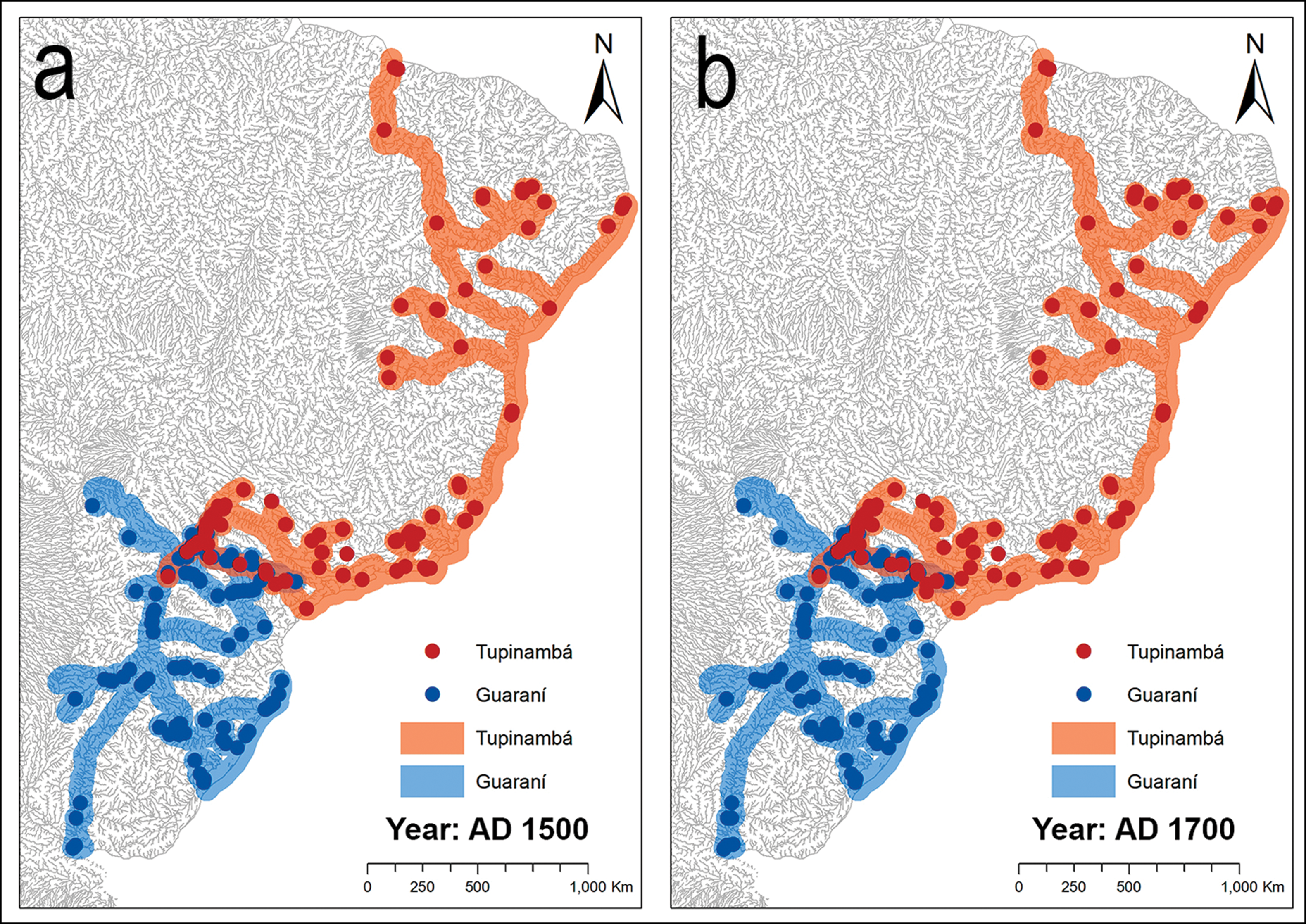
Between the eleventh (Figure 6c & d) and fifteenth centuries (Figure 7a) another pulse of expansion is apparent. The Guaraní spread 2000km southward along the Atlantic coast, reaching the Uruguay River, and extended north-west through the Ivinhema Basin to the Miranda River. Meanwhile, the Tupinambá covered more than 2000km to the north along the Atlantic coast, crossing the Parnaíba and Mearim rivers up to their mouths. To the south, multiple Tupinambá sites were identified in Paranapanema, where Guaraní sites had already been present since the second century. Further field studies are necessary to specify the nature of contact between both groups along the Paranapanema River during pre-Hispanic times. The Guaraní reached the southernmost extent of their distribution in the Paraná Delta and the La Plata River during the fourteenth to fifteenth century. With the arrival of the Spanish and Portuguese, new archaeological sites continued to be formed during the sixteenth century, primarily within the already settled regions, but the scale of expansion dwindled as some ancestral coastal and riverine territories were encroached upon by Europeans (Figure 7b).
Discussion
As we lack information on European settlements such as religious missions, forts or trading posts, our dataset provides little illumination on migrations in the South American historic period (post-AD 1500). Ethnohistorical data indicate the movement of the Guaraní and Tupinambá peoples towards previously uninhabited areas (e.g. the area between the mouth of the Amazon and São Luís Island, Maranhão), often as a direct response to the European colonisation process. At least 13 migrations in the study area have well-documented points of departure and arrival and led to destinations not predetermined by Europeans (i.e. on reservations or religious missions) (Métraux Reference Métraux1927). These migrations covered an average distance of 800km in a straight line (ranging from approximately 150–1900km) along the coast of Brazil and the La Plata basin between AD 1410 and 1890. During the fifteenth century, five distinct major migrations of the Tupinambá are documented, aligning with the increased movements identified at the end of the precolonial period in this article. With this articulation of ethnohistoric and archaeological evidence, we do not seek to project data from these historical migrations back into earlier periods. However, noting that even geographically distant Tupi-Guaraní speaking groups reacted in similar ways, Almeida (Reference Almeida2015) argues that the possibility of rapid, long-distance migrations also occurring during the long periods of past expansions into new territories cannot be ruled out.
The Guaraní data (Figure 8) align with trends from our previous model (Bonomo et al. Reference Bonomo, Angrizani, Apolinaire and Noelli2015), which shares several similarities with Brochado’s (Reference Brochado1984) hypothesis. There are, however, two important points of difference: the Paraná River was not utilised as an expansion route downstream of the confluence with the Paraguay River, and there is no evidence for an early migration via the Paraguay River. While there are some late ‘other Tupí’ occupations in the Paraguay basin, particularly along the Vermelho River (Wüst Reference Wüst1999), extensive field investigations conducted by Migliacio (Reference Migliacio2006) in the Pantanal of the upper Paraguay River have not revealed any remains associated with the Guaraní or other Tupí groups. This lack of data weakens the hypothesis that the Guaraní initially entered the La Plata basin through the Guaporé-Paraguay corridor. Additionally, despite the presence of late Guaraní materials in Bolivia (Alconini Reference Alconini, Alconini and Betancourt2015), the proposed early Guaraní dates in the mountain ranges adjacent to the Bolivian Chaco require systematic excavations for proper evaluation (Pärssinen Reference Pärssinen2005: 57). It is also crucial to consider the regional use of corrugated pottery by non-Guaraní populations (Susnik Reference Susnik1972). In exploring alternatives for the expansion of the Guaraní ancestors, Corrêa (Reference Corrêa2014, Reference Corrêa2023) proposes that they initially spread into areas adjacent to the Tupí-Guaraní centre of origin in the eastern Amazon, with a preferential southward movement through the Tocantins and Araguaia basins, before ultimately progressing to the La Plata basin.
Proposed model of past dispersions of Guaraní and Tupinambá (figure by authors).

Brochado (Reference Brochado1984) proposed a coastal southern dispersion for the Tupinambá based primarily on a single early date from c. AD 260. We now identify older dates along the Paraná basin and the Rio de Janeiro coast that cannot be explained by this hypothesis (Figure 8). Our data align with results from other authors, who also suggest that the Tupinambá presence in north-eastern Brazil is more recent (Albuquerque Reference Albuquerque, Prous and Lima2008; Dias & Panachuck Reference Dias, Panachuk, Prous and Lima2008; Lima Reference Lima, Prous and Lima2010), following a northward dispersion along the Brazilian coast (Meggers et al. Reference Meggers, Dias, Miller, Perota., Vanzolini and Heyer1988; Rodrigues Reference Rodrigues2000).
Yet, much regarding the expansion of the Tupinambá remains to be addressed, particularly concerning interactions in the lower Amazon basin. For instance, studies of ceramic assemblages (Brochado Reference Brochado1984; Corrêa Reference Corrêa2014, Reference Corrêa2023) propose that the ancestors of the Tupinambá expanded from the eastern Amazon to the north-east Atlantic coast; support for or refutation of this will require more radiocarbon dates from north-eastern Brazil. Regions with greater research intensity tend to yield older dates, potentially introducing sampling biases (Corrêa & Samia Reference Corrêa and Samia2006; Scheel-Ybert et al. Reference Scheel-Ybert, Macario, Buarque, Anjos and Beauclair2008; Corrêa Reference Corrêa2017), although this imbalance is gradually being corrected. Moreover, it is also important to consider a potential north–south movement pattern.
Spatial autocorrelations reveal that early dates associated with all Tupí sites also cluster in the south-eastern Amazon rainforest, in the interfluvium between the Xingu and Tocantins rivers. Our model is not the first to highlight this region (e.g. Almeida & Neves Reference Almeida and Neves2015), which partially coincides with origin of the Tupí-Guaraní linguistic branch (Mello & Kneip Reference Mello and Kneip2005; Gerardi et al. Reference Gerardi, Tresoldi, Coelho Aragon, Reichert, Souza and Noelli2023). Furthermore, ceramic assemblages that may be morphological and stylistic precursors to the Tupinambá are found to the east of this region (Corrêa Reference Corrêa2014, Reference Corrêa2023). Such evidence cannot resolve the chronological gap of over 1.5 millennia between these early dates and the nearest Tupinambá sites in north-eastern Brazil, and the oldest Tupinambá sites are separated by 2000km.
Figure 9 illustrates the dispersion patterns of the Tupinambá and the Guaraní over time. By plotting the cumulative linear expansion for each century, we can observe distinct pulses of rapid dispersion followed by periods of relative stability. Notably, there are expansion pulses during the middle of the first millennium AD and later in the second millennium, and dispersion patterns for the Tupinambá and Guaraní largely follow a similar rhythm. These pulses are separated by periods of stasis or slower expansion.
Expansion pulses measured in linear kilometres. The first and second Tupinambá expansion pulses are recorded before and after the first Guaraní expansion pulse. Between AD 500 and 1500 the expansion recorded for both archaeological entities occurs synchronously (figure by authors).
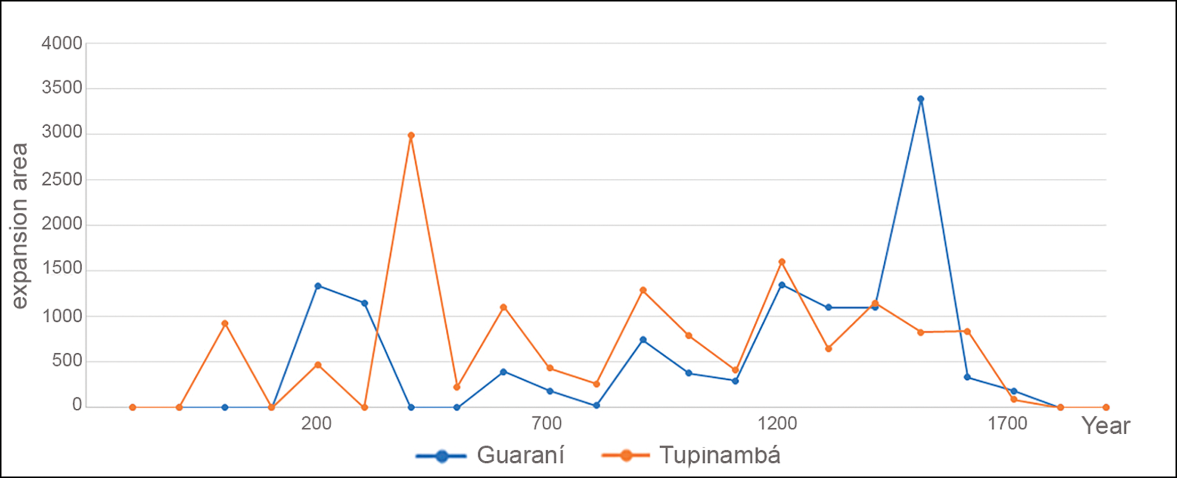
One possible explanation for similarities in the dispersion rhythms of Guaraní and Tupinambá populations could be found in palaeoenvironmental changes. Iriarte and colleagues (Reference Iriarte2017) propose that wetter conditions occurring during the past 3000 years in the Late Holocene favoured the expansion of agroforest horticulture. De Souza and colleagues (Reference de Souza, Noelli and Madella2021) further support this hypothesis with simulations of land cover, suggesting that environmental causes are still the best explanation for the pattern of Tupí settlement found outside of the Amazon rainforest. The spatial and temporal scale of analysis is important when assessing these factors. In the long-term and at a continental scale, the more humid conditions with forest expansion, which increased resource availability and the richness of the soil, were a likely driver of Tupí dispersion. Nevertheless, the cyclicality observed in our time series (see also Bonomo et al. Reference Bonomo, Angrizani, Apolinaire and Noelli2015)—with moments of expansion and relative stability—is not entirely accounted for by those long-term changes, suggesting that other sociocultural factors may also have influenced the pulse-stability rhythms of dispersion.
Endogenous behaviour may be one such factor. Corrêa (Reference Corrêa2014) proposes an organic growth model with two kinds of expansion movements: homeostatic and heterostatic. The homeostatic movement is slow, represented by the foundation of new villages and camps near parental ones, maintaining connections between them and resulting in regional constellations. Implicit in this movement type is landscape domestication, consolidation of cultural networks and growth of population density. High population density could lead to the division of one or more communities, which would eventually separate over greater distances (heterostatic movement), accelerating the pace of geographical expansion. This generates a new population nucleus that then gives rise to further homeostatic movements of populations that gradually differ from their ancestral population. This proposal could account for the patterns shown in Figure 9, as it predicts moments of stability when population density grows locally, followed by expansion pulses. However, this endogenous process explains the process of how expansion could occur, but it does not assess why it occurred.
Population expansion did not unfold within vacant landscapes but necessitated the transgression of cultural frontiers. Hence, an additional external factor influencing these expansions pertains to the distribution of other groups. The interactions between incoming and Indigenous communities likely entailed processes of ethnogenesis, alliance, exchange or confrontation. Irrespective, such interactions inevitably exerted influence on the velocity and trajectory of expansion, hindering, delaying or propelling expansion through populated areas. Archaeological and ethnohistorical evidence (Klokler et al. Reference Klokler, Almeida, Bowser, Botelho and Camargo2021) indicates that the Tupinambá expelled different coastal groups, such as the early fisher-gatherers of Maranhão Island. Despite their territorial gains, the Tupinambá were unable to displace all Indigenous inhabitants of the coast, and some Macro-Jê speakers, like those of present-day Ceará, successfully resisted their conquest along the coast (Klokler et al. Reference Klokler, Almeida, Bowser, Botelho and Camargo2021: 94–95). This phenomenon is also evident in ethnohistorical accounts of the Guaraní, where encounters with other groups (e.g. Kaingang; Métraux Reference Métraux1927) forced them to search for alternative territories, sometimes leading to the displacement of the original inhabitants along these secondary routes (Noelli 2005). The Taquara-Itararé employed funerary monuments to establish an impermeable frontier to resist the Guaraní on the Brazilian Planalto border (de Souza et al. Reference de Souza, Corteletti, Robinson and Iriarte2016).
In the southern Paraná River region, associated with the Goya-Malabrigo archaeological entity (Politis & Bonomo Reference Politis and Bonomo2023) and the mound-builders of eastern Uruguay and southern Brazil (Milheira & Gianotti Reference Milheira and Gianotti2018), Guaraní artefactual assemblages are sparse or entirely absent, indicating obstruction by local groups. This meridional region is crucial for understanding population expansion mechanisms because it is located at the southern border of the Guaraní territory. Unlike in other regions, where Guaraní occupation lasted millennia (e.g. the Upper Paraná basin), here their presence was limited to a few centuries, ultimately interrupted by the arrival of European populations. We therefore have an archaeological snapshot of this non-consolidated expansion process. The effective occupation of this relatively new territory is only observed in a small number of densely located sites characterised by domestic activities, a wide variety of vessels and several (at least 16) urn burials, indicating the establishment of some stable villages. Yet Guaraní individuals and objects circulated widely beyond the limits of these villages. Interethnic interaction is reflected in the isolated Guaraní vessels and pottery fragments found on the surface or mixed in the upper layers of many sites previously settled by other societies (Bonomo et al. Reference Bonomo, Angrizani, Apolinaire and Noelli2015). After this initial interaction, some Guaraní started to colonise the Upper Delta and surroundings, with a few sites showing the intentional occupation of places abandoned by other groups after the first arrival of Europeans.
Conclusions
Our archaeological study offers parameters for testing new interdisciplinary hypotheses pertaining to Tupí population dispersions across South America. Yet, better articulation between linguistic, palaeoenvironmental and archaeological research, including the establishment of more radiocarbon dates, remains imperative for furthering our understanding of the movements and interactions of early groups. Linguistic and genetic evidence indicates that the Tupí linguistic group originated in the Amazon Basin, but the scarce and scattered nature of archaeological data creates a disconnect between the ancestral Amazon-based dispersal and the dispersion of the Guaraní and Tupinambá outside of the basin. The earliest available radiocarbon dates suggest that the Tupinambá dispersion started c. 80 BC in the La Plata Basin and proceeded northwards; the Guaraní expansion seems to have started later, around AD 0, following river systems south and east. Despite their different pathways, the dispersions of the Tupinambá and Guaraní exhibited relatively synchronous rhythms, highlighting shared cultural practices in the mechanisms of expansion. The stability-pulse rhythm of expansion does not appear to track palaeoenvironmental fluctuations and thus offers insights into the idiosyncratic expansion behaviour of these Tupí horticulturists and their interactions with other local groups.
Acknowledgements
To the reviewers and Antiquity’s editorial team, as well as Gustavo Politis, Fernando Almeida and Fernando de Carvalho, whose suggestions helped improve the contents of this article.
Funding statement
These investigations benefitted from the funding for three projects: PIP-CONICET 0126, PICT-0252 and FCT-2020.05745.
Online supplementary material (OSM)
To view supplementary material for this article, please visit https://doi.org/10.15184/aqy.2025.10148 and select the supplementary materials tab.



