
Introduction
By comparison with the Roman Empire, knowledge of Sasanian military expansion is still very limited. This is partly due to the relative paucity of historical sources, but also to the lack of related archaeological fieldwork. Although current fieldwork along the frontiers of the Sasanian Empire is contributing towards improving our knowledge, there is still much to be learned (Sauer et al. Reference Sauer, Omrani Rekavandi, Wilkinson and Nokandeh2013).
One region that attracted occasional Sasanian (AD 224–651) interest is Eastern Arabia, specifically Bahrayn (covering Bahrain/eastern Saudi Arabia) and ‘Uman (covering northern Oman and the UAE)—the latter of which is the focus of this article. It has been argued that these areas were important for the control of trade, defence of the western frontier and access to mineral resources (e.g. Piacentini Reference Piacentini1985, Reference Piacentini1992: 124–25; Morony Reference Morony2001–Reference Morony2002; Daryaee Reference Daryaee2003: 9). Early Islamic sources, however, suggest that the Sasanians launched expeditions into the region only when necessary. For example, according to Tabari, Ardashir in the early third century and Shapur II in AD 325, which may both have resulted in a period of formal control (Potts Reference Potts1990: 232–34, 239–41, Reference Potts2008; Bosworth Reference Bosworth1999: 15–16, 54–57). Indeed, ‘Uman was included in Shapur I's (AD 242–270) list of imperial possessions (Huyse Reference Huyse1999: vol. 1: 23–24, vol. 2: 38; Potts Reference Potts2008). The nature and durability of Sasanian control is, however, unclear and there is ambiguity about the degree to which ‘Uman in particular was affected (Potts Reference Potts1990: 330; Kennet Reference Kennet, Kennet and Luft2008: 55–56; Ulrich Reference Ulrich2011: 381). It was not until Khusraw I (AD 531–579) that indications of attempts at direct control emerge, for example, again in Tabari (Potts Reference Potts1990: 335–38, Reference Potts2008; Bosworth Reference Bosworth1999: 159, 237, 253). Prior to this, Sasanian control was exercised through the client Lakhmid dynasty at Hira in Iraq, but the extent and degree of their control is also unclear (Kister Reference Kister1968).
Archaeological evidence for this period in ‘Uman is problematic. Until recently, it was believed that ancient field systems marked a Sasanian-period apogee of agricultural development (Wilkinson Reference Wilkinson1977: 50, 130–33). A recent review of the archaeological evidence, however, challenges this by suggesting that the period is amongst the least represented in the region's archaeology, and that contemporaneous activity and population size was limited (Kennet Reference Kennet2007).
It is important to differentiate between ‘Sasanian-period’ activity—that is to say contemporaneous activity—and direct Sasanian activity itself. While archaeological evidence for Sasanian-period settlement is already sparse, there is no such evidence of direct Sasanian settlement in Eastern Arabia. Most of the reliable Sasanian-period evidence has only recently come to light and consists predominantly of scattered cairn burials belonging to a local tradition but containing occasional Sasanian artefacts. Their dispersed nature and lack of associated settlements suggest that they belonged to nomadic populations. Very few settlements are known: it is almost certain from historical sources that Sohar was occupied, although no incontrovertible archaeological evidence has yet been found (Wilkinson Reference Wilkinson and Taddei1979: 888–89; Kennet Reference Kennet2007: 97–100). Additionally, a few Early Sasanian-period fortified elite residences are known from Ed-Dur and Mleiha (UAE), which appear to have been abandoned by the third century AD, Kush and Khatt in Ras al-Khaimah (UAE), and Jazirat al-Ghanam in the Musandam. The site of Jazirat al-Ghanam comprises a few stone structures associated with Sasanian-period pottery, on a remote island, which may represent a Sasanian outpost (de Cardi Reference de Cardi1972). Kush and Khatt are more substantial agricultural settlements. Excavations at the former revealed a Late Sasanian-period occupation sequence (Kennet Reference Kennet, Phillips, Potts and Searight1998, Reference Kennet, Schiettecatte and Robin2009). The nature of the occupation is not clear; while arrowheads and chainmail suggest a military focus, it is impossible to identify the occupants.
Fulayj FJ3.S3
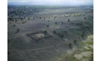
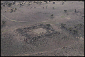
Despite the paucity of archaeological evidence, new sites are occasionally discovered. One such is the fort at Fulayj (FJ3.S3), not far from Sohar on the Batinah Coast of Oman (Figures 1 & 2).
Map of northern Oman and the UAE showing the location of sites mentioned in the text.

Kite aerial photograph of the Fulayj fort from the north-east (photograph: Mark Woolston-Houshold).

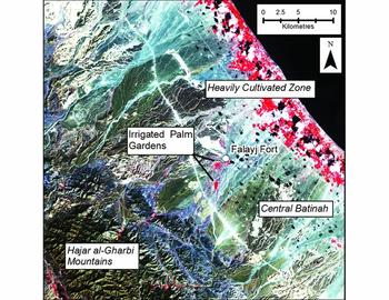
The site was discovered during the ‘Sahm Survey Project’ in 2012 and identified as of Sasanian period by the plan layout and surface pottery (al-Jahwari et al. Reference al-Jahwari, al-Muzini and al-Aghbari2014: 85–86, figs 4, 5, 11). Two seasons of excavation were undertaken by the European Research Council as part of the ‘Persia and its Neighbours’ project. The Batinah is a 240km-long coastal plain, most of which consists of uncultivable gravels, except for a narrow coastal band that has long been the main focus of settlement and agricultural production. Fulayj (FJ3) is a large archaeological site complex consisting mostly of Iron Age (1300–300 BC) remains on an inter-fluvial terrace on the Wadi al-Mahmum, 2km from the village of Falaj al-Harth. The site location is 13.5km from the coast at the point where the outwash plain develops more contoured terraces towards the mountains (Figure 3). It is associated with abandoned fields along the wadi channel, which appear to have been irrigated by run-off or aflāj (underground water channels).
Map showing the location of Fulayj. Based on a colour infrared Landsat 8 image (bands 5, 4, 3). Healthy vegetation appears bright red. Image courtesy of the US Geological Survey (map: Dan Lawrence and Kristen Hopper).

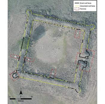
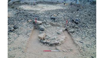
Fulayj is situated in the north of the Batinah, 30km south of Sohar, which historical sources indicate was important during the Sasanian period (Wilkinson Reference Wilkinson and Taddei1979). Just behind Sohar, the Wadi Jizzi was an important route to the interior. Copper is present in the area: recent work at Bronze Age Dahua, 11km to the south-west of Fulayj, has yielded evidence of ancient copper working (al-Jahwari pers. comm.). FJ3.S3 is located at the north-western end of the complex (UTM 40R 479290/2663670), and consists of a 30 × 30m square stone fort, oriented 14° north-north-east (Figures 2 & 4). The walls are approximately 2.65m thick and stand 0.4m above the present ground surface. It has four solid, U-shaped corner towers (Figure 5). There is a single, narrow eastern entrance 1.62m wide, flanked by rounded buttress towers (Figure 6). The top of the wall is levelled to a flat, even height all around, which, together with the limited stone tumble, suggests that the upper courses may have been mud-brick.
Annotated vertical kite photograph of the Fulayj fort showing the location of walls and trenches (photograph: Mark Woolston-Houshold; figure: Kristen Hopper).

Oblique view of the south-west corner tower in trench D, looking north-east.

Pole photograph of the entrance way (photograph: Kristen Hopper).

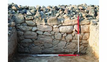
The plan is regular. The stone is not dressed, but has been carefully selected for flat faces and fine jointing, with large, irregularly coursed blocks packed with small stones bound with lime mortar (Figure 7). The quality of construction suggests experienced builders and careful planning.
View of the interior face of the main wall in trench G showing the regular construction style, looking south.

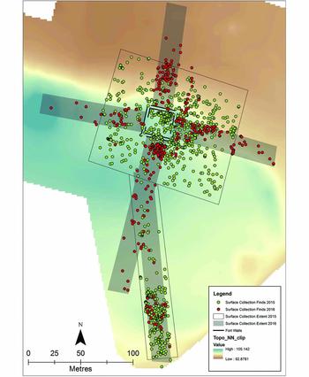
Excavation has revealed internal mud-brick walls, but the only internal structures visible on the surface were a few rough stone constructions against the inner face of the main wall. These were associated with seventeenth-century and later pottery. Pottery is scarce on the surface within the fort, but Sasanian-period imports are scattered outside (namely SMAG, LISV, TORP, TURQ (including type 64) and IRPW) (Figure 8). These become sparser as one moves away from the fort, with the exception of an area to the south associated with lime-burning kilns (Figure 9). The Sasanian-period pottery is mixed with a dense scatter of Iron Age wares from earlier occupation.
Selected diagnostic pottery associated with the occupation of the fort: a–c) TORP; d–e) SMAG; f–i) LISV; j) IRPW; k) SBBW; l) Indian black-painted; m–r) TURQ (turquoise); s) TURQ (yellow green, type 64). See Kennet (Reference Kennet2004) for a description of these classes and types.

Plan showing the concentration of Sasanian-period pottery recorded on the surface around the fort and the lime kilns to the south.

The fort's military nature is very obvious through the thickness of its walls, its size and layout, the scarcity of evidence of domestic activity and the lack of associated settlement. The fort was built principally to withstand attack; the corner towers and the narrow entrance flanked by buttress towers were designed to optimise security.
Excavation
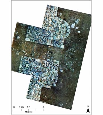
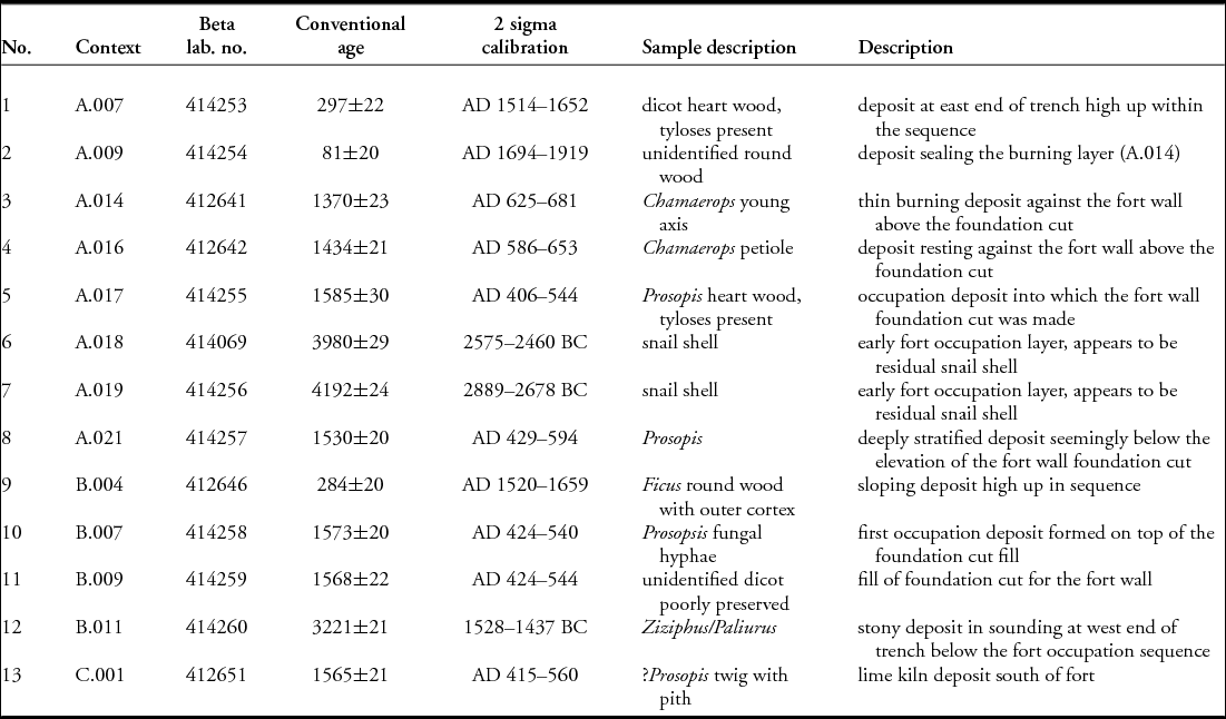
The excavations were intended to elucidate the fort's construction and layout, and the depth, nature and date of occupation. Excavation at the base of the walls demonstrates that they survive, below ground, up to 1.26m in height (Figures 7 & 10). Below the surface, traces of lime mortar were revealed between stones, thus linking to the lime kilns mentioned above. One of the kilns was excavated; the 14C evidence and pottery indicate that they were built and used during the fort construction (Table 1: 13).
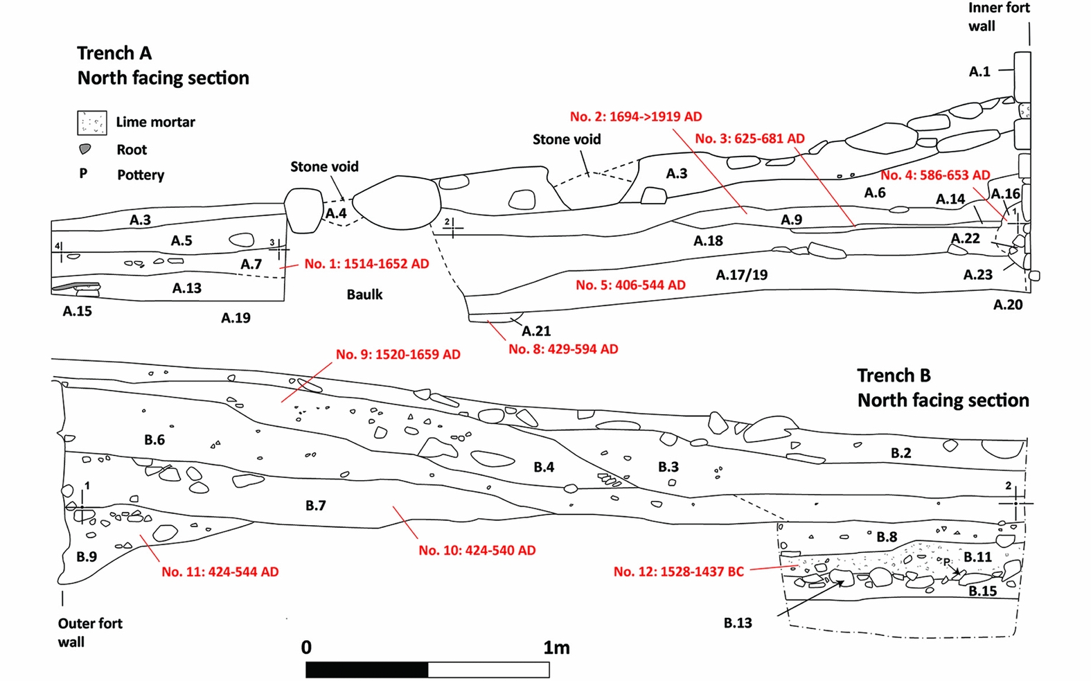
North-facing sections through trenches A and B on the interior and exterior of the western side of the fort. Red text indicates AMS sample locations and dates.

AMS dates from the fort.

Excavations within the fort in trenches A, B, F and G (Figure 4) all revealed a similar sequence. The fort walls were set within a shallow foundation cut, excavated into Iron Age deposits. The backfill contains Sasanian-period pottery (e.g. SMAG and SBBW in the trench G foundation cut fill (context G.016) (Figure 10)). In trenches A, B and G the foundation cut deposit is covered with a shallow occupation surface relating to use of the fort. In trench F, a 4m-long × 0.28m-wide mud-brick wall abutted the north wall, which is associated with a series of compacted clay floors. The wall appears to have been part of a second phase internal room built against the east wall inside the entranceway. Following the subsequent abandonment of the fort, large quantities of fine, largely sterile, sediment built up against the wall through natural processes and, possibly, the erosion of a mud-brick superstructure. Further excavation is required to determine the full internal layout.
Dating
The construction and main use of the fort is dated by AMS and pottery. Thirteen AMS dates were obtained from trenches A, B and C: from the pre-fort occupation; from the main wall foundation trench and initial occupation phase; from a camp fire associated with an early abandonment phase; and from the accumulation of sediment against the walls high in the sequence (Figure 10). Two of these (Table 1: 1 & 2) from the uppermost layers of trench A date to the sixteenth/seventeenth century AD or later, and relate to the late structures mentioned above. Five date to the early fifth to mid/late sixth centuries AD (Table 1: 5, 8, 10, 11, 13)—greater precision being limited by the calibration curve. They relate to the construction and main occupation phases, including the lime kiln in trench C. Two samples (Table 1: 3 & 4) come from layers overlying the main occupation phase and probably relate to abandonment or ephemeral later use; the later sample (3) comes from wind-blown sand and ash (Figure 10: A.014). This later occupation belongs to the mid seventh century—possibly starting in the later sixth century. Three further samples (Table 1: 6, 7, 12) relate to earlier occupation. At least two of these are residual (Bronze and Iron Age) and are therefore not relevant here.
The excavated ceramic assemblage is small: 2313 sherds were retrieved, most of which come from underlying Iron Age layers. Only 346 sherds are associated with the Sasanian-period or Early Islamic occupation (Figure 8). The closest assemblage comparisons are with Jazirat al-Ghanam and phases I–II at Kush (de Cardi Reference de Cardi1972: fig. 8; Kennet Reference Kennet2004: tab. 41). There are also parallels with Sir Bani Yas, area D at Jazirat al-Hulaylah, al-Qusur and Kush III, which are all dated to around the mid seventh to the mid/late eighth century (Patitucci & Uggeri Reference Patitucci and Uggeri1985; Sasaki & Sasaki Reference Sasaki and Sasaki1996: figs 46, 48–49; Kennet Reference Kennet2004: 13–18; Carter Reference Carter2008: figs 13–16). Elements of these later assemblages are, however, missing, including carinated glazed bowls, Honeycomb ware, jars with stamped rosettes and cream torpedo jars, suggesting that most of the Fulayj material is earlier (Kennet Reference Kennet2004: TURQ Type 72, HONEY; Priestman Reference Priestman2013: TORP.RG, STAMP).
Combined, this evidence sets out a robust chronology. It seems clear that the fort was constructed and first used during the fifth or sixth centuries AD. This was followed either by continuous occupation until the mid seventh century, or by a period of abandonment and a second period of use at that time. There is no evidence of subsequent use until the sixteenth century and later.
How does the fort compare with other Sasanian installations? It differs distinctly from forts on the Gorgan Wall, which, while also provided with projecting towers, are much larger, brick-built and with internal oblong barracks. Architecturally more similar is the Sasanian hinterland fort of Buraq Tappeh (approximately 70 × 80m), with a central courtyard and accommodation alongside the tower-reinforced walls (Nokandeh et al. Reference Nokandeh, Omrani Rekavandi and Sauer2016: 575). Closer parallels of similar size, with four corner towers and a projecting gate (with or without interval towers), are found on the Iranian Plateau and on the south-western approaches to Mesopotamia (Finster & Schmidt Reference Finster and Schmidt1977: 10–12, 44–54; Kleiss Reference Kleiss1993: 185–88; Mohammadifar & Amini Reference Mohammadifar and Amini2015–Reference Mohammadifar and Amini2016: 106–108; for a similar Late Sasanian monastery, see Amin Ali & Deroche Reference Amin Ali, Deroche, Kopanias and MacGinnis2016). Unlike the massive fortifications in the north, however, Fulayj-type forts were designed for policing internal territories or thinly populated desert frontiers.
Similar small forts with round/U-shaped corner towers were also built in Central Asia and across the Roman world from the late third century AD (Garbsch Reference Garbsch1970: 15, figs 22–23; Gregory Reference Gregory1997: vols 1, 2 & 3; Hedinger Reference Hedinger, Bridger and Gilles1998; Bondoc Reference Bondoc2009: 35–36, 231, 245, figs 3–4; Lenoir Reference Lenoir2011: 296–98, figs 34–41, 149; Grene & Rapen Reference Grene, Rapen, Lur'e and Torgoev2013: 24–25; Rizos Reference Rizos2015: 663, fig. 3). The Late Roman fort of Ain Labakha in Egypt is smaller, but its walls survive to 11.5m in height, thus providing an idea of how imposing Fulayj may have been (Reddé Reference Reddé1999: 380, 390–93). Fulayj follows a trend in defensive architecture from Western Europe to Central Asia, rather than a specifically Sasanian or Roman military tradition.
Discussion
It is worth considering why the fort was built at this location, being isolated and some distance from the fertile coastal plain and with no obvious links to occupation or activity in the vicinity. A number of points are worth making: U-shaped corner towers were introduced to Eastern Arabia at around the same time as the rest of the Roman/Sasanian worlds, the earliest examples being the forts at Ed-Dur (UAE) in area C, from the first/second century AD, and area F in the mid second to mid third centuries (Al-Qaysī Reference Al-Qaysī1975: 106–108; Potts Reference Potts1990: 275–76, 300; Lecomte Reference Lecomte and Finkbeiner1993; Mouton Reference Mouton2008: figs 55, 89–91, 106; Mouton & Schiettecatte Reference Mouton and Schiettecatte2014: 67–69). Although the Ed-Dur area C fort is a closer parallel, the proposed date requires verification. Dating of the larger fort at Qala'at al-Bahrain is also problematic, although a pre-Islamic date is most probable (Kervran Reference Kervran, Robin and Schiettecatte2013). By the Late Sasanian/Early Islamic period, such towers were certainly the norm in this region, as is demonstrated by building 5 at Jumairah in Dubai (UTM 40R 322780/2787890), and by the fort in the Early Islamic town of Siraf, which is thought to be Sasanian, but is possibly Early Islamic in date (Potts Reference Potts1990: 300; Priestman Reference Priestman2005).
The forts at Mleiha areas CW and H, and Ed-Dur area F, were in use until only very early in the Sasanian period (Benoist et al. Reference Benoist, Mouton and Schiettecatte2003; Kennet Reference Kennet2005: 113; Mouton et al. Reference Mouton, Tengberg, Bernard, Le Maguer, Reddy, Soulié, Le Grand and Goy2012; Mouton & Schiettecatte Reference Mouton and Schiettecatte2014: 59–62). With the possible exception of the small house-tower at Kush (Kennet Reference Kennet, Schiettecatte and Robin2009: 144–49), Fulayj is unique in that it is the only fort in Eastern Arabia dated to the Late Sasanian period (i.e. fifth to mid seventh centuries). Fulayj is different to the Ed-Dur and Mleiha forts in that it is isolated, rather than being associated with a settlement; military occupation is suggested by its very thick, solid-stone, lime-mortared walls and few associated finds. This contrasts with the earlier forts, all of which are located within settlements, have only varying degrees of defensive capability, and—in two cases at least—have a rich, luxury domestic artefact assemblage. Fulayj has the appearance of having been built and manned by a professional army, rather than being the fortified residence of a local potentate. Given the apparent lack of any political structure in ‘Uman at this time capable of such an undertaking, it seems highly probable that the fort was built by the Sasanians themselves. The unusual ceramic assemblage reinforces this idea. It is dominated by coarse grey tubular ‘vessels’ made from a probable local fabric, which are unusual in being open at both ends. They may have been used during construction of the fort. The only other Sasanian-period ceramics are imports originating from the Sasanian heartland of Iraq and Iran, with smaller quantities coming from South Asia. This suggests a degree of external provisioning and reinforces the idea of occupation by a foreign military force.
As already observed, historical sources such as Tabari indicate renewed Sasanian interest in Arabia during the reign of Khusraw I (AD 531–579), which may have included some military construction (Potts Reference Potts1990: 335–38, Reference Potts2008; Bosworth Reference Bosworth1999: 290–92). Some scholars have suggested that a military force might have been placed in ‘Uman at this time, although the evidence for this is weak (e.g. Potts Reference Potts2008: 210–11; Munt Reference Munt2017: 269). The empire-wide reorganisation of Sasanian defences from the fifth century to Khusraw I, however, provides a possible context for the construction of Fulayj.
What was the rationale behind the construction of a fort in this location? Aside from the presence of copper in the local foothills (typical of the area), it is not situated close to any route, settlement or resource. It is difficult to imagine that it had much military value in isolation. Conversely, it would make sense had it been part of a chain of forts separating the coastal plain, which has long been the main focus of agriculture and occupation (Kennet et al Reference Kennet, Deadman and al-Jahwari2016: 155). Parallels do exist: a chain of probable Sasanian forts guarded the approaches to the Khandaq Shapur Canal and the Euphrates (Finster & Schmidt Reference Finster and Schmidt1977; Lawrence & Wilkinson Reference Lawrence, Wilkinson and Sauer2017: 105–106), a military control line similar to the fort-lined Gorgan, Tammisheh, Darband and Ghilghilchay walls. Sasanian fortifications along the key route into TransCaucasia may have offered safe shelter for military forces or officials (Lawrence & Wilkinson Reference Lawrence, Wilkinson and Sauer2017: 105–106, 114–16; Sauer et al. Reference Sauer, Nokandeh, Pitskhelauri, Omrani Rekavandi and Sauer2017: 257–58). Some of these are a day's march apart, as are examples in Fars (Ghasemi Reference Ghasemi2012). A chain of forts guarding access to fertile land or strategic supply routes was a common concept across the Roman and Sasanian worlds. The Fulayj fort may similarly have been a staging post on an inland route, intended to protect the approaches to the coastal plain and perhaps a port. A larger, probably Sasanian fort with projecting corner and interval towers, at Ratto Kot near the Indus mouth (Kervran Reference Kervran, Curiel and Gyselen1994: 337–39), perhaps also secured access to the interior and the empire's strategic and commercial interests across the Indian Ocean.
While these ideas remain to be confirmed through remote sensing and fieldwork, further evidence supports this interpretation. Firstly, the putative treaty between the Arabs of the interior and the Persians occupying the coastal areas is reported in the Ansāb al-‘Arab, dated to the late tenth century. It was discussed by J.C. Wilkinson (Reference Wilkinson1973) and has since formed the basis of our understanding of late pre-Islamic Oman:
There was a peace treaty (muhādana) between them [the Persians] and the family of al-Julandā in Oman, in which [it was stipulated] that there would be 4,000 asāwira and marāziba together with a tax collector for them there nearby the kings of the Azd. The Persians would stick to the coastal plain (al-sawāḥil wa-shuṭūṭ al-baḥr) and the Azd would be kings in the mountains, the desert and other such places on the fringes of Oman. All affairs were to be in their charge (al-Awtabi 2006: 762; Munt Reference Munt2017: 279).
It is impossible to know how reliable this information might be, particularly given that it was written around 350 years after the events described. Munt (Reference Munt2017) emphasises that the date of the treaty is uncertain, and may refer to a later period. Nonetheless, such an arrangement may have necessitated a defensive line along the back of the plain and the environs of Sohar.
A second piece of evidence is the presence of Sasanian-period finds in isolated cairn burials in the interior. Examples are the burial with Sasanian seals from al-Madam, the possible Sasanian pottery from cairns in the Wadi Jizzi, Jabal Emailah and Jabal Buhias, and Shimal in Ras al-Khaimah (Vogt & Franke-Vogt Reference Vogt and Franke-Vogt1987: 45–48, fig. 30; Potts Reference Potts1997; Benton & Potts Reference Benton and Potts2010; Jasim Reference Jasim2012: 263; Düring & Olijdam Reference Düring and Olijdam2015: 102–103; Kutterer et al. Reference Kutterer, Jasim and Yousif2015). Other unpublished examples have recently been revealed 15km inland from the coast at Liwa, north of Sohar, and the Wadi al-Arad, where as many as 50 tombs are located (S. Laurenza pers. comm.). It seems certain that others will be found. The precise date of these tombs is still unclear: one at Liwa contains a coin of Hormizd II (AD 303–309), while one from al-Madam is dated to the fifth/sixth century. The armour from another tomb, near al-Madam, has been dated to the Late Sasanian period (Potts Reference Potts1997; Kutterer et al. Reference Kutterer, Jasim and Yousif2015: 46). The lack of related settlements suggests that these tombs are all that remains of nomadic Arab tribes who occupied the interior during the Sasanian period. It was the management of the relationship with these groups that was perhaps the rationale behind the construction of Fulayj.
This pivotal period in the late pre-Islamic history of ‘Uman is difficult for historians and archaeologists in that the paucity and problematic nature of the evidence make it impossible to draw firm conclusions. In this context, the discovery of a Late Sasanian fort provides important new evidence. It is the first such structure discovered, and provides insights into the way that Sasanian control was exercised, and into the political-economic geography of ‘Uman in the period preceding Islamisation. The AMS dates from the site strengthen confidence in the regional ceramic chronology.
If the interpretation presented here is correct—namely that Fulayj is the product of the Sasanian military—then it is evidence that even in Eastern Arabia, a region that seems otherwise to have bucked the broader trend of Late Sasanian economic growth and cultural/political integration (e.g. Payne Reference Payne2014), there is evidence of strategic investment in territorial control. When set alongside frontier defences elsewhere in the Empire, including northern Iran, the Caspian, the Caucasus and the margins of Iraq, Fulayj provides a further, important contribution to our understanding of the scale and reach of the Sasanian state and its growing power and organisational capabilities (e.g. Howard-Johnston Reference Howard-Johnston2014: 148).
Acknowledgements
Thanks are due to the Ministry of Heritage and Culture of the Sultanate of Oman, especially to His Highness Sayyid Haitham bin Tariq Al Said, His Excellency Salim bin Mohammed Al Mahruqi and His Excellency Hassan Mohammed Ali Al-Lawati. We are grateful to Sultan Saif Nasser Al-Bakri, General Director of Archaeology, and to his staff. Funding was made available by the European Research Council project ‘Persia and its Neighbours’. Thanks are due to Sabatino Laurenza for providing unpublished information from his recent excavations. Thanks also go to Richard Payne and Jérémie Schiettecatte, whose comments added greatly to the quality of the paper.