The rise and fall of ancient polities are most often attributed to the actions of the political elite, while the day-to-day activities of ordinary commoners fade into the background and are thought to have been merely affected by broader events. Yet the actions and choices made by the nonelite can condition, change, and actively construct the structures that situate their everyday lives (Pauketat Reference Pauketat, Dobres and Robb2000; Robin Reference Robin2003, Reference Robin2013). For example, in his influential article, “Tragedy of the Commoners,” Pauketat (Reference Pauketat, Dobres and Robb2000) argued that through the unintended consequences of the actions of commoners conditions were created that enabled the centralization of authority in the prehistoric southeastern United States. Household archaeology has similarly sought to document the ways in which the everyday lives of ordinary people articulate with broader political and economic change. Hendon (Reference Hendon, Meskell and Preucel2004:272), cautions that we should avoid thinking of the household as “an analytical unit representative of some set of behaviors…and instead see households as the result of the interaction of structure and agency, larger social forms, and the individual.” She argues for a social approach to household archaeology that integrates a focus on the meanings of daily practice (rather than simply their functions), with a recognition of household variability and settings, and an understanding of social interactions and processes (Hendon Reference Hendon, Meskell and Preucel2004). In this article, we take a social approach to household archaeology that considers the recursive interaction between households and broader political economies and the ways in which ordinary people influence the path of history.
Household archaeology conducted at the site of Xaltocan in the northern Basin of Mexico illustrates how the everyday actions of ordinary people can contribute to the rise and decline of ancient polities. Founded by a.d. 900, Xaltocan quickly rose to become an important and powerful pre-Aztec city-state in the northern Basin. Xaltocan's supremacy, however, was rather short lived and, like many other polities in central Mexico, it was ultimately incorporated into the Aztec empire. Although when viewed in retrospect the supremacy of the Aztec empire may seem inevitable, Morehart (Reference Morehart2012) recently argued that any number of circumstances could have resulted in a different outcome, including one where Xaltocan could have become the dominant power within the Basin of Mexico. Thus, in this article we ask, what factors contributed to the rise and fall of Xaltocan? The numerous historical chronicles that document central Mexican history focus on the alliances, conquests, and genealogies of the political elite, constructing a “public transcript” (Scott Reference Scott1990) that masks the daily actions of ordinary commoners. We argue, however, that in order to comprehend the rise and fall of ancient polities such as Xaltocan, we need to instead reconstruct a narrative that integrates the infrapolitics (Scott Reference Scott1990), the strategies and actions of those not documented in historical accounts, into our understandings of the past.
Through a study of long-term change and variation from multiple household contexts throughout Xaltocan, this article reconstructs how the economic and political activities of ordinary households were central to the construction and reproduction of political institutions, social structures, and regional systems of exchange within central Mexico. First, we examine household organization and strategies in the period of Xaltocan's growth into a regional power and argue that Xaltocan's rise to power may have been largely instigated by the economic and political activities of ordinary households. We then examine continuity and change in commoner daily practice as Xaltocan's power waned and consider how households contributed to, and were affected by, Xaltocan's decline in supremacy. We demonstrate that households were variable and dynamic—they each employed their own unique economic strategies and made different decisions when faced with similar challenges. The decisions made by individual households were likely related to immediate concerns affecting the household (Wilk Reference Wilk1997:30), but had intended and unintended consequences at the macro-scale. Household archaeology at Xaltocan thus ultimately reveals that change is created by the actions of ordinary people acting in everyday contexts.
XALTOCAN: AN ISLAND CAPITAL
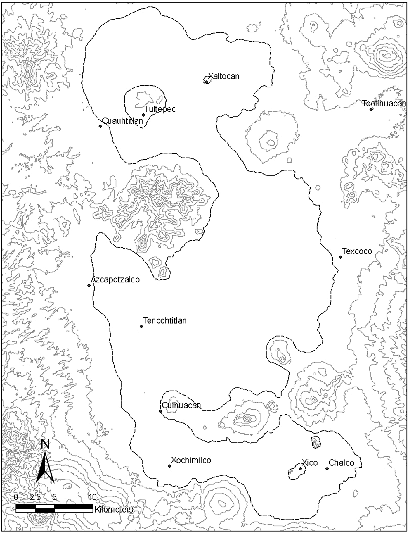
Xaltocan was an island community located in the middle of Lake Xaltocan in the northern Basin of Mexico (Figure 1). The site was an artificially constructed island, rising approximately 6 m above the lakebed, and was founded at the beginning of the Early Postclassic period (a.d. 900–1150) (Brumfiel Reference Brumfiel2005b:35). According to historic accounts, by a.d. 1220, Xaltocan had become the capital of the Otomi nation, controlling much of the northern basin and collecting tribute from surrounding villages (Alva Ixtlilxóchitl Reference Alva Ixtlilxóchitl1975–1977:1:423; Carrasco Pizana Reference Carrasco Pizana1950:258–259; Gibson Reference Gibson1964:440). Pedro Carrasco Pizana (Reference Carrasco Pizana1950:116) suggests that during the Middle Postclassic period (a.d. 1150–1350), the Valley of Mexico was dominated by Xaltocan, Culhuacan, and Tenayuca. By the mid-thirteenth century, Xaltocan had become embroiled in a war with Cuauhtitlan, and by a.d. 1395 it was conquered by the Tepanecs (Bierhorst Reference Bierhorst and Bierhorst1992:75). Historic accounts state that upon its conquest the Otomi people fled Xaltocan (Alva Ixtlilxóchitl Reference Alva Ixtlilxóchitl1975–1977:2:36) and the city remained uninhabited until a.d. 1435 when it was incorporated into the Aztec empire and was resettled by tribute paying Aztec peasants (Hicks Reference Hicks, Marcus and Zeitlin1994b). DNA analysis of burials from before and after the Aztec period indicates that there was a demographic shift following Xaltocan's incorporation into the Aztec empire (Mata-Míguez et al. Reference Mata-Míguez, Overholtzer, Rodríguez-Alegría, Kemp and Bolnick2012); however, it is unclear whether there was complete abandonment of the site by its original inhabitants, or if it only affected a segment of the population, such as elites (Hicks Reference Hicks, Marcus and Zeitlin1994b; Miller Reference Miller2007:28; Morehart Reference Morehart2012). Archaeological evidence suggests that there may have been some occupational continuity throughout this supposed period of abandonment (Miller Reference Miller2007; Overholtzer Reference Overholtzer2013). In 1521, Xaltocan was conquered once again by Cortés (Alva Ixtlilxóchitl Reference Alva Ixtlilxóchitl1975–1977:2:247; Díaz del Castillo Reference Díaz del Castillo1996 [1575]:357), and during the Colonial period the Spanish consolidated people from nearby towns into the settlement (Rodríguez-Alegría Reference Rodríguez-Alegría2010).
Basin of Mexico showing location of Xaltocan and other important sites. Map by Kristin De Lucia.

Archaeological phases at Xaltocan are based on stylistic transitions in Black-on-Orange pottery (Figure 2). The Aztec I phase (a.d. 900–1250) is characterized by the production and consumption of Aztec I Black-on-Orange decorated pottery and strong economic ties with the southern Basin of Mexico (Brumfiel Reference Brumfiel and Quiñones Keber2000, Reference Brumfiel and Brumfiel2005a; Hodge and Neff Reference Hodge, Neff and Brumfiel2005). Recent excavations of Aztec I houses by De Lucia (Reference De Lucia2011) suggest that the exclusive use of Aztec I pottery extended from a.d. 900 through approximately a.d. 1250 in Xaltocan, coinciding with the Early to Middle Postclassic periods. The use of Aztec I pottery is associated with Xaltocan's initial settlement, the initiation of raised field or chinampa agriculture (Morehart and Eisenberg Reference Morehart and Eisenberg2010; Morehart and Frederick Reference Morehart and Frederick2014), and its growth into the capital of the Otomi nation. The Aztec II phase (a.d. 1250–1350) is characterized by the introduction of Aztec II Black-on-Orange pottery and increased consumption of redwares, and overlaps with the Middle Postlcassic period. The Aztec II phase is associated with Xaltocan's political dominance, but also conflict and warfare with neighboring Cuauhtitlan. At this time, there was an expansion of the settlement size (Chimonas Reference Chimonas and Brumfiel2005) and chinampa agriculture (Morehart and Eisenberg Reference Morehart and Eisenberg2010; Morehart and Frederick Reference Morehart and Frederick2014). Exchange with the southern basin, however, declined while exchange with the middle Basin of Mexico increased (Brumfiel Reference Brumfiel and Brumfiel2005a; Hodge and Neff Reference Hodge, Neff and Brumfiel2005). The Aztec III phase (a.d. 1350–1521) coincides with the Late Postclassic period and is characterized by the use of Aztec III Black-on-Orange pottery (Brumfiel Reference Brumfiel and Brumfiel2005a; Overholtzer Reference Overholtzer2012). During this phase Xaltocan was conquered, abandoned, and subsequently incorporated into the Aztec empire. This phase is characterized by a decline in population and overall standard of living (Brumfiel Reference Brumfiel2005b; Chimonas Reference Chimonas and Brumfiel2005) and an abandonment of chinampa farming (Morehart and Eisenberg Reference Morehart and Eisenberg2010; Morehart and Frederick Reference Morehart and Frederick2014). Finally, the Aztec IV phase (a.d. 1521) is associated with Aztec IV Black-on-Orange pottery and is associated with the Colonial period (Overholtzer Reference Overholtzer2012, Reference Overholtzer2014; Rodríguez-Alegría Reference Rodríguez-Alegría2010). The phases outlined here are slightly modified from the phases originally proposed by Brumfiel (Reference Brumfiel and Brumfiel2005a) due to recent findings discussed below and elsewhere (De Lucia Reference De Lucia2011; Overholtzer Reference Overholtzer2012, Reference Overholtzer2014). Overholtzer (Reference Overholtzer2014) used Bayesian statistical modeling of a corpus of 54 radiocarbon dates to further define this chronology.
Black-on-Orange pottery styles from Xaltocan: (a) Aztec I, (b) Aztec II, (c) Aztec III, (d) Aztec IV. Photos courtesy of Kristin De Lucia (a-b) and Lisa Overholtzer (c-d).
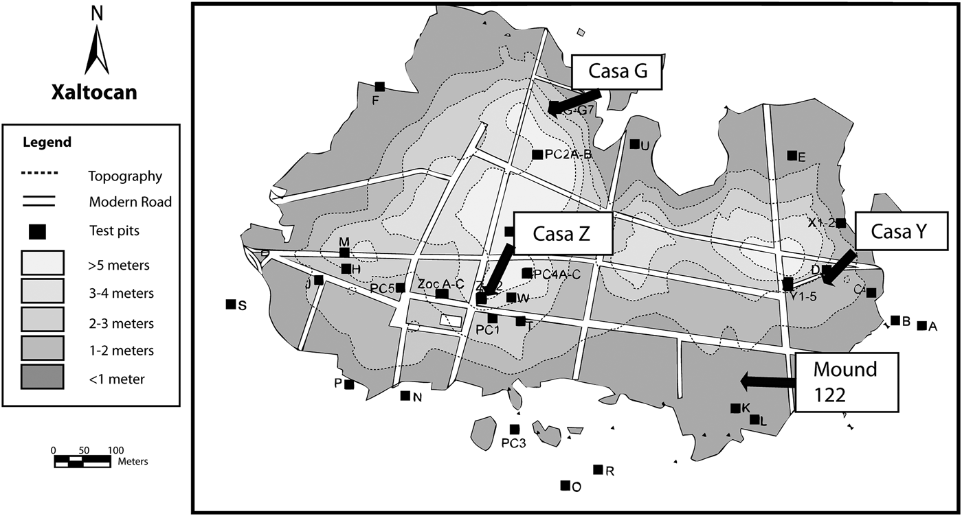
Elizabeth Brumfiel conducted over 25 years of research on domestic units at Xaltocan, including an intensive survey of the site, the excavation of 25 test pits, horizontal excavations of several Aztec I houses, and the excavation of a group of Aztec II burials (Brumfiel Reference Brumfiel2005b, Reference Brumfiel2010; Brumfiel and Rodríguez-Alegría Reference Brumfiel and Rodríguez-Alegría2010; De Lucia and Brumfiel Reference De Lucia and Brumfiel2004) (Figure 3). Brumfiel's students and colleagues built upon her work at Xaltocan, investigating pre-Aztec household economic and social strategies (De Lucia Reference De Lucia2010a, Reference De Lucia2011, Reference De Lucia2013, Reference De Lucia2014), agricultural strategies (Morehart Reference Morehart2014, Reference Morehart2010; Morehart and Eisenberg Reference Morehart and Eisenberg2010; Morehart and Frederick Reference Morehart and Frederick2014), household practices under imperial and colonial rule (Millhauser et al. Reference Millhauser, Rodríguez-Alegría and Glascock2011; Overholtzer Reference Overholtzer2012, Reference Overholtzer2013), and the aftermath of Spanish Conquest (Brumfiel and Rodríguez-Alegría Reference Brumfiel and Rodríguez-Alegría2010; Rodríguez-Alegría Reference Rodríguez-Alegría2008, Reference Rodríguez-Alegría2010, Reference Rodríguez-Alegría, Oland, Hart and Frink2012; Rodríguez-Alegría et al. Reference Rodríguez-Alegría, Millhauser and Stoner2013). This paper seeks to synthesize the household research conducted at Xaltocan to date in order to provide a multiscalar narrative of the relationship between households and broader regional transitions in the northern Basin of Mexico, focusing on household practices during Xaltocan's rise and fall as a prominent independent polity. To date, our understanding of political and economic change in pre-Aztec Xaltocan has largely derived from a public transcript presented in historic accounts recorded during the colonial period, but household archaeology at Xaltocan offers new insight into the ways in which households and ordinary people shaped history.
Topographic map of Xaltocan showing locations of excavations discussed in text (adapted from Miller Reference Miller2007).
XALTOCAN'S RISE TO POWER: AZTEC I HOUSES
The Aztec I Phase corresponds with Xaltocan's founding and rise to power and spans the period from a.d. 900–1250. Five Aztec I houses have been excavated across Xaltocan including Casa G, Casa Y, Casa Z Structure 1, Casa Z Structure 2, and Casa Zoc (Figure 3). The following discussion focuses primarily on Casa G and Casa Z Structure 1, which have been most extensively excavated and studied to date; however, we describe all of the excavations of Aztec I domestic units below, with the exception of Casa Zoc, which is still under analysis (Brumfiel and Rodríguez-Alegría Reference Brumfiel and Rodríguez-Alegría2010). While Aztec I Black-on-Orange pottery is the most common pottery type associated with this phase, other frequent types include imported Chalco-Cholula polychromes and locally produced and imported redwares (Brumfiel Reference Brumfiel and Brumfiel2005a; De Lucia Reference De Lucia2011; Nichols et al. Reference Nichols, Brumfiel, Neff, Hodge, Charlton and Glascock2002).
Casa G
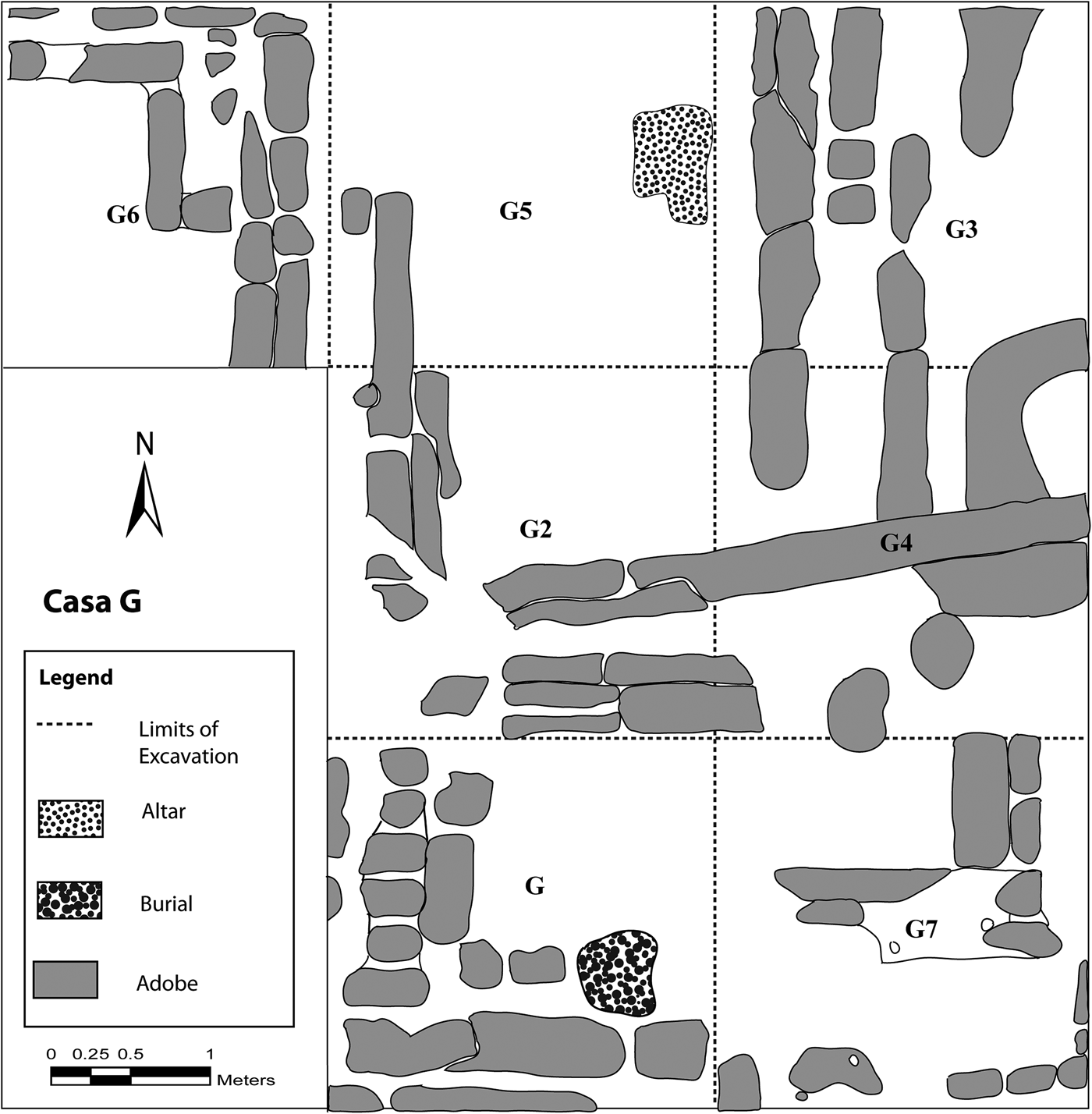
The first Aztec I house excavated by Brumfiel (Reference Brumfiel2010) was Casa G, located on a small mound (Mound 79) on the north edge of the site. Seven 2 × 2 m-units were excavated over a period of several years, exposing at least three rooms of the house and an outdoor patio (Figure 4). The walls of Casa G were roughly oriented according to the cardinal directions and were composed of sandy adobe blocks (Brumfiel Reference Brumfiel2010). Floors were constructed of clay blocks, dirt, and adobe flagstones. In the uppermost level of Casa G, excavators encountered impressions of reed bundles and slabs of wood used in roofing. The house continued in all directions beyond the limits of excavation, so its full extent remains uncertain, but the presence of multiple hearths in single levels suggests that it was occupied by multiple households at the same time. At least three phases of construction were identified in Casa G by Brumfiel (Reference Brumfiel2010), and sequences of at least 12 stratified floors identified in excavation profiles suggest that Casa G was continuously occupied for a long period of time. A radiocarbon date taken from a corn cob inside one room hearth provided a 2-sigma calibrated date range of a.d. 790–1170.
Plan map of Casa G, during the final phase of occupation. Squares represent the seven 2 × 2 m units of excavation. Map by Santiago Juarez.
The Aztec I house rested upon a thick black clay foundation that lacked artifacts. This clay foundation was an intentional construction that prevented moisture from the lakebed from seeping into the structure and created a stable surface (Brumfiel Reference Brumfiel2010). Under the clay foundation was over a meter of lakebed and cultural fill that included Aztec I Black-on-Orange pottery, domestic refuse, and decayed organic materials. A radiocarbon sample taken from the construction fill provided a 2-sigma calibrated date range of a.d. 800–985, suggesting that this mound was built at the end of the Epiclassic period (a.d. 650–900) or early in the Early Postclassic period, possibly using fill redeposited from an earlier occupation, and likely represents the first settlement of Xaltocan. Nearby lakebed shrine sites associated with Late Classic and Epiclassic pottery investigated by Brumfiel (Reference Brumfiel2010) and Morehart et al. (Reference Morehart, Peñaloza, Sánchez, de Tapia and Emilio2012) suggest that people had been visiting the region surrounding Xaltocan for ritual purposes since well before the site was settled.
High frequencies of projectile points and rabbit bone identified in Casa G reflect relatively intense hunting of wild game. These frequencies are higher than in the other Aztec I houses, and Brumfiel (Reference Brumfiel2010) suggested that the inhabitants of Casa G were involved in hunting for exchange with other households. In addition, there was evidence for the manufacture of tools for household-level consumption including obsidian blades, cloth, and salt. It is likely that the occupants manufactured their own tools given the high frequency of small obsidian flakes recovered from fill. Activity areas were not identified, but ground stone tools clustered in the outdoor patio suggest that this may have been a space for household food production.
Features associated with different types of ritual activities were identified in Casa G. Three infants, all in seated positions, were buried under floors in small pits located near adobe walls. None of the infants were directly associated with any grave goods. In addition, in the patio area there was a hardened clay block coated with painted plaster that was interpreted by Brumfiel as an altar. Excavations also uncovered a cache of artifacts that included fifteen slingshot pellets, five projectile points, a chert biface, two floor polishers, a chunk of groundstone, a bone needle, two bone spatulas, a ceramic pendant, a jasper borer, an onyx core, several obsidian blades, a figurine head, and two pieces of marine shell. This cache may have been a ritual deposit or a storage pit given the utilitarian function of many of the artifacts. In addition to ritual features, figurines and specialized ceramics were used in ritual activities. In Xaltocan, censers, braziers, and effigy vessels were associated with incense burning and are recovered from Early Postclassic domestic contexts across the site (De Lucia Reference De Lucia2014). These artifacts have been described in detail elsewhere and will not be further elaborated upon here (Brumfiel and Overholtzer Reference Brumfiel, Overholtzer, Halperin, Faust, Taube and Giguet2009; De Lucia Reference De Lucia2014; Overholtzer and Stoner Reference Overholtzer and Stoner2011).
Casa Z Structure 1
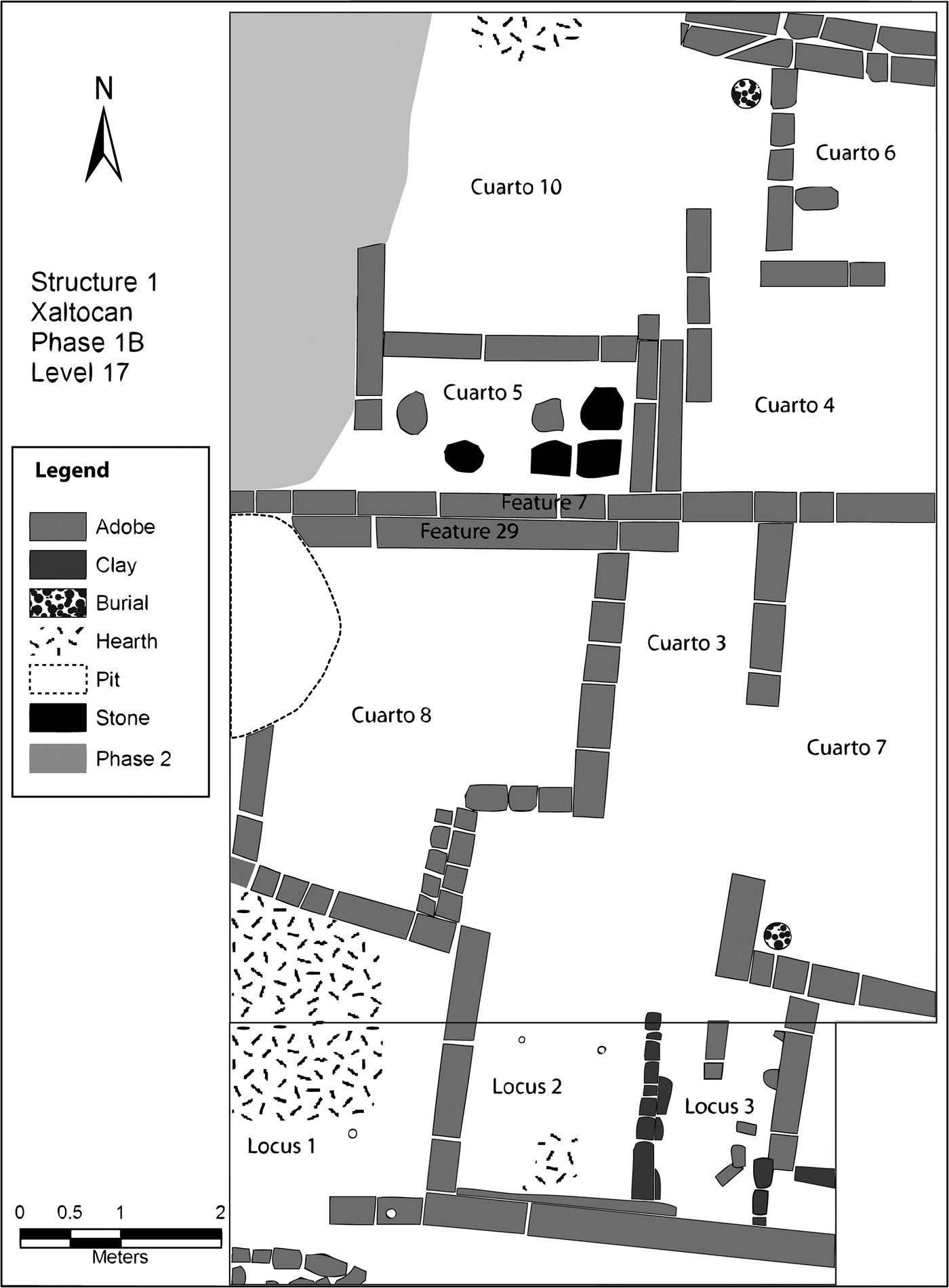
Casa Z Structure 1 was an Aztec I house investigated by De Lucia using broad horizontal excavations to expose a large portion of the structure (Figure 5). Structure 1 was located on a large mound (Mound 129) near the center of modern-day Xaltocan across from the town's sixteenth-century church. Structure 1 is the only household study in Xaltocan to employ microanalyses, including the analysis of microartifacts and inductively coupled plasma atomic emission spectroscopy (ICP-AES) analyses of anthropogenic soils from earthen floors, in order to understand the organization of space and diversity of production activities (De Lucia Reference De Lucia2011, Reference De Lucia2013). Microartifacts are tiny remnants of artifacts (such as bits of bone, ceramics, or lithics) that result from everyday human activities. Because microartifacts become embedded in floors as a consequence of trampling, they are not swept away or moved like macro-remains and therefore provide important insight into the organization of activity areas. As at Casa G, Structure 1 extended beyond the limits of investigation and, thus, the full extent of the structure is unknown. Excavations determined, however, that there were at least two separate households: one occupying the northern half of the building and another occupying the southern half, with each household utilizing multiple rooms and having separate hearths and middens.
Plan map of Casa Z Structure 1, Level 17 (160–170 cm). Map by Kristin De Lucia.
Structure 1's walls were roughly aligned with the cardinal directions and were made of adobe blocks with clay foundations, similar to those at Casa G. Within Structure 1 there were at least six phases of occupation represented by six levels of stratified earthen floors. Within these phases many of the same walls were reused through time, although there were some modifications as some walls were torn down and others constructed through time. In addition, there was one major renovation when most of the adobe walls were reconstructed with a new style of adobe block. Radiocarbon dates from Aztec I deposits of Structure 1 place occupation in the mid-eleventh through mid-thirteenth centuries a.d., with 2-sigma calibrated ranges from as early as a.d. 1000–1170 to as late as a.d. 1220–1290 (De Lucia Reference De Lucia2011:Table 1.2).
The inhabitants of Structure 1 engaged in multiple and diverse production activities. A comparison of activities between the two households occupying Structure 1 reveal that each specialized in the production of different types of goods and that each household produced multiple goods (De Lucia Reference De Lucia2011, Reference De Lucia2013). Production activities included fish processing, mat-making, bone working, utilitarian pottery production, and obsidian blade production. In addition, household members engaged in farming, maguey fiber processing, weaving, and pulque production for household consumption (De Lucia Reference De Lucia2011, Reference De Lucia2013; De Lucia and Morehart Reference De Lucia, Morehart, Morehart and De Lucia2015). In contrast to Casa G, low frequencies of projectile points in Structure 1 compared to the other Aztec I houses (Brumfiel Reference Brumfiel2010), combined with intensive consumption of meats, suggest that the inhabitants of Structure 1 obtained meat through exchange rather than hunting.
Each household occupied multiple rooms organized by function. For example, in the southern household there were separate rooms for production activities, sleeping, and entertaining guests. Chemical and microartifact analyses from Structure 1 indicate that all rooms with adobe flagstones were not used for production activities and have been interpreted by De Lucia (Reference De Lucia2011, Reference De Lucia2013) as “reception areas” or social spaces. Analysis of microartifacts also indicates that a large outdoor courtyard was used for both production and ritual activities. Excavations of the patio floor recovered micro-artifacts associated with everyday activities involving ceramic and lithic objects, but also unusual microartifact types such as turtle carapace, mica, and pigments. The patio also had a central square-cut stone that was likely an altar (De Lucia Reference De Lucia2014). To summarize, the organization of space suggests that high-intensity activities were restricted to particular rooms of the house and were segregated from family and social space. The outdoor patio is the only space that appears to have been multipurpose, with evidence for both household production and ritual activities.
In Structure 1, infants and children were buried under house floors. The remains of eight subadults, all less than three years of age, were recovered from Structure 1, five of which were interred directly into the structure walls (De Lucia Reference De Lucia2010a, Reference De Lucia2014). All of the burials from Structure 1 were located along the southern walls or in the southwest corners of rooms and only children older than one year of age were associated with grave goods (De Lucia Reference De Lucia2010a, Reference De Lucia2011). In addition to the burial of children, ritual activities included the use of incense and figurines for daily household ritual, the sacrificial burials of puppies, and the burial of offerings into walls and under floors (De Lucia Reference De Lucia2014). Fragments of incense burners and figurines were distributed throughout the structure and were not restricted to the patio or altar.
Casa Z Structure 2
Casa Z Structure 2 was partially excavated over two seasons by Brumfiel (Brumfiel Reference Brumfiel2010; De Lucia and Brumfiel Reference De Lucia and Brumfiel2004) and was located approximately 3 m to the south of Structure 1 on Mound 129. The structure was constructed after Structure 1 in Aztec I times. The house rested on a thick clay foundation, as seen in Casa G. Part of this clay foundation to the east appears to have been an outdoor workspace as suggested by the presence of flat lying artifacts on the surface. Under the clay foundation were layers of sand and clay mixed with Aztec I pottery and organic refuse. These deposits were likely shallow lakebed fill, representing the accumulation of layers of natural silts, sand, and clay mixed with trash probably associated with the early occupation of Structure 1. The presence of a few features within this area, including a hearth and a small adobe platform, suggests that this area was periodically exposed during the dry seasons and used as an activity area possibly by the inhabitants of Structure 1. These features also suggest that the accumulation of refuse in this area was a gradual process and did not occur in a single construction event. Two carbon samples taken from the trash deposits under Structure 2 provided 2-sigma calibrated dates of a.d. 1010–1180 and a.d. 990–1270, which correspond to the early phases of occupation of Structure 1, supporting the interpretation that these deposits represent the trash associated with the earliest occupation of Structure 1.
Only a single room of Structure 2 was exposed through excavation (Figure 6a), as well as part of an outdoor workspace, although it is likely that the structure extended beyond the limits of excavation to the south and west. Adobe walls were oriented to the cardinal directions as in the other houses. Three superimposed plaster floors were encountered in Structure 2, one associated with Aztec I ceramics and two associated with Aztec II ceramics, in addition to an earthen floor associated with Aztec I pottery. All of the floors were associated with adobe brick walls (Figure 6b).
(a) Plaster floor from Casa Z Structure 2, and (b) adobe wall of Casa Z Structure 2 showing multiple stratified floors spanning the Aztec I to Aztec II periods (adapted from De Lucia and Brumfiel Reference De Lucia and Brumfiel2004).
Because of the limited extent of excavations in Structure 2, the only clear evidence for intensive production came from a pit outside the house with a high density of obsidian (5.41 pieces per 100 rim sherds compared to an average of 1.29/100 sherds in Structure 1). The obsidian deposit was composed of debitage and mostly unused obsidian, with only 16% displaying evidence of use wear (compared to upwards of 96% in activity areas), indicating that this was production debris rather than an activity area or midden. This deposit was likely associated with Structure 1 given that it was dumped prior to the construction of Structure 2. Weaving tools and groundstone implements were only recovered from the outdoor area and not from the interior space, suggesting that these activities took place outside. As in the other houses, Structure 2 had evidence for spinning, salt making, hunting, and food processing for household consumption. No burials were recovered from the Structure 2 excavations, which is not surprising since most of the excavated area was outdoor space and lakebed fill, and burials typically occur within houses during the Aztec I period.
Casa Y
Casa Y was located on a mound on the eastern edge of Xaltocan (Mound 54) (Brumfiel Reference Brumfiel2010; De Lucia and Brumfiel Reference De Lucia and Brumfiel2004). A large trench was bulldozed through Mound 54 in the late 1980s to build a grain silo. The silo was never constructed, but the abandoned trench profile revealed that the mound was constructed of 60 cm of clay and sandy fill upon which a 50 cm high clay platform was constructed. Occupational debris associated with an Aztec I house (Casa Y) rested upon this platform. A radiocarbon sample taken from Casa Y provided a 2-sigma range with a bimodal distribution of a.d. 1060–1080 (p = .07) and a.d. 1150–1290 (p = .86).
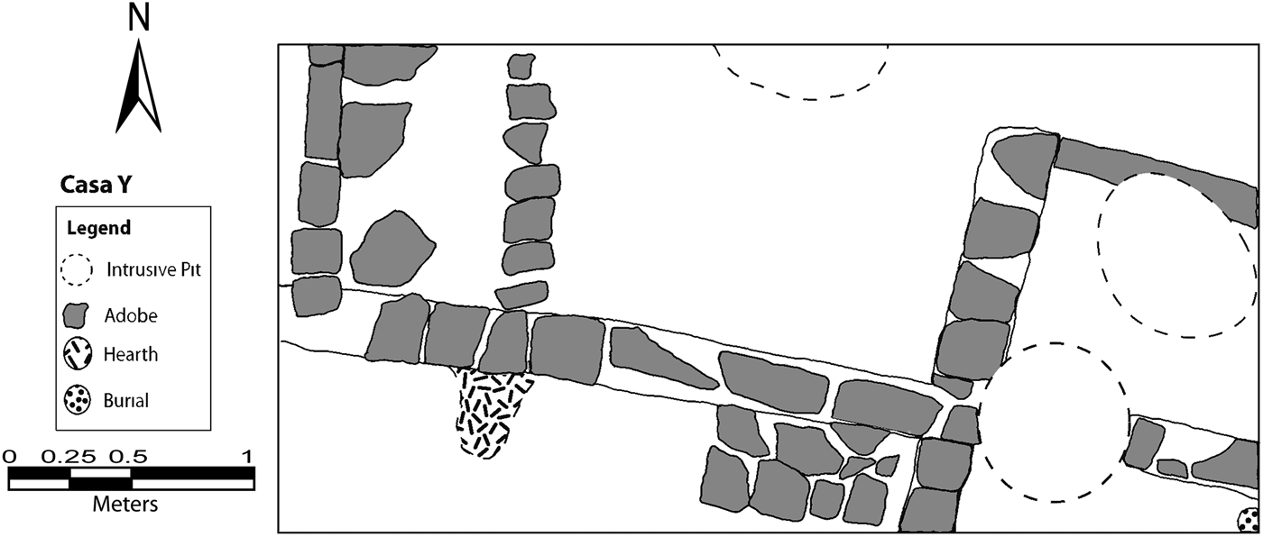
The excavations of Casa Y revealed four rooms and an outdoor patio (Figure 7). The adobe walls were oriented roughly according to the cardinal directions with a central wall running east-west across the unit, slanting slightly to the southeast. Floors of dirt and black clay and adobe cobbles were encountered. One infant burial was found under a house floor, partially dug into the wall in the southeast corner of the house. Finally, a large irregular-shaped burned area high in organic content (especially corn cobs) lay on top of the structure. This burned area yielded an unusually high frequency of ceramic balls and ritual vessels, including censer and brazier fragments. The combination of burned organic matter and ritual vessels suggest that the structure was either ritually burned upon abandonment or that people returned to the structure to perform ritual activities soon after it was abandoned.
Plan map of part of Casa Y as uncovered in a single 2 × 4 m excavation. Map by Santiago Juarez.
Casa Y residents engaged in the intensive exploitation of waterfowl, with significantly more waterfowl remains recovered than in any of the other houses excavated (Brumfiel Reference Brumfiel2010). Despite this evidence for waterfowl exploitation, there was little evidence for the use or production of projectile points or obsidian tool production. This is consistent with historic and ethnographic studies, however, which suggest that waterfowl were hunted primarily using nets and traps (Parsons Reference Parsons2006:80; Rojas Rabiela Reference Rojas Rabiela, Rabiela and Espinoza1985:72; Sugiura Yamamoto Reference Sugiura Yamamoto1998:114). The location of Casa Y, at the edge of the island looking out over the lake, would have facilitated the hunting of waterfowl using nets on posts and traps, which could have been observed from the house. In addition to waterfowl hunting, low intensity salt production, spinning, and bone tool production took place. Casa Y lacked stone maguey fiber scrapers, suggesting that inhabitants obtained maguey fiber from elsewhere.
Summary of Aztec I Households
Household archaeology at Xaltocan reveals several patterns that can help us to understand organization at the household, community, and even regional levels. First, during the Aztec I occupation there was a common pattern of house construction and organization across the site. The layouts of Casa G and Casa Z Structure 1 are remarkably similar; both houses are oriented to the cardinal directions and have a central outdoor patio with rooms to the west, east, and south and with middens located to the south of the structure immediately outside of room walls. The remains of an adobe wall to the west of the patio in Structure 1 indicate that there would have been a room here, but it was destroyed by intrusive deposits. In addition, both structures also appear to have been occupied by multiple households, suggesting that these houses do not represent single-family dwellings, but instead are apartment-like compounds. Rooms were divided functionally, with family and social space largely divided from production work areas. Only the outdoor patios served multiple functions. In all of the houses studied, house walls were used over long periods of time and are associated with multiple stratified floors. The fact that walls were also built and torn down over time to reconfigure room space reflects fluidity in household social organization, likely associated with changing family composition over time.
In addition to household organization, there was similarity in ritual practices between houses. Both Casa G and Casa Z Structure 1 had outdoor patios with small domestic altars. More significantly, burial practices were identical among all of the houses, with only subadults under the age of four buried beneath Aztec I house floors. Infants under one year of age were less likely to have grave goods than older children, and in all houses some individuals were interred into adobe walls (De Lucia Reference De Lucia2010a). Burial practices varied widely throughout Early Postclassic period (a.d. 900–1150) Mexico. For example, at Tlalpizahuac in the southeastern Basin of Mexico (Ahumada Reference Ahumada1998; Cisneros and Garcia Sánchez Reference Cisneros and Sánchez2002) and at Tepetitlan in the Tula area (Cobean and Mastache Reference Cobean and Mastache1999) both adults and subadults were buried under floors. The Early Postclassic domestic structure UA-1 at Cholula had primarily subadults buried under house floors, with only one burial identified as an adult (McCafferty and McCafferty Reference McCafferty, McCafferty, Ardren and Hutson2006). In other regions, such as Early Postclassic coastal Oaxaca, only adults were buried under house floors (King Reference King, Ardren and Hutson2006). As burial practices are closely entwined with identity and world view, the similar burial practices observed across all of the Aztec I houses in Xaltocan likely reflects embedded cultural practices and a shared identity between the Aztec I inhabitants. Thus, the above similarities in household organization, construction, and ritual suggest that the Aztec I houses studied across Xaltocan held shared cultural practices, cosmological views, and possibly even a common ethnic identity that was distinct from other sites in the surrounding region. Aztec I Xaltocan was therefore likely occupied by a relatively homogenous cultural or ethnic group, very possibly the Otomi, as suggested by historical chronicles (Alva Ixtlilxóchitl Reference Alva Ixtlilxóchitl1975–1977; Bierhorst Reference Bierhorst and Bierhorst1992; Carrasco Pizana Reference Carrasco Pizana1950).
Although there are many similarities between the Aztec I houses from Xaltocan, household production activities varied. All households had some evidence for low-intensity production activities including hunting, maize grinding, salt production, lithic production, bone tool production, and maguey fiber production. Each household studied, however, also specialized in the production of different goods. For example, Casa G focused on the hunting of wild game, particularly rabbits, while Casa Y focused on waterfowl exploitation, and Casa Z focused on fishing, mat production, and lithic production along with other activities. The detailed microanalyses conducted in Casa Z Structure 1 further indicate that different households within the same structure specialized in different production activities. Thus, rather than only household-based subsistence production, commoners were specializing in the production of surplus goods (De Lucia Reference De Lucia2013; De Lucia and Morehart Reference De Lucia, Morehart, Morehart and De Lucia2015).
Finally, the excavation of Aztec I houses from Xaltocan provides insight into the founding of the site. The remains recovered in Casa G, Casa Y, and Casa Z, indicate that artificially constructed fill composed of vegetation and domestic refuse formed the base of the house mounds in Xaltocan. The fill was then capped with a thick layer of solid clay, which formed house foundations. Parsons (Reference Parsons2006:34) suggests that natural islands made of reeds and masses of aquatic vegetation in the basin lakes may have been expanded to form more permanent islands through filling with soil, vegetation, and refuse. This interpretation is supported by excavations of Operation I excavated by Brumfiel (Reference Brumfiel2005b:59), in which a dense layer of matted vegetation lacking artifacts was under several meters of Aztec I fill and provided a 2-sigma calibrated date of a.d. 550–800, well prior to human occupation of the site. Given the intensive nature of this process of mound construction, Aztec I Xaltocan was likely a series of closely spaced artificial mounds separated by water, rather than one large island. The presence of trash mixed with lakebed fill just outside of Structure 1 supports this hypothesis. Contemporaneous northern lakebed sites demonstrate a similar pattern of organization, with clusters of residences separated by “empty” space (Parsons Reference Parsons2008:243). Over time the spaces between mounds would have been progressively filled in, although some documents suggest that at the time of conquest some of Xaltocan's houses were built in the water and that there were canals in the city (Hicks Reference Hicks, Marcus and Zeitlin1994b). In sum, Aztec I period Xaltocan represents a phase of settlement, autonomy, and economic and political growth.
HOUSEHOLDS DURING XALTOCAN'S HEIGHT AND DECLINE
The subsequent Aztec II phase of Xaltocan is characterized by the introduction of Aztec II Black-on-Orange pottery and spans the period from a.d. 1250–1350. This period corresponds with Xaltocan's period political dominance, but is also characterized by prolonged conflict and warfare. As noted earlier, during the Aztec II period at Xaltocan, we see the first evidence for public architecture, an increase in settlement size, and the expansion of raised-field agriculture. Xaltocan's prominence soon declines, however, and the following Aztec III period (a.d. 1350–1521) is characterized by Xaltocan's conquest and integration into the Aztec Empire. All of the Aztec I houses had overlying Aztec II period deposits, but during the Aztec II phase new houses also appeared that did not have a prior occupation. Contrasts between the original Aztec I–II houses and the new Aztec II houses provide important insights into household strategies during this important period in Xaltocan's history.
Aztec I–II Houses
All of the Aztec I houses discussed above had overlying deposits containing Aztec II Black-on-Orange pottery and increased quantities of redwares, but the Aztec II contexts were largely disturbed by later occupation or subsequent plowing. In Casa G, a radiocarbon sample taken from an intact Aztec II hearth provided a 2-sigma calibrated date range of a.d. 1180–1450, but the Aztec II deposits above Casa G mostly lacked clear strata, suggesting that much of the Aztec II occupation was destroyed by plowing. Aztec II deposits also lay on top of, and were intrusive into, Casa Z Structure 1, and provided a 2-sigma calibrated date range of a.d. 1260–1390. The Aztec II deposits in Structure 1 also lacked clear strata, but fragmentary remains of an in situ plaster floor in the levels above the Aztec I house indicate that there had been an Aztec II occupation that was subsequently destroyed. A single-room, clay-walled colonial structure lay directly on top of the Aztec I house and is likely responsible for the destruction of the Aztec II occupation. In Casa Y, about 1 m of mixed fill containing Aztec II and Colonial period pottery rest upon the Aztec I house, but due to extensive disturbance no sealed Aztec II contexts were encountered. A group of Aztec II burials recovered to the west of Casa Y on Structure 54 were intrusive into deposits with Aztec II refuse (De Lucia Reference De Lucia and Brumfiel2010b; De Lucia and Brumfiel Reference De Lucia and Brumfiel2004). Only Casa Z Structure 2 had intact Aztec II floors above Aztec I living areas. Because most of these Aztec II deposits were disturbed and intrusive into prior Aztec I occupation, there was mixing of Aztec I and Aztec II Black-on-Orange pottery, but there is no conclusive evidence to suggest that there was substantial overlap of the two pottery types. Where there is no underlying Aztec I occupation (Overholtzer Reference Overholtzer2012), Aztec I pottery is rare. All of the Aztec I–II houses were abandoned by a.d. 1350, as indicated by the relative absence of Aztec III pottery associated with the fill above these houses.
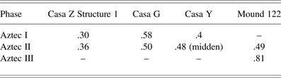
The study of Aztec II contexts suggests that substantial changes took place during Aztec II times. First, during the Aztec II period we see that Xaltocan's existing residents became wealthier. They embellished their homes, increased investment into house construction quality, and increasingly consumed display goods. For example, the Aztec II occupation is associated with a shift to plaster floors in Casa Z Structure 1 and Structure 2. Furthermore, fragments of plaster with red, blue, or yellow paint were recovered from Aztec II deposits of Casa Z, Casa Y, and Casa G suggesting that these houses had painted plaster murals or floors (Brumfiel Reference Brumfiel2010; De Lucia Reference De Lucia2011). Plaster would have been imported to Xaltocan (although it is not certain from where) and represents a substantial increase in labor investment over the earthen floors and clay-covered adobe walls associated with the earlier Aztec I period. In addition, households consumed greater quantities of decorated pottery as the ratio of decorated to plain pottery increased in Aztec I to Aztec II times from .30 to .45 in Structure Z, from .34 to .51 in Casa G, and from .46 to .64 in the domestic refuse to the west of Casa Y, a pattern also observed in Brumfiel's site-wide survey (Reference Brumfiel and Brumfiel2005a). Increased consumption and labor investment into houses associated with the Aztec I–II transition thus suggests that these household economies thrived during the height of Xaltocan's power.
The reuse of the same adobe walls from Aztec I through Aztec II times in Casa Z Structure 2 indicates that there was continuity of occupation through time (Figure 6b). In addition, an intact Aztec II neonate burial from Structure 1 was interred in a simple grave near an adobe wall in the same manner as the burials from the previous Aztec I occupation, further suggesting continuity though time. Thus, the adoption of Aztec II pottery does not appear to coincide with a shift in population within these structures. All of the Aztec I–II houses were abandoned by a.d. 1350, before Aztec III ceramics spread to Xaltocan.
Aztec II–III Houses
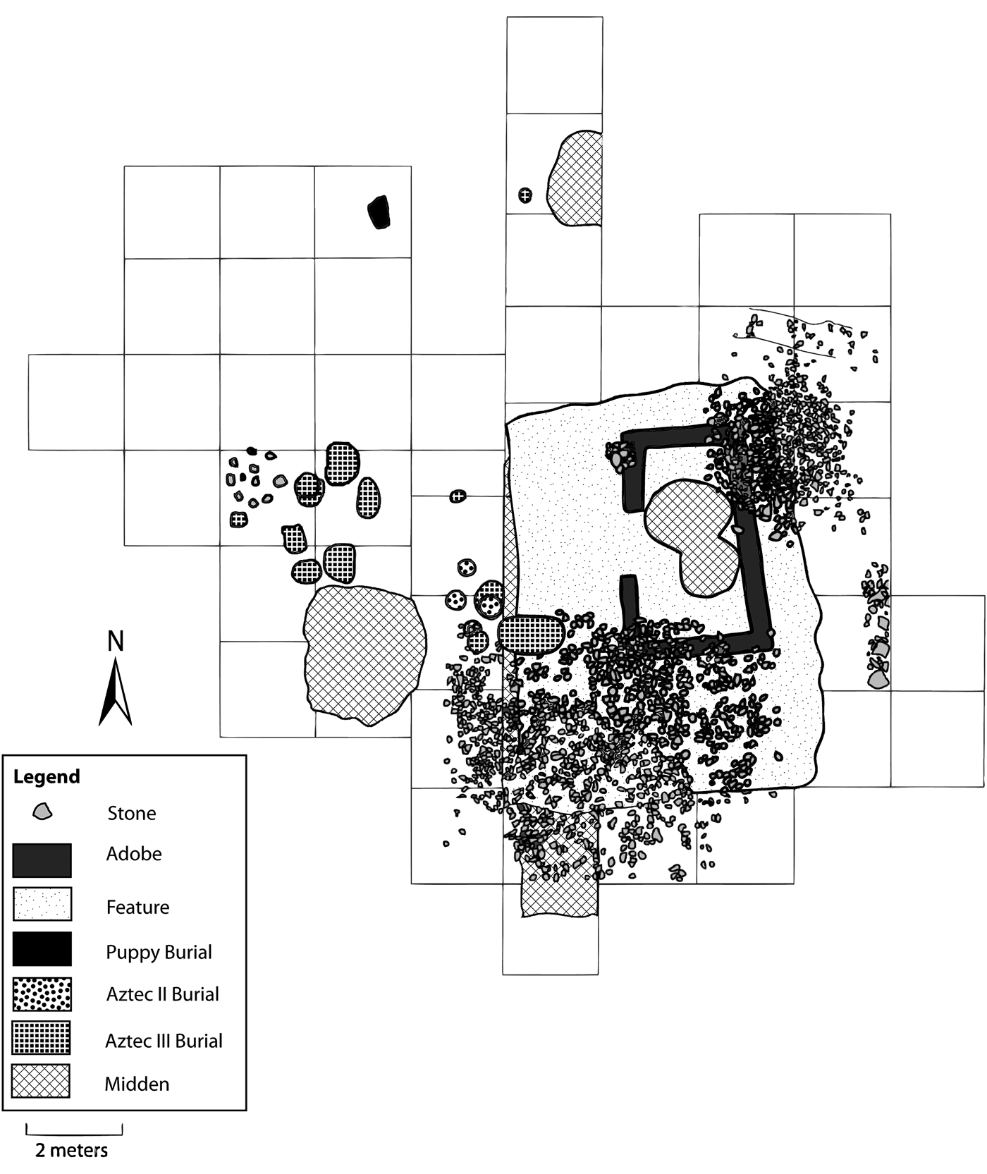
Recent excavations conducted by Overholtzer on Mounds 122 and 124, located on the southeastern periphery of the former island, uncovered successive houses and burials dating to Aztec II and III times (Overholtzer Reference Overholtzer2012) (Figure 8). Both mounds were composed of fill made up of Aztec I and II pottery and thus were constructed after the other mounds discussed thus far. Here we focus on the excavations on Mound 122, which revealed the remains of four successive single-roomed houses and six middens: three dating to the Aztec II phase, two dating to the Aztec III phase, and one dating to the Early Colonial period (Overholtzer Reference Overholtzer2012, Reference Overholtzer2014). Although Brumfiel (Reference Brumfiel and Brumfiel2005a) originally divided the Aztec II phase into two distinct periods, according to dates recently obtained by Overholtzer (Reference Overholtzer2014), there appears to have been a single Aztec II phase where the houses on Mound 122 overlap temporally with the Aztec II houses described above.
Map of architecture, middens, and burials on Mound 122 demonstrating superimposed structures (adapted from Overholtzer Reference Overholtzer2012).
The earliest structure encountered on Mound 122 was a single room house with packed earth floors and clay foundations and associated with Aztec II pottery (Figure 8). This house was associated with a midden that contained Aztec II Black-on-Orange ceramics and produced a 2-sigma calibrated date range of a.d.1170–1280 (Overholtzer Reference Overholtzer2012:Table 4.1). Bayesian statistical modeling conducted by Overholtzer (Reference Overholtzer2014) indicates a date range of a.d. 1240–1270 estimated at a 95% confidence for this occupation, suggesting that this earliest occupation on Mound 122 overlaps in time with the Aztec I–II houses described earlier. A second construction episode is represented by another single-room structure with clay foundations and a nearby small circular stone structure (possibly a storage bin or sweat bath). This house was also associated with Aztec II pottery and radiocarbon dates taken from two burials associated with the house provided 2-sigma calibrated date ranges of a.d. 1290–1400 and a.d. 1300–1430. A overlying third phase is represented by the fragments of walls with stone foundations. An associated midden with Aztec II–III transitional and Aztec III ceramics provided a 2-sigma calibrated date range of a.d. 1300–1410. A fourth overlying structure was a single-room house with another nearby circular stone structure, a midden, and a group of 13 burials of adults and subadults located outside to the northwest of the structure. This occupation phase was associated with Aztec III Black-on-Orange ceramics. The midden produced a radiocarbon sample calibrated at 2-sigma to a.d. 1280–1400. Many of the accelerator mass spectrometry (AMS) radiocarbon dates taken from the burials had a bimodal distribution at 2-sigma, ranging from as early as a.d. 1310–1360 to as late as a.d. 1390–1440, with the latter range being statistically favored in all cases. One burial had a unimodal distribution of a.d. 1400–1470 at 2-sigma, and two others had bimodal or trimodal distributions wherein the earliest range began at a.d. 1420, firmly indicating that this occupation phase continues after the period of Xaltocan's conquest. During the Colonial period, residents continued to occupy the same house constructed in the previous phase.
There were significant continuities in the placement of houses and burials through time. Each house constructed was similar in placement, orientation, and form as the previous one (see Figure 8), but each was leveled before the construction of a new house. Throughout the occupation phases, domestic features, such as burials, circular stone structures, informal hearths, and fragments of adobe pavers were consistently located to the north and west of the house in what appears to be an exterior patio. Given the small size of the structures, it is likely that most production activities would have taken place on the patio.
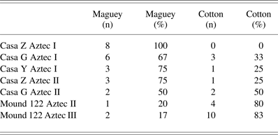
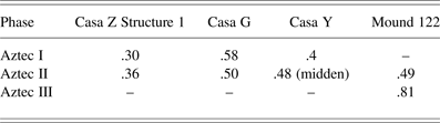
While intact floor contexts were not well preserved on Mound 122, sealed middens in association with domestic architecture provide evidence of household production activities. Small quantities of shell debitage and worked shell fragments provide evidence for small-scale shell ornament production during the Aztec II phase. Furthermore, the presence of worked bone fragments, heat-treated bone, and bone debitage indicate small-scale bone working in Aztec II and III times. Finally, an increase in frequency of spindle whorls from .49 whorls per 100 rim sherds in Aztec II contexts to .81 per 100 in Aztec III contexts reflects an intensification of spinning activities (Table 1). Approximately 80% of the spindle whorls were used for spinning cotton fiber thread in both phases (Table 2).
Spindle whorl frequency per 100 rim sherds
Spindle whorl type according to context
Other activities, however, reflect a decline through time. A decline in salt consumption on Mound 122 from Aztec II to Aztec III times is indicated by the decline of Texcoco fabric-marked pottery from 15.8/100 rim sherds to 2/100. Salt was used as a preservative for meats and fish and as a mordant for textile dyes and was purchased as blocks stored in fabric-marked vessels in Aztec Mexico (Castellón Huerta Reference Castellón Huerta, Manzanilla and Hirth2011; Charlton Reference Charlton1969; Parsons Reference Parsons, Hodge and Smith1994; Williams Reference Williams1999). During the previous Aztec I period, it is likely that inhabitants produced their own salt, possibly using commonly recovered plain crude bowls, since fabric-marked pottery does not appear until Aztec II times in Xaltocan. Given Xaltocan's lacustrine environment and the intensity of fish production and waterfowl exploitation during the previous Aztec I period (De Lucia Reference De Lucia2013), it is likely that the Aztec II inhabitants of Mound 122 also exploited these resources, which would have required large quantities of salt. The high frequency of Texcoco fabric-marked pottery during the Aztec II phase on Mound 122 likely reflects specialized household production of either salted fish or dyed cloth. The marked reduction in salt consumption during the Aztec III phase would thus reflect a decline in importance of these activities. Paralleling this shift, obsidian use fell through time. Aztec I Casa Z had an average of 1.29 pieces of obsidian per 100 rim sherds. On Mound 122 obsidian declined in Aztec II times to .67/100 and again in Aztec III times to .48/100 rim sherds. This trend may reflect reduced access or less need for obsidian due to a decline in productive activities that required obsidian blades.
In contrast, an increase in frequency of spindle whorls over time likely reflects an increased focus on cloth production during the Aztec III phase (Table 1). There is also an increase in cotton spindle whorls through time. Researchers have demonstrated that large spindle whorls with wider diameters were used for spinning maguey fiber, while small whorls with smaller diameters were used for spinning cotton thread (Brumfiel Reference Brumfiel1996; McCafferty and McCafferty Reference McCafferty, McCafferty, Schevill, Berlo and Dwyer1991; Parsons and Parsons Reference Parsons and Parsons1990; Parsons Reference Parsons1972). Although spindle whorls were used for spinning thread and not directly for cloth production, the recovery of weaving tools and cloth production tools from our excavationsFootnote 1 suggests that cloth was indeed being produced in household contexts. Spindle whorls, however, are more likely to preserve in archaeological contexts and are therefore better for comparative purposes across excavations; thus, here we use spindle whorls as a proxy for cloth production. In Aztec I contexts, large spindle whorls for spinning maguey fiber were more common but relatively low in frequency, suggesting that maguey cloth was being produced in low quantities for household consumption. The frequency of spindle whorls increases only slightly during Aztec II times, but there is a shift towards the spinning of cotton fiber (Table 2). In the Aztec III phase, however, cotton spindle whorls predominate. The introduction of Aztec III pottery is associated with the Tepanec expansion (Hodge and Neff Reference Hodge, Neff and Brumfiel2005); thus, it is possible that Xaltocan's households intensified cotton cloth production following its conquest in order to meet tribute demands first imposed by the Tepanecs and later by the Aztecs, as suggested by Brumfiel (Reference Brumfiel1996, Reference Brumfiel2006). Cotton cloth was the most common form of tribute in later Aztec times, and plain cloth mantas also served as a form of currency (Hicks Reference Hicks, Hodge and Smith1994a). This increase in cloth production may have compensated for declines in food surpluses resulting from the abandonment of Xaltocan's chinampa fields following its conquest (Morehart Reference Morehart2014).
In sum, evidence for production activities from Mound 122 suggests that households continued to engage in part-time production activities during the Aztec II period but also became increasingly focused on cotton cloth production through time, as other household production activities declined in importance. As we do not have comparable data from other Aztec III houses, it is difficult to determine how these activities varied between households. This pattern matches regional trends noted by Brumfiel (Reference Brumfiel1996), however, where after Aztec conquest, towns closer to the imperial capital intensified agricultural production, while more distant locales produced more cloth.
Comparison of Aztec II Houses
The Aztec II houses on Mound 122 overlap temporally with the Aztec I–II houses described earlier, but they demonstrate remarkable contrasts. First, these houses do not have a prior Aztec I occupation but were newly constructed in Aztec II times toward the periphery of the site. Second, we see new house construction techniques—unlike the multiroom, multihousehold dwellings associated with the Aztec I–II houses, the houses on Mound 122 are simple, one-room structures that have earthen floors with adobe or clay walls and stone foundations and no plaster floors or murals. Moreover, while there is significant continuity in the placement of the structures through time on Mound 122, each construction episode was represented by the leveling of the previous house and the construction of a new house. In contrast, in the Aztec I–II houses, walls were renovated but were not torn down, suggesting that the house itself was important to the maintenance of social identity (De Lucia Reference De Lucia2010a, Reference De Lucia2014). The burial practices were also different. On Mound 122, individuals were buried outside of the structure, and both infants and adults were recovered. Moreover, on Mound 122 infants were often buried in cooking jars during the Aztec II phase and were more likely than adults to have offerings (Overholtzer Reference Overholtzer2012). In contrast, in the Aztec I–II houses, infants and subadults only were buried in simple graves under house floors and in walls, and infants rarely had grave goods. The final contrast is that the original inhabitants of Xaltocan abandoned the site prior to a.d. 1350, while the later settlers of Mounds 122 and 124 persisted through the Colonial period.
Some of the observed differences between Aztec II populations could be attributed to differences in status. For example, the inhabitants on Mound 122 did not have plaster floors, which require greater labor investment, and they had a lower ratio of decorated to undecorated ceramics (.38) compared to the Aztec II occupation of Casa Z (.45) and Casa G (.51) suggesting that this may have been a lower status household. But, status does not explain the fundamental differences in household organization or burial practices. We argue that that the differences observed between the descendants of the original Aztec I settlers and the occupants of Mound 122 reflect a shift from a culturally homogenous Aztec I community, towards a more diverse settlement during the Aztec II phase resulting from the influx of a new population.
The houses on Mound 122 are similar to single-roomed houses inhabited by members of the Tlahuica, a Nahuatl-speaking ethnic group, at the sites of Capilco and Cuexcomate in Morelos (Smith Reference Smith1992). According to historic documents, the basic Nahua commoner household unit was a calli or single-roomed house that opened onto a patio. Sometimes, kin-related nuclear families placed several calli around one patio to form a patio group (Kellogg Reference Kellogg, Stantley and Hirth1993; Lockhart Reference Lockhart1992). Lockhart (Reference Lockhart1992:62) notes that during the Colonial period, “nuclear families with a single building may have been the most common type,” though this pattern may be the result of demographic collapse and disease. Houses could be added or torn down as needed, and each family would have been responsible for the maintenance of its own house. Further, the circular storage structures associated with each house on Mound 122 reflects a certain degree of “separateness” (Lockhart Reference Lockhart1992). This pattern of household organization is quite distinct from the conjoined houses of the Aztec I period where multiple households likely shared in the construction and maintenance of buildings. Horizontal excavations of houses and burials thus reveal very distinct differences in cultural practices and worldview in Aztec II times, variability that was not previously visible using surface survey and test pitting methods alone.
RECONSTRUCTING XALTOCAN'S HISTORY FROM THE PERSPECTIVE OF HOUSEHOLDS
Household archaeology at Xaltocan has yielded a dynamic history of household and community settlement, organization, and change in the Basin of Mexico. Household excavations have revealed that Xaltocan was settled at the end of the Epiclassic period, a period characterized by political and economic fragmentation following the collapse of the Classic period state of Teotihuacan (Crider Reference Crider2011; Diehl and Berlo Reference Diehl and Berlo1989; Hirth Reference Hirth2000). The site may have been chosen for settlement because of its access to lake resources, its defensible location, or its proximity to important Epiclassic shrines (Morehart et al. Reference Morehart, Peñaloza, Sánchez, de Tapia and Emilio2012), or perhaps a combination of all of these. Regardless of the reason, Xaltocan's first inhabitants accomplished a monumental task: constructing house mounds in the middle of the lake and founding a new community.
The patterns of construction of house mounds in the Aztec I occupation of Xaltocan have important implications for understanding the social and political organization of early Xaltocan. The initial construction of house mounds at Xaltocan was likely organized similar to modern labor exchange groups (see Wilk Reference Wilk1997), where individuals from multiple households voluntarily join together to perform mutually beneficial labor intensive tasks. Stanish (Reference Stanish, Feinman and Nicholas2004:14) argues that people are “predisposed to cooperation” provided that all individuals receive greater benefits than they could through working independently. To date, public architecture or elite structures have not been associated with the Aztec I occupation of Xaltocan and, thus, there is no evidence for a centralized political authority at this time. Moreover, there is little evidence to support a model of social differentiation during Aztec I period Xaltocan, given the apparent similarities in house size, construction techniques, and ritual practices among the four Aztec I houses studied. Instead, the presence of multifamily apartment-like compounds in the Aztec I occupation phase would support a corporate model of social organization (Blanton et al. Reference Blanton, Feinman, Kowalewski and Peregrine1996; De Lucia Reference De Lucia2011; Wolf Reference Wolf1955). In addition to cooperating in daily tasks and rituals, multiple households occupying the same structure also would have worked cooperatively to construct and maintain their houses through time. The construction of Xaltocan's mounds was likely organized by a system of communal leadership early in its history. During the Colonial period there is reference to the persistence of communal governance in some Basin of Mexico communities. Durán (Reference Durán, Horcasitas and Heyden1971:314), for example, parenthetically mentions that some towns were “ruled by...the community” in contrast to others ruled by lords, and López de Gómora (Chimalpahin Cuauhtlehuanitzin Reference Chimalpahin Cuauhtlehuanitzin, Schroeder, Cruz, Roa-de-la-Carrera and Tavárez2010:450) similarly makes reference to “those republics governed communally.” Thus, the precedent for a corporate community organization existed in the Basin of Mexico.
Xaltocan's Aztec I and Aztec II households were also actively involved in production activities and marketplace exchange with each house specializing in the production of different types of goods, rather than simply engaging in household-based subsistence production. Household specialization and exploitation of the surrounding lake environment very likely contributed to Xaltocan's success and rapid growth (De Lucia Reference De Lucia2013; De Lucia and Morehart Reference De Lucia, Morehart, Morehart and De Lucia2015; Morehart Reference Morehart2010, Reference Morehart2014). Such active participation in market systems of exchange ultimately would have contributed to the development of economic differences between households, and potentially the rise of inequality as households became increasingly involved in external systems of exchange (Wilk Reference Wilk1982; Wolf Reference Wolf1955).
The original Aztec I inhabitants of Xaltocan were possibly of Otomi ethnicity as suggested by several lines of evidence. Brumfiel et al. (Reference Brumfiel, Salcedo, Schafer, Hodge and Smith1994) found a widespread distribution of tau-shaped obsidian lip plugs across Xaltocan, which they argue were associated with Otomi ethnicity. Further, the Aztec I inhabitants of Xaltocan spun primarily maguey fiber thread as suggested by the predominance of spindle whorls for spinning maguey during this period. Sahagún (Reference Sahagún, Anderson and Dibble1950–1982 [1575–1577]:10:180) states that “the Otomi women concerned themselves only with maguey fiber.” Additionally, historic accounts indicate that Xaltocan was the capital of the Otomi people (Alva Ixtlilxóchitl Reference Alva Ixtlilxóchitl1975–1977:1:423). Finally, the range of Xaltocan's former domain closely overlaps with modern day Otomi-speaking populations in the northern Basin of Mexico (Carrasco Pizana Reference Carrasco Pizana1950:259; Morehart Reference Morehart2012).
Multiple lines of evidence suggest that by the Aztec II period, Xaltocan's political and economic climate shifted and that power was consolidated. First, Brumfiel's (Reference Brumfiel2005b) excavations revealed two Aztec II stone platforms originally covered with painted plaster murals that likely served as the foundations for public buildings. In addition, it was during this period that the expansion of Xaltocan's chinampas took place (Morehart and Eisenberg Reference Morehart and Eisenberg2010; Morehart and Frederick Reference Morehart and Frederick2014). Finally, historical chronicles suggest that Xaltocan became an important political center starting in the Aztec II period. Xaltocan was said to have been the cabecera (head) of the Otomies and a dominant power in the Basin of Mexico between a.d. 1220 and 1398 (Carrasco Pizana Reference Carrasco Pizana1950:258). Seventeenth-century chronicler Fernando de Alva Ixtliloxóchitl (Reference Alva Ixtlilxóchitl1975–1977:1:306) noted that all of the kings and nobles of Mexico were descended from a handful of “houses,” including Xaltocan, suggesting that rulership was centralized by the Middle Postclassic period.
Yet it is the household excavations at Xaltocan that provide novel insight into this important period of transition. Archaeology reveals that the descendants of the site's original inhabitants became wealthier as they consumed greater quantities of decorated pottery and some embellished their homes with plaster floors and murals. The most dramatic shift was an influx of a new population. Possibly attracted by Xaltocan's growing success, the new group constructed their own mounds and settled towards the periphery of the site, likely because the center of the site was already occupied by the descendants of the earlier Aztec I inhabitants. These immigrants had new ways of organizing their homes, burying their dead, and conceptualizing their everyday lives and worldview, factors that are closely associated with ethnic differences (Stanish Reference Stanish1989). While the new settlers maintained their distinct household organizations and ritual practices, representing perhaps more conservative, nondiscursive cultural traits, they adopted the tau-shaped obsidian lip plugs that served as an outward marker of Otomi ethnicity when they settled in Xaltocan (Overholtzer Reference Overholtzer2012). The new population also appears to have been less wealthy, perhaps as a consequence of their recent immigration, their lack of an established kin-network, or their status as a minority group. Research at other Mesoamerican sites similarly has demonstrated that founding inhabitants tend to become the wealthiest households in later periods (Robin et al. Reference Robin, Yaeger, Ashmore, LeCount and Yaeger2010:331) suggesting that established kin and social networks may have been important factors in household economic success.
The privileged status of the original Aztec I/Otomi inhabitants of Xaltocan was, however, short lived. It appears that they abandoned the site by a.d. 1350, while the new immigrants continued to occupy the site possibly through the colonial period. This exodus may be the historically documented “abandonment” of Xaltocan by the Otomi following Xaltocan's conquest by the Tepanecs in a.d. 1395. This date is almost 50 years later than the archaeologically observed exodus, though the range of error inherent in dating methods and oral histories could account for the discrepancy. Alternatively, it is also possible that the original Aztec I/Otomi inhabitants of Xaltocan started to become wary as they watched Xaltocan's power diminish. Azcapotzalco rose to supremacy in the Valley of Mexico with its conquest of Colhuacan in a.d. 1347 and began its expansion towards Xaltocan's domain at this time (Carrasco Pizana Reference Carrasco Pizana1950:266). Some of Xaltocan's Otomi residents may have decided to leave in anticipation of the events that lay ahead, thereby perhaps even contributing to Xaltocan's conquest. The apparent continuity of occupation on Mounds 122 and 124 throughout the Late Postclassic period, suggests that the new immigrants to Xaltocan did not feel this same pressure.
Interestingly, while the inhabitants of Mounds 122 and 124 adopted Otomi-style lip plugs during the height of Xaltocan's power, they subsequently abandoned them around a.d. 1350, before the polity's downfall and the site's incorporation into the Aztec empire (Overholtzer Reference Overholtzer2012). Brumfiel et al. (Reference Brumfiel, Salcedo, Schafer, Hodge and Smith1994) argue that the reduced frequency of lip plugs recovered from Late Postclassic contexts across Xaltocan suggests that Otomi ethnicity had become devalued and that Xaltocan's inhabitants rejected this ethnic marker and the associated Otomi identity they had previously embraced. Instead, they adopted larger button-shaped lip plugs worn by people of all ethnic groups, including the Mexica (Overholtzer Reference Overholtzer2012). The inhabitants of Mounds 122 and 124 thus proactively distanced themselves from Otomi identity at the same time that Xaltocan's Otomi inhabitants fled. Ethnicity was therefore fluid in Postclassic period Mexico as Xaltocan's commoners actively negotiated their social identities in the face of changing political contexts.
We also argue that there was a shift in Xaltocan's economic organization over the course of the Postclassic period from moderately closed to a more open economy. Drawing from the research of Wolf (Reference Wolf1955), Wilk (Reference Wilk1982) defined two types of community economies: closed communities that are inward looking and mostly autonomous, and open communities that are focused outward and linked to the emergence of external exchange systems. In a closed community, households have little involvement with outside economic systems. They rely on neighbors for support in times of hardship, for sharing risk, and for collaboration on major projects such as house construction. Cooperation and participation in labor groups provide a sense of community solidarity and equality. This sense of group membership is symbolically represented by attempts to suppress expressions of status and wealth in the construction of houses and material possessions (Wilk Reference Wilk1982; Wolf Reference Wolf1955). In contrast, Wilk (Reference Wilk1997) argues that as villages become increasingly integrated into a market economy and excess income exceeds a certain threshold, variability in household status emerges. Because of trade with external markets, households are less dependent upon community support so there is less motivation to conform to community standards since maintaining an appearance of equality is no longer essential (Wilk Reference Wilk1982). Thus, material possessions and houses begin to openly express differences in wealth between households.
Aztec I-period Xaltocan appears to have been an economy in transition. As would be expected in closed village communities, we find that households likely engaged in cooperative labor and there was little differentiation in house construction quality, furnishings, and organization. Aztec I households, however, were not concerned primarily with subsistence production as might be expected, but, rather, were specializing in the production of goods for exchange and were actively involved in the consumption of trade goods. During the Aztec II period, we see increased investment into house construction quality and the consumption of imported display goods such as decorated pottery among Xaltocan's early inhabitants. We also see the emergence of inequality at this time, as new groups settling at the site did not have these same luxuries. Shifts in political economy would influence the symbolic meanings and definitions of material culture, ideology, and social roles as each group attempted to legitimize its social position and undermine that of others.
Ultimately, those households that stayed greatly altered their externally oriented production after the site's defeat and the rise of the Aztec empire changed the direction and intensity of the flow of goods throughout central Mexico, leaving Xaltocan in a more peripheral location in an expanded, Tenochtitlan-centered exchange economy. Domestic economies declined during the Aztec III period as households were saddled with higher tribute demands, narrowed their range of production activities, abandoned chinampa agriculture, and obtained fewer goods through exchange. Xaltocan ceased to produce locally made decorated ceramics and even drastically reduced its production of plainwares, primarily importing plain ceramics from the central basin (Hodge and Neff Reference Hodge, Neff and Brumfiel2005; Peters Reference Peters2002). Xaltocan's interaction with regional exchange systems was thus diminished following its conquest, fostering its dependency on outside markets for the consumption of everyday goods.
The increased production of cloth, a more portable good, as reflected by the rise in spindle whorl frequency in Aztec III times is likely in part a result of increasing tribute demands by the Tepanecs and, subsequently, the Aztec Triple Alliance (Brumfiel Reference Brumfiel, Gero and Conkey1991, Reference Brumfiel1996). Assuming that only women were producing cloth, Hicks (Reference Hicks, Hodge and Smith1994a:99) estimates that it would have taken about 20 weeks for households to supply their own cloth needs and an additional 14 weeks to meet tribute demands, with 18 weeks left over for surplus cloth production. If cloth production involved the collaborative labor of all household members, including children, households may have been able to produce even greater surpluses. The intensification of cloth production in Aztec III times may thus represent production at a level higher than necessary for payment of imperial taxes in order to produce more cloth for surplus exchange. Increased cloth production would reflect changing market strategies of Xaltocan's commoners, as households focused more on producing cloth for market sale and less agricultural production or the extraction of resources from the lake. Xaltocan's residents may have had few other options for surplus production. The fresh water source that fed Xaltocan's chinamapa fields in earlier times had been diverted by the Aztecs (Brumfiel Reference Brumfiel2005b; Morehart and Frederick Reference Morehart and Frederick2014), making large-scale intensive agriculture and its complementary lake exploitation activities a less viable option in Xaltocan's brackish lake. Thus, Xaltocan's recent immigrants persisted through the site's fall and Otomi abandonment, renegotiating their identities, economic strategies, and their place in this once powerful kingdom.
CONCLUSION
Household archaeology at Xaltocan has demonstrated that shifts in political, economic, and social organization through time were closely tied to the decisions and strategies of commoners acting within structural constraints. As noted by Wilk (Reference Wilk1997:8), “while social change viewed from the distance of history can be envisioned as abstract forces acting upon each other, change that is observable in daily life is generated by patterns of individual and group decisions.” It was the actions of ordinary commoners that founded the island site of Xaltocan, contributed to its rise to power, the development of economic inequality, and ultimately the institutionalization of hierarchy. Although Xaltocan's Aztec I inhabitants appear to have been relatively homogenous and suppressed differences in wealth and status, they diversified their production strategies and actively engaged with external markets. During the Aztec I period, Xaltocan's households processed fish, hunted wild game, trapped waterfowl, wove mats, and produced pottery (among other activities) for exchange. They also consumed different goods through exchange. For example, the inhabitants of Casa Z purchased meat, while Casa Y's inhabitants obtained maguey fiber through exchange instead of processing it themselves. These strategies likely continued into the Aztec II period when exchange, household wealth, and agriculture all expanded. Household excavations at Xaltocan thus demonstrate that rather than a consequence of abstract forces acting upon each other, economic growth and development in Xaltocan was a direct result of the strategies and decisions made by ordinary people.
Household excavations also underscore the significance of ethnic interaction with the broader political economy and reveal the means by which individuals negotiate identities in multiethnic settings. The new immigrants to Xaltocan adopted outward expressions of Otomi ethnicity by wearing tau-shaped obsidian lip plugs during the Aztec II period, but they maintained their distinctive burial practices and house construction techniques. Once the Tepanec expansion towards Xaltocan began and Xaltocan's original inhabitants fled the town, however, they rejected these ethnic markers and shifted their social strategies. These new immigrants ultimately contributed to Xaltocan's growth, development, and long-term settlement continuity.
The eventual abandonment of Xaltocan by the descendants of its earliest inhabitants, rather than being a consequence of Xaltocan's conquest, may have in actuality helped to contribute to its downfall. Xaltocan, thus, may have had its own tragedy of the commoners (Pauketat Reference Pauketat, Dobres and Robb2000). But all residents did not make the same choices; some decided to resist Tepanec control by fleeing, while others persisted—despite conquest, increasing tribute demands, and a declining standard of living—by altering their economic and social strategies. Xaltocan's dynamic history thus demonstrates how micro- and macro-structures work to constitute one another during periods of rapid change and development in ancient polities.
RESUMEN
La arqueología de las unidades domésticas en el sitio de Xaltocan en el norte de la cuenca de México ilustra cómo las acciones cotidianas de la gente común pudieron contribuir al surgimiento y caída de los sistemas políticos antiguos. Fundada alrededor del año 900 d.C., Xaltocan se elevó rápidamente para convertirse en un estado importante y poderoso en el período preazteca. Sin embargo, la supremacía de Xaltocan fue de corta duración y, como muchas otras organizaciones políticas en el centro de México, finalmente fue incorporada al imperio azteca. En este artículo preguntamos qué factores contribuyeron al surgimiento y la caída de Xaltocan. Las crónicas históricas que documentan la historia de México se concentran en las alianzas, conquistas, y genealogías de la élite política, y construyen un “discurso público” (Scott Reference Scott1990), que enmascara las acciones cotidianas de la gente común. Sin embargo, sostenemos que, para comprender el ascenso y la caída de los sistemas políticos antiguos como Xaltocan, debemos reconstruir una narrativa que integre la infrapolítica (Scott Reference Scott1990), las estrategias y las acciones de las personas no documentadas en relaciones históricas para nuestra mejor comprensión del pasado. Utilizando un estudio de larga duración sobre el cambio y la variación de los contextos domésticos en Xaltocan, este artículo reconstruye cómo las actividades económicas y políticas de los hogares plebeyos fueron fundamentales para la construcción y reproducción de las instituciones políticas, las estructuras sociales y los sistemas regionales de intercambio en el centro de México. Primero, analizamos la organización y las estrategias domesticas en el período Azteca I, el tiempo de crecimiento de Xaltocan para convertirse en un poder regional, y afirmamos que el ascenso al poder de Xaltocan pudo haber sido en gran parte instigado por las actividades económicas y políticas de los hogares ordinarios. Luego, examinamos la continuidad y el cambio en las actividades diarias durante el auge de Xaltocan, la época Azteca II, e interpretamos que hubo un influjo de una nueva población durante este tiempo. Finalmente, analizamos el período Azteca III, cuando el poder de Xaltocan se desvaneció, y consideramos cómo los plebeyos contribuyeron y fueron afectados por el descenso en la supremacía de Xaltocan. Concluimos que las unidades domésticas no fueron simplemente influenciadas por los procesos regionales de cambio y desarrollo, sino que las micro y macroestructuras se constituyeron mutuamente, y que las decisiones y acciones de la gente común tuvieron consecuencias intencionales y no intencionales a mayor escala.
ACKNOWLEDGMENTS
This research was conducted with the permission of Mexico's Instituto Nacional de Antropología e Historia, the town of Xaltocan, and the González-Sánchez and Arenas Ramírez families. The projects also benefited from support of the Xaltocan cultural center and the Gran Señorio de Xaltocan Historical Society. This material is partially based upon work supported by the National Science Foundation under a Minority Postdoctoral Research Fellowship grant (De Lucia Reference De Lucia2011:1103522). De Lucia's research was also made possible through funding by a Dissertation Fieldwork Grant (2007:7706) from the Wenner-Gren Foundation for Anthropological Research, a National Science Foundation Doctoral Dissertation Improvement Grant (2007:0742249), an Association for Feminist Anthropology Dissertation Award, Graduate Research Grants from the University Research Grants Committee at Northwestern University, and research grants from the LeCron Foster and Friends of Anthropology at Northwestern. Overholtzer's research was supported by a Dissertation Fieldwork Grant (2009:7797) from the Wenner-Gren Foundation for Anthropological Research, a National Science Foundation Doctoral Dissertation Improvement Grant (2009:0968551), a Young Explorer Grant from the National Geographic Society, a Grant-in-Aid of Research from the Sigma Xi Foundation, a National Science Foundation Graduate Research Fellowship, a Graduate Research Grant from the University Research Grants Committee at Northwestern University, and a Research Grant from the LeCron Foster and Friends of Anthropology at Northwestern. This paper was previously presented in a session organized by Scott Hutson and Cynthia Robin at the AAA meetings in 2012 and we would like to thank them both for inviting us to participate in the session and volume. We would like to thank Santiago Juarez for helping to create the figures and maps. We would also like to thank Cynthia Robin, Scott Hutson, Santiago Juarez, Stacie King, and several anonymous reviewers for their helpful comments on earlier drafts of this manuscript. Any errors are strictly our own. Finally, this article would not have been possible without the previous research and support of Elizabeth Brumfiel, who introduced us to Xaltocan and helped us develop our projects there. We dedicate this article to her memory.