Archaeological research has traditionally focused on areas with visible architecture, given that those regions are most recognizable as places that contained ancient activity, but it has neglected the open spaces between them. Many researchers in Mesoamerica interested in the ancient use of open spaces have focused their efforts on exploring formalized patios and plazas (e.g., Cap Reference Cap2015; Coronel et al. Reference Coronel, Hutson, Magnoni, Balzotti, Ulmer and Terry2015; Fulton et al. Reference Fulton, Christian Wells and Storer2017; Low Reference Low2000; Manzanilla and Barba Reference Manzanilla and Barba1990; Rothenberg Reference Rothenberg (Fulton), Tsukamoto and Inomata2014; Tsukamoto and Inomata Reference Tsukamoto and Inomata2014; Wells Reference Wells2004). Less attention has been given to nonformalized space, such as the areas between residences. Few studies exist whose primary focus is these interstitial spaces (e.g., Fash Reference Fash, Urban and Schortman1986; Johnston Reference Johnston2004; Robin Reference Robin2002, Reference Robin, Hendon and Joyce2004, Reference Robin2013; Robin and Rothschild Reference Robin and Rothschild2002; Webster and Gonlin Reference Webster and Gonlin1988). Yet, these open areas contain an abundance of potential data for archaeologists exploring everyday life. They could have been used for many purposes, such as for informal or formal gatherings of residents, as a walkway to agricultural fields or to neighbors (Robin Reference Robin2002), or as lithic manufacturing areas (Yaeger Reference Yaeger, LeCount and Yaeger2010).
This research examines the relationship between these open areas on the landscape and the development of shared community identities in Actuncan, Belize. Such shared identities would have created deep historical ties to specific community spaces, which would have enabled and constrained political expansion during the Terminal Classic period (ca. AD 800–900). If engagement with local landscapes helped define shared social and political identities among Actuncan residents, then we might expect to find patterns in material culture that characterize areas of social distinctiveness within and outside architecture. For example, tasks involved in food production shared among residents, such as lime slaking corn or large-scale cooking (both of which require cooperation and coordination), may mark locations where practices of affiliation were materialized and reproduced (Joyce Reference Joyce2000; Stockett Reference Stockett2005). Other shared activities, such as commensal feasting, certain types of craft production, and communal ritual activities, also could have inscribed the landscape with affiliative practices (Deal Reference Deal1998; Kramer Reference Kramer1985; LeCount Reference LeCount2001; McAnany Reference McAnany1994; Stockett Reference Stockett2005). Alternatively, if local landscape connections did not play a significant role in identity formation, then we would not expect to find shared practices outside residential contexts. Instead, identity formation would have developed in the context of strong ties between kin groups that were not necessarily linked to the landscapes surrounding the residences.
In this article I consider the nature and location of activity patterns in and around three contemporaneous residential groups to infer shared practices and identities that those activities both enabled and constrained. Interpretations are drawn from excavation data, macroartifact and microartifact analyses, and soil chemical residue analysis. The data suggest that activities conducted in architecturally defined spaces were distinct from activities conducted in the interstitial spaces between them. I argue that community identity, which may have been developed and maintained through shared practices among residents, in addition to their perceived connection to the communal landscape, likely influenced the decisions of many to remain at Actuncan despite the unstable political climate in the region. The extent of inter- and intrahousehold relationships may have established the framework for broader-scale political dynamics and explain how Actuncan rulers may have been able to create and maintain authority during the Terminal Classic.
Shared Practices, Built Environments, and Community Identity
Mesoamerican archaeologists have argued that neighborhoods played important, diverse, and functional roles within cities because of the social ties created among community members (Arnauld et al. Reference Arnauld, Manzanilla and Smith2012; Ashmore et al. Reference Ashmore, Yaeger, Robin, Demarest, Rice and Rice2004; Cowgill Reference Cowgill2004; Fletcher Reference Fletcher2009; Hutson et al. Reference Hutson, Hixson, Magnoni, Mazeau and Dahlin2008; Marcus and Sabloff Reference Marcus and Sabloff2008; Smith Reference Smith2010; Yaeger and Canuto Reference Yaeger, Canuto, Canuto and Yaeger2000; York et al. Reference York, Smith, Stanley, Stark, Novic, Harlan, Cowgill and Boone2011). Social ties often evolve into a shared group identity: an important building block for communities because it provides a sense of connection to place that integrates people at various social levels (Burke Reference Burke and Butler1989; Gillis Reference Gillis and Gillis1994; Le Goff Reference Le Goff, Randall and Claman1992). Shared identity provides an individual with social memories and meanings that can be applied to understanding, experiencing, and interpreting material life, in addition to fostering a common sense of self and awareness (Hendon Reference Hendon2010; McAnany Reference McAnany1994). In the prehispanic Maya region, group identities were often physically inscribed on the landscape in the form of architecture, orchards, fields, and forests (McAnany Reference McAnany and Houston1998). Here, I use the term “landscape” to denote the physical spaces, both open and bounded by architecture, within which activities took place.
Daily activities and engagement with the material world entangle social meaning, values, and relationships (Allison Reference Allison1999; Hutson Reference Hutson2010; Robin Reference Robin2002, Reference Robin, Hendon and Joyce2004; Wells and McAnany Reference Wells and McAnany2008). Additionally, spaces in which people reside and perform these tasks often affect the meanings and values associated with the activities themselves (Ashmore Reference Ashmore, Hendon and Joyce2004; Ashmore and Knapp Reference Ashmore and Knapp1999; Hendon Reference Hendon, Meskell and Preucel2004, Reference Hendon2010; Lawrence and Low Reference Lawrence and Low1990; Smith Reference Smith2003). The physical landscape is inclusive of the empty spaces between visible architecture (Anschuetz et al. Reference Anschuetz, Wilshusen and Scheick2001). Through social practices, actors transform physical spaces—a realm of possibilities with which people can interact—into places imbued with meaning through human experience and engagement (de Certeau Reference de Certeau1984). The sociocultural production of space and place affects the way people operate on an everyday basis and, in turn, is influenced by human activities (Lefebvre Reference Lefebvre and Nicholson-Smith1991 [1974]). The combination of shared practices and the communal landscapes on which they occur creates, transforms, and maintains community identity (Knapp and Ashmore Reference Knapp, Ashmore, Ashmore and Knapp1999; Whitridge Reference Whitridge2004).
The shared identity of a group can manifest in a variety of tangible ways, such as through shared “practices of affiliation” (Yaeger Reference Yaeger, Canuto and Yaeger2000:125). Practices of affiliation are defined as beliefs and behaviors that contribute to the creation and expression of community identity or the way of perceiving and experiencing an individual's social world. Further, these practices help make the community distinct and recognizable as a group, both to group members and those outside the community. For example, Yaeger argues that shared community identity at San Lorenzo, Belize, was reinforced by practices of affiliation, including feasts sponsored by local leaders. Certain activities supported a sense of “local community identity while simultaneously highlighting differences between the members of that community” and those outside it. In addition, spatial proximity contributed to a high level of interaction between community members; “through daily interaction, people build social relationships and tacitly acknowledge similar beliefs about the world and how to act within it” (Yaeger Reference Yaeger, Canuto and Yaeger2000:131, 130).
Stockett applies Yaeger's “practices of affiliation” approach to Las Canoas, Honduras, to investigate “the ways that identity unites and divides individuals and groups” (2005:4). She developed a model for locating affiliative practices in archaeological contexts on three interrelated and overlapping scales: household, community, and region. In Belize, LeCount (Reference LeCount1999) uses a practice-oriented framework to investigate the shared activities involving Mount Maloney pottery vessels in residential spaces at Xunantunich and its surrounding countryside. She argues that Mount Maloney pottery represented distinct relationships and “that everyday practices in which these very common pottery types were used embodied an identity based on kin, ancestors, and place on the landscape, which in turn came to be symbolized by the pottery itself” (LeCount and Yaeger Reference LeCount, Yaeger, LeCount and Yaeger2010a:345). In their investigation of household ritual activities, McAnany (Reference McAnany1994, Reference McAnany and Houston1998) and Walker and Lucero (Reference Walker, Lucero, Dobres and Robb2000) argue that royal rituals may have developed from the domestic ritual practices of local lineage groups. Although research on households and communities has been influential in expanding our understanding of ancient Maya social relations in small-scale settlements (e.g., Allison Reference Allison1999; Canuto and Yaeger Reference Canuto and Yaeger2000), the nature and role of identity affiliations in larger settlements remain poorly understood (Yaeger and Canuto Reference Yaeger, Canuto, Canuto and Yaeger2000).
Actuncan in Context
Actuncan is located in the upper Belize River valley near the modern town of San Jose de Succotz and the Guatemalan border (Figure 1). The settlement is roughly 2 km north of Xunantunich, the Late Classic provincial center of the region (Ashmore Reference Ashmore, LeCount and Yaeger2010; LeCount and Yaeger Reference LeCount, Yaeger, LeCount and Yaeger2010b; Leventhal and Ashmore Reference Leventhal, Ashmore and Garber2004). It rests on a T-3 alluvial terrace west of the Mopan River, a tributary of the Belize River. The Mopan River flows all year and provided a consistent supply of freshwater to prehispanic residents (Fedick Reference Fedick, McAnany and Isaac1989; Smith Reference Smith1998). Additionally, this waterway allows direct access to the Caribbean coast, providing a transportation route for goods and people (Cap Reference Cap2015).
Map of the upper Belize River valley showing Actuncan and other archaeological sites (LeCount Reference LeCount2004:Figure 1). Note: The size of the triangle does not represent the relative site size.

The rugged upland terrain of the Belize River valley includes enclosed depressions and residual hills with gray and brown soils of the Toledo Beds that are predominantly calcareous mollisols and vertisols (Beach et al. Reference Beach, Luzzadder-Beach, Dunning, Scarborough, Gomez-Pompa, Allen, Fedick and Jiménez-Osornio2003; Day Reference Day1993). Underlying the area is a karst belt that runs through central Belize. The Cretaceous to Early Tertiary period limestone substrate is composed primarily of calcium, barium, and strontium (Day Reference Day1993). The soils are mostly acidic with a range of 5.5–6.5 on the pH scale and are often less than 0.5 m thick. Probes at the northern portion of Actuncan have reached depths over 3 m; limestone bedrock was not readily available as a source of construction material.
With 14 ha of civic and domestic buildings, Actuncan is similar in size to neighboring centers and is a prime example of a low-density urban center as defined by Smith (Reference Smith2010). The area was first settled in the Middle Preclassic period (ca. 1000–400 BC), but all construction from this time was buried when the entire ridgetop was leveled in preparation for the construction of a planned urban center (Mixter Reference Mixter2016). During the Late Preclassic period (ca. 400 BC–AD 250), Actuncan was established as a planned political and ceremonial center and contained monumental civic constructions including an E-Group and a triadic temple group (McGovern Reference McGovern2004; Mixter et al. Reference Mixter, Fulton, Hahn and LeCount2014). Actuncan initially rose to political prominence during the Late Preclassic extending into the Early Classic period (ca. AD 250–600; LeCount Reference LeCount2004). In the Early Classic, competition between Actuncan and Buenavista del Cayo escalated until Buenavista del Cayo eclipsed Actuncan (Ball and Taschek Reference Ball, Taschek and Garber2004; LeCount and Yaeger Reference LeCount, Yaeger, LeCount and Yaeger2010a, Reference LeCount, Yaeger, LeCount and Yaeger2010b; Leventhal and Ashmore Reference Leventhal, Ashmore and Garber2004; McGovern Reference McGovern2004).
During the Late Classic period (ca. AD 600–800), Xunantunich became established as the provincial political center of the region (LeCount and Yaeger Reference LeCount, Yaeger, LeCount and Yaeger2010b). The population of the settlement zone surrounding Xunantunich, which includes Actuncan, doubled from the Early Classic to Late Classic, demonstrating the increased political importance of the polity (LeCount and Yaeger Reference LeCount, Yaeger, LeCount and Yaeger2010b). Because of Actuncan's proximity to Xunantunich, people who remained around its community core were integrated into the polity of Xunantunich. Actuncan was likely a subordinate center in the Late Classic (Mixter et al. Reference Mixter, Fulton, Hahn and LeCount2014).
Xunantunich, along with much of the Mopan Valley rural hinterland, experienced demographic decline and eventual abandonment during the Terminal Classic period (ca. AD 800–900), sparking the political resurgence of other nearby communities (LeCount and Yaeger Reference LeCount, Yaeger, LeCount and Yaeger2010b). Rather than declining in parallel with Xunantunich and other secondary centers, Actuncan gained independence and was ruled corporately by a governing council, a new form of political organization in the area (Mixter Reference Mixter2017). Residential units at Actuncan adopted a variety of social and economic strategies for survival as the local community reformed its social and political institutions following the decline of Xunantunich, although the details of these strategies are poorly understood (Mixter et al. Reference Mixter, Fulton, Hahn and LeCount2014). Despite the ongoing reorganization of many Maya polities at this time, Actuncan remained a viable center into the Postclassic (Mixter et al. Reference Mixter, Fulton, Hahn and LeCount2014).
Little is known regarding how Actuncan residents managed to thrive in the context of rapidly changing demographics. Community ties among residents may have influenced the decisions of many to remain at Actuncan. Further, because of the long occupation history of the settlement, group identities may have been tied to local landscapes. The extent of inter- and intrahousehold relationships may have established the framework for broader-scale political dynamics and enabled rulers at Actuncan to create and maintain authority.
The Northern Settlement
This research focuses on the Northern Settlement, an area located northwest of the Actuncan civic-ceremonial core. This zone houses numerous residential groups in close proximity that contain permanent stone architecture. At least six patio-focused groups, several single mounds and platforms, and a series of agricultural field complexes have been identified. This investigation focuses on three residential groups—Groups 1, 5, and 6 – all of which were occupied during the Terminal Classic (Figure 2). Their spatial proximity and contemporaneity suggest that group residents interacted with one another on a daily basis and possibly maintained a close relationship (Robin Reference Robin2002, Reference Robin, Hendon and Joyce2004, Reference Robin2013; Robin and Rothschild Reference Robin and Rothschild2002). Additionally, these three groups are located close to important site center architecture, including an E-Group, ball court, and public plaza. Spatial proximity to the settlement center may have influenced residents’ day- to-day activities. Group 1 consists of four buildings situated on a raised platform and is the largest plazuela on the ridgetop, both in terms of area and mound size (Antonelli and Rothenberg Reference Antonelli, Rothenberg, LeCount and Keller2011; LeCount Reference LeCount2004; LeCount and Blitz Reference LeCount and Blitz2002, Reference LeCount and Blitz2005; LeCount et al. Reference LeCount, Blitz and Kelso2005; Rothenberg Reference Rothenberg (Fulton), LeCount and Blitz2012). Excavations have uncovered a long, albeit interrupted, occupation sequence, dating from the Late Preclassic to the Postclassic. Terminal Preclassic crypts at Group 1 suggest the group was a founding residential unit in the Northern Settlement (LeCount Reference LeCount, LeCount and Blitz2012; LeCount and Blitz Reference LeCount and Blitz2002). Group 5 is smaller, also consisting of four buildings oriented around a central patio on a raised platform. In contrast to Group 1, these constructions are not arranged symmetrically around the patio space nor do they fully enclose the patio. Rather, a wide entryway is located in the southeast corner, facing a large plaza space. Group 5 was founded after Group 1, during the Terminal Preclassic, and was continuously occupied into the Terminal Classic (Hahn Reference Hahn, LeCount and Blitz2012). Group 6 comprises two apparent buildings, possibly surrounding a patio space to the south and facing toward Group 1; excavations suggest the group was not occupied for a long time, likely only during the Terminal Classic and possibly during the latter part of the Late Classic (Simova Reference Simova, LeCount and Blitz2012).
Map of Actuncan with the study area identified. (Modified from LeCount et al. Reference LeCount, Christian Wells, Jamison and Mixter2016:Figure 2)

Field Methods and Research Design
A sampling strategy was designed to collect macroartifacts, microartifacts, and soils for multielemental analysis across the formally defined residential groups and the spaces between them. Before this project was begun, large-scale excavations were conducted at Group 1, and so this area was sampled in a different manner from the rest of the sample area. Soils were available for chemical analysis from Group 1 because samples were collected before excavations, but the area was not sampled for macro- and microartifacts. The field methods employed for this study follow the sampling strategy developed by Keller and Craiker (Reference Keller, Craiker, LeCount and Blitz2012), based on methods originally outlined by Fry (Reference Fry1972). This research aims to go beyond architecturally bounded space visible today to explore open spaces between architecture in attempts to better understand residential relationships in the context of one continuous landscape. This exploration of interstitial areas is aligned with other research at Actuncan (Blitz et al. Reference Blitz, Nelson, Salberg, LeCount and Blitz2012; Millar Reference Millar, LeCount and Mixter2016; Walker Reference Walker, LeCount and Blitz2012) and elsewhere (Johnston Reference Johnston2004).
Using standard manually operated clam-shell style posthole diggers, excavators created 515 uniform 19 cm diameter holes along a predefined grid from which to systematically collect overlapping datasets of macroartifacts, microartifacts, and soils for multielemental analysis. The sampling area encompassed Group 1, Group 5, and Group 6 architecture, in addition to all other open spaces in between and surrounding surface visible architecture (hereafter referred to as “the space between groups”). The space between groups was sampled using a 5 m lattice grid matrix, whereas architectural space was investigated using a 2.5 m staggered grid matrix.
Often, archaeologists analyze artifacts collected from a ¼ inch screen during excavations. Here, I refer to artifacts larger than ¼ inch as macroartifacts. Macroartifacts are often subject to disturbance, whether in antiquity with the cleaning of a space or in modern times through field plowing. Most macroartifacts associated with activities are swept or carried away from their primary contexts (Deal Reference Deal1985; Hayden and Cannon Reference Hayden and Cannon1983; Kramer Reference Kramer1982; LaMotta and Schiffer Reference LaMotta, Schiffer and Allison1999; Siegel and Roe Reference Siegel and Roe1986). For this study, I selected a subset of postholes (n = 74) from which to also collect microartifacts (those less than ¼ inch in size). Compared to macroartifacts, microartifacts tend to move little (vertically or horizontally) from where they were originally deposited on the surface because they are often incorporated into the occupation surface by trampling (Gifford Reference Gifford and Gould1978; Gifford-Gonzalez et al. Reference Gifford-Gonzalez, David Damrosch, Pryor and Thunen1985; Hayden and Cannon Reference Hayden and Cannon1983; Killion Reference Killion1990; Nielsen Reference Nielsen1991; Schiffer Reference Schiffer1983). Therefore, microartifacts are more likely to survive over time than macroartifacts in an open area that may have been regularly cleaned or otherwise disturbed. Comparing macro- and microartifact distributions can bring further insight to activity locations, especially in combination with other methods.
Additionally, I collected soil samples for chemical residue analysis from each posthole. The underlying premise of chemical residue analysis is that specific chemical compounds are generated from repeated human activities (e.g., cooking, toolmaking). The elements are deposited into the activity surface and fixed to soil particles. The deposition and distribution of chemical elements can be linked through ethnoarchaeological and experimental studies to a variety of human tasks involving food preparation and consumption, among other activities (Barba and Ortiz Reference Barba and Ortiz1992; Barba et al. Reference Barba, de Pierrebourg, Trejo, Ortiz and Link1995; Manzanilla and Barba Reference Manzanilla and Barba1990; Wells and Moreno Cortés Reference Wells and Moreno Cortés2010; Wells and Terry Reference Wells and Terry2007). Therefore, chemical residue analysis of living surfaces provides essential data to reconstruct the activities that took place in ancient spaces (Wells et al. Reference Wells, Terry, Parnell, Hardin, Jackson and Houston2000). This method has become increasingly popular throughout Mesoamerica as a tool to explore past human behavior. Researchers have used chemical residue analysis to explore plazas, middens, marketplaces, palaces, and houselots, among other contexts (e.g., Anderson et al. Reference Anderson, Bair and Terry2012; Cook et al. Reference Cook, Kovacevich, Beach and Bishop2006; Dahlin et al. Reference Dahlin, Jensen, Terry, Wright and Beach2007; LeCount et al. Reference LeCount, Christian Wells, Jamison and Mixter2016).
I used inductively coupled plasma-mass spectrometry (ICP-MS) using the Foss mild acid-extraction technique (0.60 M HCl + 0.16 M HNO3, trace metal grade) to characterize chemical concentrations of soil samples (Lewis et al. Reference Lewis, Foss, Morris, Timpson and Stiles1993). I chose an extraction procedure, rather than total digestion of the samples, for chemical analysis because this research focused on anthropogenic residues, not the total composition of the soil (Wells Reference Wells2010). Additionally, high elemental concentrations exhibited in total digestion samples can overwhelm the comparably small anthropogenic inputs (Middleton and Price Reference Middleton and Price1996). In sum, this study used multiple lines of evidence from independent datasets at diverse spatial scales of analysis. Analyzing a combination of overlapping datasets contributes to a deep level of understanding of the residential environment.
Group 1 Excavations
As mentioned, large-scale excavations were conducted at Group 1 before posthole testing, and those Group 1 excavations focusing on the Late and Terminal Classic occupation layers are summarized in this section (for detailed descriptions of Group 1 excavations, see Antonelli and Rothenberg Reference Antonelli, Rothenberg, LeCount and Keller2011; Freiwald Reference Freiwald, LeCount and Blitz2012; Freiwald and Micklin Reference Freiwald, Micklin and LeCount2013; Fulton Reference Fulton and LeCount2015a, Reference Fulton2015b; Heindel Reference Heindel and LeCount2015; LeCount Reference LeCount2004; LeCount and Blitz Reference LeCount and Blitz2002, Reference LeCount and Blitz2005; LeCount et al. Reference LeCount, Blitz and Kelso2005; Rothenberg Reference Rothenberg (Fulton), LeCount and Blitz2012).
Evidence for Late Classic occupation at Group 1 was recovered from all structures, even though building activities were sporadic and small-scale. Although all Group 1 structures have evidence of occupation during the Terminal Classic, only the southern structure, Structure 61, shows architectural modification at this time. Residents focused their architectural efforts on the enlargement of Structure 61 by using large (>50 cm) dry laid chert cobbles to enlarge this structure by at least 1 m. This type of construction appears to be the hallmark of Terminal Classic construction at Actuncan and is distinct from the densely packed cobble, soil, and midden fill used during the Late Classic (Mixter et al. Reference Mixter, Fulton, Hahn and LeCount2014). Structure 61 fronts a public plaza and was therefore visible by many people, so it is possible that the augmentation of the structure was an attempt to highlight the social status of Group 1 residents.
During the Late and Terminal Classic, the patio space next to the eastern structure, Structure 60, was used as a burial ground (see Freiwald Reference Freiwald, LeCount and Blitz2012; Freiwald and Micklin Reference Freiwald, Micklin and LeCount2013; Fulton Reference Fulton2015b for full burial descriptions). Ten burials have been identified to the west of Structure 60, containing a minimum number of 14 individuals, although it is possible more burials are present.
The excavated burials were interred within the patio fill and placed in close proximity to each other (Freiwald Reference Freiwald, LeCount and Blitz2012; Freiwald and Micklin Reference Freiwald, Micklin and LeCount2013). Nearly all the graves were disturbed, likely from the placement of later interments, and most burials included elements from other individuals or were missing body parts. Although there is evidence to support repeated burial ground use, analysis of radiocarbon dates is ongoing to determine the precise chronology (see LeCount Reference LeCount and LeCount2015 for initial data).
Throughout the Maya region, eastern structures functioned as sacred ground for the burial of important household members, thus operating as a shrine for ancestor veneration (Helmke et al. Reference Helmke, Grube, Awe, Helmke and Awe2006; McAnany Reference McAnany1994). Not all community members were buried in eastern shrines, but these locations were often used as shared burial locations for different residential units (Aimers et al. Reference Aimers, Powis and Awe2000). The large number of burials identified west of Structure 60 suggests the building's function as an ancestral shrine, and the time span of those interments suggests the area was used for this purpose over several generations. From the manner in which individuals were disturbed, we can infer that the space itself held as much importance as a ritual location as the individual graves.
Results
In this section I highlight the results from analyses of the macroartifacts, microartifacts, and soil chemistry. I also discuss how the datasets complement one another in the interpretation of the findings.
Macroartifacts
The 2,369 macroartifacts analyzed in this study show that activity areas were mostly concentrated around architecture. To analyze macroartifacts, samples were first divided into artifact class and then counted and weighed. As expected, because of the nature of open spaces, the numbers of macroartifact per posthole were low (ranging from 1 to 34 total macroartifacts per posthole), with many postholes (n = 164) producing no macroartifacts. The macroartifact numbers were also small in size, making ceramic diagnostics challenging. Nonetheless, several Late and Terminal Classic diagnostic ceramic artifacts were identified, including 82 ash-ware (unspecified types and forms), two Mount Maloney (types unspecified), six Belize Red type (forms unspecified), and one Alexander Jar piecrust rim.
Overall, ceramic artifacts account for the highest percentage of artifacts and had the widest range in terms of types; as a class, they have a large standard deviation (Table 1). High ranges and standard deviations mean the deposition of the material class varies spatially and is not homogeneous across the study region. The only artifact class with a higher standard deviation than ceramic artifacts is jute, but this is due to an outlier. Chipped stone is the only other category with a noticeably large range and standard deviation.
Summary Statistics for Macroartifacts.

Note: Postholes that yielded 0 artifacts were not figured into calculations.
* Coefficient of variation = (standard deviation/mean) × 100.
To examine the spatial distributions of a selection of macroartifact classes, I employed spatial interpolation using Kriging (Entwistle et al. Reference Entwistle, McCaffrey and Dodgshon2007; Wells et al. Reference Wells, Novotny, Hawken, Glascock, Speakman and Popelka-Filcoff2007), a form of semi-variogram modeling that situates the data in a broader context of spaces not sampled (see Wells Reference Wells2010). The resulting images represent densities of each variable as it changes over space. I selected Kriging for these datasets to be consistent with the analysis and data presentation for the soil chemical analyses described later. For spatial analysis, I chose three material classes for examination—ceramic artifacts, daub, and chipped stone—to examine and compare the distribution of macroartifacts and microartifacts at various scales. Additionally, these categories varied the most when considering all macro- and microartifact categories. Spatial distribution maps for macro-ceramic artifacts, macro-daub, and macro-chipped stone appear in Figure 3. Macro-slate and macro-obsidian quantities were not high enough to consider making spatial distribution maps, but because of their rarity and importance, their locations were mapped onto the macro-chipped stone spatial distribution maps. Given that Group 1 was not sampled in the same manner as the rest of the sample area, this area of the spatial distribution maps is blocked out in white and is not considered in this part of the analysis.
Spatial distributions of macro-ceramic artifacts (left), macro-daub (middle), and macro-chipped stone (right).

Spatial distributions for all macroartifact classes are concentrated around architecture, although their distributions vary. There are high macro-ceramic artifact levels within Group 5 and Group 6, and macro-ceramic artifacts extend to the spaces just beyond Group 1 but are mostly absent in the rest of the sample area. Macro-daub is only found in the western part of Group 6 and surrounding it. Elevated macro-chipped stone concentrations appear in the same areas with high macro-ceramic artifact quantities in Group 5, whereas the rest of the space contains few macroartifacts. The macro-obsidian and macro-slate are randomly distributed and not associated with architecture or the presence of other material classes. All macroartifact categories suggest that activities were mostly concentrated in areas associated with architecture.
Microartifacts
The 74 microartifact samples analyzed in this study indicate that activity areas are associated with architecture and areas between architecture. It is notable that there are few microartifacts compared to macroartifacts. This could be due to sampling loci placement, postdepositional processes that helped preserve macroartifacts, or recovery methods. To analyze microartifacts, each sample was divided into three size fractions using nested screens. The size fractions include (1) over ¼ inch—Fraction 1, (2) between ¼ inch and ⅛ inch—Fraction 2, and (3) between ⅛ inch and  inch—Fraction 3). The artifacts in the largest fraction, Fraction 1, are not technically considered microartifacts, but they were collected and analyzed to use as a comparison to macroartifacts collected from the same locations. Like macroartifacts, microartifacts were first sorted by material class. All classes were weighed, and some classes were counted.
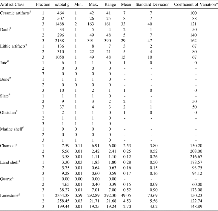
As with the macroartifacts, ceramic artifacts as a class account for the highest quantity, the widest range, and the largest standard deviation in Fraction 1 (Table 2). Chipped stone has the next highest quantity, range, and standard deviation, followed by daub. Fraction 2 follows a similar pattern with the exception of range, where daub represents the highest range, followed by ceramic artifacts and then chipped stone. In Fraction 3, daub surpasses ceramic artifacts in quantity, range, and standard deviation, with ceramic artifacts following close behind, and, finally, chipped stone.
Summary Statistics for Microartifacts.

Note: Postholes that yielded 0 artifacts were not figured into calculations.
* Coefficient of variation = (standard deviation/mean) × 100.
#Artifact classes displayed by counts.
gArtifact classes displayed by weight in grams.
Because of the wider spacing between microartifact sample locations, spatial distributions were mapped using point density maps rather than Kriged interpolations. Point density maps for all fractions of micro-ceramic artifacts, micro-daub, and micro-chipped stone appear in Figures 4, 5, and 6, respectively. As with macroartifacts, micro-slate and micro-obsidian locations were identified individually on the micro-chipped stone maps, and Group 1 is blocked out.
Point density maps showing the distribution of micro-ceramic artifacts by fraction.

Point density maps showing the distribution of micro-daub by fraction.

Point density maps showing the distribution of micro-chipped stone by fraction.

At the largest fraction, Fraction 1, the micro-ceramics distribution appears rather homogeneous, with only one large concentration in the northwest. Areas containing higher quantities of micro-ceramic artifacts become apparent as the scale is decreased, with high concentrations within and between architecture in Fraction 2 and high concentrations more constrained to architecture in Fraction 3. Considering all three scales, there were a variety of areas where activities involving ceramic artifacts occurred, both in relation to architecture and the spaces between.
The micro-daub distribution appears constrained to architectural areas. The highest quantities appear in association with the eastern structure of Group 6, whereas the micro-daub from Group 1 extends beyond the formal patio space. Group 5 does not contain high micro-daub concentrations, suggesting different building strategies were used there. Significant quantities of micro-daub are present only in Fraction 3 between architecture.
A majority of the high micro-chipped stone concentrations appear off-structure. Areas with elevated micro-chipped stone levels are present to the northeast of Group 5 and Group 1 in similar locations relative to the architecture, but this pattern is not repeated at Group 6.
Additionally, at the smallest scale, Fraction 3, a variety of areas containing high micro-chipped stone quantities are present between residential groups. Many, although not all, of the micro-slate artifacts appear associated with the micro-chipped stone concentrations, whereas micro-obsidian artifacts appear to be distributed more randomly.
Soil Chemical Residues
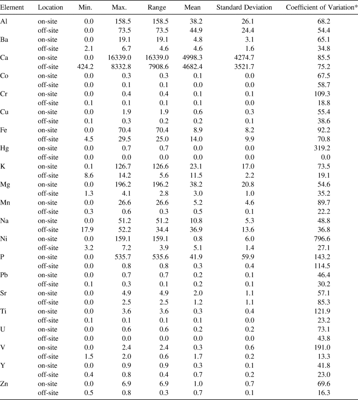
The 711 soil samples analyzed in this study (703 on-site samples, 8 off-site controls) show different patterns for Group 1 than for the rest of the sample area. After determining the calibrated concentrations of 21 elements (Table 3), the results were reported in parts per million (ppm) of the element. Overall, the chemical data showed less than 5% variation on the NIST CRM (U.S. National Institute of Standards and Technology Certified Reference Material) for all standards and samples (including replicates) and less than 5% error on internal quality control (blanks).
Summary Statistics for Soil Chemical Data.

Note: Results reported in ppm; 0.00 indicates levels are below the detection limits of the ICP-MS.
* Coefficient of variation = (standard deviation/mean) × 100.
Generally, for activity analysis, the most useful elements are those whose datasets have large ranges and high standard deviations, meaning that the element deposition varies spatially and is not homogeneous across the study area (Wells et al. Reference Wells, Novotny, Hawken, Glascock, Speakman and Popelka-Filcoff2007). For the on-site samples, many elements do have wide ranges and several outliers. As expected with the off-site controls, ranges for all elements are significantly lower than for the on-site samples. The differences in elemental concentrations between off-site controls and on-site samples are presumably due to the chemical additions from human activity.
I conducted principal components analysis using a correlation matrix and discriminant function analysis on a selection of the chemical data from the on-site samples. Visual representations of the results for each analysis are summarized in Figure 7 as scatterplots. In the scatterplot for the principal components analysis, the numbers in parentheses show component loadings. Both analyses suggest that the samples from Group 1 have distinctly different chemical signatures from the rest of the samples. Differing chemical signatures suggest that activity loci within the sample area varied by location. More specifically, ancient activities practiced in Group 1 differed from those conducted in the rest of the sample area.
Scatterplot of the first two factor scores from principal components analysis (top) and the first two functions from discriminant function analysis (bottom). Numbers in parentheses show component loadings.

Kriging was used to examine the spatial distributions of a selection of elements. The spatial distribution maps presented in Figure 8 show examples of chemical distributions highlighting P, Fe, and Mn. In each map, darker shades indicate higher concentrations of the given element. It should be noted that higher elemental concentrations do not necessarily reflect the intensity or longevity of the activity responsible for the deposition of that element, given that activity characteristics are affected by numerous long-term processes that differentially affect elemental deposition and retention (see Bethell and Máté Reference Bethell, Máté and Henderson1989; Hammond Reference Hammond1982). The deposition of P is often linked to organics, such as those used for food preparation and/or consumption (Wells and Terry Reference Wells and Terry2007; Wells et al. Reference Wells, Novotny, Hawken, Glascock, Speakman and Popelka-Filcoff2007). The homogeneous P distribution suggests that not only the patio groups but also the empty spaces between architecture were heavily trafficked in a generalized way. The higher concentrations surrounding and within Group 1 suggest that activities in these areas were more focused and perhaps specialized than in other areas or that the group residential population was higher than the other groups.
Spatial distributions of extractable soil P (left), Fe (middle), and Mn (right).

Deposition of Fe is often associated with ferric oxide, a mineral commonly employed in ceremonial contexts including rituals using ochre and hematite (Vázquez and Velázquez Reference Vázquez, Velázquez, Macri and McHargue1996; Wells et al. Reference Wells, Terry, Parnell, Hardin, Jackson and Houston2000; Wells and Terry Reference Wells and Terry2007). If the Fe deposition patterns resulted from pigment use, the open area between Group 1 and Group 6, as well as possibly Group 1 itself, may have been used for special residential ritual functions. Deposition of Mn is often associated with organic refuse disposal and likely with the disposal of items used in food preparation or of leftovers from food consumption (Parnell et al. Reference Parnell, Terry and Nelson2002). The large areas of high Mn concentrations extending past Group 1 architecture may indicate that Group 1 hosted food-related activities for a large number of participants, who thus disposed of waste across a widespread area.
Discussion
Locations with elevated concentrations of macroartifacts, microartifacts, and chemical elements appear in many parts of the sample area. Nevertheless, not all enriched loci are associated with visible architecture. Data interpretation from the Northern Settlement demonstrates that Actuncan Terminal Classic residents interacted with architectural zones, such as residential groups, as well as the spaces between and surrounding them. Activities conducted in different areas seem to have been distinct from one another, suggesting a compartmentalization of space.
Quantitative analyses of the chemical data suggest that ancient activities practiced at Group 1 differed from those that occurred in other locations, as might be expected due to the overall size and time depth of the group. The high P concentrations, often associated with food consumption and preparation, and Mn, related to organic refuse disposal, surrounding Group 1 suggest that the location-specific activities surrounding Group 1 may have included the use of food, possibly for ceremonial feasting. I suggest that food presence may indicate feasting given that others have argued for ceremonial feasting at nearby contemporary settlements (e.g., LeCount Reference LeCount2001; Yaeger Reference Yaeger, Canuto and Yaeger2000). Elevated Fe levels, linked with iron oxide, at Group 1 could point to ritual activities. Hematite and ochre, both composed of iron oxide, were common minerals used throughout the Maya region in ceremonial contexts, including burials and caches (Vázquez and Velázquez Reference Vázquez, Velázquez, Macri and McHargue1996).
Higher macroartifact and microartifact levels also appear near Group 1. Perhaps the daub surrounding Group 1 resulted from temporary perishable structures for activities involving high quantities of ceramic artifacts and chipped stone either produced by the residents or possibly by itinerant attached artisans (Heindel Reference Heindel and LeCount2015; Kovacevich Reference Kovacevich, Wells and Davis-Salazar2007).
The distinct signatures of Group 1 and its immediate surroundings may indicate that it was a locus for specialized activities, in addition to those associated with basic domestic tasks and practices. These activities could have been affiliative practices or community events that included members from other nearby residential units. The perishable structures represented by the high daub quantities might have accommodated other community members involved in the affiliative ritual practices or craft production. Alternatively, perishable structures may have covered outside work areas, such as for stone tool production or large-scale food preparation.
Excavation data from Group 1 suggest residents used Structure 60 for burials over several generations. Although Structure 60 was repeatedly used to inter and venerate the dead, no similar deposits are evident in other residential units at Actuncan, suggesting the importance of Group 1's residents or its location or both. The sequential manner in which the individuals were buried, with each new burial disturbing a previous one, suggests that the space itself held as much importance as a ritual location as the individual graves (Freiwald Reference Freiwald, LeCount and Blitz2012). Perhaps the emphasis on locale also suggests a tie to the long occupation history of Group 1. Founded in the Late to Terminal Preclassic and containing the earliest documented patio-focused group in the Northern Settlement, Group 1 was occupied until the Postclassic. Perhaps the selection of Group 1 as the location for specialized activities was connected to the ancestral ties (real or perceived) of the Group 1 residents to the founders of the original Preclassic residence. Possibly others participating in shared rituals also traced their decent to the same ancestors. This pattern would mirror what Gonlin (Reference Gonlin1993) documented in the Copan Valley, where households exhibited strong ties to focal residences. By associating themselves with a shared heritage in a common location, ancestral veneration practices would have increased a sense of community among residents involved (see Vogt Reference Vogt1976:111–115; Wisdom Reference Wisdom1940:197–198). If Group 1 was a focal residence, was it the only one in the Northern Settlement? Alternatively, were there occupation clusters, each with distinct focal residences?
Shared practices at Actuncan could have helped reinforce social ties and a sense of community affiliation and identity. With the collapse of surrounding political structures during the Terminal Classic, strong social ties between Actuncan community members may have motivated people to stay in the places their ancestors had occupied for generations, rather than abandon them. If this was the case for the residences in the sample area, was this also the case for the greater Actuncan residential community (or at least those in the Northern Settlement)? Through this research, I aimed to provide insight into social strategies employed by residents to maintain their communities following the reorganization of political power in the region.
Nevertheless, the exact nature of community social ties remains unclear. Can these types of relationships even be identified given the coarseness of the archaeological record? What other data might contribute to our understanding of community identity? Questions such as these can help form the foundation for further exploration into social practice and shared identity.
Acknowledgments
This research was conducted under permits issued by the Institute of Archaeology, National Institute of Culture and History, Government of Belize, to Lisa LeCount (permit number IA/H/2/1/14(12)). Thanks to the institute for supporting this research, especially John Morris and Jaime Awe, and its staff for help exporting materials from Belize to the United States. This research was funded by the National Science Foundation (Grant BCS-0923747 and Grant BCS-1418480). Field and laboratory work would not have been possible without the dedicated effort of local men and women from San Jose de Succotz. Thanks to the Galvez and Juan families for permission to excavate on their properties. I am particularly grateful to Chena and the staff at Clarissa Falls for continuously providing a hospital environment for the Actuncan Archaeological Project members. Finally, I would like to thank a number of mentors and colleagues who have given constructive feedback throughout this project: Christian Wells, Lisa LeCount, David Mixter, Bernadette Cap, Rebecca Zarger, Robert Tykot, and David Lewis.
Data Availability Statement
Macroartifact, microartifact, and chemical data presented in this paper can be obtained from the Digital Archaeological Record (tDAR), doi:10.6067/XCV83R0V68, https://core.tdar.org/dataset/398973.