NORTHUMBERLAND
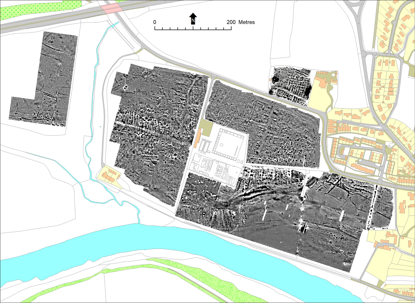
(1) Corbridge, Roman station and town (NY 97825 65032, NY 98338 65214): an ongoing integrated programme of geophysical survey and aerial photographic analysis examined the area in and around the English Heritage Guardianship Area (fig. 8).Footnote 23 Gradiometry survey results revealed the presence of a substantial barn-like building, 50 m by 20 m, south-west of the Guardianship Area. The building lies on the west side of Dere Street as it approaches the Roman bridge over the Tyne, just beyond the furthest extent of the Edwardian excavations. Other notable results include further traces of the earthworks observed at Bishop Rigg in 1974 and the discovery of intensive Roman activity at Shorden Brae, an area otherwise known archaeologically only for its second-century mausoleum.Footnote 24 A reappraisal of aerial photographic evidence has employed Structure-from-Motion and Multi-View-Stereo (SfM-MVS) image matching methods to create multi-epoch orthomosaics and Digital Surface Models which are being used to characterise landscape change within the Scheduled Area.
Greyscale magnetometry plot of the area around Corbridge Roman station. The geophysical survey results shown north of Corchester Lane, at the Corchester Lane Sports Ground, were produced by Wardell Armstrong for English Heritage in a separate survey and are reproduced here with their permission.

CUMBRIA
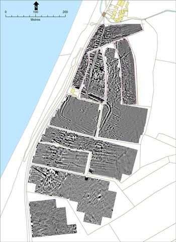
(1) Beckfoot, Roman fort, extramural settlement and cemetery (NY 0897 4885): a range of survey techniques focused on the intra- and extramural areas of Beckfoot Roman fort have expanded the known extent of settlement through gradiometry survey, resistivity survey of the fort interior and drone survey (fig. 9).Footnote 25 The extent of the fort is visible through its defensive ditches, with a road leading from both the north and south gates through extramural settlement; the latter consisted of linear plots typical of strip-buildings seen at other Roman extramural settlements. The settlement north of the fort appears to be denser than that to the south. Inside the fort, the position of the principia is visible.
Gradiometer survey of Beckfoot Roman fort and environs. The image incorporates (with permission) results derived from a separate gradiometer survey undertaken for the Maryport and District Archaeology Society (MADAS) in 2014 by Wardell Armstrong Archaeology in the first, second and fourth fields from the north-east.

COUNTY DURHAM
(1) Binchester (NZ 2102 3134): excavation in the cemetery area south-east of the fort encountered further inhumations, bringing the total number of excavated graves to 30. All graves consisted of extended inhumations, and preserved nails indicated burial in wooden coffins. A small number of graves were furnished, including one with a crossbow brooch and another with copper-alloy bangles and beads. This part of the cemetery appears to date to the fourth century, succeeding possible agricultural use indicated by numerous ditches and gullies.Footnote 26
(2) Piercebridge (NZ 2105 1575): geophysical survey revealed a pattern of ditched trackways to the west of the fort — one which ran parallel to the western fort defences and another leading towards the west gate of the fort. These appear to relate to masonry buildings found in 2009. There does not appear to be any settlement pre-dating the establishment of the fort.Footnote 27
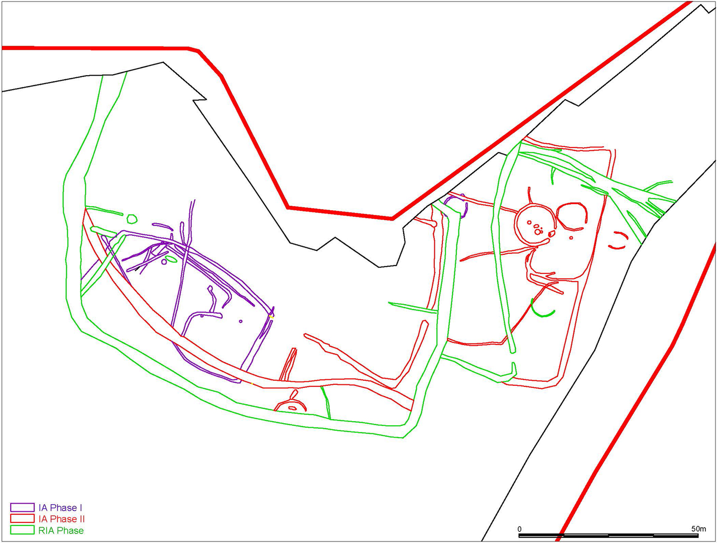
(3) Sedgefield, Eden Drive (NZ 35961 28520): excavation of a 2.6 ha area focused on a rectilinear enclosure previously identified through geophysical survey (fig. 10). The enclosure consisted of at least two phases of Iron Age occupation and a subsequent phase of Roman occupation. The earliest phase of Iron Age occupation was characterised by a single unenclosed roundhouse with a diameter of 6 m, revealed by a surviving drip gully and two truncated central pits, with an entrance to the north-east. Narrow intercutting ditches and possible droveways c. 70 m west of the roundhouse are thought to be associated with the structure, demarcating a roughly rectangular-shaped area. The second phase of Iron Age occupation consisted of a roundhouse with a diameter of 10 m, revealed by a ring-groove construction slot with a south-east-facing entrance and an internal hearth. This structure was associated with a sub-circular enclosure, with both inside a rectilinear enclosure bordered by possible droveways. A larger rectilinear enclosure was found west of the roundhouse, containing a second internal ditch and an entrance at its eastern end. The Roman occupation was characterised by a larger recut and extension of the second phase of the Iron Age rectilinear enclosure with the addition of further boundary ditches to the east. No structural deposits were encountered in the Roman phase, though the enclosure encompasses the hilltop immediately north of the excavation area. Roman ceramics and a large fragment of a possible voussoir box-tile typical of bath-house roofs may suggest a Roman building was located nearby.Footnote 28
Sedgefield. A plan of the Phase I Iron Age features (purple), Phase II Iron Age features (red) and Roman Iron Age features (green) identified at Eden Drive. (© ARS 2018)

NORTH YORKSHIRE
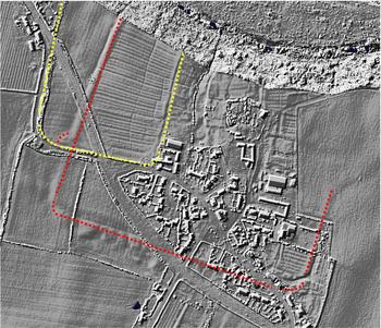
(1) Dalton on Tees (centred on NZ 2968 0806): small-scale excavations confirmed identification of at least one, possibly two, previously unrecognised Roman fort(s) initially identified through LiDAR images and earthworks immediately adjacent to the scheduled villa site.Footnote 29 The larger fort has a probable area of c. 16 ha, the smaller fort an area of c. 6 ha (fig. 11). Excavation at one location revealed a V-shaped ditch, and a succession of three ditches with a narrow berm in front of a timber box-rampart. Only one piece of Roman ceramic was recovered from excavation.Footnote 30
Dalton on Tees. Roman fort (red) and possible earlier, smaller fort (yellow) as seen on LiDAR. (LiDAR source: https://houseprices.io/lab/lidar/map)

(2) Aldborough, Low Lane (SE 40624 66447): a single trench was located to test the survival of the north range of the Roman forum and establish a basic chronology. Three of the four phases attest to Roman activity, starting in the Flavian period (c. a.d. 69–96), with post-Flavian forum construction and use and late Roman robbing and activity. Ceramics, animal bone and environmental assemblages have been recovered.Footnote 31
(3) York, Bishophill (SE 59972 51403): a Romano-British altar was recovered from the demolition fill of a nineteenth-century cellar during a watching-brief. The altar may have been reused as a Victorian garden feature; carved from local gritstone, it was decorated with a patera (libation bowl) and a jug. A human skull of unknown date was also recovered from the construction cut of a former inspection chamber (manhole).Footnote 32
(4) South Stainley: hoard of 11 silver denarii: Nero, 1; Vitellius, 1; Vespasian, 5; Trajan, 3; Sabina, 1. Probably deposited c. a.d. 117–138 or later.Footnote 33
(5) Arkendale: hoard of 12 silver denarii and 1 copper-alloy sestertius. Denarii: Titus, 1; Domitian, 1; Trajan, 3; Hadrian, 1; Antoninus Pius, 1; Lucilla, 1; Marcus Aurelius, 1; Geta, 1; Septimius Severus, 1. Sestertius: Antoninus Pius. The coins were found in two main concentrations and appear to represent two separate deposits, thought to have been deposited c. a.d. 202 or later.Footnote 34
(6) Wheldrake: hoard of 188 Constantinian copper-alloy nummi and three fragments: a.d. 317‒24, 67 (London, 14; Trier, 20; Lyon, 15; Arles, 5; Ticinum, 3; Siscia, 4; uncertain, 5; irregular, 1); a.d. 324‒30, 51 (London, 2; Trier, 27; Lyon, 2; Arles, 7; Rome, 1; Ticinum, 1; Cyzicus, 1; uncertain, 10); a.d. 330‒5, 54 (Trier, 29; Lyon, 6; Arles, 3; Aquileia, 1; Siscia, 2; uncertain, 13); a.d. 335‒41, 10 (Trier, 2; Lyon, 1; uncertain, 7); a.d. 341‒8, 6 (Trier, 5; uncertain, 1). Probably deposited c. a.d. 347–348 or later.Footnote 35
EAST RIDING OF YORKSHIRE
(1) Rudston: hoard of 12 silver siliquae, heavily clipped: a.d. 353‒6, 2 (Arles or Lyon, 1; ?Trier, 1); a.d. 367‒78, 2 (Trier); a.d. 379‒88, 1 (Trier); a.d. 388‒95, 1 (Trier); a.d. 395‒402, 5 (Milan); irregular, 1. Probably deposited c. a.d. 395–402 or later.Footnote 36
WAKEFIELD
(1) Wakefield: hoard of 17 copper-alloy nummi: a.d. 335‒341, 3 (uncertain); a.d. 341‒8, 2 (Arles, 1; uncertain, 1); a.d. 353‒61, 4 (Arles, 1; Rome, 1; uncertain, 2); a.d. 388‒402, 1 (uncertain). The Theodosian nummus is thought to be a later stray and not part of the main group, probably deposited c. a.d. 355–361 or later.Footnote 37
HUDDERSFIELD
(1) Kirklees, Upper Fell Greave (SE 1429 2016): LiDAR data have suggested a more easterly direction for Margary M712 that runs east from the fort at Slack to where it crosses the river Calder, possibly near to Cooper Bridge. Limited fieldwalking and probing identified stretches of a roadway with an approximate width of 7 m.Footnote 38
LANCASHIRE
(1) Lancaster, St George's Quay, Quay Meadow (SD 4726 6224): evaluation excavation in three trenches located c. 210 m from the outer earthworks of the Roman forts produced evidence of Roman structures and a road surface probably associated with the Roman course of the river Lune. The structures in trench 1 had no datable finds associated with them but consisted of two stone walls probably of different phases. A structure in trench 2 appears to consist of both external and internal walls of cobble-and-clay construction and at least partial sandstone flagging. Post-holes indicate a wooden structure associated with the external face of the eastern exterior wall; fragments of slate roof-tiles were recovered. An abraded decorated samian sherd (Form 27) associated with the edge of a wall dates to c. a.d. 80–110, with further undecorated Form 27 sherds recovered.Footnote 39
(2) Lancaster, Hillside (SD 47275 61925): evaluation excavation identified Roman deposits surviving below post-medieval deposits inside the extrapolated area of the fourth-century Roman fort, consisting of a pebbled road surface overlying post-holes. Unstratified finds included late Roman coarsewares and a sherd of decorated samian.Footnote 40
(3) Ribchester: the site of the Roman bridge over the Ribble at Ribchester has never been certain, made more difficult by the changing position of the river since the Roman era. LiDAR has revealed the precise courses of the roads from Manchester and York as well as the probable link road from Ribchester. LiDAR has also revealed several relict river courses, allowing the position of the Roman bridge to be inferred. It is suggested that the bridge site would have been where the three roads (from Manchester, York and Ribchester itself) all aligned (SD 6567 3518), which corresponds to a palaeochannel of the Ribble (fig. 12). A road agger is visible in the field approaching the suggested bridge site.
Ribchester. Suggested Roman bridge location based on where the three known Roman roads would have met and an old river channel.

NORTH LINCOLNSHIRE
(1) Stallingborough, Stallingborough Interchange (TA 19581 12842): geophysical and fieldwalking surveys followed by evaluation provided evidence for a rural settlement occupied throughout the Roman period, with a bias toward the later Roman centuries. Remains included prominent ditches and evidence for two structures, one of which had associated painted wall-plaster. An incomplete kiln or oven was identified. East of the main settlement, further ditches and post-holes were revealed, with one ditch containing an assemblage of unabraded pottery dated to the second to third centuries; an exceptional quantity of environmental evidence was recovered from this area.Footnote 41
LINCOLNSHIRE
(1) Holton le Clay, Hornsea Offshore Wind Farm Project One SMR 4 (Plot 31) (TA 29379 01781): excavation identified linear boundaries accompanied by ring-gullies providing evidence for Iron Age/Romano-British settlement. The ring-gullies enclose areas of c. 12.5 m2, though there was no evidence for hearths or artefacts associated with these features. Rectilinear enclosures extend beyond the site; the north–south spine of the enclosure complex traversed the east of the site and to the west a substantial ditch may have defined the northern area of a ‘D’-shaped enclosure extending to the south of the site.Footnote 42
(2) Cowbit, Backgate (TF 2644 1776): archaeological evaluation revealed five multi-phase ditches of Roman date, one of which probably related to a late Roman settlement to the immediate north-east of the site explored in 2010; the remaining features may be part of an earlier phase of settlement activity first identified during fieldwalking undertaken in 2001.Footnote 43
(3) Cowbit, Moulton Chapel Road (TF 2673 1800): archaeological evaluation identified a sequence of Roman and medieval deposits as well as undated features. A pit and a ditch, both of which are probably third century in date, were the only certain Roman features excavated, although the discovery of these does contribute to the known evidence of settlement in the vicinity. Two additional ditches were also recorded, although these produced no datable artefactual evidence. The site lies within an area dominated by Iron Age and Roman settlement and salt-making centres, established along the levees of former courses of the river Welland. Roman features incorporated domestic food waste and indicated that the surrounding landscape was open and possibly marshy.Footnote 44
(4) Gedney: a hoard of 32 copper-alloy sestertii and 38 dupondii or asses: Domitian, 1; Trajan, 6; Hadrian, 3; Antoninus Pius, 4; Faustina I, 3; Marcus Caesar, 1; Faustina II, 1; Marcus Aurelius, 1; Faustina II, 2; ?Lucius Verus, 1; Commodus (under Marcus), 2; Commodus, 3; uncertain Antonine, 3; Caracalla, 1: Julia Domna, 1; Severus Alexander, 1; Julia Mamaea, 1; Gordian III, 1; Philip I, 1; uncertain emperor, 33. Probably deposited c. a.d. 249 or later.Footnote 45
(5) Revesby: a hoard of 55 copper-alloy nummi: a.d. 310‒17, 1 (London); a.d. 317‒24, 43 (London, 14; Trier, 11; Lyon, 2; Arles, 1; uncertain mint, 15); a.d. 324‒30, 11 (London, 6; Trier, 3; Arles, 1; uncertain mint, 1). Probably deposited c. a.d. 327–8 or later.Footnote 46
SUPPLEMENTARY MATERIAL: CONTENTS
For Supplementary Material for this article please visit https://doi.org/10.1017/S0068113X18000338