Aguadas are the most common water resource in the southern Maya Lowlands. Naturally occurring aguadas originate from collapse or dissolution sinkholes (Monroe Reference Monroe1970). They are usually found at the margins of bajos (larger karst depressions) and along the fractured bedrock of karst uplands (Siemens Reference Siemens, Harrison and Turner1978). Most of the naturally occurring aguadas in the vicinity of ancient Maya settlements were later lined by the Maya with clay, plaster and/or stone-facing to improve their ability to hold water (Adams Reference Adams and Ashmore1981; Ancona Reference Ancona1889; Wahl et al. Reference Wahl, Schreiner, Byrne and Hansen2007). However, aguadas could also be human-made depressions, such as ancient quarries that were later transformed to store water (Bullard Reference Bullard1960; Dunning et al. Reference Dunning, Akpinar, Carr, Griffin, Jones, Lentz, Miller, Prater, Urquizú and Saturno2007; Hester and Shafer Reference Hester and Shafer1984; Weiss-Krejci and Sabbas Reference Weiss-Krejci and Sabbas2002). Given the seasonality of available precipitation and the porous nature of the karst landscape of the southern Maya Lowlands, aguadas were likely a significant aspect of ancient Maya daily life.
Historically, numerous aguadas have been identified in the Maya Lowlands, though only a few have been studied as valuable sources for paleoenvironmental and archaeological data (e.g., Dunning et al. Reference Dunning, Jones, Beach, Luzzadder-Beach, Scarborough, Valdez and Dunning2003; Wahl et al. Reference Wahl, Byrne, Schreiner and Hansen2006). In March and April of 2005 and 2007, a University of Cincinnati research team undertook archaeological and paleoenvironmental investigations, under Nicholas P. Dunning's supervision, in several aguadas near the ancient Maya sites of San Bartolo and Xultun in northeast Peten, Guatemala in order to gain insight into the histories of these communities within the context of environmental change and adaptation (Dunning et al. Reference Dunning, Chmilar, Blevins, Jones, Urquizú and Saturno2005, Reference Dunning, Akpinar, Carr, Griffin, Jones, Lentz, Miller, Prater, Urquizú and Saturno2007). Our investigations revealed valuable information about local land use, environmental change and water-management systems around San Bartolo and Xultun during the ancient Maya period.
STUDY AREA
The Peten makes an attractive study area for archaeological and paleoenvironmental investigations since its physical environment remained considerably intact after the 1697 Spanish seizure of Tayasal until 1970, though rapid change has occurred since then (Schwartz Reference Schwartz1990). San Bartolo and Xultun are situated in the Three Rivers physiographic region along the fractured eastern edge of the central Peten Karst Plateau, consisting of stepped escarpments dividing karst uplands and lowland bajos (Dunning et al. Reference Dunning, Beach, Farrell and Luzzadder-Beach1998). Both San Bartolo and Xultun are located to the south of the sprawling Bajo de Azúcar and alongside Bajo Itz'ul to the west and northwest. Seasonal swamps and vertisol soils predominate within these bajos. Ixcan Río is the only river close to San Bartolo and Xultun, connecting several small bajos east of the two sites before draining into the Bajo de Azúcar. The river largely desiccates during the dry season (Garrison Reference Garrison2007; Garrison and Dunning Reference Garrison and Dunning2009).
The climate of the northeast Peten is classified as Köppen Am with a tropical wet/dry climatic regime. The majority of the rainfall in the region occurs during late May to December, and the dry period is experienced between January and May (Dunning et al. Reference Dunning, Jones, Beach, Luzzadder-Beach, Scarborough, Valdez and Dunning2003; Wahl et al. Reference Wahl, Schreiner, Byrne and Hansen2007). In Peten, the annual rainfall varies between 900 to 2,500 mm with a regional average of 1,600 mm. Additionally, the interannual variation in rainfall is unpredictable, as the seasonal migration of the Inter Tropical Convergence Zone and the Azores-Bermuda high pressure system varies on both short- and long-term temporal scales (Mueller et al. Reference Mueller, Islebe, Hillesheim, Grsesik, Anselmetti, Ariztegui, Brenner, Curtis, Hodell and Venz2009; Rosenmeier et al. Reference Rosenmeier, Hodell, Brenner, Curtis and Guilderson2002).
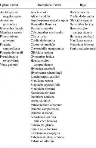
The biodiversity in the Peten forests is not as rich as the tropical forests of Costa Rica or rain forests of the Amazon. Nonetheless, the Peten still enjoys substantial species diversity (Reining and Heinzman Reference Reining, Heinzman, Plotkin and Famolare1992). The modern vegetation around and between the sites of San Bartolo and Xultun include upland, transitional and bajo forests (Table 1). The perennially or seasonally wet depressions formed by aguadas typically include sedges, ferns and grasses, and arboreal species that are common to transitional upland forests. Additionally, as freshwater ecosystems, aguadas act as important habitats to a number of mammals, avifauna, fish, gastropods and zooplankton (Goulden Reference Goulden1966; Lohse Reference Lohse, Valdez and Lohse2004; Moholy-Nagy Reference Moholy-Nagy1978; Reyes Reference Reyes, Enriquez, Morales and Avila2004).
Upland, transitional, and bajo forests San Bartolo-Xultun intersite area identified by David L. Lentz

AGUADAS OF SAN BARTOLO AND XULTUN
San Bartolo (16 Q 245036 E, 1940939 N) and Xultun (16 Q 243368 E, 1934323 N) are two ancient Maya sites that are 8 km distant from one another in northeast Peten. Both were significant Preclassic period centers. San Bartolo is a mid-sized site that occupies an area of 4 km2, whereas Xultun includes a very large settlement area that covers at least 16 km2 (Garrison Reference Garrison2007; Garrison and Dunning Reference Garrison and Dunning2009). San Bartolo is particularly well known due to the existence of the earliest known examples of Maya writing and mural paintings dating to the third and second centuries b.c. (Saturno et al. Reference Saturno, Stuart and Beltran2006). San Bartolo, abandoned at the end of the Late Preclassic period, was resettled briefly during the Late Classic period, probably as settlement pushed outward from Xultun. The city of Xultun developed into one of the largest Classic period Maya centers in the region, becoming an important territorial capital (Garrison Reference Garrison2007; Garrison and Dunning Reference Garrison and Dunning2009).
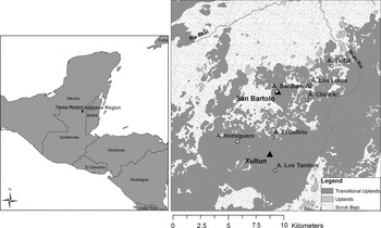
Interestingly, only one aguada (Aguada San Bartolo) occurs in the urban heart (city-center) of San Bartolo, whereas six aguadas are known to exist in the sprawling urban zone of Xultun. The aguadas reported in this article are situated in either the urban settlement zone or hinterlands (rural areas) of the two centers. They are locally known as Aguada Los Loros (16 Q 248318 1942780), Aguada Chintiko (16 Q 247949 1941025), Aguada Delirio (16 Q 243681 1936336) and Aguada Los Tambos (16 Q 244037 1932227) (Figure 1). Earlier investigations conducted at Aguada San Bartolo, Aguada Tintal, and Aguada Hormiguero are briefly summarized later in this article.
Map of the study area.

The study aguadas Los Loros and Chintiko are located in the hinterlands of San Bartolo. In comparison to urban San Bartolo, the settlement density around these aguadas appears much less dense. Aguada Los Loros is situated 3.6 km northeast of San Bartolo on the border of a small upland bajo. Aguada Chintiko is found in a rural upland location with small bajos nearby, 3.2 km southeast of San Bartolo. Aguada Delirio is located within the urban settlement zone 2 km to the north of the Xultun site center. This aguada gets its name from chicleros (gum tappers) who become ‘delirious’ when they find the aguada dry. Lastly, Aguada Los Tambos is situated 2.2 km south of Xultun within the site's sprawling urban settlement zone (Dunning et al. Reference Dunning, Akpinar, Carr, Griffin, Jones, Lentz, Miller, Prater, Urquizú and Saturno2007).
METHODOLOGY
As a part of the archaeological and paleoenvironmental investigation of the aguadas, we retrieved sediment cores from the interior of the aguadas. Also, excavations were performed to further clarify their function and to acquire soil samples for further analysis. We obtained accelerator mass spectrometer (AMS) dates to establish sediment core chronologies and analyzed pollen from core samples. We also examined sediment texture and chemistry, organic content, x-ray diffraction (XRD) and scanning electron microscopy/energy dispersive spectroscopy (SEM/EDS) images, and micro and macro paleobotanical remains from core and soil samples.
We extracted sediment cores from Aguada Los Tambos in 2005 and from Aguadas Los Loros and Chintiko during the 2007 season with a modified Livingstone Piston Corer. Aguada Delirio was not cored because there was a large quantity of chert (an apparent mix of human and natural deposition) on the aguada floor making it impossible to penetrate. The sediment within the bottoms of the other aguadas was extremely soft except for extremely dense basal clay. Hence, the sediments were severely compressed during the coring process and extrusion.
The core from Aguada Los Tambos was initially about 110 cm long, compressing to 41 cm; carbon was extracted at 20 cm and pollen examined from samples at 15 and 25 cm. The core from Los Loros was about 70 cm long but compressed to 22 cm after coring and extrusion with pollen samples taken from 0, 5, 10, 15, and 20 cm. One sample was also taken from the Los Loros core at the 23 cm point (coring boot sample) and another at about 12.5 cm for radiocarbon dating. The samples consisted of microscopic charcoal and amorphous soot as well as sedimentary organic matter derived from leafy and woody material. The core from Aguada Chintiko was about 85 cm long and compressed to 36 cm after extrusion; we analyzed six samples from 5, 10, 15, 25, 30 and 35 cm for pollen; with a sample for carbon dating taken at 31 cm (organic matter with microscopic charcoal and soot). Carbon samples were sent to Beta Analytic Inc. for AMS dating. Pollen was analyzed in the Pollen Laboratory of the Department of Anthropology of Washington State University by John G. Jones.
Recognizing that microfossils could be poorly preserved in the samples, a conservative extraction technique was used for the pollen analysis. After adding Lycopodium spp. spores to each sample, carbonates were removed with 10% hydrochloric acid silicates with 50% hydrofluoric acid and humates with 2–5% potassium hydroxide (KOH). An acetolysis procedure (Erdtman Reference Erdtman1960) eliminated unwanted organics; pollen and charcoal were isolated from the remaining minerals with heavy density separation using zinc chloride (Sp.G. 2.00). Pollen identification took place on a Jenaval compound stereomicroscope at 400–1250 × magnification and identifications were confirmed by using the Pollen Labaratory's extensive reference collection (minimum 200-grain counts for each sample).
We also opened eleven excavation units of 1 × 1.5 to 2 m in extent and with varying depths for archaeological and additional environmental analyses. We took soil and flotation samples from selected units for basic soil characterization, texture, chemistry and organic content, SEM/EDS, XRD analysis, and identification of micro and macro remains. Soil characterization, texture and SEM/EDS, XRD analysis, in addition to identification of micro and macro remains, were completed in laboratories of University of Cincinnati's Biology, Engineering and Geology Departments.
We sent soil samples for Mehlich 3 extraction and ICP determination of Phosphorus (P), Potassium (K), Magnesium (Mg), and Calcium (Ca), analysis of organic matter content (LOI), and pH levels to the Spectrum Analytic Inc. laboratory in Ohio. We also took samples for soil texture analysis from chosen excavation units to determine sediment sizes larger than 250 µm, measuring dry-weight of the samples after removing moisture from the samples in a laboratory oven. Calcium carbonate nodules found in Aguada Los Tambos excavation unit soils were analyzed for structure and chemical composition using XRD and SEM/EDS to determine their origin.
We floated the soil samples from the aguada excavations for micro and macro plant remains using a field flotation device designed and set up by our team next to Ixcan Río. After the samples were air dried, they were sieved with soil sieve numbers 10 to 30 (U.S.A. Standard Sieve Series, .6–2 mm mesh size). The samples were further examined with light microscopy for preliminary identification. The identified seeds were then photographed using a scanning electron microscope (SEM) or a light microscope with a digital camera attached.
Lastly, we estimated the water storage capacity for the aguadas from the modified elliptical cone volume formula adopted from Brewer (Reference Brewer2007):

Where H, ∏, L, W defined as:

RESULTS
Aguada Los Loros
Aguada Los Loros is an irregularly shaped aguada with approximate dimensions of 30 × 40 m. In April 2007, it held approximately 1 m of water. We also observed berms around the aguada, which is an indication that the aguada was modified and most likely dredged to increase its volume by increasing or maintaining tank depth and berm height. During its use, we believe Aguada Los Loros had close to approximately 3 m in water depth, accounting also for nearly 1 m of accumulated sediment in its floor and another 1 m when its berms were intact. When we used the volume formula for Los Loros to estimate its full capacity, we found the aguada to be capable of holding roughly 1414 m3 or about 373,539 gallons of water.
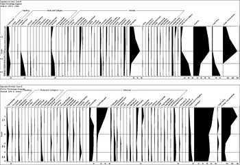
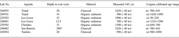
The sediment core taken from Aguada Los Loros revealed a basal measured radiocarbon date of 1890 ± 40 b.p. or 30–230 cal a.d. (p = .95, 2σ) at 23 cm. A second AMS date of 780 ± 40 b.p. or 1210–1290 cal a.d. (p = .95, 2σ) was determined for a carbon sample at a depth of 12.5 cm on the sediment core (Table 2). We observed mottling in the core between 8 cm and 23 cm indicative of at least episodic desiccation. Based on these dates and pollen evidence (discussed below), we believe the maintenance of this aguada ended after the Late or Terminal Classic period (ca. a.d. 900), but it remained a largely dependable water source. The core is divided into zones for detailed examination below (Figure 2).
Pollen frequency diagrams from Aguadas Chintiko and Los Loros.

AMS dating results

* Pit excavation
Zone 3
Zone 3 shows the nature of vegetation surrounding the aguada sometime after a.d. 30–230. Pollen in Zone 3 is characterized by higher percentages of herbs and cultigens and lower percentages of arboreal taxa, indicative of considerable human disturbance. A single Zea mays (maize) pollen grain and arboreal pollen types pointing to possible economic tree species such as Arecaceae (Palm Family), Coccoloba sp. (Boob Tree, edible fruit and leaves used for cooking), Sapotaceae (Sapote Family) and Spondias sp.(hog plum) are also present. Additionally in Zone 3, disturbance taxa such as Asteraceae, Borreria, Chenopodiaceae, and Amaranthus (Cheno-Am) and Solanaceae are present, corroborating our finding of human land clearance and forest modification in the vicinity of the aguada.
Zone 2
The higher levels of disturbance taxa in Zone 3 peak at the outset of Zone 2, then decrease steadily in conjunction with an increase in tropical forest taxa from the beginning of Zone 2 toward Zone 1. These changes can be interpreted as a decline in human activity in the area. In the beginning of Zone 2, we again see a single grain of Zea mays pollen in addition to a single grain of Gossypium (cotton) that is accompanied by the disturbance indicators, Cheno-Am, Asteraceae, and the secondary forest taxon of Borreria. The marginal forest taxon Cecropia also appears. Arboreal pollen of Myrtaceae increases rapidly to up to 50% of the total pollen sum toward the end of Zone 2, where we also obtained a calibrated date range of a.d. 1210–1290 at the 12.5 cm point of the core. High forest taxon of Moraceae further begins to increase, but not as dramatically as Myrtaceae. Zone 2 marks the transition between Maya occupation and the abandonment of the area.
Zone 1
The boundary between Zone 2 and Zone 1 displays a sharp break in the pollen diagram. Zone 1 represents a post-Maya reforestation period with a drop to near zero values in disturbance indicators.
Excavations
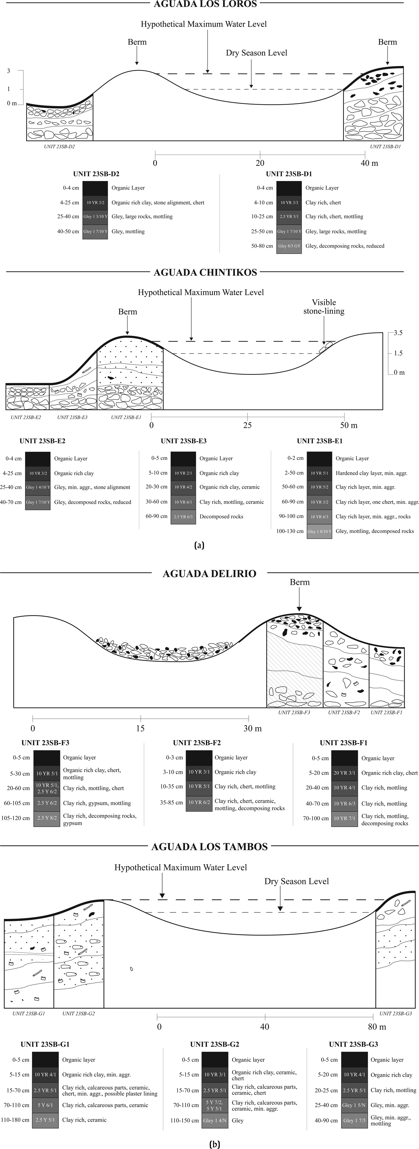
During our 2007 field work, we did not observe any modern settlements near Aguada Los Loros. Yet, based on the litter around it, we believe the aguada was frequented by chicleros and other sporadic visitors. We opened our first unit, 23SB-D1, on the sloping surface in the eastern edge of Aguada Los Loros. We unearthed chert lithic debitage between 10 and 25 cm above a gleyed clay layer with orange mottling among much larger rocks (Figure 3a).
Excavation drawings. (a) Aguadas Los Loros and Chintiko, and (b) Aguadas Delirio and Los Tambos.
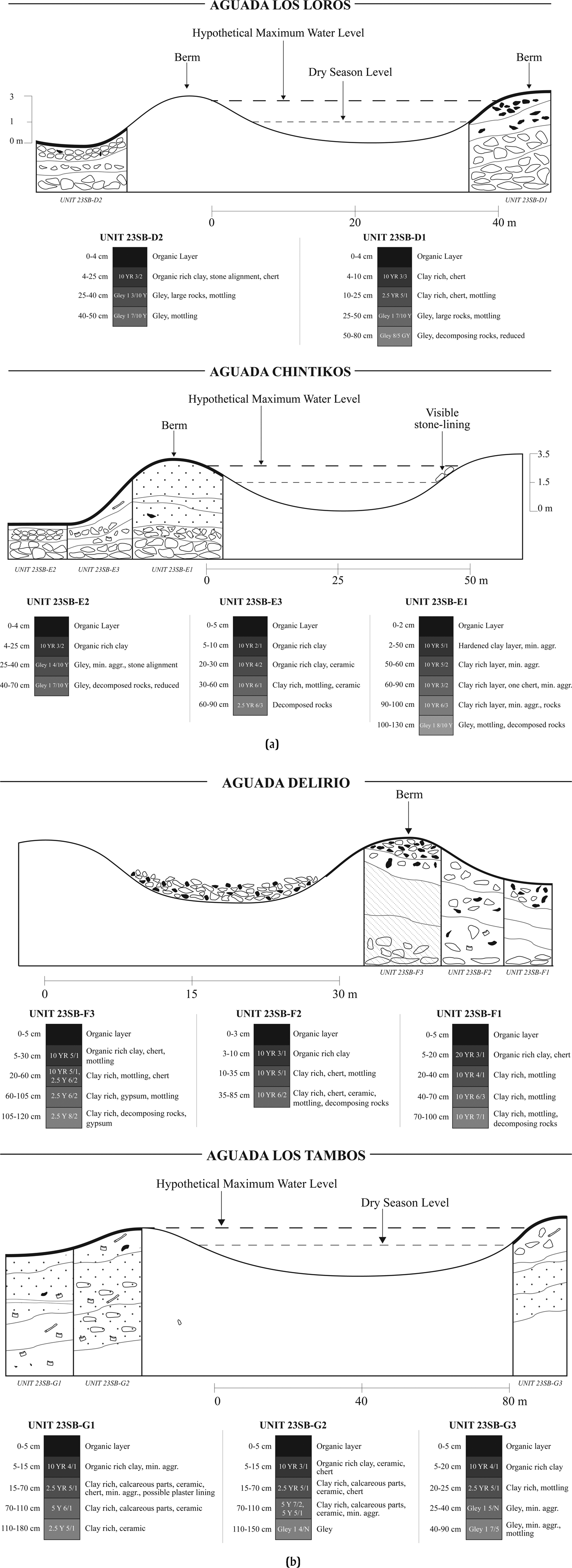
We opened a second excavation unit, 23SB-D2, on the western side of the aguada, in a depression next to a well-defined berm, but we had to stop the unit at 50 cm below the surface due to in-flowing water. The form and position of this depression and berm suggested that it may have served as a siltation tank at the end of a low gradient drainage leading into the aguada. At a depth of between 4 and 25 cm, we identified several chert fragments found among limestone rocks placed at somewhat regular intervals. In the levels below, we found additional large limestone rocks of various sizes with several pieces of chert debitage. Overall, the levels below the 25 cm depth initially displayed orange mottling in a reduced dark gray gley layer and continuing into the light gray gleyed clay that began at a depth of 40 cm. Below the 40 cm depth we did not find any other cultural material, only smaller rocks and additional orange mottling within the clay matrix.
The apparent mottling/oxidation seen between the reduced gley soil layers in both the 23SBD1 and 23SBD2 units and in the sediment core that corresponds to a calibrated date range of a.d. 30–230 potentially points to a climatic drying episode experienced in the region towards the end of the Late Preclassic period, a phenomenon documented in other parts of the Maya Lowlands (Dunning et al. Reference Dunning, Wahl, Beach, Jones, Luzzadder-Beach, McCormick and Iannone2012; Wahl et al. Reference Wahl, Byrne, Schreiner and Hansen2006).
The arrangement of the large boulders connected to the berm near unit 23SBD2 may signify an effort to control water movement in and out of the aguada to allow for filtering in the silting tank. One diagnostic characteristic noted for silting tanks is the presence of coarser textured sediments within the bottom of the tank (Chmilar Reference Chmilar2005; Scarborough Reference Scarborough1994). When sediment texture analysis was done on samples from a depth of between 25 and 40 cm, 6% of the dry-weight was shown to consist of grain sizes larger than 250 µm. For comparative purposes, control samples from similar excavation unit levels with various sizes of rocks in Aguadas Delirio and Los Tambos were measured for grain sizes larger than 250 µm. The results were as follows: Aguada Chintiko 23SBE2 at 4–25 cm (3.7%); Aguadas Delirio 23SBF2 at 10–35 cm (3.3%); and Aguada Los Tambos 23SBG2 at 70–110 cm (1.3%). Thus, while the overall percentage of coarse grains in the Los Loros tank feature is not high, it is considerably higher than those found in contexts adjacent to other aguadas (noting also that the region is a very sand-poor environment as a whole), offering support to the identification of this feature as a silting tank.
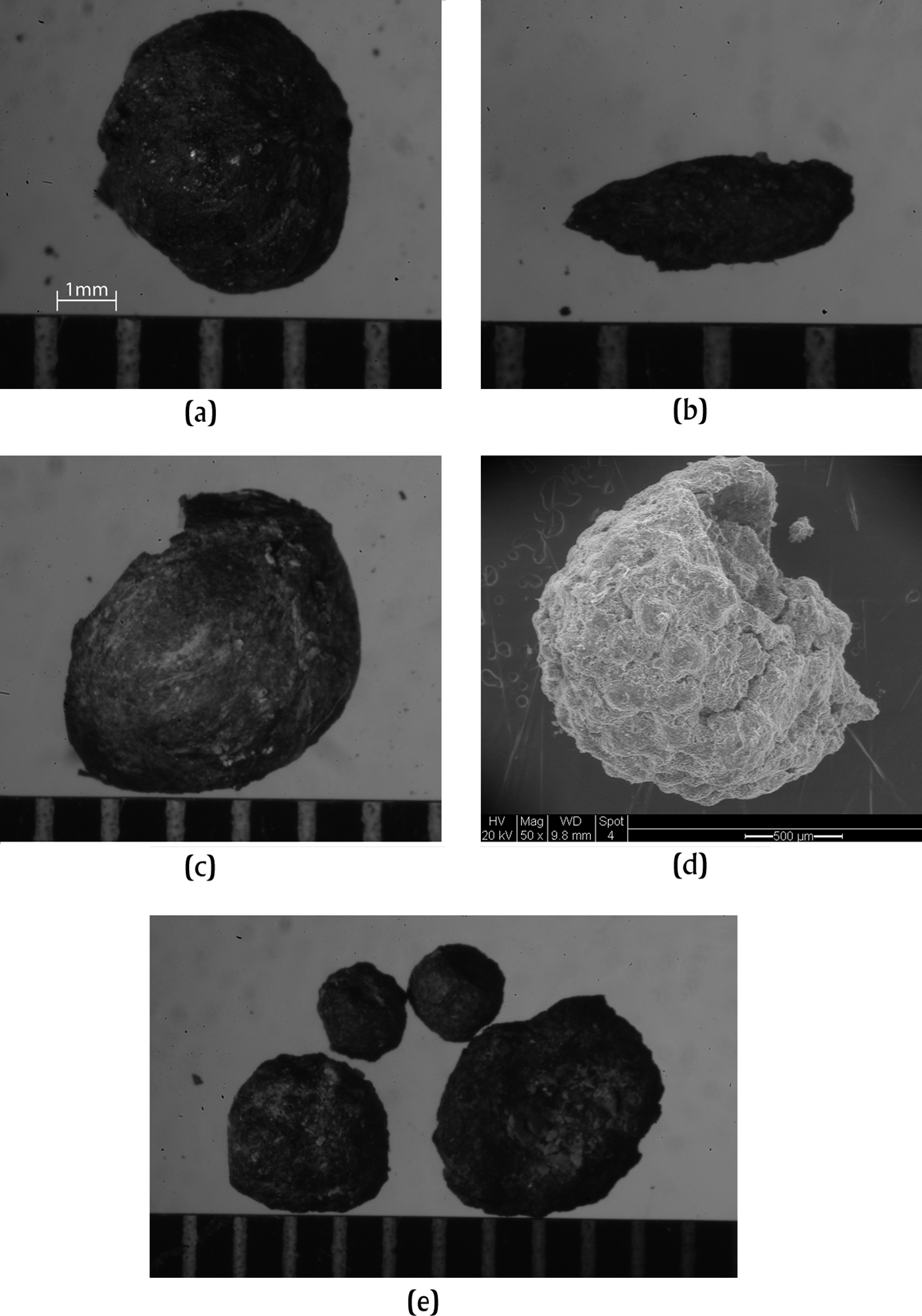
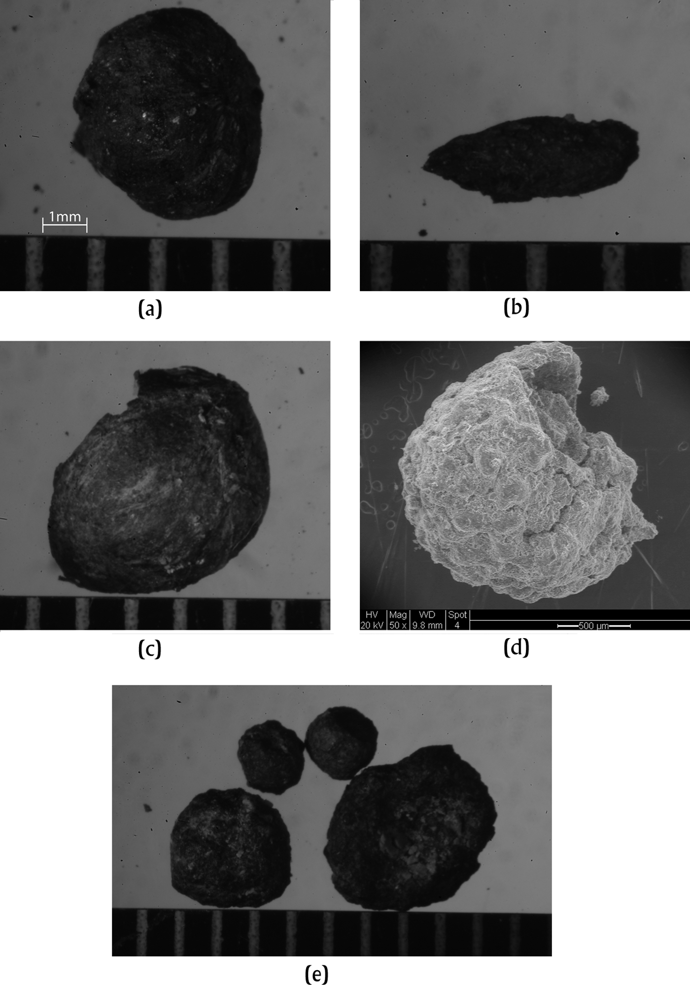
The soil samples from 23SBD2 were also analyzed for micro and macro plant evidence. We were able to identify seeds of Vitaceae, Poaceae, Lauraceae and Cleome spinosa (Figure 4). Particularly, the identification of Cleome spinosa supports the idea that this unit may have acted as a silting tank, based on the described habitat of the species as a “spiny herb of open slopes, sandy thickets and found along streams” (Lentz and Dickau Reference Lentz and Dickau2005). Additionally, the evidence of Poaceae indicates grassy vegetation around the aguada, which is a common disturbance indicator.
Images of carbonized remains and mineral aggregates: (a) Vitaceae; (b) Poaceae; (c) Lauraceae; (d) Cleome spinosa; (e) Mineral aggregates.
Aguada Chintiko
Aguada Chintiko is approximately 50 m in diameter and has a roughly circular shape. The aguada held approximately 1.5 m of water in April 2007. We believe Aguada Chintiko originally held water to a height of about 3.5 m, considering an approximate 1 m of accumulated sediment from our sediment core, and also roughly 1 m for the berms when they were intact. When we used the volume formula for Aguada Chintiko, we found the aguada to be capable of holding approximately 3,436 m3 or about 907,695 gallons of water. Visual inspection around the aguada also revealed that a stone lining may have been used on the interior slope of the berm. However, no dates were determined for this construction, nor could the interior slope be excavated because of the standing water.
The sediment core taken from Aguada Chintiko produced an AMS date of 1300 ± 40 b.p. or 650–780 cal a.d. (p = .95, 2σ) from a sample at the 31 cm point (Table 2). The late date is likely an indication of the dredging of sediments from the aguada at some point during its use considering the much denser occupation of the San Bartolo area during the Preclassic period (Garrison Reference Garrison2007). On the other hand, the carbon date when coupled with the pollen evidence further presents verification of human presence in the Late Classic period around San Bartolo, as also suggested by Garrison's survey of the area (2007). The pollen in the core is divided into three zones as outlined below (Figure 2).
Zone 3
Zone 3 represents the time period before a.d. 650–780 with clear evidence of human disturbance around Aguada Chintiko. In this zone, herbs and cultigens account for about 20% of the total pollen count, though there is no Zea mays pollen. However, this absence may not be revealing considering that Zea mays is often poorly represented in pollen assemblages. Moreover, Gossypium (cotton) pollen was found along with other possible economically valuable species such as Arecaceae, Coccoloba spp. and Sapotaceae. In addition, we found Cyperaceae and Nymphaea pollen that both diminish upward toward Zone 2. The decline of these two aquatic species may be interpreted as a clearing of the aguada or a change in local hydrology (Wahl et al. Reference Wahl, Schreiner, Byrne and Hansen2007). Furthermore, in Zone 3, there is the appearance, then disappearance, of Borreria, a weed common in cultivated areas (Lohse Reference Lohse, Valdez and Lohse2004). Lastly, pollen of Pinus and Quercus, which are extra-local species, show some of their highest levels throughout Zone 3. Their presence is a likely sign of forest clearance around the aguada allowing for the capture of pollen traveling from greater distances (Mueller et al. Reference Mueller, Islebe, Hillesheim, Grsesik, Anselmetti, Ariztegui, Brenner, Curtis, Hodell and Venz2009). Land clearance is also indicated by the high count of disturbance species such as Asteraceae, Bursera, Cecropia and Poaceae pollen.
Zone 2
In Zone 2, while certain aquatics increase slightly, herbs and cultigens begin to show a decline, and the arboreal species gradually reemerge. Aquatics such as Cyperaceae increase close to 10% and Nymphaea re-emerges at the end of Zone 2, after a disappearance from the middle of Zone 3. Bursera, an abundant upland tree in the secondary forests (Wahl et al. Reference Wahl, Schreiner, Byrne and Hansen2007), shows an increasing trend from the beginning of Zone 3 until the end of Zone 2. The tree diminishes gradually toward Zone 1.
Zone 1
Overall, Zone 1 shows a dominance of the tropical forest taxa of Moraceae and Combretaceae and a decline in herbs and cultigens. This zone clearly marks the end of the human disturbance and a return of tropical forest taxa in the post-Maya period.
Excavations
We opened three excavation units in Aguada Chintiko: 23SBE1, 23SBE2 and 23SBE3 (Figure 3a). We began our excavations initially on a berm next to the aguada in unit 23SBE1, a 1 × 1 m and 1.3 m deep pit. Soil texture is dominated by clay with a slight color variation throughout the profile, but with orange mottling starting at 1.1 m. The lack of variation in the unit's sediment profile likely indicates that the berm was largely created with the sediments dredged from the aguada. In addition, what we initially thought were carbonized seeds recovered from a depth of 1.1 m through a flotation process, were determined to be tiny aggregates of manganese oxide during our laboratory analysis (Figure 4e). Easily mistaken for carbonized seeds, these aggregates are common products of weathering in soils, as manganese and iron tend to form oxides where there has been extensive chemical weathering (Essington Reference Essington2003).
Unit 23SBE2 was opened in a flat, lower area immediately outside of the aguada berm to the east of unit 23SBE1. The 1 × 1 m pit reached a 70 cm depth. We found a concentration of 6–8 cm long limestone rocks between 4 and 40 cm below the surface. At a depth of 40 cm, a number of large rocks were uncovered along with further evidence of orange mottling before the regolith layer at 70 cm. Overall, we found unit 23SBE2 to be very similar to unit 23SBD2 from the Aguada Los Loros, with both units exhibiting regularly aligned limestone rocks adjacent to clay berms that probably acted as footing walls.
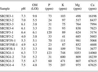
Unit 23SBE3 was excavated on another flat surface 3 m away from the edge of the aguada. Between depths of 15 and 35 cm, we unearthed a number of limestone rocks of varying sizes. However, the distribution of the rocks seemed random compared to those in units 23SBD2 and 23SBE2. We recovered two pottery sherds, at depths of 20 cm and 36 cm, respectively, which could not be dated due to extensive weathering. There was only a thick layer of gleyed clay with orange mottling between 40 and 60 cm (with no further cultural material), at which point we reached weathered bedrock. Samples from unit 23SBE3 were subjected to a range of soil chemical analyses due to our observations of variation in the soil characteristics in the profile. In this mostly pH neutral unit, we found an increase in Mg with unit depth, reflecting chelation (e.g., mineral aggregates), while the Ca decreased in parallel. We did not find P levels high enough to suggest pronounced human input to 23SBE3 sediments (Table 3).
Soil analysis results from Aguadas Chintiko, Delirio, and Los Tambos

Aguada Delirio
Aguada Delirio is situated within the urban zone of the city of Xultun and has a somewhat oval shape with dimensions of about 20 × 30 m. The aguada could not be cored in 2007 due to an abundance of chert on the aguada's floor. Lacking information on sediment depth also made it impossible to accurately estimate the volume of Aguada Delirio. With no core, we were also not able to recover pollen from this aguada.
Excavations
Three excavation units opened around the aguada uncovered evidence of extensive chert processing (Figure 3b). Two of the excavation units were placed roughly 10 m away from the aguada on lower areas next to the berm on the eastern side of the aguada: 23SBF1 and 23SBF2. The third unit, 23SBF3, was opened on the berm on the same side of the aguada.
In 23SBF1, we found an abundance of worked chert and numerous pieces of rocks. Sediments in the unit, similar to other units in Aguadas Los Loros and Chintiko, exhibited mottling starting 20 cm below the surface until a final depth of 1 m. Unit 23SBF2 showed more far-reaching mottling starting at a depth of 10 cm until 85 cm, including lithic debitage, several large rocks and broken pieces of badly weathered ceramic. Sherds at a depth of 40 to 50 cm and chert debitage at different levels from 10 cm until 85 cm in unit 23SBF2 suggest that this aguada was in use for a considerable period of time.
The third unit 23SBF3 was opened on the berm itself close to excavation 23SBF2. The berm exposed in unit 23SBF3 was likely built from material dredged from the aguada, suggested by a lack of variation in soil throughout its profile. The unit produced some lithic debitage but no additional cultural material. Starting at a depth of 60 cm, and more abundantly at 120 cm, we encountered gypsum crystals, a common precipitate in wetting and drying soils in the Maya Lowlands. Interestingly, later lab analysis showed variability in basic soil chemistry within the pit. A high level of P occurred in unit 23SBF3, a clear indication of a large, probably anthropogenic organic input in the berm of the Aguada Delirio (Table 3).
Survey and excavations carried out along an arroyo near Aguada Delirio uncovered chert nodules and rocky debris used for the construction of a diversion weir (Dunning et al. Reference Dunning, Akpinar, Carr, Griffin, Jones, Lentz, Miller, Prater, Urquizú and Saturno2007). Clearly, large quantities of chert were being processed in this area of Xultun.
Aguada Los Tambos
Aguada Los Tambos lies along the southern margin of urban Xultun. This aguada is large and irregularly shaped with an approximate diameter of 80 m. It is reported to hold water year-round. When the aguada was cored in March 2005, the deeper parts held up to 2 m of water, and the longer of two sediment cores taken from the aguada reached a depth of 1.10 m. If we consider approximately 1 m for sediment accumulation and another 1 m for the water holding capacity with intact berms, in addition to the present day water level, we estimate a total water height of 4 m when Aguada Los Tambos was at its full capacity. This would result in an approximate maximum volume of 10,053 m3 or 2,655,722 gallons of water for the aguada.
In the sediment core extracted from the aguada in 2005, we observed dark orange/red mottling and gypsum precipitates within dense, light gray clay in the lower section of the core between 22 and 41 cm, an additional sign of past oxidation and drying in the San Bartolo and Xultun region. A carbon sample taken at a point 20 cm into the core produced an AMS date of 990 ± 40 b.p. or cal a.d. 980–1080 (p = .95, 2σ) (Table 2). We find that the oxidation layer several centimeters below the a.d. 980–1080 calibrated date possibly signifies a drying period in the region during the Terminal Classic period (Dunning et al. Reference Dunning, Chmilar, Blevins, Jones, Urquizú and Saturno2005, Reference Dunning, Wahl, Beach, Jones, Luzzadder-Beach, McCormick and Iannone2012; Garrison and Dunning Reference Garrison and Dunning2009). Above 22 cm, core sediments changed abruptly into organic muck.
Similar to Aguada Chintiko, the late AMS date from Aguada Los Tambos suggests dredging of the aguada during its use, which also led to the removal of pollen proxy data corresponding to the Maya settlement period. Pollen was not preserved in the core below 20 cm; above the 20 cm point pollen identified in the core belonged to the post-Maya reforestation period. Inscriptions on the dynastic stelae at Xultun indicate that it was one of the last Maya centers to be abandoned in the Terminal Classic period—the last stela erected at Xultun dates to a.d. 889, a date after the collapse of Tikal and other major sites of the region (Garrison Reference Garrison2007).
Excavations
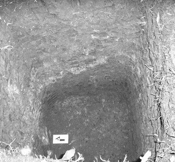
During the 2007 field season, we opened three excavation units around the aguada: 23SBG1, 23SBG2 and 23SBG3 (Figure 3b). The first excavation unit, 23SBG1 was located in a depression 10 m to the east of the aguada. Based on our observations, this depression was likely a part of the aguada, even though there was no water due to the dry season. In this unit we observed cultural material such as pot sherds from the Classic period, worked chert and material that resembled plaster or stucco between 50 cm and 70 cm below the surface. A small portion of apparent plaster lining was also preserved in the eastern wall of this unit (Figure 5). Additionally we continued to find pottery sherds and carbon specks until 1.6 m below the surface. Later analysis of the recovered sherds by the San Bartolo Project ceramicist identified exclusively Preclassic ceramics below the apparent plaster-lining level (Rivera Castillo Reference Rivera Castillo, Urquizú and Saturno2007). Encountering small, round formations that looked like carbonized seeds between 15 cm and 70 cm, we also took flotation samples. However, what we believed to be carbonized seeds were again determined to be metal oxide nodules during our laboratory analysis.
Evidence of plaster-lining in Op 23SBG1, Aguada Los Tambos.

In unit 23SBG2, located 15 m north of the aguada on a raised surface, we unearthed cultural material such as pottery sherds, chert and, again, plaster-like material that was diffused vertically in an irregular manner, starting at 20 cm all the way down to 1.1 m. The diffusion of the calcareous material throughout the profile likely resulted from severe argilliturbation since the clay sediments have been subjected to a dry/wet climate cycle over time and pedogenic features such as slickensides created by clay heaving were prevalent. Additionally, San Bartolo Project archaeologists found the sherds recovered from unit 23SBG2 to range from Preclassic to Classic period types, an indication of the long use of Aguada Los Tambos, but with little surviving vertical stratigraphy caused by considerable post-depositional movement due to argilliturbation. In unit 23SBG3, located inside a dry interior area in the western part of the aguada, we similarly found pockets of the plaster-like calcareous material interspersed within the gleyed clay soil, but did not find any cultural material; metal oxide nodules and orange mottling were pronounced within the gleyed clay sediments.
In all of the excavation units in Aguada Los Tambos, we observed high amounts of calcareous material. Chemical analysis of soil samples confirmed the presence of much larger amounts of Ca in this aguada's sediments in comparison to the other aguadas that were tested. We also found elevated P, K, and Mg levels near the surface in unit 23SBG1, indicative of human activity (Table 3).
Identification of Calcareous Material in Aguada Los Tambos
The prima facie examples of plaster-like material made us question whether there had been a plaster-lining inside Aguada Los Tambos. We were particularly surprised to see possible evidence of plaster-lining inside Aguada Los Tambos given its large size and also its distance from the city-center. Most known examples of plastered reservoirs in the Maya Lowlands occur in sitecenters. In order to determine the origin of the plaster-like calcareous material, we employed XRD and SEM/EDS techniques to the samples from Aguada Los Tambos. We also compared the samples to a known plaster sample from the intact Middle Preclassic period plaster-lining in Aguada San Bartolo.
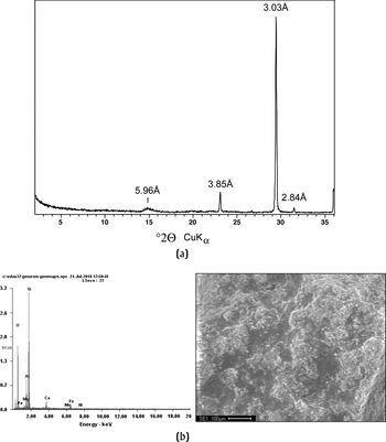
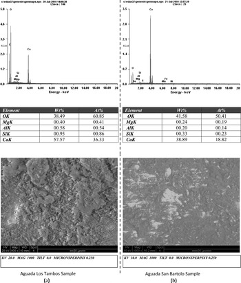
XRD and SEM/EDS testing showed that the samples from Aguada Los Tambos were largely composed of CaCO3 (calcium carbonate) as well as Si (silicon) aggregates, small amounts of Mg-calcite and a few specks of MnO (Figure 6). The powder x-ray diffraction scan of an Aguada Los Tambos sample clearly showed definitive calcite (CaCO3) peaks at 3.85 angstroms, 3.03 angstroms and 2.84 angstroms. Also, the inclusion of Si aggregates in the plaster identified through SEM/EDS reminded us that the Maya perhaps included quartz (SiO2) sand or volcanic ash within the plaster. Additionally, comparative SEM/EDS analysis of the samples from Aguadas Los Tambos and from Aguada San Bartolo demonstrated very similar characteristics between the materials from the two aguadas. We found that while the intensity scale (Y-axis) varies slightly between the two, the high calcium peak for the Aguada Los Tambos samples was not very different from the peak for the Aguada San Bartolo sample (Figure 7).
XRD and SEM/EDS analysis of calcareous material from Aguada Los Tambos.

Comparative SEM/EDS analysis between Aguadas of Los Tambos and San Bartolo.

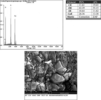
In general, calcium carbonate (CaCO3) is the principal component used in making plaster (Villaseñor Alonso Reference Villaseñor Alonso2009). However, the calcium carbonate found in our samples could represent calcium carbonate rich material that naturally exists ubiquitously in the Maya environment. One of the inherent problems in distinguishing human-made lime from naturally occurring calcium carbonate rests in the fact that slaked lime absorbs atmospheric carbon dioxide over time and becomes calcium carbonate again (Wernecke Reference Wernecke2008). In light of this, we had to also consider that the layer might be the result of biogenic marl formation through the precipitation of calcium carbonate by periphyton/algae in a wetland habitat, possibly including mollusk shells (for example, the Solleiro-Rebolledo et al. [Reference Solleiro-Rebolledo, Cabadas-Baez, Pi, Gonzalez, Fedick, Chmilar and Leonard2011] study in Quintana Roo). We tested this hypothesis by analyzing samples of a biogenic marl layer from a wetland site on Marie-Galante, a limestone island in the Caribbean (where Dunning and Jones conducted field work in 2008) and compared it to the Aguada Los Tambos CaCO3 samples and the known plaster sample from Aguada San Bartolo. The SEM/EDS analysis of the biogenic marl sample from the Marie-Galante wetland revealed that this sample had high amounts of sulfide, not present in either Aguada Los Tambos or Aguada San Bartolo samples (Figure 8). The Aguada Los Tambos samples also did not display evidence of weathered mollusk shells, another possible source of CaCO3. Additional microscopic and laboratory analysis of the samples from Aguada San Bartolo and Aguada Los Tambos further showed that the sample sediments were lacking in pollen, organic, and algal materials and, therefore, inconsistent with biogenically-produced carbonates.
SEM/EDS analysis of a biogenic marl from a wetland on the Caribbean island of Marie-Galante.

In the end, the very similar characteristics of the samples from Aguada Los Tambos in comparison to the sample from the Aguada San Bartolo lining (i.e., that of a known Maya plaster), dissimilarities to biogenic marl, evidence of intact plaster-lining in a small area of unit 23SBG1 and the occurrence of the CaCO3 pockets combined with different minerals such as Si aggregates throughout the stratigraphy lead us to believe that the samples from Aguada Los Tambos were not natural CaCO3, but the weathered and broken (by argilliturbation) remains of a human-made plaster lining. Additionally, despite being subjected to similar environmental conditions, none of the other aguadas in the San Bartolo-Xultun intersite region displayed a CaCO3 layer in their stratigraphy.
To date, the Aguada San Bartolo (discussed further below) is the only other aguada known at the study area with a plaster lining. In recent excavations at the Peten site of Tikal and the Puuc region site of Xcoch, Dunning has observed that plaster-lining were used in some site-center reservoirs whereas clay lining was more typical for aguadas on the urban fringe. We know from archaeological studies and surveys in the region that plaster was used and produced by the Maya around San Bartolo and Xultun (Dunning et al. Reference Dunning, Chmilar, Blevins, Jones, Urquizú and Saturno2005; Garrison Reference Garrison2007). Garrison (Reference Garrison2007) mentions that the decrease of plaster thickness in floors seen in San Bartolo was possibly due to deforestation and the necessity of burning large amounts of wood to make Maya plaster. Deforestation and declining wood supplies were also a likely problem around Xultun.
Overall, the evidence of plaster-lining associated with a rather large aguada away from a site-center is surprising. It appears that at least a section of Aguada Los Tambos (or a depression connected to the aguada) was plastered to create a drinking water collection point for the inhabitants of suburban Xultun, an investment which might have been prompted by episodes of climatic drying. Ceramic evidence further supports our findings showing that the Xultun inhabitants plastered parts of Aguada Los Tambos sometime no earlier than late in the Late Preclassic period.
Aguada San Bartolo, Aguada Tintal, and Aguada Hormiguero
Archaeological and paleoenvironmental investigations have also been carried out at three other aguadas in the San Bartolo-Xultun region: Aguada San Bartolo (in the San Bartolo site center), Aguada Tintal (in a rural settlement area several kilometers northeast of San Bartolo), and Aguada Hormiguero (on the northwestern urban fringe of Xultun). These investigations have been reported on elsewhere, but are summarized here.
Aguada San Bartolo is roughly circular with a diameter of approximately 18 m and situated immediately adjacent to the monumental architecture of the Ventanas Group. In 2005, a 1 × 1.5 m unit was excavated in the center of the aguada reaching a depth of 3.3 m (Dunning et al. Reference Dunning, Chmilar, Blevins, Jones, Urquizú and Saturno2005; Garrison and Dunning Reference Garrison and Dunning2009). The excavation revealed that the aguada likely originated as a stone quarry, which was sealed with a thick plaster lining; AMS dating of charcoal within the plaster at 780–410 cal b.c. (p = .95, 2σ) indicates that the creation of this reservoir dates to the Middle Preclassic period (Table 2), contemporaneous with the first monumental architecture known at the site (Saturno et al. Reference Saturno, Stuart and Beltran2006). The aguada filled with a large volume of sediment later in the Preclassic period and after site abandonment around a.d. 150, but was partly dredged of sediment and re-lined with plaster around a.d. 700 when the site was briefly reoccupied. Sediments in the aguada did not preserve pollen.
Aguada Tintal is roughly circular in shape with a diameter of about 30 m and is surrounded by a low berm. In 2005, two sediment cores were extracted from near the center of the aguada (Dunning et al. Reference Dunning, Chmilar, Blevins, Jones, Urquizú and Saturno2005). The longer core reached a depth of 80 cm, but compressed to 24 cm in length and was subsampled and analyzed. The core contained three zones (Dunning et al. Reference Dunning, Wahl, Beach, Jones, Luzzadder-Beach, McCormick and Iannone2012). The lowest level corresponded with the Maya Middle Preclassic period and bore pollen including maize, cotton, and manioc (Manihot esculentum). The middle zone was undated oxidized and gypsic clay. The uppermost zone was organic sediments bearing high forest pollen and radiocarbon dated to the Postclassic period after regional abandonment. We interpreted the oxized zone as most likely corresponding to a severe Late Preclassic period desiccation episode (Dunning et al. Reference Dunning, Wahl, Beach, Jones, Luzzadder-Beach, McCormick and Iannone2012). Classic period sediments appear to have been removed by dredging. Excavation on and near the western berm of the aguada in 2007 revealed a stone retaining wall supporting a clay berm and covering a buried soil dating to the Middle Classic period (ca. 700 b.c.), suggesting that the aguada was constructed at that time (Dunning et al. Reference Dunning, Akpinar, Carr, Griffin, Jones, Lentz, Miller, Prater, Urquizú and Saturno2007). The aguada most likely originated as a chert quarry as evidenced by extensive chert processing deposits in the immediately surrounding areas.
Aguada Hormiguero lies on the northern fringe of urban settlement at Xultun and on the flank of the large Bajo Itz'ul. In 2008, Michael Storozum excavated two 1 × 1 m test pits in the aguada and collected sediment samples that were analyzed by Dunning (Storozum Reference Storozum2009). The excavations revealed that this aguada likely originated as a natural bajo-margin karst depression that was modified by quarrying beginning early in the Preclassic period. The aguada appears to have been in continuous use through the Classic period, including periodic dredging, until its final abandonment in the Terminal Classic period. No pollen was recoverable from the aguada sediments.
DISCUSSION
Investigations of Aguadas Los Loros, Chintiko, Delirio and Los Tambos have revealed that these aguadas served various purposes around the ancient cities of San Bartolo and Xultun. Our investigations not only suggest that the aguadas around San Bartolo and Xultun might have been used in activities related to agriculture (based on cultigen evidence) and chert processing, but also that these aguadas represent evidence of ancient Maya low-technology engineering solutions to help store water in a seasonally water-poor area that included the use of berms, silting tanks, stone pavements, and plaster lining.
In a region with no lakes, aguadas are particularly useful for archaeologists because of the amount of paleoenvironmental data they preserve, including ancient pollen, charcoal, and sedimentary evidence of past climatic drying. We also observed the ancient Maya's habit of dredging aguadas to increase or maintain their capacity, which, from the perspective of modern investigators, had the unfortunate effect of removing paleoenvironmental data.
We found that the pollen sequences gathered from the aguadas mostly reflected the local vegetation. As small bodies of water, aguadas capture the localized pollen of less-common plant species whose pollen does not travel far (e.g., Zea mays and Manihot esculentum). As a result, the pollen extracted from aguadas could also prove valuable in revealing the function of aguadas within ancient Maya agriculture. In Aguadas Los Loros, Chintiko and Tintal the pollen of cotton, manioc and maize (single pollen grains) were extracted alongside indicators of human disturbance and forest clearance. We are not sure whether or not irrigation was practiced around the aguadas or the precise location of surrounding fields. However, we know that the pollen of maize does not travel far, as it was shown that pollen concentration 60 m from a Zea mays plant in a downwind area averaged 1% of those settled at 1 m (see Luna et al. Reference Luna, Figueroa, Baltazar, Gomez, Townsend and Schoper2001). Corroborating our observation on the possible agricultural significance of aguadas comes from another pollen profile from Aguada Elusiva close to the site of La Milpa, Belize. Zea Mays pollen in the Aguada Elusiva pollen profile reached a significant 10% level of the pollen count during the ancient Maya's use of the aguada (Weiss-Krejci et al. Reference Weiss-Krejci, Akpinar-Ferrand, Dunning, Brandl, Jones and Lentz2011).
Manioc pollen, such as that found in Aguada Tintal, is considerably rarer because the pollen grains are extremely large and fragile, and as a crop it is propagated by root cuttings typically before flowering. Manioc pollen has also been recovered in the Aguada Ojos de Aguas in northwestern Belize (Dunning et al. Reference Dunning, Jones, Beach, Luzzadder-Beach, Scarborough, Valdez and Dunning2003).
Through the sediment cores and archaeological excavations in all of the aguadas investigated we were also able to detect evidence of climatic drying episodes in the Late Preclassic and Terminal Classic periods in the San Bartolo-Xultun region based on the evidence of oxidation and gypsum precipitation. Our findings support various paleoenvironmental studies in the Maya Lowlands indicating climatic drying intensifying during the later Late Preclassic period between a.d. 125–210, and in the Terminal Classic period between a.d. 800–1000 (e.g., Brenner et al. Reference Brenner, Hodell, Curtis, Rosenmeier, Anselmetti, Ariztegui, Gomez-Pompa, Allen, Fedick and Jimenez-Osornio2003; Curtis et al. Reference Curtis, Brenner, Hodell, Balser, Islebe and Hooghiemstra1998; Hodell et al. Reference Hodell, Brenner, Curtis and Guilderson2001).
Additionally, our archaeological investigations showed that several of the aguadas seem to have originated as quarries. Aguada San Bartolo began as a stone quarry, whereas Aguada Tintal appears to have functioned for a time as a chert mine. Near Xultun, Aguada Delirio similarly showed strong evidence for originating as a chert mine, and this activity may also have contributed to the formation of Aguada Hormiguero. Intriguingly, the emblem glyph used by the Xultun royal dynasty includes the toponym “chert mountain” indicating the importance of this resource at the site (Garrison and Dunning Reference Garrison and Dunning2009). We find that Aguada Delirio and other similar aguadas in the research area may represent a type of aguada that could be characterized by their resource-based use, and also possibly by their creation from stone quarries or chert mines. Further evidence of lithic debitage near aguadas apparently during the period of their use, such as in Aguada Los Loros where there is also evidence of agricultural activity in the immediate vicinity, is indicative of multi-purpose areas.
Furthermore, the discovery of a plaster lining in a section of a large aguada such as Aguada Los Tambos shows that the aguada's water was in all probability intended for, among other uses, drinking by Xultun's urban population. Other evidence that the region's aguadas may have provided potable water is the Nymphaea pollen identified in the Aguada Chintiko core. The presence of Nymphaea is an indication of good water quality since these species are known to grow in clean and still water (Lucero Reference Lucero2002). These species were likely also useful in preventing excess evaporation from aguadas, while reducing organic waste in the aguada water (Davis-Salazar Reference Davis-Salazar2003).
The water volumes calculated for the aguadas provided additional information on their likely contribution to per capita water availability for the residents of the San Bartolo-Xultun area. The current standard of water use per day per person is 64 oz. (.5 gallon) (Brewer Reference Brewer2007). Thus the largest aguada we investigated, Aguada Los Tambos with a volume of 2,655,722 gallons, at full capacity with no evaporation, could provide approximately 14,550 people with their daily water needs for one year, excluding the alleged water needs for agricultural production. Garrison (Reference Garrison2007) calculated an estimated 8,260 population count or 481–513 people/km2 in the San Bartolo-Xultun intersite area (1,652 mounds with a density ranging from 96–103 structures/km2 for a survey universe of 25 km2) by the Late Classic period. Based on the volumes of the investigated aguadas alone, we see that the aguadas of the study area played a vital part in the area's water management systems to support water needs for drinking, household use and, possibly, for agricultural purposes.
Archaeological investigations around San Bartolo and Xultun have confirmed the abandonment of San Bartolo at the end of the Late Preclassic period, and of Xultun in the Terminal Classic period (Garrison Reference Garrison2007). Investigations indicate that the cities of San Bartolo and Xultun had completely different water management strategies. While San Bartolo had only one urban reservoir, Xultun is known to have had at least six (Dunning et al. Reference Dunning, Akpinar and Jones2008). The differences between the two cities in terms of water management are further demonstrated by the plastering of a part of at least one large-sized aguada outside of the site center at Xultun. These dissimilarities may help explain why one city was abandoned at the end of Late Preclassic period and the other one continued to prosper through the Late Classic period, especially in light of episodic regional climatic drying.
CONCLUSION
Aguadas can provide a variety of useful information about the nature of past human activities and environmental events in a given region. The four aguadas investigated around San Bartolo and Xultun provided information about ancient Maya land-use that included agricultural practices, vegetation change, mining, and water management strategies.
We found that the ancient Maya of the study area lived in a difficult landscape with seasonal water scarcity and was plagued by two significant episodes of climatic drying. Yet, they overcame their limited water resources through the use of various water management strategies that included modification of dissolution and collapse sinkholes and quarries to create aguadas. Aguadas were used to collect rainwater for drinking and for other purposes. We find it important to study the resilience of the Maya and their adaptation to the extended climatic drying period in the second century a.d., and yet the ultimate abandonment of the settlements of San Bartolo, Xultun, and other regions of the Maya Lowlands during the ninth century a.d. Further studies of aguadas in the Maya Lowlands might shed additional light on the nature of these water management adaptations and the nature of their success and failure.
RESUMEN
Las aguadas, o charcos naturales o artificiales, fueron fuentes significativas de agua para la civilización antigua de los mayas. Las aguadas son comunes en las tierras bajas mayas y son lugares valiosos para recoger datos arqueológicos y paleoambientales. Este artículo presenta los resultados de la investigación realizada en cuatro aguadas alrededor de dos sitios mayas adyacentes, San Bartolo y Xultun en Peten, Guatemala. San Bartolo y Xultun fueron establecidos durante el período preclásico. Sin embargo, los destinos de los dos sitios variaron, ya que Xultun continuó prosperando mientras la ciudad de San Bartolo fue abandonada cerca del fin del período preclásico tardío. Planteamos que las aguadas son indicios importantes para comprender el destino de estas dos antiguas comunidades y de muchas otras en las tierras bajas mayas. En nuestro estudio las aguadas revelaron información valiosa con respecto al uso local de la tierra, al cambio ambiental y a los sistemas de manejo del agua durante el período maya.
ACKNOWLEDGMENTS
We would like to thank the anonymous reviewers, Dr. Warren Huff and Dr. Vernon Scarborough for their valuable inputs and suggestions. The work reported in this article was funded by a National Science Foundation grant to Nicholas Dunning. The work was accomplished as part of the Proyecto Arqueológico San Bartolo directed by William Saturno and Monica Urquizu.