The scope of this article is to explore how the spatialization of social characteristics reveals realities difficult to discern otherwise, and thus allows for a better evaluation of their significance and nature. However, social geography is meant here not just as the location of social phenomena in a given space, but as the interaction with the space itself. Another central aspect of the article is the evaluation of long-run socio-spatial change. The specific context for this approach is the silk weaving industry, which was a major economic activity and urban sub-systemFootnote 1 in Lyons for more than three centuries.
For different historical periods, the weavers’ workshops, merchant-manufacturers’ and brokers’ premises and those of other decision-making places in the industry were all located using serial sources available in administrative archives. These records included administrative enquiries, lists of merchants, surveys of quarters, directories, censuses and building permits. Mapping the spatial data these sources contained provided a more profound and sophisticated understanding of both the evolving geometry of urban space through time, and the inter-relationships between the main protagonists in the industry. Some sources were mapped at the scale of the building; in other cases, the data was appropriately mapped at the scale of the street or district. The account that follows explores the location of this industrial and commercial activity, how its institutions endured and changed over time, and also how the spatial relationships between the administrative headquarters of the silk trade and the weavers evolved. This focus on space distinguishes the work from previous studies which have been mainly of a socio-economic nature.Footnote 2
Silk weaving provided employment for between one quarter and one third of the population in the mid-nineteenth century, and Lyons was the largest producer of silk-wares in Europe, and world-wide.Footnote 3 The industry involved tens of thousands of persons, both women and men, and was hierarchically organized along production and trade lines: weaving, managing production, establishing market links and supplying raw silk. Weaving involved several thousand masters, including many of the poorest people in the city; a few dozen brokers, dealers (commissionaires) and silk merchants were among the richest.Footnote 4 The organization of trade and production corresponded with a geographical specialization of workshops and markets in urban space.
The spatial dimension of weaving activity in Lyons is of interest for three particular reasons. First, it sheds new light on local history. Historians of the silk industry in Lyons have previously considered its use of urban space in a somewhat simplistic way, ascribing numbers of silk weavers to districts without any great precision.Footnote 5 Secondly, the studies of economic activity in modern cities deal generally with a particular activity at a given point in time. The spatial studies of various activities in Lyons by Gascon and Garden published around 1970 were followed by more systematic ones by, for example, Bardet on Rouen in 1983 and Concina on Venice in 1989.Footnote 6 The progress of historical mapping is evident in the volume of the Atlas de la Révolution française, published in 2000, which provides many detailed maps dealing with crafts and trades.Footnote 7 More recently, Pinol and Garden have made systematic use of Geographical Information Systems (GIS),Footnote 8 and Gribaudi was among the first to use GIS to provide maps at the scale of the building.Footnote 9 Lastly, Rodger's Edinburgh Atlas (e-Atlas),Footnote 10 based on web-mapping, will allow for new insights into the relations between urban space and human activities. In this study of Lyons, the same activity is considered at several crucial moments over three centuries, and is described and analysed as a system through its main component – the weaver workshops – in relation, spatially and politically, to its governing structures and institutions.
Thirdly, mapping over a period of time reveals significant changes in the silk industry organizationally and spatially relative to the built-up space. This plasticity has to be explained. Economic and political factors are also examined in what follows, and this is contextualized through four temporal and spatial phases in which the central activities of the silk trade and its administrative headquarters in the city were relocated. The four stages are (1) a new spatial organization after 1619; (2) polarization around the Hôtel-de-Ville (city-hall) from the mid-eighteenth century; (3) the apogee of the 1820s; (4) the mid-nineteenth-century relocation of production away from the city.
To understand fully the geographical logic of these locations, a brief description of the silk industry and economy is provided. The raw silk used was produced partly in southern France, but the bulk of it was bought in Italy, Spain and later also in China and Japan. The silk merchants sold the material to the marchands-fabricants (merchant-manufacturers) who numbered around 400 people in the early nineteenth century, and who organized and oversaw the production of family-based workshops.Footnote 11 The number of these workshops varied greatly, from a few dozen in the early sixteenth century to about 6,000 from the 1780s onwards.Footnote 12 The largest merchant-manufacturers controlled the production of more than 100 workshops, equivalent to between 200 and 250 looms.Footnote 13 In a familial workshop, the weaver could only sell his output to a merchant-manufacturer, according to the trades’ statutes, and this same merchant supplied him with the silk and paid him for the fabric according to an agreed price. Before the French Revolution, a merchant-manufacturer could also weave and own a few looms, but the physical production and governing organization (called La Grande Fabrique) was strictly separated in the nineteenth century. The transition from simple weaver to merchant-manufacturer represented a major advance in social status, and was very difficult to achieve due to the requirement for capital and know-how. Similarly, the transition from merchant-manufacturer to broker of silk-wares was also difficult in terms of capital and social mobility. Some silk fabric brokers and silk merchants also became involved in banking.Footnote 14 Indeed, the profitability of the Lyons silk trade was decisive in the development of banking in the city from the sixteenth century, when the banks were dominated by Italians mainly from Florence, Genoa and Lucca, to the nineteenth century with the emergence of the Crédit Lyonnais in 1863.Footnote 15
The basis of the historical GIS of Lyons has been explained elsewhere.Footnote 16 It is important to emphasize that historical maps have to be modified according to a common geometry and vectorized in spatial layers of objects (buildings, plots, districts, features) corresponding to social realities identified in the written record. Manuscript sources were converted into databases and properties identified by their owners. A vector map, essentially made of layers of plots and buildings, was created from numerous partial plans of the eighteenth century. The quarters were mapped from the sixteenth century to the nineteenth. Sources were explored with the scope to reconstitute as much as possible the successive order of the proprietors of the same plot or building. This mapping could then be used as an address system which makes it possible to locate the building permits and varied data attached to a house known by its owner. As this involves about 3,500 buildings, it is a time-consuming process, but a worthwhile capital investment because of the capacity to utilize a spatial dimension to explore both established interpretations and new lines of investigation.
First spatial logic: a new spatial organization after 1619
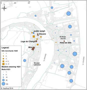
In the sixteenth century, the silk weaving process in Lyons was dominated by the silk merchants and brokers who controlled the distribution of work among the workshops until a new by-law was passed by the Consulate (the city government) in 1619.Footnote 17 This forbade merchants from owning looms, weaving and employing weavers if they were not themselves registered as masters.Footnote 18 Thereafter, trade was socially clearly delimited, integrating weavers and merchant-manufacturers. This change of statute resulted explicitly from the demands of weavers who sought to retain a greater share of the profits and who were deprived of work by the merchants who increasingly controlled workshops in Italy. As a result of this critical change and in response to a severe unemployment crisis, the Consulate commissioned a survey of the silk weaving industry in 1621 which revealed that 1,187 workshops were active, which included substantial enterprises such as those of the merchant Jean Jacques Manis who controlled 81 workshops with 201 looms, Neyret (38 workshops; 87 looms) and Ballet (34 workshops; 59 looms). Just three merchants controlled 347 looms, almost one third of the total number (Figure 1).Footnote 19
Silk weavers and the major locations of the silk trade, 1621. The geography of the silk industry in the context of the 1619 crisis. Major locations of the silk trade, weavers from the 1621 survey (count per quartier) and silk merchants in c. 1640, whose location had remained stable after the crisis. (B. Gauthiez)

Silk merchants at that time were located in the area around the Rue Juiverie and the Loge des Marchands/du Change, close to the Pont de Pierre on the west bank of the River Saône.Footnote 20 Between October 1637 and December 1639, 20 years after the 1619 by-law, 133 merchants were involved in the silk trade.Footnote 21 The majority were very small traders, as 53 (40 per cent) of them each dealt with no more than five bales of silk (0.8 per cent of total). The largest, Boulouzon, with 1,019 bales, accounted for 15 per cent of the total number of 6,814 bales and, with nine other Italian merchants, accounted for about one third of the trade. The location of the silk merchants was also given in a tax list of wealthy residents dating from 1640 which corroborates the information contained in the 1637–39 document.Footnote 22
The locations of merchants in 1637–39 can be compared with those of workshops as given by the survey in 1621. The new by-law, introduced in 1619, obliged merchants to become members of the corporation if they wanted to continue to weave, though some continued to flout this by-law.Footnote 23 However, many merchants complied and some others decided to focus exclusively on commerce, abandoning manufacture altogether. Family members also specialized functionally, as with the Manis family where one member continued to control many workshops and became a merchant-manufacturer in 1621. Another Manis family member focused exclusively on mercantile activities to a significant extent amounting to 80 bales between 1637 and 1639, and may have supplied other family members.
The Royal Mint, from which gold and silver were supplied for the most luxurious silk fabrics, was located nearby the Change area in what is now the Rue du Boeuf. Other important buildings directly associated with the silk trade were the Douane (customs house), where the raw or reeled silk had to be stored in a warehouse on arrival in the city and, prior to taxation, in the public weigh house established nearby in the Rue Juiverie with its new premises in 1626.Footnote 24 Significantly, what emerges from the spatial relations of the Lyons silk trade in the first half of the seventeenth century is that in the period prior to 1640 nearly all the silk merchants decided neither to move to be nearer to the workshops nor to follow the development of weaving production that took place in other areas. Actually, during this period, particularly between 1575 and 1621, the increase in the number of looms occurred mainly on the eastern side of the River Saône, in rather peripheral areas.Footnote 25 Therefore, spaces of wealth and prosperity associated with the silk weaving industry were neatly split in the mid-seventeenth century between, on the one hand, an area occupied by the richest and most important merchants and bankers, often of Italian origin, mainly around the Rue Juiverie and the Change, and, on the other hand, the more widely dispersed and peripheral location of the weavers, some of which were recent developments, like those near the Place des Terreaux to the north-east of the city.Footnote 26
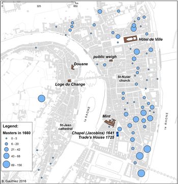
The new by-law of 1619 led to the relocation of the silk industry headquarters from the Change area to the eastern bank of the River Saône where the number of looms continued to increase from 1621 (Figure 2).Footnote 27 This displacement was confirmed in 1641 with the founding of the chapel of the brotherhood to which all weavers had to be attached.Footnote 28 Its location (inside the Jacobins church, Place des Jacobins)Footnote 29 was significant partly for its proximity to the workshops and also because it was politically rather neutral given its relative distance from the power nexus of the city centre (the Consulate was at the Hôtel-de-Ville; the seat of government, the royal administration and the Change were on the west bank of the River Saône). The Royal Mint had recently been relocated from the Change area to a street renamed Rue de la Monnoye close to the Jacobins convent, not far from the argue, a machine used to make gold and silver threads, at the nearby Célestins convent. Similarly, the place where silk had to be weighed before being sold to the merchant-manufacturers was transferred from Rue Juiverie to Place St-Pierre in 1697, where an old public weigh house was reinstated on the ground floor of a new building.Footnote 30 Dangon, an Italian merchant and inventor, was approved as a master and followed the general shift from the Change area to the Jacobins convent area. His workshop was initially located at the Douane, near the Change, then later near the Jacobins convent, Rue Confort.Footnote 31
Silk weavers and major sites of the silk trade in 1660, number per street. In 1641, the seat of the silk trade was located in the Jacobins chapel, leading to the creation of many workshops in the surrounding area. (B. Gauthiez)

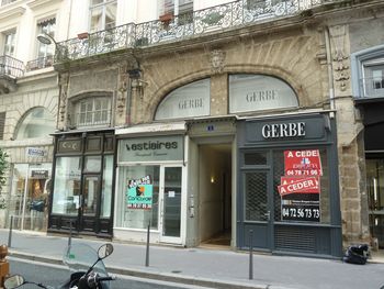
The Jacobins chapel functioned as a communal assembly room for weavers, but the office of the silk trade (communauté) was located within the masters’ premises.Footnote 32 It was an arrangement that generated friction. With silk weaving expanding appreciably in the late 1710s and 1720s, the master-guards decided to invest in a new building for the offices of the trade.Footnote 33 A piece of land was acquired by the communauté, adjoining the brotherhood's chapelFootnote 34 and a building designed by a notable architect (Roche) announced the Corporation's importance in the public space of the city (Figure 3).Footnote 35 Its frontage, Rue St-Dominique (now Rue Emile-Zola) still bears the name of the trade.Footnote 36 The concentration of the institutional buildings around the Jacobins and infrastructural capital associated with the silk trade clearly encouraged the multiplication of workshops in the neighbouring districts, particularly in the proximity of the Hôtel-Dieu hospital, as is evident from shifting locations of masters between 1621 and 1660.Footnote 37 So, the Jacobins area developed in the early seventeenth century as an alternative centre for the Lyons economy. The development of the west side of Rue St-Dominique in 1658 for very high-status flats was no doubt also associated with this changing centre of gravity, and by 1677 had attracted several prominent bankers.Footnote 38
The office building of the silk trade, built in 1725–26, Rue St-Dominique (nowadays Rue Emile-Zola), Roche architect. (B. Gauthiez)

The change that occurred in 1619 was the crystallization of a major shift in capitalist organization. Along the lines proposed by Max Weber,Footnote 39 it conforms neatly to the passage from mercantilism, an organization dominated by the merchants detached from production, to an organization centred on the trade and controlled partly from the inside by the merchant-manufacturers. Increasingly, it was they who directed local production and, by insisting on a maximum number of looms, redistributed production to achieve greater efficiency. This phenomenon is well known in the seventeenth century, but its spatial consequences were significant. The new centre of control for the trade was located independently in a neutral place in the city, and at a distance from the merchants’ quarter. This conforms to the notion of the ‘spirit of capitalism’ in the period, but the capitalists in Lyons were mainly Catholics, not Protestants, as suggested more generally by Weber.
Second spatial logic: the polarization around the Hôtel-de-Ville from 1777
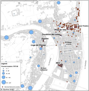
Nonetheless, the development of the silk organization centred on the Place des Jacobins became unsatisfactory to the city government. In the decades following the 1720s, the location of the merchant-manufacturers slowly shifted towards the area around the new Hôtel-de-Ville completed in 1656, and which constituted a new focus for political power. The adjudication of trades disputes had accordingly passed from the sénéchaussée, a royal administration located on the west side of the River Saône, to the Consulate in 1666–67.Footnote 40 The process of spatial change accelerated significantly from the 1730s, as is clearly visible in a survey of 1744.Footnote 41 When in 1776 the minister Anne Robert Jacques Turgot convinced King Louis XVI to suppress all corporations,Footnote 42 the head offices of the silk weaving trade were abandoned and the building sold.Footnote 43 Shortly after, when the trade institutions were reinstated with minor modifications to their previous statute, it was decided to locate them inside the Hôtel-de-Ville (Figure 4).Footnote 44 The new location permitted the city government to exert a greater degree of control over an industry which provided approximately half of its tax revenues. From the late seventeenth century, the silk industry had also become a source of deep political concern. The relocation of its administration ensured a firmer political response to problems such as the insurrections of 1744–45 in which the silk weavers, protesting against a new regulation of the trade favouring the merchant-manufacturers, had played a major part.Footnote 45 More generally, it made it easier for merchant-manufacturers closely aligned with the city government to counter the demands of a numerous group of the poorest weavers. The new administrative location of the silk trade was also driven, however, by a greater degree of gentrification in the area around the Hôtel-de-Ville where many old structures were rebuilt in the course of the eighteenth century by people such as Blaise Denis in Rue Neuve, whose wealth was derived from the silk industry.Footnote 46
The geography of wealth in the silk industry in 1788: poor weavers relieved during the crisis in 1787–88 (per quartier) and associate merchant-fabricants, more or less the biggest merchant-fabricants, from the 1788 Indicateur. After the relocation of the silk trade seat to the Hôtel-de-Ville, the merchant-fabricants regrouped around it. At the same time, the poorest weavers had never dwelled further from this economic centre. (B. Gauthiez)

The area around the Hôtel-de-Ville also became a central place for high-class social activities. Following a fire which destroyed the Grand Theâtre (previously Rue du Plat, near Place Bellecour), a new theatre was rebuilt during 1753–56 by the architect Jacques-Germain Soufflot in the garden of the Hôtel-de-Ville. A square was established between the two buildings (Place de la Comédie) which became the main focus of high-class luxury entertainment and shops in Lyons. At the same time, a new development was undertaken in 1750 to the north-east of the Hôtel-de-Ville,Footnote 47 the Quartier St-Clair along the Rhône riverbank, following the construction of a sizeable building in 1746 by Antoine Tolozan de Montfort, a merchant-manufacturer, silk broker and banker, on Port St-Clair.Footnote 48 A new quay was built connecting the Port St-Clair to the north with the road to Geneva. This area immediately became a major centre for real estate investment by brokers of silk-ware and silk merchants. The Indicateur almanac illustrates in 1788 how the area had become a major housing and trade area for the highest social classes involved in trade and banking.
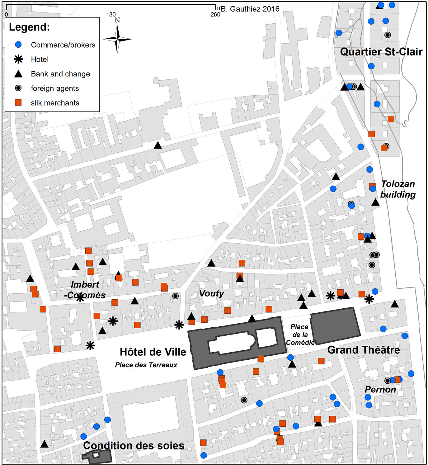
Nearly all the foreign consuls in late eighteenth-century Lyons were located in this Hotel-de-Ville/Grand Theâtre sector of the city (Figure 5). Several major merchant-manufacturers and brokers, like Jacques Imbert-Colomès, a key figure during the Revolution,Footnote 49 or like Camille Pernon, who dealt with foreign royal courts and represented the Russian tsar in the city, had established their premises nearby, in the latter's case at the centre of a block to the south of the Grand Theâtre accessible through a private passageway affording privacy to distinguished clients and visitors. A. Vouty (first name unknown), another powerful merchant-manufacturer linked to the Consulate, had his premises inside a block near the intersection of the Rue Romarin and Rue du Puits-Gaillot, also accessible by means of a private passageway.Footnote 50 High commerce could thus be transacted discreetly, sheltered from the attention and interests of poor weavers. Several hotels that provided accommodation to foreigners were also located nearby, notably the Hôtel du Parc on the west side of the Place des Terreaux.Footnote 51
The centre of the silk trade in 1788 from the Indicateur, around the Hôtel-de-Ville and Place des Terreaux to the west (location at building scale). (B. Gauthiez)

The office of the organization responsible for the city weights and measures was located at the Place St-Pierre. There, the silk was weighed, but its humidity, often a matter of dispute since silk weighed much more when humid and could thus be sold at a higher price, was poorly controlled until a new office, the Condition des soies created by the agronomist Jean-Louis Rast de Maupas, was located in 1779 in the same place to improve and standardize quality. These functions were retained when in 1808 the offices were relocated from the Place St-Pierre to a building financed by the Chamber of Commerce in the Rue St-Polycarpe, to the north of the Hôtel-de-Ville. With its responsibilities for the meticulous control of all silk fabrics, the relocation of the Condition des soies further reinforced the concentration of the silk trading activities in the area around the Hôtel-de-Ville.
The displacement of the silk industry organization from the Jacobins area had political significance in that it implied a closer association with the municipal government, and thus also arguably heightened regulatory control. It corresponded with the spatial reorganization of the commercial elites of the city, and implied a reduced role for the suppliers of gold and silver to the silk industry, as the main bulk of the production was not using gold and silver threads. Another factor was undoubtedly the disappearance of religious control. But, if the central activities of the silk trade moved, the location of the weavers’ workshops did not. The merchant-manufacturers, especially the richer ones and their associates, led the move, but the weavers did not follow. On the contrary, thousands of the poorest colonized the old quarters of the west Saône riverbank, now abandoned by the merchants and bankers. That meant that the greater the social distance, the greater the spatial distance was too.
The new organization introduced in 1619 was very successful, as it allowed for an extraordinary development of the trade.Footnote 52 But the merchant-manufacturers tended to consolidate their power over the weavers, by devoting an increasing proportion of their profits in order to ascend the social hierarchy. Their wealth was a major asset to enter the Consulate and, for some of them, the nobility itself. Their relocation, predominantly around the Hôtel-de-Ville, fully expresses this trend.
The effects of the 1793 bombings
The French Revolution led to a sharp decline in the production of silk-ware, but it was not until 1793 that its impact on the Lyons population became unbearable.Footnote 53 The economic difficulties produced impoverishment for many of the city inhabitants, and were a strong motivating factor behind the rebellion of Lyons against the Jacobin government in Paris in 1793.Footnote 54 The very nature of the Lyons economy explains why some of its workers joined the rebellion since a luxury industry could only prosper with peace between France and its neighbours.
The reaction to the rebellion was immediate and without pity. The siege of Lyons lasted three months, during which the city central area was heavily bombed. As the Hôtel-de-Ville was the seat of rebel command, the area around it was heavily damaged from a battery situated on the east bank of the River Rhône. The result was the total destruction of tens of buildings, and heavy damage to hundreds of others throughout the city. The silk industry was moribund thereafter.Footnote 55
Third spatial logic: the apogee of the 1820s
The building permits approved after the siege show a striking pattern.Footnote 56 The first ones were given to repair damaged buildings and to render them habitable and usable again. Hundreds of repaired buildings thus had new and plain façades in place of decorated ones, largely because of the shortages of building materials and skilled workers. The reconstruction of buildings beyond repair occurred in two phases. Some were rebuilt almost immediately, even by the end of 1794. They included structures in Rue du Garet and Petite Rue Pizay, near the Hôtel-de-Ville, still visible today. Others were reconstructed only when the silk trade resumed a degree of prosperity during the Napoleonic era around c. 1810, but the main bulk of rebuilding took place in the 1820s, a period of extraordinary prosperity for the city associated with an era in which Jacquard looms were widely adopted in the most modern workshops.Footnote 57
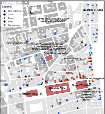
Not only were some poorly repaired buildings razed and replaced by new structures, but entirely new developments took place in the pre-revolutionary religious precincts to the north of the Hôtel-de-Ville and to the west of Quartier St-Clair. These new developments housed different types of economic activities and social groups. Generally, the logic of the late eighteenth-century centralization of the silk industry around the Hôtel-de-Ville was reinforced, so workshop production units were largely unaffected, unlike the economic and financial superstructure. Immediately to the north, the Capucins and Feuillants precincts were developed in the 1800s mainly for merchant-manufacturers and brokers specializing in the Parisian market. In les Pentes de la Croix-Rousse, as this area is now called, new buildings developed along the Rue de la Vieille-Monnaie, formerly occupied mainly by weavers’ workshops. The Cercle des Fabricants (club of merchant-manufacturers) was established there in a new building in the early 1820s (now Passage Thiaffait).Footnote 58 Further uphill, the development of Rue Burdeau and Rue des Tables-Claudiennes from 1821 was geared towards activities associated with weaving and trading.Footnote 59 Higher still, streets developed (Rue Imbert-Colomès, Rue Diderot, Rue Lemot and others) from the late 1820s and were occupied mainly by weavers. The social status of the activities decreased the further uphill they took place. The area to the west of the Jardin des Plantes (outside Figure 6 to the west) was developed in much the same time-frame, with Rue Pierre-Blanc created in 1820, fully built-up and, only a few years later, occupied by hundreds of silk weavers using mainly Jacquard looms and by which point it was the greatest concentration of workshops in the city.
The centre of the silk trade in 1830 from the annual census (location at building scale). The buildings shaded in grey had been rebuilt between 1800 and 1830. (B. Gauthiez)

In parallel, the bombed area around the Grand Théâtre and the Hôtel-de-Ville was largely rebuilt. An entire block of 12 buildings badly damaged in 1793 between Rue St-Claude, Rue Terraille and Rue du Griffon was demolished and replaced by a single magnificent construction in 1830.Footnote 60 Here, substantial sums from the silk-ware commerce, mainly from America, were reinvested by Lenoir and Miège, silk brokers in the 1820s in New York.Footnote 61 Immediately to the south of the Hôtel-de-Ville and the Grand Theâtre, the damaged buildings of the Rue Lafond were rapidly and fully reconstructed in 1824–26 and indeed occupied from 1824 by the Hôtel du Nord.Footnote 62 This high-quality hotel with 85 rooms rapidly established itself as the place where the American merchants and brokers resided when on business in Lyons. The extension of the same building in the Rue du Garet in 1827 housed the American Consulate in 1836.Footnote 63
Both restorations were indicative of the growing importance of Lyons silk Fabrique for the American market, which accounted for 25 per cent of the silk-ware exports from the city in 1825, rising to 50 per cent in 1835. Only the kingdom of Piedmont-Sardinia, Switzerland and Brazil had a consular presence in Lyons at that time and all were located close to the business vortex of the Cercle des Négociants (the Brokers Club) and the Hotel du Nord.Footnote 64 The fact that Georges Capler, the owner of the Hôtel du Nord from 1830, and Louis Cornnaud, tenant of the café located on its ground floor (the most prestigious café in Lyons in 1835) were Swiss points to the internationalization of the social activities surrounding the silk trade in Lyons, and also to the arrival of foreign money.Footnote 65 Many grand cafés and restaurants were located in the area, as the concentration of leisure facilities was considered to assist the conduct of business, as did the presence of a brothel featuring femmes publiques (‘public women’) in a nearby backstreet, Rue de l'Arbre-Sec.Footnote 66
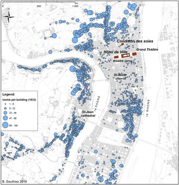
A fully renewed and revived business and high-class centre of consumption eventually developed around the Place de la Comédie in the 1820s, bringing together on the one hand prominent merchant-fabricants, brokers, bankers and silk merchants, and on the other hand the temporary residences of the silk industry major clients.Footnote 67 This trade centre was also associated with the civic authorities in the Hôtel-de-Ville on the west side of Place de la Comédie, and with the hub of the social activities at Lyons, the Grand Theâtre, and its neighbouring cafés and restaurants. The weavers were of course spatially excluded from this privileged area (Figure 7).
Location of the silk looms in 1833, number per building, from the annual census. (B. Gauthiez)

No great change occurred in the spatial structure of the silk trade in the second quarter of the nineteenth century compared to the years before the Revolution. A major consequence of the liberalization of industry and commerce was the reappearance of the great merchants as key players, especially when dealing with markets in the United States. But the merchant-manufacturers also remained powerful because of their indispensable role as intermediaries between the demands of the markets and producers, and due to their management and technical skills when dealing with many workshops scattered throughout the city.
Fourth spatial logic: moving production away from the city
From the late 1840s, the city council began to transform the old centre of Lyons with two main objectives in mind. The first was modernization in the context of a booming economy; the second was social cleansing. The area south of Place des Cordeliers was one of the poorest, occupied by populations that had been very active in the insurrections of 1831 and 1834, when the workers of Lyons, led by the silk weavers, became for a few days masters of the entire city centre between the Hôtel-de-Ville and the Préfecture.Footnote 68 Some 350 buildings were pulled down in 1855–56; this entailed the relocation of 15,000 inhabitants. The new street, Rue Impériale (now Rue de la République) was an immense success, politically, economically and also for the role it played in the concerted attempt to develop a new financial and commercial ‘City’ in a similar vein, and with explicit reference, to the City of London. The northern part of Rue Impériale became the place where several banks located, including in 1857 the local branch of the Banque de France, and in 1863 the Crédit Lyonnais, the first major French bank created outside Paris. The Organization of Silk Brokers and merchant-manufacturers moved to the new Palais du Commerce, despite a first relocation in 1857 to a new building at the corner of Rue Impériale and Place de la Comédie. Not surprisingly, the American Consulate also moved to a building neighbouring the Banque de France. But this immense change in the city space of the centre of the city did not in the event induce a significant change in the location of the administrative structure of the silk industry. A map published in 1944 of the principal ‘maisons de commerce’ (commercial firms) involved in the silk industry shows a striking stability compared to the 1820s.Footnote 69 This means that the weakening of the social incentive to be located in the Hôtel-de-Ville area was counterbalanced by the conservatism of the area functions and inter-relationship of business systems.
This remarkable stability of the main administrative structure contrasts with the move of the production units. In 1833, 90 per cent of the workshops were located within the limits of the walls. About 40 per cent of them were located on the slopes of the Fourvière hill on the west bank of the River Saône; a further 40 per cent were on the slopes of the Croix-Rousse district to the north of the city centre; and around 20 per cent were located in the area around what is nowadays the Place de la République, which was cleared of its workers in 1855.Footnote 70 There was a degree of continuity, therefore, with that of the late eighteenth century. But in 1914, only a very small number of workshops remained in the city centre, occupied by skilled workers and niche producers. In the meantime, significantly, silk entrepreneurs had transferred production from traditional familial workshops to manufactories far from Lyons in the surrounding départements (Isère, Loire, Rhône) employing local manpower – and often womanpower. This made progressively mechanized production possible, accompanied both by lower wages and by employing workers from the countryside which diminished the risks of social unrest with its strong associations in the Lyonnais memory.Footnote 71
Discussion
Mapping the evolution of silk weavers and merchants through the city of Lyons reveals important changes during the three centuries covering the heyday of the industry. In ways unimaginable to the historians Garden and Godart, mapping the dynamics of change of the principal industry and trade of a major city over the long term fundamentally alters an understanding of urban development based on spatial relations. Spaces of power, spaces of influence, contested spaces, spaces of sociability and conviviality and their inter-relationships with other spaces – of production, belief, belonging – have been identified closely, if not exclusively, with structural changes in the silk industry in Lyons.
There is, of course, a degree of interdependence, too, in the direction of such social and cultural changes with wide-ranging connections often associated with the evolution of capitalism generally. By-laws and regulatory frameworks obliged merchants to respond, and the mid-eighteenth-century upturn in merchants’ profits was concentrated in conspicuous consumption at the expense of their workforce. Workers’ responses, mostly unrest and insurrection, reflected this sectional – or class – divergence. This in turn incited employers to detach the residential and occupational parts of their lives, by dwelling in Lyons, but also progressively moving the production out of the city.
The system or sub-system of production in the silk trade of Lyons made up of weavers, merchant-manufacturers, brokers and institutional and financial structures is now more clearly understood in relation to spatial relationships in the city.Footnote 72 There is some endorsement, therefore, of a trade sub-system as described in the modern period by Goody.Footnote 73 Indeed, the silk trade sub-system cannot be separated from the system of poverty relief. Other urban sub-systems were also involved – for example, the control of order during moments of upheaval like in 1619 and 1744–45. Some of them are less directly associated with the silk trade, like housing and the construction of new buildings.
In this research, textual information from archival sources has been incorporated systematically using GIS to develop a clear view of the overall spatial logic in the social patterns of the silk trade. Other sources provide spatial connections to the logic of social and political relations through time. GIS facilitates an analysis of change in these variables which otherwise would be much more difficult to reveal. The parallel made between social data and the changing materiality of the city can be greatly enriched using the locations of building permits. Doing so informs the material space of the city, its transformation and characteristics, reveals socio-political and other organizational features so as to widen the scope of urban history and to understand historical urban space and materiality more fully and convincingly.
Supplementary material
The supplementary material for this article can be found at https://doi.org/10.1017/S0963926820000176.