

Introduction
Accessing nutrients is critical if agriculture is to succeed so that people can feed themselves. Two major and opposing interpretations address historical population–soil relations: Malthusian or Boserupian (McNeill and Winiwarter Reference McNeill and Winiwarter2006). The Malthusian argument relates erosion with population pressure and its growing food demand, expressed as deforestation and cultivation of marginal erodible lands. The Boserupian argument relates highly populated landscapes with active and labor-intensive efforts to conserve and enhance soil stability. Because society is dynamic, farm systems can move from a Boserupian situation to a Malthusian one over time (Cunfer and Krausmann Reference Cunfer and Krausmann2009). Besides, population is not the only factor; livestock densities, nitrogen returned to lands, labor and land productivity, marketable food production, average farm size or land availability, and farm management systems all define these relationships. Climate also limited yields and thus fertility in arid regions where there was competition between land used for human food and that used for livestock feed (González de Molina Reference González de Molina2002). In dry regions, farm communities adjusted livestock numbers to meet draft power needs, while in wetter areas manure availability was more important, as was the case in Austria (Krausmann Reference Krausmann2004). As a result, hot, summer dry Mediterranean regions of southern Europe, including most of Spain, typically suffered from a scarcity of manure in the nineteenth century (González de Molina Reference González de Molina2002). This scarcity of manure in past organic farm systems increased the relative importance of naturally occurring fertilization, such as deposition in rainfall or human-managed (and labor-intensive) techniques such as burial of fresh or burnt biomass. The combination of all these inputs could sometimes make the balance of soil nutrients positive, with more nutrients contributed than extracted during a crop year (Tello et al. Reference Tello, Garrabou, Cussó, Olarieta and Galán2012). By the mid-twentieth century in the developed world, high energy inputs like synthetic fertilizers (temporarily) broke through both of these Malthusian and Boserupian ceilings, as farmers substituted fossil fuels for new land or for intensive labor to restore soil fertility.
The idea within the Spanish history scholars that one of the main challenges for the Spanish society was the backwardness of the agricultural sector from the end of nineteenth century until the Spanish Civil War (1936–39) has instigated a prolific debate (Gallego Reference Gallego2019). “Backwardness” arises when comparing the agrarian productivity of labor with other European countries such as France or Germany. Some blamed the Spanish trade protectionist policies of maintaining artificially the viability of the agrarian sector, thus avoiding the push effects of external labor demand. Others advocate that the explanation should include the social relations of the rural societies and natural factors.
Thus, the social factors that explain the low Spanish agrarian productivity of labor were not only the consequence of punctual policies but also the combination of the complex and decentralized processes generated by the societies that developed them. These so-called rural traditional societies were developed since the beginning of the nineteenth century and experienced their definitive crisis after World War II. They generated self-reproductive systems that consolidated the continuity of farms and social relations, whose main characteristic was a great capacity of retaining agrarian labor (Gallego Reference Gallego, Pujol-Andreu, Gonzalez de Molina, Fernandez-Prieto, Gallego and Garrabou2001).
The natural factors are those aimed to describe the lack of natural endowments of Spanish agriculture, that is insufficient rain to adopt the Norfolk system of rotations, where fallow was eliminated in a four-year rotation system of wheat, turnips, barley, and clover (Garrabou et al. Reference Garrabou, Pascual, Pujol and Saguer1995). Consequently, these conditions, related to the yields pressure of the nineteenth-century fin-de-siècle crisis constrained the capacity to restore soil nutrients as explained in the preceding text.
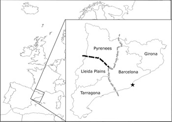
Whereas this was the general context for the entirety of Spain it is also true that the social and natural contexts differed strongly between regions (Gallego Reference Gallego1993). Focusing on the cultural factors, in the region of Catalonia there is a quantification of the nutrient balance for the municipality of Sentmenat circa 1860 (Tello et al. Reference Tello, Garrabou, Cussó, Olarieta and Galán2012). For the beginning of the twentieth century, when some synthetic fertilizers were available but still very rare, there is a qualitative study (Garrabou et al. Reference Garrabou, Pascual, Pujol and Saguer1995). But there are not quantifications that allow for regional comparisons. Accordingly, this article compares the fertilization potential of five Catalan regions (figure 1).
The four provinces of Catalonia (solid lines).
Note: The gray dashed line indicates the aridity frontier. The black dashed line divides Lleida province into Pyrenees and Plains. The star indicates the location of the city of Barcelona.
Source: Author.

Catalan Regions
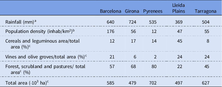
Catalonia, in the northeastern corner of Spain, is divided into two climatic zones (figure 1): the western climate region with low average precipitation (<500 mm annual average) with the administrative units Lleida and Tarragona, and Barcelona and Girona in the east, with higher precipitation levels (Garrabou et al. Reference Garrabou, Planas and Saguer2001a). This climate marker matches with the historical settlement pattern of scattered rural settlements of isolated farmhouses (masies) surrounded by compact units of polyculture farmland of some 5 to 20 or more hectares (10–50 acres) of Girona and Barcelona provinces (Esteve-Palós and Valls-Fígols Reference Esteve-Palós and Valls-Fígols2010: 109). West from the aridity frontier, the landscape is composed by villages surrounded by cropland. We have split Lleida province into two (see appendix), as the northern part, which adjoins the Pyrenees Mountains, had a completely different landscape and settlement history, common to those of mountain areas, isolated and where the development of agriculture was difficult.
From 1870 to 1930, in a trend that was general for Europe, small family farms (either under ownership of tenancy contracts) were increasingly the dominant managers the agrarian landscape. Modest productivity increases did not compensate the high agrarian salaries of the period, causing a decrease of agrarian rents, which weakened the big capitalistic farm property and strengthened the small family farms (Colomé et al. Reference Colomé, Garrabou, Pujol and Saguer1992). In addition, the small family farms were able to articulate with the developing international agrifood system.
Nevertheless, a big share of them left agriculture, unable to self-reproduce. Expulsions from the agrarian sector were constant since the end of the nineteenth century and intensified after the second half of the twentieth century (Garrabou et al. Reference Garrabou, Planas and Saguer2001b). This phenomena was exacerbated in the Spanish regions specialized in cereal crops with low yields, such as Lleida province, reaching high emigration rates (Gallego Reference Gallego1993). From 1950 onward, the tenant-sharecropper system ended and the system of a farm operator who owned its own land was consolidated (Colomé et al. Reference Colomé, Garrabou, Pujol and Saguer1992).
Agroecological Sources
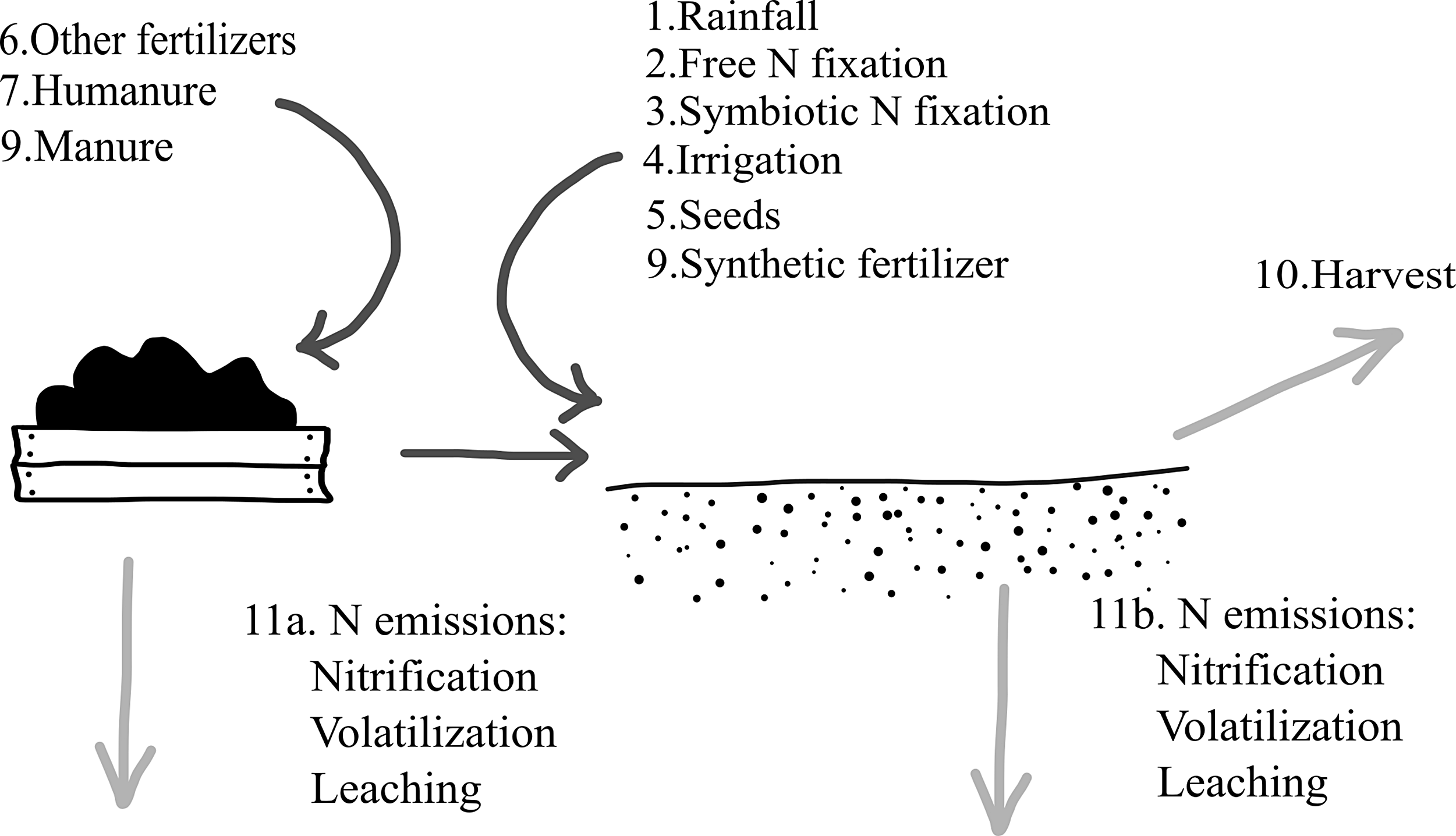
Soil nutrient balances evaluate the three main nutrients that are today applied as synthetic fertilizers: nitrogen (N), phosphorous (P), and potassium (K). The technique for estimating nutrient flows in Catalonia follows the “Guidelines for Constructing Nitrogen, Phosphorus, and Potassium Balances in Historical Agricultural Systems” (Garcia-Ruiz et al. Reference Garcia-Ruiz, González de Molina, Guzmán, Soto and Infante-Amate2012; González de Molina Reference González de Molina2010), adjusted to fit local circumstances (Oenema et al. Reference Oenema, Kros and de Vries2003). Figure 2 presents the basic concept behind soil nutrient balances.
Scheme of the nutrient flows considered in this study.
Note: Dark arrows represent an addition of nutrients, while light gray arrows are nutrient extractions or losses.
Source: Author.

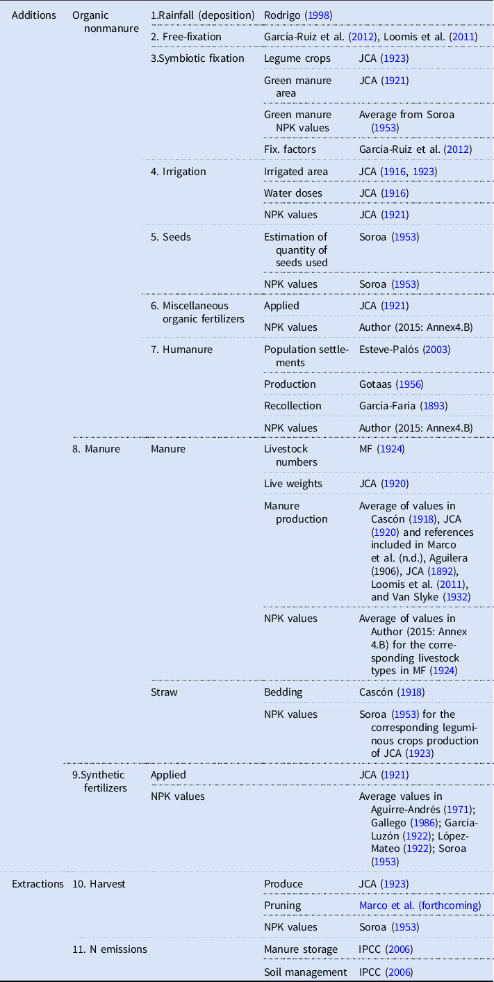
The methodology to calculate the nutrient values lies in two steps: to quantify the volume of each nutrient from primary sources and then to apply nutrient coefficients (table 1). Historical statistical information about agricultural practices in each of Catalonia’s regions is available in the Junta Consultiva Agronómica (JCA), created first in 1879 by the Spanish Ministry of Development to centralize surveys of the agricultural sector. The chief agronomists in each province and their superiors in the capital composed and published agricultural annuals until the reform of 1927, when a new series of agricultural yearbooks began (GEHR 1991). This uses two reports from JCA entitled “Materias Fertilizantes Empleadas en la Agricultura” (JCA 1921) to quantify the use of fertilizers of any kind, plus the yearbook “Avance Estadístico de la Producción Agrícola en España: Resumen Hecho por la Junta Consultiva Agronómica de las Memorias de 1922 Remitidas por los Ingenieros del Servicio Agronómico Provincial” (JCA 1923), which presents the most complete information about Spanish agricultural produce at the provincial scale in the early twentieth century (Soto, D. pers. comm.).
Summary of sources used to construct soil nutrient balances for nitrogen, phosphorus, and potassium (NPK values) in Catalonia, Spain, c. 1920

Previous studies dealing with nutrient balances in historical agroecosystems in the Iberian Peninsula (González de Molina and Guzmán Reference González de Molina and Guzmán2006; Lana-Berasain Reference Lana-Berasain, Garrabou and González de Molina2010; Tello et al. Reference Tello, Garrabou, Cussó, Olarieta and Galán2012) used nutrient coefficients from historical sources, especially Soroa (Reference Soroa1953). That source has limitations because it does not address water content or explain the origins of information presented, including what sorts of instruments and techniques were employed. However, the nitrogen content in plants is highly sensitive to fertilizer applications (Gauer et al. Reference Gauer, Grant, Bailey and Gehl1992). Because synthetic fertilizer applications were low in Catalonia in the 1920s, this study also depends on Soroa (Reference Soroa1953), rather than looking to newer crop nutrient contents derived from modern, high-input agriculture. The analysis complements those data with quantitative and qualitative information from “Catecismos del Agricultor y del Ganadero,” a series of agricultural monographs published in Spain in the twenties and the thirties and authored by some of the most well-known agronomists of the time. They reviewed the common field routines and recommended best practices based on then-available knowledge. The appendix provides detailed explanations of the methods employed to calculate and estimate the key soil nutrient flows captured in the nutrient balances presented in table 5.
Land Use in Catalonia
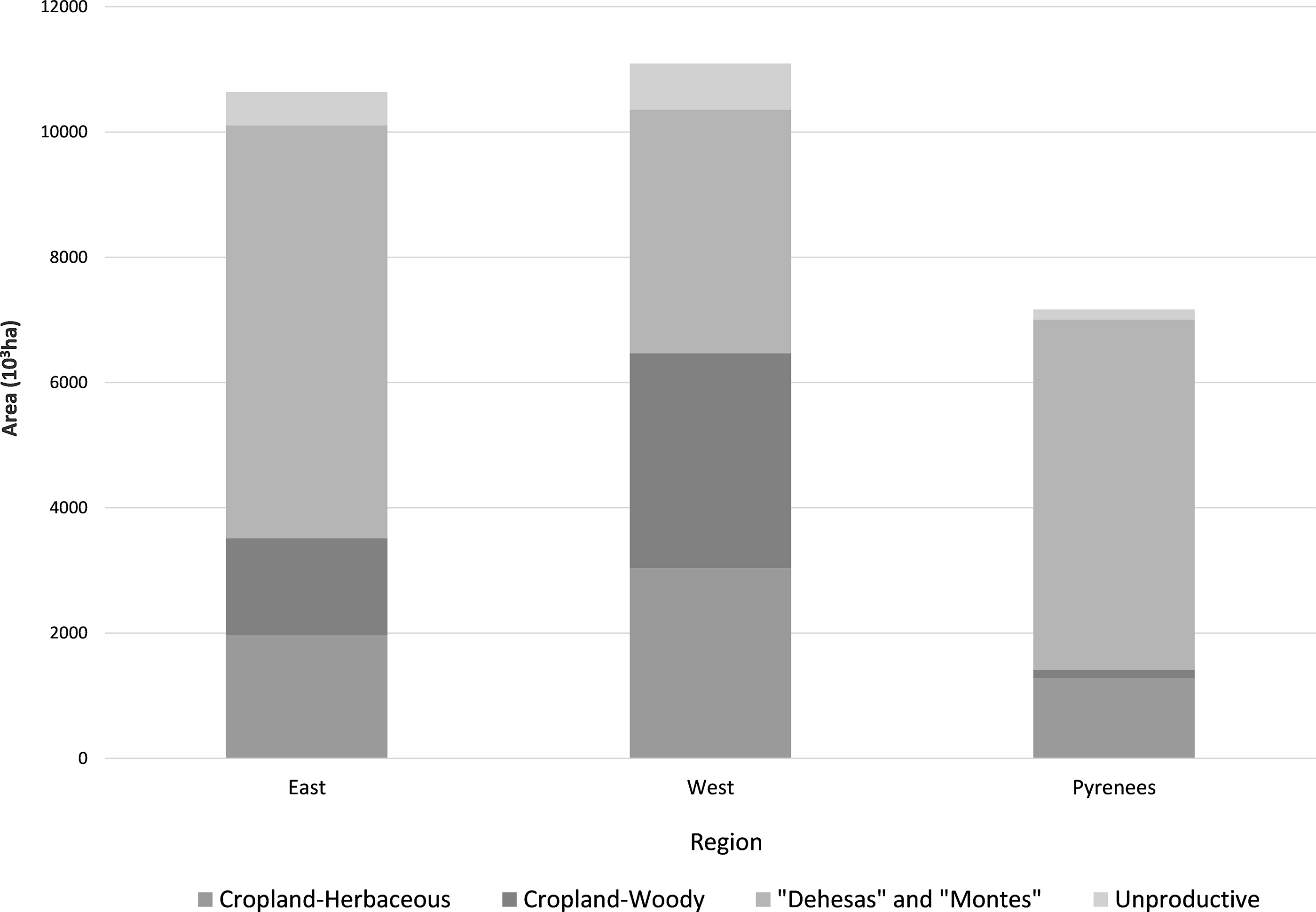
The main two Spanish agricultural specialization patterns between 1860 to 1930 were Mediterranean wooden crops (olive groves, vineyards) and wheat expansion. The latter was made at the expense of pasture and forestland, and was characterized by low yields. Such was the case of Lleida Plains (table 2), where the low and unstable yields, long fallow periods, and low livestock densities made it similar to interior Spain (Garrabou et al. Reference Garrabou, Pascual, Pujol and Saguer1995; Simpson Reference Simpson2003).

Conversely, the larger share of land occupied by permanent covers in Barcelona and Tarragona provinces was due to vineyards. Besides of the Mediterranean specialization, in those areas where enough rainfall allowed it, like in the province of Girona and certain areas of Barcelona, farmers substituted rotations that integrated legume forage, mainly sainfoin, on fallow land (Saguer and Garrabou Reference Saguer, Garrabou, Naredo and Garrabou1995). The cereal yields of these areas were between two and three times higher than those of the plains of Lleida, and thus comparable to the other advanced organic agricultures of northern Europe (Garrabou et al. Reference Garrabou, Pascual, Pujol and Saguer1995).
Finally, a very distinctive feature of Girona was the high livestock densities per cropland area. At higher rainfall, the settlement pattern in masies and the Eastern Pyrenees—the mountain chain that runs through northern Girona, descending in altitude until it drops into the Mediterranean Sea—allowed the coincidence of a relatively small area of summer and winter pastures (Vilà-Valentí Reference Vilà-Valentí1973) within the province. Unlike the other regions, the Pyrenees had large areas of pastures. Those areas, where other agricultural uses were not possible, were connected to the other regions through the seasonal migration of livestock in a declining transhumance system.
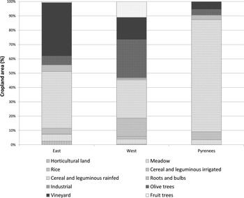
Figure 3 identifies 10 important crop types, each distinguished between “irrigated” and “rainfed.” The latter term includes all nonirrigated crops, for instance cereal under dry-farming conditions, most vineyards, carob and olive trees, or maize in the most humid areas. Although the largest amount of irrigated land was in Lleida Plains, it was only “support irrigation,” that is a minimum amount of water to prevent losing the crop during mild droughts. Hence, the highest soil nutrient inputs from irrigation were in Barcelona and Girona, which had a large area of heavily irrigated horticultural land.
Cropland distribution by land use crop type.
Note: Fallow rotation is considered as Cropland-Herbaceous or “irrigated/rainfed grain” depending on the source.
Source: JCA (1923), plus those sources specified in the text to distinguish land uses in the province of Lleida.

“Grain” captures all cereals and leguminous peas and beans. “Forage” refers to “praderas artificiales,” a common term in Spanish statistics for both leguminous and nonleguminous livestock feed crops such as clover, alfalfa, rye, oats, and sorghum. Farmers usually irrigated forage crops. They cut aerial parts one or more times when they bloomed and used them as fodder in their fresh form or as hay in their dried form. Local industries had strong links with a third category of crops. “Industrial” crops included hemp for fibers and sugar beets for sugar refineries. “Rice,” in the delta of the Ebro River, and some of the “Fruit Trees,” such as oranges or hazel nuts, were already known but farmers started to cultivate them in a new, intensive way at the beginning of the twentieth century in some specific areas of Tarragona, whereas other types of fruit as fruit orchards that were important in the irrigated areas of Lleida Plains (Calatayud Reference Calatayud and Garrabou2006). “Horticultural land” growing fresh vegetables were concentrated around the cities of Barcelona and Girona. The rest of the categories, including “vineyard,” “meadow,” “roots and bulbs,” and “olive trees” coincide directly with those reported in the yearbook of JCA (1923).
Fallow land was not included as a single category, as the primary source considered it part of the rotation with rainfed grain. JCA (1923) registered edible parts of plants grown in horticultural land; legumes and cereal grains; straw; the aerial parts of forage plants; roots and tubers; and fruit from trees, together with wine and oil production.Footnote 1
Although data on interprovincial trade is not available, it is known that Lleida Plains exported mainly wheat but also feed to cover the demands of the city of Barcelona and nearby areas (Pujol et al. Reference Pujol, Nicolau and Hernáncez-Adell2007). The increasing share of land devoted to feed cereals at the expense of wheat, indicates the emerging importance of a still modest livestock sector. This involved a new relationship with cropland in Spain, whose traditional cereal sector was focused on wheat production. Thus, in the first third of the twentieth century, only Barcelona and Lleida provinces had a feed-wheat area ratio (figure 4) similar to the average Spanish levels for the period, by 40 percent (Clar Reference Clar2005). However, in Tarragona and Girona this relation was much higher, due to barley and to maize cropland area respectively.

Although cereal area in Tarragona was small, the low livestock numbers indicate that barley was exported to feed the Barcelona’s increasing pig population. Conversely, maize in Girona, which did not need irrigation as in the other regions due to its higher rainfall levels, probably was devoted to the region’s livestock. All these feed cereal produce was articulated with the increasing urban meat and milk demand from Barcelona.
This trend was broken in the Civil War, and only was overcome in 1965. Since then, and together with the imports of soy and maize for feed, the dramatic increase of the feed/wheat area was one of the most salient changes of the Spanish agriculture in the twentieth century (Clar Reference Clar2005).
Fertilization Materials and Techniques
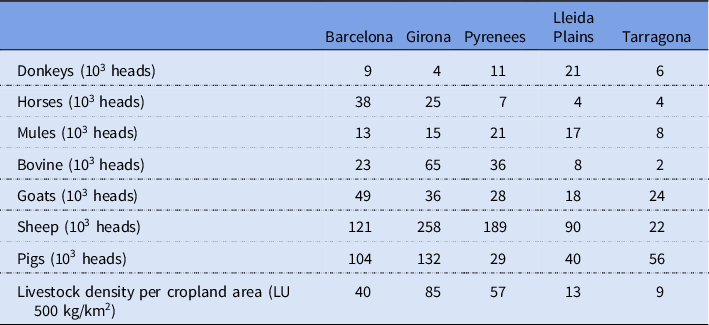
Manure made up the largest volume of organic fertilizer applied, and it is possible to estimate manure availability based on the number of domesticated animals on farms. Table 3 shows the livestock densities in each region.

The allocation of livestock in table 3 gives an idea of the regional articulation of the livestock sector in Catalonia at the beginning of the twentieth century. The livestock sector was immersed in an expansion trend, driven, on one hand, by the increasing urban consumption of meat and milk in Barcelona city and, on the other hand, by the needs of draft power for transportation and industry.
Therefore, the high pig numbers of Barcelona province is linked to the development of the industry of cold meats, former distributors that step by step centralized the transformation process and left farm operators specialize in breeding for export (mainly in Girona province) or breeding and fattening (mainly in Barcelona province) (Pujol Reference Pujol2002).
The composition of bovine livestock category was changing by the increasing numbers of dairy cows, which were imported from other European countries. This was related to the centralization of milk production and treatment next to Barcelona city. First, with cattle milking and sellers called “vaquerías” allocated within the city, whose number peaked in 1920. Since then, the production of milk was established in dairies in the city’s surrounding area. Only at the end of the first third of the twentieth century, the city of Girona reached the milk consumption levels of Barcelona city (>70 L/cap). This was not the case for any urban nucleus either in Lleida (24 L/cap) or Tarragona (34 L/cap) provinces. As a proof of the regional specialization pattern of this proto-industrial system, almost all the milk consumed in Barcelona and Girona was from dairy cows, whereas in Tarragona was only 24 percent (Pujol et al. Reference Pujol, Nicolau and Hernáncez-Adell2007).
The rest of the bovine numbers was mainly in Girona province and some parts of Pyrenees, which were specializing in breeding for exporting to other provinces, either for milk or draft purposes. Nevertheless, draft-purpose bovine breeds started to decay in favor of mix draft/meat breeds. Stud jackasses and mares, whose number of heads peaked around 1920 and then went down (Collantes Reference Collantes2003), concentrated in the Pyrenees. They were specialized in breeding for mules that were exported to southern areas (Pujol Reference Pujol2002). Horse breeding was concentrated in Girona and some parts of Barcelona province (Pujol Reference Pujol2002).
Besides, sheep numbers were following the decreasing trends that started with the crisis on the Spanish wool sector in the nineteenth century and the increasing costs of winter pastures, as the expansion of cereal encroached pastures and intensification (either by rotations or irrigation) decreased fallow lands. Also, the emerging meat and milk sectors required fully housed livestock, thus increasing the competence on lower lands not without conflict (Vilà-Valentí Reference Vilà-Valentí1991). The Catalan mountainous areas were not fully integrated in the cross-country transhumant routes that characterized the Spanish ovine sector, and were mostly local, from Pyrenees to Lleida plains or to coastal areas (Vilà-Valentí Reference Vilà-Valentí1973). Indeed, the Catalan Pyrenees had the lowest livestock density of the Spanish northern mountainous areas at the beginning of the twentieth century, but followed the same decreasing trend (Collantes Reference Collantes2003). Thus, along the twentieth century the Catalan transhumance routes entered in decadence. Became more local, from latitudinal movements toward altitudinal movements, mainly concentrated in those places where agriculture was not profitable (Roigé et al. Reference Roigé, Contreras, Cots, Font, Gómez, Parès, Peret, Ros and Such1995).
Since 1960, the livestock sector together with the urban Spanish diets changed dramatically. Bread consumption dropped as raised meat consumption, with broiler as the most consumed meat type (Clar Reference Clar2005), and the importance of pigs increased even in the Pyrenees. Therefore, after 1960 both chicken and pigs changed their self-consumption vocation and were articulated with the global agrifood system (Collantes Reference Collantes2003).
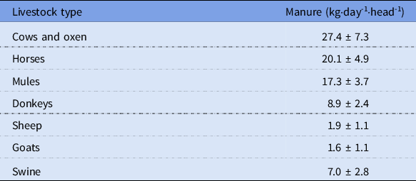
Table 4 presents average manure production per animal. From all the potential manure produced by the livestock reported in census accounts, it is necessary to exclude the manure that could not be collected due to extensive grazing. Only livestock housed or stabled near farmyards could practically be collected and applied to cropland. The soil nutrient balances assume all that manure, and the rich nutrients it contained, was hauled onto crop fields, at a considerable labor cost.
Average manure production for each type of livestock in kilograms per animal per day

Source: See table 1.
A large proportion of the garbage from towns and villages, “barreduras,” ended up directly in fields, as a component of manure heaps, or abandoned in piles on the outskirts and eventually hauled away for fertilizer. Additionally, at the beginning of the twentieth century in Barcelona, there were both legitimate and illegal—“canbuscaires”—collectors of garbage. They competed for organic garbage to feed swine and some poultry that were bred in the city for self-consumption or for small-scale meat and manure markets. A great deal of organic garbage thus remained within the city. Barcelona banned this practice in 1960 to prevent swine fever (CLD 2014).
A distinctive form of cropland fertilization in Catalonia was the “hormiquero.” These “anthills” entailed piling pruning from vines or other woody crops in holes dug into the ground, covering it with soil, and then burning it in the low-oxygen environment. Extremely labor intensive, farmers traditionally used this technique in clearances for shifting agriculture, but also for permanent crops (Miret Reference Miret2004). Sources document this practice in some parts of Catalonia until at least 1960, and it may have been widespread in the arid areas of Catalonia at the end of the nineteenth century (Saguer and Garrabou Reference Saguer, Garrabou, Naredo and Garrabou1995). Unfortunately, we do not have quantitative information about the areas of application. Our main reference for fertilizing methods, JCA (1921), merely documented the destiny of maize straw in Lleida through the spread of ashes from gorse bushes (Ulex parviflorus) and mastic (Pistacia lentiscus), in the coastal areas of Tarragona.
In the opinion of mid-twentieth-century agronomists, farmers abandoned hormigueros quickly once they could substitute synthetic fertilizers for the large quantities of fuel (bushes, vine shoots, etc.) and human labor (Mestre and Mestres Reference Mestre and Mestres1949) previously necessary. However, farmers may have abandoned the practice earlier. Modern studies of the fertilizing properties of hormigueros show that all the nitrogen in the plant matter was lost by combustion, but the remaining ashes increased phosphorous and potassium in soils after the fire (Olarieta et al. Reference Olarieta, Padrò, Masip, Rodríguez-Ochoa and Tello2011). Hence, hormigueros contribute to the nutrient balances for phosphorus and potassium, but not for nitrogen.
Among the possible by-products, only winery and oil pomaces were fully registered. Pruning from vines and olive trees was included as well, either in monetary or weight units, but the amounts were clearly underestimated. This undercounting was due to the large area devoted to vines, which represented half the total cropland in the province of Barcelona (figure 3). Branches could represent a salient export of nutrients from cropland. However, the well-documented uses of vine by-products (Daneo Reference Daneo1921; Mestre and Mestres Reference Mestre and Mestres1949; Soroa Reference Soroa1929) is proof of their importance as feed for livestock or for fertilizer (burned or buried fresh) in the same way as in olive plantations (Infante-Amate Reference Infante-Amate, González de Molina, Vanwalleghem, Soto and Gomez2013). Annual pruning estimations come from Marco et al. (Reference Marco, Padró, Galán, Tello, Olarieta and Garrabouforthcoming).
Other important sources of nutrients in past organic agricultures were those parts of crop plants that remained in the fields after harvest, such as underground roots, stubble, and weeds, particularly if they belonged to the legume family (Garcia-Ruiz et al. Reference Garcia-Ruiz, González de Molina, Guzmán, Soto and Infante-Amate2012). Some of the nitrogen in those materials would have been lost to the atmosphere through decomposition in the ground.
Human waste, here called “humanure,” was another important fertilizer in Catalan agriculture. Dispersed rural settlements applied humanure heaps to fields. Concentrated rural villagers used cesspits, which were sealed or emptied from time to time by farmers. Urban populations had a mixture of cesspits and insufficient sewage systems that released human waste directly into water bodies. A recurrent problem when trying to collect statistical information about the application of human feces is the ambiguity in naming it. The agronomists in charge of the statistics referred to it interchangeably as “abonos flamencos,” “letrinas,” or “fenta,” thus omitting the specific forms of preparation of (usually commercially sold) human feces. For instance, the abonos flamencos were a liquid fertilizer resulting from the fermentation of liquid and solid human feces, whereas fenta or poudrette was the result of drying only the solid part (Llorente and Galán Reference Llorente and Galán1910), each with different nutrient characteristics.
Finally, there were a few nonorganic synthetic fertilizers already available to farmers around 1920. Regular statistics for synthetic and mineral fertilizers did not start until 1928 (Gallego Reference Gallego, Garrabou, Fernández, López and Blanco1986), but an exceptional report of JCA (1921) provides useful information. Gallego (Reference Gallego, Garrabou, Fernández, López and Blanco1986) distinguished five different dynamics of the Spanish consumption of synthetic fertilizers prior to the Spanish Civil War. In his scheme, there was an end of scarcity following World War I, and the beginning of a consumption trend that recovered and surpassed prewar levels. Superphosphates were the main kind of synthetic fertilizer consumed in Spain. Spanish potash (potassium) production did not begin until 1925, and even then it was almost all exported. In Catalonia phosphorous was the dominant synthetic fertilizer during the 1920s (Saguer and Garrabou Reference Saguer, Garrabou, Naredo and Garrabou1995). Pujol (Reference Pujol1998) explains how the low use of synthetic fertilizers in Girona compared to the rest of Catalonia’s provinces resulted from a greater availability of organic fertilizers there. The areas of highest consumption were near industrial centers or places provided with irrigation facilities. Both factors explain why Barcelona led superphosphate consumption in Catalonia.Footnote 2
Soil Nutrient Balances
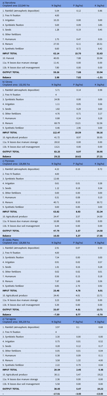
Soil nutrient balances compare the amount of nitrogen, phosphorus, and potassium extracted or lost from the soil with the amounts added, either through natural or through human-managed processes. When balances are near zero or positive, then nutrients might accumulate, or at least not diminish, and the farm system is sustainable, at least from the point of view of soil fertility. When balances are negative, then farming extracts more soil nutrients annually than return, and the farm system may be in a “soil mining,” unsustainable situation. Estimates for each of the several incoming and outgoing nutrient fluxes, and their overall balance, appear in table 5.
Soil nutrient balances for nitrogen, phosphorus, and potassium (kilograms per hectare of cropland) in Catalonia’s regions, c. 1920

Source: Author.
The nutrient balances were positive for the regions with highest livestock densities. In those cases, the more limiting nutrient was phosphorous. The balances show a negative trend in Tarragona and Plains, where nitrogen was in especially short supply. Manure was the most important source of nutrients in nearly all instances, and the Tarragona and Plains had the lowest amount of available manure. Second most important was the nitrogen fixed by leguminous crops. Synthetic fertilizers were more important for phosphorous, and Barcelona used them more than either elsewhere.
The relative importance of each type of fertilizer for the replenishment of nutrients harvested depended on the nutrient examined. Manure was the main source to restock the potassium extracted in all regions. The organic nonmanure sources were more important for nitrogen than for the other nutrients due to rainfall deposition and leguminous crops. They were even more important than manure in Tarragona and Llerida Plains. Synthetic nitrogen (mainly imported Chilean nitrates) was also required to close the balance in Barcelona province, while the role of synthetic fertilizers in Girona was almost null. Chilean nitrates were important for Tarragona’s rice and orange fields. The application of synthetic fertilizers was the most important source of phosphorous in Lleida Plains and Barcelona.
The nutrient balances per area of cropland in the three regions shows that Girona, Pyrenees, and Barcelona compensated for their harvest extractions, unlike Lleida Plains and Tarragona, where a shortage of manure increased the relative importance of other sources of fertility, such as nitrogen deposition through rainfall and free bacterial fixation. Although it is uncertain whether maintaining fallow land was effective for this purpose, its continued existence may be due to the logic of soil fertility pressures.Footnote 3 This effect was most evident in Lleida province, where fallow land made up approximately 30 percent of all cropland, and less so in eastern provinces, where fallow was almost nonexistent (JCA 1923).
During the nineteenth and the beginning of the twentieth centuries in Spain, it was commonplace to say that, despite regional variations, there was not enough livestock density to produce the manure needed for cropland (Simpson Reference Simpson2003). A number of Spanish agronomists at the beginning of the twentieth century advocated for a complementarity between organic and synthetic fertilizers. They recommended reinforce the recycling of biomass by applying waste products from industry, including sugar refineries, fisheries, canneries, wineries, oil presses, and leather and wool manufacturers. Another recommendation was to employ green manures, redileo (livestock confined overnight), or the spreading of processed human excrements, garbage, or ashes (Cascón Reference Cascón1918; García-Luzón Reference García-Luzón1922; Llorente and Galán Reference Llorente and Galán1910; Rueda-y-Marín Reference Rueda-y-Marín1934). More imaginative proposals included the use of algae and a detailed process to dig ditches to capture locusts when they swarmed, toasting the dead insects with fat and benzene before compacting them into fertilizer (Soroa Reference Soroa1929). Virtually all agronomists recommended farmers calculate the flows of the main nutrients—nitrogen, phosphorus, potassium, and sometimes calcium and iron—or analyze soil composition and purchase synthetic fertilizers as supplements. According to agronomists of the time, soils required 5–6 tons per hectare of semidecomposed manure or 6–7 tons of fresh manure (Llorente and Galán Reference Llorente and Galán1910). The present analysis shows that this perceived scarcity of manure in Spain was not true for Girona (see appendix), where was possible to apply the recommended amount of manure, thus agreeing with Pujol (Reference Pujol1998) who said that its natural endowments allowed sufficient livestock numbers to maintain soil fertility.
While in the region of the Pyrenees there was an excess availability of nutrients from manure compared to what was extracted, most of it would have dropped on pastures too dispersed for collection, and therefore not available to cropland. However, there is not have enough data to specify whether cropland in the Pyrenees received enough manure. In comparison, Tarragona and Lleida Plains presents a different picture, as the additions of nutrients barely balanced the extractions. This is consistent with González de Molina’s (Reference González de Molina2002) argument that sustaining or increasing soil fertility by organic means was more difficult in arid climates, mainly because of a shortage of grass, hay, and forage for additional livestock.
Also, as a kind of perfect organic loop, the belts of horticultural land surrounding cities and supplying their fresh vegetables and fruits, were also the destination of humanure from those same cities (Billen et al. Reference Billen, Garnier, Némery, Sebilo, Sferratore, Barles, Benoit and Benoît2007). Horticultural land around Barcelona was already important by 1920. All sources confirm that farmers fertilized them with almost everything they could get their hands on. Interestingly, in despite the small percentage of horticultural land, soil nutrient extractions from horticultural land were quite significant due to high yields; two or three harvests could be obtained each year.
The analytical scale of these soil nutrient balances is regional, therefore, a general equilibrium across a region does not necessarily mean that all crop types were balanced. The opposite could be true if farmers specifically directed fertilizers toward cash crops. Such was the case for rice, oranges, and hazelnuts on the richest lands (Calatayud Reference Calatayud and Garrabou2006; Garrabou Reference Garrabou and Garrabou2006), creating a soil mining trap in the rest of the cropland area. The sources employed in this article do now allow disaggregation by individual crop, so it is not possible to evaluate definitively whether a regional equilibrium meant that all cropping subsystems were also balanced, only that the physical means to do so were available.
What were the implications of deficient fertilization? Maintaining an annual deficit over time would have undermined the capacity of soils to sustain the population, or even increase yields should population grow. In other locations, long periods of underfertilization caused yields to decline until they reached a low level and stagnated there. This trend was demonstrated with experiments at the Broadwalk plots in Rothamsted Station, UK, where grain yields finally stabilized at 900 kilograms per hectare after 50 years of unmanured continuous wheat cropping (Shiel Reference Shiel, McNeill and Winiwarter2010). Experiments at Sanborn, Missouri, in the United States found that wheat yields stagnated at 600 kilograms per hectare after 30 years of unmanured cropping (Shiel Reference Shiel, McNeill and Winiwarter2010). Similarly, after 80 years without fertilization, a rye field in Germany reached an equilibrium near 900 kilograms per hectare (Loomis et al. Reference Loomis, Connor and Cassman2011).
And what were the implications of an excess of fertilization? When released from soils into the environment, some chemical forms of nitrogen are greenhouse gases and contributors to acid rain. The leaching of nitrogen and phosphorous from soils into surface water fosters eutrophication (oxygen starvation) that causes animal die-offs and lost biodiversity as well as threats to human health. The release of nitrogen into the environment depends on the amount of fertilizers added, their storage, and the management of soils (IPCC Reference Eggleston, Buendia, Miwa, Ngara and Tanabe2006). But excess fertilizer application was not a serious concern around 1920 because there was an accumulated deficit, at least in some areas, so that an annual positive balance probably did not lead to pollution. Some suggestions by the agronomists of the time (Cascón Reference Cascón1918; de la Cruz-Lazaparán Reference de la Cruz-Lazaparán1924) aimed at diminishing nitrogen deficits followed this same logic. They intended to develop techniques that would minimize nitrogen losses and enlarge the nitrogen content of the fertilizers applied. Ironically, no longer driven by scarcity but now by excess, these same techniques are being implemented in Catalonia today in a top-down strategy to reduce nitrogen emissions to the atmosphere and groundwater pollution (Penuelas et al. Reference Penuelas, Sardans, Alcaniz and Poch2009).
The versatility of the soil nutrient balance methodology complicates comparisons between different places and periods. The results should always be evaluated in context. A surplus or balance of nutrients does not mean environmental damage per se. Depending on its characteristics, a system might be able to store or dissipate excess nutrients. For example, soils with low fertility could increase their storage capacity for nutrients. This premise was the basis of Allen’s model showing an increase in English farm yields due to the long-term assimilation of nitrogen through “convertible farming” and rotations of leguminous crops (Allen Reference Allen2008). Although it is not usually considered in historical soil nutrient balances, the elapsed time can affect the quantities of nutrients (Öborn et al. Reference Öborn, Edwards, Witter, Oenema, Ivarsson, Withers, Nilsson and Richert Stinzing2003). For example, adding a certain amount of synthetic nitrogen fertilizer in a soluble form during the rainy seasons can result in high losses through leaching. The addition of the same amount of nitrogen in manure, which is less soluble, means that some of the nutrients may be released right away while others may only become available for the following harvest year, meaning fewer losses.
Aside from biophysical conditions like climate and geology, the social and economic factors that influenced the availability of fertilizers seem endless. Examples include whether laws or rules imposed by landlords that allowed or limited livestock numbers, forage cultivation or green manure; the organization of farmer cooperatives or unions, which spread knowledge about synthetic fertilizers; and competition with other uses of manures, such as gunpowder (Güldner et al. Reference Güldner, Krausmann and Winiwarter2016), and hence the influence of wars and conflicts.
Beyond a limitation for interpretation is the risk of evaluating a nutrient balance as the only factor in soil fertility. Koning and Smaling (Reference Koning and Smaling2005) reflected on the utility and limitations of regional nutrient budgets applied to policy making and the mistake of neglecting other dimensions, such as the dynamics of world markets or the rehabilitation of local agricultural knowledge in the design of soil policies for Africa. Olarieta et al. (Reference Olarieta, Rodríguez-Ochoa and Ascaso2008) warned about the reductionism involved in the accounting of nutrient flows as if they were the only dynamic of soils affecting agrarian productivity, criticizing monetary valuation methods of soil degradation. This mistake could lead to the fallacy that chemical fertilizers can replace soil fertility without taking into account the role of organic matter. Soil organic matter is a “complex bio-organo-mineral system” (Manlay et al. Reference Manlay, Feller and Swift2007) indispensable for the biological functioning of soils—and therefore of biogeochemical cycles and mineralization—and cation-exchange capacity (Feller et al. Reference Feller, Blanchart, Bernoux, Lal and Manlay2012; Manlay et al. Reference Manlay, Feller and Swift2007). Furthermore, recent studies relate the influence of compost in the prevention and treatment of some plant diseases (Litterick et al. Reference Litterick, Harrier, Wallace, Watson and Wood2004). These issues are far from the scope of this study, but it is worth remembering that a nutrient balance cannot be used to estimate the soil organic matter, soil acidity, or the health of soil microorganisms in 1920, all of which were relevant for overall crop productivity and soil health.
Conclusion
Because versatility is both the advantage and the limitation of building soil nutrient balances, this analysis explicitly follows existing peer-reviewed guidelines presented in García-Ruiz et al. (Reference Garcia-Ruiz, González de Molina, Guzmán, Soto and Infante-Amate2012) to enhance comparability with other published studies. While eastern and Pyrenees regions had sufficient available means to balance their soil nutrient flows, such was not the case in the Tarragona and Lleida Plains. In this situation, these regions maintained low yields and could not enhance them, which made their farm systems more vulnerable to Malthusian population and economic limitations.
In the better-endowed regions there were differences in the strategies that farmers employed to close their cropland balances. The Pyrenees region and Girona province could still rely entirely on organic strategies in 1920. Some of those management techniques did not require human labor, but many demanded large amounts of hard, physical work, such as stabling and feeding livestock, collecting and hauling their manure, gathering and hauling humanure, growing green manure crops, and planting seeds, as well as others that may have been important but did not appear in official statistics. The availability of these organic sources of fertility depended not only biophysical factors such as rain, but upon economic and social factors too. The province of Barcelona was perhaps a paradigmatic example of the coming transition toward another, nonsolar and nonrenewable mode of agriculture (Krausmann et al. Reference Krausmann, Schandl and Sieferle2008) because the province balanced its nutrient flows by combining all these organic strategies with the use of imported synthetic fertilizers.
Unlike studies in other places and periods, nitrogen was not the only limiting nutrient for all types of agriculture at the beginning of the twentieth century (Allen Reference Allen2008). Wherever there was enough organic means to fertilize (or stronger Boserupian forces, i.e. labor supply), phosphorous became the most limiting nutrient. The application of synthetic fertilizers was the threshold at the end of one era of organic-based fertilization strategies and the beginning of a growing separation in the material relationship between urban and rural places (González de Molina Reference González de Molina2010). Only in an earlier era, prior to the use of synthetic fertilizers and when manure sources were limited, such as Tarragona and Lleida in 1920, was nitrogen the main limiting nutrient. This fact has already been reported by Allen (Reference Allen2008), but in a later stage and yet before the widespread distribution of industrially synthesized nitrogen, phosphorous became the most limiting soil nutrient, as was the case in the eastern regions.
Finally, regarding to the historical context, the demand of wheat, vegetables, draft power, milk, and meat of the city of Barcelona played a central role shaping the regional agrifood system of the first decades of the twentieth century. This trend was interrupted by the Spanish Civil War (1936–39), and shifted to another scale when, since the sixties, this regional food system started its integration with the global agrifood system, which involved imports of feeds, the establishment of pig and broiler as main source of proteins, and the end of the traditional rural societies. This new scenario changed the role of the livestock sector from potential fertility carrier to pollution source.
Acknowledgments
I am very grateful to Geoff Cunfer and Laura Larsen for the English language correction and final editing of the text. This research was supported by the Canadian Social Sciences and Humanities Research Council, Partnership Grant 895-2011-1020 and the Spanish MICINN JdCF2016 No. FJCI-2016-30263.
Supplementary material
To view supplementary material for this article, please visit https://doi.org/10.1017/ssh.2021.27