Introduction
Norse immigrants from Europe settled during the Medieval Warm Period in southern Greenland in around AD 985 and farming communities were established close to the coastlines, predominantly in the inner part of deep Greenlandic fjords. Greenland has been inhabited since middle Holocene times, but the settlement history has been characterised by a discontinuous succession of cultures (McGhee Reference McGhee1996; Gulløv Reference Gulløv, Fitzhugh and Ward2000; Appelt and Gulløv Reference Appelt, Gulløv, Appelt and Gulløv1999; Meldgaard Reference Meldgaard2004).
Relative sea level changes associated with glacio-isostatic adjustments during early-middle Holocene are significant in Greenland and are connected with an isostatic response of the Earth's crust to the last deglaciation (for example Weidick Reference Weidick1972; Donner Reference Donner1978; Rasch and Nielsen Reference Rasch and Nielsen1995; Dietrich and others Reference Dietrich, Rülke and Scheinert2005; Wahr and others Reference Wahr, van Dam, Larson and Francis2001). The marine limit varies throughout Greenland and is located around 40–60 m above sea-level in southern Greenland and up to 140 m above sea-level on the west coast of Greenland (Weidick Reference Weidick, Escher and Watt1976; Kelly Reference Kelly and Andrews1985; Rasch and Nielsen Reference Rasch and Nielsen1995; Funder and Hansen Reference Funder and Hansen1996) (Fig. 1). The early Holocene regressive phase reversed during the middle Holocene as a result of a glacio-isostatic response induced by neoglacial readvance of the Greenland inland ice (Kelly Reference Kelly1980). This resulted in a neoglacial submergence that transgressed and drowned early-middle Holocene coastlines (Weidick Reference Weidick, Escher and Watt1976; Long and others Reference Long, Roberts and Wright1999). The major transition from emergence to submergence took place between 8 and 2 ka BP depending upon the location (Weidick Reference Weidick1993). The sea level reached its lowest level around 10 m below highest tide in southern Greenland between 8000 and 6000 cal. yr BP (Sparrenbom and others Reference Sparrenbom, Bennike, Björk and Lambeck2006). The late Holocene readvance of the Greenland inland ice might have caused the subsidence at the outer coasts of Greenland in the order of about 10 m (Kelly Reference Kelly1980). A relative sea level rise in the order of 1 m/1000 yrs since BP 800 has been documented in west Greenland (Rasch and Jensen Reference Rasch and Jensen1997; Long and others Reference Long, Roberts and Wright1999) with a peak rate of sea level transgression at around AD 1400–1500 (Weidick Reference Weidick1993; Rasch and Jensen Reference Rasch and Jensen1997). Even within the time span of one generation relative sea level rise is today evident in the Nuuk area, west Greenland (C. Andreasen, personal communication, 2006).
Relative sea level changes in Greenland modified from Bennike and others (Reference Bennike2002). 1. South Greenland. 2. Disko Bugt, west Greenland. 3. Jørgen Brønlund Fjord, north Greenland. 4 and 5. Nioghalvfjerds Fjord, inner and outer part, northeast Greenland. 6. Washington Land, northwest Greenland. The south Greenland curve extends further back in time compared to the north and central west Greenland curves due to the earlier deglaciation of South Greenland. The south Greenland sea level curve drops below present sea level in the early Holocene. This only occurs during middle or late Holocene times at other localities.

Evidence of pronounced late Holocene sea-level changes in southern Greenland is presented in this paper with special emphasis on the last 1000 years. The possible implications of these sea level changes with progressive loss of fertile coastal land for the Norse society living in Greenland from AD 985 to approximately 1500 are discussed.
Methods
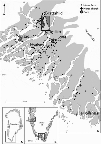
A reconstruction of late Holocene climatic and environmental changes based on terrestrial and marine records has been undertaken in the Igaliku Fjord region of southern Greenland (Fig. 2). The study area covers the central part of the former Norse Eastern Settlement, which was inhabited around AD 985–1500. The work includes results from a marine geological cruise in 1998 (Hoffmann and others Reference Hoffmann, Kuijpers, Thiede and Party1999; Kuijpers and others 1999; Lassen and others Reference Lassen, Kuijpers, Kunzendorf, Hoffmann-Wieck, Mikkelsen and Konradi2004; Jensen and others Reference Jensen, Kuijpers, Koc and Heinemeir2004) and subsequent fieldwork (Mikkelsen and others Reference Moors, Jensen and Kuijpers2001). Investigations of sediment cores from the deeper part of the fjords (>300 m) involved an approach including analyses of geochemical, lithological, micropalaeontological and palaeomagnetic parameters (Kuijpers and others Reference Kuijpers, Abrahamsen, Hoffmann, Hühnerbach, Konradi, Kunzendorf, Mikkelsen, Thiede and Weinrebe1999).
Map of Greenland with a rectangle marking the area of investigation (A). Map of western Greenland with the location of the Western and Eastern Settlements of the Norse (indicated by W and E) (B). Map of the Eastern Settlement showing the location of the Narsaq and SIF4 cores and a rectangle indicating the location of Fig. 5.

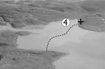
A sediment core (SIF4), 0.80 m long and with a diameter of 10 cm, was retrieved from a sheltered bight of a tidal flat, approximately 5 m from the present coast line off Igaliku Kujalleq (Figs. 2, 3) where once a prosperous Norse farmstead was located. The core consists of 75 cm of homogeneous mud overlying a sand horizon with plant remains at the core bottom. 210Pb and 137Cs measurements (Kunzendorf and others Reference Kunzendorf, Longva and Paetzel1996) of the core revealed no measurable 210Pb activities in the sediments, whereas the 137Cs activities increased from the surface to a depth of 0.1 m suggesting an age close to 1950 for that level, where the peak activity is attributable to nuclear bomb testing in 1963. This gives a recent sedimentation rate for the core in the order of 200 cm/1000 years and corresponds to results from the study of nearby lake sediments, where detectable 137Cs activities were indicative of rapid sediment accumulation during the past approximately 50 years (Sandgren and Fredskild Reference Sandgren and Fredskild1991).
Aerial photograph, looking in an east southeast direction, of the Igaliku Kujaleq area with the tidal flat and the location of core SIF4 (Circle). The church in the former prosperous Norse settlement is marked by a cross and the approximate extent of sea bed exposed at low tide is indicated. This area might have been farmed by the Norse but was gradually drowned by the rising sea level.

Plant remains (grass) from the sandy unit in the lower part of core SIF4 were dated at the Leibniz laboratory of Kiel University (Laboratory Number KIA 16935) yielding a 14C age of 415 ± 20 BP, which corresponds to a calibrated calendar year AD 1451, that is an age of around the time when the Norse disappeared. The sediments of the core and the dated plant remains are similar to the present day beach environment and represent a drowned beach suggesting a sub-recent average subsidence rate of more than 130 cm/1000 yrs, which is in the same range as the figure indicated by the 137Cs data for recent subsidence (approximately 200 cm/1000 yrs).
Rates of submergence
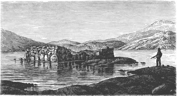
A low sea-level stand of late Holocene age has been documented in the study area near Narsaq (Fig. 2) and is based on a desiccation crust at 9.3–10 m below present sea-level in a marine core (Foged Reference Foged1979). 14C dating of a marine shell above the desiccation horizon at 8.25 m below present sea-level has an age of 2680 ± 110 14C years BP (approximately 2800 calendar years BP) (Weidick Reference Weidick1996; Bennike and others Reference Bennike, Björck and Lambeck2002). This suggests an average late Holocene relative sea-level rise of approximately 300 cm/1000 yrs. A later phase of Holocene relative sea-level rise in southern Greenland is documented by, for example, the Norse ruins in Igaliko which were already more than 125 years ago, close to or below sea-level at high tide (Steenstrup and Kornerup 1881) (Fig. 4). In west Greenland the rate of relative sea-level changes was periodically enhanced during the last millennia. Rasch (Reference Rasch2000) and Rasch and others (Reference Rasch, Jacobsen and Nielsen1997) found evidence of transgressions around AD 1300 and 1600 with transgressions peaking at AD 1400–1500 in the Disko Bugt area of west Greenland (Rasch and Jensen Reference Rasch and Jensen1997). With the subrecent rate of about 200 cm/1000 yrs, found in core SIF4, and the average rate of about 300 cm/1000 yrs over the last 3000 years in the survey area, periodically even higher rates exceeding 300 cm/1000 yrs may have occurred in southern Greenland. Comparable to the transgression peak at around AD 1400–1500 in the Disko Bugt area (Rasch and Jensen Reference Rasch and Jensen1997), the rate of subsidence was probably rapidly increasing simultaneously in southern Greenland, that is during the termination of the Norse era. The rapid increase is illustrated by the present day location of the Norse graveyard at Herjolfsnæs (Ikigaat) in southern Greenland (Fig. 2) (Nørlund Reference Nørlund1924), which was in use until at least AD 1430 (Arneborg Reference Arneborg1996; Arneborg and others Reference Arneborg, Heinemeier, Lynnerup, Nielsen, Rud and Sveinbjørnsdottir2002). Even though a distinction between coastal erosion and subsidence can be difficult in areas with coastlines of un-consolidated sediments, evidence of subsidence is unambiguous in areas where a bedrock coastline is overlain by a thin cover of sediment. The graveyard at Herjolfsnæs is resting on bedrock and is today close to sea-level at high tide and a relative sea-level rise in this area is estimated to exceed one metre during the past 600 years, that is after the Norse ceased to use the graveyard. During the Norse era from AD 985 to approximately 1500, relative sea-level rise has also exceeded one metre, and the possibility of even faster rates particularly during the final stage of this period (AD 1300 to approximately 1500), must be seriously considered.
Sketch drawn in 1876 of a 14th century Norse ruin at Igaliko in the Eastern Settlement, southern Greenland (from Steenstrup and Kornerup Reference Steenstrup and Kornerup1881). See Fig. 2 for location. The base of the ruin was well below sea level in 1876, that is only 400 years after its completion. This points to a substantial relative sea-level rise in the area.

Discussion
During the relatively warm Middle Ages a group of Icelanders, called the Norse, settled in southern Greenland in around AD 985. The Norse were mainly farmers and therefore to a large extent dependent on the productivity of their pastures to provide fodder for their husbandry. However, the importance of farming declined as the food sources became increasingly marine (Arneborg and others Reference Arneborg, Heinemeier, Lynnerup, Nielsen, Rud and Sveinsbjörnsdóttir1999). The settlers populated two areas on the southwest coast of Greenland. The Eastern Settlement was the largest and was located in the southern part Greenland, whereas the Western Settlement was founded 500 kilometres further to the north (Fig. 2).
The Norse settled in Greenland just after the culmination of the Medieval Warm Period. Water temperatures of the fjords may have reached values almost 4°C warmer than during the 20th century (Lamb Reference Lamb1977). Terrestrial soil temperatures were also relatively high, as the Norse could sink their burials deep into the ground, which, after the Norse era, was hardened by permafrost (Nørlund Reference Nørlund1924). Late medieval cooling in Greenland began around AD 1311–1326 and peaked about AD 1350 (Barlow and others Reference Barlow, Rogers, Serreze and Barry1997a). This cooling event was followed by a warmer period that was terminated by the first minima of the Little Ice Age around AD 1550 (Dahl-Jensen and others Reference Dahl-Jensen, Mosegaard, Gundestrup, Clow, Johnsen, Hansen and Balling1998; Lassen and others Reference Lassen, Kuijpers, Kunzendorf, Hoffmann-Wieck, Mikkelsen and Konradi2004). This 14th century cold spell was the period of lowest temperatures recorded in central Greenland for 1000 years (Dahl-Jensen and others Reference Dahl-Jensen, Mosegaard, Gundestrup, Clow, Johnsen, Hansen and Balling1998).
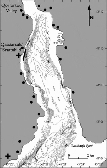
Side scan sonar investigations were performed in 1998 off the present day small community of Qassiarsuk, which has been identified as the Norse settlement Brattahlid and thus is one of the oldest Norse settlements in Greenland (Fig. 5). Side-scan sonar records reveal a drowned beach at a tidal-corrected depth of about 3 m below mean sea-level and at a distance of 110 m from the present coast line (Kuijpers and others 1999). Using the information from the near by 14C dated Narsaq core, this suggests that the fertile lowland available at the time of the initial Norse settlement extended more than 100 m into the fjord relative to the present day coast line at Brattahlid. Rough estimates of land lost by the Brattahlid community due to 500 years of rising sea-level amounts to approximately 50 ha from the initial to the final phase of the Norse colonisation period (W. Weng, personal communication, 2005). In addition, approximately 200 ha slightly further to the north of Brattahlid was lost due to the relative rising sea-level. Other shallow water areas depicted on present day bathymetric maps in the Tunulliarfik Fjord region (Fig. 5) may also represent Norse arable land, which was gradually drowned by the rising sea.
Bathymetry of the inner part of Tunulliarfik Fjord obtained with a multi-beam echo sounder (from Hoffmann and others 1999). Norse farms are indicated by dots, churches by crosses. The thick black line indicates the location of the drowned beach mentioned in the text.

Rising sea-level thus relentlessly reduced the extent of the precious coastal lowlands used for pastures and hay fields. This situation was an impediment to Norse husbandry to which the farmers had to adapt. It has been argued that Norse culture foundered because it clung to a poorly adapted farming economy (Barlow and others Reference Barlow, Sadler, Ogilvie, Buckland, Amorosi, Ingimundarson, Skidmore, Dugmore and McGovern1997b; Pringel Reference Pringel1997) and because social and ideological factors created a vulnerable society (McGovern Reference McGovern1991). Recent 13C analyses of human bones from Norse graveyards have shown, however, that the Norse adapted to the changing environmental conditions by a gradual dietary shift from predominantly terrestrial food and dairy products to mainly marine food (Lynnerup Reference Lynnerup1998; Arneborg and others Reference Arneborg, Heinemeier, Lynnerup, Nielsen, Rud and Sveinsbjörnsdóttir1999). The Eastern Settlement apparently was a viable community in the middle and later part of the 14th century. Icelandic documents describing a wedding in an Eastern Settlement church in AD 1408 is the last written information about the Norse in Greenland, and only 14C dates of clothing from graves provide evidence that the Norse were still in Greenland around AD 1430 (Arneborg and others Reference Arneborg, Heinemeier, Lynnerup, Nielsen, Rud and Sveinbjørnsdottir2002). At this stage the Norse were facing a steadily rising sea-level and a deteriorating climate with increased storminess, falling temperatures and expanding sea ice (Lassen and others Reference Lassen, Kuijpers, Kunzendorf, Hoffmann-Wieck, Mikkelsen and Konradi2004; Jensen and others 2004).
Conclusions
The Norse society in Greenland was undoubtedly facing a number of socio-economic and environmental problems that caused their decline after almost 500 years of existence at the northernmost edge of European civilisation. One of the environmental problems they faced was the steadily rising sea-level. This would have caused the gradual loss, from one generation to the next, of precious land and this negatively affected the farming potential of the community. The general environmental and climatic deterioration at the transition from the Medieval Warm Period to the Little Ice Age probably brought their living conditions to a critical point.
The manner of demise of Norse society during its final phase in Greenland is, however, still an unsolved question. The changing environment undoubtedly threatened their existence. This presumably led to the Norse settlers gradually abandoning their farms and leaving Greenland perhaps for Iceland from where their pioneer ancestors originally set out five centuries earlier.
Acknowledgements
Financial support from the Nordic Arctic Research Programme (NARP), the Science Foundation of the Greenland Home Rule Government and the Danish Natural Science Research Council is greatly acknowledged. Ole Bennike (GEUS) and Svend Funder (University of Copenhagen) kindly commented on the manuscript and provided helpful comments. Thanks are also due to the anonymous referees for their helpful comments on an early draft of this paper.