

Introduction
In this article, I examine land as a topic in social discourses of belonging in a southern Chinese village in the coastal area of Guangdong Province about a hundred years ago.Footnote 1 The study comprises a detailed examination of a cluster of fields that the village residents claim are theirs. The settlement contains an agnatically conceived lineage type of community whose members carry the family name of Wong. The enquiry attempts to contribute to earlier work on lineage building in late imperial southern China.Footnote 2 Above all, the aim of the article is to advance the emerging discussion of the articulation of continuities in Chinese society. It provides a detailed picture of landed property in a poor settlement, which has a documentary value in its own right. The village is situated in a rural area of Lantau Island in the New Territories of Hong Kong. Since the 1980s, it has formed part of an enormous international airport project. What remains of the village today is included in a sprawling suburban development.
When anthropologists and sociologists try to make sense of southern Chinese social organisation and community life in the ‘traditional’ imperial state, they have tended to devote their work primarily to more wealthy areas. Land has been discussed as both an economic asset and a political condition for the distribution of power and influence locally and regionally. A particular interest has been vested in land as a prerequisite for the building of lineage organisations. These endeavours have been informative in many ways, but we should also consider the importance of land in relatively poor communities, where, apart from being one economic asset among others, its distribution among members of the community provided a guide to the structure of local society. Archival data, such as those discussed in what follows, may throw some interesting light on the formation of the social landscape in less well-endowed areas in the south of China.
In southern China, the soil was thus not only a material asset for the production of the main means of livelihood, rice, but also a forceful symbolic idiom carrying latent arguments activated in the social discourse of belonging; ownership to land informed on ties between people. There was also a clear political dimension involved in that the accumulation of landed possessions reflected—indeed, was—wealth, and wealth implied power, which again might generate further wealth. This is clearly reflected in the land records that are analysed in this essay. What is highlighted in this work is that access to land formed a robust symbolic document informing social life. To trace a man's possession of land was to trace his place in a series of increasingly inclusive belongings. In late imperial times, there was no radically new use of agricultural fields that would have promoted change in the tenancy of land. The abandonment of formerly cultivated lots or introduction of new crops may have been distorting factors in the social process, but that kind of influence would have changed conventional notions only very slowly. Whatever legal changes were introduced from the extra-village world, they would also have modified the scene only gradually and by way of some continuous, long-drawn social negotiation, mediated by courts of justice, village leaders, religious functionaries and elders.
In the 1970s, Wong Ka Wai was an independent lineage parish in the Tung Chung Valley of Lantau Island on the eastern side of the New Territories, since 1899 as part of the then British Crown Colony of Hong Kong. The village domain was inhabited exclusively by men carrying the patronymic family name of Wong and their sisters and wives, together forming a recognised group of agnatic descent. These connections between residents were further announced by the village's designation: Wong Family Enclosure. Despite its name, there was actually no surrounding wall or fortification to be found here; architecturally, the village was a modest affair of a few terraces of smallish mud-brick houses. There was a main concentration of narrow buildings and a second similar, but smaller, cluster in the immediate vicinity, a little to the west. The village was situated close to an old Qing dynasty fortress, which, when in operation, would have provided some protection for the nearby settlements. By the middle of the last century, Wong Ka Wai was a Hakka-speaking community of around forty souls.Footnote 3 Seemingly, the Wong people did not always form a recognised official community of their own; in an earlier period, they were regarded as part of the nearby settlement of Lung Tseng Tau, a multi-surname neighbourhood containing the lineages of Chen, Hung, Kiu and Tang. In this wider settlement, the Wongs were the largest group: in the 1911 General Census Report,Footnote 4 Wong Ka Wai is listed as being inhabited by forty-seven persons and ‘Lung Chau T'au’ (sic!) by forty-eight. When the Crown land records were prepared in 1904—five years after the British occupation of the New Territories—the division between the two settlements seems certain. Even so, at that time, some Wongs gave their address as Lung Tseng Tau, but most of them named Wong Ka Wai as their place of residence. Some landowners named different villages for different plots to the 1904 British land surveyors and were accordingly registered under two addresses. In terms of local politics, the two settlements had probably been regarded as quite separate for a long time.
As I saw them in 1974, most houses in the village were quite old, possibly the very same as those that had been seen and recorded in 1904. These mud-brick structures of one floor were covered with white-washed plaster and had tiled roofs supported by wooden beams. The entrance led into a small ‘atrium’, where to the left, as one entered, was the stove. The small cemented courtyard was sunk into the ground as a basin to avoid rainwater penetrating the inner chamber. The main part of the house was divided by a wooden screen, on which, facing the door, was the shelf with the ancestral shrine. Behind this wooden partition, people slept; in front was the ‘drawing room’, where various everyday tasks were performed. The terraces were separated by long narrow lanes.
Situated among steep and wooded mountains, the well-watered Tung Chung Valley was predominantly a rice-producing area. Seen superficially, little could be discerned of outside influences, and there was a conspicuous absence of large-scale market gardening for urban centres, a feature that dominated many other areas of the New Territories at that time.Footnote 5 The area had some reputation for its cultivation of shallots.
It may be noted that in the political idiom of the day, in the early years of the 1970s, the Wong Ka Wai villagers were known to be left-wingers. Living in a marginal area of the New Territories with an old type of agriculture, they seemed to be outside the flow of rapid economic developments that were so characteristic of the colony of those days, and they appeared to resent that fact. My work in the field was brief and primarily intended to supplement my archival research.
Sources Used
The material analysed in the following pages was found in the Schedule of Crown Leases—Lantau Island, signed by the Governor of Hong Kong, Sir Cecil Clementi, in 1904. The files used were marked ‘Tung Chung D.D. 1–3’. The schedule formed part of the ‘Memorials of the Land Office, District Office South/Islands’ files that in 1974 were kept by the District Office Islands. The land register of the schedule is generally regarded as the result of very careful survey work carried out by expertise brought in from India.Footnote 6 It formed the basic source of reference for all matters connected with land in the New Territories. Even so, the files occasionally contain entries that are factually inaccurate. For instance, genealogical notes in connection with issues of inheritance are often simplified and misleading, being the results of enquiries in the field when ownership was negotiated or disputed. Doubt is brought out by comparisons with the actual land records as such, which must be deemed trustworthier than specific entries made by visiting land officers investigating cases of succession. Kinship claims that appear in such notes at times indicate that only those concerned were relatively closely positioned in the Wong genealogy. For instance, ‘uncle/nephew’ should not always be interpreted in the narrow sense: often a closer examination reveals a case of more distant collateral relations. Such statements were no doubt discursively authentic but not true in a factual order of things. Another feature calling for caution is that at times dates of birth were given a considerable time after a person's death, and then perhaps only as rough estimates, despite their appearance of preciseness. For instance, if we were to believe that one of these Wong Ka Wai entries, one man, very unlikely, would have had a son at the age of eleven. Dates of death are probably more accurate.Footnote 7
The Wong Domain in 1904
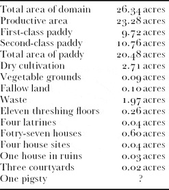
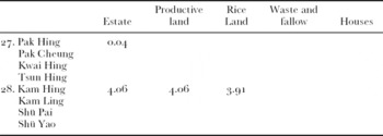
The corpus of land lots registered as owned by members of the Wong lineage is drawn from the survey of 1904, when old imperial deeds and traditional documents were exchanged for Crown land leases. We know that in imperial times the whole area here was claimed by the powerful Li lineage of Nam Tau across the water in Chinese territory. Tung Chung people paid fees to the Li lineage collectors on an annual basis, and the ‘surface rights’ of these tenants were regulated by ‘white’ deeds. The deep-soil ownership—recorded as ‘red’ deeds—that was claimed was not always recognised by the British and need not be explored further here.Footnote 8 The New Territories were annexed to the Crown Colony in 1899 and the survey work started soon after. The body of entries concerning the Wong Ka Wai domainFootnote 9 can be tabulated as follows (
Table 1):

Estates in 1904: Single-Owner Estates
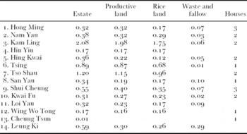
Table 2lists all single-owner estates—the name of the owner, characteristic features and acreage.Footnote 10

Estates in 1904: Double Ownership
Table 3lists all estates on record in 1904 with two joint owners:

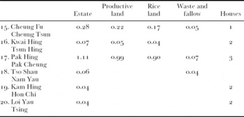
Estates in 1904: Triple Ownership
Table 4lists all estates recorded in 1904 with a joint ownership of three persons:

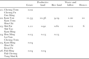
Estates in 1904: Quadruple Ownership
Table 5lists all estates of 1904 with a joint ownership of four persons:

Distribution of Wealth in Terms of Productive Land and Rice Land
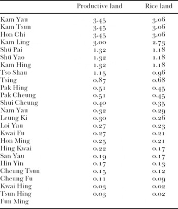
Tables 6 and 7 record relative wealth in Wong Ka Wai in 1904 and are based on ownership in terms of private holdings and shares in corporate property. They list respectively title to productive land—paddy, dry cultivation and vegetable grounds—and rights to the economically more vital wet rice land. There are slight differences between the two tables. We must remember, though, that any wealth that was generated by other activities outside the sphere of agriculture and land does not appear in
Table 6.

The Wong Ancestry as Expressed in Landed Estates in 1904
It is not known whether the Wong lineage community ever kept a genealogical record, but at the time of my fieldwork in Wong Ka Wai no such account seemed to exist. This means that our analysis cannot be buttressed by textual evidence of kinship relations. Nor was there much help to be obtained from their ancestral hall; being Hakka they maintained only one collective memorial tablet for their common ancestors. Land offered them an alternative symbolic idiom to formal language in written records. The account of ownership encapsulated a document of ancestral history and parish development. What follows here, then, is an attempt to understand the emergence and continuity of the local Wong lineage through an exploration of the distribution of land among the membership of the parish. Furthermore, it explains the importance of very small lots and why people seem to have clung to insignificant portions of, for them, useless land. The picture may not be complete, as a number of features might easily have escaped my attention. Some members of the community may not have left traces behind in the records, any property they had having been added by inheritance to the holdings of collaterals in the absence of direct descendants. Others may have sold their property and left. Another feature is that, as mentioned above, there is a certain vagueness regarding relative age among the members of the lineage. Even so, some preliminary help can be found in the District Office files.
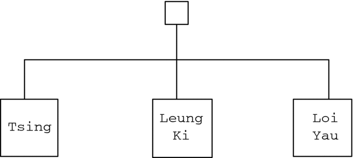
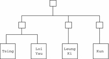
One good starting point in this exercise is Estate 20. It consists of two houses of 0.04 acres together. Thus, the two houses are fairly large. They are said to be owned by Loi Yau and Tsing. The former man is supposed to have lived between 1892 and 1934, while the latter between 1876 and 1930. One diagram shows Tsing and Loi Yau as brothers, the former sixteen years the elder, but it also shows that there was another brother in this set, Leung Ki. This last brother is said to have lived between 1883 and 1935 (Figure 1). But as Leung Ki has no share in Estate 20, it seems very unlikely that this claim to brotherhood was, in fact, accurate. In 1904, the property remained in the hands of two actual brothers, while their presumed brother Leung Ki having at that time neither house nor land of his own in Wong Ka Wai. Rather, it seems as if he were a resident of the township of Nam Tau (Nantou), which is situated across the waters of Deep Bay, in Chinese territory. In all likelihood, Leung Ki was not a brother but a FaBrSo. However, the records also claim that Leung Ki died in Wong Ka Wai on February 4, 1950, at the age of sixty-eight. Now, there is an obvious confusion here; this latter entry is certainly wrong and refers to yet another man, Kun (1882–1950), with no property at all in Wong Ka Wai in 1904. In another file, Kun is said to be a cousin of the three brothers Leung Ki, Loi Yau and Tsing. The most plausible interpretation of the data at hand is that the link between these men was to be found one generation further back in comparison with that indicated by the file. The fathers of these four men were three brothers, who had split between them whatever little property had been left to them by their father (Figure 2).
Fig. 1
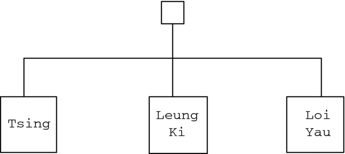
Fig. 2

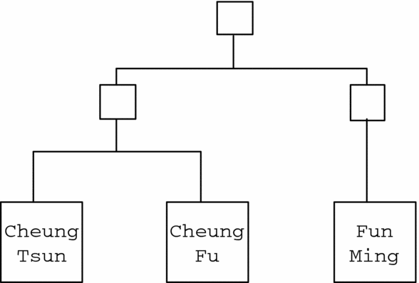
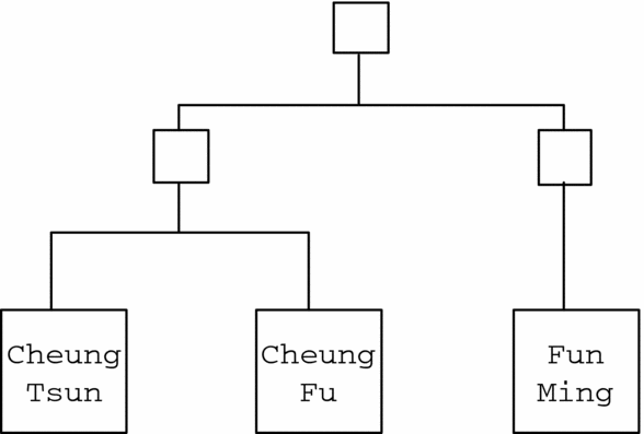
The next phase in our examination brings attention to Estate 15. Cheung Tsun and Cheung Fu are reported to be the owners. We have no dates for these two men. Their names indicate that they were true brothers, an assumption strongly supported by the fact that they were the co-owners of this property. Besides Estate 15, Cheung Tsun and Cheung Fu had shares in Estate 21—a threshing floor. A third owner here was Fun Ming, an otherwise landless person. The joint ownership of this Estate 21 is best explained if we assume that this threshing floor had been inherited from their common grandfather (Figure 3). We have no further information about Fun Ming.
Fig. 3
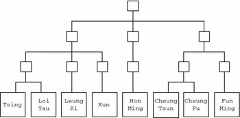
Estate 24 is of interest here as it connects the two earlier mentioned kinship clusters. Two rice fields were owned jointly by Loi Yau, Cheung Tsun and a third man, Hon Ming, who died in 1925. There is no other property to unite these three men. This estate must have been inherited from a common ancestor, minimally three generations above these men. On the other hand, it must be noted that neither Leung Ki, Tsing, Kun, Cheung Fu nor Fun Ming were registered as shareholders in this land. Obviously, Loi Yau, Cheung Fu and Hon Ming were recorded as the owners of these two fields as representatives of three different branches of a segment of the lineage, each being a shareholder in this ancestral estate. Presumably, the three owners mentioned were the oldest representatives of senior branches at the time. If this is true, Loi Yau should be older than Tsing, despite the dates given in the file. But the names listed could also reflect physical availability in 1904 when the register was made. Our reconstruction of this lineage segment would now look approximately like Figure 4.
Fig. 4

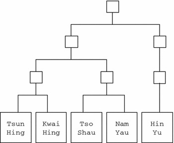
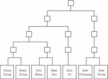
Next, we must examine the property of Hin Yu (already deceased in 1915), Tso Shau (1850–1911), Nam Yau (1865–1926), Kwai Hing (1863–1926), Tsun Hing (1854–1919), Pak Cheung (1866–1924) and Pak Hing (1887–1930). To judge by the distribution of property among these men, we are dealing here with three pairs of brothers: Tso Shau/Nam Yau, Kwai Hing/Tsun Hing and Pak Hing/Pak Cheung. Brotherhood is also indicated by various notes found in the file. The two last-named pairs have typical brother names of metonymic construction. Kwai Hing and Tsun Hing have equal shares in Estate 16. Similarly, Pak Hing and Pak Cheung are co-owners of Estate 17. Both these cases may be best regarded as property inherited from their respective fathers. Moving on, we find that these four last-mentioned persons are all joint shareholders in Estate 27, again a large threshing floor. A simple interpretation would be that this was originally the property of a common grandfather. However, some further evidence, which is discussed below, contradicts this particular explanation.
Tso Shau and Nam Yau jointly owned Estate 18, apparently sharing what was once their father's threshing floor and latrine. What else the father might have left to his progeny had been divided and added to their respective private estates, 7 and 2. Both Kwai Hing and Tsun Hing died without issue, and their respective properties were inherited by a descendant of Tso Shau. This means that these two pairs of brothers were closely related, perhaps as cousins. Although not conclusive, it may still be possible that the nearly equal size of the two inherited estates, 18 and 16, reflects such a relation of cousinhood.
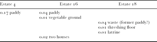
Hin Yu, the owner of Estate 4, was clearly related to these cousins. On Hin Yu's death, his property was inherited by a descendant of Tso Shau. A comparison of Estates 4, 16 and 18 provides a further clue (
Table 7):
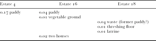
Our reading of these data suggests that the three holdings in Table 8 were once a single unit of property, which on the death of the owner was split in such a way that one son received the agricultural land—one large field—and the other the two houses, the threshing floor and latrine. In addition to this, a very small portion of rice land was transmitted to the son inheriting the houses, perhaps for reasons of local citizenship—defined by access to both land and house.Footnote 11 Furthermore, some paddy land in what was to become Estates 16 and 18 may have drifted out of joint ownership and been turned into private lots—Nam Yau's piece of land registered as D.D.1: 843 is adjacent to D.D.1: 842 belonging to Estate 16. Estates 16 and 18 were established by a further partition of the ‘house’ bundle of the original holding. This exercise in interpretation, when transformed into the graphics of a kinship model, provides us with the set of relationships shown in Figure 5.

*Estate 26 includes the share of Tang Shui Kiu.
Fig. 5

We are now in a better position to understand Estate 27, discussed above. This threshing floor was the corporate property of a major segment, which must find its apical focus at least four generations back from the registered owners of 1904. The two pairs of brothers each represent one of two subsegments. Genealogically speaking, Kwai Hing and Tsun Hing are likely to be senior to Tso Shau and Nam Yau, the father of the former couple being the elder of two brothers in the ascending generation (Figure 6).
Fig. 6

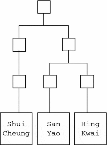
One entry in a file states that Shui Cheung (1864–1914), San Yau (1880–1923) and Hing Kwai (1881–1921) were brothers. They had no property in common, but each of them possessed a private estate: 8, 9 and 5, respectively. Their names do not indicate brotherhood. Shui Cheung and Hing Kwai both died without issue, and their respective holdings were inherited by a descendant of San Yau. I suspect, however, that the three men were not as closely related as stated in the official files. My difficulty in accepting the register's version lies in the fact that the three ‘brothers’ did not share any property at all. We may note that Hing Kwai's and San Yau's holdings were just about the same size, whereas Shui Cheung's was more extensive. If we compare their respective acreage of productive land, we find that this was related in the proportion of roughly 1:1:2. Furthermore, if the dates of birth given for the three men are reasonable estimates, Shui Cheung was about fifteen years older than the other two. These facts are strong pointers indicating that perhaps the two last men were true brothers, or, more probably, cousins, that is, were descendants of a pair of brothers. Shui Cheung was a collateral relative of the first two men, or alternatively a son of a cousin of their fathers. We may speculate that the link between the three men was to be found three generations back in time (Figure 7).
Fig. 7

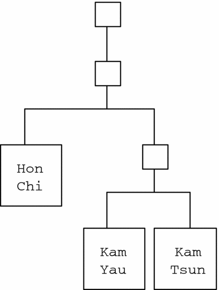
In 1904, the most important property of the Wong domain was Estate 22. Three owners are on record—Kam Yau, Kam Tsuen (both still alive in 1974) and Hon Chi (dead in 1907). The first two were brothers with metonymically linked names. The fact that the three men were of two different generations and the circumstance that they had equal shares in this holding provide evidence that there must have been a set of two men of the older generation—Hon Chi and, I assume, Hon Chi's brother—who were once co-owners; the presumed brother died before 1904 and was succeeded by his sons Kam Tsun and Kam Yau (Figure 8). Hon Chi's grandfather was, presumably, a certain Wai, whose painted portrait was still kept on the shelf of the domestic ancestral shrine by his descendants in 1974. I was told in the village that Wai had been an official in Kowloon City, the sub-magisterial seat of the Chinese Government in the upper part of Kowloon Peninsula. It seems likely that this, by local standards, unusually large holding of land reflected his administrative position.
Fig. 8
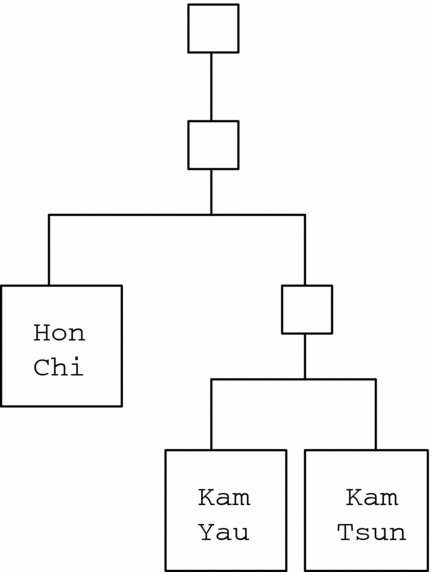
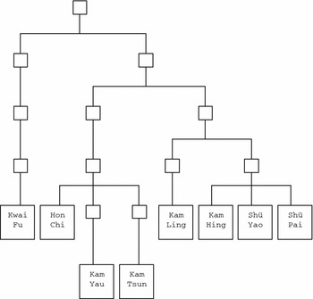
Estate 23 is registered in the name of three men—Kam Hing (1870–1935), Shü Pai (1874–1934) and Shü Yao (1888–1936). These men may have been brothers. Estate 28 includes a fourth owner, Kam Ling (1865–1914). This entry should be read as a joint ownership including a set of three brothers and their cousin. Again, these four men, owners of Estate 28, were in some way linked to Hon Chi, Kam Yau and Kam Tsun. Kam Hing and Hon Chi were co-owners of Estate 19, which consisted of two houses and a threshing floor. This was surely an ancestral property with reference to an apical forefather one generation above the public servant Wai, and it had remained a permanent focus for a segment of two branches. Estate 25 is also of interest in this connection. Being a large threshing floor, it was owned jointly by Kam Hing, Hon Chi and Kwai Fu (1895–1925). In this entry, we find a clue to a major segment of the lineage, united by an apical ancestor four (or five) generations above the landowners of the 1904 register (Figure 9).
Fig. 9

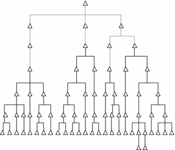
Thus, on the basis of the land grants of 1904, it is possible to reconstruct three major segments of the Wong lineage. My tentative reconstruction suggests six generations, including the apical forefather, before the 1904 men. It is likely that these three segments found their common union in one ancestor in the founding father of Wong Wing Wo (sometimes written Woa), in whose name there was a trust, Estate 12, consisting of one field of paddy and a house, now an ancestral hall. Of course, there could have been one or several one-son generations in between, or a loss of collaterals, but I have ignored these possibilities here. Furthermore, village informants were convinced that the Wongs had been there for five generations before its present inhabitants, but to these must then be added the founding father and his sons according to the reconstruction. On the forum of land distribution, we should expect that the founding of the village took place some time between 1750 and 1775. The overall picture is that given in Figure 10, which (approximately) accounts for the whole agnatic lineage of the name of Wong as it had developed by 1904.
Fig. 10

Before we conclude this discussion, we must pay some attention to Estate 26. The registered owners were Pak Hing, Pak Cheung and, to judge from the name (‘water beauty’), a woman named Tang Shui Kiu. This is the only instance of ownership crossing the boundary of lineage (and gender). Nothing is known about this woman, besides the fact that she owned another field, registered in her name and under the address of Wong Ka Wai. She might have possessed more land in the neighbouring village of Lung Tseng Tau—where there was a lineage by the name of Tang—but I have not explored this possibility. Perhaps, she was a trustee for a son, but as there was no registered succession to this lot by 1973, this would mean that she was a very small girl in 1904. However, Pak Hing died in 1930 and Pak Heung in 1924. Estate 26 clearly poses a problem that cannot be solved here. It is likely that some relevant data have not found their way into the land register.
A final remark is in order here. It was stated above that there were three major segments to the Wong lineage, which all manifested themselves in collective ownership, that is, in the maintenance of joint ancestral properties (Estates 24, 25 and 27). However, this means that Hing Kwai, San Yau and Shui Cheung have been excluded from the analysis. The difficulty with them is that they are registered only as owners of private land. Simply because of this, there is no reason to assume that in some way they formed a fourth major segment, unrepresented in terms of either land or houses. Even so, it was a fact that corporate units could dissolve, as shown by later history, such as the collapse of an entire major segment in 1915 by the sale of its common property (Estate 24). How these three men were linked to the three segments cannot be determined on the basis of our present data. Perhaps, they had shares in corporate Estates 24, 25 or 27, where only one name for each branch is listed. There is an unlikely possibility that they were not related at all, but people from any of the several Wong lineages that occupied small hamlets in the Tung Chung area. But then, a shared surname would hardly have been an entrance ticket to a denizenship of Wong Ka Wai.Footnote 12
The Distribution of Land Within the Village
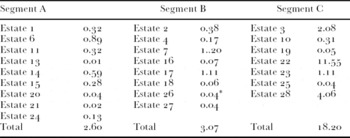
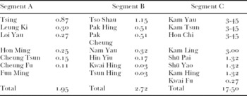
The land records give us an opportunity to depict relative prosperity in terms of the land owned by the three major segments, which are called here A, B and C (Table 8).
The properties of Hing Kwai, San Yau and Shui Cheung amount to 1.25 acres together.
Relative Wealth of Landowners
On the basis of the same material, we could also establish the proportionate wealth of landowners in terms of lineage segment and rice land (
Table 9):

Shui Cheung was in the possession of 0.40 acres, Hing Kwai 0.22 and San Yau 0.19; all together, these men owned 0.81 acres of paddy.
In Segment A, Tsing was the most important landowner. Apart from 0.27 acres (which matches the area of Loi Yau's land), he must have added 0.60 acres to his inheritance by his own endeavours. We may guess that he had access to external income, perhaps from work abroad or employment as a seaman. Who possessed this land before the purchase is not known. In Segment B, Tso Shau stands out as the most prosperous man. Apart from the 0.32 acres, which seems to be inherited (see above), the property registered in his name had been added by his own purchases. He must have bought at least 0.83 acres—from whom is unknown. In Segment C, all land seems to have been inherited. There is a concentration of acreage in one intermediary subsegment and, again, in particular in one minor segment. Wong Wai is the key historical figure here. Probably, his brother profited somehow from this relationship; whatever the case, the latter seems to have grown into some local importance. It is only Kwai Fu who is too distant a collateral relative to have a share in the wealth accumulated in the fourth ascending generation of the lineage segment. Kwai Fu's land is of medium size by the standard set by the two other major segments.
It is quite obvious that most people of Wong Ka Wai could not have relied solely on land for a livelihood. Charles J. Grant states that ‘a rice farmer required at least 1.5 acres in order to make a living for his family’.Footnote 13 Chiu Tze Nang, writing about the ecologically similar Sai Kung Peninsula, says that ‘with an average holding of 1.3 acres per family the farmers can only produce enough food for six months.’Footnote 14 Of the twenty-five recorded landowners of Wong Ka Wai in 1904, only seven had more than 1.3 acres, and—together with Kwai Fu—they formed one major segment of the lineage. In practical terms, one major segment had land, while the two others did not. And within the landed segment, only four owners had an area sufficient to provide staple food for a whole year. According to C. T. Wong, a 1961 survey revealed that the average size of farms in Tung Chung was, surprisingly, as small as about 1 acre, and the average incomes from them therefore very small.Footnote 15 Only eight Wong Ka Wai men had more than 1 acre of land. The remaining seventeen owners’ farms were of the average size of 0.27 acres. We might compare these figures with those for the Cheung lineage of Pui O, who were situated on the other side of the mountains, across Lantau Island. There, in 1904, the largest individual landowners were registered with 5.99, 3.99 and 3.24 acres, respectively. There were in the area few people holding more than 3 acres of land.Footnote 16
There is one final remark on the distribution of land in 1904 in Wong Ka Wai. In computing the relative wealth, I have treated Estates 24, 27 and 25 as co-owned by the registered owners. It may be more correct to regard all segment members as joint holders of these corporate properties. This would only affect Segment A, but even here the difference would be slight: Tsing, 0.89 acres; Leung Ki, 0.32; Loi Yau, 0.25; Hon Ming, 0.23; Cheung Tsun, 0.13; Cheung Fu, 0.13; and Fun Ming, 0.02.
Houses
In an essay on the occupancy level of houses in the New Territories, Howard Nelson points to the difficulties inherent in the data on houses in the land records of the New Territories.Footnote 17 If we divide the number of existing houses in Wong Ka Wai in 1904 (47) by the number of people according to the 1911 census (47), we find that each individual had a house—which for obvious reasons is not a very likely situation. As this cannot reflect normal family life, it indicates that many families had several houses. We must bear in mind that not all ‘houses’ were intended for habitation. According to the 1904 land map, some buildings were pretty small and some very narrow; they may have been sheds for tools or some other use. Why people owned several houses remains uncertain, but this should reflect demographic processes of expansion and atrophy. The records say that Hong Ming had 3 houses, Nam Yau 2, Kam Ling 2, Hing Kwai 2, Tso Shau 2, Shui Cheung 3, Kwai Fu 2, Pak Hing 11/2, Pak Cheung 11/2, Kam Yau  , Kam Tsun , Hon Chi , Shü Pai 2, Shü Yao 2 and Kam Hing 2. Individuals without a registered house were Hin Yin, Leung Ki, Cheung Tsun, Cheung Fu and Fun Ming, who may thus have been absentees or have rented residences or rooms from their neighbouring relatives.
The latter possibility seems more unlikely. From the records alone, we can seldom say what use the various buildings were put to, whether they were inhabited or not. Sometimes, we know they had fallen into disuse. A few observations could still be made. Segmentation in the lineage was not clearly expressed in terms of the distribution of houses in residential space. The domiciles of individual and collective owners were dispersed but with little reference to kinship over the two main residential clusters, and a few were situated outside the two hamlets. All three major lineage segments were linked with houses in the back row of the main cluster of buildings, in which, on the far eastern side, was the ancestral hall. This is probably the oldest part of the village, where the founding ancestor lived (the present ancestral hall) and built adjoining houses for his sons. Later, the third generation added buildings of their own. Possibly, the third main segment was to the east in the first terrace. There was a narrow lane separating houses there—all of which belonged to the third segment, Segment C—from the others.
The last two houses in this terrace (said to be in ruins) were owned by Shui Cheung. This fact gives us a clue as to the position of the three men: Hing Kwai, San Yau and Shui Cheung. It supports the assumption that they belonged to Segment C. It is probable that the front row of houses and the separate eastern cluster came into existence with the slow emergence of descending generations and demographic growth.
Houses appeared, then, both as private and as corporate property. It seems that in the division of small holdings, houses and fields were matched up; being handed down in different directions among brothers, to achieve a balance. The only case where buildings solely marked off a segment of the depth of four generations is Estate 19. One of two small houses was situated in the village of Lung Tseng Tau, just outside the old Tung Chung Fort. This particular house is at the back of this village. It was small and perhaps not used as a residence—but there is no way of ascertaining what functions it may have had. The other house was to be found in the eastern cluster of Wong Ka Wai proper.
In 1904, one house without an owner was said to be in ruins, perhaps indicating that someone had moved away a long time ago and for reasons unknown had not returned. Another, less likely possibility is that the owner died without issue and that his collateral inheritors were simply not interested in the property. Two empty house sites provide another enigma.
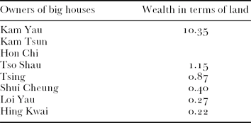
Grand-style houses formed another index of relative wealth in the Wong lineage community. What we find is this (
Table 10):
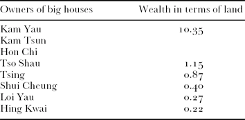
What we learn from this exercise is that landed people had big houses. This is not to say that the main part of their wealth was in land, but in village terms, landed property was substantial for them. But we can also see that some people with little land could still afford to live in sizeable residences. Their money would have been earned outside the village community, for instance, from overseas work or trade.
Still another feature of local habitation is that a small cluster of houses in Lung Tseng Tau was owned by Wong people. These were five buildings, four of them situated at the eastern end of the main village and close to the entrance of the Tung Chung Fort. The fifth was a small house found at the back of the village, beside the wall of the fortress. The owners of these four houses inside Lung Tseng Tau were all members of Segment C. One of the structures, at the very end of the front terrace, is directly annexed by another building, and the two seem to have formed one large unit. With one house in between there is a third house in the terrace. These four are all owned by Kam Yau, Kam Tsun and Hon Chi, and were probably once the property of the public officer Wai, who is said to have been an employee of the imperial Kowloon Submagistracy. Perhaps, the house in between was also at one time part of this cluster of buildings. The ordinary village house in the back terrace was owned by Shü Pai, Shü Yao and Kam Hing and may once have been the property of Wai's brother. This petty official may have preferred to stay close to the fortress for congenial company, but the brother is a more problematic figure; there is no clear reason why he should have lived in Lung Tseng Tau, unless he was somehow under the sway of his more influential (and no doubt rich) brother.
There is the further possibility that the cluster of Wong houses in Lung Tseng Tau indicates that Segment C remained residents of Lung Tseng Tau when the other Wongs moved out and Segments A and B established themselves at some distance in what was to become Wong Ka Wai. Only later did the Segment C people move into Wong Ka Wai, where they established themselves in the eastern sector, separated from the earlier settlers by a narrow lane. And yet, they maintained their houses in Lung Tseng Tau.
Finally, we should give some thought to the two large adjacent houses (D.D.3: 1961) that were situated on the other side of the Tung Chung road, away from Wong Ka Wai among the fields that slope down towards the beach. This type of settlement, a little removed from the village cluster itself, was traditionally associated with local leadership in that some distancing may have been necessary to demonstrate that the aspiring person did not directly speak for his own kinship community.Footnote 18 The owners in 1904 were Hon Chi, Kam Yau and Kam Tsun. It could have been built by Wai or Wai's son. Whether this was actually the case is not known. A more prosaic explanation for this isolated residence is that there was a lack of suitable land for large new buildings in the old village.
In addition, Houses D.D.1: 1959 and D.D.1: 1960 in the register are problematic in that they are not marked on the 1904 cadastral map. D.D.1: 1960 is described as a large house owned by Tso Shau. There is a much later entry, dated 1964, stating that compensation of HK$871 had been paid for this house. The likely story is that the land and house were reclaimed and the structure demolished by the Crown sometime just before 1904 to make way for the new Tung Chung road, but that the compensation (or its registration) was considerably delayed. Tso Shau died in 1911, and his successor Hi in 1920, so the amount should have been paid at a later date (in 1964, when there was a general enquiry into land questions?) to Tso Shau's grandsons Wah Yuk, Wah Hin and Wah Fuk. The house given number 1959 and owned by Kwai Fu may have experienced a similar fate—compensation of HK$436 was paid in 1964. Another house was a ‘new grant’ (D.D.3: 2319) given to Nam Yau in 1904. This is a narrow small house situated on the far side of the Tung Chung Fort, in the domain of the village of Sheung Ling Pei. What was the purpose of this new building is not known.
Threshing Floors
The threshing floors were spread among the fields. Significantly, they were used to mark the agglomeration of genealogical segments and branches. Estate 27 was a threshing floor, which was the corporate focus of Segment B. This segment received a similar expression in the threshing floor of Estate 25. Estate 21 marks a segment founded two ascending generations above the 1904 owners and was a single threshing floor. Tso Shau and Nam Yau had a common threshing floor as part of the larger Estate 17, which could have referred to a common ancestor three generations earlier. My hunch is that such threshing floors remained corporate property after a division of inherited property had taken place. It may be that the relatively unproductive character of this sort of land made it suitable for being set aside as trust land by persons who in other respects were in competition for one another. Furthermore, it is interesting to note that the double ownership of productive rice land and houses, generally understood as the criterion for village citizenship,Footnote 19 could be replaced by shares in a threshing floor in Wong Ka Wai. These cemented grounds were used for the drying and threshing of grain, and so connoted agriculture; they funnelled rice from the fields to the stoves of the village residencies. In this sense, threshing floors may have functioned as a symbolic shorthand, an imagery condensing and connoting both fields and houses.
Mortgages
The land records of 1904 do not indicate any mortgages where both mortgagor and mortgagee were of the local Wong lineage. This could mean that people preferred to go outside the kinship constellation to raise cash against security in land. This might also mean that if such transactions did occur within the lineage, they were not properly registered. It was noted by officials at the time that mortgages were very often made orally and never certified.Footnote 20 I have found only one entry where a Wong man was a mortgagor, but eighteen entries where Wong people appear as mortgagees. The sole case of a Wong mortgagor was Hin Yin, whose small Estate 4 of 0.17 acres of paddy was subject to Chinese Customary Mortgage and was held as security by two men, Lei To Sheng and Lei Yau. If these two men were locals, they may have been of the Lei lineage in Lam Che—but this is speculation.
Chan Yung Fu and Chan Fu Shing of the village of Lung Tseng Tau mortgaged six lots of paddy and one field of dry cultivation of 0.62 acres together. Mortgagees were the owners of Estate 22. No sum of money is mentioned, nor is any redemption, though, since the fields were later inherited without further entries in the land records, it is likely either that the money was paid back or that the transaction was ignored or forgotten. At any rate, these fields never passed into Wong hands. Chan Yung Kwai of Lung Tseng Tau mortgaged three fields of paddy (0.39 acres) to Estate 28. They were redeemed in 1908. Hoa Hi Sheung and Hoa Yung Fat of Ma Wan mortgaged three paddy fields (0.21 acres) to Wong Hon Chi; the loan was for the sum of HK$15. These Ma Wan men took another loan of HK$9 from Wong Kam Ling, with 0.20 acres of rice land as security. Both mortgages were redeemed in 1912.
In addition, the record reveals that mortgagees could be both land corporations and private persons. Hon Chi is an interesting name in this connection as he himself had no private landed property at all. His money must have come from some other business. It is also noteworthy that all mortgages were redeemed as far as can be judged. This circumstance contradicts a generally held belief that once a Chinese peasant mortgaged his land, this was lost to him. Again, there remains the possibility that a number of such transactions were never put on record, but no addition to the body of Wong land seem to have occurred as a result of unpaid mortgages. Whether this is a typical case or not cannot be discovered on the basis of the present corpus of data. It does not seem likely that Wong Ka Wai men owned land in other villages in the area as a result of unpaid mortgages. A brief survey of people named Wong in the Tung Chung Valley shows no connections with Wong Ka Wai.
Discussion
This study has allowed us to make a number of observations on the pragmatic significance of landed property in a coastal village in Guangdong in the late Qing times. Land was certainly a ‘real world thing’ and a main source of physical survival. The village of Wong Ka Wai was situated inside the double-cropping rice area, and most fields were planted with wet rice with the help of simple irrigation techniques. Still, most villagers had very small holdings. The study reveals just how much people must have been dependent on other means of livelihood. What these originally were is hard to say, but around 1904, people could have found employment or business in the newly emerging cities of Victoria and Kowloon. There were also other options, and we know of at least one villager who was a resident of Nam Tau in Chinese territory. Others, no doubt, were seamen travelling around the globe, and yet others overseas residents—one Wong Ka Wai man died in New York City. We cannot know the degree of absenteeism that prevailed here at the time, but as there were so many small holdings, these lots of land cannot have supported their owners except very marginally. It is possible that they provided small incomes from being let to neighbours in the village who had more viable areas under cultivation. What is noteworthy here is that the owners clung to their landed possessions, rather than opting to sell off their economically insignificant lots.
One reason for this may have been that the male owners maintained families in the village and so needed houses, and perhaps some small fields would have provided work for their wives and children. One tiny lot could have formed the nucleus of a larger cluster of rented land. What is more, corporately held property seems to have remained important as pointers in the terrain, demarcating kinship clusters of a common agnatic ascent order. It is true that the lots of various holdings were widely scattered in the agricultural landscape. For instance, the ancestral land going with the lineage hall was situated at quite a distance from the latter building. But what matters here is the abstract reckoning of land. Through the various corporate holdings, people could orientate their individual belongings within the lineage village framework. Also, through a series of corporate holdings, people were connected into a lineage. They were local citizens in that they had access to private and corporate land, and rights in the land of the main ancestral trust, combined with ownership in private houses and membership in the common ancestral hall vested in the name of the village founder.Footnote 21 Through the ownership in land, they were able to keep track of the increasingly wider spans of kinship that ultimately joined all local Wong people into one group of descendants. Land ownership was a political document that functioned as a charter of belonging in place of, or perhaps complementing, written genealogies. The ancestral hall, with only one common memorial tablet in Hakka fashion, would not have given much guidance as to the individual's place within the community. Land formed a very powerful discursive idiom in terms of which belonging and positioning for individuals in a union were outlined under the influence of an agnatic grammar of kinship.
In a more general perspective, one might hypothesise that this articulation of individual belonging through the ownership of land is what we should focus on when we turn to considering the long-term social construction and evolution of the very grand lineage organisations that frequently emerged in southeastern China, the Yangzi Valley and elsewhere in the south. As topoi in an iconic code, ‘rice’ and ‘rice land’ were loaded with archetypal meanings, which were carried over as ‘tacit understandings’ into the discursive use of land in an ongoing negotiation of belonging. Furthermore, games of power could draw on the pragmatics of land and belonging with great success because of such implicit iconic motifs. The simple threshing floor might easily develop into large tracts of corporate rice land. The editing of genealogical texts was for the few and presupposed that some members of a patronymic lineage were educated and able to use the characters of the written language. Genealogical records were clearly political instruments for tracing and computing ancestry as a network of relations. Computing ancestry was an activity with referents in the nodes provided by an idealized time—a flow of generations, rather than factual events—and thus was also suitable for strategic elaboration and opportune inclusion or exclusion. The truths of the genealogies were, by and large, the truths of the compilers. Wherever such compilations occurred, the tracking and elaboration of ascent by way of memorial tablets in ancestral halls fulfilled a similar function in the making of lineages.
When used as the main idiom for the expression of belonging, land did not lend itself so easily to machination, although land disputes—as in Wong Ka Wai in later years—prove that attempts were made. It is my hypothesis that land formed the essential topic in a social discourse that provided the opportunity for people in small settlements with few resources to band together and form continuous kinship constellations; the rules for the succession to landed property and houses formed a most important grammar for organising the group over time and endowed it with the aesthetics of kinship decorum. Land must have been a main basic asset, and the idiom of land a medium, for any further pragmatic elaboration among more wealthy communities.
One particular feature of Wong Ka Wai was the uneven distribution of wealth among the Wong lineage's segments. One segment had nearly all the land, while the other two very little. Wealth in terms of land seems to have been accumulated by one particular man, a person who maintained contacts with imperial administrators and is said to have been an official of the imperial submagistracy of Kowloon City, a deputy agency of the San On (Xin'an) Magistracy with its main seat in Nam Tau (Nantou). What actual status this man had remains very obscure. One possible connection with officialdom was through the Tung Chung Fort, which, as we have seen, was near the village and where an imperial garrison was kept as part of the protection of the Pearl River Estuary.
It might be mentioned that there were several garrisons stationed in this area. The market town of Tai O, serving also Wong Ka Wai, had a military and naval yamen and a post with some thirty guards. Besides the Tung Chung Fort, there was a disused fortification at Fan Lau. Tung Chung had a garrison of about thirty. These posts had existed since before 1817, but gained new importance in suppressing piracy and looting in the wake of the British annexation of Hong Kong Island in 1841, and thus increasing trade in the area.Footnote 22 It is known that elders of the nearby villages made visits there,Footnote 23 and no doubt Wong Wai became involved with the army and could use these connections for his own benefit. It is possible that he bought land from his kinsmen, thus turning them into tenants or pushing them out of the sphere of agriculture; possibly, he also bought land from Lung Tseng Tau people. Wai may also have kept a relatively large house close to the fort. The growth of wealth inside Segment C surely had the potential for generating conflict and envy, but of this nothing is known.
Each local community in the coastal landscape had its own special features and characteristics, and we cannot say what constituted a typical southern Chinese village. Comparison between settlements is a matter of tracing the spread of family resemblances. And yet, it may be worthwhile to juxtapose various bodies of ethnographic evidence—not in order to find out what was typical, but rather to achieve insights from the ever-present variation. It is through what is different that we may hope to grasp what unites. This particularising study has been offered as a contribution to the wider knowledge of the ‘traditional’ social landscape in southern China.