

INTRODUCTION
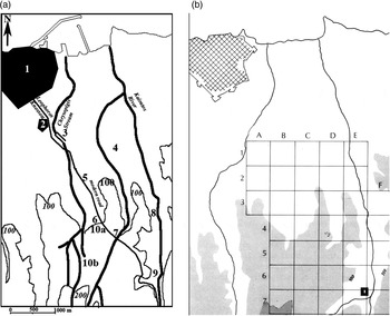
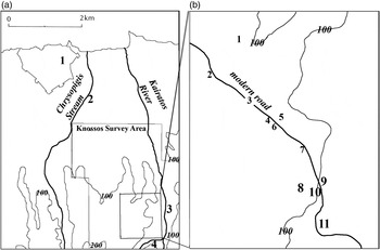
Four inscriptions of Hellenistic to Early Roman date were found in rescue excavations undertaken during the construction of public housing, at the location Stani near the Bedevi Kamara, east of Leophoros Knossou in the suburbs of modern Aghios Ioannis Herakliou (Fig. 1 no. 3; Fig. 2).Footnote 1
Heraklion and Knossos area. (a): 1) Heraklion; 2) Aghios Constantinos; 3) Bedevi; 4) Isopata; 5) Aghios Ioannis; 6) Ambelokipi (Teke); 7) Venizelion Hospital; 8) Zapher Papoura; 9) Palace of Minos; 10a) Palio/Ano Fortetsa; 10b) Nea/Kato Fortetsa. Based on Spanakis Reference Spanakis1964, map between 128 and 129. (b): Comparable area from Hood and Smyth Reference Hood and Smyth1981, fig. 1.

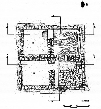
Structure excavated at Bedevi (Ioannidou-Karetsou Reference Ioannidou-Karetsou1976, 358; Reference Ioannidou-Karetsou2008, 68 fig. 46a).

These four inscriptions constitute an intriguing group as they provide evidence of an area between Knossos and Heraklion that featured a possible rural installation, a sepulchral site and private worship of Artemis, as well as a point between ancient Heraklion and Knossos where a Roman road crossed the Chrysopigis stream (Ioannidou-Karetsou Reference Ioannidou-Karetsou2008, 72). This area is identified here as ‘greater Knossos’, as it is most comparable to a Roman suburbium, a transitional space in the movement of goods and people that featured a diverse range of activities including water systems, burials, religious activities and roads.Footnote 2 The structure in which they were found – closer to Heraklion than to Knossos – is now covered over, but was almost parallel to Leophoros Knossou.Footnote 3 These four inscriptions provide new evidence for the nature of this area and for the northern road connections of Roman Knossos, particularly the road that linked Knossos with its harbour at Heraklion.
THE ARCHAEOLOGICAL AND TOPOGRAPHICAL CONTEXT
These four inscriptions – and a bronze coin of the first century ad – were found in Roman fill above and inside a square underground building of Late Hellenistic and then Roman times, one that had been constructed of poros ashlar blocks preserved to an unspecified but apparently significant height (Alexiou Reference Alexiou1975, 199; Ioannidou-Karetsou Reference Ioannidou-Karetsou1976, 357; Reference Ioannidou-Karetsou2008, 67; Fig. 2). In its first phase the building may have been a cistern, with a floor layered to provide waterproofing and a wooden staircase giving access from the ceiling or roof at the north wall (Ioannidou-Karetsou Reference Ioannidou-Karetsou1976, 357; Reference Ioannidou-Karetsou2008, 67). In its second phase the floor was coated with plaster, the bottom step of the staircase was covered and a pit was left in the west side (in a corner of Room 4), perhaps for the cleaning of the cistern (Ioannidou-Karetsou Reference Ioannidou-Karetsou1976, 357; Reference Ioannidou-Karetsou2008, 67). In its third and final phase, four internal walls divided the square building evenly into four rooms – numbered from the northwest corner clockwise to the southwest – linked by small openings that were framed by door jambs and thresholds lying on the floor of the second phase (Ioannidou-Karetsou Reference Ioannidou-Karetsou1976, 357–8; Reference Ioannidou-Karetsou2008, 67). The pit and staircase of the earlier phases continued to be used (Ioannidou-Karetsou Reference Ioannidou-Karetsou1976, 358; Reference Ioannidou-Karetsou2008, 67). Nearly all the pottery from the building – cups and other vessels as well as lamps – was gathered in Room 1 in the north-west corner of the building (Ioannidou-Karetsou Reference Ioannidou-Karetsou1976, 358; Reference Ioannidou-Karetsou2008, 67–9). In the same room bones of animals but not humans were found, as well as the bronze coin noted above (Ioannidou-Karetsou Reference Ioannidou-Karetsou1976, 358; Reference Ioannidou-Karetsou2008, 69). The building had a tile roof, to judge from the number of flat tiles found in upper layers of the fill (Ioannidou-Karetsou Reference Ioannidou-Karetsou1976, 358; Reference Ioannidou-Karetsou2008, 69). It is difficult to determine the final function of the building but it is not likely to have been sepulchral or religious (Ioannidou-Karetsou Reference Ioannidou-Karetsou2008, 67).
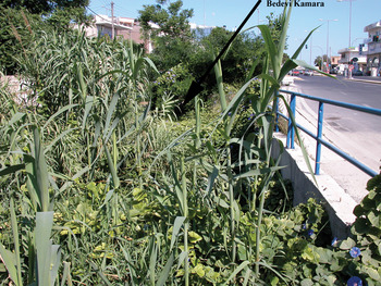
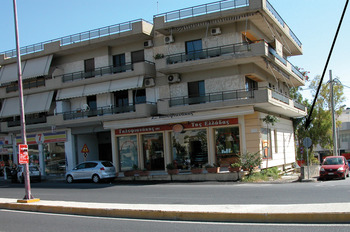
The bridge that gives its name to the excavation was called τοῦ Πεντεβῆ ἡ Καμάρα and it was – and still is – west of Leophoros Knossou, some 100 m to the north of the new National Road, where it crosses over Leophoros Knossou (Kritzas, pers. comm.; Appendix; Fig. 1 no. 3; Fig. 3). The bridge is now filled up half or more under the modern street level, at the northern peak of a triangle of uncultivated earth with the stream in the middle, and can be seen only from the south (Kritzas, pers. comm.). The bed of the stream, with bullrushes, is still visible at the location Stani, near the intersection of Leophoros Knossou and the new National Road (Ioannidou-Karetsou Reference Ioannidou-Karetsou2008, 78), across from the Bedevi bridge (Fig. 4). The stream which the Bedevi bridge crosses, the modern Chrysopigis stream, was once called the Marulas after the suburban area where it emptied into the sea in Venetian times (Andriotis Reference Andriotis2006, 145; Appendix). Hood and Smyth show the stream (without name), whose headwaters lay northwest of Fortetsa – less than 2 km from Knossos – before they joined another stream running north to Ambelokipi (Teke) and west of Aghios Ioannis (Hood and Smyth Reference Hood and Smyth1981, 25 fig. 6 and fold-out map). The stream began at Fortetsa and ran northeastward via the Bedevi and Chrysopigi quarters of modern Heraklion to the sea, east of the Sabionara bastion of the Venetian walls of Candia (Ioannidou-Karetsou Reference Ioannidou-Karetsou2008, 78; Alexiou, pers. comm.).
Bedevi Kamara, taken from the south, along Leophoros Knossou. Photo: author.

Stani, taken from Bedevi Kamara, eastwards across Leophoros Knossou; arrow points to area of excavation. Photo: author.

The structure excavated at Bedevi Kamara is likely to have been water-related – at least in its first and second if not its third stages – given its proximity to a stream that was even more significant in antiquity than in modern times. The deepest part of the stream bed was about 5–6 m, and the ancient stream could have provided some quantity of water for inhabitants of the area in the Roman period (Alexiou, pers. comm.). We just may have the remains of a rural installation from the area of greater Knossos (cf. Fritzilas, forthcoming). The Bedevi Kamara and the location Stani lie just northwest of the Knossos Survey Area, whose section A1 barely touches the stream flowing towards Heraklion. This location was beyond the northernmost residential district of Roman Knossos, whose boundaries are indicated by the North Cemetery in the area of Ambelokipi and the necropolis at the modern Venizelion (Sweetman Reference Sweetman2010, 349 and 355). Rather it was in a location near the place where the Roman road between Knossos and Heraklion crossed the stream. For possible comparanda for our water-related structure we might look first to a built cistern excavated in eastern Aghios Ioannis, whose water source has not been found even though it is located along a dry stream near a western tributary of the Kairatos River (Bannou Reference Bannou, Livadiotti and Simiakaki2004, 881; Hood and Smyth Reference Hood and Smyth1981, 37 no. 41). We might also look to a fountain house excavated along a western branch of the Karteros River (Panagiotakis Reference Panagiotakis2005–6). It had a tile ceiling in its original phase and was then elaborated and associated with a deity, to combine the beauty of the countryside with the amenities of urban life (Panagiotakis Reference Panagiotakis2005–6, 101–3).
THE INSCRIPTIONS
1. Lid of a vessel, inscribed with the name Κύθ(ηρος?)
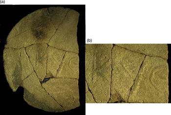
Heraklion Archaeological Museum, inv. no. P21828 (Fig. 5a–b). From Heraklion, found at Bedevi, in Room 1, group a1, 3 May 1976. This is the larger part of a clay disc, with an inscription in raised letters. Ten fragments were reassembled, with signs of burning visible in places on the upper surface and all over the lower (Ioannidou-Karetsou Reference Ioannidou-Karetsou2008, 69, where the photograph is printed upside down).
Lid of a vessel, inscribed with the name Kyth(eros?). (a): Inscribed clay lid; (b): Detail of inscription. Heraklion Archaeological Museum, inv. no. P21828. Photo: author.

Diameter 0.19 m, 80.5% preserved; maximum width 0.135 m, thickness 0.11 m. Clay light brownish-grey (M10YR 6/2), with no glaze. Pale yellow encrustations (M2.5 Y 8/4) are visible on the upper surface.
The inscription appears essentially centred, within a visible circle that may have been made by the potter's wheel. Letter heights 0.03 m (Κ, Θ), 0.035 m (Υ). The line of breakage cuts through Θ but the cross-bar is completely preserved.
Letter forms suggest a Roman rather than Hellenistic date, particularly the cursive Υ. Apices on the bar of Θ ensure that this letter is not a lunate Ε (Fig. 5b).
ΚΥΘ( ).
Κύθ(ηρος?).
This inscribed lid was found in Room 1 of the building excavated at Bedevi (see Fig. 2), where other ceramics of the second half of the first century bc and of the first century ad were found.Footnote 4 The raised letters appear to constitute an abbreviation for a name beginning with the letters Κυθ-. In the Greek world names beginning with these letters were likely to be theophoric names or else ethnics. At Hellenistic Lissos on Crete, Κυθήριος might be an ethnic rather than a personal name (Fraser and Matthews Reference Fraser and Matthews1987, 278). Elsewhere in the Aegean Islands personal names beginning with these letters include Κύθηρος and Κύθαινα (Fraser and Matthews Reference Fraser and Matthews1987, 278, from Thera and Rhodes). Κύθηρος and Κυθήριος are attested at Athens and in Boeotia (Osborne and Byrne Reference Osborne and Byrne1994, 276; Fraser and Matthews Reference Fraser and Matthews2000, 251), while the feminine Κυθηρία is recorded in Thessaly and Bithynia (Fraser and Matthews Reference Fraser and Matthews2000, 251; Corsten Reference Corsten2010, 260). The feminine Κυθέρη is attested in Bithynia (Corsten Reference Corsten2010, 260), and the name Κύθης(?) in Macedonia (Fraser and Matthews Reference Fraser and Matthews2005, 204).
In the Roman world such Greek personal names could become cognomina that were appropriate for men or women of servile or libertine status. It is very tempting to identify the person named on this inscribed lid as Kytheros, a known duumvir of Roman Knossos; the name Κύθηρος was Latinised as Cytherus on two emissions of coinage that name a colonial duumvir, one before ad 48 and the other between ad 48 and 54.Footnote 5 Aeschinus Caes. L. was another duumvir of libertine status at Knossos where, as at Corinth, freedmen were eligible for magistracies.Footnote 6 Among Greek personal names preserved in Italian Campania – with which Knossos had particular connections (Bowsky Reference Bowsky2002) – Κύθερος, Κύθηρα and Κυθηρίς are names recorded at Pompeii, while Κυθηρία is attested at Puteoli.Footnote 7 In the Roman world this was a name derived from an epithet of Aphrodite or (for women) from the name of a hetaira (Solin Reference Solin1982, 257 and 358; Solin Reference Solin1996, 263).
The name Kytheros just may have been borne by the man whose name was abbreviated on the lid of the storage vessel at Bedevi, and by the Knossian duumvir. The fact that the letters on the lid are raised indicates that the inscription was produced before firing, by something like a mould or stamp (Kritzas, pers. comm.). We can note that at Heraklion there was an amphora production facility whose terminus ante quem is provided by a bronze coin dated before ad 48.Footnote 8 Tantalisingly enough, the coin that provides this terminus ante quem is one that records the first Knossian duumvirate of Kytheros. This is not to say that the storage vessel was stamped with a magistrate's name, but that Kytheros' name could have been stamped on the lid of a vessel produced at the amphora production facility of Heraklion, where amphora supports, bowls, flat tiles and cover joints were also produced (Marangou-Lerat Reference Marangou-Lerat1995, 44).
2. A sepulchral inscription for Κύρσαμος Σοάρχω
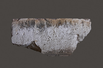
Heraklion Archaeological Museum, Epigraphical Collection, inv. no. E355 (Fig. 6). From Heraklion, collected at Bedevi during digging, 6 December 1975 (Alexiou Reference Alexiou1975, 199–201; Ioannidou-Karetsou Reference Ioannidou-Karetsou1976, 357–8; Reference Ioannidou-Karetsou2008, 73).
Sepulchral inscription for Κύρσαμος Σοάρχω. Heraklion Archaeological Museum, inv. no. E355. Photo: Y. Papadakis. Courtesy of A. Ioannidou-Karetsou.

The top, left and right margins are preserved, the bottom is broken left and right. The back side is roughly worked. The stone has apparently been reused, to judge from the back side and cutting as well as remains of mortar on the inscribed surface. Height 0.40 m; width 0.84 m at top, 0.34 m at bottom; depth 0.24 m.
The inscription is not perfectly centred on the stone as preserved, but may have been centred before reuse. Line 1 begins 0.215 m from the left margin, ends 0.17 m from the right; line 2 begins 0.27 m from the left margin, ends 0.205 m from the right.
The letter height is 0.04 m in both lines; the space between lines 1 and 2 is 0.01 m. Lettering has apices. Letter forms include Α with broken bar, Μ with diagonals that cross to form an apex, Ο and Ω rounded, Ρ with high small round loop, Σ with straight broad horizontals, Υ and Χ very open, Ω with pronounced straight horizontals. The initial letter (K) is difficult to distinguish but visible apices suggest a vertical stroke on the left, as well as upper and lower diagonal strokes on the right.
The date is Hellenistic.Footnote 9
ḲΥΡΣΑΜΟΣ
ΣΟΑΡΧΩ
Ḳύρσαμος
Σοάρχω
The name Kyrsamos is attested not only for the first time in Crete (Ioannidou-Karetsou Reference Ioannidou-Karetsou2008, 73) but for the first time in the onomastics of ancient Greece.Footnote 10 The name element Κυρσ- is attested in the names Κύρσας and Κυρσίλος, from the end of the fifth century bc to the first century bc. In Thrace, the name Κύρσας is attested three times in a fourth–third century bc inscription from Apollonia-Sozopolis (Fraser and Matthews Reference Fraser and Matthews2005, 205) and once on a coin of the Greek colony of Olbia that is dated c.225–200 bc (Fraser and Matthews Reference Fraser and Matthews2005, 205). The personal name Κυρσίλος is attested at Thessalian Pharsalos in the mid-fourth century bc, for a Pheraian (Fraser and Matthews Reference Fraser and Matthews2000, 251). At Pherai and Delphi Κυρσίλος was the name of two men of high status.Footnote 11 The name Κυρσίλος is also attested at Athens (Osborne and Byrne Reference Osborne and Byrne1994, 277; Kirchner Reference Kirchner1901–3, vol. 1 no. 8949; Traill Reference Traill2001, 643 no. 588935). In Athens the name Κύρσας was borne by a slave in 405 bc (Osborne and Byrne Reference Osborne and Byrne1994, 342; Fragiadakis Reference Fragiadakis1988, 356 no. 428). The personal name Κυρσίλος appears twice for a Naxian named in a first century bc civic decree from the island of Syros (Fraser and Matthews Reference Fraser and Matthews1987, 279).
The name Soarchos is specific to central Crete and its elite (Paluchowski Reference Paluchowski2005, 51–5 and 94; Paluchowski Reference Paluchowski2008, 308–9). At Axos in the fourth century bc an inscription concerning the Pythion names Soarchos among other members of the local elite (Supplementum Epigraphicum Graecum 23 [1968], no. 566). Soarchos is, moreover, a name particularly associated with the Gortynian elite from the third century bc to the first century ad.Footnote 12 Gortynians of elite status named Soarchos also appear at the Asklepieion in its port Lebena from the second to first centuries bc (Guarducci Reference Guarducci1935, 156 no. 5, 160 no. 9, 170–1 no. 21, 175 no. 38). Melambes, inland from Sulia on the west coast of the Mesara, preserves the name Soarchos in a funerary inscription of the second–first century bc and in an inscription concerning the rebuilding of a temple in the third–second centuries bc (Supplementum Epigraphicum Graecum 28 [1978], nos. 753 and 755). A bilingual inscription of the first century from Priansos – on the south coast east of Gortyn – preserves the name Soarchos in the patronymic of a protokosmos (Guarducci Reference Guarducci1935, 283 no. 5).
It is difficult to account for the pairing of a rare name like Kyrsamos – possibly of Thessalian origin – and an elite Cretan name like Soarchos in the area of greater Knossos, unless there was a military context that might bring the son of a Gortynian there. It is tempting to think that it was mercenary service that brought a name of Thessalian origin to Crete and Gortyn in particular.Footnote 13 On Crete in the Hellenistic period the shifting relationship between Gortyn and Knossos provides intriguing possibilities for ways one or both of these men might have come to be in the region north of Knossos. We can note that in times of co-operation and alliance between Knossos and Gortyn – such as the War of Lyttos (222–218 bc), or the joint efforts against Kydonia (189 bc) and Rhaukos (166 bc) – an official context might account for this sepulchral inscription (Chaniotis Reference Chaniotis2005, 9–11). In times of enmity – in particular their conflict over Apollonia, northwest of Knossos, after 170 bc and until 168 bc – we could think of a military context (Chaniotis Reference Chaniotis2005, 11; Chaniotis Reference Chaniotis1996, 289–301 nos. 43–5).
3. A private dedication to Artemis, from Δια{ι}δούμενος Θετταλίσκου
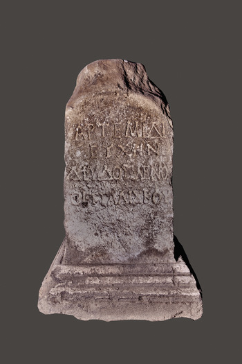
Heraklion Archaeological Museum, Epigraphical Collection, inv. no. E354 (Fig. 7). From Heraklion, collected at Bedevi during digging, 6 December 1975 (Alexiou Reference Alexiou1975, 199–201; Ioannidou-Karetsou Reference Ioannidou-Karetsou1976, 357–8; Reference Ioannidou-Karetsou2008, 70–1).
Private dedication to Artemis, from Δια{ι}δούμενος Θετταλίσκου. Heraklion Archaeological Museum, inv. no. E354. Photo: Y. Papadakis. Courtesy of A. Ioannidou-Karetsou.

The base and body of the altar are preserved on all sides despite some breakage on the left side. The pediment is composed of two steps barely preserved on the front side, somewhat more on the back, but not at all on left and right. The uninscribed sides are unworked and show traces of tooling.
The total height is 0.76 m including base and pediment; the base height 0.16 m; the pediment height 0.11 in front, 0.12 m at back; the field of inscription height 0.49 m. Width 0.48 m at base, 0.32 m at field of inscription. The width of the pediment is not preserved. The depth is 0.42 m at the base, 0.27 m at the field of inscription, 0.31 m at the pediment.
The inscription begins 0.08 m from the top of the field of the inscription, and ends 0.18 m from the bottom. The inscription is not perfectly centred in the field. Line 1 begins 0.03 m from the left margin, and ends 0.01 m from the right; line 2 begins 0.07 m from the left margin, and ends 0.04 m from the right; line 3 begins at the left margin, is crowded, and the final Σ (half as wide as the Σ in the next line) is barely accommodated at the right margin; line 5 begins 0.014 m from the left margin, final Υ is inscribed on the right margin.
Letter height is 0.04 m in all lines. The interval between lines is 0.01 m (lines 1–2), or 0.03 m (lines 2–3, and 3–4). Lettering has prominent apices. Letter forms include Α with broken bar, Δ with small vertical stroke atop peak, Θ with bar, Κ with short diagonals, Μ with central strokes that reach line of inscription, Ν with incomplete second vertical in line 2, Ρ with high round loop. The spelling Δια{ι}δούμενος, seen by Alexiou (Reference Alexiou1975, 199), is clearer in photographs than to the naked eye. The space of 0.02 m between the right diagonal of Α and the left diagonal of Δ can certainly accommodate this slender letter, particularly given the crowding that is increasingly visible in this line.
The date is first century ad, to judge from lettering and the name Thettaliskos, shared with M. Claudius Thettaliskos.Footnote 14
ΑΡΤΕΜΙΔΙ
ΕΥΧΗΝ
ΔΙΑ{Ι}ΔΟΥΜΕΝΟ
ΘΕΤΤΑΛΙΣΚΟΥ
Ἀρτέμιδι
εὐχήν
Δια{ι}δούμενο
Θετταλίσκου
Artemis was worshipped – mostly publicly but here privately – southwest, west, northeast, and now north of Knossos. The new place where Artemis was worshipped north of Knossos cannot be identified with the shrine of Artemis Skopelitis, attested in a second century bc inscription and located southwest of Knossos, on the rocky height now occupied by the village of Ano Fortetsa (Hood and Smyth Reference Hood and Smyth1981, 42 no. 106; Ioannidou-Karetsou Reference Ioannidou-Karetsou2008, 71; Fig. 1 no. 10a). To the west of Knossos an Artemision lay on its border with Tylissos, to judge from the text of a fifth century bc treaty between Knossos, Tylissos, and Argos (Ioannidou-Karetsou Reference Ioannidou-Karetsou2008, 72; Sporn Reference Sporn2002, 116–7; Guarducci Reference Guarducci1935, 57 no. 4 b, 7). To the northeast of Knossos Artemis was worshipped together with Eileithyia at Amnisos (Chaniotis Reference Chaniotis and Schäfer1992, 85–6).
The only evidence for private worship of Artemis is provided by this inscribed altar, found south of Heraklion (Sporn Reference Sporn2002, 116–7). This altar might well have been dedicated to Artemis as the πότνια θηρῶν (Ioannidou-Karetsou Reference Ioannidou-Karetsou2008, 72) or as a water-giving goddess, protector of plant growth (Chaniotis Reference Chaniotis and Schäfer1992, 85). In the latter capacity her cult places tended to be located on the sea or near pools and ponds, swampy lowlands with luxuriant plant growth, springs, brooks and rivers (Chaniotis Reference Chaniotis and Schäfer1992, 85). West of Knossos, at Mikra Anogeia, an altar and shrine of Artemis Physis has recently been located near a water course (Karamaliki Reference Karamaliki2011). An inscription from Pyrgi of Eleutherna may preserve evidence of the cult of Artemis Agrotera, hitherto unattested on Crete (Kalpaxis and Petropoulou Reference Kalpaxis and Petropoulou1988–9, 127–9). A cult place along the water course that ran from Fortetsa through Bedevi to the sea east of Heraklion would be just the sort of place for Dia{i}doumenos' dedication to Artemis as a water-giving goddess.
Dia{i}doumenos ought to be the son of Thettaliskos, named in the genitive in the dedication to Artemis. His is now the second name with a possible Thessalian connection to be found inland from Heraklion. Diadoumenos is a Greek personal name derived from the verb διαδέω, and originally meant ‘binding’ (Liddell, Scott and Jones Reference Liddell, Scott and Jones1996, s.v. διαδέω). The name is well attested across the Greek world, including once for a priest at Thessalian Pharsalos in the first century bc to the first century ad (Kern Reference Kern1908, no. 402, b = Decourt Reference Decourt1995, no. 96, B). In the Roman world it was particularly common as a name for slaves and freedmen, and ironically meant either ‘dressed, clothed’ or ‘naked, nude’.Footnote 15 The earliest occurrences of this name appear to date from the first century bc to the first century ad, at Pompeii.Footnote 16 It is most common in southern Italy – particularly Campania – and Sicily (Fraser and Matthews Reference Fraser and Matthews1997, 124), as well as in coastal Asia Minor (Corsten Reference Corsten2010, 128). It is also attested on Amorgos and Thasos, at Athens and Sparta, in Boeotia and Thessaly, Macedonia, Sarmatia and Thrace.Footnote 17
Thettaliskos is the less common of two spellings of a Greek personal name that refers to Thessaly or a Thessalian. It is intriguing indeed that in this area of greater Knossos there are now three names with possible Thessalian connections: Kyrsamos, Dia{i}doumenos, and Thettaliskos. In the Greek world names that begin with the letters Θεττ- are less common than those that begin with Θεσσ-: Θετταλός on Keos; Θετταλή, Θετταλία, and Θετταλός in Attica; and Θετταλή and Θετταλία in Boeotia (Fraser and Matthews Reference Fraser and Matthews1987, 220; Osborne and Byrne Reference Osborne and Byrne1994, 224; Fraser and Matthews Reference Fraser and Matthews2000, 196). The name Θεσσαλίσκος was borne by a Theban sent on an embassy to Darius sometime before 335 bc, captured after the battle of Issos, and released by Alexander the Great (Fraser and Matthews Reference Fraser and Matthews2000, 195). Of the Greek names attested in Rome – Thessalus, Thessale, Thessalius, Thessali[—] and Thettaliscus – Thessalus has been identified as a slave name (Solin Reference Solin1982, 575 and 1347; Solin Reference Solin1996, 364). Thettaliskos could also be the name of a freed slave, as ‘-iskos’ is a Greek name ending (Dornseiff and Hansen Reference Dornseiff and Hansen1978, 254) that means ‘little’, appropriate for a slave.
The cognomen Thettaliskos, with or without the praenomen and nomen M. Claudius, is part of an onomastic combination that appears to link Crete with Italian Campania and Latium, and particularly with the Cretan wine trade. Kritzas (Reference Kritzas, Carinci, Cucuzza, Militello and Palio2011, 483–4) argues that, depending on the presence or absence of the praenomen and nomen M. Claudius, we cannot be sure that the Thettaliskos named at Bedevi is the same man as the M. Claudius Thettaliskos named at Karnari, or that the latter is connected with the Thettaliskos named on the Cretan amphora found at Pompeii. We still might be able to connect the Thettaliskos named at Bedevi – albeit without praenomen or nomen – with (1) M. Claudius Thettaliskos named south of Knossos at Karnari in the so-called Capuan lands; (2) (M. Claudius) Thettaliskos, a wealthy freedman of M. Claudius Marcellus Aeserninus (Groag et al. Reference Groag, Stein, Petersen and Wachtel1933–2009 vol. 2, no. 928); (3) M. Claudius Thettaliskos, named at both Campanian Portici and Rome; and (4) Thettaliskos, named on a Cretan amphora transported to Pompeii. First, the cognomen Thettaliskos was borne by M. Claudius Thettaliskos, named in an inscription discovered south of Knossos at Karnari, in the lands given by Augustus to the Italian city of Capua.Footnote 18 There he appears to have been a landowner himself (De Caro Reference De Caro1992–3, 312), whose slave Soteridas made a dedication to the Kouretes as the protectors of pastoral interests (Supplementum Epigraphicum Graecum 56 [2006], no. 1057; Kritzas Reference Kritzas, Carinci, Cucuzza, Militello and Palio2011). Secondly, Kritzas identifies M. Claudius Thettaliskos of Karnari most securely with M. Claudius Marcellus Aeserninus' wealthy freedman, (M. Claudius) Thettaliscus, who brought a specimen of Platanus sempervirens from Crete to Italy in the reign of Claudius (Pliny, Naturalis Historia 12.12; Supplementum Epigraphicum Graecum 56 [2006], no. 1057; Kritzas Reference Kritzas, Carinci, Cucuzza, Militello and Palio2011, 484; Supplementum Epigraphicum Graecum 57 [2007], no. 845 ter). Thirdly, at Portici in the territory of nearby Herculaneum a lead pipe preserves the name of M. Claud(ius) Thettal(iscus), apparently the same freedman of M. Claudius Marcellus Aeserninus, who owned a suburban villa there.Footnote 19 And in Rome an inscription names M. Claudius Thettaliskos as the owner of the slave Serenus.Footnote 20 Fourthly, the cognomen Thettaliskos is further borne by a man whose name appears in the dative on a Cretan wine amphora that was apparently shipped to him at Pompeii in ad 59.Footnote 21 In inscriptions from Crete or on another Cretan amphora at least two other M. Claudii are known: M. Claudius Charmosynos Pratoneikos, named at Gortyn (Guarducci Reference Guarducci1950, no. 306 A), and M. C(laudius) Eury(tos), named on a Lyttian amphora found at Pompeii (Zangemeister et al., Reference Zangemeister, Schoene, Mau and Ciprotti1871–1970, no. 6471).
Kritzas identifies Soteridas – the slave named in the inscription from Cretan Karnari – as the probable οἰκονόμος/villicus of M. Claudius Thettaliskos (Supplementum Epigraphicum Graecum 56 [2006], no. 1057; Kritzas Reference Kritzas, Carinci, Cucuzza, Militello and Palio2011, 483). It is tempting to think that in the area of greater Knossos a Thettaliskos can be identified as the owner of land or even a villa or rural installation there. In the so-called Capuan lands Thettaliskos may have owned land or a rural installation that involved animal husbandry, while in the area of greater Knossos his land or rural installation featured a water-related structure (Marzano, forthcoming; Vlahogiannis, forthcoming).
4. An inscription on the road between Heraklion and Colonia Iulia Nobilis Cnosus
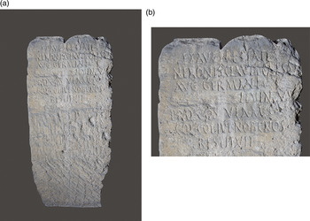
Heraklion Archaeological Museum, Epigraphical Collection, inv. no. E356 (Fig. 8). From Heraklion, collected in the location Bedevi during digging, 6 December 1975. Rectangular flat block of rough porolithos, broken at the upper right and the lower corners.Footnote 22
Inscription on the road between Heraklion and Colonia Iulia Nobilis Cnosus. (a): Inscribed block; (b): Detail of inscription. Heraklion Archaeological Museum, inv. no. E356. Photo Y. Papadakis. Courtesy of A. Ioannidou-Karetsou.

Height 1.31 m, width 0.62 m (0.46 m at bottom), depth 0.47 m. The upper right corner is broken off but reattached. The block may have been shaped, rather than broken at the bottom, for insertion in the ground. A cutting that may not be ancient, on the top surface, is not quite centred (0.24 m from the left margin, 0.27 m from the right), 0.03 m from the front edge; width 0.10 m, depth 0.09 m.
The inscription begins 0.09 m from the top, and ends 0.825 m from the bottom. The inscription is not centred but relatively well laid out, with line 7 nearly centred. The inscription begins 0.12 m (line 1) from the left margin, 0.08 m (lines 2–3), 0.07 m (lines 4–5), 0.08 m again (line 6), 0.18 m (line 7). The inscription extends to the right margin (lines 1–4), and ends 0.16 m before (line 5), 0.08 m before (line 6), 0.205 m before (line 7).
The letter height is 0.04 m in all lines, somewhat attenuated and cursive, with apices. In line 4 a rasura has obscured around 10 letters that should contain the abbreviated praenomen and full nomen of the proconsul, in the nominative. The second visible letter (‘I’) in this line has a lower apex and the third (‘L’) has a light lower stroke; the left vertical of N is interrupted, perhaps by a flaw in the stone. The space between N and V is wider than normal but contains no visible stroke and a possible apex may again be due to a flaw in the stone. Letter forms include Α with slightly diagonal bar and pronounced diagonal strokes, Β and P and R with small rounded upper loop, C and G and O somewhat attenuated, M with central strokes that reach the line of inscription and pronounced diagonals, N with pronounced diagonals, S particularly attenuated in line 6, V with diagonal left stroke and nearly vertical right stroke.
The date is mid-first century ad, given the name of the emperor Nero.
EXAVCTORITATE vacat
NERONISCLAUDICAESAR
AVG•GERMANICI vacat
rasura SILVINVS
5 PROCOS•VIAM vacat
COL•COL•IUL•NOBCNOS•
vvv RESTITVIT
Ex auctoritate vacat
Neronis Claudi Caesar(is)
Aug(usti) Germanici vacat
rasura Silvinus
5 proco(n)s(ul) viam vacat
col(onis) Col(oniae) Iul(iae) Nob(ilis) Cnos(i)
vvv restituit
This Latin inscription – unusual at Knossos as in all Crete – mentions the emperor Nero, on whose authority a proconsul restored the road for the colonists of Colonia Iulia Nobilis Cnosus (col(onis) Coloniae Iuliae Nobilis Cnosi).Footnote 23 No fewer than five inscriptions attest Nero's involvement in territorial arbitrations in central Crete. At Knossos the procurator P. Licinius Secundus restored to the colony five iugera given to Asklepios by Augustus and confirmed as the god's property by Claudius (Guarducci Reference Guarducci1935, 80 no. 49). At Pyranthus in the Mesara the proconsul L. Turpilius Dexter restored public lands to the Gortynians and several other lands occupied by private individuals (Guarducci Reference Guarducci1935, 288–9 no. 2). Another inscription from Pyranthus preserves only the phrase ex auc[toritate] Neron[is Claudi] Caes[aris Aug.] Ger[manici] (Guarducci Reference Guarducci1935, 289 no. 3). An inscription from Rhizenia – cut by the same hand as Guarducci Reference Guarducci1935, 289 no. 3 – probably also records a boundary established by Dexter (Guarducci Reference Guarducci1935, 302 no. 29). At Rhytion in the Mesara Nero appears to be named on a stele that gives the history of territorial arrangements involving a shrine of Zeus Skyllios (Guarducci Reference Guarducci1935, 304–5 no. 1).
Careful re-examination of the inscription shows that the proconsul's cognomen was not Livi(a)nus (Baldwin Reference Baldwin1983, 205–6) but Silvinus. Silvinus, also spelled Silvanus, was a very common cognomen (Kajanto Reference Kajanto1965, 36 and 162). Flower takes particular note of the unusual pattern in our inscription, in which Nero's name is preserved while the name of the proconsul is erased (Flower Reference Flower2006, 217). It appears even more peculiar that the praenomen and nomen were erased, but not the cognomen. Flower further notes the difference between such erasures from the late second century bc down to Hadrian – focused on individuals – and those from the post-Hadrianic period (Flower Reference Flower2006, xxi). If the name is that of a known senator, we should look for nomina attested by the reign of Nero, or under Nerva, Trajan and Hadrian at the latest. The variant Silvinus is attested for one senator during this period: Sextus Curvius Silvinus in the Augustan–Tiberian period (Groag et al. Reference Groag, Stein, Petersen and Wachtel1933–2009 vol. 7.2, 280 following no. 740), and one equestrian, P. Silvinus in the Julio-Claudian period (Groag et al. Reference Groag, Stein, Petersen and Wachtel1933–2009 vol. 7.2, 280 no. 740).Footnote 24 The senator Sextus Curvius Silvinus may have been the uncle or grandfather of two Sex. Curvii adopted by Cnaeus Domitius Afer in his will of ad 41 or 42, and so named Cn. Domitius Sex. f(ilius) Volt(inia tribu) Afer Titius Marcellus Curvius Lucanus (Groag et al. Reference Groag, Stein, Petersen and Wachtel1933–2009 vol. 3, 49–50 no. 152) and Tullus (Groag et al. Reference Groag, Stein, Petersen and Wachtel1933–2009 vol. 3, 52–3 no. 167). Between ad 42 and 59, however, their adoptive father took an active role in accusing and condemning their natural father Sextus Curvius Tullus (Groag et al. Reference Groag, Stein, Petersen and Wachtel1933–2009 vol. 2, 395 no. 1623) on grounds Pliny does not specify, with the result that his estate was confiscated (Pliny, Epistulae 8.18.5–6). It is just possible that an otherwise unknown homonymous descendant of Sex. Curvius Silvinus – whose praenomen and nomen would fill the 10 letter spaces available before the cognomen in our text – was proconsul of Creta-Cyrenae in the reign of Nero.
Even if we identify our proconsul as [Sex. Curvius] Silvinus, we still cannot explain the erasure of his praenomen and nomen. Thomasson (pers. comm.) estimates that the erasure of a proconsul's or legate's name is not unusual, but mainly involved governors of consular rank who had been involved in criminal actions against the emperor and/or state. If we again look to the period down to the reign of Hadrian, Thomasson's catalogue of provincial proconsuls and other officials suggests that it was the name or names of emperors, imperial procurators, or imperial legates – not proconsuls – that were removed from inscribed texts.Footnote 25
THE ROAD CONNECTIONS OF KNOSSOS
The inscriptions presented above increase our knowledge of the nature of the area of greater Knossos, including the stream and road that ran through it. Until the mid-1960s the road leading from Heraklion to Knossos, south of the old cemetery of Aghios Constantinos (Fig. 1 no. 2), was much narrower than now. Its eastern side was flanked by a deep ravine of the Chrysopigis stream, created by rain waters coming from the hills to the north of Mount Yuktas and reaching the sea to the east of Heraklion.Footnote 26 In the mid-1970s concrete tubes were installed in the bottom of the ravine, so that rain water could continue to be channelled to the sea, while the rest of the ravine was filled up in order to enlarge Leophoros Knossou (Kritzas, pers. comm.).
The Latin road inscription found at Bedevi (no. 4, above) is likely to have marked a crossing over the Chrysopigis stream (Fig. 1 no. 3) as it flowed from the area of Fortetsa (Fig. 1 no. 10a–b) to Heraklion. The Roman road apparently crossed the Chrysopigis stream in the area of Bedevi – possibly on a wooden crossing of which no trace is left (Alexiou, pers. comm.) – on its way from Knossos to Heraklion or vice versa. The Bedevi bridge that crosses the modern Chrysopigis stream first appeared on a map published at the end of the nineteenth century, just before the Cretan War of Independence (Mariani Reference Mariani1895, 221 fig. 46). Mariani's map – apparently drawn with the assistance of I. Hatzidakis, president of the Syllogos of Candia – shows not only the Chrysopigis stream but the principal road from Knossos and a bridge over it, southeast of the Christian cemetery at Aghios Constantinos (Mariani Reference Mariani1895, 221 fig. 46; Fig. 1 no. 2). Pendlebury noted that Knossos was connected with its harbour, east of modern Heraklion, by a road that passed close to the cemeteries of Zapher Papoura and Isopata (Pendlebury Reference Pendlebury1963, 12; Hood and Smyth Reference Hood and Smyth1981, 36 no. 36 and 34 nos. 1–2; Fig. 1 nos. 4 and 8).
Even though this road inscription was not found in situ but in fill above the Hellenistic-Roman building excavated at Bedevi, it should have come from nearby and so can suggest a point along the Knossos–Heraklion route that is considerably further north than any identified to date (Fig. 9a no. 2). Parts of the ancient Roman road of Knossos had already been found as far north as the Venizelion Hospital (Fig. 1 no. 7) and as far south as the Vlychia stream, where a Roman bridge took the ancient traveller toward Archanes in the so-called Capuan lands (Ioannidou-Karetsou Reference Ioannidou-Karetsou2008, 73; Fig. 9a no. 4). In the northern reaches of the Knossos Survey Area, evidence for the Roman road west of the Venizelion supports S. Paton's argument that the road is likely to have run along a route parallel to the main axis of the Civil Basilica – roughly on the 100 m contour – rather than veering northwest at the gate of the Villa Ariadne and then cutting through the middle of the Roman theatre (Paton, pers. comm.).
Traces of the Roman road between Heraklion and Knossos. (a): 1) Heraklion; 2) Bedevi Kamara; 3) Kairatos bridge; 4) Vlychia bridge. (b): 1) Knossos Paediatric Clinic; 2) Evans; 3) Roman Theatre; 4) Knossos 2000; 5) Civil Basilica; 6) Villa Dionysos; 7) Villa Ariadne; 8) Little Palace North; 9) Royal Road; 10) Mathioudakis plot; 11) bridge pier or gateway at Vlychia bridge. Based on Hood and Smyth Reference Hood and Smyth1981, fig. 1; Marangou-Lerat Reference Marangou-Lerat1995, 41 fig. 6; Ioannidou-Karetsou Reference Ioannidou-Karetsou2008, 60–1; Sweetman Reference Sweetman2010, 343 fig. 3.

In the north Knossos Valley Sweetman has identified a residential area for an enclave of Italian settlers, where part of a cobbled road and drain were found in rescue excavations at the Knossos Paediatric Clinic, on the west side of the Venizelion (Sweetman Reference Sweetman2010, 348–9; Fig. 9b no. 1). That this north–south road ran west of the Venizelion is confirmed by the remains of Roman necropoleis at the North Cemetery as well as the cemeteries recently excavated in the Venizelion area (Ioannidou-Karetsou Reference Ioannidou-Karetsou2008, 74; Grammatikaki Reference Grammatikaki, Cadogan, Hatzaki and Vasilakis2004). Evans' note of traces of a road south of the Venizelion, just beyond the point where the modern road crossed the stream that formed the boundary of the city in Roman times, just might belong to an east–west road rather than the one that ran south from Heraklion (Hood and Smyth Reference Hood and Smyth1981, 15 and 39 no. 69; Fig. 9b no. 2). The Knossos 2000 Project found parts of the main Roman road west of the modern road in two areas between the Roman theatre (Fig. 9b no. 3) and the Villa Ariadne (Fig. 9b no. 7), at a location probably across the Roman road from the forum and possibly marking an east–west intersecting road (French Reference French1993–4, 75; Tomlinson Reference Tomlinson1995–6, 42; Fig. 9b no. 4).
In the central Knossos Valley, where Sweetman has located the civic centre and a prestige residential area, rescue excavations uncovered a substantial east–west road construction south of the Civil Basilica, one that may also run along south of the Villa Dionysos (Sweetman Reference Sweetman2010, 350; Fig. 9b nos. 5–6). This east–west road just may suggest the intersection of the colony's cardo maximus and decumanus maximus, which ought to have met at the forum. Further remains of the north–south Roman road have been found under the modern road that runs in front of the Villa Ariadne (Fig. 9b no. 7) and through the modern village of Knossos (Paton, pers. comm.; The British School at Athens, Annual Report of the Managing Committee for the Session 1992–1993, 21).
In the southern Knossos Valley, where Sweetman locates an area that mixed affluent residences with small-scale industry, rescue excavations revealed part of the road in the area of the Little Palace North – near the Unexplored Mansion – as well as a cobbled road surface extending to the north (Sweetman Reference Sweetman2010, 351–2; Fig. 9b no. 8). Another stretch of north–south Roman road perpendicular to the Minoan Royal Road was found by Warren (Reference Warren, Evely, Hughes-Brock and Momigliano1994, 191–2; Fig. 9b no. 9). Immediately west of the Mathioudakis Plot across the modern road from the Minoan Palace, evidence of the Roman road was revealed by tests in 1947 (Sweetman Reference Sweetman2010, 371; Hood and Smyth Reference Hood and Smyth1981, 50 no. 208; Fig. 9b no. 10). A monumental feature found in rescue excavations still further to the south may be the remains of a Roman bridge pier or other substantial feature at the southern gateway to the colony (Sweetman Reference Sweetman2010, 349–50; Fig. 9b no. 11). From there the road crossed the Vlychia stream, on the way to Archanes (Hood and Smyth Reference Hood and Smyth1981, 50 no. 204; Fig. 9a no. 4).
The Latin road inscription presented above provides new and tantalising evidence for the road connections of Knossos. The Roman road now marked much further to the north by this inscription – itself the result of rescue excavations – might not have been the main artery that connected the north central coast of Crete with the south, which ought to have been marked by milestones like those found near Eleutherna, Aptera and Kisamos (Tzifopoulos Reference Tzifopoulos, Livadiotti and Simiakaki2004; Bowsky and Niniou-Kindeli Reference Bowsky and Niniou-Kindeli2006). In the Roman period a bridge over the Kairatos could mark another route leading from Knossos to the north (Hood and Smyth Reference Hood and Smyth1981, 40 no. 81), in the direction of Amnisos and Chersonesos, with which Knossos is connected in the tabula Peutingeriana (Miller Reference Miller1964, 609). Another Roman bridge marks the crossing to Knossos' south, over the Vlychia stream (Hood and Smyth Reference Hood and Smyth1981, 50 no. 203–4), in the direction of Gortyn, with which Knossos is also connected in the tabula Peutingeriana (Miller Reference Miller1964, 610).
We now have evidence of a third Roman crossing, north of Knossos and over the Chrysopigis stream to connect Knossos with its port at Heraklion. The Latin road inscription presented above is more like those found in the chora of Hierapytna (Bowsky Reference Bowsky2006), which are associated with seasonal streams like the Chrysopigis stream of Fortetsa and Heraklion. The Hellenistic-Roman city of Heraklion was located on the eastern side of the modern city, just inside the Sabionara bastion to which the Chrysopigis stream flows (Ioannidou-Karetsou Reference Ioannidou-Karetsou2008, 60–1, figs. 36–7). As at Thessalian Pherai, the ancient road that connected Knossos with its harbour may have passed close to one or more rural installations (Doulgeri-Intzesiloglou and Arachoviti, forthcoming).
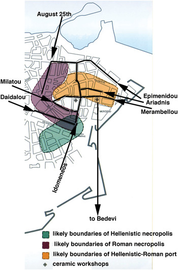
The Roman city of Heraklion (Fig. 10) is better known than ever, thanks to the efforts of Greek archaeologists from the early nineteenth century onwards, Greek-French study of an amphora production facility there, and Karetsou's synthesis of its hitherto unknown history. Beginning in the fourth or third century bc, a small natural harbour was organised at Heraklion, where there was a supply of clean, drinkable water for ships and a sandy beach for sailors and sellers alike outside the Sabionara bastion of the Venetian walls, where the Chrysopigis stream empties into the sea (Ioannidou-Karetsou Reference Ioannidou-Karetsou2008, 54). The modern coastline is around 1.5 m lower than in antiquity, with the result that the ancient port is to be found within modern Heraklion, in an area bounded by Idomeneus (or more likely Ariadne), Milatos, August 25th and possibly Merambello Streets (Ioannidou-Karetsou Reference Ioannidou-Karetsou2008, 61 figs. 37 and 63). The Roman necropolis lay in an area bounded by August 25th, Epimenides, Idomeneus and Daidalos Streets. Three ceramic workshops have been located, one a suburban amphora production facility located in an artisanal quarter of the city delimited by Idomeneus, Daidalos and Milatos Streets (Marangou-Lerat Reference Marangou-Lerat1995, 44; Ioannidou-Karetsou Reference Ioannidou-Karetsou2008, 66). Another has been identified in a part of the artisanal quarter defined by Idomeneus, Merambello and Arethousa Streets (Ioannidou-Karetsou Reference Ioannidou-Karetsou2008, 63). A third was most recently found on the north side of Merambello Street, east of Idomeneus Street (Ioannidou-Karetsou Reference Ioannidou-Karetsou2008, 91). This workshop was associated with a Roman villa that featured no fewer than six mosaics and yielded both local and imported ceramics from both Italy and the Greek East (Ioannidou-Karetsou Reference Ioannidou-Karetsou2008, 91). In this period the Roman city was economically vigorous, involved in the Cretan wine trade (Ioannidou-Karetsou Reference Ioannidou-Karetsou2008, 75 and 91) and supporting a well-appointed villa of unknown ownership. This villa, around 5 km from Knossos, probably lay on the road from Knossos to its port (Markoulaki Reference Markoulaki2008, 112). The Roman road could have reached the port, on the eastern side of the modern city, after crossing the Chrysopigis stream at Bedevi Kamara, around 1.67 km south of the villa.
Roman Heraklion (after Ioannidou-Karetsou Reference Ioannidou-Karetsou2008, 61 fig. 37).

The number of inscriptions found at the Bedevi site further encourages us to examine the archaeological evidence and other inscriptions found in the modern suburb of Aghios Ioannis, in order to investigate the nature of this area in antiquity. In 1957 traces of Roman buildings and abundant pottery were noted by N. Platon, where paths meet near the stream bed to the west of the modern road to Heraklion, but by 1976 nothing was visible (Hood and Smyth Reference Hood and Smyth1981, 34 no. 6). There may nevertheless have been a small settlement or housing estate in the Bedevi area, to judge from the discovery of two Roman lamps and first century ad coins, as well as our inscriptions and the structure excavated by Alexiou.Footnote 27 Most recently, a built cistern excavated at a dry stream in the eastern reaches of Aghios Ioannis had a floor layered with pebbles and then cement, with a circular drain in the centre, walls and a means of access for its cleaning (Bannou Reference Bannou, Livadiotti and Simiakaki2004, 881; near Hood and Smyth Reference Hood and Smyth1981, 37 no. 41). The cistern yielded a large piece of a white marble column that was probably from a neighbouring structure and ceramics, especially sherds of Italian sigillata in the outer trench of its foundation (Bannou Reference Bannou, Livadiotti and Simiakaki2004, 882).
The ancient inscriptions found in modern Aghios Ioannis are notable for the fact that they name men who appear to have belonged to the same milieu as the enclave of Italians north of the northern reaches of the Knossos Survey Area. Aghios Ioannis – an older toponym still used (Vasilakis Reference Vasilakis, Cadogan, Hatzaki and Vasilakis2004, 494) – was a small settlement north of Knossos that included τοῦ Μακραμμέτη τὸ μετόχι, cited by Halbherr in connection with Guarducci Reference Guarducci1935, 81 no. 53 (not 51, as cited in Vasilakis Reference Vasilakis, Cadogan, Hatzaki and Vasilakis2004, 495). This inscription names a now-anonymous veteran who had been a military tribune in legio VI Ferrata. Another inscription built into the same μετόχι names a now-anonymous flamen divi Vespasiani, IIvir and patronus coloniae (Guarducci Reference Guarducci1935, 81 no. 54). In the 1930s a funerary inscription naming L(?) Licinius L.f. Rufus was collected in or near the Kairatos River, in the eastern area of Aghios Ioannis (Chaniotis and Preuss Reference Chaniotis and Preuss1991, 191–2 no. 2).
The Campanian connections long established for the Roman colony at KnossosFootnote 28 – together with the names attested in the rural area between Heraklion and Knossos, and the presence of water-related structures there and in the so-called Capuan lands – encourage us to identify landowners in the area as Knossians, even Roman colonists. The Campanian context established for the names Kytheros, Diadoumenos, and Thettaliskos suggests that we see such a new type of residential and economic unit in the countryside as one expression of a change in landownership and strategies of agricultural exploitation that accompanied the creation of the Roman colony at Knossos and the creation of the Capuan lands to the south (Rizakis, forthcoming). The area of greater Knossos lies not to the west, south or east of Knossos – the so-called Capuan lands – but to the north, where wealthy men may have maintained villas or rural installations and exploited the agricultural landscape, and where there were also the amphora production and port facilities of Heraklion. Comparison between the stamped sherds of Italian sigillata found in the villa urbana on the boundary between the civic centre and port of Heraklion (Ioannidou-Karetsou Reference Ioannidou-Karetsou2008, 90–2), those found in the built cistern excavated in eastern Aghios Ioannis (Bannou Reference Bannou, Livadiotti and Simiakaki2004, 882), and those found at Knossos itself will further illuminate the ties that bound Knossos to its port at Heraklion, via the road restored in the reign of Nero.
ACKNOWLEDGEMENTS
I would like to express my heartfelt thanks to the several people who made it possible for me to study and publish these four inscriptions: Dr Alexandra Karetsou, Director Emerita of the 23rd Directorate of Prehistoric and Classical Antiquities at Heraklion, who invited me to publish these inscriptions formally; Mrs Maria Bredaki and Dr Athanasia Kanta, Directors of the 23rd Directorate, who extended permission for me to study the inscriptions in the Epigraphical Collection and in the storerooms of the Heraklion Archaeological Museum; Mrs Stella Mandalaki and Mrs Vaso Marsellou, who facilitated access; Prof. Stylianos Alexiou and Mr Charalambos Kritzas, who were unfailingly gracious in answering my questions about local history and topography; and Dr Rosemary Tzanaki, who helped me locate and photograph the Bedevi Kamara and the location Stani.
APPENDIX: THE BEDEVI BRIDGE AND THE CHRYSOPIGIS STREAM
To a Venetian plan of the city of Candia together with Fortetsa and the Turkish campo, dated 1660, Spanakis added five place names in Greek, including Bedevi – just where the road from Knossos crosses the Chrysopigis stream – the Chrysopigi quarter, and the Chrysopigis stream itself (Spanakis Reference Spanakis1935, pl. 3; cf. Tzompanaki Reference Tzompanaki2008, 176).
The Bedevi bridge
The bridge's name – Πεντεβής, also spelled Μπεντεβής and transliterated as Bedevis – may be derived from the name or nickname of a local landholder who lived in Crete during the Ottoman period (S. Alexiou, pers. comm.). In the mid-1970s the entry in Αρχαιολογικόν Δελτίον records the toponym Μπεντεβή (Ioannidou-Karetsou Reference Ioannidou-Karetsou1976, 357–8; Heraklion Museum accessions books for inv. nos. E354–6 and P21828). Alexiou and Karetsou also use the spelling Πεντεβή (Alexiou Reference Alexiou1975, 199–201; Ioannidou-Karetsou Reference Ioannidou-Karetsou2008, 78). This name was attached to the bridge because it was on the land of a specific person not otherwise attested in the documentary record (Alexiou, pers. comm.). It is possible that Bedevis was a descendant of one of the Egyptian soldiers brought to Crete during the siege of Candia (Sarigiannis Reference Sarigiannis, Lappas, Anastasopoulos and Kolovos2010, 384 n. 52). Four documents in the Turkish Archive of Heraklion dated 1688–9 refer to Egyptian soldiers (Stavrinidis Reference Stavrinidis1987, nos. 793, 920 and 945–6). A descendant of Bedevis recently came to Heraklion to see the bridge of his ancestor, and said that their real name was Belevis (Kritzas, pers. comm).
The landowner who gave his name to the Bedevi bridge could, moreover, have acquired the family name Bedevis by descent from a member of an Egyptian order of dervishes that came to Crete together with the Egyptian soldiers brought there by Köprülü Fazil Ahmed, who arrived in Crete late in 1666 (Detorakis Reference Detorakis1994, 239). A document dated 11 October 1699 in the Turkish Archives of Heraklion records the presence of a lodge of the order of the Bedevi (Τεκὲ τοῦ τάγματος τῶν Μπεντεβήδων) near Heraklion, which received yearly amounts of grain, barley, butter and olive oil from residents of the area (Stavrinidis Reference Stavrinidis1987, 218 no. 1495). This order of Egyptian origin – rarely present in non-Arab speaking provinces of the Ottoman Empire – was not connected with the Bektashi order whose lodge was in modern Ambelokipi (Teke) (Fig. 1 no. 6).
The bridge's name persisted after Cretan independence from the Ottomans. Spanakis added the toponym Πεντεβή to a Venetian map of the Turkish siege, dated 1660 (Spanakis Reference Spanakis1935, 184–5 pl. 3). While writing Ὁ Καπετὰν Μιχάλης in 1949–50, Kazantzakis mentioned the place (στοῦ Πεντεβῆ ἡ Καμάρα) twice as he narrated events of the 1866 uprising and from the youth of Capetan Michalis (Kazantzakis Reference Kazantzakis1974, 30). In a letter written to P. Prevalakis on 28 February 1950, Kazantzakis said that he strove to resurrect the Heraklion of his boyhood (Μάχουμαι ν' ἀναστήσω τὸ Ἡράκλειο τῆς παιδικῆς μου ἡλικίας: Prevelakis Reference Prevelakis1984, 617 no. 358).
The Chrysopigis stream
From the eighteenth century onwards Marulas came to be a place for lepers and so was called Meskinia until a large leper colony was founded at Spinalonga in 1904 and the suburb was able to change its name to Chrysopigi (Andriotis Reference Andriotis2006, 368–9). From Venetian to modern times, this stream is visible on various maps of Heraklion and its environs. A Venetian perspective illustrating Candia and its countryside shows a stream running from the area of Fortetsa to the sea east of Candia (Spanakis Reference Spanakis1935, pl. 9, dated between 1645 and 1669). A Venetian plan of Fortetsa and the camp of the Turks shows the valley of this stream but does not extend south to Candia itself (Tzompanaki Reference Tzompanaki2008, 173).
More modern plans of Fortetsa include southern suburbs at Aghios Ioannis and Bedevi, currently associated with Heraklion and Knossos instead (Spanakis Reference Spanakis1993, 798). A Turkish document of 1707 reported that a spring of water flowed from Marathitis, just above modern Fortetsa (Spanakis Reference Spanakis1993, 510 s.v. Μαραθίτης). Spratt's map of Crete shows that in the nineteenth century the stream ran south between hills from Fortetsa to the sea (Spratt Reference Spratt1865, endmap to vol. I). Almost a century later, in the 1960s, Spanakis could show the route of the stream from Atsalenio and Bedevi northwards to Plateia Hierapoleos, and then along Moni Preveli street and through the quarter of Chrysopigi to the sea (Spanakis Reference Spanakis1964, 120 and 128–9).