

For a forgotten moment at the turn of the Victorian century, the “dark heart” of Africa found expression in the landscape of the Scottish borders.
In 1804, Mungo Park, the Anglophone world’s first great explorer of Africa, waited out the eve of his second journey on the banks of the Yarrow in Selkirkshire.Footnote 1 Though famous for his exploration of a much larger river, Park had shunned the celebrity in London society that the account of his journey along the Niger had earned him, and in 1799 had returned to his native place to marry and, he hoped, to settle. If readers hungered after further descriptions of exotic peoples and places, what they marveled at in Park’s Travels in the Interior Districts of Africa was his straightforward manner of expression. The Monthly Review gushed in his praise that “The narrative of Mr. Park is simple: he seems to have described things as he saw them, and to have consulted his sense rather than his imagination; he is unwilling to glut credulity by the narrator of wonders … The manners, dispositions, and customs of the people are detailed fully and (we believe) faithfully.”Footnote 2 Yet despite his apparent plainspokenness, Park seems to have hidden certain aspects of his travels from public view, occluded scenes whose content and existence he confessed only once, in the shadow of the border hills he remembered warmly from his youth.
As he awaited departure on his second, fatal expedition, a chance encounter in the landscape of his native place coaxed details of his adventures that would not be divulged at any other time, or in any other place. Park’s first biographer, John Whishaw, tells us that at his family’s home at Fowlshiels Farm, Park met another young man with “congenial … tastes and habits” to his own, to whom Park expanded on aspects of his journey that he had not mentioned elsewhere.Footnote 3 In Selkirkshire, Whishaw tells us:
Mr. Park communicated to his friend several remarkable and very interesting adventures, which had happened to him during his journey, but were not mentioned in his printed Travels. On being asked the reason of this omission, which appeared to his friend somewhat unaccountable, his reply was striking and characteristic. He said “that in all cases, where he had information to communicate, which he thought of importance to the public, he had stated the facts boldly, leaving it to his readers to give such credit to his statements as they might appear justly to deserve; but that he would not shock their credulity, or render his travels more marvelous, but introducing circumstances which, however true, were of little or no moment, as they related solely to his own adventures and escapes.”Footnote 4
The Yarrow and its glen seem to have held Park to account where public pressure could not move him, occasioning his confession and cementing the bond between Park and his interlocutor. Whishaw writes that like Park himself, his companion “cherished a fond recollection of the tales, traditions, and ballads, by which the whole of that classic region of Scotland … are so remarkably distinguished.” Fittingly, Park’s friend would make his own name by giving voice to Scottish landscape in popular imagination: though in 1804 the young Walter Scott remained several months away from his first narrative success, The Lay of the Last Minstrel, he had already published volumes of poetry and songs collected from the surrounding borderlands.Footnote 5 So it is Scott’s romantic vision, then, that filters through to Whishaw’s account of their meeting on the Yarrow’s banks. “Calling one day at Fowlshiels upon Park and not finding him at home,” Whishaw writes, Scott “walked in search of him along the banks of the Yarrow, which is there a romantic stream, running among rocks, and forming deep eddies and pools. In a short time he found the traveller employed in plunging large stones into the river, and watching with anxious attention the bubbles as they rose to the surface. On being asked by his friend the reason why he persevered so long in this singular amusement; [sic] ‘This was the manner,’ answered Park, ‘in which I used to ascertain the depth of a river in Africa, before I ventured to cross it.’”Footnote 6
This scene is a remarkable moment of contact between two usually disparate figures in Scottish history, but I include it here not to dwell on chance encounter so much as to call attention to its peculiar doubling of two disparate landscapes. Though the subject of the scene’s dialogue is Africa’s occulted spaces, both that discourse and the landscapes revealed within it remain screened from view in the episode’s disseminated form. Nonetheless it is the listener’s desire for revelation of Africa’s forms that organize the text’s affective circuits. While we listen in Scott’s description for details too marvelous to print, Africa is left offstage, taking shape here only as lacuna. And yet the sensation of its space surfaces to disclose aspects of the scene’s Scottish setting, as Park literally sounds the Border landscape with a practice transferred from that other, absent place: “This was the manner in which I used to ascertain the depth of a river in Africa, before I ventured to cross it.”Footnote 7
But why should Scotland and Africa appear so linked? Why is it that Africa follows Park back to Scotland to filter his perception of his homeland? This article seeks to outline and explain the intimacy of Scottish and African landscapes evident in the encounter between Park and Scott. The return of African forms to Scotland, I want to suggest, is symptomatic of a complex of material and aesthetic connections between Scotland and Africa that have long been neglected in postcolonial critique. Although the aesthetics of imperial vision have been frequently addressed within postcolonial studies, these works tend to elide the Scottish role in empire within the more capacious category of the “British,” or else entirely mislabel Scottish contributions as “English.”Footnote 8 Even an excellent work like Mary Louise Pratt’s Imperial Eyes, republished in 2008 in an expanded edition, continues to refer to the missionary-explorer David Livingstone as “an Englishman in Africa” in its revised introduction.Footnote 9 This systemic oversight within the field is especially remarkable considering the work of a generation of Scottish historians who have, in recent decades, excavated the extensive activity of Scots missionaries, educators, soldiers, and capitalists in the service of empire.Footnote 10 As I will argue here, the centrality of a nation in Britain’s “Celtic periphery” to the expansion of its empire in the nineteenth century contributed, in large part, to the elaboration of colonial spaces in Africa within the aesthetic forms of Scottish landscape.Footnote 11 My focus in what follows will be the clearest example of connection between the two spaces: the history of the so-called “White Highlands” of central Kenya, where White settlement was made possible by the deployment of the Highland mythology developed in Scotland’s north.Footnote 12
On its own, the genealogy of Highland landscape in colonial Kenya confirms the broad impact of Scottish colonial activity as a case study of that activity’s effects on an aesthetic plane. But it will also afford us the opportunity to reopen questions regarding the place of aesthetic form in empire—and through form, to follow the complications Scotland’s outsized imperial labor introduces for postcolonial accounts of empire to a new, and newly complex, understanding of the relation between aesthetics, history, and empire. As I explore the connections between an aesthetic form (landscape) and history, my method in this article might be called a kind of historicist formalism. But the materials examined here suggest an expanded account of landscape’s historical effects. Indeed, insofar as “form” remains associated with Sandra MacPherson’s “little formalism,” my argument is not formalist at all. For MacPherson, form indicates “nothing more—and nothing less—than the shape matter (whether a poem or a tree) takes,” and is therefore a structure that inheres in “natural objects.”Footnote 13 As I will argue, however, landscape is not a natural quality of matter, but a grammar within which the natural world takes shape, visible not only in artistic representations but within scientific discourses like cartography and natural history. Throughout this article, then, I work toward an understanding of landscape as not an aesthetic but a kind of aisthesis in its original meaning as sensation, perception, feeling.Footnote 14 For Jacques Rancière aisthesis names a “regime of perception, affection, and thought,” and I similarly use it here, following Zahid Chaudhary, to describe a semiotics of form that “arranges the world into sense,” a “process by which one makes sense, habitually, of worldly stimuli” and “is not a rarefied term referring to a realm that hovers over politics and the crude, primitively material world.”Footnote 15 Aestheticist representations of landscapes are therefore only one manifestation of a sensory logic that orders space and the social forms shaped within it. If, as Marx suggests, “The formation of the five senses is the work of all previous history,” then analyzing landscape’s regime of sense perception in Kenya’s Highlands discloses for us, in the space of an image, the violence of imperial history.Footnote 16
This new understanding of landscape as aisthesis leads us, in this article’s opening section, to reconsider the colonial dimensions of Scotland’s own history. This reevaluation is an important preparation for my examination of the place of landscape in the colonization of Kenya, where the chief historiographical problem we shall deal with will be explaining how an equatorial territory came to be thought of as “healthy” for White settlement. Scott will return in the second section as I argue that the figure of the Highlands separated a space fit for “European” habitation from the “corrupting” climate of Africa at large, though this argument in turn requires questioning what it is in the genealogy of the Highlands’ form that makes it capable of producing ontological difference. By discussing the elaboration of the Highland landscape in Scotland within both aesthetic and cartographic discourse, I link the development of Highland forms to the consolidation of Crown control over Scotland in the eighteenth century. Reading the connections between the periphery of Britain’s “Celtic Fringe” and the periphery of its global empire substantiates a narrative of colonial history internal to Britain itself, showing how landscape can both signal colonial relations and bring those relations into being. Along the way, I will also attend to the affective resistances that I think responsible for the inattention to Scotland’s colonial past, which I suggest reveal the survival of an imperialist “structure of feeling” well beyond the twentieth-century collapse of empire.Footnote 17
Highland Landscape in Colonial Scotland
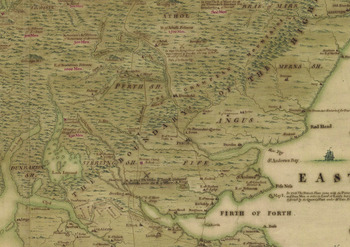
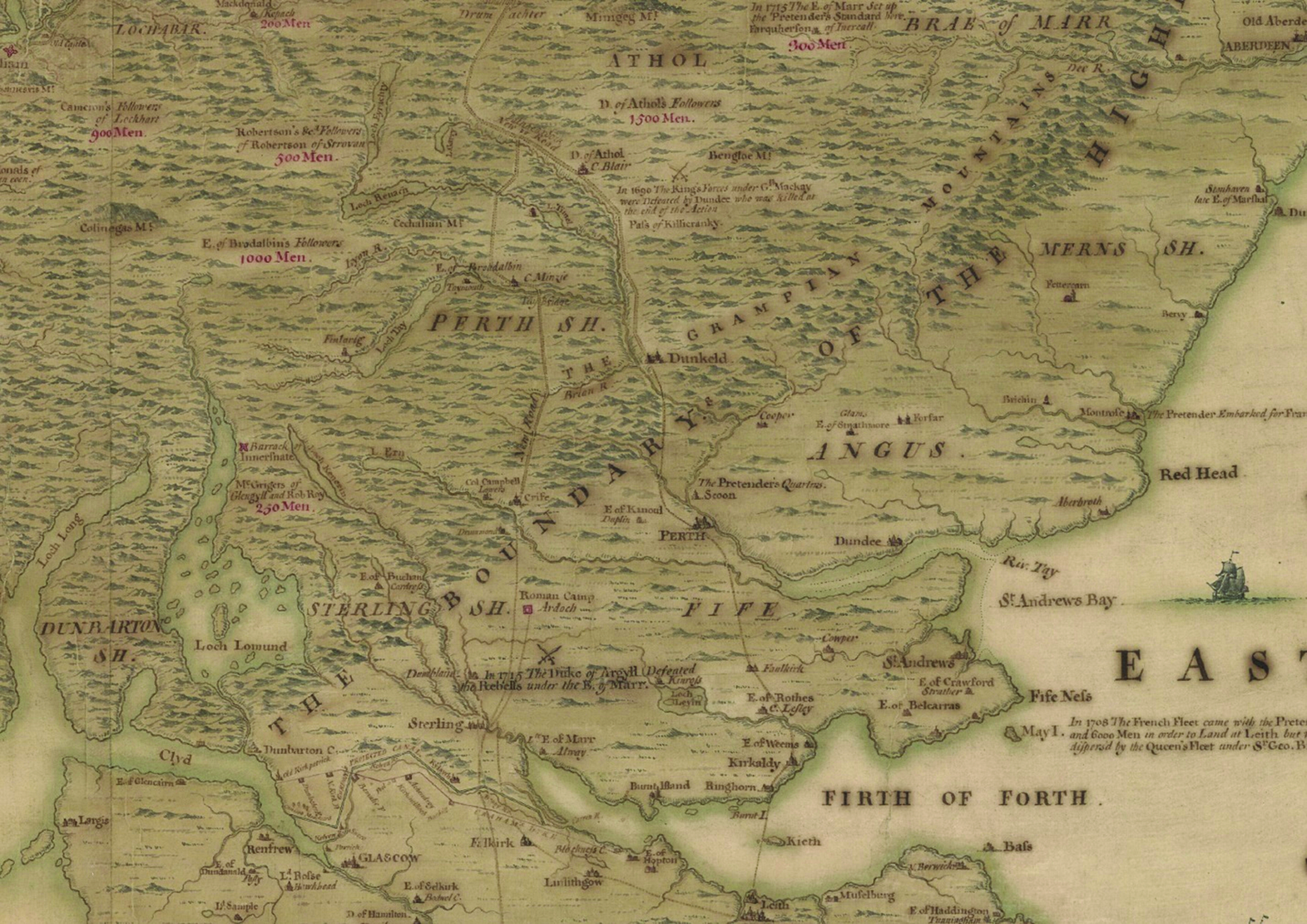
At the early moment of the Age of Exploration when Walter Scott met Mungo Park, Africa was present to the European imagination only as a formal absence. Less than a century earlier, however, Scotland’s interior remained a similar void on European maps. In the 1720s Daniel Defoe writes in his Tour through the Whole Island of Great Britain, “Our geographers seem to be almost as much at a loss in the description of this north part of Scotland, as the Romans were to conquer it; and they are oblig’d to fill it up with hills and mountains, as they do the inner parts of Africa, with lyons and elephants, for want of knowing what else to place there” (see Figure 1).Footnote 18 Though it goes unmentioned by Defoe, he had journeyed to Scotland on Crown business, as a kind of proto-spy charged with collecting information and promoting the Crown’s interests.Footnote 19 It was on the Crown’s behalf, then, that his Tour sought to consolidate the 1707 Union of Scotland with England and Wales in a new moral and social order. The Tour claimed to mark out the full circumference of the newly enlarged polity, reinscribing the whole island through the procedures of Old Saxon land tracts, which were, in Defoe’s time, annually ritualized in the celebrations of Ascension Day. As Pat Rogers explains, Defoe “was mimicking the ancient ties of ‘beating the bounds,’ when local officers, accompanied often by children, would make a complete circuit of the parish. Before accurate mapping or surveying existed, this was a way in which a community could establish its borders and proclaim its identity. This ritual, commonly performed on Ascension Day, had its religious and mystical functions, and when he projected the ceremony on a national scale Defoe carried out his own piece of sympathetic magic, as though placing feet into the water would absolve him from error, and thus confirm the claims he is making of behalf of Britain.”Footnote 20
Detail from Clement Lemprière’s A Description of the Highlands of Scotland (c. 1731). The indistinctness of the hills that fill the interior of Scotland, beyond the “Boundary of the Highlands” marked on the map, leads Fleet, Wilkes, and Withers to note “an uneven ignorance regarding the shape and content of the geography of the Highlands” in the period leading up to the 1747 rebellion. Cristopher Fleet, Margaret Wilkes, and Charles W. J. Withers, Scotland: Mapping the Nation (Edinburgh: Birlinn, 2011). Like Defoe, Lemprière, a Frenchman employed by the Board of Ordnance, describes Scotland’s geography through reference to Roman occupation, as he marks the site of the Roman encampment at Ardoch alongside battle sites of the 1715 conflict. Reproduced by permission of the Trustees of the National Library of Scotland.
The symbolic dimensions of Defoe’s project responded to the material threats that confronted the fledgling Union at the time of his visit. In the previous decade, a series of rebellions by Jacobites loyal to the superseded Stuart line rose in Scotland and threatened not only the Hanoverian succession, but the integrity of the newly created Kingdom of Great Britain. During the same period, the Crown built a series of forts throughout Scotland in an effort to prevent future risings. These measures proved insufficient, however, when in 1745 “Bonnie Prince Charlie,” the son of the Stuart claimant to the throne, landed in the Highlands and marched a force as far south as Derby. The reaction from the imperial center to this later insurrection was more severe than the first, and completely remade Scotland’s material and cultural forms: the forts built in the aftermath of earlier risings, which had failed to suppress the coming of Bonnie Prince Charlie, became centers in a network of roads that opened up the country to the full force of the British infantry; the countryside was disarmed of its means of defense, as guns were collected by occupying soldiers; and markers of cultural difference, like plaid and the Gaelic language, were targeted for extermination, as kilts were outlawed and English-language schools were opened in rural scenes.Footnote 21
This pattern of reaction makes a strong case for understanding the aftermath of Union as a form of “internal colonization,” a claim that remains controversial four decades after it was first made by Michael Hechter.Footnote 22 We will have reason to return to the controversy surrounding Scotland’s coloniality further on, but in advance of that discussion I would first like to further explore the relationship between material forms and their appearance in Scotland in the period. The figure of the Highlands that Scott would become famous for depicting, the same that would be deployed in colonial Kenya to prepare the way for White settlement, depended on the development of a logic of material and aesthetic control that look shape through the elaboration of Highland landscape, as what I have called, in this article’s introduction, a form of aisthesis, or a “regime of perception.” As it became widely acknowledged in London that Scotland’s terrain, and the government’s poor knowledge of it, presented a significant impediment to military control and cultural integration, the Crown initiated a massive cartographic project, the Military Survey of Scotland, designed to enumerate those regions, as Defoe says, that geographers had for so long been at a loss to describe, and to replace their indistinct hills and mountains of Lemprière’s map with an accurate picture of its space. As the project’s deputy, Major-General William Roy, would tell the Royal Society in 1785, the 1745 rebellion “convinced Government of what infinite importance it would be to the State, that a country, so very inaccessible by nature, should be thoroughly explored and laid open, by establishing military posts in its inmost recesses, and carrying roads of communication to its remotest parts.”Footnote 23
The resulting efforts both rendered Scotland’s Highlands easily accessible to British military excursion for the first time and mapped the country in its entirety. In the absence of more refined cartographic method, however, the Military Survey relied heavily on what we, nearly three centuries later, would see as artistic production. Roy himself says, “It is rather to be considered as a magnificent military sketch, than a very accurate map of a country.”Footnote 24 While the Military Survey’s map would be superseded over the course of the next century, however, it made a lasting contribution to the landscape aesthetics of the time.Footnote 25 The project sent its surveyors out into the country in the summer, where their work included producing topographically accurate sketches of the terrain that, after they had returned to Edinburgh at the season’s end, would be collated by a draftsman into the map’s massive Fair Copy. The career of the Survey’s chief draftsman, Paul Sandby, discloses the relationship between the survey and the new imperative to topographical accuracy in landscape that developed at the time. While we tend to remember eighteenth-century landscape more for Thomas Gainsborough and the controversies surrounding the picturesque, Sandby’s renown was sufficiently established by the 1760s that Gainsborough himself declined a commission to paint for Lord Hardwicke, to Sandby’s benefit: Gainsborough wrote to Lord Hardwicke that Sandby, and not himself, was “the only Man of Genius” equipped to paint “real Views from nature in this Country.”Footnote 26
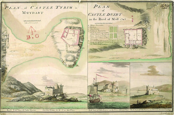
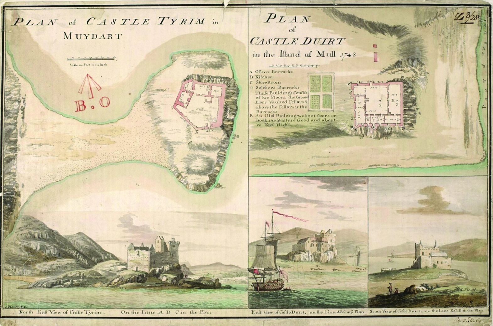
Later a founding member of the Royal Academy, Sandby was a young man when his elder brother secured him a place on the survey team, and it was his experience in Scotland that shaped his later aesthetic sensibility.Footnote 27 As his son wrote in his obituary, “Perhaps the destination of Mr. Sandby to the Highlands was the source of his eminence as a landscape painter, at least in the formation of his peculiar style, as, though he there saw nature in her wildest form, the necessity under which he lay of attending to particular accuracy in filling up the plans, may be supposed to have formed in him that correct and faithful habit, with which he after viewed and delineated her” (see Figure 2).Footnote 28 The accuracy with which Sandby produced landscapes depended upon not only the vision, but also the techniques he employed while working on the Survey. “Sandby adapted the map-making technique to his own topographical ends—the conventional colors of the ordnance maps, blue green for water and yellow for land under cultivation are repeated in Sandby’s landscape views. The military practice of showing the shape of a mountain by aligning the brush stroke with the direction of the slope was one that the artist also adopted.”Footnote 29 Through Sandby, then, an imperative to verisimilitude in representations of landscape entered aesthetic practice. Critical accounts of landscape aesthetics at the time largely focus on the controversies surrounding William Gilpin’s picturesque, which, while it inspired a generation of “picturesque tourists” to scour Britain for pleasant views, was widely seen as distorting the objects of its representation. In 1807, for example, James Clark, a Scottish land surveyor and author of his own tour guides, wrote that “Whoever examines those ‘abortive nothings,’ which Mr. Gilpin calls Landscapes, will hardly be able to trace one view, how well soever he may be acquainted with it: for my own part, they put me in mind of nothing so much as those landscapes and figures which boys fancy they see in the sky at sun-set, or in fire on a frosty evening.”Footnote 30 If Sandby’s topographical landscapes were denigrated by Gainsborough and other more “refined” eyes, by the early nineteenth century, his accurate style had become de rigeur in the genre—even if, ironically for Sandby, that accuracy was thought only a necessary foundation for the atmospheric productions brought into vogue by Turner.Footnote 31
Paul Sandby, Plan of Castle Tyrim in Muydart/Plan of Castle Duart in the Island of Mull (1748). Reproduced by permission of the Trustees of the National Library of Scotland.
Through Sandby’s activity in the Military Survey of Scotland, then, eighteenth-century landscapes embed a measure of material and cultural control over space that foreshadows what Bernard Cohn has identified as the “survey modality” of colonial epistemology. The parallels between that Survey and imperial enterprise overseas become clear where Cohn writes, “The word ‘survey’ in English evokes a wide range of activities: to look over or examine something; to measure land for the purpose of establishing boundaries; to inspect; and to supervise or keep a watch over persons or place … For the British in India in the late eighteenth century, it also meant a form of exploration of the natural and social landscape.”Footnote 32 More than even a continuity in spatial logic, the connection between the Military Survey and similar cartographic projects overseas has a direct, material connection that should be mentioned here as well. As Major-General Roy himself noted, while the Military Survey “perfectly answered the purpose for which it was originally intended,” it would only be superseded through scientific and mathematical improvement (specifically, the development of geodesy and the production of a series of new instruments of measurement), directly connected to imperial activity in India. The survey device, a massive tool called a theodolite, which eventually completed the Ordnance Survey of Britain, was originally ordered from its inventor by the British East India Company, but fell to domestic use instead. Stocked with adequate tools only a few years later, the Company began its massive Great Trigonometrical Survey in 1801, completing its work over the next seventy-odd years, finally finishing only eighteen years after the Ordnance Survey reached its own conclusion.Footnote 33
Affect and Colonial Historiography
Given the connections between imperial activity overseas and the Crown’s reaction to Scotland’s series of rebellions following Union, in what sense was Scotland not colonized by the English? Michael Hechter, the first to argue that the relationship between England and the “Celtic Fringe” of the British isles constitutes a form of “internal colonialism,” concedes in the introduction to the second edition of his study that colonialism in Scotland proceeded unevenly, so that while the case for colonialism in the Highlands is clear enough, the Lowlands enjoyed a great deal of development and what Hechter calls “institutional autonomy.”Footnote 34 It is the dissonance between these two intra-Scottish regional histories that, in part, muddies the water as to the question of calling Scotland as a whole a colonial possession. Hechter notes that “One irate Scottish reader fired off a three-page letter to my publisher enumerating a long list of Scottish firsts, from logarithms to bleaching powder, and concluded with the suggestion that: ‘you respectfully advise Michael Hechter that Scotland had reached the peak of its Industrial Revolution before the U.S.A. had even started. The U.S.A. did not start properly until after the Civil War and consequently had a flying start as a result of the creative efforts of the Scots whom he has so studiously attempted to denigrate.’”Footnote 35
Although Hechter offers this criticism as he corrects his argument regarding Scotland’s colonial past, specifying how the case for colonialism in Scotland is much stronger in the Highland context, the terms of his readers’ objection give us notice of the affective stakes of Hechter’s argument, which are worth considering further here, before we conclude this section to examine how the forms of Highland landscape were deployed in Kenya in the next section. Hechter’s new introduction to his work catalogues several critical responses to his argument, not only in relation to Scotland but to Wales and Ireland as well. Each of these, however, derives its energy from a rejection of charges of racism against the English. A review of the study in Parliamentary Affairs, for example, notes that “We have all got used to being called colonialists but in this book the English are repeatedly accused of racism, both personal and institutionalized, towards the Scots, Welsh, and Irish.”Footnote 36 For this reader, stories of individual success for natives of Britain’s fringe nations give the lie to this charge. I do not think it necessary here to explain why the success of an elite few in no way precludes the presence of systemic racisms. What I do want to mark here, however, is the affective sensitivity Hechter’s argument generates because it is allied to the same sensitivity that emerges in response to the Scottish nationalism that develops from the 1970s onward, which will in turn bear on the question of the Scottish role in empire.
The Oxford historian Hugh Trevor-Roper, for example, is incensed by claims that the Crown suppressed Scottish cultural forms in its eighteenth-century reaction to Jacobitical rebellion. The kilt, Trevor-Roper argues, could not be suppressed through Crown response because it was itself an eighteenth-century invention. (In this sense he goes well beyond the 1746 Disarming Act, seeking not only to repress the kilt’s association with Highland culture, but to prove its historical non-existence.) His essay in Eric Hobsbawm and Terence Ranger’s The Invention of Tradition is a virulent polemic against the inauthenticity of the kilt’s history.Footnote 37 As Trevor-Roper has noted, the kilt only appeared in the eighteenth century, between Jacobitical rebellions, as a syncretic adaptation of the “belted plaid” to the exigencies of industrial wage labor, its later rise into the fashion of the late century’s romantic “Celtic revival” made possible by a fraudulent historiography—itself supplied by master literary forger James MacPherson and supported by Scott’s romantic historical fictions. For modern readers, however, it is difficult to sympathize with Trevor-Roper’s sense of scandal. Forty-odd years after Foucault’s History of Sexuality argued that Victorian repressions proliferated rather than quashed deviant forms of sexuality, Trevor-Roper’s shock at the “sheer effrontery” of a modern invention of a fictional past seems quaint.Footnote 38 The essay retains a power to shock, however, in its bizarrely chauvinistic denigration of Scottish cultural history, his insistence that a fifth-century migration from Ulster made all Highlanders “essentially an Irish overflow” even twelve centuries later, and his denigration of all Scottish literature as a “crude echo” of purloined Irish forms.Footnote 39 (Trevor-Roper does not, when it comes time, cast similar aspersion against English appropriation of French literary forms or begrudge the English their Saxon ancestry.) This controversy over authenticity nonetheless makes clear for us, through the vibrant terms of its intensity, the survival of an imperative to verisimilitude in an affective register in the representation of Scottish appearances. Perhaps most damagingly to Trevor-Roper’s indignation, however, is a passage in Scott’s “Culloden Papers,” wherein that propagator of fraudulent Highland authenticity acknowledges the very same history of the kilt’s modern invention on which Trevor-Roper’s accusation turns, in what we easily read as a repudiation of Trevor-Roper’s polemic: the Englishman Rawlinson was indeed the inventor of the Filea-beg, Scott writes
But this was only a slight and obvious improvement on the ancient belted plaid. That dress was formed in a very primitive manner, by wrapping one end of a web of tartan round the loins, so as to form a petticoat, and disposing of the rest around one shoulder, to be drawn over both in case of a storm. This dress, though well-fitted for the hunter or herdsman, was inconvenient to labourers. Mr. Rawlinson observed that, in the belted plaid, the most necessary part of a man’s dress was indivisibly united to that which is most occasional, as if a lowlander’s great coat was sewed to his breeches. He recommended to the highlanders whom he employed, to wear a short petticoat, secured with a buckle, and separated from the plaid, which could be then laid aside at pleasure. This innovation is called the filea-beg, or kilt; and it is an improvement which by no means affects President Forbes’s remarks on the antiquity of the highland dress.Footnote 40
Claims of Scottish coloniality and the historiography of Scottish nationalism are both met with a vehement affective denial. What I want to suggest here is that each affective reaction is enabled by the survival of an imperialist identity into the postcolonial period. Postcolonial scholars who recognize the cultural-historical patterns of colonization in the Crown’s eighteenth-century Highland adventure will, I think, also remember Trevor-Roper as a villain of Chinua Achebe’s famous paper on Joseph Conrad’s image of Africa, for he appears there as “that erudite British historian and Regius Professor at Oxford” who pronounced “a few years ago that African history did not exist.”Footnote 41 And the terms marshaled by Hechter’s nationalist interlocutor—Scottish firsts, logarithms, bleaching powder—echo debates in nineteenth-century racial science, where such civilizational accomplishments were understood as evidence of racial difference. The imperialist affect of each position—the vituperation of both the English Trevor-Roper and Hechter’s anonymous Scot—should make clear that my intention in this article is not simply to apologize for Scottish service in empire, either whole cloth or in part, by weighing it against a somehow greater injustice perpetuated by the English. What I am instead calling attention to is that the disregard for the colonial history internal to the British Isles allies us—albeit unintentionally—to an entrenched imperialist perspective that our field defines itself against, ethically and epistemologically. From the perspective of Britain’s overseas colonialism, the rejection of Scotland’s colonial past modulates into the effacement of the Scottish role in colonial enterprise.Footnote 42 In the following section, however, we will leave questions of meta-historiographical affect behind to examine how the figure of the Highlands in Kenya shaped settler culture in the White Highlands it prepared for European habitation.
Highland Landscape in Colonial Kenya
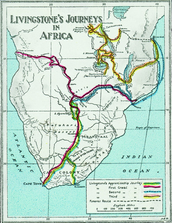
In the final two decades of the nineteenth century, much of East Africa remained as intractable a problem for geographers as it had been in Defoe’s time. Although cartographic conventions had moved beyond filling it with “lyons and elephants,” Livingstone’s famous expedition had skirted the territory that would become Britain’s East Africa Protectorate (see Figure 3), so that on the maps of the 1884 Berlin Conference, the region remained hinterland, valuable to the Crown’s diplomats not for its resources, or its potential for exploitation, so much as for strategic considerations. In order to safeguard the Crown’s interests in India, it seemed vital to protect the Suez and its passage to the Arabian Sea; holding the Suez, in turn, required controlling Egypt and the headwaters of the White Nile near Buganda.Footnote 43 Once appropriated to the Crown, the largely unmapped and unconsidered territories demanded elaboration within the landscape of empire, just as Scotland had more than a century earlier. Coming at the end of the Victorian century, when cartographical and other scientific expeditions surveyed East Africa’s hitherto unknown spaces to take control of the region by “defining and classifying space,” in Cohn’s phrase, they had a wide library of scientific and aesthetic precedent, of similar efforts not only in Scotland but in India, Australia, and South Africa.Footnote 44 As I will argue here, however, the forms of landscape that coalesced in Scotland remained predominant in the scientific and aesthetic elaboration of East Africa—so much so that Kenya emerged in empire’s vision within the framework of Highland landscape.Footnote 45
“Livingstone’s Journeys in Africa,” published by the London Missionary Society around 1900. The equator, marked by the top margin of the map, runs through Kenya’s central highlands. © National Portrait Gallery, London.
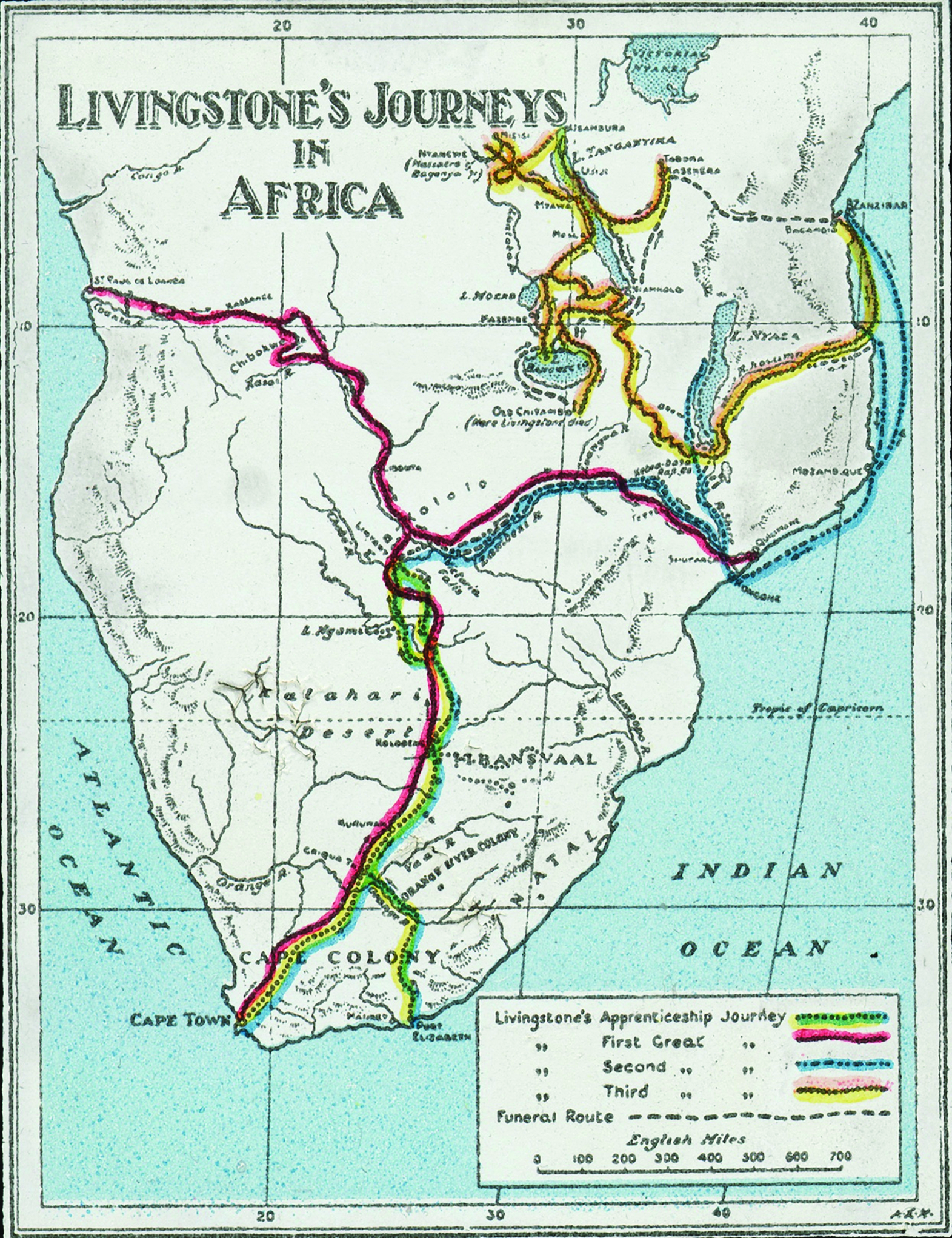
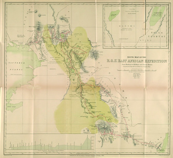
This article began with Mungo Park and a note that Scots played an outsized role in the exploration of empire, and Kenya is no different. Though Livingstone stayed to the south—his final expedition trekked into Central Africa through present-day Tanzania—the first major British expedition of the territory acquired by the Crown at the Berlin Conference was nonetheless headed by a Scot (see Figure 4). Joseph Thomson was born in the village of Penpont in Dumfriesshire and, as his brother makes clear in his posthumous biography, was shaped from an early age by the landscape of that country. “The entire district,” his brother writes, “is a veritable land of delights to one gifted with the seeing eye and the responsive fancy; and, from what has already been said, it was but to be expected that the embryo explorer’s interest and curiosity should be speedily aroused. The romance of his environment gradually took possession of him, and more and more ruled the thoughts of his boyhood and youth.”Footnote 46
“Route Map of the R. G. S.’s East African Expedition from Mombasa to Mt. Kenia and Victoria Nyanza,” in Proceedings of the Royal Geographical Society and Monthly Record of Geography 6.12 (December 1884), after 758. Image from the Digital Collection of the University of Illinois Library.
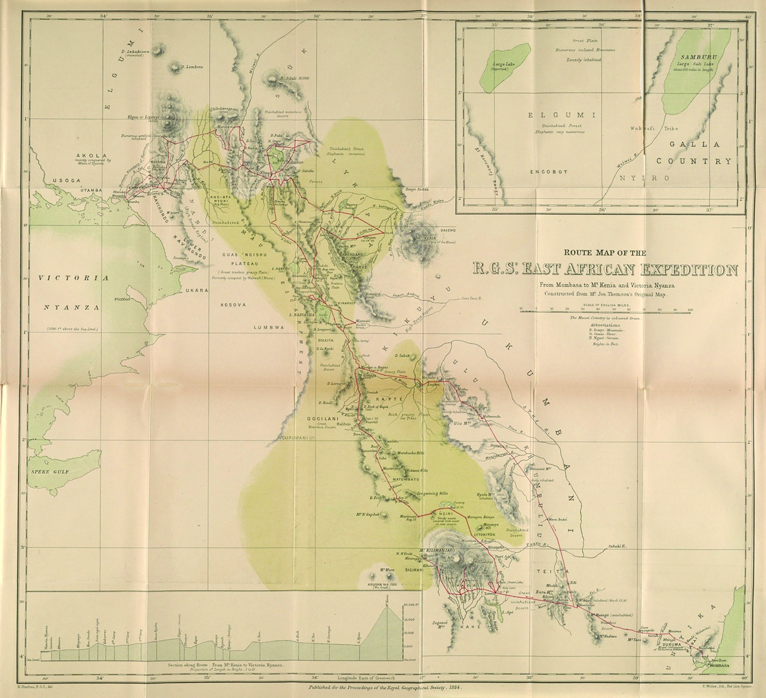
As was the case with Park, for Thomson the Scottish landscape of his natal place doubled African scenes of exploration, though for Thomson that doubling is enabling not by his own experience, but by the accounts of the Scottish explorers who roamed Africa before him.Footnote 47 His desire to travel to Africa germinates in the landscape of his youth, when he discovered the stories of Park, Bruce, Moffat, and Livingstone:
It was when he was about eleven years of age that the bent of mind which was practically to determine the drift of his life became discernible to himself. His eldest brother … happened to bring to him, as a present, a volume descriptive of travel in strange lands. He was fascinated and wanted more. The lives of the explorers were eagerly sought out by him. With the narratives of Mungo Park, Bruce, Moffat, and others, he was soon perfectly familiar. Then the works of Livingstone fell into his hands. He greedily devoured them, and they seem to have awakened new thoughts within him. In those simple, unconventional records of the patient, large-hearted missionary-pioneer, he realized something more than the glamour belonging to adventures and hair-breadth escapes. The mystery and pathos of Africa’s darkness here came near to him and laid hold of his imagination. He was touched with a feeling of Livingstone’s compassion for the benighted tribes, and his mind wandered, in a tender questioning way, over those large spaces on the map of that long-neglected continent marked “unknown.”Footnote 48
If the resolve Thomson developed in view of border hills fomented in boyhood fantasy, an aesthetic sensibility recurs frequently in his account of his adult expeditions. In narrating his first sight of Mount Kenya, for example, Thomson’s prose flies into romantic rapture as he writes, “As pious Moslems watch with strained eyes the appearance of the new moon or the setting of the sun to begin their orisons, so we now waited for the uplifting of the fleecy veil, to render due homage to the heaven-piercing Kenia.”Footnote 49 What I want to emphasize here, however, is how Thomson returns to the library of Scottish landscape during his account.
After a couple hours’ careful march along the interlacing roads we reached a place supposed to be near the Wa-kikuyu. In response to a thundering volley from our guns, hundreds of natives sprang suddenly to view,—
And every tuft of broom gave life
To dusky warrior armed for strife.
They had evidently been swarming in the woods all the time, watching our movements and looking out for an opportunity to attack us.Footnote 50
The moment narrated here is the sudden emergence of Gikuyu from the enveloping forest, who are summoned by the expedition’s gunshots and “swarm” threateningly, had been “watching our movements and looking out for an opportunity to attack us.” At the center of the account, however, is a literary invocation. Offset from the narration is a couplet from Scott’s Lady of the Lake, adapted to the object of Thomson’s description; the original reads
And every tuft of broom gave life
To plaided warrior armed for strife.Footnote 51
Thomson here cites and alters Scott’s romantic poem, replacing “plaided” in the original for “dusky.” This alteration excises the metonym for Scottishness in the original in an overdetermined substitution that indicates both the darkness of Gikuyu complexion and the dim light of the forest. The effect of this double meaning is to arrogate the Gikuyu to the forest, and the forest to the Gikuyu; it produces an identity between native and landscape, multiplies the propinquity of Highlander to Highland in Scott’s original. It also treats the Gikuyu as a function of landscape: their appearance animates the scene, but they aren’t the agent here, are only given life. They are born from the landscape, are the forest made flesh.
For Thomson, then, the exploration of Kenya is not only a material but also an aesthetic exercise, one that draws on Scottish landscape as it shapes alien space. Thomson’s aesthetic does more than stylize his narrative, but shapes the production of scientific knowledge.
We were not considerably over 6000 feet in elevation, and I was thrown into ecstasies of delighted surprise in observing several very fine coniferous trees (junipers and podocarpus), rising to a height of little short of 100 feet, among magnificent Cape calodendrons, splendid-flowering trees never before supposed to be found north of Natal. The whole scene was singularly rich and varied with the numerous trees of temperate aspect, and the dense undergrowth of bushes, mostly covered with charming flowers which emitted a rich, though heavy, perfume. Beautiful glades honeycombed the forest, and cattle-paths connected them with each other.Footnote 52
Aesthetic experience here meets botanical and geographical description. Thomson is concerned to show the arrangement of Highland trees, their “temperate aspect” and contribution to the charming effect of the scene. Here, as well as across the body of early exploratory accounts, flora generally serve a double role in aesthetic and scientific discourses: the “trees of temperate aspect” and “charming flowers” mark out an aesthetic frame within which Thomson specifies discoveries related to species distribution. The appearance of botanical description within colonialist landscape in Kenya marks a deep interrelation, not only between landscape and botany, but between landscape and colonial science. Landscape and scientific elaboration are, in effect, deeply interrelated, mutually articulating discourses: landscape frames and facilitates scientific observation, while at the same time that observation provides the occasion for aesthetic production.
The embeddedness of Scottish landscape within exploratory accounts of Kenya paves the way for its reconstruction as a Highland space, which would become a vital precondition for White settlement. By naming the area north-northwest of Nairobi the White Highlands, colonial settlers imported a dense network of associations that prepared the space for settler colonial expropriation. In 1901, the English explorer Sir Harry Johnston wrote of the region that “here we have a territory … admirably suited for a white man’s country.”Footnote 53 Johnston’s remarks are predicated on his subsequent—and heavily contested—observation that “I can say this, with no thought of injustice to any native race, for the country in question is either utterly uninhabited for miles and miles or at most its inhabitants are wandering hunters who have no settled home, or whose fixed habitation is that lands outside the healthy area.”Footnote 54 In the “geography of racial physiology” at the time, “healthy area” is an operative distinction; as Alison Bashford notes, the question of the “sciences of the relations between climate and constitutions, capacity, and difference” of the time was “Could white people work and reproduce normally and effectively in the tropics?”Footnote 55 By referring to a portion of the East African Protectorate as “healthy” for Europeans, Johnston was making a somewhat radical claim, that an area within a degree of the equator could well-support White settlement. He was, in effect, carving out a space fit for European habitation from the otherwise unsound territory of Africa’s interior.
The renaming of Kikuyu as Highlands were crucial in this representational, political, and epistemological effort. From the outset, landscape played a large role in the settler project. As Sir Charles Eliot, commissioner of the protectorate from 1902 to 1904, called the region a “tabula rasa, an almost untouched and sparsely inhabited country, where we can do as we will, regulate immigration, and open or close the door as seems best,” he reiterated Johnston’s claims through a figure whose graphic associations invite aesthetic reconfiguration: describing the landscape as tabula rasa paves over African presence in the space and facilitates its reshaping within colonial fantasy.Footnote 56 The aesthetic production of Kenya was, indeed, central to the development of settler ambition—the territory’s aesthetic character, its similarity to “English country scenes” and “Scotch moors” opened the door to European habitation.Footnote 57 Eliot even writes that he would “fain see” the capes and headlands surrounding Lake Elmenteita “crowned with a few castles or temples, though I fear the real old African would think such erections a desecration of his favourite wilds.”Footnote 58 For Eliot and the settler interest he represented, the aesthetic character of the country invited its reconfiguration within domestic forms, ready for the plow and adornment with tropes of British landscape.
Although the application of British landscape to Kenya domesticates the African wild within comfortable aesthetic frameworks, it does little to answer the climatological fears of the period. If “English country scenes” produced an isomorphism between Kenya and southern Britain, the association between “Scotch moors” and the figure of the Highlands quarantines the space from contaminating contact with Africa’s interior. Over the course of the nineteenth century, the Highlands had become a space packed with romantic associations. While in 1776 Samuel Johnson had written that the appearance of the Highlands in Scotland is “that of matter incapable of form or usefulness, dismissed by nature from her care and disinherited of her favours, left in its original elemental state, or quickened only with one sullen power of useless vegetation,” in the works of Walter Scott, Scotland’s north became a “land of military and romantic adventures” that conjures scenes previously only imaginable as “occurring in ancient times.”Footnote 59 Although the figuration of East African space as White Highlands certainly appropriates these romantic associations, it also imports another character of Highland mythology buried in Scotland’s colonial past. What Roy names the inaccessible nature of the Highlands became, in the social scientific literature emerging during the late-eighteenth century, a boundary that produced cultural difference. Johnson demonstrates this point as he explains:
Mountainous countries commonly contain the original, at least the oldest race of inhabitants, for they are not easily conquered, because they must be entered by narrow ways, exposed to every power of mischief from those that occupy the heights; and every new ridge is a new fortress, where the defendants have again the same advantage.Footnote 60
In Adam Smith’s The Wealth of Nations, the boundary of the Highlands similarly enables the survival of social organizations that had long since been superseded elsewhere in Europe:
Without remounting to the remote antiquities of either the French or English monarchies, we may find in much later times many proofs that such effects must always flow from such causes. It is not thirty years ago since Mr. Cameron of Lochiel, a gentleman of Lochabar in Scotland…Footnote 61
Within the context of this history, the “Highlands” in Africa become not only the grounds of romantic attachment, but a figure of absolute difference capable of insulating a region of White settlement from the cultural and climatological malaise of Africa. The separation from the rest of Britain that the Highlands mark in Scotland is radicalized in Africa as an ontology that transfigures its space into a “White” home. The discovery of “Scotch moors” in the Highlands is, in effect, a necessary precondition for finding “English country scenes” in the Highlands’ interior. Thus, Isak Dinesen writes that on her farm in the White Highlands, sitting atop “Africa distilled up through six thousand feet,” “The chief feature of the landscape, and of your life in it, was the air. Looking back on a sojourn in the African highlands, you are struck by your feeling of having lived for a time up in the air.”Footnote 62 To be sure, Dinesen’s Out of Africa is marked by the same anxious repetition of difference that usually characterizes colonialist discourse. At moments the European capacity for landscape and the geometrical shapes forged through agriculture confirm her right to ownership and facilitate her affective connection to her farm; at others, the boots that she and her European compatriots wear insulate them from the mass of Africa’s matter, “a heterogenous upheaping of congenial atoms” that subsumes flora and fauna, rock and African within its chimerical formulation.Footnote 63 Throughout her novel and the whole of colonialist Kenyan literature, however, the figure of the Highlands foregrounds the possibility of European attachment to East Africa and makes their presence and cultural production possible.
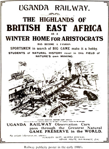
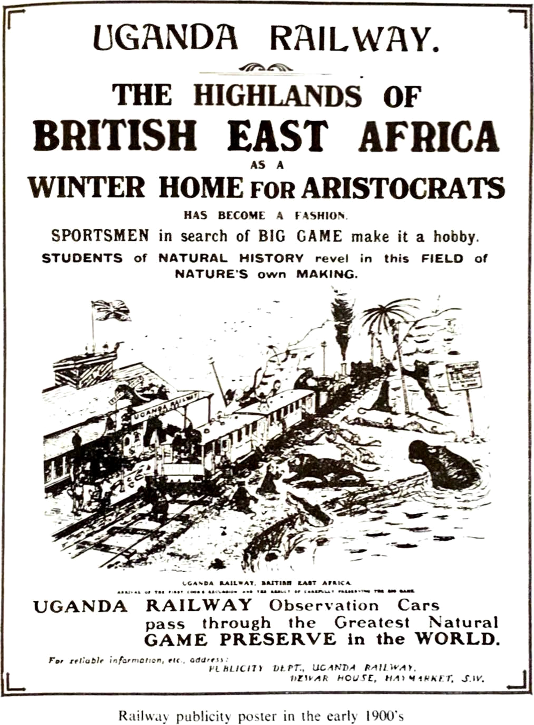
As the predominant logic shaping what Rancière calls the “division of the sensual,” Highland forms were both a vital precondition of White settlement in the area and the defining force in the region’s colonial culture, evident not only in literature but in British advertisements of the region (see Figure 5). The romantic landscape of the Scottish Highlands had, during the eighteenth century, become a playground for the aristocracy, offering space for aristocratic pursuits like game hunting and agricultural improvement.Footnote 64 As industrial development and population growth gradually foreclosed that possibility in Scotland, keen advertisers offered up the White Highlands as an African alternative. Abdul JanMohamed’s reading of Dinesen is instructive here:
Uganda Railway advertisement. Reprinted in M. P. K. Sorrenson, Origins of European Settlement in Kenya (Nairobi: Oxford University Press, 1968), 181.
Kenya confers upon its privileged immigrants a sense of vitality and grandeur which they could not find in Europe. Within this liberating and intoxicating atmosphere, the immigrants act out their antique fantasies by behaving like knights errant … It is the very atavism manifested by Dinesen and the two aristocrats [Berkeley Cole and Denys Finch-Hatton, the author’s friends who are represented in the novel] that apparently allows them to be comfortable in Africa and that, in their view, permits the natives to develop an “instinctive attachment” for them.Footnote 65
Dinesen’s Kenyan landscape therefore becomes the scene for the performance of an atavistic character, the aristocratic identity of the knight errant, cultivated in Scott’s fiction but which had been displaced from Britain itself through the development of its history.
***
The consolidation of colonial rule over Kenya, the preparation of its “White Highlands” for colonial settlement, depended upon the elaboration of its space within the aesthetic forms of Scottish landscape. As I have argued, however, the production of those forms was itself dependent upon a colonial history internal to the British state that remains obscure within extant treatments of empire. The renewed attention to form in recent literary studies has been heavily critiqued—rightly, I think—for an evacuation of historical content from aesthetic study, but as I have shown, the history of landscape in empire is important insofar as it points to aspects of empire’s material history that remain obscure in predominant accounts. Far from removing us from the material activity of empire, then, the intimacy of landscape in Scotland and Kenya signals important lines of inquiry for future postcolonial critique. Indeed, the connections between aesthetic discourse, scientific study, and social forms discussed in this article suggest we think of landscape as more than a representational form, but as a logic that profoundly shaped colonial history—as more than an aesthetic, but a form of aisthesis that determined the course of empire and defined the exercise of its power.