Introduction
As one of the many archaeologists whose careers and personal lives have been transformed by working on Libya's extraordinary archaeological heritage, it is a pleasure to offer these brief reflections on the remarkable role played by the Society for Libyan Studies in supporting scholarship on Libya's history over the past 50 years. This is an occasion for backward reflection, so I have focussed on the projects in which I have been involved. Like other contributions, they illustrate the Society's impressive history of mobilising limited resources to address significant questions about Libya's past, often with important resonances for Libya's present and future well-being. The linking theme I have focussed on is the study of the ‘cultural landscapes’ informed by Libya's archaeological heritage: the landscapes that have shaped peoples’ lives, and in turn been shaped by them.
Urban consumption and rural production: zooarchaeology at Sidi Khrebish
A major driver in the Society's formation was the destruction wrought by unplanned development associated with the burgeoning oil economy in the late 1960s. This had a direct effect on the deserts where the oilfields were located and on the pipeline routes, but the impacts of rapid development and construction brought by the new wealth were particularly apparent along the coastal littoral where most of the population lived in the major urban conurbations and in the agricultural hinterlands that supplied them. John Ward-Perkins, Director of the British School at the time, had acted as Chief Archaeologist for Libya in the months following the retreat of the Axis forces from Libya to Tunisia after the battle of El Alamein in World War II. He was instrumental in the formation of the Society in the late 1960s, a particular priority for him being to help the hard-pressed Libyan Department of Antiquities carry out rescue excavations in the Graeco-Roman cities most threatened by urban development.
The flagship archaeological project for the Society at its inception was the excavations of Sidi Khrebish, a suburb of Benghazi, Libya's second city and capital of the eastern province of Cyrenaica (Figure 1). Urban development here was threatening one of the most important zones of Berenice, the Greek and Roman city underlying modern Benghazi. The excavations were brilliantly directed by John Lloyd, and contrasted in their rationale and approach with many previous excavations at major Graeco-Roman cities such as Lepcis Magna, Sabratha and Cyrene that were little more than clearance operations to expose and restore monumental civic structures. The Sidi Khrebish project was an excellent example of modern urban excavation (Lloyd Reference Lloyd1977, Reference Lloyd1979, Reference Lloyd1982, Reference Lloyd1985), like the parallel rescue excavations directed by Henry Hurst at Carthage in Tunisia (Hurst Reference Hurst1975), which used the excavation and recording techniques that had been pioneered on deeply stratified British urban sites such as London. These involved detailed stratigraphic excavation and the recording of individual stratigraphic units or ‘contexts’, supported by a wide range of specialist studies of the associated artefacts and organic remains. The Sidi Khrebish project established a robust chronological framework spanning the history of Benghazi from Hellenistic to Islamic times, and demonstrated the power of archaeology to reveal not just the great monuments of the past and their associated elites but also the lives of ordinary city-dwellers, the ‘people without history’. The excavations were completed in August 1975, and the following month was devoted to studies of the material by a range of specialists including Philip Kenrick (the fine pottery), John Riley (the coarse pottery), Don Bailey (lamps), Dimitri Michaelides (mosaics and wall plaster), Richard Reece (coins) – and myself to study the animal bones, a class of material that for many years had been discarded on many classical archaeology excavations around the Mediterranean, including in Libya.
Libya, showing sites and regions mentioned in the paper.

I had started my own field project the previous year, a multi-period survey and excavation project in the Biferno Valley in Molise in peninsular Italy (Barker Reference Barker1996), but as an undergraduate at the University of Cambridge I had studied zooarchaeology, the analysis of animal bones from archaeological excavations, with Eric Higgs, who had come late to archaeology after a career as a Shropshire sheep farmer. Zooarchaeology had been a major component of my PhD at the British School at Rome on the prehistory of central Italy, specifically the transition from hunting and gathering to farming economies, supervised by Higgs and mentored by Ward-Perkins. I began my undergraduate career studying Classics, and had paid a lot of attention to current work on Roman farming during my PhD, so when John Lloyd contacted me to invite me to study the Sidi Khrebish animal bones, I was intrigued and excited by the opportunity.
The animal bones in the excavations were primarily the result of the discard of food refuse, so represented a record of the food consumption activities of the Sidi Khrebish citizens, but they also provided a window on the rural production systems that had supplied the urban markets. I undertook flotation of sediment samples from the excavations to collect carbonized botanical remains, studied by Derrick Webley, to provide parallel information on the crops processed and consumed at the site.
In analysing and interpreting the bone and seed assemblages (Barker Reference Barker and Lloyd1982) I was influenced by studies of traditional life in the Gebel Akhdar before the impact of the oil economy, in particular by the historical geographer Douglas Johnson (Johnson Reference Johnson1973) and the anthropologist Roy Behnke (Behnke Reference Behnke1980). The Gebel Akhdar is the prominent massif that extends for some 300 km eastwards from Benghazi and c.100 km from the coast to the Sahara. At its western end the Gebel Akhdar is separated from the sea by a coastal plain, but in the central and eastern sectors the northern edge of the massif rises straight from the sea shore in a series of steep escarpments. Rising to almost 1000 m above sea level it receives over 200 mm of rain a year, the limit for dry farming without irrigation, that supports a semi-arid Mediterranean landscape like that of Crete or the mainland of southern Greece and gives the Gebel Akhdar its name, which translates as ‘Green Mountain’. With arid desert along the Gulf of Sirte on the western side, and on the eastern side to the Nile valley, and with the Sahara to the south, it is indeed a veritable island of green.
In his analysis of land use systems in the Gebel Akhdar in recent centuries, Johnson concluded that there were three main modes of subsistence. The coastal plain was used mainly by mobile goat herders with a very poor level of subsistence. The main rural population lived on the Gebel Akhdar combining floodwater farming with sheep, goat and sometimes camel pastoralism. They planted crops in wadi bottoms in the northern Gebel in the autumn and then moved south planting other crops as they moved their animals to the edge of the Sahara for the winter, returning north in the spring and harvesting the crops on the way. The third group were nomadic camel herders who spent the summer in the southern Gebel and ranged widely into the Sahara in winter. Behnke (Reference Behnke1980) provides a rich account of the lifeways of one community of transhumant agro-pastoralists that he lived with in the early 1970s, who moved between Soussa (Apollonia, the ancient port of Cyrene) on the coast and Mekhili on the edge of the desert. We cannot impose recent land use patterns simplistically on the past, but earlier societies (in climates similar to today's, that is) clearly had to adapt to similar seasonal patterns of temperature, rainfall, and vegetation growth. The ancient Greek authors Herodotus and Theophrastus tell us that the indigenous peoples of Cyrenaica were nomads who drove their flocks inland for the winter, and Herodotus says that they produced three harvests, first on the coast, then in the hills behind, and then in the deeper hinterland, very much like the agro-pastoralists described by Johnson and Behnke. In addition to the comments by the early Greek writers, and the recent ethnographies, there is a rich documentary record about the relations between rural and urban populations in Cyrenaica through the Graeco-Roman centuries, in particular the letters of Bishop Synesius of Ptolmeis writing in the fifth century AD (Bregman Reference Bregman1983).
Interpreting the Sidi Khrebish faunal and botanical assemblages in the light of these studies, I suggested that the system of settlement and land use before the establishment of the Greek colony of Berenice was probably much like those described by the classical authors and recent ethnographies (Barker Reference Barker and Allan1981; Reference Barker and Lloyd1982). There is little sign of conflict between the urban settlements and the rural populations in the Hellenistic period, suggesting that the establishment of the Greek cities and their rural hinterlands did not have a serious impact on the indigenous population. In the second and third centuries AD, however, there was a major expansion of settled agriculturalists across the best arable land of the northern Gebel, that, much like the farmers settled on the same land in the 1920s and 1930s by the Italian colonial authorities, put great pressure on indigenous lifeways and was a recipe for conflict. There is widespread evidence for the construction of fortified farms, with forts in areas of densest settlement and on the southern Gebel controlling the major wells and routeways into the Gebel. The third century AD appears to have been characterised by a catastrophic breakdown in the relationship between farmer and nomad. The process of agricultural appropriation continued, and this appears to have been the context for the emergence of camel-based pastoralism in the south, the third group in Johnson's scheme. The model is undoubtedly simplistic, as recent studies of Roman-period farms in Cyrenaica have shown (Buzaian Reference Buzaian2019), but the Sidi Khrebish project as a whole remains an outstanding example of how a modern archaeological excavation of an ancient city could reveal not just the ‘local lives’ of its inhabitants but also how they articulated on the one hand with their rural hinterland (my particular role) and on the other hand with the wider Mediterranean world.
As a student at Cambridge I had briefly toyed with the idea of specialising in early prehistory and had attended a few lectures by the Palaeolithic archaeologist Dr Charles McBurney. He ranged widely across Europe, Southwest Asia and North Africa, but one site dominated his lectures: the Haua Fteah, a great cave overlooking the Mediterranean sea some 250 km east of Benghazi below the Graeco-Roman city of Cyrene and a few kilometres east of its port Apollonia, where he had excavated in the 1950s and published the major results in the year I started studying archaeology (McBurney Reference McBurney1967; Figure 3). He had excavated a 14 m-deep trench in the floor of the cave and discovered what appeared to be the longest occupation sequence in North Africa, one that has ever since been pivotal to regional debates about the nature of human settlement through the last glacial cycle (the last interglacial, ensuing glacial, and the succeeding Holocene, the modern climatic era, a period spanning the last 130,000 years). I completed my recording of the Sidi Khrebish animal bones in time to leave two days free before my departure, and with John Lloyd's help travelled to Cyrene to spend the rest of the day amidst its ruins and, the next morning, to be taken by one of the Department of Antiquities staff to see the Haua Fteah. It fully lived up to my lecture notes! I was enormously affected by the grandeur of the site and all that it symbolised in terms of the deep past. Returning the next day to Italy to my Biferno Valley Survey, it was beyond my wildest dreams to think that, some 30 years later, I would be following in McBurney's footsteps leading an archaeological team to the Haua Fteah.
Romano-Libyan farming in Tripolitania: the UNESCO Libyan Valleys Survey
In a major speech in 1978, Libya's leader Muammar Gaddafi criticised the Department of Antiquities for concentrating its efforts on the conservation of the major Graeco-Roman cities and remarked that ‘if archaeology is to be practised at all, then at least let it be relevant to the needs of the people today’. He went on to describe the ‘ancient farms’ that he had seen in his desert travels. How had people in the past managed to farm these now-desertic landscapes? Could such farming be reintroduced to help Libya's economy? What he was referring to were the hundreds of what appeared to be fortified stone castles (gsur in Arabic) that were situated in the ‘pre-desert’ zones of Tripolitania and Cyrenaica between the well-watered coastal zone and the Sahara and first described for European readers by nineteenth century travellers such as Heinrich Barth (Reference Barth1857) and Gustav Nachtigal (Reference Nachtigal1879). Surveys in the 1950s and 1960s especially by Richard Goodchild (Reference Goodchild1951; Reynolds Reference Reynolds1976), John Ward-Perkins (Goodchild and Ward-Perkins Reference Goodchild and Ward-Perkins1949) and Olwen Brogan (Reference Brogan1964) had demonstrated that they were broadly Roman in date, and Goodchild in particular argued that they were likely to be settlements of ex-soldiers (limitanei) allocated land as a means of proving a defence in depth between the coastal cities and desert tribes.
The result of Gaddafi speech was a grant of funds-in-trust from the Libyan government to UNESCO to finance what was intended to be a five-year collaborative research effort linking the Department of Antiquities with international specialists, to investigate the archaeology of the pre-desert. Three ULVS (UNESCO Libyan Valleys Survey) teams were planned: an Anglo-Libyan team in Tripolitania in the west, a Franco-Libyan team in the Gulf of Sirte, and an Italian-Libyan team in Cyrenaica. John Ward-Perkins was involved in the planning, and he proposed that the Anglo-Libyan team should be co-led by Barri Jones, an experienced Roman archaeologist, and myself as an archaeologist with particular interests in landscape archaeology. In the event only the Anglo-Libyan team was able to complete its planned programme, undertaking five campaigns of fieldwork between 1979 and 1989 (fieldwork had to be suspended for four years after Britain cut diplomatic relations with Libya in 1984) in the Wadis Sofeggin and Zemzem and their tributary channels (Figure 1). Barri and I were chalk and cheese personalities but got on really well apart from one spectacular row one night in a tent in the middle of a dust-storm with the rest of the team sitting outside the tent trying to pretend it wasn't happening.
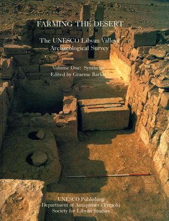
The project developed organically, involving over a dozen archaeologists, archaeological scientists and geographers as we needed to understand not just the chronology and morphology of settlement types but also the agricultural systems that had sustained them and the climate regimes in which they had developed, flourished, and declined. Two colleagues played particularly key roles in the field and laboratory studies and final publication. David Gilbertson led the work on climate, environment, and the floodwater farming systems that had sustained the Roman-period settlements. David Mattingly led the recording and analysis of the Roman-period settlement structures and the analysis of settlement patterns using Geographical Information Systems. The results of the project as it developed were reported in over 30 papers in Libyan Studies and the final results were published in two volumes entitled Farming the Desert: the UNESCO Libyan Valleys Archaeological Survey published jointly by UNESCO, the Libyan Department of Antiquities, and the Society (Barker et al. Reference Barker, Gilbertson, Jones, Mattingly and Barker1996a, Reference Barker, Gilbertson, Jones, Mattingly and Mattingly1996b). Though the bulk of the fieldwork was funded by UNESCO, the Society's support was critical in funding field activities that were not part of the core programme scheduled by UNESCO, and especially in the analytical work on the survey and excavation materials, as well as compiling the project archive on the completion of the project. The project developed before the use of GPS and satellite remote sensing (we had few maps, and a single black and white LANDSAT image of the survey area) and the survey conditions were challenging on many counts, but the project succeeded remarkably in its archaeological objectives given the circumstances, creating lasting friendships amongst the Anglo-Libyan team along the way.
The survey and mapping work, and study of the surface materials associated with archaeological structures, demonstrated that the gsur largely dated to the third and later centuries AD of the Roman period and followed on from a first major phase of settlement in the first and second centuries AD when sites were not fortified. These ‘open’ sites largely consisted of Roman-style farms and villas, but inscriptions on some of these, and on some gsur, indicated that the majority were built by the local tribal peoples of the pre-desert, not by Roman or Romanised limitanei or incomers from the coastal cities, so we termed them Romano-Libyan. Both the open farms and gsur had substantial water-storage cisterns and were associated with systems of drystone walls built across the wadi floors and along their margins that were recognisably examples of ‘floodwater farming’: surface-flowing floodwaters following rain storms were guided downslope into the wadis, their flow controlled by elaborate systems of sluices and slipways, and slowed down by the cross-wadi walls so that their nutrient-rich sediments were deposited on the wadi floors, renewing the fertility of the fields. Studies of the carbonised or desiccated plant remains found in middens by the farms indicated the cultivation of crops such as cereals, legumes, figs, olives and vines, and animal bones showed that cultivation was integrated with animal husbandry, especially of sheep and goats. Most of the farms had substantial stone structures that could be recognised as olive presses (Figure 2), and calculations of the capacity of these provided convincing evidence of surplus production of olive oil.
A Romano-Libyan olive press in the Trpolitanian pre-desert (as shown on the cover of Barker et al. Reference Barker, Gilbertson, Jones, Mattingly and Barker1996a, photograph: Barri Jones).

The ephemeral nature of the archaeological record prior to the development of the Romano-Libyan open farms implied forms of settlement not unlike the traditional mobile pastoralism-cum-agriculture described earlier for the Gebel Akhdar. We concluded that what we were observing in the Tripolitanian pre-desert was the sedentarisation of the local population and the development of surplus production in response to the new markets of the coastal cities such as Lepcis Magna. There was no evidence of a wetter climate in the palaeoecological data we collected, so the conclusion was that the new systems of intensive sedentary farming were able to function because of the use of floodwater farming technologies. The southernmost wadis always remained extremely marginal for this, however, and the dating of the sites demonstrated that farms here were swiftly abandoned, their occupants probably reverting to traditional lifeways, whereas floodwater farming systems survived into the Islamic centuries and beyond in the well-watered northern wadis.
The Cyrenaican Prehistory Project
A peripatetic research career took me from the Tripolitanian pre-desert back to the Italian countryside when I was Director of the British School at Rome in the 1980s, then to the Jordanian desert in the 1990s (Barker et al. Reference Barker, Gilbertson and Mattingly2007a) and surprisingly from there to the Bornean rainforest in 2000–2004. The focus of the latter project was the re-excavation of some of the entrances of Niah Great Cave, an extraordinary cathedral-like cavern in coastal Sarawak where Tom and Barbara Harrisson had conducted pioneering excavations in the 1950s and 1960s that yielded one of the most important deep occupation sequences in Southeast Asia spanning the Late Pleistocene and Holocene. When we started the project there was an ongoing debate amongst archaeologists and anthropologists about whether tropical hunter-gatherers could ever have lived in rainforest by foraging alone, as most rainforest hunter-gatherers in recent times trade with farmers, but we were able to demonstrate that rainforest in one form or another was always around the cave and that from the beginning of the sequence 50,000 years ago early modern humans had developed ingenious ways of exploiting it, in the process changing its character through activities such as burning and clearance (Barker Reference Barker2013; Barker and Farr Reference Barker and Farr2016). The adaptability and ‘plasticity’ of Pleistocene Homo sapiens in the face of climatic and ecological change demonstrated at Niah were at the forefront of my interests when I was invited by the Libyan Department of Antiquities in 2006 to re-excavate the Haua Fteah cave in Cyrenaica (Figure 3). What could this cave's deep occupation sequence tell us about the ‘behavioural plasticity’ (or not) of people in North Africa living through the same phases of global climatic change experienced by their rainforest contemporaries in the Late Pleistocene and Holocene but in this case characterised especially by fluctuations in aridity?
The Haua Fteah: (a) view of the cave, looking south; (b) schematic diagram of the McBurney trench and the CPP trenches; (c) view of the new excavations, looking southwest, showing Trench M under excavation (Illustration: Lucy Farr; photographs: Graeme Barker).

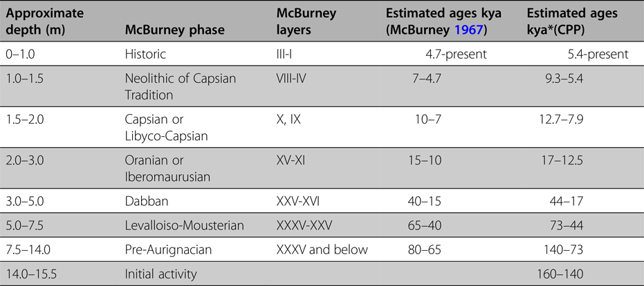
Based primarily on the typology and technology of the lithic material recovered, McBurney defined seven cultural phases of occupation in his 14 m-deep trench (McBurney Reference McBurney1967). The earliest phase was a Middle Palaeolithic industry of flakes and blades which he termed the ‘Pre-Aurignacian’ after similar industries in Southwest Asia. Next were ‘Levalloiso-Mousterian’ industries, so called from their broad comparability with Middle Palaeolithic Mousterian industries in the Levant and Europe. Two mandibles were found in these layers (McBurney et al. Reference McBurney, Trevor and Wells1953) that have since been identified as Homo sapiens (‘modern humans’) (Hublin Reference Hublin, Bar-Yosef and Pilbeam2000). There was then a marked change with the appearance of an Upper Palaeolithic blade technology that he termed ‘Dabban’ after the Cyrenaican cave of Hagfet ed-Dabba where he had found similar material (McBurney Reference McBurney1960). This was succeeded by a microlithic late or final Upper Palaeolithic (Epipalaeolithic) industry he termed ‘Eastern Oranian’ or ‘Iberomaurusian’ from its similarities with assemblages in the Maghreb. Above this was a Mesolithic-type microlithic industry with parallels to Capsian assemblages in the Maghreb and hence classified as the ‘Libyco-Capsian’. This was overlain by layers with Neolithic pottery and domestic sheep and goats termed ‘Neolithic of Libyco-Capsian tradition’ because of similarities in stone tools with the preceding Libyco-Capsian. The prehistoric sequence was capped by a substantial boulder-supported structure dating to the Graeco-Roman period covered by burnt animal dung and other evidence of animal enclosures dating to recent centuries.
The only means available to McBurney for dating this sequence was radiocarbon or 14C dating, which at the time had a maximum range of about 40,000 years before the present (today it is around 50,000 years). This allowed him to date the upper part of the sequence, from the beginning of the Dabban phase around 40,000 years ago, with reasonable confidence. The ages of the Levalloiso-Mousterian and Pre-Aurignacian assemblages in the c.9 m of sediment below the Dabban could only be estimated from calculations of rates of sedimentation. On this basis McBurney estimated that the earliest occupation began perhaps around 80,000 years ago.
We began the new project, which we termed the Cyrenaican Prehistory Project, in 2007. Having located the McBurney trench, which had been filled in at the end of the 1955 excavations, we gradually emptied it of backfill, recorded the cleaned faces in great detail and sampled them for materials for dating and for palaeoecological analysis, and excavated small trenches down its southern side (Figure 3). This work continued every year to 2013, with a cessation of fieldwork during the civil unrest that culminated in Gaddafi's death in October 2011 (Barker et al. Reference Barker, Hunt and Reynolds2007b, Reference Barker, Basell, Brooks, Burn, Cartwright, Cole, Davison, Farr, Hamilton, Hunt, Inglis, Jacobs, Leitch, Morales, Morley, Morley, Pawley, Pryor, Rabett, Reynolds, Roberts, Simpson, Stimpson, Touati and der Veen2008, Reference Barker, Antoniadou, Barton, Brooks, Candy, Drake, Farr, Hunt, Ibrahim, Inglis, Jones, Morales, Morley, Mutri, Rabett, Reynolds, Simpson, Twati and White2009, Reference Barker, Antoniadou, Armitage, Brooks, Candy, Connell, Douka, Drake, Farr, Hill, Hunt, Inglis, Jones, Lane, Lucarini, Meneely, Morales, Mutri, Prendergast, Rabett, Reade, Reynolds, Russell, Simpson, Smith, Stimpson, Twati and White2010, Reference Barker, Bennett, Farr, Hill, Hunt, Lucarini, Morales, Mutri, Prendergast, Pryor, Rabett, Reynolds and Twati2012; Farr et al. Reference Farr, Lane, Abdulazeez, Bennett, Holman, Marasi, Prendergast, Al-zweyi and Barker2014; Rabett et al. Reference Rabett, Farr, Hill, Hunt, Lane, Moseley, Stimpson and Barker2013) and again in 2014 and 2015, the excavations being completed by colleagues from the Libyan Department of Antiquities in 2016. The trench was backfilled again in 2017.
An extensive 14C dating programme on charcoal and shells from the new excavations confirmed the broad validity of McBurney's chronology for the Dabban and later phases, whilst also refining them (Douka et al. Reference Douka, Jacobs, Lane, Grün, Farr, Hunt, Inglis, Reynolds, Albert, Aubert, Cullen, Hill, Kinsley, Roberts, Tomlinson, Wulf and Barker2014; Hill Reference Hill2016). The sequence was further refined by five volcanic tephras, volcanic dust blown into the cave from well-dated volcanic eruptions in Italy and Greece. OSL (optically stimulated luminescence) dating of quartz grains, a method not available in McBurney's time, virtually doubled the age of the lower sediments in comparison with McBurney's estimates, dating the Levalloiso-Mousterian layers to 73,000–44,000 years ago, the Pre-Aurignacian to 140,000–73,000 years ago and basal cultural layers not found by McBurney to 160,000–140,000 years ago (Jacobs et al. Reference Jacobs, Li, Farr, Hill, Hunt, Jones, Rabett, Reynolds, Roberts, Simpson and Barker2017; Table 1). The sequence is therefore about twice as old as McBurney estimated.
The chronostratigraphy of the Haua Fteah according to the McBurney work (McBurney Reference McBurney1967) and the Cyrenaica Prehistory Project. ‘Kya’ signifies thousands of years ago; *refers to a 95.4 per cent probability of the age lying within the parameters shown (after Douka et al. Reference Douka, Jacobs, Lane, Grün, Farr, Hunt, Inglis, Reynolds, Albert, Aubert, Cullen, Hill, Kinsley, Roberts, Tomlinson, Wulf and Barker2014 and Jacobs et al. Reference Jacobs, Li, Farr, Hill, Hunt, Jones, Rabett, Reynolds, Roberts, Simpson and Barker2017).

This deep ‘archaeological history’ of the Haua Fteah developed against a background of profound climatic change. The major sedimentary phases or facies of the Haua Fteah, established by the CPP from field observations, bulk sedimentological analyses and micromorphology, broadly map onto the major phases of global climate change termed Marine Isotope Stages, from the latter part of MIS 6 to MIS 1 (Hunt et al. Reference Hunt, Davison, Inglis, Farr, Simpson, el-Rishi and Barker2010; Inglis et al. Reference Inglis, French, Farr, Hunt, Jones, Reynolds and Barker2017). At the same time, however, sedimentation and human activity were both highly episodic: careful excavation was able to define a succession of hiatuses of different lengths that are mostly devoid of evidence for the human use of the cave (Farr and Jones Reference Farr, Jones, Boyle, Rabett and Hunt2014). Most of these relate to phases of aridity.
The ephemeral earliest signs of occupation in Trench S at the base of the Deep Sounding date to the latter part of MIS 6, but the major phases of ‘Pre-Aurignacian’ activity broadly correlate with the periods of globally wetter and warmer climate denoted as MIS 5e, 5c and 5a (Jacobs et al. Reference Jacobs, Li, Farr, Hill, Hunt, Jones, Rabett, Reynolds, Roberts, Simpson and Barker2017). These were ‘Green Sahara’ phases in North Africa when there were lakes, rivers and grasslands where there is now desert (Drake et al. Reference Drake, Breeze and Parker2013). The Homo sapiens groups who used the cave in these humid phases were well adapted to living on the Cyrenaican coast: they fished and collected shellfish, collected land snails, probably collected fruits, nuts and seeds, and hunted animals including Barbary sheep, gazelle, aurochs (wild cattle) and hartebeest on the Gebel escarpment behind the cave that was in part well wooded at this time.
The next major cultural phase, the Levalloiso-Mousterian, in fact divides into two, one 73,000–65,000 years ago and the others dating to 50,000–44,000 years ago. The first phase, to which the two modern human mandibles belong, correlates broadly with MIS 4, a time of marked oscillations between warm/humid and cold/dry conditions. The second phase, in the first part of MIS 3, was also characterised by temperature oscillations though marked aridity was increasingly the norm. Levalloiso-Mousterian hunting and gathering technologies, and the social structures in which they were embedded, appear to have been poorly adapted to the challenges of living in drier and more open landscapes. The hiatuses in occupation in the cave imply that the Gebel Akhdar may have been abandoned at times of significant aridity within and especially between the two phases of Levalloiso-Mousterian activity (Reynolds Reference Reynolds, Boyle, Rabett and Hunt2014).
The Dabban also divides into two distinct phases, the Lower Dabban 44,000–30,000 years ago and the Late Dabban 22,000–17,000 years ago. Several strands of evidence point to significant developments in subsistence technologies that allowed people to deal with the developing arid landscapes more successfully than hitherto, including in the peak conditions of cold and aridity at the Last Glacial Maximum in the case of the Late Dabban. Microscopic evidence of use-wear and organic residues attached to tool surfaces indicate the development of hafted projectiles better adapted to hunting animals like Barbary sheep in open landscapes where ambush and close encounters were difficult. The age structures of the prey animals indicate all-year-round hunting. Post-holes in the cave might be from shelters but could also be from food processing activities such as meat drying racks. Isotope analyses show that the collection of shellfish was increasingly important (Prendergast et al. Reference Prendergast, Stevens, O'Connell, Fadlalak, Touati, Al Muzeni, Schone, Hunt and Barker2016a). A wide range of fruits, nuts, legumes and seeds was collected and stored (Morales Reference Morales2010), and processed on stone mortars for consumption (Barton et al. Reference Barton, Mutri, Hill, Farr and Barker2018). Seeds are low-ranked foods ethnographically because they take a long time to gather and prepare (they provide 500–750 kcal per hour compared with acorns providing 3000 kcal per hour and roots and tubers 6000 kcal) but are clearly extremely useful to bridge ‘hungry gaps’ of short-term resource stress. Surveys we conducted across the Gebel Akhdar demonstrated that settlement increasingly concentrated in the better watered more forested parts of the landscape (Jones et al. Reference Jones, Antoniadou, Barton, Drake, Farr, Hunt, Inglis, Reynolds, White, Barker, Jones and Stewart2016). Isotope analysis of land snails supports the conclusion that the Gebel Akhdar was a refugium for plants, animals and people at this time as the Sahara became desert (Prendergast et al. Reference Prendergast, Stevens, O'Connell, Hill, Hunt and Barker2016b, Reference Prendergast, Stevens, Hill, Barker, Hunt and O'Connell2017).
The use of the cave appears to have intensified significantly with deglaciation after the LGM, by people using Oranian or Iberomaurusian backed blade technologies that were increasingly microlithic. They hunted Barbary sheep (especially), and collected, stored and processed plant foods, as before, but there is also evidence for the increasingly intensive collection of terrestrial and marine and terrestrial molluscs, on an all-year-round basis in the case of the marine species (Prendergast et al. Reference Prendergast, Stevens, O'Connell, Fadlalak, Touati, Al Muzeni, Schone, Hunt and Barker2016a). Size changes in the marine and terrestrial molluscs indicate resource stress from overexploitation (Hunt et al. Reference Hunt, Reynolds, El-Rishi, Buzaian, Hill and Barker2011a).
There is widespread evidence across North Africa that the early Holocene was another phase of ‘Green Sahara’, but the bird bones, phytoliths (silica parts of plants) and other palaeoecological proxies from our excavations all indicate more muted climate changes around the cave, with open woodland dominating the landscape. Capsian technologies and subsistence activities were much like those of the Oranian (Lucarini and Mutri Reference Lucarini, Mutri, Boyle, Rabett and Hunt2014), though the cave was used more seasonally by people who presumably spent several months elsewhere in the Gebal Akhdar and perhaps on what is now the desert fringe but that would have been habitable then. About 8000 years ago, as marked aridity began to develop in North Africa, the herding of sheep and goats was incorporated into the subsistence base at the Haua Fteah, which otherwise remained a mix of hunting and gathering as in the Capsian (Lucarini et al. Reference Lucarini, Radini, Barton and Barker2016). There is no evidence in the pollen and archaeobotanical records for the cultivation of domestic plants until the Graeco-Roman era (Hunt et al. Reference Hunt, Brooks, Meneely, Brown, Buzaian and Barker2011b). It was only at that time that the present landscape of olives, vines, cereals and sheep/goat husbandry developed, bringing me back full circle to the models of traditional landscape use in the Graeco-Roman period constructed from the Sidi Khrebish fauna.
Conclusion
The three projects described here, all sponsored by the Society for Libyan Studies through the course of its 50-year history, have been very different in their focus but employed overlapping methodologies integrating humanities goals with archaeological fieldwork and archaeological science. They have provided intriguing insights into how the natural landscapes of Libya were transformed into cultural landscapes in different ways at different times by societies of different structures and complexities. They have shown the complexity of past societies’ responses to the constraints and opportunities of their environment, in the case of the Benghazi and Tripolitanian case studies in the context especially of changing political structures and in the case of the long ‘archaeological history’ of the Haua Fteah in the context especially of climate change. The principal linking finding is that there are no simple stories from the past in terms of people's relations to their landscape: the mix of structure and agency embodied in the archaeological record can be a record of failures, misguided decisions, bad luck etc. as much as of successful responses and adaptations to opportunities and challenges. The findings of all three projects have demonstrated the extraordinary richness of Libya's archaeological heritage, a unique resource in terms of its potential for research and public benefit and its relevance to significant questions about the history of North African and Mediterranean peoples, past, present and future.
Acknowledgements
I thank in particular the Department of Antiquities of Libya for its permissions to undertake the fieldwork projects discussed here, and their sustained commitment to supporting the projects. All the fieldwork permits were arranged by the Society for Libyan Studies, whose assistance in logistics and seed funding was vital to all three projects discussed here. The Cyrenaican Prehistory Project was from 2009 also termed the TRANS-NAP project from the acronym of the European Research Council grant to the author (Advanced Investigator Grant 230421: Cultural Transformations and Environmental Transitions in North African Prehistory), which provided major funding that is gratefully acknowledged. Funding was also provided to the CPP by the British Academy and the Radiocarbon Facility of the Natural Environment Research Council as well as by the Society for Libyan Studies. Much of the evidence discussed in this paper derives from the efforts of large multi-disciplinary teams, as will be apparent from the cited publications.