INTRODUCTION
Izapa followed a trajectory of settled life that began at the beginning of the second millennium b.c. in the Soconusco region of Chiapas and neighboring Guatemala (Figure 1). A series of Early Formative (1900–1000 b.c., all dates calibrated) centers characterize the Mazatán zone of the Soconusco region (Clark and Pye Reference Clark, Pye, Clark and Pye2000; Love Reference Love2007; Rosenswig Reference Rosenswig2010). The earliest centers—the best known of which is Paso de la Amada—formed a network of locally interacting chiefs and kings (Clark and Blake Reference Clark, Blake, Brumfiel and Fox1994). By 1400 b.c., elites in the Soconusco region engaged in long-distance relationships with the Gulf Coast Olmec; also at this time, the political center of the Soconusco region shifted to Cantón Corralito and, then, Ojo de Agua, located on the opposite side of the Coatán River (Cheetham Reference Cheetham, Halperin, Faust, Taube and Giguet2009, Reference Cheetham2010; Clark Reference Clark1997; Pye et al. Reference Pye, Hodgson, Clark and Lesure2011). The emergence of La Blanca as a regional center, at the other end of the Soconusco region, corresponded to the abandonment of the Mazatán zone by about 1000 b.c. (Blake and Clark Reference Blake, Clark and Blake1999:64; Love Reference Love2002a) and the depopulation of the Jesús River zone to the southeast (Pye Reference Pye1995; Pye and Demarest Reference Pye, Demarest and Fowler1991). This demographic concentration suggests that La Blanca attracted the surrounding populations to its environs (Love Reference Love and Blake1999a, Reference Love, Grove and Joyce1999b:90; Rosenswig Reference Rosenswig and Lesure2011, Reference Rosenswig2012a). The beginning of the first millennium b.c. also witnessed a fuller commitment than in the previous period to maize agriculture in the Soconusco region (Blake Reference Blake, Staller, Tykot and Benz2006; Blake et al. Reference Blake, Chisholm, Clark, Voorhies and Love1992; Clark et al. Reference Clark, Pye, Gosser, Lowe and Pye2007; Love Reference Love and Blake1999a; Rosenswig Reference Rosenswig2006; Rosenswig et al. Reference Rosenswig, VanDerwarker, Culleton and Kennett2015a) and the creation of large conical mounds as a standard feature of all political centers (Love Reference Love, Grove and Joyce1999b; Rosenswig Reference Rosenswig, Burger and Rosenswig2012b).
Map of Mesoamerica with sites mentioned in the text. Map by Rosenswig.

La Blanca became the most hierarchical polity that the Soconusco region had seen up until 1000 b.c. The capital city grew to cover over 300 hectares (Love Reference Love2002a; Love and Guernsey Reference Love, Guernsey and Lesure2011) and its 25-m-high pyramid was one of the largest mounds in Mesoamerica (Love Reference Love and Blake1999a, Reference Love, Grove and Joyce1999b). A suite of archaeological evidence indicates that a new level of social and political stratification was established (Love Reference Love and O'Donovan2002b, Reference Love, Love, de Hatch and Escobedo2002c; Rosenswig Reference Rosenswig2007, Reference Rosenswig2012a). La Blanca collapsed after a few centuries, and population declined in the immediate region. Its demise was a continuation of a millennium of political volatility characterized by a succession of polities coalescing and collapsing on the coastal plain (Love Reference Love and O'Donovan2002b, Reference Love2007, Reference Love, Love and Kaplan2011). This rise-and-fall sequence provided the context in which mounded architecture was adopted at Izapa sometime around 800 b.c. This center then flourished for the next millennium and a half, and this long-lasting occupation distinguishes Izapa from previous experimentation with complexity in the region (Lowe et al. Reference Lowe, Lee and Espinoza1982, Reference Lowe, Ekholm and Clark2013; Rosenswig and López-Torrijos Reference Rosenswig and López-Torrijos2018; Rosenswig and Mendelsohn Reference Rosenswig and Mendelsohn2016).
The Guillén phase (300–100 b.c.) represents the Formative-period political apogee of Izapa. By that time, Izapans had built 12 plazas through the construction of temple and platform mounds lined with hundreds of stone monuments (Lowe et al. Reference Lowe, Lee and Espinoza1982). Izapa's carved stelae contain complex narrative scenes, many of which carry assertions of political, economic, and ritual authority (Clark and Moreno Reference Clark, Moreno, Lowe and Pye2007; Duvalier Reference Duvalier1956; Guernsey Reference Guernsey2006, Reference Guernsey, Love and Kaplan2011, Reference Guernsey2012, Reference Guernsey2016, Reference Guernsey2018). The site's impressive architectural and sculptural achievements led scholars to speculate about the political power of the site's elite. Michael Love (Reference Love2007:291–292; Reference Love, Love and Kaplan2011) and Arthur Demarest (Reference Demarest2004:67) both posited that Izapa and other large sites along the south coast were urban political centers during the Late Formative period. The Izapa polity has been described as a kingdom, i.e., a hierarchically and regionally organized polity ruled by a succession of kings (Clark Reference Clark, Traxler and Sharer2016; Rosenswig and López-Torrijos Reference Rosenswig and López-Torrijos2018). By the Late Formative period, Izapa was the northernmost center of cities that extended down the Pacific coast and piedmont of Guatemala and included Takalik Abaj, El Ujuxte, El Baúl, Monte Alto, and Chocolá (Guernsey Reference Guernsey2012; Love and Kaplan Reference Love and Kaplan2011). On the Pacific coast of El Salvador, the sites of Chalchuapa (Sharer Reference Sharer1978), Santa Leticia (Demarest Reference Demarest1986), Quelepa (Andrews Reference Andrews1976), and Cara Sucia had also been built by this time.
This paper serves as an introduction to the Special Issue on Izapa. We begin with a review of work undertaken during the last six decades of the twentieth century. Next, we present more recent research from the first two decades of the twenty-first century. Each of the papers that follow presents new interpretations and/or new data that contribute to our evolving understanding of Izapa. Temporally, the papers encompass the millennium that stretches from the Middle Formative through the Middle Classic periods, from 700 b.c. to a.d. 600. They focus less on offering definitive conclusions and more on providing an update that builds upon more than 80 years of scholarly interest in this intriguing site's public monuments, monumental architecture, and interregional influence.
EARLY REPORTING AND INVESTIGATIONS AT IZAPA
Izapa's extraordinary corpus of sculpture garnered the attention of scholars in the early twentieth century. Ignacio Marquina (Reference Marquina1939:40) included a brief description of Izapa in his Atlas arqueológico de la República Mexicana, noting the presence of isolated sculpture, mounds, burials, and ceramics at the site. That same year, Carlos Culebro (Reference Culebro1939) described several of the monuments. Culebro's reconnaissance coincided with other brief visits to the site by Karl Ruppert of the Carnegie Institution in 1938 and Alfred V. Kidder in 1939 (Stirling Reference Stirling1943:61). No formal archaeological investigation of Izapa began, however, until Miguel Covarrubias sparked the imagination of Matthew Stirling, then Director of the Bureau of American Ethnology at the Smithsonian Institution, with descriptions of monuments that recalled the great stone sculpture at the Olmec site of La Venta.
Stirling, Marion Stirling, and National Geographic Society staff photographer Richard Stewart spent one week at Izapa in April of 1941, where they located more than thirty monuments. In his Stone Monuments of Southern Mexico, Stirling (Reference Stirling1943) commented at length on the style of the monuments at Izapa, suggesting that they, like those at Takalik Abaj and El Baúl in Guatemala and Tres Zapotes in Veracruz, were quite early in date. Stirling exercised caution in his assertion because, at this time, it had not yet been determined with any certainty if the Long Count dates inscribed on stelae at Takalik Abaj, El Baúl, and Tres Zapotes directly correlated with the Maya calendar. J. Eric S. Thompson (Reference Thompson1943, Reference Thompson1948) addressed the potential linguistic affiliations of the Izapa region, noting that Fray Alonso Ponce had, in his 1586 account of a journey through Chiapas, documented individuals speaking a language much like Zoque (see Navarrete [Reference Navarrete, Lee and Navarrete1978] for discussion of Ponce's coastal travel route). Thompson (Reference Thompson1943:108) nevertheless deferred to Stirling's earlier observation that “one must bear in mind that boundaries of art styles and languages do not necessarily coincide.”
Questions concerning the dating and cultural affiliations of Izapa monuments continued to mount, fueled by larger discussion of the Izapan style's temporal, stylistic, and geographically liminal role in the history of Mesoamerican art (Guernsey Reference Guernsey2006:43–73). Drucker (Reference Duvalier1948:154) posited Izapa's potential role as “the channel through which Olmec influences filtered southeastward from their source north of the Isthmus of Tehuantepec.” He excavated 12 trenches at the site, documenting the presence of Plumbate pottery, but also called attention to brown- and black-slipped sherds (now known to date to the Formative period) that “seemed different” (Drucker Reference Duvalier1948:154; also see Orellana Reference Orellana1951). Tatiana Proskouriakoff (Reference Proskouriakoff1950:183) summed up the mid-twentieth century situation quite well: “We know virtually nothing of the architectural remains of the site or its ceramics, and these should prove of absorbing interest.”
In 1956, Gareth Lowe (Reference Lowe1959) of the New World Archaeological Foundation (NWAF) collected a small sample of ceramics from a drainage canal at Izapa that represented an undisturbed Late Formative refuse deposit. Only a few years later, however, Lowe and J. Alden Mason (Reference Lowe, Alden Mason and Willey1965:201–202) bemoaned the lack of thorough investigations still plaguing the broader Pacific coast region. They nevertheless felt comfortable in identifying two major periods of occupation at Izapa, the first during the Late to Terminal Formative, and the second during the Late Classic period. Meanwhile, scholars interpreting art historical and epigraphic evidence from Izapa (and the greater region) continued to date the apex of Izapa's artistic productivity to the Late Formative period (Bernal Reference Bernal1969; Coe Reference Coe and Wauchope1965; Lowe Reference Lowe1965; Miles Reference Miles and Willey1965; Parsons Reference Parsons1967). The first systematic analyses of the sculptural corpus at Izapa appeared in the early 1970s (Norman Reference Norman1973, Reference Norman1976; Quirarte Reference Quirarte1973).
NWAF excavations were undertaken over four long field seasons during the first half of the 1960s. Susanna Ekholm (Reference Ekholm1969) published her M.A. thesis reporting the ceramic analysis from the Mound 30a excavations and defined a chronological sequence for Izapa from the Early and early Middle Formative periods (Barra through Duende phases). The archaeological understanding of Izapa as a political center, the arrangement and history of its architecture, the placement of its stelae, altars, and thrones as well as the ceramic chronology has long been derived from Lowe et al.’s (Reference Lowe, Lee and Espinoza1982) NWAF publication. This single monograph, which was only intended as an introduction to the project, has long performed some heavy-lifting for understanding Izapa. The main goal of the NWAF excavations “was to determine the chronological and architectural relationships of the carved stone monuments” (Lowe et al. Reference Lowe, Lee and Espinoza1982:308), and their volume presents ceramic evidence for the Guillén-phase erection of the majority of monuments in lower Izapa. More limited excavations in the 1990s by Mexico's Instituto Nacional de Antropología e Historia (Gómez Rueda Reference Gómez Rueda, Laporte and Escobedo1995, Reference Gómez Rueda, Laporte and Escobedo1996; Gómez Rueda and Grazioso Sierra Reference Gómez Rueda, Sierra, Laporte and Escobedo1997) resulted in the discovery of over two dozen new monuments at the site and included discussion of the site's hydraulic system. In spite of these many efforts, questions still linger as to whether sculpture was carved only during the Guillén phase or continued to be produced throughout the Hato and Itstapa phases (100 b.c.–a.d. 300). Monuments were clearly reset at Izapa by later occupants who, during the Late and Terminal Classic period, relocated a number of carvings north to Group F.
RECENT INTERPRETATIONS AND NEW WORK AT IZAPA
A new phase of interpretation of Izapa's public art program has taken advantage of Norman's (Reference Norman1973, Reference Norman1976) presentation and extensive discussion of the carved monuments at the site. Guernsey's (Reference Guernsey2006) book, based on her 1997 dissertation, explored the Late Formative Izapa style as a visual lingua franca that transcended linguistic boundaries of the Mixe-Zoque on one side and the Maya on the other. Guernsey focused her analysis on the leitmotif of bird-costumed rulers as epitomized by Izapa Stela 4, arguing that monuments such as this articulated a system of divinely sanctioned political authority whose iconography was shared by numerous polities throughout much of Late Formative Mesoamerica. Guernsey's (Reference Guernsey2006, Reference Guernsey, Guernsey, Clark and Arroyo2010, Reference Guernsey, Love and Kaplan2011, Reference Guernsey2012, Reference Guernsey2016) publications situated Late Formative monumental expressions within matrices of political and economic exchange, which were often framed in terms of pan-Mesoamerican mythic narratives.
Guernsey's (Reference Guernsey2018) paper in this Special Issue focuses on the portrayal of captive sacrifice on Stela 21 and contextualizes this imagery amidst other sculptural expressions of aggression known from the south coast and adjacent Guatemalan highlands. Stelae 21 depicts the decapitation of an elaborately dressed individual, rendered in graphic terms. Guernsey discusses the political significance of depictions of violence, arguing that Stela 21 functioned as part of a new, Late Formative iconographic tradition designed to frame images of violence, political subordination, and allegiance as key components of social order. Such public imagery linked assertions of social and political order to cosmological processes and was key to the formulation of new messaging designed to signal the relative safety that urban centers provided to those who submitted to their political authority.
Strauss's (Reference Strauss2018) contribution also addresses sculpture at Izapa and emphasizes its place in nascent Mesoamerican writing systems. While few hieroglyphs appear on Izapa monuments, Strauss argues that elites at the site participated in a uniquely Late Formative era of visual-verbal experimentation that transpired throughout the Zapotec, Epi-Olmec, and Maya regions. She proposes that calendrical expressions, potential nominal phrases, and “iconoglyphs,” repetitive visual elements, were often embedded in regalia, headdresses, or the terrestrial and celestial registers that frame many of the scenes on the monuments, all of which functioned within a meaningful system of communication. Strauss argues that, although monuments at Izapa attest to a primarily “text independent communicative strategy” that favored visual narratives over writing, elites were nevertheless engaged with the textual practices explored more fully at both neighboring and more distant sites.
The contribution by Pool, Loughlin, and Ortiz Ceballos (Reference Pool, Loughlin and Ceballos2018) to this Special Issue explores the nature of interaction between Late Formative polities on either side of the Isthmus of Tehuantepec. They present a detailed comparison of ceramic vessel decoration at both Izapa and Tres Zapotes during the last seven centuries b.c. and also address the formal and iconographic relationships between publicly displayed monuments from both sites. They note that Izapa's Guillén-phase ceramics show more similarity with the preceding Frontera phase than with Tres Zapotes’ Late Formative Huayapan-B-phase vessel decoration; they likewise argue that Guillén-phase ceramics from Izapa bear little relationship to ceramics made during Tres Zapote's Protoclassic (or Terminal Formative) Nextepotl phase or from contemporaneous sites in the Maya region. Rosenswig thinks that Pool and Laughlin’s surprise, at how poorly Hueyapan B lines up with Guillén, is a matter of mistaken cross-dating because the Frontera and Guillén phases at Izapa should be lined up with the Tres Zapaotes Hueyapan A phase, dated to 400–200 b.c. At Izapa, the distinctive everted rims (with grooves on top) begin in the Middle Formative with the Escalón Nicapa group (Lowe et al. Reference Lowe, Ekholm and Clark2013:Figure 11), continue with the wider everted rims characteristic of Mundet Red group during the Frontera phase (Lowe et al. Reference Lowe, Ekholm and Clark2013:Figure 23a), and evolve seamlessly into identical forms of the diagnostic Tuzantan type of the Late Formative Guillén phase (Lowe et al. Reference Lowe, Ekholm and Clark2013:Figure 27).
Public sculptures were used much longer than clay pots as demonstrated by Pool et al.’s (Reference Pool, Loughlin and Ceballos2018) interesting discussion of Tres Zapote's Stela C as having a 600-year-long history of recarving, movement, and changing uses. The “Izapan style” narrative stelae at Izapa were first carved during the Guillén phase but the question is whether the style persisted unchanged through to the Terminal Formative (Itstapa phase, a.d. 100–300), or if later occupants reset earlier monuments. At Izapa, this was evidently the case during the Late and Terminal Classic period when such monuments were moved to Group F.
During the past decade, John Clark has brought to completion much of the NWAF work at Izapa undertaken, but left unpublished, by project members from previous years (Clark and Lee Reference Clark and Lee2013; Lowe et al. Reference Lowe, Ekholm and Clark2013; Navarrete Reference Navarrete2013). Manuscripts begun by Lowe and other colleagues had languished 50–80 percent complete for decades, with sections of text written and most of the figures drafted. Rosenswig remembers when Clark placed over twenty manuscripts (concerning Izapa and Chiapa de Corzo), each in their own drawer in his second-story bedroom at the NWAF research center in San Cristobal de las Casas, to await completion and publication. Each manuscript contained data, drawings, and notes left by Lowe, Lee, and others from their work undertaken in the 1960s, 1970s, and 1980s. It is a testament to Clark's tenacity that these manuscripts have now begun to be published (with others on the way), and fortuitous that reanalysis of NWAF materials from Izapa has coincided with the Izapa Regional Settlement Project initiated by Rosenswig.
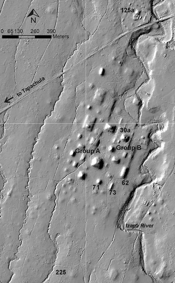
In their contribution to this Special Issue, Rosenswig et al. (Reference Rosenswig, Culleton, Kennett, Lieske, Mendelsohn and Nunez-Cortez2018) present the results from excavations undertaken at lower Izapa in 2012. The original center of Izapa (Group B) was established in the Middle Formative period, and the new excavations were undertaken both north and south of this plaza group (Figure 2). These excavations date the northern expansion of the site's main platform (under Mound 30a) to the Terminal Formative Itstapa phase (a.d. 100–300). The recent work also documented a white clay surface, built during the Middle Formative Escalón phase and used until Guillen times, and buried below the Terminal Formative platform expansion. Such dating of the platform, into which El León (Miscellaneous Monument 2) was set, is consistent with Navarrete's (Reference Navarrete2013:21–31) analysis of the associated ceramics dating to the Frontera phase and that stylistically it is an early sculpture (Guernsey Reference Guernsey2006:33–34; Lowe Reference Lowe1965:57; Norman Reference Norman1976:258). Two episodes of Guillén-phase monumental construction were recorded in association with long, linear Mound 62, which defines the eastern edge of Izapa's site core. Buried below the construction fill of Mound 62 was a hearth feature and stone alignment dated to the late Middle Formative based on radiocarbon assays and the results of ceramic analysis. Excavations at Mounds 72 and 73 established that Izapa's E-Group, first recognized with lidar data presented in Rosenswig et al. (Reference Rosenswig, López-Torrijos, Antonelli and Mendelsohn2013), was established in the late Middle Formative period and then significantly augmented during the Guillén phase. These excavations have also identified additional public and domestic spaces in lower Izapa, and provided a glimpse of feasting practices. Equally significantly, 10 new accelerator mass spectrometry (AMS) dates have confirmed Lowe et al.’s (Reference Lowe, Ekholm and Clark2013:Figure 2) initial dating of the Guillén phase to 300–100 b.c. Detailed ceramic analyses from these excavations have identified public and more domestic spaces at lower Izapa and provide a glimpse of feasting practices.
Lidar hillshaded digital elevation model of Izapa indicating mounds and mound groups mentioned in the text. Image by Rosenswig.

During the final century b.c., after six or seven centuries of relative stability, major changes occurred to the organization of Izapa. As Lowe et al. (Reference Lowe, Lee and Espinoza1982:308) long ago hypothesized, at some point before a.d. 100 an eruption of Tacaná volcano led to a disruption of Izapa's growth, which impacted the long-standing heart of the city in lower Izapa. Rather than a thriving political and economic center, lower Izapa was transformed into a more sacred/religious space (Lowe Reference Lowe1993). Rosenswig and Mendelsohn (Reference Rosenswig and Mendelsohn2016:Figure 4a) have reported very limited occupation of lower Izapa during the Hato phase (100 b.c.–a.d. 100), which corresponds to the period in which construction began to the north in upper Izapa around Group F. Macias et al.’s (Reference Macías, Espíndola, García-Palomo, Scott, Hughes and Mora2000) dating of the Tacaná eruption to the Hato phase is consistent with these archaeological patterns. In their contribution to this Special Issue, Macías and colleagues (Reference Macías, Arce, Capra, Saucedo and Núñez2018:Figure 2a) present nine new radiometric dates associated with the eruption that have a modeled age range of between 30 b.c. and a.d. 80. This dating indicates that the end of the Guillén phase may correspond with this calamitous volcanic event. As Macías and colleagues describe, the pyroclastic flows descended to within 7 kilometers of the center of Izapa and blanketed the site in ash, clogging all of the local rivers which would have soon overflowed and violently flooded. Macias et al. (Reference Macías, Espíndola, García-Palomo, Scott, Hughes and Mora2000) previously postulated that this eruption caused Hato-phase political disruptions at Izapa; their new paper models the ensuing flood event and suggests and that a 6-m-high wave of muddy water may have coursed through the city center.
Following this tumultuous event, when the primary occupation at Izapa shifted north to Group F, a number of earlier stelae were relocated to this more northerly plaza. The IRSP determined that mounds extending out from Group F and covered as much as three times the area previously reported by the NWAF (Rosenswig et al. Reference Rosenswig, López-Torrijos, Antonelli and Mendelsohn2013:1504). This includes dozens of newly documented residential mounds and a large elite mound complex beyond the area mapped by the NWAF (Rosenswig and Mendelsohn Reference Rosenswig and Mendelsohn2016:Figure 3, S2). Mendelsohn's (Reference Mendelsohn2017) dissertation research, focused on the period between 100 b.c. and a.d. 400, concentrated on the centuries following Izapa's Formative-period apogee and the disruption caused by the Tacaná eruption. In her contribution to this Special Issue, Mendelsohn (Reference Mendelsohn2018) presents excavation data from the area south of lower Izapa and questions Lowe et al.’s (Reference Lowe, Lee and Espinoza1982:139, 194) hypothesis that the Hato phase witnessed an intrusion by an outside ethnic group. She proposes, instead, that increased participation in trade networks for elite goods and a transformation in the institution of kingship at Izapa resulted in changes visible in the material record. Mendelsohn notes that Lowe et al. (Reference Lowe, Lee and Espinoza1982) originally established the Hato ceramic phase based solely on the urn burials and offerings at Mound 30; her research expands what we know of the Hato-phase ceramic assemblage by documenting domestic deposits for the first time. One such deposit at Mound 225 is associated with an AMS date of 51 b.c.–a.d. 130 (Mendelsohn Reference Mendelsohn2018:Table 1), which is consistent with the Hato phase lasting from 100 b.c. to a.d. 100.
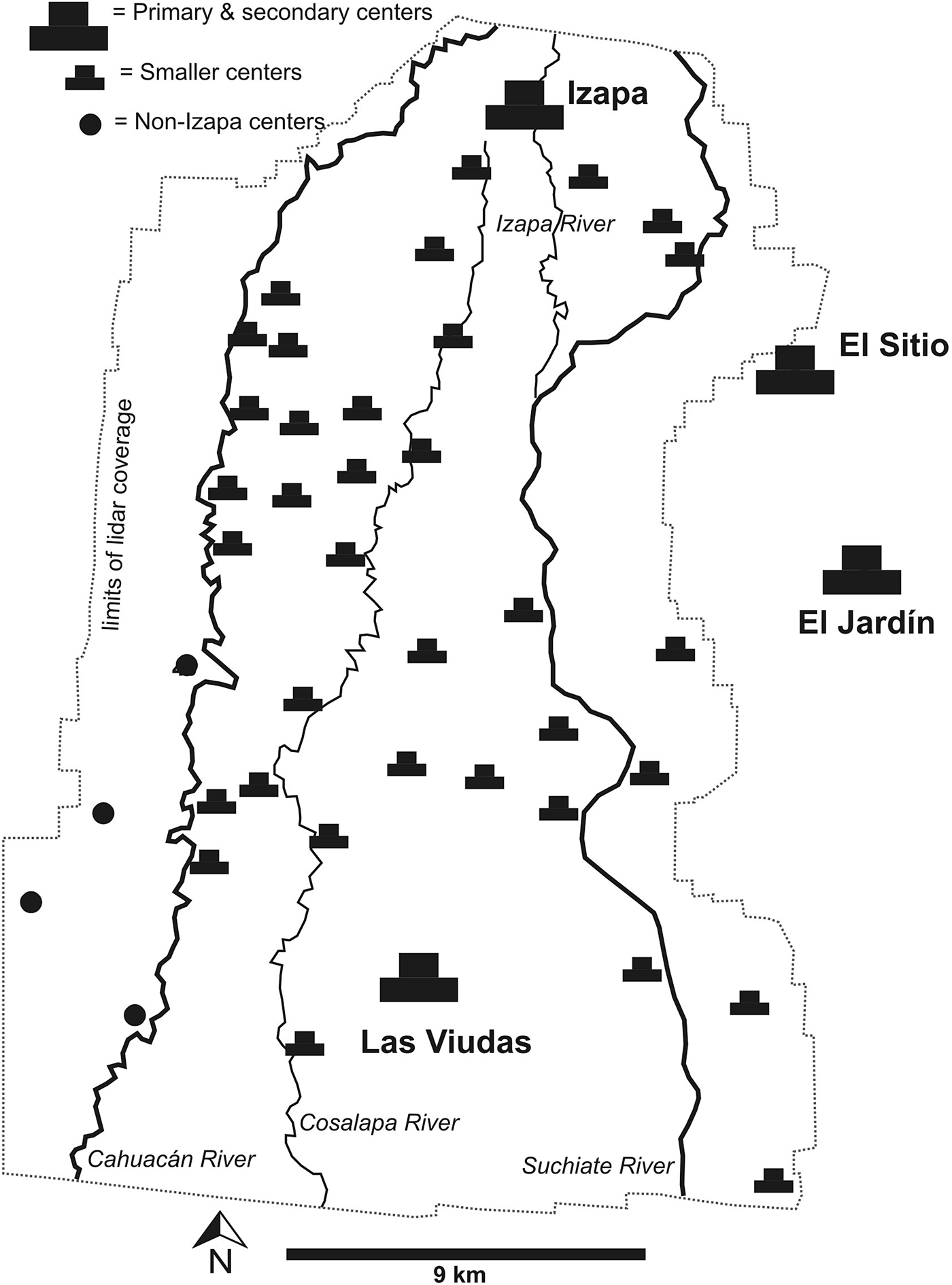
Map of the Izapa kingdom (based on Rosenswig and López-Torrijos Reference Rosenswig and López-Torrijos2018:Figure 3). Map by Rosenswig.

Lieske's (Reference Lieske2018) contribution, based on her M.A. research, presents a reanalysis of NWAF documentation of mortuary patterns from the south side of Mound 30a. A single individual from the Late Formative period, nine from the Terminal Formative, and two early Classic burials are virtually the only ones known from lower Izapa (the only other is the interment of a single individual at Group G). The acidic soils at Izapa result in virtually no bone preservation and the sole Late Formative interment is inferred to have existed in a crypt formed by a single row of cut stones associated with Guillén-phase remains (Lowe et al. Reference Lowe, Lee and Espinoza1982: 194, Figure 7.9). From the Hato phase, nine urn burials are documented in Mound 30d, a low platform immediately south of Mound 30a, that rises 16 m above the platform. Despite the political disruption caused by volcanic activity at this time, and the fact that monumental construction activity had shifted north to Group F, a few individuals were nevertheless interred in Mound 30d. These two burials were located along the centerline of Mound 30a and accompanied by Usulután ceramic vessels as well as jade beads and earspools (Lowe et al. Reference Lowe, Lee and Espinoza1982:191–194). These foreign ceramic types have not been found in nonburial contexts at Izapa and therefore appear to have served a distinct mortuary purpose (Lowe et al. Reference Lowe, Lee and Espinoza1982:180). Two more urn burials were interred in Mounds 30b and 30e during the Early Classic Jaritas phase, long after all building activity had ceased at lower Izapa. The ceramic grave accoutrements interred with these two individuals were of local types. Lieske's (Reference Lieske2018) article considers the evidence at Izapa in light of mortuary patterns at El Ujuxte, Takalik Abaj, and Kaminaljuyu and, among other things, points out that, though known from other Pacific coast sites, burying individuals in urns is unique to Izapa among the four centers. The urn-burial tradition at Izapa persisted for the next millennium and may explain why no royal tombs have been discovered at Izapa, in spite of the fact that the NWAF's excavations almost completely dismantled Mound 30a.
In their contribution, Clark and Lee (Reference Clark and Lee2018) turn to the Middle Classic period and consider green obsidian objects found in two burials in Izapa's Mound 125 platform complex (see Figure 2). Of the six Kato-phase (a.d. 400–500) burials, they describe Burial F-52, interred within an urn that contained 1,158 beads made from pressure-flaked obsidian blade segments from the distinctive green Pachuca source as well as tubular coral beads and a jade pendant. The urn was surrounded by 15 other ceramic vessels designed to serve food in small portions, as well as jade and shell objects for personal adornment. As discussed by Lieske (Reference Lieske2018), urn burials were a tradition at Izapa that began during the Hato phase many centuries before those documented at Group F. Burial F-52 was dug into the platform of Mound 125, constructed during the previous Jaritas phase. Of eight Loros phase (a.d. 500–600) burials known from Izapa, they describe Burial F-30, which contained 27 ceramic vessels used for serving liquids (four of which were imported from the Maya lowlands) along with a laurel-leaf biface made of Pachuca obsidian and as a variety of other stone and mineral inclusions. An urn was also included with the burials, but no bones were deposited within. Rather than status, the diversity of materials and their arrangement suggest to the authors that the arrangement was a symbolic representation. Clark and Lee (Reference Clark and Lee2018) describe these objects made from Pachuca obsidian as evidence of the “light touch” of Teotihuacan at Izapa and the result of emulation of pan-regional norms rather than direct involvement of the distant state. They further postulate that mounds newly discovered north of Group F by the IRSP may represent the population whose elite burials they describe. As domestic remains from these phases have not been identified (Rosenswig and Mendelsohn Reference Rosenswig and Mendelsohn2016:Figure 4), however, this poses a puzzle left to solve with future work.
Regional Patterns of the Formative-period Izapa Kingdom
Most interest in Izapa has focused on the large mounds and elaborate sculpture for which the site is rightly famous. Until very recently, however, virtually nothing was known of the regional structure of the Izapa polity. Rosenswig initiated the IRSP in 2011 to define regional patterns associated with the Formative-period Izapa polity. Three survey zones between the Cahuacán and Suchiate rivers were systematically documented. Within the low hills and piedmont zones, lidar mapping documented all mounds measuring more than 50 centimeters in height and the periods of their occupation were determined on a phase-by-phase basis (Rosenswig et al. Reference Rosenswig, López-Torrijos, Antonelli and Mendelsohn2013, Reference Rosenswig, López-Torrijos and Antonelli2015b). In the coastal plain survey zone, hectares of occupation were also recorded on a phase-by-phase basis (Rosenswig Reference Rosenswig2008). Settlement data from these three survey zones provide the basis for the quantitative reconstructing of population changes in the region as well as the movement of the majority of the population from the coastal plain to the piedmont and low hills after 700 b.c. An additional campaign of lidar data collection in 2015 brought the total coverage to almost 600 km2 and documented 40 lower-order monumental centers that were occupied during the Escalón, Frontera and Guillén phases (Rosenswig and López-Torrijos Reference Rosenswig and López-Torrijos2018). These regional data have enabled reconstruction of the internal spatial organization of the polity for the first time (Figure 3). It is now clear that, by the Escalón phase (700–500 b.c.), Izapa was the capital of a regionally organized polity, consisting of dozens of monumental centers that each employed the same site planning principles (Blake et al. Reference Blake, Rosenswig and Waber2015; Rosenswig et al. Reference Rosenswig, López-Torrijos and Antonelli2015b), and reflected a complex administrative hierarchy (Rosenswig and López-Torrijos Reference Rosenswig and López-Torrijos2018). Sites built according to the Izapa pattern possess mounds that form multiple plazas arranged in a roughly north-south alignment. A large pyramid sits a atop a platform at the northern end of each site, with an E-Group at the southern end. The pattern shares some characteristics with Clark and Hansen's (Reference Clark, Hansen, Houston and Inomata2001) Chiapas Middle Formative pattern (Lowe Reference Lowe and Adams1977). The Izapa kingdom centers were spread over an area of at least 450 km2 with the largest centers defensively arranged around the perimeter of the kingdom's territory (see Figure 3).
The contribution to this Special Issue by Neff et al. (Reference Neff, Burger, Culleton, Kennett and Jones2018) constitutes a complementary piece of the larger regional puzzle. Neff's survey and excavations in the estuary south of Izapa provide new evidence from this important resource-procurement zone. Their work has documented human activity in the estuary by 4000 b.c. during the Late Archaic period. After 1000 b.c., with the rise of the La Blanca polity, salt began to be harvested from this zone using the sal cocida technique of boiling down estuary water (see Andrews Reference Andrews1983:62–63). Neff and colleagues documented firing features and distinct coarse-ware ceramics, although the lack of a full assemblage of Middle Formative ceramic vessel forms indicates that salt production was a specialized activity and that the estuary zone was an extension of the regional settlement concentrated inland. Salt consumption at this time must have increased due to the dietary requirements associated with increased reliance on maize (Rosenswig et al. Reference Rosenswig, VanDerwarker, Culleton and Kennett2015a). Three to four times as many sites were documented during the late Middle and Late Formative period Bermudez complex (450–100 b.c.) than at any other time during the Formative period (Neff et al. Reference Neff, Burger, Culleton, Kennett and Jones2018:Figure 5). Archaeological remains from this period consisted of open-mouth ceramic vessels, firing pits and relatively few other artifacts, indicating continuity in specialized salt production had expanded to a much greater scale than before. Expanded salt production thus corresponds to the zenith of the Izapa kingdom. Sediment core data presented by Neff et al. (Reference Neff, Burger, Culleton, Kennett and Jones2018) also indicate that mangrove wood was being burned for fuel during the Bermudez complex. Occupation in the estuary then decreased significantly during the Terminal Formative Soledad phase (a.d. 0–250), when Izapa was experiencing volcano-induced political problems (Macias et al. Reference Macías, Arce, Capra, Saucedo and Núñez2018; Mendelsohn Reference Mendelsohn2018).
FUTURE INVESTIGATIONS
Izapa's history is a long and complicated one, filled with both intriguing patterns of continuity and perplexing ruptures that are not yet fully understood. The papers in this Special Issue offer new insights into lingering questions, present new data, and revisit issues that have guided investigation of Izapa for nearly a century. These papers by no means represent the final word concerning Izapa proper, the larger regional polity, or the many interregional dynamics. They do, however, present new data and interpretations derived from ongoing archaeological investigations at Izapa and related sites, as well as from continued examination of the rich body of imagery from stone sculpture. There is still much to learn about Izapa and issues requiring future investigation include the following:
(1) Izapa's Relationship to the La Blanca Polity
Currently Love (Reference Love2007:Figure 3) dates the Conchas phase at La Blanca to 1000–600 b.c. with four sub-phases, whereas Clark dates it at Izapa to 1000–850 b.c., followed by the Duende phase, which lasts from 850 to 700 b.c. (Lowe et al. Reference Lowe, Ekholm and Clark2013:Figure 2). Love's chronology implies that occupations at La Blanca and Izapa overlapped in time, whereas Clark's implies that La Blanca's collapse and Izapa's ascension coincided and were likely related. Rosenswig (Reference Rosenswig2010) has clear Conchas-phase remains at Cuauhtémoc and defines the Conchas phase to 1000–800 b.c. and as being part of a pan-Mesoamerican ceramic horizon, defined by a predominance of white wares and the double-line break motif as well as decoration executed with post-slip incision. But he would not argue about a radiometrically defined ceramic phase's limit being pushed around by 50, 75, or even 100 years (and so, could agree with ending the Conchas phase at 700 b.c.). Rosenswig saw most of the Izapa ceramic materials housed at the NWAF while Clark was undertaking his reanalysis for the Lowe et al. (Reference Lowe, Ekholm and Clark2013) monograph, and he observed surprisingly little of what he would identify as Conchas-phase sherds based on his experience with Cuauhtémoc assemblages. He has also recently identified Duende in his analysis of settlement patterns and excavations at Izapa (Rosenswig et al. Reference Rosenswig, Culleton, Kennett, Lieske, Mendelsohn and Nunez-Cortez2018). Rosenswig sees Izapa's rise as following La Blanca's demise, the latter conceivably having been a slow process during which La Blanca remained occupied while subsidiary centers like Cuauhtémoc were abandoned and populations were drawn into the new Izapa phenomenon. Determining the timing and nature of the political transition from La Blanca to Izapa will likely require new archaeological evidence from sites other than the two capital cities.
(2) Structure of the Izapa Kingdom during the Escalón, Frontera, and Guillén Phases
The IRSP has documented the spatial extent of the Formative-period Izapa kingdom. Preliminary reporting, however, provides a synchronic presentation of the six centuries (700–100 b.c.) of the polities rule during the Escalón, Frontera, and Guillén phases (Rosenswig and López-Torrijos Reference Rosenswig and López-Torrijos2018). These patterns are temporally coarse as they are based on surface collections from the 40 newly identified political centers that have their architecture defined by lidar. Future excavations at some of these lower-order centers will be required to provide a more fine-grained picture of the larger Izapa kingdom, how it rose and solidified its local dominance, and what economic dynamics fueled its political, architectural, and artistic accomplishments.
(3) The Collapse and Reorganization of Izapa during the Hato Phase
The issue of Hato-phase disruption, which concerns the shift in architectural construction from lower Izapa to Group F during the final century b.c., has long garnered attention. Lowe (Reference Lowe1993) originally proposed that lower Izapa became a shrine center during the Terminal Formative period. Work by Macias et al. (Reference Macías, Espíndola, García-Palomo, Scott, Hughes and Mora2000, Reference Macías, Arce, Capra, Saucedo and Núñez2018) makes clear that Tacaná’s eruption impacted the site and that this dramatic event occurred at some point between the last century b.c. and first century a.d., or coincident with the archaeological definition of the Hato phase. Mendelsohn's (Reference Mendelsohn2018) excavations and those revisited by Clark and Lee (Reference Clark and Lee2013:97–115) as well as Lieske (Reference Lieske2018) demonstrate, however, that lower Izapa was not completely abandoned even after its role as the locus of political activity and mound construction declined. What was the function of lower Izapa during the Hato and Itstapa phases? And, for that matter, what precisely was the role of Group F and upper Izapa during these centuries? Did the same line of kingly succession reinvent itself after the Tacaná eruption by shifting new efforts to Mound 125 and Group F? Or did a usurper establish and define a new political regime? Was there a two-century-long dissolution of authority during the Hato phase, which was reconstituted during the Itstapa phase from a.d. 100–300 when monumental construction resumed?
(4) The Timing of the Cessation Stelae Carving at Izapa
This issue is related to the previous one. Were stone monuments carved only during the Guillén phase as Lowe and colleagues (Reference Lowe, Lee and Espinoza1982) proposed, or did they continue to be produced into the Terminal Formative Hato and/or Itstapa phase(s)? This question impacts Inomata et al.’s (Reference Inomata, Ortiz, Arroyo and Robinson2014) call for a revised chronology for low relief monuments across southern Mesoamerica (and see Love Reference Love2018). For how many centuries were similarly decorated stelae produced? Most of Izapa's stelae were stratigraphically documented in Guillén-phase contexts by the NWAF (Lowe et al. Reference Lowe, Lee and Espinoza1982:133) and subsequent work confirm the dating of this phase to 300–100 b.c. (Rosenswig et al. Reference Rosenswig, Culleton, Kennett, Lieske, Mendelsohn and Nunez-Cortez2018). These subsequent excavations, however, also establish that stelae were erected on the west side of the Mound 30 platform from a.d. 100–300. So, could the stelae have been produced for six centuries (i.e., Guillén through Itstapa phases)? Or were they only made during the first two centuries and then moved around for a few more? Further, if Inomata et al.’s (Reference Inomata, Ortiz, Arroyo and Robinson2014) reassessment of the Kaminaljuyu dates is correct, could stelae carved in this distinctive manner been adopted elsewhere only during the final centuries of their production at Izapa?
(5) Nature of Early Classic Organization of Izapa
Regional settlement survey data suggest that virtually no population inhabited the area around Izapa or in the neighboring Naranjo River zone between the years of a.d. 400 to 700 (Love Reference Love2007:298; Rosenswig and Mendelsohn Reference Rosenswig and Mendelsohn2016:Figure 4). During these three centuries, elites at the centers of Los Horcones (Garcia-Des Laurier Reference Garcia-Des Lauriers2007) and Iglesia Vieja (Kaneko Reference Kaneko, Laporte, Arroyo and Escobedo2011) to the northwest and Montana (Bove and Mendrano Busto Reference Bove, Busto and Braswell2003) to the southeast forged ties with the center of Teotihuacan. The two burials reported by Clark and Lee (Reference Clark and Lee2018) thus require explanation. Was Izapa a pilgrimage site during this era? Or was there a local population that has yet to be defined? These questions, and others relevant to the site's long occupation, will surely require many academic lifetimes to explore.
ACKNOWLEDGMENTS
Our thanks to Bill Fowler, Bruce Bruschi, and Lauren Marra for all of their help ushering the papers in this Special Issue through the submission, review, and revision processes. Michael Love is also thanked for reading an earlier version of this paper.