Introduction
The property market is increasingly recognized as an important component of the medieval urban economy, which has the potential to be investigated using a variety of methodologies. Archaeological evidence and geographical mapping techniques have reconstructed medieval topographies, increasing our understanding of the scale of medieval towns, their residential and commercial building and their infrastructure.Footnote 1 Documentary evidence has established the identities of owners and tenants and explained how property was bought, sold, exchanged and leased.Footnote 2 Together, this body of work has highlighted processes that drove and shaped urban property markets.
This article examines whether property rents varied within towns. Scholars have been deterred from analysing medieval urban rents because of a belief that they were ‘fossilized’ from an early stage in town development, and therefore did not reflect economic forces that guided the later development of towns.Footnote 3 This is in contrast to work on medieval and early modern agricultural rents which has used statistical techniques to analyse rent levels and their relationship to land and property characteristics.Footnote 4 One reason for the difference is that statistical research into rents requires documentary sources recording a relatively large number of properties and providing relevant details on each property. Unfortunately, there is limited survival of such sources for medieval European towns; many have no surviving records, while in others the records contain insufficient detail to explain the variation of rents across properties. Rent rolls and deeds are the two main types of documentary sources available. Rent rolls were usually compiled by an institution, to record the properties owing rent to them. As such, their coverage is often restricted to the properties from which the institution received rent, rather than all the properties in a town.Footnote 5 Deeds were produced when a property was transferred between individuals or between individuals and institutions and often contain detailed information on property characteristics and the identities of owners. However, because different properties were often transferred at different times, the data contained in deeds relates to different points in a property's history, making statistical comparisons of rent levels across properties in a given location difficult.Footnote 6
A second reason why statistical techniques have not often been applied to medieval sources is that it has often been assumed that all rents in boroughs were set at a uniform level and remained ‘fossilized’ through subsequent decades or centuries at the level at which they were set when the town was founded.Footnote 7 While some towns, such as Grimsby, show evidence of uniform and fossilized rents, this was not the case in all towns.Footnote 8 New Winchelsea shares similar characteristics to Hull, as it is an example of a newly created royal port with a rental that was drawn up at the early stages of development under royal authority. The 1292 rental of burgage plots in New Winchelsea also shows that rents of plots varied between different parts of the town.Footnote 9 For the older town of Gloucester, meanwhile, the rental of 1455 records two sets of rents; one set in c. 1100 and the other set in c. 1455. The levels of both sets of rents were influenced by the location of property and its use.Footnote 10
One town with excellent sources is the port of Hull in north-east England, which assumed international significance in the fourteenth century as a military logistical centre and trading port for the export of English wool and cloth to the Low Countries. Unlike other major ports, such as London, Bristol and Gloucester, the town had no Roman, Anglo-Saxon or Danish roots.Footnote 11 Instead, it was a new foundation, established in the late thirteenth century by the monks of Meaux Abbey and then purchased by Edward I. The 1347 fee-farm rental contains unique information on plot dimensions and details the exact location of each specific property, facilitating the construction of a comprehensive topography of the town.Footnote 12 This information enables the relationship between rent levels, property dimensions and property location to be measured in a way that is not possible in other towns, where data is usually available only at street or parish level.Footnote 13
A number of factors have the potential to impact on a property's level of rent; its location within a town, its size, its use and the identity of its owners. This article examines how rents varied within Hull with respect to these factors. It employs a qualitative and quantitative methodology that has the potential to add to archaeological and documentary evidence to inform on the topography of the town, the identity of its inhabitants and the most desirable areas of residence. The results are placed in the context of findings from other medieval English towns.
Literature review
Urban historians have noted a potential hierarchy of locations in some medieval towns. In the cathedral city of York, the corner of Stonegate and Petergate, at the approach to the Minster, has been identified as a central place with expensive properties during the twelfth and thirteenth centuries.Footnote 14 In the New Winchelsea rental of burgage plots of 1292, the most desirable properties, especially with the leading mercantile elite, were those between the harbour and the marketplace.Footnote 15 The location of high rents within a town might remain constant or shift over time. In Gloucester, there was some stability over time as a rental premium occurred for centrality in both rents set in c. 1100 and those set in c. 1455. In c. 1100, the highest rents were associated with properties inside the city walls, while in c. 1455 they applied mainly to the area around the High Cross.Footnote 16 In contrast, change over time is more apparent in Bristol.Footnote 17 During the thirteenth century, properties in the suburbs attracted higher rents compared to those in the walled town. However, in the fourteenth and fifteenth centuries this situation reversed, with properties inside the walls attracting higher rents than those in the suburbs.Footnote 18
The limited availability of information on size of plots means that there has been less investigation of the relationship between plot size and rent levels. Archaeological evidence has, however, been used with great effect in Winchester, Worcester and York to formulate plot histories.Footnote 19 Evidence from last wills and testaments has proved of value in other locations, permitting a reconstruction of topographies, property characteristics and household composition in Gravesend, Greenwich and Yalding in north Kent for the period 1450 to 1550.Footnote 20
While it might be expected that towns with similar characteristics would exhibit similar patterns in the location of high-rent properties, there are indications that this was not the case. In the coastal port of Sandwich during the period 1360 to 1560, waterfront properties with quays in the centre of Strand Street were particularly desirable, with access to water adding a premium to property on the north side of the street.Footnote 21 In Southampton, however, the highest rents in the mid-thirteenth century were attached to properties on English Street, which ran north–south through the centre of the town.Footnote 22 It has been suggested that this difference may have been due to the absence of stone walls along the bank of the river facing Stour Street, Sandwich, compared to the presence of ‘complete habour-side walls’ in Southampton.Footnote 23
Some towns were perceived to be more desirable to live or work in than others, a situation that potentially influenced the operation of their property markets. During the early fourteenth century, the river port of Norwich in East Anglia experienced immigration from the countryside. Documentary and archaeological evidence suggests that this encouraged landowners to construct properties suitable for multiple occupancy and fuelled a temporary rise in levels of market rents.Footnote 24 In contrast, Gloucester in the fifteenth century experienced a period of economic decline that resulted in the demolition of low-rent suburban housing by local lords Llanthony Priory. However, the provision of accommodation for pilgrims to Gloucester Cathedral provided a new opportunity for Gloucester Abbey and Llanthony Priory to construct inns and hostels on their holdings.Footnote 25
Commercial opportunities, it has been suggested, attracted investment in property by institutions and individuals. The annual fair held in Boston, the outport for Lincoln, from the mid-twelfth century was an important venue for international trade. Many religious houses from Lincolnshire and Yorkshire purchased, rented or constructed property in Boston for storing wool and conducting business during the fair.Footnote 26 During the thirteenth century, the counts of Aumale, lords of Holderness (situated between the Hull valley, the Humber and the North Sea), invested in property in Ravenserod and Hedon, the market centres used by local religious houses to trade wool and corn.Footnote 27 York's strategic position between its agricultural hinterland and the North Sea encouraged merchants from Beverley to purchase property there in the fourteenth and fifteenth centuries.Footnote 28
The motivation for the creation of property portfolios has been debated by historians. In York, Rees Jones saw evidence of property portfolios being created by families over the period 1086 to 1350 with the aim of obtaining a greater degree of social and political influence in the town.Footnote 29 Examining Oxford in the fourteenth century, Butcher suggested that rental income from property was sometimes used to supplement income from careers in commerce and administration.Footnote 30 In York in the fourteenth and fifteenth centuries, Kermode found evidence of investment by merchants from Beverly and York in small property portfolios of around three to eight properties, which may have been intended for business bases, sources for security for loans or as supplementary sources of income from rents.Footnote 31
A pro-active local lord could invest in a location to make it more attractive to potential inhabitants. The bishop of Durham developed a successful suburb in Durham to the east of the town, around the Elvet bridge in c. 1200–50.Footnote 32 One of the notable features of medieval Coventry was that both the earls of Chester and prior of Coventry Priory claimed lordship over parts of the town. The prior controlled the marketplace and the north of the town, while the earl controlled the castle area and the land to the south, including the main east–west street.Footnote 33 In the twelfth century, the prior invested in developing a commercial zone at the marketplace, and this was emulated by the earls through the development of Earl Street as a commercial centre in their half.Footnote 34
Close examination of individual towns has thus highlighted a range of potential factors that might influence town topography, property characteristics and the identities of property-owners. Existing scholarship indicates nuances between towns, resulting from variations in their characteristics. A study of Hull can contribute to these wider debates, while extending our knowledge of the situation in a town with the characteristics of a new foundation, an international sea port and a royal logistical centre.
The economic development of medieval Hull
Hull's development owed much to the Cistercian monks of Meaux Abbey (founded c. 1150 about 5 miles north of Hull) who were the local lords in the thirteenth century.Footnote 35 They recognized Hull's potential as a port and began to invest in the town. The medieval town was situated at the confluence of the River Humber and the River Hull, about 20 miles west of Spurn Head (where the Humber enters the North Sea). It was a convenient point at which to trans-ship goods from large sea-going vessels to smaller river craft, which could reach York (via the Ouse), Gainsborough, Newark and Nottingham (via the Trent), Wakefield (via the Aire) and Beverley (via the Hull). Land transport was less convenient, however, owing to marshland around the town, and there was a perennial risk of flooding. Wool and cloth were important exports, much of the export trade being handled by merchants from the Low Countries.Footnote 36
By 1293, the monks were drawing substantial rents from their urban properties.Footnote 37 Their superior water-management techniques reduced (but did not eliminate) the risk of flooding, a fate suffered by the competing location of Ravenserod. Another potential competitor, Hedon, lying between Hull and Ravenserod, silted up as the course of the Humber shifted to the south. Biographical analysis suggests that many of the merchant families owning property in Hull in 1347 originated from these declining ports and had moved to Hull over the previous 30 years.Footnote 38
Edward I recognized the commercial potential of Hull.Footnote 39 Edward is well known for promoting urban development through town plantations, but in this case he decided to buy the town as a going concern, with long-term plans to encourage its growth and to profit from rising rents.Footnote 40 The monks accepted his valuation of the town and exchanged it for agricultural estates, although some of them subsequently regretted their decision.Footnote 41 Royal interest helped Hull to stay ahead of its competitors. Once the king was seen to favour Hull, merchants began to migrate from Ravenserod to Hull, including the brothers William and Richard de la Pole.Footnote 42
When the town received its charter in 1299, it changed its name from Wyke to Kingston-upon-Hull. The king owned almost all the land, apart from insignificant amounts in the knights’ fees of Aton and Gaunt. Self-government was limited in comparison to other leading towns, however, as the burgesses were accountable to a warden appointed by the king. It seems likely that many, though not all, of the early rents appearing in the 1347 rental were set at the time of the charter. Inflation of property values is unlikely to have been an issue as between 1299 and 1347 the economy was on a silver standard and, while commodity prices rose 1299–1317, they then fell back to about their original level.Footnote 43
The king had ambitious plans to expand the town, and its boundaries were set outside the walls, probably with this in mind. In 1304, the warden, Richard Oysel, was advised by the king that there were ‘certain empty plots and waste lands’ in and around Hull ‘which could be leased and built on to our profit and benefit’. The king authorized Oysel to lease the plots ‘as you think fit in our name to persons willing to build on them and live there, or otherwise improve them, for a certain rent to be paid annually to us at our exchequer’.Footnote 44 It is evident that these rents were to be set on the basis of current market conditions. Records for the following year identify 10 vacant properties that were being re-let and 20 plots that were now let for the first time.Footnote 45 There were markets on Tuesdays and Fridays, and a fair of 30 days duration once a year. In 1315, a ferry across the Humber was chartered, and in 1321, a town wall and moat (known later as the ditch) was constructed. In 1327, the crenellation of individual properties within the town was permitted.Footnote 46
In 1331, the king's appointed warden was replaced by an elected mayor and four bailiffs, and the town was put at farm for £70 per annum. The town commonalty was given all the vacant land, on which they could build for their own profit. As a further boost to local economic development, a charter of 1334 gave the borough the right of statute merchant (for the better enforcement of debts) and exemption from mortmain (thereby placing borough finances on a more secure footing). This continuing support for the town was represented as a reward for the town's key role in provisioning the army in the Scottish wars, but in reality the town made a payment for the charter. In 1345, Hull was one of a select list of 12 English ports authorized for wool export.Footnote 47 It still faced competition, mainly from Boston which, like Hull, was a potential outlet for produce from the East Midlands.
While some redevelopment has taken place during the eighteenth, nineteenth and twentieth centuries, the street plan and property boundaries of Hull's old town have largely been preserved (Figure 1).Footnote 48
The medieval plots of Hull c. 1350, from R. Horrox, The Changing Plan of Hull, 1290–1650 (Hull, 1978). Reproduced by kind permission of Rosemary Horrox.

Sources and their interpretation
The rents appearing in the 1347 fee-farm rental were set at the time of the 1299 charter, when the property-holders became the burgesses of the town.Footnote 49 The rental was produced as a record of the properties that owed rent to the king. The rents recorded are not uniform burgage rents, but are variable.Footnote 50
Information is provided on 198 properties, and for each property the rental records the rent paid to the king, the person holding the property, the name of the street at the front of the property and the width of the frontage.Footnote 51 A typical entry reads as follows: ‘Thomas de Fysshelak holds there one tenement between the tenement of William de Gysburgh and the tenement of Nicholas Stut; and it is 36 feet wide. And it extends from the tenement of Sir Thomas de Pykworth to Munkgate. And he pays to the king per annum 14 shillings.’Footnote 52
The rental was published by Horrox, who also produced a map of the properties recorded in it to recreate the topography of Hull in 1347 (Figure 1) and provided an index linking the owners to their properties.Footnote 53 This article uses the original documents throughout, alongside Horrox's translations which proved to be clear and reliable when compared with the rental manuscript.
Information on the length of properties was derived from the original document. The length of each street was then calculated from the frontages of their properties as given in the rental. The width of each property is reported in the source, together with the street onto which it fronts. Property depth must be estimated, however. Depths can be reliably estimated for a subset of properties by combining information from the rental with contemporary and historical maps of Hull.Footnote 54
While Horrox provided an index linking property-owners to their properties, she did not provide detailed biographies for them. For this article, additional sources were used to construct biographies for 92 individuals named in the 1347 rental, and 39 individuals from previous generations related to them.Footnote 55
Identity of property-owners
One limitation of the source is that it does not specify the occupation of the owner or the use of the property. However, biographical analysis is possible because key individuals can be investigated using a range of records. The national importance of Hull's corn and wool trade means that Hull merchants figure prominently in the Calendar of the Patent Rolls, 1317–54, which was systematically investigated by the authors.Footnote 56 The deeds mentioned earlier provide information on the owners’ family backgrounds, including their ancestors and descendants, while information on town office-holders can be derived from other sources.Footnote 57 The appendix presents profiles of all the property-holders listed in the 1347 rental, preceded by a list of the prominent figures who bequeathed property to them.
Hull's property-owners were predominately merchants in the wool, wine or corn trades, ship-owners or royal officials, according to the rental. The majority of individual owners in 1347 (53) owned one property or plot of land. Some evidence of property portfolios is indicated as 36 individuals owned more than one tenement. For most individuals, a portfolio comprised two to eight tenements, although members of the De la Pole family, described below, owned substantially more. For three individuals, the number of holdings is unknown.
Family relationships amongst property-owners are also revealed in the biographies. Members of five family dynasties can be identified in the rental, and together these families held one third of all properties paying rent to the king. The De la Poles were the most prominent, due to the career of Sir William de la Pole, merchant, financier and entrepreneur. At the peak of his career in 1339, Sir William, with his associates, held the right to the customs of all the English ports exporting wool. In 1347, he and his father owned 27 properties paying rent to the king, and several others besides. Excluding his impressive manor, which occupied almost one sixth of the town, he paid an average rent of 91d (7s 7d), exceeding the average of 73d (6s 1d) for the town as a whole.Footnote 58
Like the De la Poles, the Barton family acted for the king. Master John Barton was deputy butler and then collector of the customs for about 20 years. He inherited his status from his father Robert. The family owned 17 properties paying rent to the king. Although some of these properties were highly prestigious, others were less so, and the average rent paid was only slightly above average for the town.
Members of the Upsale family held 12 properties from the king, on which they paid an average rent of only 51d (4s 3d). Their most expensive property paid a rent of 228d (19s), and this may have been where they lived. Although some of their properties were close to those of the De la Poles and Bartons in and around Hullstrete, they also held quite a lot of cheaper property in the Aldegate and Munkegate areas.
Members of Taverner and Lychefeld families held six properties each on which they paid rent to the king. Like the other families, they were successful merchants with royal connections who held civic offices. Robert Lychefeld probably held most of his properties elsewhere in the country. These families do not seem to have had long-standing roots in the town. They may have purchased their properties outright, either from previous owners or directly from the king, because they paid only nominal rents on some of them.
Influence of location and property depth on rent levels: correlations
Despite being a new foundation, rents were not set at uniform levels in Hull. Considerable variation in rent is recorded for properties listed in the 1347 rental (Table 1), with rents ranging from under 10d to 440d (£1 16s 8d) for Sir William de la Pole's manor within the walls. More than three-quarters of the rents were set at rounded numbers, with the most common levels being 12 (1s), 20, 24 (2s), 30, 36 (3s), 60 (5s) and 120 pence (10s). This variation corresponds with analysis of rent levels in the ports of New Winchelsea and Gloucester, as described above.Footnote 59
Frequency distribution of rents

Note: Rent is expressed as the number of pence. All known rents are analysed, including zero money rents.153 of the 204 rents are set in round numbers which are divisible either by ten or four. The most frequently occurring rents are 60d (20 cases), 24 and 80d (13 cases each), 20d (12 cases), and 12, 30, 36 and 120d (11 cases each).
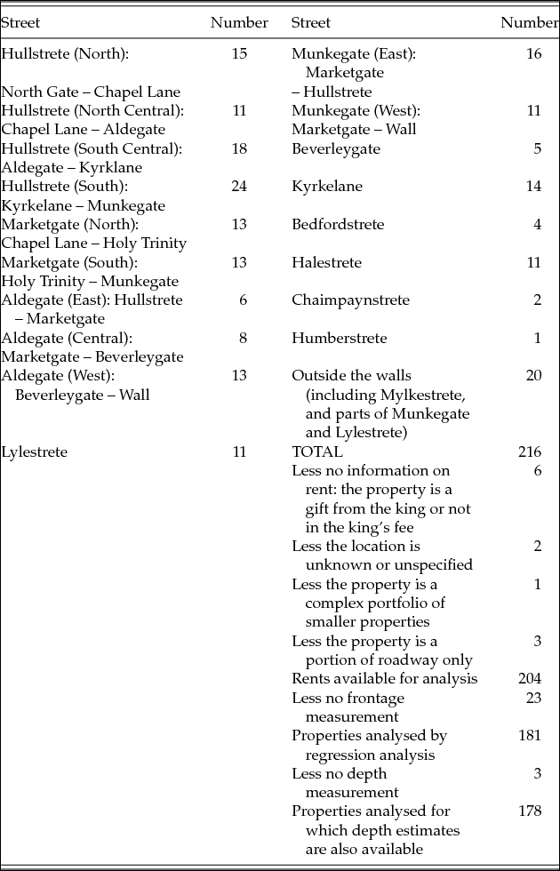
The distribution of properties by their street frontage is shown in Table 2. The number of properties backing onto each street was relatively small because many properties backed onto another property rather than another street. For the purposes of analysis, the longer streets were subdivided into sections. The four most important streets were Hullstrete and Marketgate, running north–south, and Munkegate and Aldegate running east–west (see Figure 1). Property frontages suggest a hierarchy amongst the streets. Hullstrete appears to have been more important than Marketgate as several properties in Hullstrete backed onto Marketgate, but no properties in Marketgate backed onto Hullstrete. Aldegate had few frontages to the east, where it crossed Hullstrete and Marketgate, but many frontages further west. This suggests that Aldegate was less important than Hullstrete or Marketgate. At the places where Munkegate crossed Hullstrete and Marketgate, the properties fronted onto the other streets, suggesting that Munkegate was less important too. Using the corner frontage criterion, Kyrkelane and Halestrete were side streets, but nevertheless both had a significant number of property frontages; those frontages were smaller than those on the main streets, however.
Distribution of properties by street with frontage

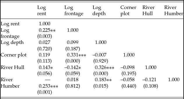
We can now begin to consider the potential causes of variation in rent levels. The relationship between rent, frontage and depth is examined in Table 3, using correlations. Statistically significant correlations are identified by asterisks, as explained in the note to the table. The results indicate that there was a statistically significant relationship between rent and frontage. This is then examined in more detail by considering the additional characteristics of a corner plot and a location on the river. The results suggest that corner plots tended to have larger frontages than other plots, but did not on average have significantly higher rents. Variations in the desirability of the respective rivers are apparent. Properties on the River Hull had smaller frontages and paid higher rents than average, whilst properties on the Humber paid lower rents. This suggests that the banks of the Hull were a more desirable area.
Zero-order correlations for selected variables

Notes: The results relate to the 178 plots for which rent, frontage and estimated depth are all available. Probability values are in brackets under the correlation coefficients. ***denotes 1% significance, **5% significance and *10% significance.
Influence of location, property frontage and depth and ownership on rent levels: hedonic regression
The use of regression analysis enables a more detailed investigation of those factors that cause variation in the level of rents. Hedonic regression is a well-established technique that has been applied both to modern property rents and to medieval and early modern agricultural rents.Footnote 60 The dependent variable in the regression is the logarithm of the rent and the independent variables are property characteristics. Some characteristics, such as size of plot, reflect economic factors determining rents, whilst others, such as the personal characteristics of the property-holder, represent social factors (for example social status). Factors such as location, the evidence suggests, reflect a combination of the two. The regression estimates the impact of each factor on rent whilst controlling for variations in all the other factors, for example it measures the impact of size whilst controlling for location, and the impact of location whilst controlling for size. The impact of each factor is measured by a separate coefficient. With a fixed stock of properties, such as those in the 1347 rental, each coefficient indicates the premium that a buyer would pay for the corresponding characteristic of the property. Impacts effect proportional changes in the rent, rather than absolute changes, i.e. they are bigger for valuable properties than for cheap ones.
The results are shown in Table 4. In regression 1, both frontage and depth are used as explanatory variables relating to property characteristics. The location of the property is measured by using the street onto which the property fronted.Footnote 61 Corner plots, proximity to rivers and relation to the town walls are other locational factors taken into account. An adjustment is applied for 10 nominal rents (labelled ‘feudal’). The identity of the owners is represented by dummy variables indicating whether a property-holder was a member of one of the five major family dynasties identified from the appendix.
Regression analysis of the logarithm of rent

Note: Probability values are in brackets under the correlation coefficients. *** denotes 1% significance, **5% significance and *10% significance. Missing measurements of distance lead to a multicollinearity problem that requires the omission of the ‘outside the wall’ dummy variable in regression 2; they also reduce the number of useable observations to 177.
The results of regression 1 demonstrate the importance of economic factors as a determinant of rent. Frontage has a positive and significant impact on rent: doubling the frontage increases rent by about 36 per cent. Frontage was more important than depth; depth carries a positive coefficient but it is not significant. This suggests that the social significance of frontage as an expression of social status may have been important too. A corner plot increased value by about 18 per cent. River frontage and relation to the walls were not important, but fronting on to the right street was crucial.
A centrality premium existed in Hull. Hullstrete demonstrates very high rents, with the effect being strongest in the south. Munkegate also had high rents to the east where it intersected Hullstrete. Aldegate East had high rents too, but only average rents in the centre or to the west. Lylestrete, Chaimpaynstrete and, in particular, Halestrete, had very low rents; they also were in the west of the town. This evidence points to the highest rents being around the intersection of two of the principal streets, Hullstrete and Munkegate in the south-east corner of the town just north of the confluence of the two rivers.
In contrast, the identity of the owner had little impact on the level of rent. The only significant finding is that the Lychefeld family paid somewhat lower rents than the average; Robert Lychefled was mayor at the time of the survey, but this does not seem to be the relevant factor. Lychefled held one of a small group of properties in Hullstrete that paid nominal rents and, in addition, held several larger properties to the west of the town where rents were in any case low. It is possible, therefore, that this result was due simply to the unusual nature of Lychefeld's property portfolio.
Perhaps the most impressive feature of this regression, however, is that over 75 per cent of the variation is explained by the factors mentioned above, as indicated by the R 2 statistic. Most of the explanation is attributable to frontage and street location, demonstrating that these factors had an important impact on levels of rent in medieval Hull.Footnote 62
Further analysis of central places
The results of regression 1 suggest the presence of a rental premium on central locations in medieval Hull. This is a feature that economists have noted in studies of property markets and therefore can be explored in more detail. Because of its emphasis on markets, economic theory suggests that the central place in Hull would be the marketplace adjacent to Holy Trinity church. However, regression 1 revealed that the properties with the highest rents were at a cross-roads between the market and the quay. To investigate this further, a second regression (Table 4 regression 2) has been estimated that includes, in addition, two distance measures.Footnote 63 One measures the distance of a property from the crossroads identified by the first regression and the other measures the distance from the marketplace (specifically the west door of Holy Trinity church). The results of regression 2 show clearly that rents declined with distance from the crossroads but did not decline significantly with distance from the market. This suggests that it was indeed the crossroads and not the marketplace that was the economic centre of the town.
Regression 2 contains further information. It shows that certain individual streets carried significant rental premia even when a distance measurement was introduced.Footnote 64 This suggests that those streets had distinctive characteristics other than distance from the centre that influenced their rent levels. Even more striking is the fact that different sections of the same street carried different rental premia, for example, different portions of each of the three major streets of Hullstete, Aldgate and Munkgate. The most obvious explanation is that each street had its own reputation that influenced local property rents and that this reputation reflected factors other than distance from the centre. The results do not indicate what these additional factors are, but they provide some clues.
Close examination of the coefficients on the individual streets in the second regression indicates that the impact of distance from the central place was asymmetric. Contrary to the assumptions of standard urban economic theory, rents decreased faster in some directions than in others. Specifically, rents declined more steeply to the west than to the north. To the north-west, the rents initially declined a little and then stabilized as the walls of De la Pole's manor were approached. This suggests that an additional factor influencing rents was the desirability of living either near the river or near to the manor house, and away from the area to the west of the market.
Finally, it appears that immediate neighbours mattered too. The residuals from the first regression can be used to measure spatial autocorrelation, a characteristic of property markets in modern towns.Footnote 65 Spatial autocorrelation measures the degree to which expensive properties are located next to other expensive properties, and cheap properties next to other cheap properties, after all other measureable factors (e.g. distance and street) are taken into account. The results of autocorrelation analysis are shown in Table 5. Neighbouring properties can be adjacent to each other in three main ways: at the front, at the rear (e.g. one backyard to another) or on a corner (where a property fronting one street adjoined a property fronting an intersecting street). The table shows that in Hull adjacency at the front was of greater economic significance than adjacency at the rear, although adjacency at the rear still affected rents. The final line of the table shows a positive but insignificant correlation for adjacency at a corner. These results suggest that the property market in Hull resembled a modern property market in its pattern of spatial autocorrelation. They also underline the importance of property frontage; it was not only the length of a frontage that influenced rents but the values of the properties to either side of it.
Spatial correlations

Note: *** denotes 1% significance, ** 5% significance and * 10% significance.
Discussion
The overall results suggest that most rents in Hull were set at commercial rates from the outset, most likely in the period 1299–1347. By the time of the 1347 rental, the distribution of rents reflected the spatial economy of the town. These factors, in turn, reflected the topography of a town that was a leading international port. The evidence points to a central place of high rents at the corner of Hullstrete and Munkegate. The fact that the market outside Holy Trinity church is not the central place suggests that an explanation of urban rents in terms of distance from the shops is not appropriate. In Hull, distance from place of business (on the staithes) appears to be at least as important, if not more so.
The results do not support the view expressed in urban economic theory that rents decline from the centre in a radially symmetric way.Footnote 66 They certainly declined from the centre, but this decline was moderated by other factors. Rents did not decline as quickly by moving north along the quayside as they did by moving south-east away from the quay. Some streets appear to have been more desirable to reside in than others, and one section of a street could even be more desirable than another section. Spatial autocorrelation, a feature often associated with modern property market, was also present in Hull.
Implications and conclusion
Both Hull's geographical location and royal investment appear to have contributed to making it a desirable location to live during the fourteenth century. Hull did not suffer the flooding that destroyed its nearest competitor Ravenserod, nor the silting that led to the decline of Hedon and many other ports.Footnote 67 Its topography was less constrained by natural barriers than, for example, that of medieval Shrewsbury and Durham which were bounded on three sides by a river.Footnote 68
The presence of a single dominant fee, that of the crown, enabled Hull to be developed systematically. This distinguished the topography of Hull from Coventry, for example, where dual lordship resulted in two urban focal points.Footnote 69 The absence of an urban religious institution following the withdrawal of the monks of Meaux Abbey distinguished Hull from many other medieval towns where monastic houses were local lords or property-owners. It is also notable that, despite religious houses investing in property in the eastern ports of Boston, there is little evidence of such investment in Hull.Footnote 70 This may have been due to the withdrawal of Meaux.
As a new town, Hull seems to have drawn its inhabitants from immigration from other towns. Careers in royal service and commerce provided livelihoods for the new settlers, and attracted emigration from other locations in a manner that suggests some parallels with Norwich in the same period. Research into the biographies of property-owners reveals evidence of the concentration of property-ownership in the hands of five families. This has similarities with patterns seen in York in the period 1086–1350, but there is little evidence in Hull to suggest that the identity of owners impacted on the level of rents. The five families may have been important for the number of properties they owned, but their members did not pay noticeably higher or lower rents than other individuals.
Although a new town, Hull's rents were not set at uniform levels. In this respect, it differed from other locations, including the eastern port of Grimsby.Footnote 71 The variation of rents in its property market is instead a characteristic that it shares with the river port of Gloucester in c. 1100 and c. 1455 and the new town of New Winchelsea in 1292.Footnote 72 Hull also shared with Gloucester the characteristic of spatial autocorrelation of rents in adjacent properties.
Similarities and differences in the location of central places are revealed when results from Hull are compared with those of other towns. In Gloucester, the central place in c. 1455 was the market, while in Hull it was at the corner of Hullstrete and Munkegate. Hull's central place shares greater similarity with that of New Winchelsea in 1292, where the most desirable properties were those between the harbour and the marketplace, and that of York in the twelfth and thirteenth centuries, where the corner of Stonegate and Petergate, at the approach to the Minster, had the most expensive properties.Footnote 73 Unlike the port of Sandwich, properties with the highest rents in Hull were situated between the rivers, rather than directly on either of them.Footnote 74 However, the presence of high rents in the north–south street of Hullstrete parallels the high rents found in the mid-thirteenth century in English Street, the main north–south artery in Southampton.Footnote 75
The qualitative and quantitative methodology developed for this article has the potential to be applied to other locations to supplement archaeological and geographical techniques. Results from Hull have highlighted potential differences between towns with uniform rents and towns with variable rents that would benefit from further comparative investigation. There are also indications of potential variation between towns in the location of central places of high rents, and in the identity of property-owners. Further research would benefit from additional comparisons of the spatial and geographical implications of the findings across and between long-established towns, such as Gloucester and Southampton, and newer foundations, such as Hull and New Winchelsea.
Supplementary material
To view supplementary material for this article, please visit https://doi.org/10.1017/S096392681800041X.