When we arrived at the great market place called Tlaltelolco, we were astounded at the number of people and the quantity of merchandise that it contained, and at the good order and control that was maintained, for we had never seen such a thing before. … Each kind of merchandise was kept by itself and had its fixed place marked out … and (there were) those who make the stone knives, and … split them off the stone itself (Diaz del Castillo Reference Diaz del Castillo1956:216–217).
The preceding epigraph is from Bernal Diaz's often quoted description of the Aztec marketplace of Tlatelolco, located in modern Mexico City. The marketplace was the center of economic life in the pre-Hispanic world and the place where staple goods, raw materials, and finished goods were bought and sold. The marketplace was where households provisioned themselves with basic resources and where the state converted tribute into alternative goods (Berdan Reference Berdan1982; Carrasco Reference Carrasco, Carrasco and Broda1978). Even though distribution was its primary function (Berdan Reference Berdan and Plattner1989), the marketplace was also an important center of craft production. It was where simple services such as barbering and tailoring were performed, and where artisans fabricated, customized, and sold finished goods in their market stalls. One of the more visible production activities in the marketplace was the production of obsidian prismatic blades. It is the often forgotten role of the marketplace as a point of manufacture that is examined here.
Interest in the role of the marketplace in Mesoamerican economy has increased in recent years (Blanton Reference Blanton, Berdan, Blanton, Boone, Hodge, Smith and Umberger1996; Garraty Reference Garraty2006; Minc Reference Minc2006). Despite this interest, archaeologists face the problem that market exchange is difficult to recognize. As a result, most archaeologists attempt to identify market activities in one of two ways; either by identifying marketplace locations from physical remains or from the way that market exchange affected the distribution of goods at the site and regional levels (Dahlin et al. Reference Dahlin, Jensen, Terry, Wright and Beach2007; Garraty Reference Garraty2009; Hirth Reference Hirth1998; Minc Reference Minc2006).
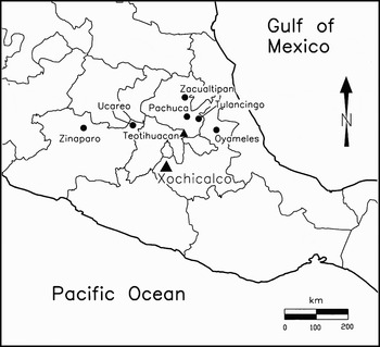
This article follows a slightly different line of inquiry and looks at the marketplace as a locus of craft production within society. It illustrates that evidence for the manufacture of obsidian tools can be an excellent indicator for the marketplace. The presentation is organized in several parts. First, it examines the archaeological approaches used to identify marketplaces in Mesoamerica along with the reasons why craft production should be included in these approaches. Next it discusses the site of Xochicalco, Mexico, and the evidence for market activity found here during the Epiclassic period (A.D. 650–900) (Figure 1). This is followed by a discussion of excavations that recovered in situ production debitage in an area believed to be the site's central marketplace. The article concludes with a discussion of the importance of craft activity as an aspect of pre-Hispanic market behavior.
The location of Xochicalco and major obsidian sources in central Mexico (adapted from Hirth et al. Reference Hirth, Bondar, Glascock, Vonarx, Daubenspeck and Hirth2006:Figure 5.2).

IDENTIFYING MARKETPLACES IN MESOAMERICA
When investigating pre-Hispanic market activity, archaeologists generally have followed one of three approaches: configurational, distributional, and contextual (Hirth Reference Hirth1998:453–454). The first two of these look for the physical remains of market activity, and the contextual approach relies on inferences drawn from indirect data such as the presence of large urban populations and full-time craft specialization believed to require marketplaces to exist (Hirth Reference Hirth1998). Because I am interested in the identification of marketplaces using physical remains, my discussion will focus specifically on the configurational and distributional approaches and how they apply to market research in Mesoamerica.
The configurational approach attempts to identify the location of the marketplace and its associated activities. It relies on identifying the archaeological correlates of marketplaces as we know them from ethnohistoric and ethnographic descriptions. Three types of information have been used in this approach: (1) large-scale architectural remains that define the location of the marketplace, (2) small-scale architecture associated with its internal organization, and (3) geochemical signatures produced by organic enrichments to the soil from market operations.
The use of architectural configurations recognizes that marketplaces were large assembly areas that were often convened in plazas that shared space with civic-ceremonial structures. As a result, archaeologists often point to large plazas as the loci for marketplaces. Because markets need to be accessible to the people that use them, they are often situated in centralized locations and/or linked to their surrounding regions by roads or causeways. Easy accessibility is a feature of the market and the presence of a road entering a large plaza often invokes the image of throngs of people gathering in a marketplace. Daily marketplaces are believed to have had more pronounced and permanent architectural features in comparison to periodic marketplaces (Hassig Reference Hassig1982, Reference Hassig1985). For example, descriptions of the daily marketplace at Tlatelolco (Cortés Reference Cortés1962:86–89; Díaz 1956:215–219) mention the existence of arcades and special buildings where judges resolved disputes.
Despite the imprecision of these indicators, archaeologists have used roads, plazas, and formal architectural arrangements to infer markets throughout Mesoamerica. Examples in the Mexican highlands where architectural remains have been used to identify marketplaces include Teotihuacan (Millon Reference Millon1973), Monte Alban (Blanton Reference Blanton1978:63; Winter and Payne Reference Winter and Payne1976), Xochicalco (Hirth Reference Hirth2000:186–188), Cholula (Wolf Reference Wolf1959:94), Cantona (Garcia Cook Reference García Cook2007), and Paquimé (Di Peso Reference Di Peso1974:2:400–402). In the Maya region, architecture has been used to infer the presence of marketplaces at Tikal (Jones Reference Jones1996:86–87), Chichen Itza (Ruppert Reference Ruppert1943), Caracol (Chase Reference Chase1998), Chunchucmil (Dahlin Reference Dahlin2003), Seibal (Smith Reference Smith1982:232), Sayil (Sabloff and Tourtellot Reference Sabloff and Tourtellot1991), and Coba (Folan et al. Reference Folan, Kintz and Fletcher1983). Although architectural characteristics are useful, they rarely stand on their own as conclusive indicators of marketplaces because plazas were multifunctional assembly areas where a range of social, religious, political, and economic activities took place.
A second indicator is the small-scale architectural features associated with the internal organization and operation of marketplaces. One of these indicators was the division of the marketplace into aisles, stalls, and corridors where sellers arranged their goods and buyers circulated to inspect them (Beals Reference Beals1975:123; Feldman Reference Feldman, Lee and Navarete1978; Warner Reference Warner, Cook and Disken1976:119; Wolf Reference Wolf1959:228). For example, linear features believed to be marketplace stalls have been identified in plazas at a number of Maya sites including Chunchucmil (Dahlin Reference Dahlin2003), Chichen Itza (Ruppert Reference Ruppert1943:Figure 45), and Sayil (Sabloff and Tourtellot Reference Sabloff and Tourtellot1991). Another important internal feature of the marketplace is the market shrine that can still be found in many contemporary markets throughout Mesoamerica. In this regard, recent excavations at Xochicalco uncovered a building on Platform P27-A that I believe functioned as a market shrine (Hirth Reference Hirth and Hirth2006b). These small-scale architectural features provide valuable supporting contextual data for identifying the use of large plazas as market areas.
The third type of information used in the configurational approach is geochemical enrichment to the soil. Marketplaces generate a large quantity of organic refuse that produces changes in pH and increases the phosphate content and other trace elements in soils. Chemical analysis of soils in the modern marketplace of Antigua, Guatemala, identified high phosphate and zinc concentrations in food service areas and where fruits and vegetables were sold (Dahlin et al. Reference Dahlin, Jensen, Terry, Wright and Beach2007). Analysis of soils in archaeological contexts, such as the large plaza at Chunchucmil, identified similar patterns around suspected market stalls (Dahlin et al. Reference Dahlin, Jensen, Terry, Wright and Beach2007).
The distributional approach seeks to identify market activity from the predicted material outcomes of market exchange and the distribution of products that it creates (Hirth Reference Hirth1998). The distributional approach is based on our understanding of the theory and operation of market exchange and how it affects the circulation of goods at the site and regional levels (Garraty Reference Garraty2006; Hirth Reference Hirth1998; Minc Reference Minc2006). Alternate forms of distribution shape the composition of household assemblages in different ways. Market exchange creates homogeneity in household material assemblages in proportion to domestic production, consumption, and individual purchasing power (Hirth Reference Hirth1998). These differences will also be reflected in the patterning of goods within regions (Renfrew Reference Renfrew, Sabloff and Lamberg-Karlovsky1975), and several archaeologists have recently attempted to measure market and nonmarket distribution at the regional level (Abbott Reference Abbott2006; Abbott et al. Reference Abbott, Stinson and Van Keuren2001; Garraty Reference Garraty2006, Reference Garraty2009; Minc Reference Minc2006). These developments are exciting because they offer a means of testing how markets affected the distribution of commodities throughout the regions that they served (Blanton Reference Blanton, Berdan, Blanton, Boone, Hodge, Smith and Umberger1996; Smith Reference Smith1979).
The discussion of craft production described here follows the tradition of the configurational approach by documenting an archaeological signature for craft production within the marketplace. It differs from most other studies in that it seeks to develop multiple lines of evidence for the marketplace as Dahlin et al. (Reference Dahlin, Jensen, Terry, Wright and Beach2007) have done for Chunchucmil. The burden of proof for the marketplace, therefore, does not rest on the evidence for craft production alone, but on its location in an area suspected of being a marketplace on other grounds. The question is: Should we expect to find evidence for craft activity in market settings?
CRAFT PRODUCTION IN THE MARKETPLACE
Contemporary Mesoamerican marketplaces primarily distribute agricultural products and finished manufactured goods (Beals Reference Beals1975). As a result, it is difficult to find examples of craft activity in marketplaces today. Many indigenous crafts have been eliminated through competition with industrial production and, where they still exist (see Mastache Flores and Morett Sánchez Reference Mastache Flores and Morett Sáchez1997), are practiced in domestic contexts and then transported to the marketplace as finished goods. However, this was not the case in pre-Hispanic times when the marketplace also was the location where some service trades and light manufacturing activities were carried out. Barbering, tailoring, and food preparation were common in marketplaces across Mesoamerica and it was where porters, prostitutes, and a range of other service personnel could be found. We know from ethnohistoric accounts that obsidian blades were produced in the marketplace and it is likely that other handicrafts were practiced there as well. The individuals who worked here would have been independent specialists who supported their families through full- or part-time craft activity in their homes.
Ethnographic, historic, and ethnohistoric research in Mexico has documented a range of service and craft production activities in large urban marketplaces during the Colonial period and early twentieth century (Cortés Reference Cortés1962:86–89; Díaz 1956:215–219; Diskin Reference Diskin, Cook and Diskin1976:55; Waterbury and Turkenik Reference Waterbury, Turkenik, Cook and Disken1976:212; Yoma Medina and Martos López Reference Yoma Medina and Martos López1990). In central Mexico, leather working was still common in the Cuautla and Cuernavaca marketplaces of Morelos during the 1960s and early 1970s. The Cuautla marketplace in particular was the center for the production and sale of an inexpensive white huarache (leather sandal) that was the regional rural footwear throughout central and eastern Morelos (Hirth Reference Hirth and Hirth2006b:339n2). Sandal manufacture in Cuautla took place in several market stalls with differing intensities depending on whether craftsmen also worked out of their homes. Production in the marketplace was important because it was here that raw materials were bought (e.g., leather, rubber for soles, metal fittings) at the same time that finished items were sold in retail and wholesale lots.
Despite the vanishing nature of market crafting, craft production can still be seen in marketplaces throughout the Mixteca, Mexico. Recent ethnographic research by Laura van Broekhoven (Reference van Broekhoven2007) has documented four different craft activities still practiced in multiple market settings. These include basket making in marketplaces at Tlaxiaco, Magdalena Peñasco, and Chalacatongo; petate or reed mat manufacture at Chalcatongo, huarache/sandal making in marketplaces in Teposcolula, Tlaxiaco, and Tilantongo; and finally, textile weaving within the marketplaces at Tlaxiaco, Chalacatongo, and Chicahuaxtla (Laura van Broekhoven, personal communication 2007). Another craft activity still regularly practiced in marketplaces today is the manufacture of flower wreathes used in commemorations at weddings, funerals, and school graduations. The perpetuation of this craft in the marketplace is a function of the perishability of flowers; wreathes are regularly made by flower vendors who simultaneously sell the cut flowers that they use in wreath manufacture.
Some of the best information on craft production from ethnohistoric accounts comes from the large central Mexican marketplaces of Tlatelolco, Coyoacan, and Tlaxcala. Documents from Coyoacan and Tlatelolco provide inventories of the items sold and the status of the vender who sold them (Anderson et al. Reference Anderson, Berdan and Lockhart1976:138–149). Vendors are identified in Nahuatl by the type of product sold and their commercial status is described in a suffix that distinguishes craftsmen and retailers from wholesalers. According to Rojas (Reference Rojas1995:230), the suffix -chiuhqui is used to refer to individuals who make their products, probably independent craftsmen.Footnote 1 By contrast, sellers with the suffix -namacac are individuals engaged in general retailing. A third category of sellers are the wholesale intermediaries who negotiate the price of the product for resale; these individuals are identified by the suffixes -necuilo (Carrasco Reference Carrasco, Carrasco and Broda1978:57–58; Rojas Reference Rojas1995:232) and/or -quixtiani (Feldman Reference Feldman, Lee and Navarete1978:220).
Information also is available about the type of vendors in the Coyoacan and Tlatelolco marketplaces. There are 26 craft specialists listed as selling products in the Tlatelolco marketplace, six to 10 of which include individuals who also may have practiced their craft in the marketplace (Feldman Reference Feldman, Lee and Navarete1978:Figures 35 and 36, Table 19; Rojas Reference Rojas1995:Table 15). Rojas (Reference Rojas1995:Table 15) lists 21 craft specialists who sold their goods in the Coyoacan marketplace, of which four to five may have worked there. Craftsmen who may have engaged in light craft production in the marketplace include fiber sandal makers, fiber cape makers, bag and sash makers, basket makers, reed mat makers, herbalists, and obsidian workers. The best documented of these are the obsidian craftsmen who several chroniclers (Diaz del Castillo Reference Diaz del Castillo1956; Sahagún Reference Sahagún1981:3:148) identify as making blades in the marketplace. Sahagún's description of the Tlatelolco marketplace (1981:3:148) is so detailed that it suggests that he observed the process of obsidian blade production firsthand (Clark Reference Clark, Gaxiola and Clark1989).
The regular mention of obsidian craftsmen make this craft a good candidate for detecting market-related craft activity. Particularly important in this regard is that obsidian craft production is readily identifiable in archaeological investigation. It generates production debitage that is durable, visible, and highly diagnostic of different types of manufacturing activities. Aoyama (Reference Aoyama1999:161) has identified obsidian production debitage in a production “dump” in the Great Plaza at Copan that could relate to craft production in a market area. The recovery of obsidian production within Xochicalco's suspected market area provided an intriguing opportunity to investigate whether craft production actually was practiced here.
XOCHICALCO AND ITS MARKET AREAS
The site of Xochicalco is located in the western valley of Morelos 70 km southwest of modern Mexico City. Xochicalco grew to prominence at the beginning of the Epiclassic period around A.D. 650. The site was a single period phenomenon. It was founded de novo as the new site capital of a regional confederation and remained a vibrant and important urban center until its abandonment around A.D. 850–900. Intensive mapping identified architecture and surface remains over a 4 km2 area. Population estimates based on house counts estimate the site population at between 10,000 and 15,000 persons at the height of its occupation (Hirth 2000).
Xochicalco rose to power during the Epiclassic period (A.D. 650–900). This was one of central Mexico's most tumultuous periods, characterized by conquest militarism and the rise of independent city-states in the wake of Teotihuacan's decline. Xochicalco was one of these independent city-states. Large-scale architectural construction and the numerous monuments and bas-relief carvings underscore the site's importance as a regional ceremonial center. Likewise, the identification of tribute glyphs on the Pyramid of the Plumed Serpent indicate that Xochicalco was the capital of a conquest empire that extended throughout western Morelos and into adjacent regions. Militarism was the foundation for Xochicalco's growth and rise to power as well as the reason for its demise. The site was dramatically destroyed and completely abandoned around A.D. 850–900 as a result of military conquest (Hirth 2000).
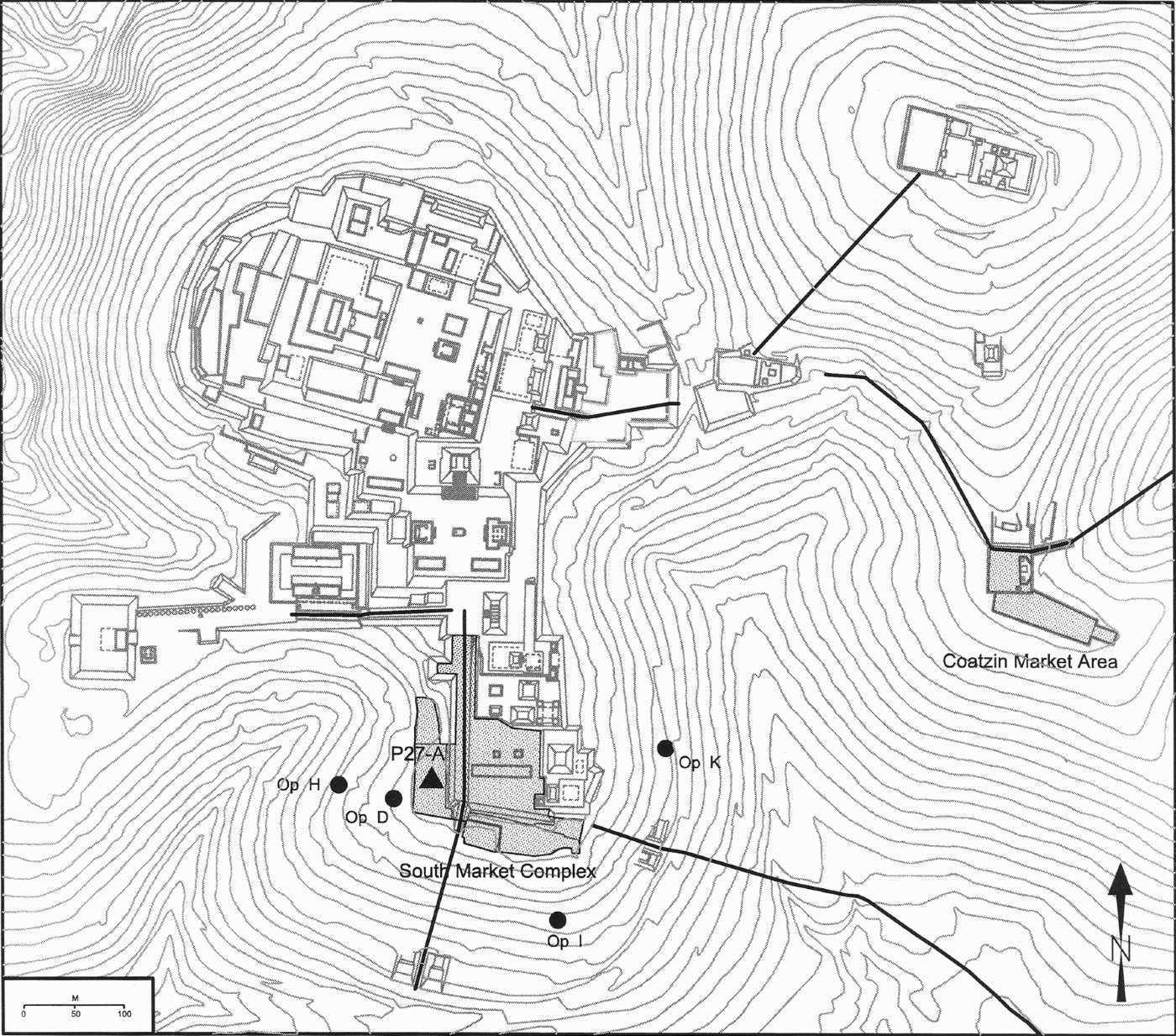
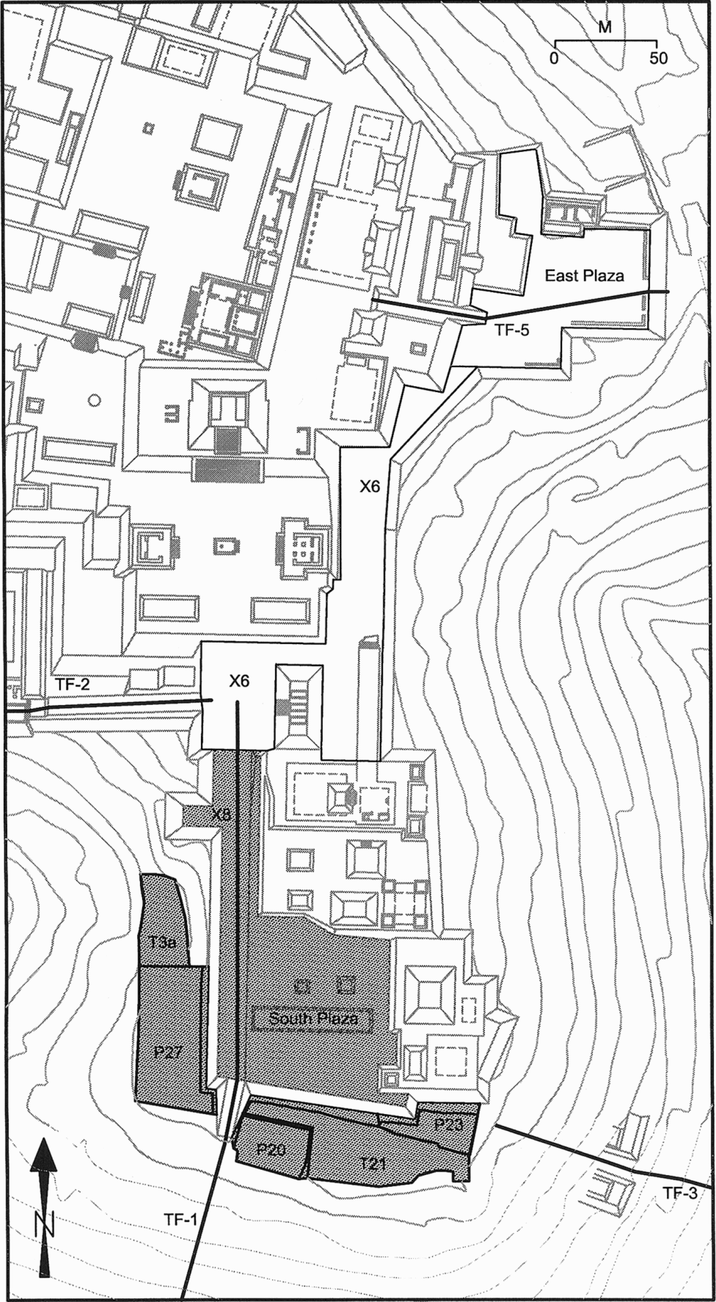
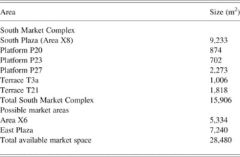
One important aspect of Xochicalco was the presence of a strong market economy. No archaeological site in Mesoamerica has more evidence for marketplaces than Xochicalco. Market activity has been identified here using both the configurational and distributional approaches. Two large plazas were identified as “possible” marketplaces during surface reconnaissance, one on the South Hill of Cerro Xochicalco and another on the southern slope of Cerro Coatzin (Figure 2). Both of these areas were connected by roads to the surrounding hinterlands and fit the profile of possible market plazas following the configurational approach (Hirth 2000). Moreover, it was at Xochicalco that the distributional approach was developed, and we see the effects of a central marketplace on the distribution of ceramic and lithic material in households across the site (Hirth Reference Hirth, Santley and Hirth1993, Reference Hirth1998). The larger of these two areas is the South Market Complex located on the South Hill of Cerro Xochicalco (Figure 3). Rather than a single plaza, this suspected market area is actually a complex of plazas, with the South Plaza (Area X8) at its center and several small platforms and terraces connected to it along its southern and southwestern sides (Platforms P20, P23; Platform Group P27; Terrace T21). Two main roads (TF-1, TF-3) provided good access into the South Market Complex from the surrounding region. Although none of the auxiliary platforms in this complex are large, together the South Market Complex covers 15,906 m2 of open space (Table 1). This is 29% of the plaza area of the Great Compound believed to be the central market area at Teotihuacan. If adjacent areas of Area X6 and the East Plaza also had market functions (see Figure 3), the available market space rises to 28,480 m2 (52% of the area of the Great Compound).
The location of obsidian workshops and two market areas at Xochicalco.
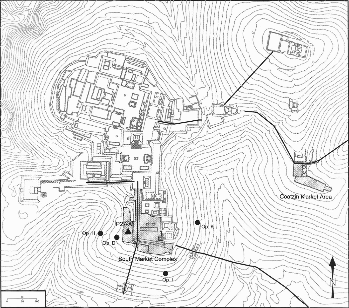
The South Market Complex and adjacent areas on Cerro Xochicalco.
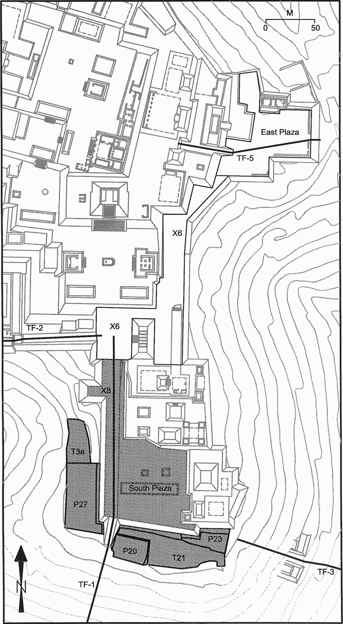
Size of the South Hill Market area at Xochicalco

The size of this area is best thought of in comparative terms as several ethnographic marketplaces in Oaxaca are actually quite a bit smaller than the Xochicalco marketplace. For example Warner (Reference Warner, Cook and Disken1976:121) reports that a secondary marketplace at Nochixtlan covers 3,440 m2, whereas a marketplace at Ayutla covers 2,700 m2 (Beals Reference Beals1973:123). The South Market Complex together with adjacent areas provides more than enough market space for a large periodic marketplace in an urban center the size of Xochicalco.Footnote 2 Furthermore, two small buildings were identified in this complex that may have had market functions: a low arcade building in the South Plaza and a possible market shrine on platform P27-A (Hirth Reference Hirth and Hirth2006b).
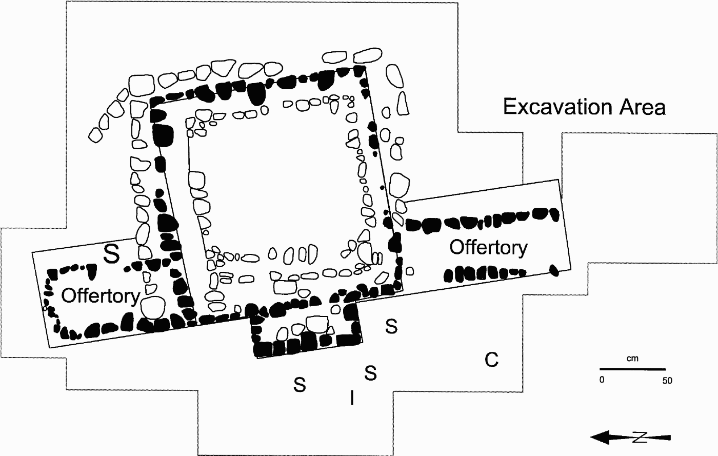
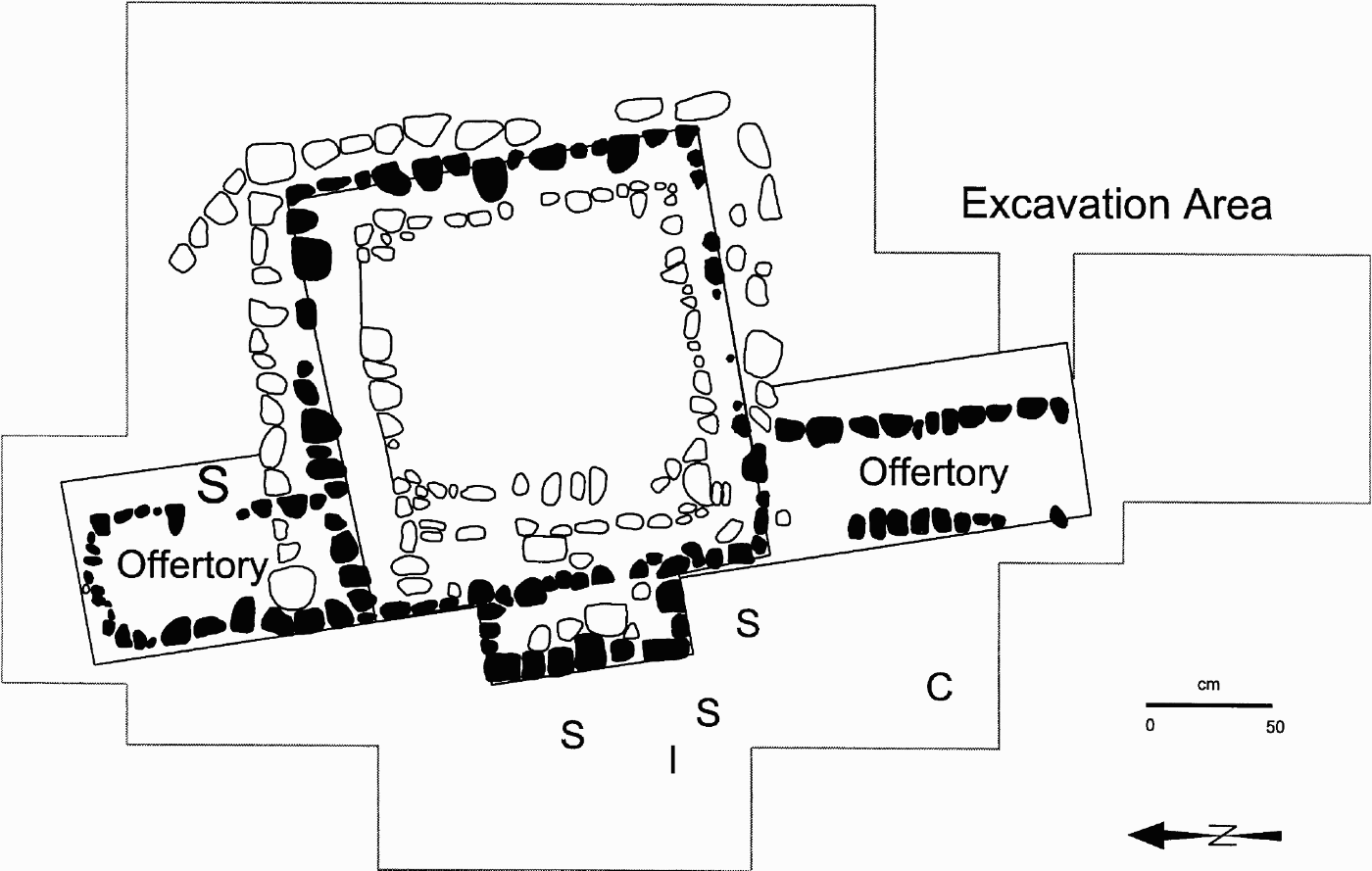
Platform P27-A is located within the South Market Complex below and alongside the southwest side of the South Plaza (Figures 2 and 3). Platform P27-A is one of three platforms in Platform Group 27, all of which lie within the South Market Complex. Platform P27-A was interesting because surface reconnaissance (Hirth 2000) suggested that it was built and maintained as an open plaza throughout the life of the site. Platform P27-A did not contain either an elite residence or a large civic-ceremonial building. Instead, the only structure identified here was P27-F5, a small shrine built in the shape of a miniature temple 3.5 m long (N-S), 3.55 m wide (E-W), and 80 cm high. A unique feature of this structure was the construction of two low lateral offertory platforms 30 cm in height on its north and south sides where offerings could be placed (Figure 4). The primary materials recovered from the excavation of this shrine were six large effigy ceramic sculptures: four in the form of marine shells, one in the form of an insect, and another in the form of a dog or coyote (Hirth and Webb Reference Hirth, Webb and Hirth2006).
Structure P27-F5 located on platform P27-A. S: Ceramic shell effigy; C: Ceramic coyote effigy; I: Ceramic insect effigy. Darkened stones show the original outline of the structure (adapted from Hirth and Webb Reference Hirth, Webb and Hirth2006:Figure 2.19).
Test excavations in 1992 identified possible in situ obsidian production debitage on the original plaza floor of platform P27-A (Hirth Reference Hirth1995). On the basis of this evidence, excavations were conducted in 1993 by the Xochicalco Lithics Project (Hirth and Webb Reference Hirth, Webb and Hirth2006) to (1) confirm the existence of in situ craft activity in this plaza, (2) determine the area over which production took place, and (3) identify the type of production activities carried out. Test units were placed across the plaza to follow the floor and to identify associated stratigraphy. In addition to following the plaza floor, excavations also identified the sequence of platform construction and the original preconstruction hillside surface on which P27-A was built. The plaza floor was intact and its associated material was largely undisturbed.
These excavations were designated as Operation G. Like other platform and terraces below the central ceremonial complex at Xochicalco, platform P27-A had a sandy earthen floor laid over a sand and gravel base. Bedrock was removed to level this area as part of the construction process and the plaza floor and floor preparation, which ranged from 10 to 20 cm thick, was laid directly over bedrock or a layer of sterile construction fill to shape the platform. Because the plaza had an earthen surface, materials used and broken on this platform were trampled into it creating a floor zone 5–14 cm thick. Along the eastern side of the plaza this surface was covered by 5–10 cm of sterile slope wash eroding off of the South Plaza (Figure 3). On the western side, this floor zone was more eroded and lay within the humus zone of level I. Test excavations along the west side also uncovered buried deposits on the hillside's original preconstruction surface.
The presence of an earthen floor across this plaza was fortuitous because a sample of the artifacts used and broken here were trampled into the floor zone that formed its surface. This included thousands of small ceramic sherds ranging from 1 to 4 cm in diameter, and tens of thousands of obsidian microdebitage fragments diagnostic of prismatic blade production. The ceramic materials were a mixture of Epiclassic period food service and cook wares, and not much analysis could be done because of their small size. The lithic materials, however, are highly diagnostic indicators of production activities and were concentrated in discrete activity areas across the plaza. They are interesting because they provide a palimpsest of production activities carried out in the plaza, and it is on these materials that this analysis is based. Like the ceramics, all these lithic materials were small because of the effects of trampling and the removal of large debitage through periodic cleaning. The average length of medial blade segments in these contexts is only 1.1 cm (SD = .41).Footnote 3
At the start of the excavations, we believed that platform P27-A could represent a market area for several reasons. First, it was a large open platform within the South Market Complex that I thought might have a special market function on the basis of its architectural design (Hirth 2000:Figure 9.1). Second, comparative analysis of domestic assemblages had already established the operation of market distribution within the site (Hirth Reference Hirth1998); the bigger issue was identifying where the marketplace(s) might have been located. Third, the presence of obsidian debitage from the manufacture of obsidian blades in a public plaza was reminiscent of the descriptions of market production found in ethnohistoric sources (Diaz del Castillo Reference Diaz del Castillo1956:215–219; Sahagún Reference Sahagún1981:3:148).
Alternative explanations for this production debitage were possible especially if craftsmen were involved in production as either attached specialists or as part of tequitl labor service (Hirth, Bondar, Glascock, Vonarx, Daubenspeck 2006). These alternatives were tested and rejected as possible explanations for the presence of production debitage in this setting.Footnote 4 Structure P27-F5 was the only building located in this plaza that was excavated to see if it was linked in some way to craft production as either a small workshop building or armory workshop. Excavation revealed that it was a small shrine that reinforced our impression that platform P27-A was part of a larger market complex.
The plaza surface of platform P27-A was excavated in 1 × 1 m units to control the spatial distribution of artifactual material (Figure 5). Slopewash overburden was removed where present and the plaza surface was excavated in 5–10 cm levels following natural stratigraphy. Two sampling strategies were used to recover artifactual remains. A macrodebitage sample was collected by sieving field deposits through .3175-cm screen mesh. This macrodebitage sample was used to plot artifact densities across the plaza floor and to identify obsidian production areas. The second sampling procedure collected unsieved bulk soil samples across the plaza floor. These samples were processed with standard water flotation with microdebitage and other small artifacts collected in the heavy fraction. The microdebitage sample was used to study specific production tasks across Platform P27-A.
Excavation units at Operation G and the location of structure P27-F5. Darkened stones show the original outline of the structure (Hirth and Webb Reference Hirth, Webb and Hirth2006:Figure 2.18).

CRAFT PRODUCTION IN THE MARKETPLACE
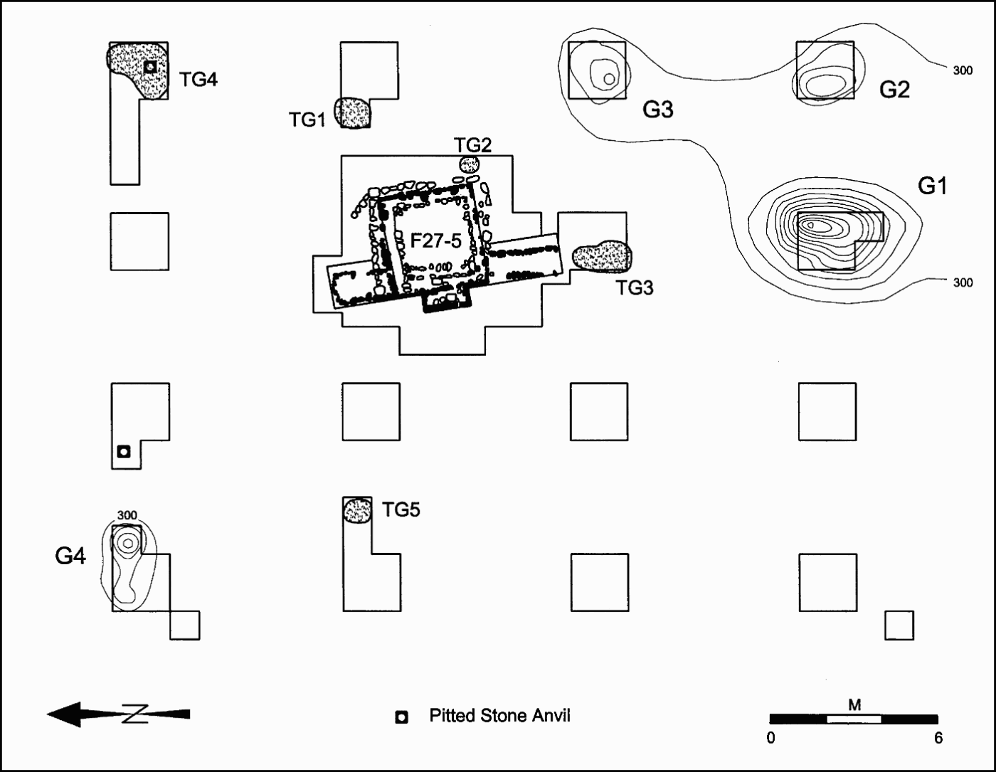
Nine obsidian production areas were identified on Platform P27-A from obsidian debitage embedded in the plaza floor (Figure 6). Four of these areas (G1–G4) were high concentrations of small debris representing areas where craftsmen worked over prolonged periods of time. Three of these work areas (G1–G3) were located at the plaza's southeast corner, and the fourth (G4) was situated at its northwest end. The remaining five areas were trace accumulations (TG1–TG5) representing small concentrations of material where production was lighter and less continuous. Four of these trace accumulations extend in an arc around the east and north sides of the small market shrine (Structure 27-F5) located near the center of the plaza.
Obsidian production concentrations on the plaza floor of Operation G (Platform P27-A). Contour intervals are 300 pieces of obsidian debitage (Hirth Reference Hirth and Hirth2006b:Figure 7.1).
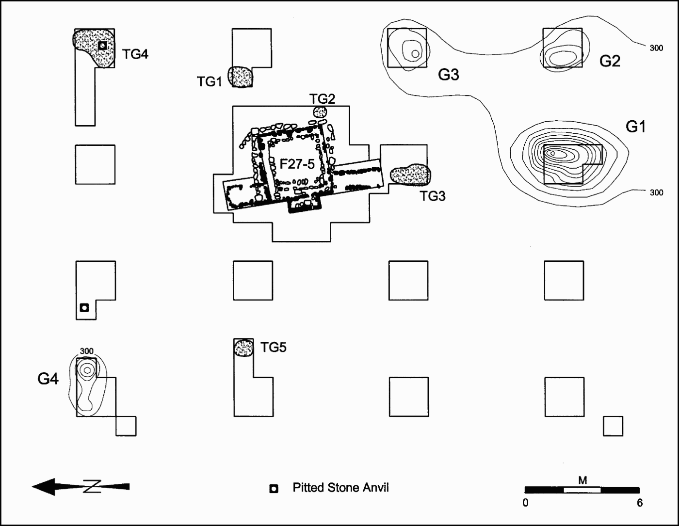
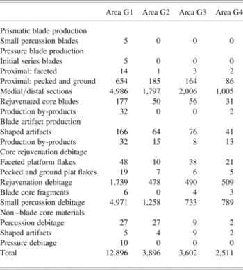
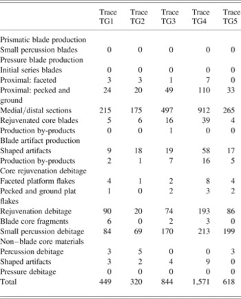
Tables 2–4 summarize the lithic material recovered in these nine production areas. All of these concentrations share two characteristics. First, the primary material worked was obsidian; some chert percussion debitage was recovered but in very low quantity. Second, all work areas show evidence for three production activities: (1) the rejuvenation of obsidian pressure cores, (2) the production of obsidian pressure blades, and (3) the production of tools from obsidian pressure blades. Despite good evidence for in situ craft production, only two small production tools (pitted stone anvils) were recovered from the plaza. This differs from domestic production areas where production tools are abundant. This difference is not surprising because craftsmen would have worked in the marketplace when it was convened and only would have brought portable tools that they could take with them at the end of the day.
Obsidian debitage in four production areas in Operation G

Note: Information taken from Hirth (Reference Hirth and Hirth2006b:Table 7.1), used with permission.
Obsidian debitage in trace production areas in Operation G

Note: Information from Hirth (Reference Hirth and Hirth2006b:Table 7.4), used with permission.
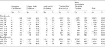
Obsidian blade-core production categories in at Operation G

Note: Information from Hirth (Reference Hirth and Hirth2006b:Table 7.3), used with permission.
Technological analyses reveal that craftsmen at Xochicalco received and worked pressure cores that needed rejuvenation before prismatic blades could to be removed (Hirth, Andrews, and Flenniken Reference Hirth, Andrews, Flenniken and Hirth2006). This rejuvenation made cores suitable for use using hand-held blade reduction strategy (Flenniken and Hirth Reference Flenniken, Hirth and Hirth2003). Core rejuvenation involved removing the core's faceted platform, shortening the core, and preparing a new pecked and ground platform closer to its midsection. These modifications made it possible to remove blades from pressure cores after they were too small for reduction using foot-held reduction techniques (Clark Reference Clark1982; Titmus and Clark Reference Titmus, Clark and Hirth2003).
Evidence for core rejuvenation is found in all nine production areas on the plaza floor. Core rejuvenation debitage and related small percussion debitage ranges from 26.9% to 52.9% of core-blade production activities recovered in plaza collections (Table 4). The two pitted stone anvils and the presence of small chert flakes mixed in with these materials indicates that some pecked platforms were prepared on rejuvenated cores by craftsmen working here. All production areas used already shaped pressure cores, although the recovery of five small percussion blades and five initial series pressure blades from area G1 indicate that craftsmen here also had access to at least one large polyhedral core.
Although pressure cores entered with faceted platforms, very few blades were removed from them prior to rejuvenation. The vast majority of blades (98%) came from rejuvenated cores with pecked and ground platforms (see Tables 2 and 3). The large, stationary grinding palettes used in finishing pecked and ground platforms (Hirth and Flenniken Reference Hirth, Flenniken and Hirth2006) were not recovered, which suggests that craftsmen brought ready-to-use cores with them to the marketplace.Footnote 5
The goal was not the production of complete prismatic blades, but the snapped blade segments produced from them. Producing blade segments required the removal of the proximal (platform) and distal (terminal) ends of blades. This led to the accumulation of small, unusable blade segments in production contexts. As indicated in Table 4, blade fragments range from 44.9% to 68.4% of the total obsidian production debitage in all nine areas. The medial blade fragments recovered here (x = 1.1 cm, SD = .41) were too small to use. These fragments were produced either as a by-product of creating snapped blade segments, when blade segments were worked into other tools, or when blade segments were adjusted to specific lengths requested by consumers.
One aspect of obsidian craft production at Xochicalco was the manufacture of tools from obsidian prismatic blades (Hirth, Andrews, and Flenniken Reference Hirth, Andrews, Flenniken and Hirth2006). These included stemmed and side notched projectile points, several types of eccentrics, and a variety of side notched, end notched, and pointed tools. These materials constitute 2% to 6% of all production debitage recovered in Operation G (Table 4) and account for 26% of all snapped blade segments produced calculated from the number of proximal sections recovered. The production and sale of small blade tools was a popular dimension of work in the marketplace.
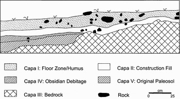
Excavations also identified the original paleosol and hillside surface on which platform P27-A was constructed. Bedrock studded the original hillside creating thin pockets of soil in the low areas between outcrops. Because the hillside sloped from east to west, portions of the original paleosol were only found along the lower western edge of the platform where they had been covered by construction fill. Hillside leveling along the central and eastern areas of the platform had removed both the original paleosol and large segments of bedrock to create a flat surface for the plaza floor. The identification of these deposits (Figure 7) and the recovery of cultural materials within the upper layer of this paleosol (levels IV and V) provide a glimpse into the activities that took place on the hillside prior to the construction of platform P27-A. What is particularly significant is that level IV represents a thin but dense concentration of obsidian debitage, once again from the production of prismatic blades. The nature of this context together with the size and type of materials within it indicate that these are in situ deposits rather than secondary materials deposited during platform construction.
Stratigraphic profile of the Suboperations G17 and G35 showing the stratigraphy of buried deposits along the west side of Operation G (Platform P27-A). Figure 8 provides the location of this profile (adapted from Hirth Reference Hirth and Hirth2006b:Figure 7.3).

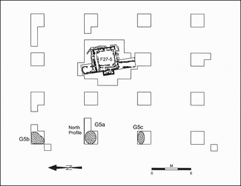
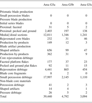
Obsidian debitage was recovered in paleosol deposits in three of the four areas excavated along the western edge of the platform. These concentrations are labeled as areas G5a, G5b, and G5c in Figure 8. Two aspects of these deposits underscore their identification as in situ deposits of production debitage. First, the artifactual materials recovered from areas G5a–G5c are almost pure obsidian debitage as would be expected from a specialized work area; the deposits have an occasional ceramic sherd mixed in, but as a whole range obsidian consists of between 99.6% and 99.9% of all materials recovered. Second, primary production locals of flaked stone tools will have high levels of microdebitage on the surfaces where tools were manufactured (Healan Reference Healan1995; Moholy-Nagy Reference Moholy-Nagy1990). The microdebitage samples from these three deposits confirmed their status as primary production loci. The macrodebitage sample for Area G5a consisted of 39,359 obsidian artifacts collected by sieving the soil matrix through .3715-cm screens. This represented only 30% of total obsidian in this deposit. The microdebitage sample of materials less than .3715 cm in size constituted fully 70% of the materials from area G5a, or an additional 91,800 pieces of obsidian confirming that these indeed were in situ production deposits.
The location of buried obsidian production deposits at Operation G (Platform P27-A) (Hirth Reference Hirth and Hirth2006b:Figure 7.2).

No attempt was made to follow the extent of these deposits although it is apparent that they follow the natural hillside underneath the western edge of the platform. Because excavations were limited, it could not be determined if they represented one continuous or three separate production areas. As a result, the area was labeled as production area G5 and the material from each test unit was described as samples G5a–G5c. This production debitage is summarized in Tables 4 and 5. How far they may have extended to the east is unclear because they would have been removed during bedrock leveling activities associated with the construction of platform P27-A.
Obsidian debitage in areas G5a, G5b, and G5c in Operation G

Note: Information from Hirth (Reference Hirth and Hirth2006b:Table 7.6), used with permission.
These production deposits are interesting for three reasons. First, they indicate that obsidian blades were produced in this area before the construction of platform P27-A. Second, the same prismatic blade production (33%–46%) and core rejuvenation (52%–64%) activities were carried out here as were recovered from later deposits on the plaza floor (Table 4). Blade tool production is also found in small amounts representing 2% of the production debitage. Like later deposits, there is no evidence for percussion core reduction indicating that the cores worked were prepared pressure cores with pecked and ground platforms. Third and finally, continuity in both the location and type of obsidian craft activities recovered from the pre- and postconstruction activity surfaces suggests continuity in the use of this area for the periodic production of obsidian tools from the beginning to the end of the Epiclassic period. The most parsimonious explanation for this continuity in production activities is that it took place within the context of a public marketplace.
DISCUSSION
Excavations on platform P27-A identified the original plaza floor, the fill materials associated with platform construction, and the original hillside underneath platform construction. Evidence for in situ obsidian craft production was identified on both the plaza floor and the hillslope predating the platforms construction. The excavation of structure P27-F5 on platform P27-A appears to be a small shrine that could have been associated with the operation of the marketplace at Xochicalco. I believe that the production residues recovered here were the result of obsidian craftsmen producing obsidian blades within the marketplace. Four characteristics of these deposits support this conclusion.
First and most importantly, craft production was associated directly with the plaza floor of platform P27-A. The plaza had an earthen floor that permitted the development of a floor zone where small ceramic and lithic debris were trampled directly into the active pedestrian surface, creating a palimpsest of production activities carried out over time. Without an earthen floor there would have been a much higher probability that all or most production debris would have been removed during post-market cleanup. Large public plazas often have stucco floors because of their civic-ceremonial functions rather than their suitability for market activities. Although stucco floors would be easier to sweep, earthen floors have several advantages for a marketplace; they absorb rainfall and other fluids spilled in the marketplace as well as provide a surface where posts can be anchored to support temporary awnings. If platform P27-A was a specialized market area, as I believe it was, then it may not have required stucco flooring if it was only used on market days. In fact many other large terraces and platforms below the upper ceremonial zone were constructed with earthen surfaces that were stuccoed (or not) depending on the function and types of the structures constructed on them.
Second, production activities were concentrated in a few areas of the plaza instead of being spread thinly over the entire area. Obsidian production debris is densely concentrated in the NW and SE corners of the plaza with trace accumulations in between (Figure 6). The buildup of debris in a few concentrated areas is important because it suggests a degree of regularity in where obsidian craftsmen practiced their craft within the marketplace. Craftsmen returned to the same places over time, which suggests that they worked in prescribed areas of the marketplace as reported in Contact period times. Although excavations were carried out on a grid, there was enough regularity in the spacing of production areas to create the “subjective impression” that the marketplace may have been laid out using aisles and rows as is reported for both modern (Beals Reference Beals1967; Cook and Diskin Reference Cook and Diskin1976; Malinowski and de la Fuente Reference Malinowski and de la Fuente1957; Smith Reference Smith1972, Reference Smith and Ortiz1983) and pre-Hispanic marketplaces (Cortés Reference Cortés1962:89; Díaz del Castillo 1956:215–219; Feldman Reference Feldman, Lee and Navarete1978). Although not confirmed by the excavations, it remains a possibility that should be explored in future investigations of suspected marketplaces.
Third, the size of the materials recovered conform to what is expected for a marketplace. Marketplaces typically produce a large quantity of trash that needs to be removed both for health reasons and so plazas can be used for other activities between market days. The archaeological implication of regular market cleaning is that large production debris should be regularly removed except for what was trampled into the earthen plaza floor. The same is true for production tools. Regular cleaning should remove most tools and, indeed, few were recovered. Even without regular cleaning, few tools would be found in a market plaza because craftsmen would only bring portable tools that they needed for the day.
The combination of trampling and market cleaning should result in the removal of all but small production debitage in market contexts. To test this proposition, debitage was compared with that recovered from domestic workshops, where production was more continuous and cleaning was selective and more sporadic. A sample of prismatic blade segments were measured for length and width and then compared with those recovered in each of the four domestic workshops at Xochicalco (Hirth Reference Hirth and Hirth2006a). Measurements indicated that blades fragments from the marketplace were on the whole noticeably smaller than those recovered from the four domestic workshops, a relationship that proved to be significant when evaluated using the analysis of variance statistic (F = 171.44, df = 1, p = .000).Footnote 6 The results support the conclusions that all but small lithic debitage was regularly removed from the plaza floor and that which remained apparently was not a hazard for people who visited the marketplace.
Fourth and finally, three buried production deposits were located on the hillside under the construction fill of platform P27-A. These deposits indicate that this area had a long history as a place where obsidian blades were produced. This area originally was a gently sloping hillslope and it is possible, even likely, that the South Hill was used as a market area well before the South Market Complex was constructed. After all, this is how marketplaces often grow, from informal gathering points to more formal usage areas. Unfortunately this proposition can never be tested because the majority of the original hillside on which platform P27-A was constructed was mined away as part of hillside leveling operations. The only place where this surface may remain is buried under construction fill used to create the South Plaza above and east of platform P27-A. That the South Market Complex may have been constructed to meet the needs of a preexisting marketplace is an intriguing possibility based on the presence of in situ production evidence buried under construction fill in the same area that later became the area where obsidian craftsmen worked in the marketplace.
Who worked in this market area? What type of craftsmen were they and where did they come from? Ethnohistoric sources indicate that most of the individuals who sold craft goods in the marketplace were producer-sellers. These were domestic craftsmen who worked a large percentage of their time in their homes and then came to the marketplace to sell their goods. This is implied in the terminology used to describe producer-sellers (-chiuhqui) and Rojas's (1995:Table 15) analysis indicates that fully one-half of the venders selling nonfood items in the Tlatelolco and Coyoacan marketplaces were craftsmen who worked in domestic contexts.
In economic terms, this means that the craftsmen working in the marketplace, including obsidian artisans, were specialists who worked independently of one other and controlled the means of production for their craft. Production among independent craft specialists was small in scale, domestic in focus, and conducted as part of the broader household subsistence strategy (Feinman Reference Feinman, Skibo and Feinman1999; Hirth Reference Hirth2007). Obsidian artisans sold their goods in the marketplace. Their success was based on individual skill, the size of consumer demand, and their general entrepreneurial abilities.
The evidence recovered across platform P27-A suggests that obsidian craftsmen worked in the marketplace at Xochicalco. Technological analysis indicates that most of the debitage recovered from P27-A was produced by Xochicalco's own domestic obsidian specialists, working in their homes as well as the marketplace. The same handheld production techniques and core rejuvenation strategies found in Xochicalco's domestic workshops were used to produced prismatic blades across P27-A (Hirth Reference Hirth and Hirth2006a). The primary obsidian worked across plaza production areas was from Ucareo, Michoacan, which was also the dominant source recovered from domestic workshops at Operations A and I (Figure 2). Largely missing from P27-A production areas are blades and artifacts manufactured from green Pachuca obsidian such as those produced in good quantities at Operations H and K. Green obsidian represents only 1.4% of the total obsidian assemblage at Operation G compared with 9.7% at Operation K and 25.1% at Operation H (Hirth, Bondar, Glascock, Vonarx, and Daubenspeck 2006:Table 5.5). This suggests either that not all of Xochicalco's domestic craftsmen worked in the marketplace, or more likely, that craftsmen from Operations H and K worked in another area of the marketplace.Footnote 7 Although it is likely that itinerant craftsmen also worked in the marketplace when they visited Xochicalco (Hirth, Bondar, Glascock, Vonarx, and Daubenspeck 2006), the available technological evidence suggests that most of the production debitage recovered this far was produced by local craftsmen.
Although excavations did not identify where all of Xochicalco's domestic craftsmen worked, we know that there were prohibitions against selling goods outside the marketplace in central Mexico at the time of the Conquest, both as a means to regulate exchange and to enable elite to collect their market tax. The recovery of production debitage on the paleosol beneath platform P27-A suggests long-term continuity in the use of this area as a marketplace. It also agrees in principle with reports that each kind of merchandise was sold in its own section of the marketplace (Cortés Reference Cortés1962:89; López de Gómara Reference López de Gómara1966:160). The frequency and regularity of production is another matter. The lithic concentrations identified on the plaza floor vary in size, and based on this, it is likely that only the larger work areas (G1–G4) are locales where local craftsmen worked on a regular basis. If this is true, then trace accumulations (TG1–TG5) could be residues produced by craftsmen who came to the marketplace on a less frequent basis.
CONCLUSIONS
Xochicalco has perhaps the best documented case for having a marketplace of any site in Mesoamerica for which only archaeological information is available. This article has explored the evidence for obsidian craft production in public plazas as a signature of marketplace activity. Ethnohistoric sources indicate that obsidian craftsmen were a regular feature of central Mexican marketplaces where they produced goods for sale. The location of platform P27-A within the South Market Complex and the evidence recovered from it are congruent with this interpretation. Excavations here uncovered a small religious structure (P27-F5) believed to be a market shrine and obsidian production debitage produced from in-market production activities. Multiple production loci within this plaza were identified from small concentrations of microdebitage trampled into the plaza's earthen floor. These concentrations were in situ deposits where cores were rejuvenated, prismatic blades were produced, and blade segments were modified into small blade tools. All of this took place within the South Market Complex, which I believe was a specialized market complex because of its architectural layout and the continuity in obsidian craft production in a public area both before and after platform P27-A was constructed.
Pre-Hispanic marketplaces were the basis of regional distribution networks throughout Mesoamerica. They were also the locations of limited, small-scale craft production. Obsidian craft production probably was a fixture of central Mexican marketplaces because prismatic blades were a basic commodity used by all households as well as many craftsmen in central Mexico. In many small marketplaces, obsidian blades were probably supplied by itinerant craftsmen who produced goods on demand within the marketplace. In large centers such as Xochicalco, blades and other goods were produced by local craftsmen who manufactured and modified blades to meet the needs of their consumers. This made obsidian production an important component of the marketplace, a practice followed by other craftsmen where it was possible to do so.
The marketplace was an important economic and social institution in the lives of pre-Hispanic Mesoamerican peoples. Developing signatures for market behavior, therefore, is an important task for archaeologists to pursue. This research suggests that obsidian craft production occurred in the marketplace and can be identified when debitage is recovered from primary contexts that conform to the expectations of marketplace behavior and postmarket refuse removal. For this reason, craft production can be added to the configurational approach as a means of identifying market activity. It is hoped that an awareness of the marketplace as a locus of both production and distribution will facilitate the identification of marketplaces at other sites in Mesoamerica where they occurred.
RESUMEN
El mercado fue una institución importante para el abastecimiento del grupo doméstico y la conversión de recursos por parte de la élite en la Mesoamérica prehispánica. A pesar de su importancia, los mercados son difíciles de identificar debido a que las relaciones de intercambio son por lo general invisibles en el registro arqueológico. Este estudio examina la evidencia sobre la existencia de un importante y activo tianquiz en el sitio de Xochicalco, Morelos, México durante el período Epiclásico. Xochicalco ostenta la mayor evidencia arqueológica que apoya la existencia de un mercado prehispánico en relación con cualquier otro sitio de Mesoamérica. Tres tipos de información recopilada en la última década apoyan la existencia de un tianquiz en Xochicalco. Esta incluye: 1) la información arquitectónica sobre la planeación del sitio que identifica la ubicación de posibles tianquiz dentro del sitio, 2) información sobre los efectos distributivos derivados del abastecimiento del grupo doméstico a través del intercambio en el mercado y cómo esto afecta la composición de la colección de artefactos domésticos, y 3) evidencia arqueológica de producción artesanal dentro del tianquiz que se ajusta a las descripciones etnohistóricas de los primeros conquistadores españoles.
Este trabajo presenta información sobre los aspectos arquitectónicos y de producción artesanal de la actividad del mercado en Xochicalco. Su enfoque primordial es sobre el papel de la producción artesanal en el tianquiz como un posible indicador de actividad del mercado. Mientras que investigaciones recientes han intentado identificar al mercado utilizando información diversa, el alcance del tianquiz como un centro de actividad artesanal periódica o temporal ha sido considerablemente ignorada. Las excavaciones en un área de Xochicalco donde se sospecha que existía un mercado, la cual será referida como el Complejo del Mercado Sur, localizado en la loma sur del Cerro Xochicalco, mostraron evidencia de producción in situ de navajillas prismáticas de obsidiana sobre el piso de una plaza pública. Estas exploraciones fueron hechas como parte del proyecto Xochicalco Lítica y proveen parte de la primera información sobre cómo pudo detectarse un mercado del Centro de México en términos de indicadores arqueológicos. Un elemento diagnóstico importante del área de mercado fue un pequeño templo adoratorio con bancas o altares laterales bajos que pudo ser utilizado para recolectar o exhibir ofrendas rituales dentro del mercado. Excavaciones de prueba a lo largo de la orilla oeste de la plaza del tianquiz llevaron al descubrimiento inesperado de evidencia más temprana sobre artesanía depositada in situ en la ladera natural por debajo y antes que la plataforma del tianquiz fuese construida. Esto sugiere que el Complejo del Mercado Sur pudo haber sido construido para satisfacer las necesidades de un mercado preexistente que operaba sobre las laderas del Cerro Xochicalco cuando el sitio creció en tamaño al inicio del período Epiclásico.
La presentación está organizada en varias partes. Primero, se examinan los enfoques arqueológicos utilizados para identificar un los mercados en Mesoamérica junto con las razones por las que la producción artesanal debería ser incluida en dichos enfoques. Después se discute el sitio de Xochicalco, México y la evidencia sobre actividad de mercado encontrada en él para el Epiclásico (AD 650-900) (Figura 1). A esto le sigue una discusión de las excavaciones que han recuperado desechos de producción in situ en un área considerada como el mercado central del sitio. Los resultados de estas exploraciones son discutidas en términos de lo que contribuyen al mejor entendimiento de la estructura de la economía prehispánica y se concluye que la producción artesanal puede ser un indicador útil de la actividad de mercado si se encuentran desechos de producción en contextos primarios en plazas públicas.