Spatial approaches to urban history are enabling new interpretations of pre-modern cities ranging from the dynamics of micro-scale local communities to the borders and liminalities of jurisdictions.Footnote 1 Many new approaches to these records are conceptually spatial, but digital Geographical Information System (GIS) approaches to analysis allow for particularly exciting and innovative reinterpretations of these records. Reinterpreting the history of major late medieval and early modern cities necessarily involves reinterpreting sources that have been known to generations of scholars, such as civic registers, guild records, property deeds and personal wills. This is especially true in terms of spatial patterns within the ‘shallow’ prosopographical records of everyday lives that make up the bulk of these most numerous classes of medieval and early modern urban records. Charting individual relationships amongst these shallow records enables a shift of focus from the civic elites, for whom there are deeper records, to encompass significant swathes of the middling citizens of a city like London.
This article reflects upon the methodologies involved in mapping these social relationships, focusing upon a case-study of the social relationships implied through selections of witnesses, executors and supervisors in late medieval London wills and property deeds. Most of the examples discussed here are drawn from a project exploring the social world of one neighbourhood of the City of London during the late medieval period (c. 1380–1520) using the copious, but far from uniform, registers of deeds and wills in the city's records.Footnote 2 The relative value of spatial interpretation based upon parish of residence in GIS is compared with more precise analysis by individual dwelling. Most significantly, geographical analysis and comparisons are made on the same basis as other social categories, as part of a broader social and economic analysis of the social character of the city's neighbourhoods. By looking into the social relationships of individual late medieval Londoners through a spatial lens, new insights into the operation of social networks and sociability in the pre-modern city become possible. While the examples here are drawn from the particular contexts and sources of late medieval London, they illustrate the challenges and approaches that are much more broadly applicable. The possibilities of navigating and analysing voluminous records of urban lives, as well as the complications posed by imprecise and ambiguous geographical descriptions, are common to a wide range of historical contexts.
The article also considers the relative merits of different ways of depicting and interpreting ‘precise’ maps created from GIS analysis of inherently ‘fuzzy’ pre-modern data. The use of GIS to analyse early modern historical records raises many issues which stem from the fundamental tension between the implied precision of the geographical data model of GIS, and the imprecision and inconsistency inherent in pre-modern spatial description. The GIS software that is currently available embodies a positivist geographical epistemology, based upon the concrete structure of Cartesian co-ordinates and fixed observations. This creates a tension with both the nature of historical data created in earlier spatial paradigms, and with the more qualitative priorities of many historians, both of which must be carefully navigated. This question of data quality in historical GIS has often been raised, but solutions, such as technical implementations of ‘fuzzy co-ordinates’, have not gained widespread application.Footnote 3 Alexi Baker has discussed the application of what she called ‘vernacular GIS’, based upon a manual, visual, process of mapping points onto georeferenced historical maps, using the same visual cues and pointers that were employed in the original early modern description of a location.Footnote 4 This article develops these ideas as part of alternative approaches to rendering pre-modern spatial description into GIS environments. These processes can be labour intensive, and are self-consciously subjective, but revolve around the principle of, so far as is possible, maintaining a sympathy and understanding of the spatial understanding of urban space that informed their original creation.
Spatial description in the late medieval city
The topographical features of late medieval cities can be recovered and mapped to a remarkably thorough and useful extent by using the established methods of map regression and morphological analysis, as the International Historic Towns Atlas project has exemplified repeatedly over the years.Footnote 5 However, mapping not only topographical features but social and cultural uses of those spaces pose particular challenges, especially in a late medieval city. While mapping social and economic data within a nineteenth-century city poses the challenge of geocoding street names and house numbering that may have since changed, the late medieval and early modern city had a diversity and inconsistency of spatial description that is an especial challenge for geographical analysis.Footnote 6 Nonetheless, numerous social and economic sources for the urban history of this period are inherently spatial, and with appropriate analysis reveal intriguing patterns of sociability and spatial clustering. Crucially, the potential to consider location as a category of analysis alongside traditional urban affiliations such as guild membership, and categories of wealth, is one which can justify the difficulty involved in translating the data into geographical form.
Street numbering was not widely used before the eighteenth century; instead, a bewildering range of different forms of geographical description were employed.Footnote 7 Descriptions of locations within cities were given in different forms in different contexts. When discussing an individual, their location of residence was almost never given as a precise address, but more often simply a street or a parish of residence. Individual properties and buildings tended to be described with more precision using visual symbols or signs, in the manner of modern pubs.Footnote 8 However, this naming and visual description of properties was far from universal. Amongst over 150 properties identified from property deeds in the four fifteenth-century London parishes in my own research, only 17 were described with a name.Footnote 9 While all taverns and inns, and most alehouses, were described with a name, more of the named properties were simply houses or shops.
In documents such as deeds properties were almost always described in terms of their abutting properties. Spatial descriptions generally started with the name of the street or lane which the property faced, followed by details of the ownership and nature of properties on adjoining plots. It is certainly possible that the other properties might also have possessed symbolic names at the time; it could have been regarded that the abutment information was sufficient for legal purposes, and hence the names were not recorded. The approach of interpreting these abutments to join together records of property transactions in the medieval city was taken to its fullest conclusions to create full property histories by Derek Keene and Vanessa Harding's ‘Cheapside Project’ in the 1980s.Footnote 10 Similar approaches have been used in other cities, more recently with the application of GIS. Tim Bisschops’ study of fifteenth-century Antwerp employed detailed records of property transactions which were compulsorily enrolled in the registers of the city's Court of Aldermen. This gave him a much fuller picture than has been possible in London, where property deeds were voluntarily enrolled in the London Court of Husting and rarely contained dimensions of plots and frontages.Footnote 11
The tension between this pre-modern source data, which is schematic and relative in its spatial description, and the topographical precision of GIS is highlighted by the inherent difficulty of translating these vernacular descriptions of space into precise locations. Definitive precision on the dimensions of any one plot, and therefore its location relative to other plots which had been described in relation to each other, is only realistically possible by following the entire history of that property to a point where both it, and all of its neighbours, had been measured accurately. Only a minority of plots were measured out in late medieval London deeds, while some entered the hands of an institution which conducted surveys of their lands, but the dimensions of most were only documented in the aftermath of the Great Fire, when many property boundaries were adjusted or disputed.
Even though the kind of spatial information contained in these late medieval property descriptions is in one sense very precise, as they contain very detailed descriptions of spatial relationships, it is very difficult to render this information into GIS compatible co-ordinates. The ‘vernacular’ description of these properties was essentially topological, rather than topographical, in its nature: spatial entities were described in relation to each other rather than in Cartesian terms. The traditional way of identifying historical property boundaries, which might be possible to match with the descriptions in the deeds, relies on the process of map regression: inferring topographical detail from progressively earlier maps. This is well documented but relies upon continuity of key features such as street patterns.Footnote 12 The earliest topographically accurate map of London which depicts property boundaries dates from the immediate post-Great Fire period: that of Ogilby and Morgan from 1676. Given that the property boundaries of the immediate pre-fire period were more often than not replicated post-fire, it is reasonably plausible to equate the descriptions in earlier deeds with the topographical outlines shown on this map. Exceptions to this continuity include the widening of many roads, and individual changes to boundaries which were documented in the records of the Fire Court. The regularity of the plots on Ogilby's map appear to represent regular subdivisions of conventional burgage plots, but could equally well suggest that they are relatively schematic or simply representative rather than having all been accurately surveyed.
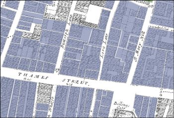
Comparison between the conjectural reconstruction of late fifteenth-century boundaries based upon the textual evidence from deeds, and Ogilby and Morgan's map (Figure 1) shows that the relationship between them is at best approximate. Many more plots, or subdivisions of plots, can be seen on the map than could be located within the earlier deeds. Whether this is because the chronological gap between the sources is too great, or because of a deficiency in either of the sources, can only remain an open question. In the example of the sample of London parishes clustered around London Bridge, it was found that many of the properties away from the busiest (and most valuable) thoroughfares only entered the documentary record of the Husting Court once or twice in the period c. 1380–1520. While, in most cases, it was possible to establish schematic frontages of properties and their ownership, in some cases, uncertainly remained as to whether descriptions of a property at extremes of the sample period were in fact the same tenement, or whether, for example, one or two tenements occupied a given space. While the schematic level of precision derived in this way might feel insufficient, it is nonetheless consistent with contemporary vernacular understanding of those spaces.
Comparison of property boundaries shown on Ogilby and Morgan's 1676 map of London and conjectural late medieval reconstruction based upon evidence in deeds

Spatial description of people
While properties and locations within the late medieval City of London were described in inconsistent terms, individuals tended to be described, at least in legal documents, in a more consistent manner. The 1413 Statute of Additions decreed that for writs to be valid, individuals should be named together with their ‘estate, degree or mystery’ and with their location of residence.Footnote 13 This formula was routinely carried over from its origins in writs to become the conventional way for individuals to describe themselves (or for their scriveners to describe them) in almost all late medieval English documents. In larger towns and cities, especially London, the parish was the default unit of spatial description for individuals. With, famously, over 100 parish churches within the one square mile of the City of London, this formula allows for remarkably precise identification of most individuals in late medieval London. While many Londoners shared the same fore and surnames, the routine addition of their ‘mystery’, conventionally given as their guild affiliation, and parish of residence, allows the majority of references to individuals to be identified both socially and geographically.Footnote 14 London's extreme density of parishes, and hence spatial description, is mirrored, to some extent, in other large English medieval cities, such as Norwich. However, in most cases, the use of the parish as a unit of spatial description introduces a social bias, as poorer suburban parishes tended to cover an exponentially larger area. Particularly as population grew in the sixteenth and seventeenth centuries, a geographical description of ‘St Sepulchre’, one of London's largest extra-mural western parishes, became of little use in identifying an individual in any respect. Therefore, there was some tendency to give more detail such as a street name, but this was far from being typical, even at the close of the sixteenth century. Inevitably, this is also a highly gendered system of description: rather than having been described by occupation or mystery, women were almost always described by their marital status, making it much more difficult to reconstruct their social or geographical context from a single reference.Footnote 15
While it may be possible to locate individuals more precisely through details of their property ownership, the complexities of the metropolitan property market can actually make that a very problematic measure of the relationship between individuals and locations. In late medieval London, property was generally held in the form of tenement plots which would contain either a conventional urban layout of a domestic range and yard located behind a shop, or a much more elaborate and denser range of buildings.Footnote 16 Furthermore, landownership in fifteenth-century London was highly concentrated amongst a small number of rich merchants, typically members of the greater guilds, and indeed in the hands of institutions such as churches and the guilds themselves. The social range of landownership was even narrower than the already restricted social range of those documented through the other key personal record of late medieval people: the making of wills. Most Londoners therefore rented their accommodation and are thus invisible from the property record. This, together with the widespread use of legal devices such as enfeoffement to use, meant that property ownership was no indication of residence. The only definitive indications of occupation tended to appear in descriptions of abutments of neighbouring properties, where a property was occasionally described as being ‘of’ one owner, but ‘presently occupied by’ another person. Rental registers kept by ecclesiastical or civic institutions offer an excellent opportunity to investigate occupation and uses of properties, but most institutional portfolios were widely distributed throughout the city rather than having been consolidated in coherent locations. London Bridge offers a notable and significant exception, where rentals show the tenants changing year to year on what was effectively a complete street.Footnote 17
Therefore, despite the potential riches of more detailed spatial sources, the unit of the parish offers the most suitable, inclusive and most importantly consistent level of spatial description for understanding the social landscape of the late medieval city. The methods and questions that can be applied to these sources which described locations and individuals at such different levels of precision must be framed in a manner that is consistent with their original uses. Relatively precise, although schematic, locations of properties can be used to ask specific questions of property ownership, while broader social questions can only be explored spatially through the application of higher-level units of description.
Geocoding vernacular locations
Attempting to map late medieval or early modern urban history using parish level ‘address’ data allows for relatively simple geocoding processes to attach our data to co-ordinates derived from a map of those parishes, or by attaching them to the polygon shape outlines of the parishes themselves. However, this reminds us of the fundamental tension between the implied precision of GIS and the imprecision of the data. If we locate a record of an individual using a point, we are implying the precision of that point, which was almost certainly not the residence of that person. Conversely, if we attach a record of an individual to a polygon shape representing a parish, which could be very large, that creates an implied relationship between that person and the entire area covered by that polygon, most of which they may have had no relationship with at all. Technical solutions to the challenge of recording the ‘fuzziness’ of data within the constraints of structured co-ordinate systems tend to focus upon providing buffers to represent uncertainty visually.Footnote 18 However, by choosing to map data at a consistent, if imprecise, unit of spatial reference (like parish), medieval data can be displayed in a way which can convey this imprecision through its generalization. Reducing the precision of all data to the lowest common denominator of parish and generalizing at that level, it can be geocoded in a consistent way which makes the lack of specific precision instinctively visible in a simple way. Coding many individuals or events to a single co-ordinate raises the issue of displaying the results effectively, as they will be effectively stacked upon each other, and therefore invisible. In recent years, more flexible methods to display this kind of data, such as offset points and heat maps, which offer more flexibility than the ‘Collect Events’ tool in ArcGIS Desktop, or table joins based on summary spreadsheets, have become easier to create using software such as QGIS, ArcGIS Online and ArcGIS Pro.
What can spatial analysis of medieval urban data reveal?
The sources which were reinterpreted in the project discussed here – deeds and wills – enable a wide range of insights into local sociability. While property ownership as recorded in deeds has been shown to be perhaps of less interest than might initially be supposed, other questions can be explored from the combinations of individuals party to each of the documents. Both classes of documents were routinely formally witnessed by anywhere between two and twelve individuals. Witnessing was the primary method of verifying documents in the pre-modern world, but it also played a wider social role in cementing local relationships. Acting as a witness was, in the words of Craig Muldrew, ‘a casual, and normal, part of daily activity, and was one of the duties of neighbourliness’. It created an oral as well as written record of a transaction, ensuring that the ‘memory of transactions was woven into the fabric of the community, as much as they were written into diaries or private account books’.Footnote 19 The choice of witnesses to both deeds and wills can therefore reveal much about the social networks of the city.
Deeds, and especially those enrolled into the rolls of London's Court of Husting, were designed to establish publicly the legitimacy of transactions in real property. No fewer than 377 deeds of gift, purchase, lease or feoffment survive from the sampled parishes between 1400 and 1500; of these, 183 carry a witness list, revealing a total of 1,135 instances of individuals acting as witnesses.Footnote 20 The average number of witnesses to each deed was six, although most had either five or seven, and the realistic minimum number was three. Three ‘enfeoffment to use’ transactions, which conveyed lands belonging to John Reynewell, fishmonger and alderman, in four parishes across the city including St Botolph Billingsgate and St Mary at Hill, had as many as 15 witnesses. Yet, startlingly, although witnesses are named 1,135 times in the 183 documents, only 365 unique individuals appeared. The same few individuals repeatedly acted as witnesses to each other's transactions, suggesting the reciprocal arrangements found by Muldrew in the seventeenth century.
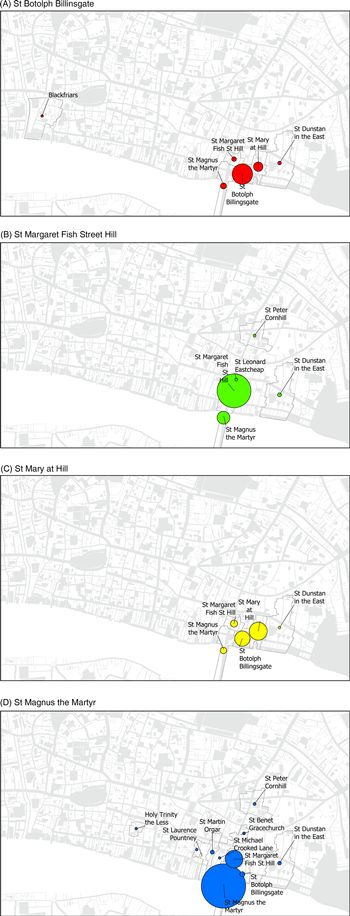
All of the parties to each deed were recorded as separate individuals within a relational database, and their parish of residence recorded from a predefined list. This enabled easy matching to a gazetteer of point co-ordinates generated as the centre points (centroids) of the parish boundary polygons on the map. Each transaction can therefore be analysed both socially, within the database or using Social Network Analysis software, and spatially, within the GIS. While the majority of witnesses were resident in the same parish that the property being conveyed was located in, there was a distinct geographical pattern to the residence of the others (Figure 2). After the parish in which the property was located, neighbouring parishes were always those home to the most witnesses. Smaller neighbouring parishes, or parishes that were nearby but not contiguous, were occasionally home to witnesses, but witnesses from distant parishes were distinctly rare.
(A, B, C, D). Size of circles is proportionate to the number of witnesses to deeds resident in each labelled parish

Looking in more detail at the witnessing of deeds relating to the parish of St Margaret Bridge Street reveals that witnesses were drawn from a more complex geographical network than simply the parish and its neighbours. Looking at individual relationships between parties to deeds and their witnesses in the form of a social network graph reveals even more intricate spatial relationships. Parishioners of St Margaret were the most frequent witnesses to deeds relating to property in that parish: they form the core of the network (Figure 3). Witnesses who cannot be identified, or who resided in the neighbouring parish of St Magnus, appear on the margins of the network, indicating that they were not involved in reciprocal or repeated witnessing. The vast majority of witnesses, and especially the most prolific, were also members of the Fishmongers’ Company, which is explained by the fact that one of the city's two fish markets was held in Bridge Street. While it is not possible to map the residence of all individuals if they were not described with a place of residence themselves, close examination of the social network of transactions reveals subtle geographical patterns within the parish of St Margaret. The only deeds referring to property in St Margaret that were witnessed by parishioners of St Peter Cornhill or St Mary at Hill, which bordered to the north and the east, respectively, were those relating to properties north of the point where Crooked Lane bisected the parish, while a parishioner of St Clement Eastcheap, to the north-west of our parish, witnessed a deed to a property in Crooked Lane, which was the lane diverging from Bridge Street in that direction. Similarly, parishioners of St Dunstan in the East, further to the east, only witnessed deeds relating to Pudding Lane, which diverged from Bridge Street toward the east. While many parishioners of St Magnus the Martyr, directly to the south, witnessed deeds relating to properties in the parish, fewer were found in documents relating to properties north of Crooked Lane. This detailed spatial analysis reveals that witnesses to deeds were therefore chosen amongst those most likely to have local knowledge; this might span institutional boundaries, but the patterns seen nonetheless show a clear spatial logic, influenced by streets and informal connections.
Witnesses to property transactions in St Margaret Bridge Street, 1400–50. Size of circle represents individuals’ ‘degree’, or frequency of selection as witness; colours represent parish of residence (some names omitted for clarity).

Wills can be analysed in a similar manner: each testator had to name at least one executor who would carry out the provisions of the will, and often a supervisor who had the responsibility to audit this, along with at least two witnesses. Witnesses to wills were predominantly residents of the same parish as the testator, or a directly neighbouring parish, but witnesses who were not immediately local were not much more likely to come from a moderately nearby parish than a more distant one, or even outside of the city. Some witnesses appeared as witnesses frequently for ‘professional’ reasons, such as scriveners, surgeons or friars, who could easily have served a large part of the city without their own parish of residence having made much difference. While the witnesses assembled at the composition of a will might have reflected the planned gathering of friends and associates, they could just as easily have been simply those most conveniently available at the time: those drinking in the local tavern, or simply hauled in off the street when the need was urgent.Footnote 21
While witnesses to a will might have been chosen as an expedient, the executor of a will was a more personal choice, reflecting personal trust. While wives and sons were the most common individual categories of executors, the majority of executors actually had no kin relationship with the testator. Beyond the family, there was a clear preponderance for testators to select fellow members of trades as executors and supervisors. Amongst the testators of any one trade, the most common group of executors and supervisors were men of the same occupation as that of the testator. Fishmongers, for example, chose fellow fishmongers to act for them many times more frequently than they did men of any other trade. Executors and supervisors might have been likely to have been members of the same company as the testator, but they were even more likely to have been their neighbours. While the residence of around a third of executors and supervisors cannot be located, the vast majority of testators had at least one executor or supervisor from their own parish, but the number resident in neighbouring parishes was very limited. Between 35 and 60 per cent of executors in each of the parishes across the fifteenth century can be positively identified as the testators’ fellow parishioners, and this number is certainly an underestimate, as at least some of those who remain unidentified were inevitably residents of the sample parishes who are otherwise undocumented. The number of executors positively known to have been resident outside of the neighbourhood was extremely limited.
The tendency of those practising related trades to live in similar locations earlier in the fifteenth century fostered the layering of social interaction and reinforced the strong bonds that influenced choices of executors: when neighbours were members of the same parish and members of the same guild, it was likely that their bonds would be very strong, yet it also made it impossible to distil their relationship down to a single explanatory factor.Footnote 22 The apparent preponderance of executors from the same parish might logically also be accounted for by the preference for close kin as executors: if nearly a third of executors were immediate kin and the majority of these were the testator's widows, this would account for around a quarter of executors being fellow parishioners by default. Nonetheless, even 50 per cent of supervisors of wills, who were seldom kin, were fellow parishioners, and the pattern is the same regardless of whether executors who were kin are included or excluded.
So, by looking at two different classes of documents, and the relationships between individuals that they express in spatial terms, it has been possible to see suggestions of the qualitatively different ways in which social networks were employed within the late medieval City of London. Witnesses to deeds were evidently often selected for their immediate local spatial knowledge and availability, making their testimony all the more valuable in the case of a dispute over the ownership or bounds of a property. Meanwhile, witnesses to wills were generally either neighbours who might have been available during a time of illness, or associates from the testator's occupational or social networks, potentially from relatively distant parts of the city. The selection of executors to a will, however, was a deeply personal choice, reflecting a personal (and perhaps professional, given the financial responsibilities involved) trust in an individual, rather than a general sense of their social capital. That executors who were not immediate neighbours in the same parish were just as likely to come from a distant parish as from a neighbouring one surely suggests that the kind of personal networks which would have sustained this kind of trust were carried across the city on a much wider scale, and not so simply influenced by institutional networks as historians seeking to characterize a chasm between the ‘traditional’ and ‘modern’ forms of urban life often suggest.
Smaller cities
Reinterpreting two of the most numerous and ostensibly unexciting classes of records from late medieval London through the prism, and the technologies, of spatial analysis has allowed a new insight into the operation of social networks in a very large city. However, the density of London's population, and especially of its parochial structure, offers unusual, or perhaps even unique, opportunities to frame this kind of medieval social information into a spatial framework. Very few cities had the density of small parishes (some as small as 100 parishioners) as London, meaning that adopting this approach to geocoding and analysing data from smaller towns and cities would not offer anywhere near the same relative ‘resolution’ or accuracy. Yet use of a GIS-based approach always requires precision in geocoding data to a single point or polygon. The variations in historical data itself, and in the geographical characteristics of different towns, mean that approaches to working with historical data spatially will need to be adapted and reconsidered for each unique context.
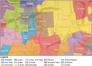
Recent research into the much smaller town of Colchester – the ancient Roman capital of Britannia, Camulodunum – has given the opportunity to explore these issues in a setting perhaps more typical of the wider late medieval urban experience. Colchester, including its suburban port of Hythe, had 10 parishes throughout the medieval period and until reform in the mid-nineteenth century. Regression of nineteenth-century maps has allowed reconstruction of the parish boundaries in GIS, opening the opportunity to geocode social and economic data.Footnote 23 However, while the most central of Colchester's parishes, St Runwald, St Nicholas and St Martin, were equally small in scale to those found in the square mile of the City of London, many others were both large, and, potentially more problematically, were discontinuous (Figure 4). The parish of Holy Trinity had no less than five detached portions. The relative paucity of documentation for the town's property market and ecclesiastical administration in the early modern period makes it very difficult to establish whether these large numbers of detached portions existed in this form in earlier eras. It is difficult to ascertain whether they were a product of the dissolution of the monasteries and incorporation of former abbey lands into parishes; or whether they were a product of later requirements for parochial lands for schools, poor relief or cemeteries. This administrative geography makes geocoding the residences of individuals based in their parish of residence potentially very problematic. However, the much smaller scale of the town allows for a more personal and intuitive understanding of its spatial and social configuration.
Parishes of nineteenth-century Colchester overlaid on Sparrow's map of Colchester 1767, showing the undeveloped nature of most detached portions of parishes (base map courtesy of Essex Record Office)

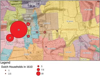
Work with the records of the Dutch Church of Colchester, one of the largest communities of exiled Protestants outside of London, from the sixteenth and seventeenth centuries has provided rich material for analysis.Footnote 24 The earliest topographically surveyed map of the town (James Deane's ‘Ichnography of Colchester’, 1748) reveals that the many detached parts of the parishes shown in the nineteenth-century maps were very sparsely inhabited at the earlier date. The decision was therefore made to use the main portion of the parish, containing the parish church itself, to geocode data that describes individuals by parish of residence (Figure 5). Even then, in this relatively small town, many of the parishes were rather irregularly shaped, and the majority of the development was concentrated in the centre, which was also where their churches were to be found. Geocoding was therefore carried out using co-ordinates selected manually at the position of the church building itself. This is another approach to assigning an artificially precise GIS co-ordinate to imprecise historical data, but rather than using the simple geometric centre of the spatial unit that was used in the historical textual description, it relies upon a more nuanced and explicitly subjective ‘vernacular’ approach retrospective understanding of spaces.
Distribution of ‘Dutch’ households in Colchester, by parish, 1610 (base map courtesy of Essex Record Office)

Conclusion
The application of GIS as a means of spatially analysing the social and personal characteristics of late medieval and early modern cities has provided valuable new insights, but clearly also comes with particular challenges. Most significantly, quantitative analysis of documents such as deeds and wills has helped to unlock something of the qualitative framework in which their creators might have viewed them. Late medieval London is a context with a great wealth of shallow records, but a dearth of deeper records, which is a pattern that is typical of a great number of historical situations. In contexts like this, spatial approaches such as GIS offer great potential to make sense of sources that offer much in breadth, but little in depth. Research on other urban contexts, ranging from Bisschops’ reconstruction of fifteenth-century Antwerp's commercial geography from the records of Aldermen's Registers, to Sam Griffiths’ analysis of eighteenth-century Sheffield trade directories, and Katrina Navickas’ analysis of the spaces of protest in industrial Manchester, have exploited the ability of GIS to help make sense of the confusing mass of data contained in urban records.Footnote 25
The process of assigning GIS co-ordinates to a record from the late medieval or early modern periods requires us to engage with the vernacular understanding of place which framed those records. Once effectively translated into the geometrical spatial paradigm that we are now more familiar with, this allows us to employ the GIS to gain new insights that simply would not have been feasible using traditional methods. The dynamic spatial queries which are possible using GIS have in this case allowed exploratory analysis of the relationships between spatial distribution within a city and all kinds of demographic, social, economic and religious factors. The ability to use a geocoded body of data in an exploratory way is one of the greatest advantages of this approach: even if certain queries do not necessarily always supply firm conclusions or maps suitable for publication, they invariably help to guide and shape further research, and develop the researcher's understanding of the urban environment. It is noteworthy that despite looking for evidence of geographical networks, connections and patterns of clustering, we historians seldom, if ever, make use of the formal tools offered in GIS to identify, measure and quantify these phenomena. This represents a significant recognition of the limitations of applying GIS methodologies to historical data: while we can assign spatial attributes to our data, we almost invariably (especially for earlier periods) lack the accuracy that would make quantitative analysis of precise distances and connections at a city-scale meaningful. Nonetheless, this does not undermine the value of applying GIS to historical urban data: visualization and purely exploratory spatial data analysis can be invaluable in guiding qualitative analysis.
It is impossible to escape the tension between the qualitative and relative spatial framework embodied in vernacular pre-modern historical records, and the Cartesian quantitative precision of a GIS. However, it is possible to bring these two epistemologies together with a suitably nuanced and sensitive approach to what the results can, and cannot, tell us. At the most basic level, maintaining a consistent ‘lowest common denominator’ ensures that results of mapping are coherent and meaningful. Accepting that while locations must be specified with precision, that does not mean that they are accurate, is much easier when a consistent approach is taken. When the ‘address’ data available for geocoding only describes an administrative unit such as a parish, the use of an arbitrary location associated with that unit, such as its geometric centre, or in the case of a parish, its church, makes this compromise more visible than would be the case if arbitrarily selecting individual or random locations. Naturally, this will limit the range of geographical and statistical analyses that can be conducted using the geocoded data – statistical measures of density would be greatly compromised by the location of many records at the same few spots, for example – but this is a reflection of the underlying data. Used appropriately and with caution, databases and GIS really do allow a fresh perspective on some of the most well-known of late medieval and early modern sources.
Supplementary material
The supplementary material for this article can be found at https://doi.org/10.1017/S0963926820000164.