
The Red River Delta in Vietnam is divided into three parts: the fluvial-dominated mid delta, where the capital Hanoi is located; the tide-dominated eastern plain, centred at Hải Dương (hereafter the eastern delta); and finally, the wave-dominated southeastern plain, where the current course of the Red River is, centred at Nam Định (hereafter the western delta).Footnote 1 Up to the tenth century, most of the sub-prefectures under Chinese rule were located in the upper eastern delta and the upper-mid delta.
This coastal area had been important to Jiaozhi (one of the names used by China for Vietnam) under Chinese rule (second century BCE to early tenth century CE) as well as independent Đại Việt, whose first capital for 41 years (968–1009 CE) was in Hoa Lư (Ninh Bình province). In 1010 the newly founded Lý dynasty moved its capital to Đại La, the site of the Tang Annam Protectorate office, today's Hanoi, and renamed it Thăng Long (ascending dragon). Although the same city was adopted by the Tang Annam protectorate and the Lý as their administrative centre, the Tang had regarded the eastern delta as crucial because Đại La linked its capital Changan with the coast, while the Lý dynasty was a strongly riverine polity.
John Whitmore has drawn our attention to the multiethnic coastal area of the early Đại Việt and its significance for Vietnamese history.Footnote 2 Building on his focus, this article situates the eastern coastal area of the Red River Delta within its natural environment to better understand how human actions and nature jointly shaped the region in the first four hundred years of Đại Việt's independence, and their long-term impact on Vietnamese history.
Population in the Lý period
Although in the second century BCE northern Vietnam (Jiaozhi) was the most densely populated area in the Han Empire's southern coast,Footnote 3 the situation had changed dramatically by the tenth century. The reasons for this were threefold. First, as Michael Churchman shows, between the third and sixth centuries Sinitic-speaking settlers were concentrated in key centres in coastal-southern China, such as Nanhai (Guangdong coast), Hepu (Guangxi coast), and Jiaozhi, while vast areas of present-day Guangxi were inhabited by the Li and Lao, who spoke Kam–Tai languages. These non-Han chiefdoms largely cut off the much more ‘civilised’ Jiaozhi from central China and, importantly, Han Chinese migration to Jiaozhi for over three hundred years.Footnote 4 Second, Guangdong's economic position greatly improved in the eighth century with the opening of the Dayu Mountain road and the linking of Guangzhou to the hinterland. From the early eighth century onwards, an unprecedented abundance of goods flowed from the hinterland to Guangzhou for trade, eclipsing former rival Jiaozhi. A third and equally important factor was that, by the ninth century, Persian and Arab merchants — the new princes of the Nanhai trade — chose to sail directly to Guangzhou on the open sea, cutting out Jiaozhi and many of its trading partners down the coast.Footnote 5 While the first factor greatly reduced the inward migration of the Han Chinese to Jiaozhi, the latter two factors may have encouraged outward migration from Jiaozhi. In the ninth century, the combined number of households in north and central Vietnam never exceeded forty thousand, or less than half the regional total recorded at the height of the Han period.Footnote 6 By the time of its independence in the tenth century, Đại Việt was anything but densely populated.
The newly independent Đại Việt was largely governed by local strong men, ‘big men’ whose status was determined, in part, by the number of bonded people they managed to amass. Next to trade, raids were the most effective means of obtaining manpower. Slave raids were common practice among the people of Lingnan (southeastern China) and Annam. The Tang records are filled with descriptions of such raids, and the trade in slaves belonging to different tribes in Guangdong, Hainan and particularly Guangxi. Manpower was as precious in tenth-century Guangxi as it was in Jiaozhi. Guangxi officials often quietly accepted the exodus of Viet people from Đại Việt, without turning them back. This caused disputes and directly led to the Việt king Lê Hoàn's raid of the Guangxi coast in 995.Footnote 7 These accounts provide a context for Việt attacks on nearby regions. Raids were carried out throughout the Former Lê period (980–1009) which preceded the Lý dynasty:
982: Lê Hoàn ransacked Champa and captured ‘countless’ soldiers, several hundred court ladies and one Indian monk.
995: Lê Hoàn raided Qinzhou at the Guangxi coast and captured 113 men and women.
997: Lê Hoàn attacked the Hà Đông area (near present-day Hanoi), which had been occupied by the Ngô family, and returned with the captives.
1008: In attacking the Tai-speaking peoples in the Tuyên Quang area, Lê Hoàn's son captured a few hundred people and horses.
1008: Attack on Nghệ An with captives taken.Footnote 8
Records of raids are not lacking for the Lý dynasty (1009–1225) either:
1044: King Lý Thái Tông attacked Champa and captured over 5,000 people and 30 elephants.Footnote 9
1048: Lý Thái Tông attacked Ai Lao and obtained ‘many people and animals’.Footnote 10
1060: The emperor's son-in-law, an official of Lạng Sơn Thân Thiều Thái, recaptured the soldiers who had fled to the Song, together with ‘countless’ men, women, cattle and horses.Footnote 11
1069: Attack on Champa, with the capture of King Chế Cự and 50,000 people.Footnote 12 Chinese sources record that the Song emperor heard that the ‘majority of Cham households were captured by Jiaozhi’.Footnote 13
1075: Attack on the Guangxi coast: over 3,000 people from the three prefectures were captured and forced to enter Đại Việt.Footnote 14 Only 221 of them were sent back in 1079.Footnote 15
1119: Attack on Hoà Bình; the chief and ‘a few hundred people’ captured.Footnote 16
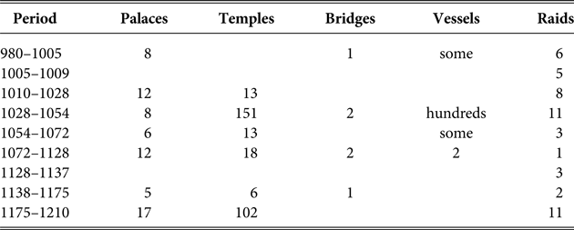
The raids listed above were clearly aimed at treasure, horses, cattle, and most importantly, people. While some of the captives may have been sold around the region, most of them were used as court servants. A massive number of palaces, towers, gates, temples and pagodas were constructed between the end of the tenth and twelfth centuries, at a time when the country was still underpopulated and manpower under direct court control was even more limited.Footnote 17 Song and Cham prisoners of war were resettled around the Lý stronghold — the capital and the upper Red River Delta — where they became an important resource for court building projects.Footnote 18 Vietnamese scholar Trần Quốc Vượng points out that Cham prisoners were used to build the main pagodas, towers and royal travel lodges. The famous pagoda of the Lý period in Hanoi, Tháp Báo Thiên, was built by Cham prisoners, and Cham inscriptions were found on the bricks of the Lý royal palace, in the recently excavated Thăng Long citadel.Footnote 19 Raids therefore went in tandem with the Lý's construction projects. Table 1 shows the correlation between raids and court construction between the tenth and twelfth centuries.
Court construction projects and number of raids in Đại Việt, 980–1210 CE

Source: Đại Việt sử ký toàn thư [Chronicles of the Great Viet] (Tokyo: Tokyo University, 1984).
Given the shortage of manpower, the court guarded its bonded population carefully; all were tattooed so that no other local strongmen could claim them. When over 3,000 people from Guangxi were captured by general Lý Thường Kiệt in 1075, men over 15 years old had ‘thiên tử quân’ (天子軍 ‘army of the son of the heaven’) tattooed on their foreheads; those over 20 were tattooed with ‘đầu nam triều’ (投南朝 ‘volunteered to the South dynasty’, i.e. the Lý); and women had ‘quan khách’ (官客 ‘official guests’) tattooed on their left hands.Footnote 20 While in general, bondsmen would have three to four characters tattooed on their foreheads (for men), male criminals who became court slaves were tattooed with six characters, and women were tattooed with two. Those who dared to try to flee were severely punished by having some 50 characters tattooed on their faces, and receive 100 lashes.Footnote 21 This punishment contrasts with the rather more lenient treatment of murderers: instead of the death penalty, the law allowed for the offender to pay monetary compensation to the victim's family.Footnote 22 All this suggests a shortage of manpower under the Lý.
The eastern delta under the Lý
The Lý dynasty was a local power and its territory was limited. Yumio Sakurai points out that the Lý only directly controlled the capital and lower western delta; Momoki Shiro further indicates that its strongholds were in Thanh Hoá, Thái Nguyên and Sơn Tây. Both scholars agree that the outlying territories were semi-autonomous areas controlled by local powers.Footnote 23 Whitmore places the Lý-controlled area at the ‘mid-river core of the delta’, and suggests that the Lý Đại Việt, like Angkor and Pagan, was focused on the upper, mid-river portion of its territory, and paid little attention to the coast.Footnote 24 This largely leaves the eastern coast out of the map of the Lý.
This is intriguing, as the eastern delta was where the most rapid growth of the Red River Delta occurred between the first and tenth century.Footnote 25 Recent archaeological findings indicate that between the seventh and ninth centuries Tuần Châu island in Quảng Ninh was a major ceramic production centre for the Tang Annam Protectorate. Tuần Châu is located on the waterway to China, and the ceramics uncovered here are described as among some of the finest in Vietnamese history.Footnote 26 The eastern delta and its coast would have been the area where Annamese Middle Chinese (as termed by John Phan), was spoken.Footnote 27 This language, as Keith Taylor points out, could be a dialect of a broader Southern or Southwestern Middle Chinese of the tenth century.Footnote 28 There had likely been a strong Chinese community on the coast of the eastern delta, according to Taylor. This was where Khúc Thừa Dụ, a recently arrived Chinese immigrant, rose and declared himself governor of Annam in 906, an act that established the path for Vietnam's independence. Khúc was from Ninh Giang prefecture, Hải Dương. The eastern delta was also where Wu Hun (Vũ Hồn in Vietnamese), a protector-general in the 840s, had settled.Footnote 29 The Vũ family became the most prominent family in Mộ Trạch, Hải Dương, producing many scholar-officials in the Trần and Lê periods. The family genealogy boasts three government ministers and eighteen doctoral students (tiến sĩ).Footnote 30 Interestingly, none of the Vũ family members served in the Lý court in the first two centuries of Đại Việt's independence. How do we explain this gap?
The elite living on the eastern coast was likely excluded from the Lý circle, if we use the Thơ văn Lý Trần (a literary anthology of the Lý and Trần period) as a ‘Who's Who’ during the four centuries of Lý and Trần rule. Out of the 26 people listed under the Lý, only two, both monks, were from the eastern delta. The place of origin of the elite changed completely in the Trần era (1225–1400): 29 of the 35 people listed were from the eastern delta.Footnote 31 This striking change strongly suggests that the Trần ruling base was at the coast, particularly in the east.
Whitmore asks how ‘the region to the East — downriver, the lower delta, the coast — fit into the Lý regime’? Answering his own question, he provides an important insight: ‘It does not appear to have been of very great significance and possibly was of different ethnicity’.Footnote 32 But if the eastern coast was where the overseas trade took place, and the wealth was, why did the Lý not tap into the resources of this area instead of abandoning it to other ethnicities? Here is a hint from the Việt chronicles:
During the Lý dynasty, when the ships from China came to visit they had used the seaports of Diễn Châu [Nghệ An] and Tha Viên [unidentified location] as entry points. Since then [1148] the sea routes had changed and the seaports became dry and shallow, [therefore merchants] tended to gather at Vân Đồn, and this was why [the court] ordered them to set up [the government offices] there.Footnote 33
This source indicates that the Lý's major ports were at the central coast next to Champa, not the eastern coast, next to Guangxi, and that this shift to Vân Đồn was caused by environmental changes in the central coast in the mid twelfth century. Between the tenth and twelfth centuries the eastern coast was probably a stretch of wilderness, largely left to outsiders, including Sino–Viet descendants such as the Vũ family, Tai speakers, recent migrants from Fujian, and Vietnamese and Dan fishermen.Footnote 34 Quang Ninh, the province bordering Song China, was where fishermen and traders indiscriminately colluded with refugees, smugglers, bandits and pirates.Footnote 35 James Anderson observes that the Lý pulled back from the earlier Hoa Lư coastal links and focused on the montane trade in the eleventh century. This was perhaps partly because the Northern Song was focused on northern affairs and thus little commerce was carried out in the Gulf of Tongking area. It was also partly due to the fact that the Lý's political control was limited, and thus they had no power base in this area. As Anderson points out, along the Gulf of Tongking coast, people at the margins of both kingdoms ‘had for centuries continued to make local alliances and local deals in their own interests that largely ignored central authorities’.Footnote 36
At almost the same time that the Lý's major port in central Vietnam suffered from siltation, events in China exerted an influence on the region. The Guangxi coast, which had been half-deserted following the collapse of the Tang dynasty, enjoyed a sudden boom in commodity exchange. Because of the urgent need for horses for its military, the Southern Song (1127–1279) allocated a huge amount of its annual budget to the horse trade in the Yunnan–Guangxi–Đại Việt border area. This horse trade spurred regional growth through stimulating trade, and created a commodity exchange system within the Jiaozhi Sea (Gulf of Tongking) area.Footnote 37
Chinese migration in response to the commercial boom in this region would have contributed considerably to population growth in Đại Việt in the twelfth century. The magnitude of this growth is visible in a detailed report on voluntary and forced migration into the Lý Đại Việt by a Guangxi official named Fan Chengda in 1170s:
Moreover, the indigenes of their country form much less than half [of the population]. [There are] people of [our] territory [who] travel to the south [and] entice people, male and female, to become menials. [They] grab them and take them into the mountain grottoes of [this] territory, binding and selling them for two liang of gold. [From this] territory's grottoes, [they] move and sell them into Jiaozhi [Ðai Viet], receiving three liang of gold (for each one). Yearly, there are not less than 100,000 [such people]…
There are also accomplished scholars, Buddhist monks, Daoist practitioners, and clever artisans, [all] becoming absconders [who] have lost the [imperial] mandate. Those who flee are very many… [The Vietnamese thus] grab and plunder the sold men and women as well as the scholars [who] cross the frontier and enter [their land].Footnote 38
The statement that Vietnamese formed much less than half the population of the entire Đại Việt is of course an exaggeration. Yet, as Whitmore points out, Fan ‘was looking at the country through the coastal prism of the Lower Delta, and so his words make sense mainly for this area, the one with which the Chinese would have had the most contact and familiarity’.Footnote 39 It is no coincidence that the port of Vân Đồn was opened in 1148, only two decades after the founding of the Southern Song dynasty.Footnote 40 The Chen family (later to become the Trần imperial family) might have arrived at the eastern coast around this time, if not earlier. According to Trần Quốc Vượng, the Trần had wandered around the eastern coast before moving to Thiên Trường.Footnote 41 The fact that the huge ancestor temple (Đền Thái) complex of the Trần royal family is situated in Đông Triều district, Quảng Ninh, confirms this view.Footnote 42 The Quảng Ninh–Hải Dương area (particularly Đông Triều and Chí Linh districts) saw a concentration of the estates of the leading Trần princes, eight of whom were crowded on this limited strip. The flourishing commerce on the northeastern coast would have attracted migration from the upper Red River Delta,Footnote 43 from where many of the Trần elite came. Momoki Shiro observes that many famous officials such as Trần Khắc Chung and Phạm Sư Mạnh came from Quảng Ninh and Hải Dương and that the Trần ‘relied heavily on the rule of such regions as the eastern edge of the delta, the lower delta and the southern provinces, where not only trade thrived but agricultural reclamation advanced remarkably’.Footnote 44
The ethnic intermingling and integration on the northeast coast led to a new stage in the interaction of Northerners and Southerners (Chinese and Vietnamese). As Whitmore points out, the maritime dimension facilitated by the intensive interactions with the Chinese and Song culture, led to a boom in the literati in this area.Footnote 45
Population boom in the Trần period
Independent Đại Việt emerged during favorable climatic conditions which lasted for about three hundred years. Data reconstructed from the tree-ring widths of cypresses in southern Vietnam indicates that between 900 and 1250–1300, Southeast Asia enjoyed unusually warm, La Niña-like conditions, which tended to produce greater annual volumes of rainfall, longer monsoons and shorter dry seasons.Footnote 46 This was particularly helpful to the success of the rice crop in the Red River Delta during the Lý and Trần periods. On the newly reclaimed land along the coast the fifth-month rice harvest (lúa chiêm) was critical to the population's survival,Footnote 47 but was vulnerable to droughts in spring. Three centuries of stable rain-fed harvests would have greatly encouraged the expansion of land cultivation and stimulated fertility. These favorable ‘wet centuries’ thus helped to jump-start the charter state expansion of the time, that saw so many well-organised, new kingdoms flourish.Footnote 48 The rapid growth of the eastern delta occurred within this broad background, contemporaneous with the golden age of Angkor and Pagan. In all three cases, as Victor Lieberman points out, a period of greatly enhanced rainfall accelerated cultivation, construction and population growth.Footnote 49
Đại Việt's population doubled to three million between 1200 and 1340, according to Sakurai.Footnote 50 By the mid fourteenth century the average population density of the delta was 150–180 people, and one to two villages, per square kilometre.Footnote 51 The population density in the northeastern delta would have been higher than this average, judging from the early fifteenth century data (see below). There is no data to gauge the extent of Chinese migration to Đại Việt in the twelfth century, but the Lý's recorded raiding stopped in the late twelfth century, suggesting that Chinese migration and raiding may have been somewhat correlated. This was also a period of Chinese migration into other parts of Southeast Asia in ‘a continuous flow’, as pointed out by Anthony Reid.Footnote 52 Whitmore notices that in this period, draining and poldering were carried out in both south China and the lower delta of Ðai Việt. This led to agricultural intensification and, together with growing commerce, a greater concentration of population and wealth in this area. Owing to this rapid growth, by the thirteenth century, land had become scarce.
This explains why the Trần court issued a somewhat desperate plea in 1266 that the aristocracy, all ‘princes, princesses, king's son-in-laws and court ladies’, gather ‘landless and drifting’ people to become their slaves. These people were urged to convert wild and uncultivated land into estates. From then on, aristocrats ‘took land settlements as their estates’ (điền trang 田莊).Footnote 53 Nguyễn Thị Phương Chi indicates the fundamental differences between the newly emerged estates (điền trang) of the Trần dynasty and the traditional manor estates (thái ấp 采邑) which had existed since the Lý period: the traditional manor estates were granted by the king to aristocrats for use in one generation, while the Trần estates were set up specifically as a privilege for aristocrats who opened up coastal land. Thus, a manor was essentially the king's property, while the estates became the private property of the aristocrats who opened up and transformed the land.Footnote 54
The Trần would have seen the điền trang as the best way to organise the surplus and drifting population of the time, and in many ways this seems to have been effective. Most of these estates were built along the coast, as a later record elaborated: ‘In the earlier period, the royal families tended to make their slaves build dykes and weirs on the coasts to stop the salty water. After two to three years, the land would be ready to cultivate. Those slaves would marry each other and live on the lands. [This was how] many of the điền trang were founded.’Footnote 55 As this source indicates, this process involved blocking the sea with seawalls, desalinating the land by connecting it to a river system, and creating polders to enable the cultivation of crops. Although we do not know the size of these estates, Momoki Shiro estimates that they were quite large and numerous, citing the frequent appearance of ‘điền trang’ in his collection of Trần epigraphic materials.Footnote 56 It was at this time that the present-day western coast of Thái Bình and Nam Định began to be populated.Footnote 57 While the Trần manor estates (thái ấp) were concentrated in the Quảng Ninh and Hải Dương area, the Trần estates (điền trang) were mainly built in the Nam Định and Thái Bình areas.Footnote 58 This reflects a trend of migration from the eastern delta to the western coast, which changed the landscape of the delta.
The newly opened land accommodated the fifth-month rice harvest (lúa chiêm), which could endure the saline-alkali soil of the coast and also demanded less fertiliser. Sakurai points out that while crop cultivation under the Lý was relatively small scale to adapt to the environment, the Trần's expansion to the coast and the boost it received from the fifth-month rice harvest remarkably increased agricultural productivity.Footnote 59 Indeed, the fifth-month rice harvest was ‘the spearhead for the opening up of the lower Red River delta’.Footnote 60 Cultivation of the fifth-month rice at previous swamp or swidden coastal areas seems directly linked to the Trần period's population boom. As described by a nineteenth-century Vietnamese scholar: ‘Villages were as many as sand in the river or stars in the sky and spread evenly, no longer would people survive like in the previous periods when everyone had to find higher ground on which to live.’Footnote 61
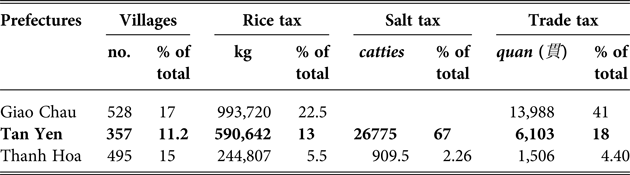
Ming data on the contributions of Jiaozhi (Đại Việt) under Chinese occupation in the early fifteenth century is the closest we can get to an image of the Trần economy. This data reveals that Tân Yên's (Quảng Ninh and Hải Dương) economic contributions were second only to the capital's, contributing 13 per cent of all rice, and paying 67 per cent of the salt tax (the most important tax in Ming China), and 18 per cent of the trade tax (Table 2). The table shows the concentration of population and economic activity in fourteenth and early fifteenth century Đại Việt around the eastern delta. The western delta, which is today the most densely populated area in Nam Định and Thái Bình, was home to just over 10 per cent of the population, who contributed only 16 per cent of the rice and less than 3 per cent of Jiaozhi's total trade tax.
The following data shows the three most densely populated areas in early fifteenth-century Đại Việt.Footnote 62
Village numbers and tax distribution of the Jiaozhi (Đại Việt) under Ming occupation, 1407–27
Source: Léonard Aurousseau and Émile Gaspardone, Ngan-nan tche yuan (Hanoi: Imprimerie d'Extrême-Orient, 1932), pp. 83–100.
Economic and population growth was particularly evident in Chí Linh and Đông Triều just up the Bạch Đằng River in the thirteenth century, and this new energy spurred ceramic production in the area. The following section will examine this industry and its implications for the environment of the eastern coast.
Ceramics centres in the eastern delta: Vạn Yên (13th–15th century) and Chu Ðậu (14th–16th century)
In the early 1990s in Chí Linh, Vietnamese scholars uncovered an area of 40,000 square metres at a depth of 2 metres, and found more than 100 kiln foundations with tens of thousands of valuable artefacts. The location was in Vạn Yên village, which had flourished in the thirteenth and fourteenth centuries as a ceramics centre, about one century earlier than the famous Chu Đậu.Footnote 63
The Chí Linh area was ideal for ceramic production. It was located next to the Thái Bình River and Quảng Ninh, where the supply of kaolin clay was plentiful and water transportation was at hand. Its size suggests that this was a large, organised production. The Chí Linh area was the manor estate of Trần Hưng Đạo, a prince and the most powerful general of the Trần dynasty. There is a possibility that the ceramic production here was a part of Trần Hưng Đạo's private manor estate economy, which was operated by his bonded population. The location was excellent and the domestic market would have certainly been open to this prominent court figure; production could have carried on forever if the master so wished. But one crucial element was not in unlimited supply: firewood for fuel.
The eastern delta used to be covered by boundless forests of ironwood and pine trees — the former ideal for shipbuilding and the latter superb for making high quality porcelain, given the strong, even and lasting heat it produces.Footnote 64 This valuable timber was surely utilised. Raman spectroscopic analyses of samples from Chu Đậu indicate that the clay body had been fired to a temperature of 1200°C–1400°C and shows characteristics of porcelain.Footnote 65
Vạn Yên and Chu Đậu's ceramic production sites were huge, a total of 140,000 square metres.Footnote 66 How much fuel was needed to sustain such an enormous scale of production? In the absence of Vietnamese sources, figures from China's ceramic-producing centre, the Jingdezhen, give us some idea of the area of forest needed for ceramic production. In Jingdezhen, to make 1,000 pieces of small ware one would need 80–100 stakes of timber.Footnote 67 The Tiangong kaiwu [Encyclopedia of technology] published in the Ming era gives a figure of 50 kilograms of fuel for every 65 kilograms of pottery.Footnote 68 In Jingdezhen there is a saying which provides the shortest answer to the cost of fuel: ‘One li (60 metres) of kilns cost 10 li (600 metres) of forest.’Footnote 69 The two centuries of ceramic production in Vạn Yên alone would have depleted the forests around Chí Linh, if not totally stripped them. Chu Đậu, where the finest of Vietnam's late fourteenth and early fifteenth century ceramics were made, would have had an equally large, if not larger output. In one underwater excavation from a shipwreck off the Chàm Islands in 1997 to 1999, scientists recovered over 240,000 pieces of intact ceramics, together with thousands of fragments.Footnote 70 To produce all the ceramics on this ship alone would have required that a considerable number of trees be cut down, and this single cargo was but one of hundreds carried by ships to Southeast and West Asia in the fourteenth to sixteenth centuries.
There was an even more environmentally damaging aspect to the thriving ceramics industry in this period. Other than the high quality ceramics made by experienced craftspeople, many untrained people were attracted to the trade, obviously driven by profit. Their presence is clearly demonstrated in the large quantity of mid-fifteenth-century Vietnamese ceramics recovered in 1995 from the Pandanan shipwreck site off the coast of Palawan, in the Philippines. Although there was only a small quantity of Vietnamese blue-and-white ceramics, they showed a wide variation in quality. According to Kerry Nguyen-Long, this indicates that the items were made in different workshops, indicating an over-stretched industry, with a hectic output that outpaced the availability of experienced technicians.Footnote 71 This increase in production would have demanded even more forest clearing, given that inexperienced craftspeople and kiln operators would have wasted more fuel than highly trained, skilful ones.
This area was also the site of the two famous battles of Bạch Đằng, against the Southern Han in the tenth century and the Mongols in the thirteenth century, respectively. Both battles applied the same military tactic: a barrier of large poles was planted in the bed of the Bạch Đằng River.Footnote 72 While both battles would have used large amounts of logs, the cost to the forest in the tenth century might not have been as damaging as that in the thirteenth century, when ceramic production had already used enormous tracts of forest. Since intense naval battles were fought, a large number of vessels must also have been built in this area.
One other important economic activity in this area was salt making. As mentioned above, in the early fifteenth century, 67 per cent of Đại Việt's salt tax came from this area, and one official salt warehouse was located in Chí Linh district.Footnote 73 Salt production also would have required considerable firewood.Footnote 74
Construction of Buddhist temples
The forest was taxed by another major undertaking of the Lý and Trần dynasties — Buddhist construction projects. Buddhism flourished under both these dynasties; many ordinary people chose to be monks and nuns, and a huge number of large temples and pagodas were constructed. As observed by a fourteenth-century scholar, Lê Quát: ‘The number of buildings with their bells and drums is equal to one half of the population.’Footnote 75 The vast number of Buddhist temples in existence during the Lý and Trần dynasties is confirmed by a later source, Truyền kỳ mạn lục:
Temples sprang up everywhere. People who shaved their heads to enter the monkhood equalled half the population.Footnote 76 Especially in Đông Triều district, belief was extreme. Temples were built everywhere: there were more than ten temples in each large village, and even smaller villages had five to six. The temples are hedged on the outside, and painted or gilded with vermillion and gold inside.Footnote 77
King Trần Nhân Tông built a large group of temples and pagodas on Mount Yên Tử in Đông Triều district, Quảng Ninh, making this area the most important Buddhist centre at the time, as indicated in a thirteenth-century couplet: ‘He who is resolute to lead a Buddhist religious life/ will be satisfied only if he has been to Yên Tử.’Footnote 78 Mount Yên Tử was by no means remote during the Trần period, and reflected the idea of a proper space and place of dwelling for monks, as articulated by the second-generation master of the Trúc Lâm (‘Bamboo Grove’) Zen sect and disciple of King Trần Nhân Tông, Pháp Loa (1284–1330):
When, having been enlightened by the genuine path, one should find a temple for his residence, and avoid an unwholesome climate with malaria.… Also be aware that the place should not be too close to the population but also not too far away, because closeness creates noise but distance incurs isolation and helplessness.Footnote 79
Pháp Loa's temple, the Quỳnh Lâm, was in the same district as Mount Yên Tử. Quỳnh Lâm, the most important temple of this period, was enormous. In 1314 alone Pháp Loa built 33 buildings within Quỳnh Lâm's temple compound; within a single year (1329), Pháp Loa ordained 15,000 monks and nuns, all of whom would have had to be housed in a temple.Footnote 80 These temples were much larger than those of later periods, according to Vietnamese scholars.Footnote 81 They also served as centres of agricultural and craft production, particularly for processing aromatic products such as joss-sticks,Footnote 82 producing surpluses beyond what was needed by the establishment itself, not unlike those of the pre-Angkor temples in Cambodia.Footnote 83 Aromatic products were on top of the list of tributes from Vietnam to China for centuries. As such, big temples attracted settlements and associated building projects that also involved cutting down many trees, to clear land and obtain clay and fuel for producing bricks. Another Buddhist-related construction which required plentiful timber for fuel was bronze casting. Pháp Loa alone was said to have cast 1,300 bronze Buddha statues.Footnote 84 A large percentage of them would have been close to his temple in Đông Triều at the cost of the forests. The speed of logging in this area likely surpassed the capacity of the forest to regenerate.
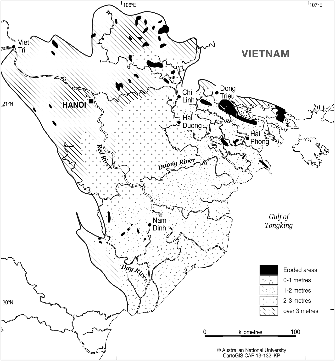
Such intensive human activity in this area between the twelfth and fifteenth centuries had an impact on the landscape of the Red River Delta. The terrain along the Bạch Đằng River was the most notably damaged, as confirmed by the leading Vietnamese geologist, Vũ Tự Lập: “The only area that saw a long and stretched piece of ‘worn-out’ (bóc mòn) land is the right bank of the Bạch Đằng River … A large section of this area is now bare hills, worn out land and gravel, although it used to be covered with boundless ironwood forest.'Footnote 85
Natural disasters of the 13th–14th centuries and the end of the boom
As mentioned, the unusually warm La Niña-like conditions, which produced more evenly distributed annual rainfall between 1000 and 1250, provided an ideal environment for Đại Việt's population growth and the reclamation of coastal land for agriculture and habitation. The first half of the thirteenth century was an especially wet period in Vietnamese history. Never before were so many floods recorded. In the eleventh century, six floods were recorded; in the twelfth century, five; but in the thirteenth century there were sixteen floods — fourteen of them between 1236 and 1270. In 1236, 1238 and 1243 the palaces were inundated. The worst one seemed to be that in 1270, when the streets of Thăng Long had to be traversed by boat.Footnote 86 The first large hydraulic project on the Red River, the Đỉnh Nhĩ (‘Cauldron handle’) dyke was built against this background, in 1248. By the fourteenth century, the dyke system of the Red River Delta was basically completed, according to Yumio Sakurai. Dykes built after the fourteenth century were merely an expansion of these existing networks.Footnote 87
These man-made changes seemed to have altered the course of the tributaries of the Red River, and substantially reduced the volume of water discharged into the eastern delta.Footnote 88 High dykes blocked the natural flood pulse and deprived the downstream delta of key nutrients. To make things worse, in contrast to the abundant rains in the mid-thirteenth century, frequent droughts occurred from the late 1260s. This resulted in a great famine in 1290 and again in 1291; so many people starved to death that bodies were strewn over roads.
In the latter period, rebellions broke out in 1343 in the Hải Phòng, Quảng Ninh and Hải Hưng areas, the heart of the eastern delta, and the area containing the highest number of aristocratic estates.Footnote 89 The majority of rebels were slaves. In the following year, a larger and longer rebellion broke out, just across the Bạch Đằng River in Đông Triều.Footnote 90 From there, the rebels occupied Chí Linh, the region where the former manor estate of Trần Hưng Đạo was based.
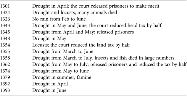
Why did rebellions occur repeatedly in this same area? There seem to have been two major reasons. First, the droughts would have hit the eastern delta especially hard, because the volume of water from the upper and mid Red River Delta had been greatly reduced by the Đỉnh Nhĩ dyke and other smaller water control projects. Second, the eastern delta suffered for the very same reason it had flourished in the previous two centuries. Yumio Sakurai points out that in the Trần era the fifth-month rice harvest was increasingly planted right to the delta's edges to produce larger yields.Footnote 91 This area would have included Chí Linh and Đông Triều, the centre of the estates and therefore the population. Sakurai defined the fifth-month rice as ‘the species of rice in the cold areas of the Red River Delta where the tenth month rice could not be planted because of the flood in summer’.Footnote 92 As late as the 1930s Pierre Gourou observed that a large part of the low-lying eastern delta ‘was inundated in the summer and only the fifth month could be grown’.Footnote 93 This means that the population came to depend solely on this harvest. The fifth-month rice, however, was particularly vulnerable to drought in spring and this was precisely what happened in the fourteenth century. Of the fourteen droughts recorded, eleven happened after the rebellion of the 1340s. Only two of them happened in summer and all the rest struck in the spring.Footnote 94
Elevation and erosion of the Red River delta
Droughts in Đại Việt, fourteenth century
The fifth-month rice harvest was dependent on rain brought by the northeast monsoon in spring, which is particularly unreliable in the Red River Delta area. Unlike all other south-facing deltas of Southeast Asia, the Red River Delta faces east. When the winters are too cold, the northeast monsoon pushes directly to the south and steers away from the delta and does not bring rain. This made agriculture in this area ‘extremely fragile’, as Sakurai points out. While the expansion of the fifth-month rice harvest to the coastal areas increased crop yield and spurred population growth, it also made the new settlements more vulnerable to drought and famine.Footnote 95 The repeated droughts in spring caused serious damage. A string of failed fifth-month rice harvests during the fourteenth century seems to have been one of the major reasons for rebellion among the people of the densely populated eastern delta. The Chronicles record: ‘The failed harvests and famine turned many people into bandits, especially slaves of princes.’Footnote 96 So many people lost their livelihoods and were forced into banditry that in 1360 the court ordered that aristocrats tattoo their slaves for identification. Those who did not have tattoos on their faces would be regarded as bandits.Footnote 97 The deterioration in economic conditions between the 1340s–1360s caused many peasants and skilled workers to lose their livelihoods and turn to banditry to survive. Many other people would have been forced to migrate to other regions, especially to the western delta.Footnote 98
While the Đại Việt in the Red River Delta had gone through an agricultural revolution between the eleventh and fourteen centuries with substantial forest clearing and encroachments up to the coast itself, neighbouring Nagara Cāmpa did not see such remarkable changes in terms of its terrain.Footnote 99 In these centuries the gap in population between the two polities would have increased significantly. Yet, the largely trade-based polity Nagara Cāmpa was not as hard hit as Đại Việt when the two centuries of favourable climate ended in the fourteenth century.Footnote 100 For one thing, Cāmpa did not have such a multitude of extra mouths to feed as Đại Việt, and its society would have been more stable than the latter. This may partly explain why the global drought of the fourteenth century and the repeated Cham invasions (in the 1370s) occurred during roughly the same period. Both greatly shook Đại Việt's economic foundation, and both seemed to have prepared the arena for the rise of Hồ Quý Ly (who would overthrow the Trần from the inside), and consequently the Ming invasion and occupation of the early 1400s.
The heyday of Vạn Yên's ceramic manufacturing in Chí Linh had also ended with the fourteenth-century droughts. Chu Đậu enjoyed its golden age in the fifteenth century and went downhill in the sixteen century. There were several other ceramic centres in Hải Dương, such as Ngói, contemporary with Chu Đậu, but all went bust in the late sixteenth century. The late Japanese archaeologist Nishimura Masanari showed that Kim Lan, another ceramic village in Bắc Ninh in the eastern delta, was nearly extinguished in the early or mid fifteenth century. It revived in the sixteenth century only to be abandoned again at the end of the seventeenth century.Footnote 101 The worsening ecology of the delta would have been an important reason for the ups and downs of these settlements and their ceramic production and signifies that the carrying capacity of the eastern delta had reached or approached its limit between the fourteenth and seventeenth centuries.
Chu Đậu's glory was only rediscovered when, in 1980, a Japanese diplomat visited Istanbul's Topkapi Saray Museum where he saw a fine ceramic vase. The thirteen words written underneath the vase revealed that it was made in Nam Sách, Hải Dương, in 1450. This was big news not only to Vietnam, but to the villagers of Chu Đậu themselves, who were no less surprised. Like Vạn Yên, although there had been a vast ceramics industry for centuries, it was abandoned so completely that in a few generations none of the villagers had any knowledge or memory that their ancestors had been superb craftsmen whose products were found in over sixty countries and had travelled halfway across the world to Istanbul.
The changed course of the Red River and the erosion of the banks of the Bạch Đằng impacted on navigation and commerce in the Gulf of Tongking. The waterways linking the capital and the Gulf of Tongking had been the region's major highway for millennia. By the early fifteenth century, however, this major waterway was no longer navigable by large ships.Footnote 102 The diminished carrying capacity of the Bạch Đằng River affected the fate of the major port of Vân Đồn, and hastened its decline at the end of the fifteenth century.