

INTRODUCTION (LCN, ZHA, EBT, DLS)
Recent studies of Classical cities have moved beyond locating major public spaces, establishing the layout of the streets and reconstructing the architecture of major public buildings. Approaches have included using intra-site field survey to investigate the ebb and flow of population or to evaluate variation in the use of different parts of a settlement over time (e.g. Whitelaw Reference Whitelaw2013; Bintliff Reference Bintliff, Vermeulen, Burgers, Keay and Corsi2012). Geophysical investigation has also become prominent as a means of understanding the layout and function of larger areas than can easily be excavated given modern methods and resource constraints (for a recent summary, see Donati and Sarris Reference Donati and Sarris2016). Research on the urban economy has reinforced the roles played by markets and by the physical space of the agora, which was the locus of institutional regulations about commerce (Chankowski and Karvonis Reference Chankowski and Karvonis2012; Oliver Reference Oliver2012; Archibald Reference Archibald2012; Bresson Reference Bresson2016, esp. 234–50; Harris, Lewis, and Woolmer Reference Harris, Lewis and Woolmer2016). At the same time there has been increased emphasis on the social implications of different spatial configurations of the city more generally, particularly in the context of domestic structures (e.g. Ault and Nevett Reference Ault and Nevett2005). Together, these and other approaches represent an increasing trend towards reconstructing cities both as complex, varied physical spaces and also as dynamic social and economic communities.
In this paper we suggest that by combining a range of traditional and emerging field techniques within a multi-scalar and multidisciplinary framework, a more holistic and coherent picture of a Greek city begins to emerge which has the potential to contribute to discussions at a number of levels. These range from comparative considerations of urbanism and state formation, through explorations of the particular developmental and organisational characteristics of Greek cities, to an in-depth understanding of the history, urban form and social dynamics of a single community. This argument is made with reference to fieldwork currently being undertaken at the site of Olynthos by the Olynthos Project. After introducing the site, we outline a range of the larger debates to which the study of this particular city aims to contribute, as well as some of the more site-specific questions being addressed. We then discuss the different forms of data being collected and the methodologies in use. Finally, we summarise what has been learned about the city so far, showing how some of the analyses are coming together to create a detailed, multi-scalar model of Olynthos as a dynamic community. Although work is continuing at the site, the results obtained so far go well beyond any conclusions that could previously be drawn based on the extensive legacy data from the site.
Background to the site
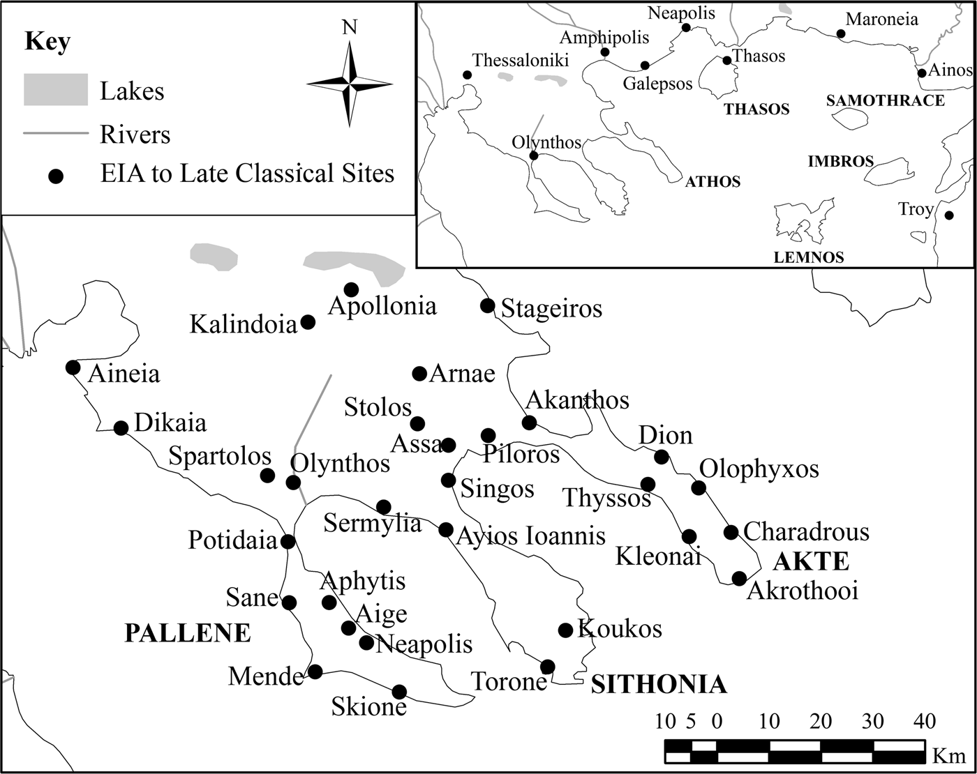
Olynthos is located on the Chalkidiki peninsula, northern Greece (Fig. 1). The archaeological remains occupy two flat-topped hills (the North and South Hills) and spill onto the agricultural land below, to the east. The site offers a variety of opportunities for the study of urban and social development, households and the economy: following the abandonment of a small, Neolithic community, the settlement is thought to have been re-established in the Archaic period. It seems to have been abandoned rapidly in the mid-fourth century bc, a fate which the literary sources attribute to the siege and sacking of the city by Philip II of Macedon in 348 bc (Diodorus Siculus 16.53.2–54.2; cf. Demosthenes 8.40; 18.48; 19.265; 19.342). Olynthos was not reoccupied in post-Classical times aside from a few Byzantine structures on the southern end of the South Hill. Most of the Classical settlement is therefore relatively well preserved, and the core areas, consisting of the North and South Hills, are under the ownership and protection of the Greek State.
The location of Olynthos within the Chalkidiki region, showing sites dating from the Early Iron Age to the Late Classical period (HP).

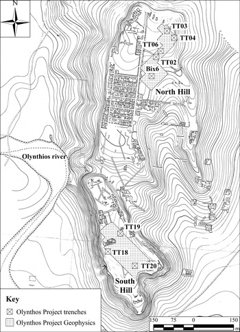
The general topography of the city was established by David Robinson, who excavated at Olynthos between 1928 and 1938 and dug extensively on and around the two hills (Fig. 2). He revealed a number of buildings on the South Hill, identifying it as the earliest part of the settlement. Much of Robinson's attention was devoted to the orthogonally planned North Hill, which he concluded was laid out in the late fifth century bc. He also worked on the plain below to the east of the North Hill, which he interpreted as an extension of the housing area on the North Hill, and at a variety of locations further afield. The project was published with comparative thoroughness (by the standards of the time) and admirable speed, in a total of 14 volumes, the last of which appeared in 1952 (Robinson Reference Robinson1929–52). The Greek Archaeological Service undertook excavation in a house on the North Hill under the direction of Ioulia Vokotopoulou in 1988 (e.g. Drougou and Vokotopoulou Reference Drougou and Vokotopoulou1989). A subsequent programme of extensive cleaning and restoration was carried out at the site between 1989 and 1994 (e.g. Athanasiou Reference Athanasiou1992; Protopsalti Reference Protopsalti1994).
Robinson's plan of Olynthos, showing the location and structures within his excavation trenches. The locations of the Olynthos Project trenches and areas of geophysical survey are also shown (HP).

Since the 1930s Olynthos has been known best for the houses on its North Hill, which have been used as the archetype for the pastas house (e.g. Graham Reference Graham1966; Drerup Reference Drerup1967) and even regarded as a source of information about the ‘typical’ Greek house (e.g. Nevett Reference Nevett1999, passim). The significant quantities of material recovered have also served as a basis for exploring patterns of domestic activity and the use of space (Nevett Reference Nevett1999, 53–79; Cahill Reference Cahill2002, passim), since few subsequent publications of Greek houses have included such detailed catalogues, and none have done so for such a large sample of structures.
Contribution to current debates
The occupation history and excellent level of preservation at Olynthos give it the potential to contribute to a variety of debates, ranging from the kind of large-scale, comparative discussions of urbanism mentioned above, through methodologies for investigating household social dynamics, to more specific questions about patterns of economic and cultural interaction in the Chalkidiki, or about the history and culture of Olynthos itself. The period during which the city was occupied was an important one in which Aegean communities increased in their scale, as well as in their physical and social complexity. The explanation for these changes and the mechanisms giving rise to them have long been discussed (see, among many possible examples, Snodgrass Reference Snodgrass1980; Morris Reference Morris1987). At a more local level, too, there has been increasing interest in regional trajectories, leading towards the formation of large, socially sophisticated, urban communities, and also in the forms of social and political organisation such communities acquired by the Classical period (for a recent example, Papadopoulos Reference Papadopoulos and Molloy2016). A detailed knowledge of the topography and history of ancient Olynthos offers an opportunity to study some of these processes archaeologically in a context which is removed from the central Aegean – often seen as being at the heart of such developments and frequently used as a model for other regions.
For studies of Greek households, fresh data from Olynthos offer a very significant opportunity to test some of the methodological assumptions underlying past approaches (see Nevett Reference Nevett and Müller2015). For example, it is usually taken for granted that architecture and artefacts are complementary sources both ultimately derived from the same patterns of spatial usage. But research in a variety of fields has demonstrated that both buildings and objects are capable of carrying symbolic meaning and can therefore be manipulated either consciously or unconsciously to contest, as well as to affirm, ideas about the status or identities of the occupants of a house (out of many possible examples, see for instance, Bourdieu 1960; Rapoport Reference Rapoport1982; Blanton Reference Blanton1994; Gell Reference Gell1998; Brown Reference Brown2001; Miller Reference Miller2010). Multidisciplinary study of one or two Olynthian houses, viewed in the context of the coarser-grained legacy data, enables multiple lines of evidence to be compared, evaluating the effectiveness of each one and testing the possibility that different groups of inhabitants used space in different ways (see Nevett Reference Nevett, Bourgeois and Pomadèrein press for further discussion).
Finally, at a more local level, the political, social and economic history of Olynthos and of the Chalkidiki more generally is currently the subject of heated scholarly debate to which a more detailed archaeological picture can make significant contributions. For example, one important issue is the identity and origins of the early first-millennium bc inhabitants of the South Hill, whom Robinson identified as Bottiaians (e.g. Robinson Reference Robinson1930, x; and see the discussion of the South Hill, below). This is part of the larger problem of how best to interpret textual references to the Bottiaians and their spatial distribution in lower Macedonia and Chalkidiki during the first millennium bc (Thucydides 1.58–9; 2.79; 2.99; 4.7). Miltiades Hatzopoulos set out the fundamental scholarly apparatus 20 years ago, but the epigraphic and historical evidence focuses on Macedonian royal appropriations of land, and on donations of land to named Macedonian beneficiaries (Hatzopoulos Reference Hatzopoulos1996, I, 174–213). Little is known about the fate of the Bottiaians or the Chalkidians, even in the period of Macedonian expansion (from the early fifth century bc), and that is better-known than the preceding centuries. The evidence for the later period is also controversial: most historians assume, despite its moralising tone and highly abbreviated approach to Olynthian history, that the account presented by Diodorus Siculus (couched as it is in a palpably anti-monarchic narrative) represents an objective version of what took place in 348 bc (Diodorus Siculus 16.53.2–54.2; cf. Demosthenes 8.40; 19.265; 19.342; 18.48). Nevertheless, despite statements by historians that imply the enslavement and sale of the inhabitants of Olynthos, individuals continued to identify themselves as Olynthians even into the first century bc at Mytilene (Syll.3 751; cf. Aeschylus 2.156; Hatzopoulos Reference Hatzopoulos1996, I, 195–6; Bing Reference Bing2002; Flensted-Jensen Reference Flensted-Jensen, Hansen and Nielsen2004, no. 588, p. 834).
The contexts of royal interventions in the affairs of cities and communities in Chalkidiki have economic, as well as political, dimensions. For much of the twentieth century political matters have dominated the historiography of Macedonia and its eastern neighbours (e.g. Hamilakis Reference Hamilakis2007, 125–68), but a renewed interest among historians and archaeologists in the economic, as well as the social, dimensions of the remote past has recently resulted in a number of studies that focus on aspects of the economic and monetary history of the region of Chalkidiki (Psoma Reference Psoma2001; Reference Psoma2009; Gatzolis Reference Gatzolis2009; Reference Gatzolis2011; Touratsoglou Reference Touratsoglou2010; Tselekas Reference Tselekas2011; Archibald Reference Archibald2012; Reference Archibald2013; Sheedy, Gore and Ponting Reference Sheedy, Gore and Ponting2015). These studies utilise material evidence to illuminate economic dynamics in new ways, providing good foundations for a review and reinvestigation of Olynthos' economic role in Chalkidiki, and in the northern Aegean region more widely, in the course of the first millennium bc.
A wealth of new archaeological material from a number of productive and innovative field projects has enriched our knowledge of the material culture and history of the area.Footnote 1 For example, Vokotopoulou's excavation of the city of Mende, and the excavation of the early cemetery of Torone, and the cemeteries of Koukos (Sykia), and Ag. Ioannis (Nikete), have provided significant archaeological data for the early first millennium bc (comprising both ‘colonial’ foundations and indigenous local communities). What is more, the excavated data from a significant number of sites viewed as ‘colonial’ foundations, including Aphytis, Skione, Potidaia, Aige, Mende, Akanthos, Torone, and Dikaia, have precipitated scholarly reconsideration of a variety of political and cultural developments within the region as a whole, including political relations, the war of 348 bc against the Macedonians, and the subsequent decline and abandonment of urban centres.
GOALS AND APPROACHES OF THE OLYNTHOS PROJECT (LCN, DLS, ZHA)
The Olynthos Project's research design contributes to these various debates by gathering data at different scales. At the smallest scale, two individual houses are being excavated, one on each of the city's two hills. In both cases the goal is to characterise an Olynthian household as far as possible across a variety of overlapping dimensions. These include its subsistence practices (such as choice of foodstuffs and the ways these are stored, prepared and served); its economic strategies (for example, the range and scale of its productive activities); its selection of consumer goods (the variety of items obtained, such as ceramics, metal items, or imported wines or oils, and where they originated); and its patterns of activity (including their spatial distribution and how this may have changed through time). Characterising a single household in this manner offers an opportunity to explore some of the choices and motivations of its inhabitants in a range of different economic and cultural spheres. Gathering data from two households, in different neighbourhoods, will ultimately enable those choices and motivations to be compared and contrasted.
At a larger scale, the Project aims to contextualise the two excavated houses within the North and South Hills, and the city more generally. One motive for this is to evaluate how representative the households might be of their respective neighbourhoods and of the community as a whole. Another aspect is to explore the households' (and neighbourhoods') proximity and access to facilities such as civic or religious buildings, or communal spaces. The Project also aims to clarify the broader administrative and cultural framework of the city. While Olynthos was a major regional political power in the late fifth and earlier fourth centuries bc, relatively little is known about its mode of government and civic institutions. Almost no civic epigraphic testimony has been found, and the monumental buildings excavated by Robinson were not convincingly identified with major governmental or religious functions of the kind that might be expected in a Greek polis run along similar lines to Athens (see Flensted-Jensen Reference Flensted-Jensen, Hansen and Nielsen2004, 835–6 for a summary). Significant questions therefore remain about how the community made important decisions and how it established and maintained social cohesion. By undertaking a large-scale geophysical survey and intra-site field survey, the Project aims to evaluate the density of occupation as well as identifying and characterising different neighbourhoods and types of structure. Key components of this analysis are house size, the extent and character of public spaces, the presence or absence of activities (as represented by surface assemblages), and the provision of amenities.
Defining the boundaries of the Classical city through density mapping of finds characteristic of occupation is an important part of this analysis, and is being undertaken through systematic field survey. Robinson's excavations indicated that Olynthos was spread over a wide area, but his work did not specifically determine its extent.Footnote 2 Beyond the city, the Project endeavours to explore systematically its immediate hinterland within the 8 km2 Study Area, to determine what roles this area played in the past. Aside from Robinson's excavation of three cemeteries, a bridge and a Byzantine church, no activity has been documented here. Was there ceramic production in the vicinity of the city? How was the Olynthios river (which ran along the western side of the city's two hills) controlled or exploited? Did villages or farms exist in the countryside? To what extent was this area populated? Although the Study Area is limited, the Project can still evaluate the evidence for many of these questions – and they are important for scholars as well as for those responsible for managing the archaeological heritage of the region.
From a historical perspective it seems that Olynthos was at the mercy of a range of major powers through time, including Sparta, Athens and Macedon, as suggested in outline in a variety of textual sources. An important aspect of the work of the Project is to test that outline independently, using archaeological evidence to investigate the date and processes involved in the establishment of the community on the South Hill, as well as exploring the circumstances surrounding the city's destruction – which in the past has been used as a fixed point in establishing Greek ceramic chronologies for the fourth century bc.
Olynthos' history is also important in another respect. While many of the Project's goals relate to characterising households and their community during the final stage of the city's occupation, it also seeks to move beyond the static picture of the community's final years by eliciting new evidence for its foundation or emergence as a city. At the same time, the Project is investigating the nature of socio-political change during the Archaic and early Classical periods at both household and city-wide levels, including at key moments of its past such as the anoikismos of 432 bc. Another aspect is to explore the relationship between the inhabitants of Olynthos and groups such as the Bottiaians (mentioned in the Introduction).
Methodology
The range of questions outlined above can only be addressed through a multi-scalar approach. The work undertaken at Olynthos so far comprises: geophysical survey; excavation; field survey; intra-site survey; digital mapping; and analysis of associated material and data. In this section we outline briefly the methods employed for these different studies in the course of the work carried out between February 2014 and July 2016. These methods will be discussed more fully in the final publication of the Project, but they are important to emphasise here because, while some are regularly used in prehistoric contexts, the majority are not typically employed to study Classical cities, particularly in combination with each other.
Geophysical survey (TJH, DLS, CG)
The goal of the geophysical survey has been to create a picture of the layout of the city over a wide area. A combination of high resolution magnetometry and earth resistance surveys was initially chosen, since employing these two different but complementary methods increases the likelihood of obtaining meaningful data. Both techniques are well established in archaeological prospection and detect many of the types of features (walls, floors, hearths) expected at Olynthos on the basis of previous archaeological work. Electromagnetic induction was subsequently added in the hope that it would combine the clarity of results achieved using earth resistance with a higher speed more comparable to magnetometry, and that it would also facilitate investigation of the complex stratigraphy of the South Hill. The work was done on a grid comprising 30 m squares created prior to the geophysical survey. The grid was oriented at 45 degrees from true north, in order to avoid any issues that could have arisen from survey traverses running parallel to features on the same alignment as those discovered by David Robinson on both the North and South Hills.
Magnetometer data were collected using a Bartington Grad601–2 dual fluxgate gradiometer at 0.125 m intervals along traverses 0.5 m apart, recorded walking with the automatic sample trigger. Data were clipped to reduce the influence of extreme readings (e.g. due to iron metal), followed by sensor destripe to reduce or remove any striping in the data due to sensor mismatch. Finally, the data were interpolated from a resolution of 0.5 m × 0.125 m to 0.25 m × 0.125 m to produce a smoother appearance and aid identification of anomalies.
The earth resistance survey was conducted using a Geoscan Research RM15 earth resistance meter fitted with a multiplexer to give mobile probe separations of both 0.5 m and 1.0 m. Remote electrodes were spaced approximately 1–2 m apart and adjusted as required when relocated. Readings were collected at 0.5 m intervals along lines spaced 1.0 m apart. Data were recorded automatically upon insertion of the electrodes in the ground at fast logging speed. Processing consisted of despike to remove erroneous readings caused by poor electrical contact, followed by edge-match to produce a smooth transition between adjacent grid squares. A weak destripe was applied to some grids to compensate for differential moisture levels, although some mismatching remains. The data benefitted from the application of a large high pass spatial frequency filter to remove broader variations probably caused by geological and geomorphological features. Data have been interpolated to smooth the results.
Electromagnetic data (EM) relates both to the conductivity of the earth and to the magnetic properties of the soil. It has great potential, as it does not require physical contact with the earth. The EM data were collected using a CMD Mini-Explorer made by GF Instruments, collected on a non-magnetic / non-conducting cart. The CMD is a multi-sensor device that has different separations between transmitter and receiver coils; the separation allows different depths of investigation. The survey was undertaken along parallel lines, over cleared areas of the South Hill. Data were collected in many experimental formats before standardising on the following: measurement time: 0.1 seconds; continuous data collection with GPS at 1 Hz; CMD Mini-Explorer oriented perpendicular to direction of traverse direction. The data from the cart were positioned via a Trimble R10 CenterPoint RTX GPS mounted on the cart, which provided a level of accuracy better than 4 cm.
Data were processed by despiking within a 2 m radius. The offset in CMD relative to the GPS position when mounted on the cart was corrected. A zero median filter with a time window of 60 seconds was applied to correct sensor drift. The data were interpolated using an inverse-distance-weighted method to produce a raster grid (an image), with a resolution of 0.2 m × 0.2 m, where the data are extrapolated only to a distance of 0.5 m. A high pass filter was then applied after interpolation into a raster, with a filter size of 51 (10 m). The data were located based on the coordinates continuously collected via the GPS during the course of the survey, and maintained during the production of the rasters.
Excavation (LCN)
In order to examine detailed questions about individual structures and the formation processes by which they were affected, excavation has used a contextual methodology (as set out in MOLAS 1994). The aim has been to record all artefacts – ceramic and otherwise, complete and fragmentary – and to document their positions in three dimensions. In addition, the genesis of each context has been evaluated to make a judgement about whether it results from usage, storage, abandonment, or destruction processes, and hence whether the context as a whole is relevant to an assessment of activities during the period of occupation.
In the course of excavation, soil samples have been taken for flotation: the light fraction has been studied for archaeobotanical remains, while the heavy fraction has been used for micro-debris analysis to illuminate both formation processes and the habitual use of space. Further soil samples have been taken to analyse for phytoliths, starches and geochemistry, which can all provide evidence of different kinds of activity. Finally, samples have also been taken for soil micromorphology, to explore formation processes, floor levels and activities performed on the floors. The methodologies used for these various analyses are outlined below under ‘Specialist studies’.
Field survey (DLS)
The Olynthos Project identified two distinct regions for surface survey when the Project began. The first was the intramural space of the ancient city itself, including the North Hill and the South Hill. This region has been selected for gridded collection, for two reasons. First, these hills lie within the fenced area of the site, and are currently heavily covered with wild plants, including olive and other trees, bushes and grasses. Ground surface visibility here is poor. Secondly, there are few boundaries besides the natural topography of the site and features such as the conserved area, the access road, and the fence. The establishment of a grid permits easy location (and re-location) of survey boundaries. The other area of the field survey is ‘the immediate hinterland’, land outside the fence surrounding the site and within the 8 km2 Study Area of the Olynthos Project. A portion of this Study Area consists of land known to lie within the ancient city itself. Robinson's excavations proved that there was settlement in what the Project calls the ‘Lower City’ (which Robinson deemed the ‘Villa Section’). Robinson did not define the northern, southern and eastern limits of occupation here, but the ancient city's borders certainly stretched beyond the limits of the archaeological site today and into what is now farmland. The majority of the Study Area consists of land intensively cultivated, in large part for olives. Most fields contain drip irrigation systems dispersing water at the base of each tree. Ploughing occurs regularly. Some of the Study Area is not cultivated; the majority of this uncultivated area lies adjacent to the Olynthios river.
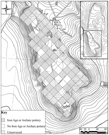
The methodology of the field survey has been designed both to measure carefully the expected densities of occupation in each area and to take account of the variation in the ground cover due to modern landholding patterns. Survey practitioners will note the influence of a number of Greek and other Mediterranean survey projects on the methodology in the following discussion.Footnote 3 Within the archaeological site's fence the density of habitation and other activities can be expected to be high; thus, the intra-site surface survey undertaken here has been designed to obtain precise spatial control over the information recovered. The intra-site surface survey has employed the same 30 m × 30 m grid implemented for geophysical survey here, facilitating connections between surface artefacts and subsurface anomalies. A combination of random samples (involving total collection) and grab samples (consisting only of diagnostic artefacts such as special finds or ceramics with rims, handles, bases or with recognisable fabric or surface treatment) has been used. The random sample is located in the area of the grid square with the best visibility. The aim is to produce an accurate count of the density of artefacts within a 90 m2 (10%) portion of the grid square. The remaining portion of the grid square has been covered with a grab collection, providing information about the chronology and function of this area, which the 90 m2 sample might not. Gridded collection of the South Hill took place in 2016. A similar study is planned on the North Hill in 2017 and 2018.
Suburban fieldwalking in the immediate hinterland of Olynthos allows comparison between the city centre and its countryside. Although the Study Area is not large, the opportunity to distinguish clearly how and where the density of artefacts changes as one moves away from the city is of considerable interest.Footnote 4 Walking has followed the boundaries of the modern fields. Walkers were spaced at 10 m intervals, collecting materials within a notional 2 m-wide corridor stretching across each field so that teams have scanned 20% of the ground surface in any given field. All artefacts have been collected. The aim of collection has been to gather a representative sample of the material observed on the surface. Walkers have been told to make ‘continuous forward progress’ across the field. The result, therefore, is a large random sample of what lies on the surface of each field, but not precisely a total collection (since in fields with the highest densities such a process would be too time consuming). A grab methodology is used for any highly diagnostic artefact encountered in the 80% of the field that is not part of the transect sample. To date, this grab collection has been used rarely, in 20 of 792 fields (2.5%). Fields within 500 m of the fence surrounding the archaeological site are limited to c.2000 m2 (generally 40 m × 50 m): this is to ensure precision in the measuring of artefact distributions. Beyond 500 m from the fenced area, survey fields are generally no larger than c.4000 m2 (80 m × 50 m or 40 m × 100 m).
Specialist studies
Finds processing and analysis (DLS)
The finds processing system has been designed to assist the Olynthos Project's contextual approach to studying the town and its immediate hinterland. Recovered artefacts and ecofacts have been considered, insofar as possible, as contextual assemblages rather than as categories of finds. Due to the nature of specialist analyses, which tend to divorce these items from their contexts, both during processing on site, and in archaeological publications, such a system is not necessarily the most common and is therefore described briefly here. Two stages have enabled data about material to be gathered initially by context, then sent for further analysis by experts in specific aspects of material culture, where further data can be obtained.Footnote 5
During Processing Stage One, the ceramic material has been sorted into the following categories (counting separate totals for rim, base, handle, wall, and unidentified sherds in each case): fine ware; medium ware; coarse ware; amphora; pithos; lamp; unidentified. In addition, the following categories of archaeological material have also been documented individually: tile; terracotta; plaster; chipped stone; millstone; pebble mosaic; coin; metal; bone; shell; glass; industrial waste; other. The rationale for sorting material in this way is that the Project is trying to reconstruct the total number of vessels represented by the sherds of each context, since the analysis of the total pottery assemblage will be conducted in terms of vessel types. The amount of material selected from each context should thus be the minimum which is necessary to represent all the types present in the context, but at the same time the maximum which is possible to represent each type. This is why the Project emphasises diagnostic elements (rims, bases and handles).
Processing Stage One can be thought of as a method of distillation in which highly diagnostic materials containing much information are selected and passed on to Processing Stage Two, and less diagnostic materials with minimal information are set aside after that information has been recorded. During Stage Two, finds specialists have brought their expertise to bear upon artefacts. Sorting carried out in Stage One has been checked, classifications of vessel shapes made, additional observations recorded, and material designated for drawing and photography.
Faunal analysis (SMS)
Most of the unburnt animal bones and fragments have been recovered by hand during excavation. There are also sometimes small, burnt items. Tiny fragments of bone have also been recovered during flotation. The identification of species can be made with confidence, since many of the items are substantially intact, common and distinctive. Standard references have been followed for measurements (Driesch Reference Driesch1976), tooth eruption wear stages (Grant Reference Grant, Wilson, Grigson and Payne1982), tooth eruption ages (Silver Reference Silver, Brothwell and Higgs1969) and pig tooth ageing (Wright et al. Reference Wright, Viner-Daniels, Parker Pearson and Umberto Albarella2014).
Soil micromorphology and geochemistry (ST)
Samples have been taken for thin-section micromorphology using the methodology of Murphy (Reference Murphy1986), and described using the accepted terminology of Bullock et al. (Reference Bullock, Fedoroff, Jongerius, Stoops and Tursina1985) and Stoops (Reference Stoops2003). Geochemical analysis has also been performed using the ICP-AES multi-element technique, which determines 34 elements (such as barium, calcium, iron, phosphate and various heavy metals).
Flotation and micro-debris analysis (LCN, ES)Footnote 6
Beneath the plough zone, at least one 10-litre soil sample has been taken from each context. Where a large context seems particularly rich, more than one sample has been taken from a restricted area. A flotation machine has been used with flot samples gathered in a sheer mesh of size 0.250 mm, while heavy residues have been retained in a 1 mm mesh. The dried heavy residues have been subjected to micro-debris analysis to recover both tiny items such as beads, and also fragments of larger ones such as bones or pottery sherds. These items have accumulated over time in fills and on archaeologically recovered surfaces (Rainville Reference Rainville2005); their quantification allows the density of material from different spaces to be compared. The heavy residues have been separated through screens of 6.3 mm, 4.75 mm, 2 mm and 1 mm. They have then been sorted to separate pottery fragments, bone, chipped stone, plaster, shell, charcoal, etc. Further sorting has been done to determine, as far as possible, the finer categories to which individual pieces belong (types of pottery, biological taxa, etc.). The density of the material belonging to the different categories has been calculated both by weight and by number of pieces.
Three-dimensional mapping using unmanned aerial vehicles (JM, DZ)
During the course of fieldwork it became clear that a more accurate understanding of the site and Study Area was required. Not only had there been significant landscape change since Robinson's plan was created (the course of the Olynthios river has changed somewhat), but also there are some trenches which he did not include, and some areas where his plans are somewhat inaccurate (for example, in the north-east area of the South Hill). It was therefore decided to re-survey the site using an unmanned aerial vehicle (UAV or drone). A DJI Phantom 3 Professional (P3P) quadcopter was deployed. Data were collected using the UAV in the form of optical imagery through still nadir photos (facing vertically towards the ground) following a regular grid pattern and maintaining 75% frontal overlap (with respect to the flight direction) and 60% side overlap (between flying tracks). Three different flight plans were executed. The North and South Hills and the surrounding study area were covered at varying flight altitudes in order to accomplish the desired spatial resolutions for each area.
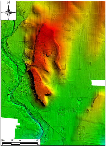
Structure from Motion (SfM) software was used to process the final sets of images and generate 3D Point Clouds for each of the three individual plans. The accurately adjusted and georeferenced 3D Point Clouds generated during the SfM processing were interpolated to produce the Digital Surface Models (DSMs) and the Orthophotos of the individual areas covered. DSMs were constructed representing the physical environment with elevation information for each pixel, including vegetation and structural elements. A pixel size of less than 10 cm has been achieved. A contour map with elevation steps of 20 cm has also been generated from a bare-earth digital elevation model (DEM) (Fig. 3). The DEM was interpolated from the 3D Point Cloud after classifying different quality elements (vegetation, structures, hard surfaces, dirt, etc.) and removing those (such as vegetation and buildings) that introduce elevation differences other than terrain relief. Total error for all flights was less than 10 cm.
Digital elevation model (DEM) of the site and surroundings of Olynthos, generated from drone orthophotography (JM).

Digital data and geographic information systems (DLS, HP)
A key to using these disparate types of data to build a coherent picture is the ability to encompass them all within a single system which facilitates their interrogation at multiple levels. The Project has collected both physical and digital data, with the type of data depending on the specific circumstances of data collection and the most appropriate equipment for any given task. Physical data, collected using paper forms and excavation drawings, have been digitised for collation and integration with digitally collected data, in preparation for digital analysis and future archiving. Information from the field survey, excavation, ceramic processing, micro-debris analysis and other aspects of the Project are all contained in FileMaker database files. Each FileMaker file consists essentially of unique lists of items identified by the Project, but may be linked to other files through the principle of relational databases. These data have been shared with geographic information science (GIS) applications in order to present spatial distributions of the Project's results.
Spatial data including maps, satellite imagery, aerial photography, excavation plans, drone imagery and geophysical plots are stored within GIS software, where they can be related to data incorporated from FileMaker and other software. The Olynthos Project utilises ArcGIS for its spatial mapping. Most of the data have been imported to ArcGIS from the software programs in which the data were originally created. This allows spatial data produced by different types of software to be collated and investigated in a single GIS program. Once incorporated into the GIS software, spatial data have been analysed, displayed and exported as images for publication.
OLYNTHOS AS A DYNAMIC COMMUNITY: SOME PRELIMINARY INDICATIONS
How are the data collected using these different methodologies contributing to a detailed picture of the city, which will enable us to address the kinds of question raised above? In this section we explore the sorts of information that are beginning to emerge, and look at some of the ways in which they are being fitted together to offer a multi-dimensional, multi-scalar model of Olynthos. Our discussion is organised according to the city's different districts, in each case drawing on a range of the analyses carried out so far. Although work is ongoing, we suggest that these preliminary results already attest to the value of our approach.
The North Hill
Geophysical survey (TJH, DLS)
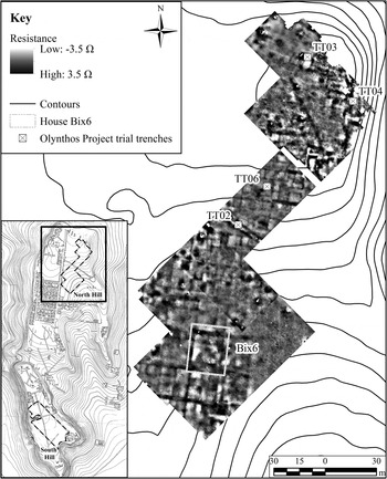
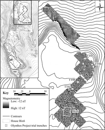
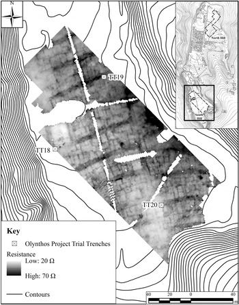
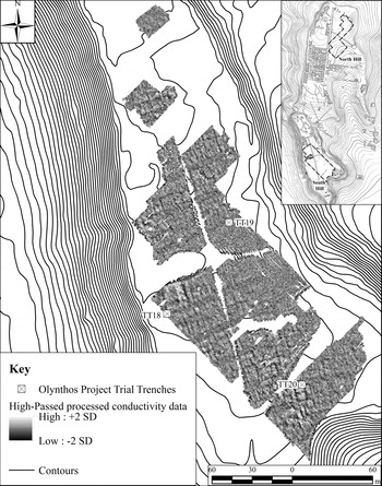
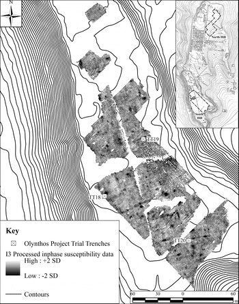
The north-east quadrant of the North Hill was selected for study because it offered an opportunity to determine whether the city grid identified by Robinson continued northwards, and to identify a house for excavation that was comparable to those he investigated. The area covered by geophysical survey in 2014 extends at two points as far as ‘Avenue B’: south-east of Block A viii, and approximately one block north of street ix (Figs. 4 and 5). This provides the Project with a clear link to identifiable features belonging to the Robinson ground plan. At the same time, earlier excavations had left this neighbourhood comparatively unexplored, with the exception of a long narrow trench, a small U-shaped trench, and several cuts across the edge of the hill where a search for urban defences had been conducted. Thus, it offered an excellent chance to gain new knowledge about the city.
North Hill twin-probe earth resistance data, after the application of a high pass filter and interpolation, shown overlaid upon the Olynthos Project contour map created from drone orthophotography (TJH, JM, HP).

North Hill magnetometer results after sensor destriping and interpolation, shown overlaid upon the Olynthos Project contour map created from drone orthophotography (TJH, JM, HP).

The geophysical survey of the North Hill in 2014 included 21 magnetometry grid squares (1.89 ha) and 15 earth resistance squares (1.35 ha). Despite lacunae in several squares due to dense vegetation cover, both techniques successfully detected a regular grid pattern of streets and blocks of houses, continuing the layout found in Robinson's main excavation area. In general, however, the resistance results provide a much clearer picture of structural elements (Fig. 4). Approximately 17 houses appear to be preserved in almost complete fashion in the resistance results. Another 15 houses appear in partial fashion around the edges of the area surveyed. Many high-resistance anomalies can be interpreted as individual walls, and compacted floor layers are suggested by distinct contrasts in the measurements obtained within buildings. Most houses appear to be units of c.290 m2 with the traditional courtyard and pastas arrangement characteristic of the domestic structures excavated by Robinson on the North Hill. One example, B x 5 and B x 6, may be twice as large, possibly combining two houses joined across the stenopos (rear alleyway). It is difficult to reach a firm conclusion without excavation, but such a union would not be unprecedented, as A v 6 and A v 8 were united at some point during their occupation.
In the northern part of the survey area, close to the edge of the hill, the regular grid pattern appears to end in Block B xii. It seems that only the southern half of this block was built. To the north, in the 50 m or so between houses B xii 8 or B xii 10 and the north-eastern corner of the North Hill, there lay an open zone with only a few detectable features. On the edge of this zone Robinson looked for defensive perimeter walls. A fortification wall is visible as a dark high-resistance line close to the edge of the hill, with Robinson's trenches (white, low resistance features) cross-cutting it. (The wall was also investigated in the Olynthos Project's trench [TT]04 – see below.) The largest feature within the open zone is possibly a second perimeter wall, stretching for 50 m at an angle of roughly 70 degrees, that is also indicated by a dark high-resistance line. A series of small walls also may be identified within the open zone, but their alignments are not as regular as those on the grid plan. Some of these walls were investigated in TT03.
The magnetometer provided results that complemented, but frequently did not duplicate, the resistance data (Fig. 5): this is because magnetic signals very likely corresponded not to walls but to dense deposits of collapsed or abandoned ceramic materials (tile, pottery) between walls. The most intense magnetic signals are consistent with those produced by the remains of kilns, furnaces and large, intact storage jars (pithoi). Two of these signals are visible in the open area at the north end of the North Hill; they are dark oval features ringed by a white halo. Magnetic signals also clearly indicated roads and stenopoi (alleys) in the southern region of the geophysical survey zone. The magnetic features appear as a grid, or tic-tac-toe board. They may be caused by the use of broken ceramic materials as fill in the makeup of road surfaces or alleyways between houses. The collapse of tile roofs into these spaces is a phenomenon noted in the excavation of house B ix 6 (see below).
One area where the geophysical responses are seen to vary is on the eastern side of the southernmost area of the survey. As work proceeded here it was noted that there were significantly more rocks in the topsoil than had been encountered elsewhere, and this made collecting resistance data quite difficult. The magnetometer data also reveal fewer anomalies in this area, although the pattern of roads is still visible in both magnetometer and resistance results. The results of the 1.0 m resistance data suggest that the shallow layers are more disturbed in this area; however, the reasons for this are not clear at this stage.Footnote 7
To the north of the North Hill, where only magnetometry was conducted, the results are dominated by negative responses due to the recent irrigation channels cut in advance of new tree planting. Broader underlying variations are likely to be associated with geological variations, but few anomalies of archaeological origin are visible. A cluster of discrete positive responses towards the eastern end of this area may indicate a small number of intact sub-plough zone anthropogenic features, but nothing like the density of occupation on top of the hill is represented in the data. An intriguing linear negative response is visible immediately to the north of the northern tip of the hill. It is possible that this is natural, perhaps due to more shallow bedrock in this area; however, an anthropogenic origin cannot be ruled out. Such a negative anomaly could indicate the looser fill of a trench, perhaps an unreported excavation, or the presence of different soil material brought in, possibly to make a ramp.
Testing the Geophysical Results: Trial Trenches TT02, TT03, TT04 and TT06 (ZHA)
Six trial trenches were opened in order to verify anomalies identified in the geophysical survey and to explore selected areas in more detail. Two (TT01, TT05) were opened in the south-western and northern parts of one house (B ix 6, described further below). The remaining four were intended to explore other significant anomalies.
Trial Trench TT02
Trenches from the 1930s show up in the geophysical survey as distinct and strongly marked features. TT02 was located to investigate one of these features, identifiable as a very clear diagonal trench on the north-east side of the North Hill, on the plan published in 1946 (Robinson Reference Robinson1946, pl. 272). Robinson's trench runs from Avenue B to the eastern edge of the North Hill. His principal aim seems to have been to confirm the existence of walls and roads that corresponded to the grid pattern that he had identified on the north-west side of the hill. The trench itself is poorly documented: since Robinson's discussion focuses on identifiable structures and roads, he does not describe trenches as such (Robinson Reference Robinson1946). It is unclear, therefore, what the original width and depth of this diagonal trench was, and its dimensions could not readily be specified after the 2014 excavations either, except in approximate terms. It was left open after the conclusion of Robinson's excavations, and the sides gradually eroded.
In 2014 a 5 m × 3 m rectangular trench was laid across the two banks and ditch of Robinson's trench, approximately north-north-west to south-south-east. It was intended to reveal more precisely what his team had discovered, identifying both disturbed and undisturbed deposits, and documenting the stratigraphy. Only the eastern half was dug. This was excavated as fully as possible, rather than just cleaning the cut of the trench, because of the rather sharp angle of the slope, and the apparent extent of erosion. This was also thought to offer the best chance of understanding the nature and chronology of the stratigraphy.
Excavation of TT02 successfully identified the profile of a trench and the scope of activities by the Robinson team in the 1930s. The orientation of the wall foundations confirms the existence of probable residential structures on the same alignment as in other identified sectors of the North Hill. The recovery of a terracotta relief shows that in the 1930s the exploration of anthropogenic evidence in this trench was partial only, an evaluation that is also confirmed by the discovery of undisturbed deposits at the lowest level investigated in 2014. These undisturbed levels have been backfilled to protect against erosion.
Trial Trench TT03
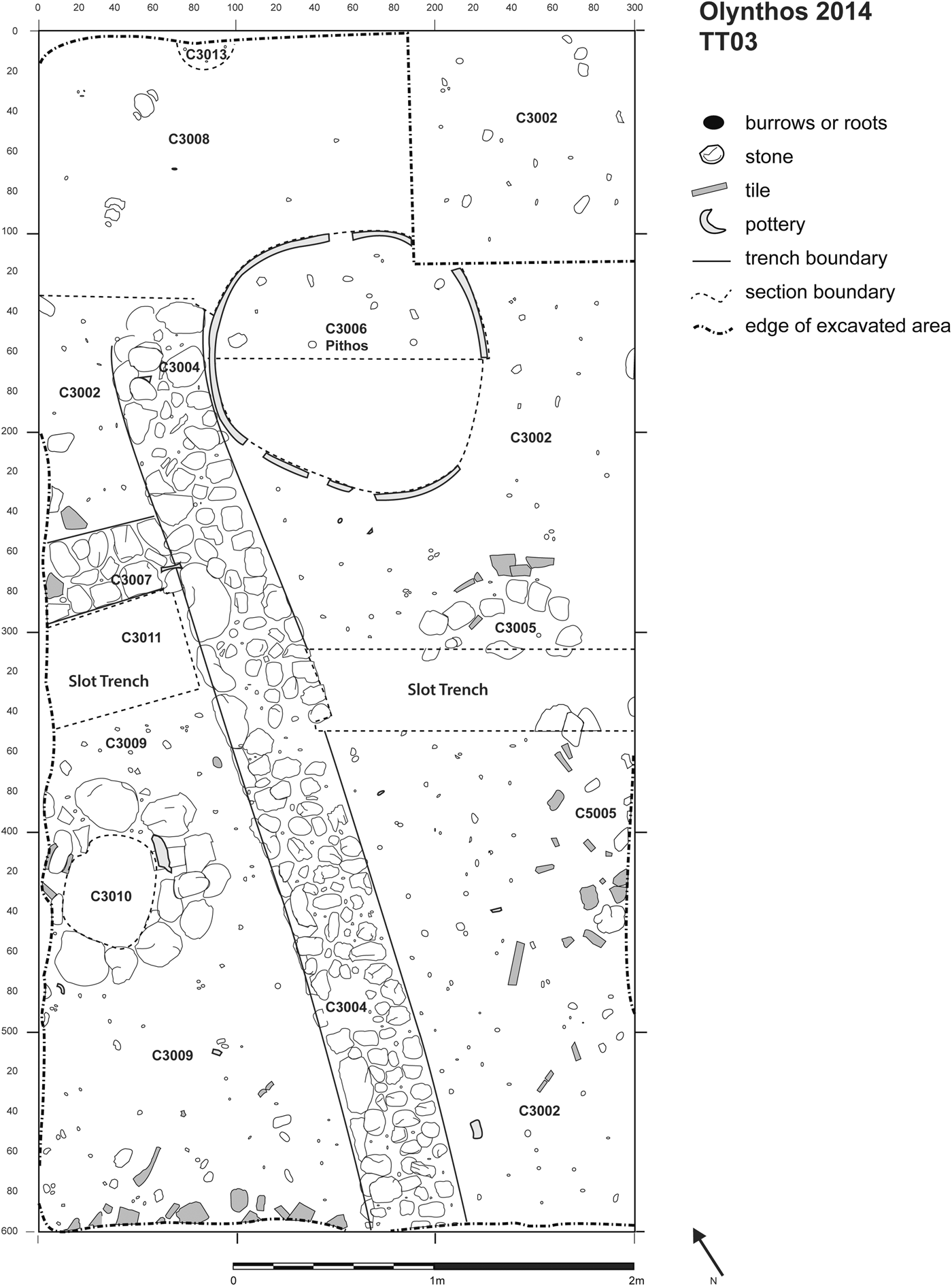
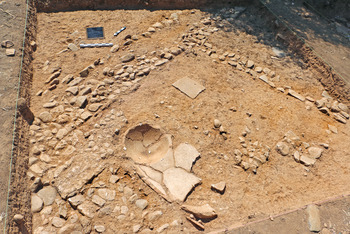
TT03 was located near the north-eastern perimeter fence of the North Hill, over a significant circular, or subcircular, anomaly identified by the magnetometer survey. At 3 m × 6 m, it was the largest trench excavated in 2014 (Fig. 6). The magnetic anomaly was identified as an unusually large pithos, which was filled with gravel as well as the partially collapsed upper body of the vessel (in the excavated half). At a minimum depth of 1.12 m and 1.50 m in diameter, the vessel corresponds to the larger of the two categories of storage container previously identified at Olynthos, whose capacity can be expected to exceed 1000 litres (Cahill Reference Cahill2002, 227). The vessel lies in a space defined by walls C3004 and C3008. Whether the pithos was also located within an interior, or in an exterior location has not yet been determined.
Plan of TT03 (David Smith, Steven O'Brien and Lorene Sterner).

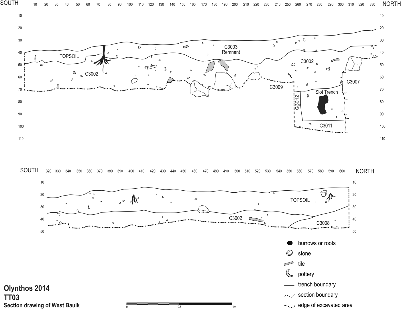
The earliest feature identified within TT03 was an east–west-oriented wall, C3007. Surviving to a depth of over 0.70 m (7–8 courses), C3007 appears to be a dry-stone construction, built of medium and large stones, with carefully laid faces and a fill of perpendicular, smaller stones, between them. A 0.5 m-wide slot trench was inserted east–west against the southern face of C3007 (Fig. 7), but the base of the wall was not reached; and so there is, as yet, no firm evidence by which to date its construction. No cut for the wall was identified. At a later stage, wall C3004 was laid on a roughly north–south alignment, apparently above wall C3007. The construction of wall C3004 is much cruder than that of C3007. Built of a very large variety of unworked stones, and including at least one substantial piece of the local conglomerate, which forms the underlying geology of the North and South Hills, wall C3004 has been traced to a maximum of 2–3 courses along much of its length. Where the slot trench through C3009 has afforded a better picture of the western elevation, the wall appears to be founded on a deposit of mortar, which has been traced to the base of the slot and the lowest course of wall C3007. Although they cannot be dated precisely, the stratigraphic relationship and differing alignments of walls C3007 and C3004 suggest that they represent two separate phases of construction in this area. This is important, since Robinson tended to assume that construction on the North Hill resulted from a single phase of activity, and although some indications to the contrary can be found in his data (e.g. Nevett Reference Nevett, Nevett and Whitleyforthcoming), they are difficult to demonstrate conclusively as they are not well documented.
Section of the western baulk of TT03 showing the slot trench against the face of C3007 (Uxue Rambla Eguilaz and Lorene Sterner).

The most intriguing feature inside the trench was a stone construction, C3010, which concealed, under a layer of stones and tile, two inverted clay vessels and a bronze bowl-like vessel, identified after conservation as a lamp. A broad, deep mortar on a concave base, crudely pierced in the centre, was inverted over a stamnoid pot, with most of its lower half still in situ, also inverted. The bronze lamp lay directly beneath the second vessel. Lower down, a pyramidal loomweight was located, under a pithos rim fragment, and another wall sherd. The superposition of multiple vessels, and the pierced base of the uppermost one (perhaps used for pouring libations), raise the possibility of a ritual purpose for the construction. This is not contradicted by the other finds within the space between the two walls, namely the sherds of fine tableware, and five loomweights in all. The association of an exceptionally large pithos and a structure containing a deposit with a possible ritual significance may perhaps suggest the presence of a sanctuary, or a sacred area. The size of the pithos suggests that it could have served a public purpose.
Trial Trench TT04
TT04 (6 m [E–W] × 3 m [N–S]) was positioned over a distinct linear feature, broader than the majority of the linear anomalies identified in the resistance survey conducted during March 2014, interrupted by a perpendicular intervention. Given the position of the dark feature, along the edge of the North Hill, and overlooking the fields to the east of the site, our hypothesis was that this might represent the remains of the ancient fortification wall. Robinson's team identified such a wall along the west side of the North Hill (where the rear walls of houses in Row A were strengthened to provide support for a fortified superstructure in mud brick: Robinson and Graham Reference Robinson and Graham1938, 39–42; cf. Cahill Reference Cahill2002, 29 and nn. 5, 6). They did not find any traces of the same fortification on the east flank of the North Hill, however. The primary goals of excavating TT04 were to discover the linear feature and to test its interpretation.
Prior to excavation, the surface of the trench gave a gravelly impression, with a slight rise in the ground elevation detectable roughly along the line of the magnetic feature. This, combined with the absence of archaeological finds, a thick clay matrix, and the presence of a rubble and gravel foundation, all point to the feature having been a mud-brick wall. At some point, the wall ceased to be maintained, and eventually collapsed, with the heavier rubble and mud brick sliding to the west, and the lighter gravel and cobbles washing to the east, down the slope; it is the result of this collapse, rather than the original structure of the wall itself, which was excavated in 2014. A similar mud-brick superstructure, on a stone socle, was identified as a collapsed fortification at nearby Dikaia (Bilouka, Vasileiou and Graikos Reference Bilouka, Vasileiou and Graikos2000, 304).
Three questions remain concerning the presumed fortification wall (C4005): the date of its construction; the techniques applied to build it; and its original appearance and dimensions. No foundation level as such was identified, nor any cuts associated with the initial construction of the wall. Nor was there any evidence of in situ courses of stone.
Trial Trench TT06
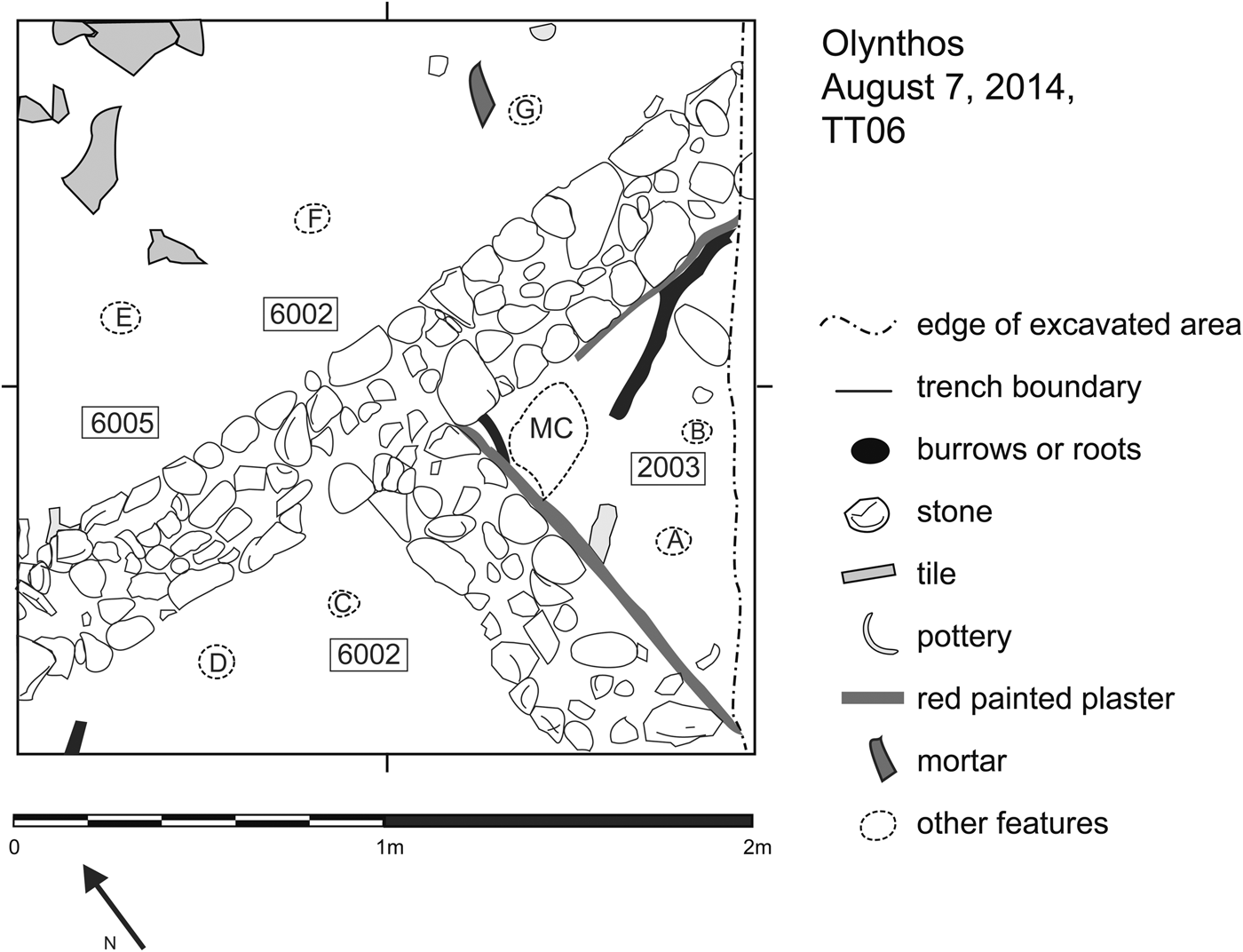
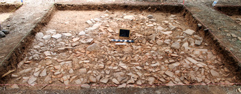
This trench, measuring 2 m × 2 m (Fig. 8), was partially excavated in 2014 in order to identify and characterise some linear features in the resistance survey that appeared to be in the northern part of a residential structure, corresponding to the north–south boundary wall between two rooms. It was started in the final week of excavation in 2014, in order to elicit comparative evidence for the excavation of a complete house. The trench was not therefore excavated down to in situ natural subsoil or bedrock. The sequence of deposits in this trench is thus only a partial one. Excavation confirmed the existence of at least one plastered room belonging to a presumed residential structure whose overall orientation shows the continuation of housing in regular insulae beyond the conserved area. The plaster rendering was renewed more than once during the lifetime of the space.
Plan of TT06 (Joseph Skinner and Lorene Sterner).

Summary
Several important points emerge from these trial trenches: first, they demonstrate conclusively that there is a consistent relationship between the geophysical results (both magnetic and earth resistance) and the nature of the subsurface remains. Secondly, they reveal the character of some of the deposits which were not well documented by Robinson, including the construction of the city wall. Thirdly, they enable us to evaluate better some of Robinson's strategies and assumptions, facilitating integration between Olynthos Project data and legacy data.
Excavation in house B ix 6 (LCN with BAA, KML, ES, SMS and ST)
The geophysical survey and the excavation of trial trenches facilitated selection of a single building for detailed investigation. The criteria for the selection were that (according to the geophysical results, interpreted in the light of the trial trenches and legacy data) it should appear to be a house, and that it was laid out in a manner that seemed reasonably typical of those around it; that it should be relatively well preserved; and that it should be similar in layout to the houses excavated by Robinson, so that the detailed information collected about the use of space within would have the greatest chance of being relevant to understanding the legacy data. For this last reason it seemed desirable to select a house on the southern side of an insula, as these tend to be organised in a more standardised manner than those on the north. Following the excavation of the two trial trenches in 2014 in a building corresponding, using Robinson's numbering system, to B ix 6, this structure was selected for complete excavation. One of those trial trenches (TT05) yielded well-preserved destruction deposits, even though the stratigraphy was relatively shallow.
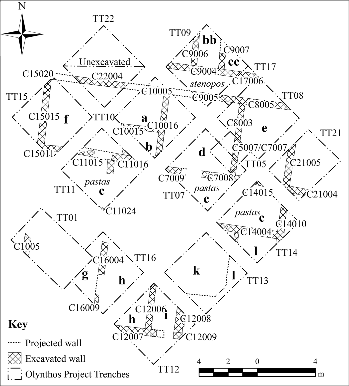
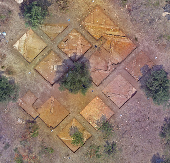
B ix 6, and the trenches in it, are still in the process of excavation (Fig. 9 and Fig. 10). The discussion below briefly summarises the state of our knowledge of the building following the July 2016 field season and demonstrates the way in which our approach is producing a fine-grained picture of various aspects of the house as a structure and as a socio-economic unit. Since in most instances only the most recent occupation phase has been reached, the discussion proceeds spatially rather than chronologically.
Schematic plan of the walls, spaces and selected contexts in house B ix 6. Room numbers referred to in the text are shown in bold lower-case letters. Numbers prefaced by ‘TT’ indicate Olynthos Project trenches (Filippos Stefanou and HP).

Orthophotograph of house B ix 6. Wall socles, courtyard, stenopos and other features are visible as stone cobbles within the square excavation trenches (Filippos Stefanou).

In excavating B ix 6 our intention has been to study the patterns of domestic activity in and around the building, combining a variety of independent lines of evidence to reconstruct them in as much detail as possible. Questions we aim to address include: what foodstuffs and consumer goods were available to the occupants, and from which sources were they obtained? How and where were different domestic tasks performed? What uses were made of upper-storey space (which has rarely been identified and studied in Greek contexts)? How much did the use of space change over time, and in what ways? To what extent can the activities of different groups (such as men, women or children) can be detected through the archaeological evidence? A first step towards addressing these questions is to achieve an integrated picture of the different components of the archaeological record in each part of the structure, looking at architecture alongside artefacts, ecofacts and the results of scientific analysis. For this reason, rather than discussing the different specialist studies separately, an attempt is made below to bring together these different strands of evidence, albeit in a preliminary and summary form.
In general the soil cover in this part of the site is shallow, ranging from about 20 cm in depth over TT05 and TT11, to about 40 cm in the northern part of TT09 (see Fig. 9 for the layout of the trenches). At various times in its recent history the North Hill has been used for agricultural purposes: for example, Robinson (Reference Robinson1930, xi) reports ploughing in the early twentieth century, and this may have continued following his project, as the site reverted to agricultural use before eventually becoming the property of the Greek State. The topsoil above the house has been disturbed by ploughing to about 20 cm and in places (for example TT05 and TT11) the stone socles show signs of what might be plough damage in the form of scratches across the upper surfaces of the stones. Within the plough zone displaced cobbles were found together with fragments of tile and pottery which had been fragmented and moved about. Nevertheless, below this layer, the archaeological deposits were surprisingly well preserved, given the shallow soil cover.
Specialist studies of various samples including flots, phytoliths and starches, together with additional geochemical and micromorphology samples are still in progress. Some preliminary comments can tentatively be made about the house as a whole based on the preliminary findings of the micro-debris study, which is also ongoing. Snail shells are common and are evidence of bioturbation throughout the site. Pottery and plaster are, likewise, ubiquitous. What is more surprising is the scarcity of certain types of find despite a careful screening for them. There is relatively little bone, probably because of the acidity of the soil. (As noted below, the bones that have been recovered have almost all come from ashy deposits, where the pH of the soil has been altered.) Coins are similarly rare, with only one recovered from the samples so far.
The first two trenches excavated in the house were small test trenches dug in 2014 to investigate specific features. The strategy adopted subsequently has been to divide the building into a series of squares measuring 5 m × 5 m, following the orientation of the 30 m grid originally set out for the geophysical survey. This means that the trenches are at an angle of 45 degrees to the walls of the house, avoiding the possibility that walls may be hidden until the final stages of excavation. Trenches measuring 4 m × 4 m have been laid out leaving 1 m baulks between to provide sections for micromorphology sampling and to ensure good stratigraphic control. (These will eventually be removed when final samples have been taken.)
TT01 measures 5 m × 3 m. It was laid out over the western wall of the house in order to test the identification of that wall in the geophysical results and to investigate patches of low and high resistance on either side. Work was concentrated in the western and southern areas. The boundary wall of the house was located, as expected, in the western corner, its socle of cobbles (C1005) surviving to at least five courses. The top began to emerge at a depth of about 15 cm below the surface of the topsoil. West of the wall, in the corner of the trench, a cobbled surface (C1012), of which only a small part is exposed, belongs to the neighbouring house, B ix 4, and explains the high-resistance anomaly here. The top of that surface is at the same height as the top of C1005. These features were the only architecture located in the trench. On both sides of the wall the fill contained broken tile and sherds. Inside B ix 6 a series of contexts is likely to represent mud-brick collapse.
The floor level of this house lies well below the cobbled surface in its neighbour. A layer of pebbles and gravel (C1010) was encountered at a depth of about 60 cm in the south corner of the trench, with an edge running parallel to the line of C1005. Based on micromorphological analysis, C1010 seems to have been a metalled outdoor surface composed of sand and gravel with some weathered sherds. Other micromorphology samples revealed a lens of white lime plaster which had been applied to the inside wall surface and extended horizontally to form a plaster floor 1–2 cm thick, which lacked the fine finish found on the red plaster floor in TT06. The preservation was variable, but in those samples from nearest the wall it was excellent.
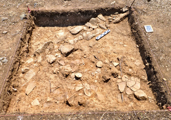
TT05 is a square measuring 2 m × 2 m which was laid out across an anomaly interpreted as a north–south interior wall dividing two rooms in the northern part of the house. The top surface of the socle for such a wall (C5007) was encountered immediately below the topsoil at a depth of 10–15 cm. It is composed of stone cobbles and had some plaster adhering to its west face at the northern end. No features or floor level were reached on the eastern side of the wall, although some pottery and a bronze coin were recovered from this area. On the western side of the wall, underlying a thick layer of collapsed tile, a lens was located which may perhaps represent some kind of surface (C5004), although it is not found consistently (Fig. 11). This consisted of a patchy, thin film of clay overlain by large amounts (3.7 kg) of fragmentary pottery which was clustered into somewhat discrete (though in some cases overlapping) groups, varying in density. Many of the vessels followed similar orientations, tilting towards the north and west, suggesting that they may have fallen, either from a shelf or (perhaps) from an upper storey. Although they are in fragmentary condition, a large number are at least partially reconstructable; they include both fine-ware (especially skyphoi and other cups) and medium-ware forms (mostly jugs and basins). This context, with its associated deposit of pottery, continued into the baulks on the north-west and south-west sides of the trench, where it was detected in neighbouring trenches in subsequent years, as discussed below.
Photograph of TT05 during excavation (Kate Larson).

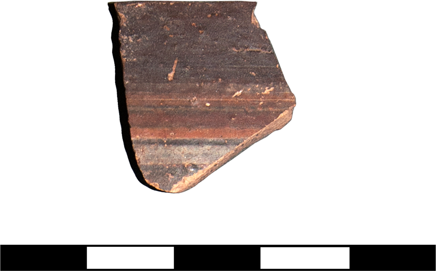
Five additional trenches, laid out in 2015, explored the northern range of rooms further. TT07 extended TT05 to the south-west. The north–south boundary wall between spaces continued in this trench as C7007. The clusters of vessels noted in TT05 to the west of this feature continued westwards and southwards in TT07 as C7004, away from the wall first identified in 2014. This deposit yielded a significant number of fine- and medium-ware vessels which appear to have been crushed during the collapse of the building. They include a fine lekythos with an unusual profile (C7004PT01: Fig. 12, discussed below under ‘Ceramics’) and fragments from at least eight different medium-ware vessels. These were identified as resting on a surface consisting of a compact deposit of yellow/brown/grey clay with small pebbles (C7015). The space in which this material was found, (d), was delimited to its south by the stone socle for a wall running east–west (C7008), which formed part of the north wall of the pastas of the house (c). South of this wall there were fewer ceramics than in room (d), and the vessels were less complete. Nevertheless, a range of vessels was found here, including the handles for two lekanis lids. Again, these appeared to rest on a surface (C7014) comparable to that identified in (d).
C7004PT01: lekythos with an unusual profile (scale in cm) (Irene Liesk).

TT08 lies north-east of TT07. Most of the trench is occupied by parts of two spaces continuing from TT07 (d) and (e), separated by a continuation of the north–south dividing wall (C5007/C7007), which is here identified as C8003. In the north-western part of the trench this meets a substantial wall running east–west, C8005, which constitutes the rear wall of the house. Beyond is a section of the stenopos, the rear alley. The fills in both (d) and (e) contained fragments of tile and of white and red plaster. Tile and ceramic fragments seem to have been deposited in two distinct layers within the fill. Finds in (d) include fragments of a Corinthian-type skyphos (C8004PT01).
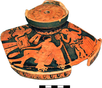
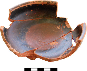
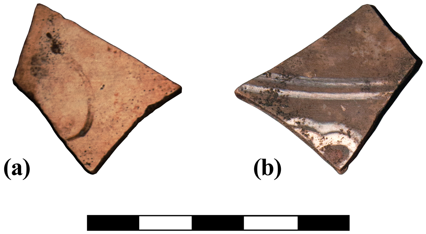
In (e) a layer of small stones (C8010) was located at about 25 cm below the surface. This spanned the entire exposed extent of the space, and is assumed to represent either a floor or a subfloor. This interpretation is supported by the fact that, once exposed, both faces of wall C8003 were seen to preserve significant amounts of white plaster which ceases at the level of C8010. A number of artefacts also seemed to rest at this level, including 4 kg of medium ware comprising rims of chytrai, a hydria rim and parts of other closed vessels. It was therefore sampled on a 50 cm grid for phytoliths, starch and ICP analysis (results of which are still pending). Ceramic finds from a level above this one (C8007) included medium wares as well as fragments of black-slipped vessels. Among these were body fragments and a red-figure lid decorated with Dionysos and maenads from a lekanis (C8007PT01: Fig. 13), the knob of which was found in TT07 (C7006), suggesting that the vessel may have been located in an upper storey at the time the house collapsed. C8007 may therefore represent upper-storey collapse. Removal of C8010 over a limited area revealed a second layer about 15 cm below the first one which was similar to it but composed of larger, denser, stones (C8012).
C8007PT01: red-figure lekanis lid decorated with Dionysos and maenads (scale in cm) (Irene Liesk).

To the north of C8005, the stenopos behind the house had cobble paving (C8011). Along the two sides were narrow, raised platforms, also of cobbles (C8008 and C8009), which apparently do not bond either with the house walls or with the deeper cobbled surface of the stenopos itself. Sitting within the stenopos was a thick tile layer (C8006) beneath which lay some ceramic material including several body fragments of a beehive, resting on C8011.
TT09 lies to the north-west of TT08 and was located to investigate the stenopos and sample the southern part of the house to the north (house B ix 5). The fill in this trench was deeper than in any of the other trenches excavated so far (at its deepest, 40 cm in the northern corner of the trench). Beneath the topsoil and destruction fill, the continuation of the rear wall of house B ix 6 was located as C9005, along with the stenopos to its north and parts of three rooms of B ix 5. As in TT08, the stenopos contained a very thick layer of well-preserved (in some cases almost complete) tiles (more than 135 kg were removed from this area). Underneath was an almost complete transport amphora, as well as fragments of fine-ware vessels which may either represent refuse deposits, or alternatively may have fallen from the upper storey either of B ix 6 or B ix 5 as the two houses collapsed. This section of the stenopos lacked well-defined cobble surfaces either side of the central channel.
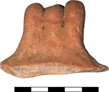
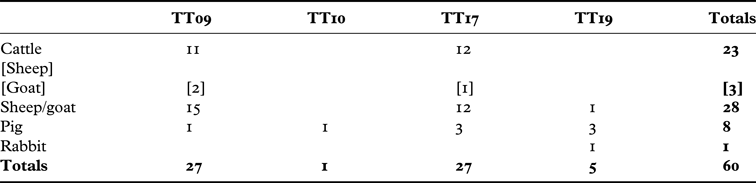
The stenopos is separated from the northern house, B ix 5, by the stone socle of the house's back wall (C9004). Excavations in this neighbouring property provide a valuable parallel for some of the finds from B ix 6. Work focused on the central and eastern spaces, (bb) and (cc). Space (bb) contained a variety of well-preserved ceramic vessels, including a small table amphora (C9012PT01: Fig. 14). Space (cc) was notable for its distinctive ashy deposit (C9013) containing broken ceramics and terracottas. These were found together with fragments of unburnt bone from cattle, pigs and sheep or goats, along with further burnt fragments of indeterminate species (see the section on faunal material, below, for a more detailed discussion). Interestingly, the cattle and pig bones show no sign of heat damage, and the cattle bones are likely to have been discarded during butchery. It therefore seems likely that processing, as well as cooking and consumption of meat, took place within the house. Based on these finds, (cc) seems to represent what Robinson and Graham termed the ‘flue’, and it provides a useful comparison for space (b) in B ix 6 (TT10 – discussed below). The material contained within seems to represent, at least in part, refuse.
C9012PT01: medium-ware table amphora (scale in cm) (Irene Liesk).

TT10 is located to the south-west of TT09. In the north corner of the trench the rear wall of the house continues east–west as C10005. On the east side of the trench three courses of cobble socle remain from a north–south wall (C10016) separating the western side of (d) from two other spaces (a) and (b). Excavation focused on the latter two spaces. In (a) the remains of a terracotta bathtub were located, the walls broken off just above the base, and incomplete on its south side (Fig. 15). The bath is set into a plaster or mortar surface adjacent to the rear wall of the house, to which it was connected by a thick cobble-and-mortar feature (C10009). This part of the house had a complex history which included at least one episode of significant remodelling, probably involving the rearrangement of the walls on the room's western side and the re-laying of a floor over a disused millstone. A small slot trench was cut adjacent to the bathtub in order to establish the underlying stratigraphy. It showed that a series of layers of waterproof plaster had been laid prior to the tub's installation and that the tub itself must have been placed here only during the last phase of use of this space.
C10018 showing the remains of the bathtub (foreground) and millstone (Marine Garcia).

Further to the south, part of space (b) was separated from (a) by a further wall socle (C10015). Space (b) contained ashy deposits similar to those located in space (cc) in TT09 and seems likely to have been a second flue, an interpretation supported by its location adjacent to the bathing area – an arrangement frequently found by Robinson. The deposits in (b) contained part of the unburnt jaw of a juvenile pig (probably slaughtered for meat), along with an extensive collection of pottery. Among the vessels present were a nearly complete lekythos with an unusual white-slipped interior (C10021PT01), a lamp of Howland type 25B (C1017PT01) and a one-handler with full profile (C10017PT02), along with several medium-ware vessels, some of which were for cooking. Given the unburnt state of the bone material found in both (b) and (cc), it seems likely that in each case the ‘flue’ was used for secondary discard of ash and other household refuse, and perhaps as an outlet for smoke from a hearth located elsewhere, rather than as a fireplace. In comparable spaces in the houses they excavated, Robinson and Graham (Reference Robinson and Graham1938, 189–97) identify examples of this practice as well as other cases where a fire was lit directly in the space itself.
TT11 lies to the south-west of TT10. The socle for an east–west wall (C11015) runs across the northern part of the trench, separating the pastas (c) from an interior room to its north. A section of the central and western part of the wall is missing before a fragmentary continuation of it is found in the western part of the trench (C11016). It is unclear whether there was originally a stretch of wall here which was destroyed, or whether this was a doorway. C11016 is clearly damaged, with stones missing, and C11015 is apparently twisted and buckled, its upper surface pointing southwards. Curiously, the face of the wall is slightly out of alignment with the face of what appears to be the continuation of the same wall, in TT07. The reason for this may become clearer when the intervening baulk is removed.
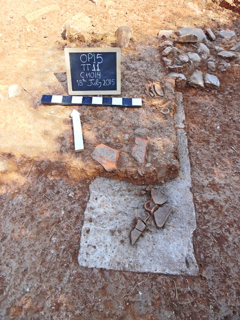
Excavation in TT11 focused on southern space (c), the pastas. Below the topsoil and a layer of tile collapse was found a large, well-dressed ashlar block which is possibly reused from an earlier structure. It was laid perpendicular to C11015 and probably served as the base for a set of wooden stairs leading to a balcony and rooms in an upper storey above. On top of this block, beneath a layer of tile, lay a collection of nearly complete, though smashed, ceramic vessels (Fig. 16). These included a handmade, miniature, unslipped, square tray (C11014PT04), a miniature salt cellar (C11014PT02), and at least seven black-slipped drinking vessels. An iron nail was also found among them. To the east, south and west of the block the tile layer continued at a lower level and further ceramic vessels were found beneath, including additional fragments of C11014PT04. These rested on a pebble layer which may represent a floor or subfloor, which was about 20 cm below the top of the upper surface of the stair base. The southern corner of TT11 grazed the face of the southern wall of the pastas (C11024), which is neatly built of small angular stones in a very different style from the typical cobble socles found elsewhere. Resting against its face was a small, unslipped jug (C11022PT01) which had lost its neck, rim and handle in antiquity, but was otherwise intact.
C11014: mid-excavation photograph showing the ashlar block with ceramic vessels emerging on top (Patrik Klingborg).

Although further cultural deposits remained in most of these trenches, new areas were opened in 2016 with the aim of exposing the most recent occupation levels over the whole of the house, before returning in a future season to the old trenches to address specific questions about earlier phases or about the house's construction. A further eight trenches were therefore laid out, improving our knowledge of the overall organisation of interior space and of the context of the house within the broader fabric of the block in which it is located.
TT12 sits over the southern boundary of the house, revealing part of the street to its south, together with a length of the socle belonging to the facade and the area just inside it. Excavation concentrated on the facade itself (C12007) and interior spaces behind. The western extent of this socle is faced with cut stone blocks (visible in Fig. 10 in the southernmost excavation square, to the left of the tree), including a long but relatively narrow threshold block which disappears into the south-western baulk. Running along the interior face and continuing eastwards inside the other blocks are two lines of unworked stone cobbles. It is unclear whether C12007 forms a continuous feature right across the trench, because the tree interrupting its course was not removed in 2016. Two further wall socles abut C12007, running north–south, and are roughly parallel. The westernmost of these, C12006, is faced at its southern end with a further two ashlar blocks and further north is composed solely of cobbles, with a few tile fragments also incorporated into it. It disappears into the baulk at the northern corner of the trench. This north–south wall separates a space (h) with a gravelly deposit probably representing a surface (C12023) to the west from a second space (i) which had a cobbled surface at the north end (C12019), but no discernible surface further to the south. The second socle, to the east (C12008), is more roughly built, consisting of larger cobbles which are today less precisely placed and lack any evidence of facing. All three of the socles in this trench preserved evidence of mortar between the stones.
A major question to be resolved in a future season is whether the threshold block marks the location of a doorway which was in use at the time the house was destroyed, or whether it was being reused as building material for the house facade. From the perspective of the plan, the internal space to the east of C12006 looks like an entrance, leading into a cobbled courtyard to the north (see discussion of TT13 below) and with cut blocks accenting the socle at the corner. It is possible that there were two entrances leading into different spaces, although in the houses excavated by Robinson, where there were two entrances one typically led into a space adjacent to the party wall.
TT13 lies to the north-east of TT12. No wall socles were found in this trench. Instead, the major feature was a cobbled surface (C13009) belonging to what must have been an unroofed courtyard (k), which surely represents a continuation of C12019. At the south and east corners of TT13, although there is apparently no dividing wall, there is a change of surface (an absence of cobbles), suggesting perhaps roofed but unwalled spaces (Fig. 10). In the southernmost part of the unpaved area a cut stone block (possibly a base playing some kind of structural role) lies at the boundary between the two surfaces, close to the south-western baulk. A deposit of at least 23 loomweights was also found here clustered closely together and disappearing into the baulk. Overlying the cobbles of (k) was a thick destruction deposit composed (in places) of as many as six layers of fallen roof tiles (7963 tile fragments were recovered, weighing over 602 kg). A total of 19 kg of smashed fine- and medium-ware pottery lay beneath (Fig. 17). In addition, 28.7 kg of amphora sherds, estimated to comprise at least 12 separate vessels, were recovered from here. The sheer quantity of roof tile suggests that as the house collapsed the pitched tiled roofs on the surrounding rooms slid down into the courtyard.
C13007 showing crushed ceramics overlying the cobbled surface of the courtyard (k) (Marine Garcia).

TT14 lies to the northeast of TT13. Most of the trench is occupied by the eastern end of the pastas (c). In the eastern corner of the trench a wall (C14010) perpendicular to the southern wall of the pastas represents the boundary between house B ix 6 and its eastern neighbour, B ix 8. Like the western boundary wall exposed in TT01, this seems to have been a retaining wall, although, to preserve its stability, only its top two courses were exposed on its eastern face, while soil was left in place below as excavation progressed deeper. At about 0.5 m below the preserved top of C14010, beneath a very thick layer of tile, a small area of a surface from house B ix 8 was exposed, consisting of clay and pebbles. Inside B ix 6, south of the southern wall of the pastas (C14004) and abutting against it, is an interesting structural feature in the form of what appears to be the stone setting for a wooden post which may have helped to stabilise or support the wall and the tiled roof above.
TT15, on the western side of B ix 6, provides additional evidence of its boundary with B ix 4, as well as revealing the western end of the northern range of rooms in B ix 6. C15015, the socle belonging to the north–south boundary wall between the two houses, came to light about 20 cm beneath the surface. In the western corner of the trench, a small area of house B ix 4 was exposed. Flecks of red plaster in the fill against the western face of C15015 suggested that it once had a red plaster surface. At about 10 cm below its upper surface a substantial floor came to light (C15012). This has a mortar surface with a neatly moulded curb, forming a border for a black and white pebble mosaic beyond, which appears not to have had any deliberate design (Fig. 10, visible at the north-western edge). This floor suggests the space may have been of the type identified by Robinson and Graham as an andron – a room associated in Athenian literary sources with use for the symposium. Its presence within the northern range of rooms of the house is unusual, but not unprecedented (compare house A v 8, where an andron occupies an identical position: Robinson and Graham Reference Robinson and Graham1938, 95–6). A fragment, probably from a bell krater, with a red-figure figurative design, was found in this space in B ix 4.
Abutting C15015 in the northern corner of the trench, a small part of the rear wall of the house came to light (C15020). In the southern corner of the trench, and also abutting C15015, the northern wall of the pastas was identified as C15011. The majority of TT15 is occupied by room (f), to the north of this wall, which, together with (a) and (b) detected in TT10, probably makes up a complex of a type referred to in the context of Robinson's excavation as the oikos unit (or ‘oecus unit’: Mylonas Reference Mylonas and Robinson1946). This group of rooms was interpreted as a living space which consisted of a main room, occasionally furnished with a stone-curbed hearth, and two smaller spaces, one apparently used for bathing and the other (the ‘flue’) containing ashes. In B ix 6, room (f) would equate with the larger living space, (a) and (b) with the bathing area and flue, respectively. A layer of small pebbles similar to those identified as floors or subfloors in TT07 and TT08 (C7015, C8010, C8012) was located here (C15013) and probably represents a floor level, although further cultural levels lie beneath it.
TT16 lies to the south of TT15. The trench is bisected north–south by the socles for two walls (C16004 and C16009) which are of different thicknesses and constructions, and follow slightly different alignments. Each has at least two courses and continues below the level excavated in 2016. Work concentrated on the west side of these walls, where a deposit (C16007) was located within which there were multiple ceramic vessels lying crushed in small pieces. These included sherds of amphora along with fine- and medium-ware vessels such as a large, coil-built tub or basin which was found partly resting on top of the wall socle. Further excavation will be necessary here to determine the relationship between this deposit and any floor level, which may lie beneath. Curiously, despite its proximity to TT01, no trace of this deposit was found in that trench, which was excavated to a deeper level.
Three further trenches, TT17, TT21 and TT22, have exposed more of the boundary walls of the house. TT17 removed part of the baulk between TT08 and TT09, revealing that the platforms on either side of the stenopos (C17007 and C17008) continued from TT08, before terminating in curved ends. These may have served to canalise the flow of water here, directing it to the centre of the channel. A half-preserved beehive lid recovered from the cobbled surface of the stenopos is composed of orange fabric. It originally measured some 0.7 m in diameter, with a maximum thickness of nearly 0.03 m, and was finished with two inscribed concentric circles near its central area. In TT21, on the eastern side of the northern range of rooms, only the western corner of the trench lies within house B ix 6, one corner of space (e). In contrast with the part of the space excavated in TT08, however, there was a notable absence of pottery here.
Summary: an interim assessment of the structure, organisation and destruction of house B ix 6
The work carried out so far in B ix 6 suggests that, like the houses previously excavated on Olynthos’ North Hill, this one was constructed with a stone socle composed mainly of cobbles. Often, larger stones were used for each face and smaller ones in the interior. Some of the walls included traces of a calcareous mortar or plaster between the stones. On the facade, a few cut blocks were placed prominently on the exterior face. The superstructure of the walls must have been composed of mud bricks, and although these have now almost entirely decomposed, they are probably identifiable as the source of a compact, reddish fill, containing occasional battered sherds, a few of which are datable to the late fifth century bc. Some of the walls were originally covered with a white, or, on occasion, red plaster, fragments of which are found scattered widely through the fill and in some cases (for example, the western face of C8003) are still adhering to the face of the socle.
B ix 6 was roofed with large terracotta tiles. Among them are examples of both flat ‘pan’ and curved ‘cover’ tiles, many of which bear edges, frequently thickened and upturned or otherwise demarcated. Both the thicknesses and the fabrics are variable (suggesting replacement of individual tiles and repair of roofs over time, utilising different batches of tiles), but that variation is limited to the extent that their identification as roof tiles is rarely in question. Black and red slip remains on many fragments, along with the occasional paw print of a passing dog or the whimsical design of fingertips drawn across the wet clay during the manufacturing process Supporting the weight of this tile roof may perhaps have been a challenge for the builders of the house: while, to date, no traces have been located of foundation trenches for the walls, evidence has been found for wooden posts in (i) and in the pastas, which must have reinforced the structure.
The evidence of wall abutments in TT14 suggests that when the house was originally constructed, at least some of the exterior walls were built first, and that the interior walls were then built up against them. The topography of this part of the North Hill must have been less flat than it appears today: both east and west party walls seem to have acted as retaining terrace walls, with the socle of that on the west side reaching five courses in TT01. Interestingly, however, it seems that the discrepancy in height between B ix 6 and its western neighbour B ix 4 may not have been so great further north, in TT15. Across the house as a whole, floor levels are not always easy to locate. While the courtyard was cobbled, most of the other rooms must have had floors of beaten earth, clay, or lime plaster. In rooms (d), (e) and (f) a pebble matrix may have been subfloor for a thinner layer of earth or clay. In (d), (e) and (h) the presence of floor levels can be inferred from layers of ceramics which rest at the same level across an expanse of several square metres. Micro-debris analysis suggests that the floors themselves are remarkably ‘clean’ of inclusions, as is, interestingly, the one sample from a context which may be a subfloor levelling fill. This pattern might reveal something about the settlement history of the site, with little evidence of cultural inclusions in the materials that were used to lay the floors.
The presence of the stair base in the pastas, together with the tile attesting to a pitched roof, indicates that there must once have been an upper storey over at least the northern part of the house. The fragments of the ceramic basin found on top of the wall socle dividing (g) and (h) in TT16 suggest that the vessel may have dropped from above as the building collapsed. A similar scenario is suggested by the lekanis lid C7006PT01 and associated knob which were located in two separate spaces, (c) and (e). At the same time, in some places – for example, spaces (g) and (e) – the ceramics rest at two successive levels, which may constitute the stratified remains of upper and lower storeys. This interpretation will be tested through further micromorphology in an effort to study the use of space in upper and lower storeys separately.
In relation to other aspects of the use of space, full analysis of the distribution of artefacts and ecofacts will be undertaken with the aid of the GIS once excavation is complete. But some preliminary, tentative remarks can already be made. From the perspective of the ceramics, after two seasons of excavation in 13 trenches on the North Hill (not including the ‘trial trenches’ of 2014), more than two metric tons of material has been recovered (2049 kg). This includes 1812.8 kg of roof tile, 9.1 kg of fine ware, 109 kg of medium ware, 4.4 kg of coarse ware, 73.9 kg of amphora, and 20 kg of pithos. Although the assemblage is highly fragmentary, there is a wide range of vessel forms represented and significant patterns in the distribution are emerging, with particularly dense concentrations of material in spaces (a), (b), (c) and (k). The majority of the complete fine-ware profiles are from the northern part of the house. From a preliminary perspective, one conclusion is emerging, namely that the Greek house was not necessarily a very tidy affair. Residual debris from several generations of ceramic usage, breakage, and clean-up, as well as post-depositional processes, make for a palimpsest of data. Micro-debris analysis supports this conclusion and also shows that cooking ware is denser in the pastas and especially the flue (b), while plaster is found especially in the pastas and (d). It is tempting to interpret the pastas and rooms to the north of it as foci of particularly intense activity, but further lines of evidence must be brought to bear before this can be confirmed. The concentration of ceramics in (b) may well represent rubbish disposal practices, rather than patterns of ceramic usage. At the same time, the presence of an upper storey over this northern range of rooms may have inflated the numbers of vessels found in this area, since material from upper and lower storeys will need to be distinguished to achieve an accurate measure of ceramic density here.
A question remaining to be resolved is the nature of the processes by which B ix 6 and its neighbours were destroyed. In common with the majority of the houses excavated by Robinson (Reference Robinson1946, vii), no sign of a burnt destruction has been located here. Rather, the building seems to have collapsed, covering the remaining contents with the building materials – a thick layer of tile and soil derived from the mud-brick superstructure. In many places the tiles lie immediately over the artefact assemblages, with the dissolved mud brick above. In the andron of B ix 4, red-painted wall plaster was found lying face up on the tile layer, suggesting that after the roof collapsed, plaster from the wall may have slid off the surface before the wall itself had completely disintegrated.
Future work in B ix 6 will involve not only the completion of its excavation but also a range of analytical tasks. Information from deposits appearing in more than one trench will be united. Scientific samples (flotation, phytolith, starch and geochemical as well as micromorphological) will continue to be taken and processed, alongside ceramic and artefact studies. The geographic information system will eventually enable their distributions to be mapped spatially, shedding light on how the space of the house was used and modified, and how the structure finally collapsed. The resulting model will be an unprecedentedly detailed study of spatial usage in a Classical house. At the same time, the model will provide a basis for methodological conclusions about (for example) the relative reliability of architecture, artefact distributions and various types of scientific sample as guides to domestic activity in Greece and elsewhere (see Nevett Reference Nevett and Müller2015).
Bridging Between Different Analytical Scales: The ceramic assemblage from the North Hill (BAA, KML, AP)
While the geophysical survey and trial trenches together offer a large-scale impression of the character and layout of a whole neighbourhood in the north-east part of the North Hill, the excavation of house B ix 6 offers a very detailed case study of the organisation of a single house and, ultimately, some of the activities taking place within. Bridging between such different analytical scales is a challenge: the use of the GIS enables the data to be nested and contained within a single system, but it does not provide a conceptual framework through which to link these very different analytical units. Such a link is provided, however, by artefacts and their distribution. These can be studied using a range of different ways of understanding ‘context’ to provide a web of associations encompassing both excavated material and surface finds. The ceramic study from the North Hill provides an example of this approach. It currently incorporates material from all of the North Hill trenches and will expand to include surface material following the July 2017 season. Together this material serves as a basis for re-evaluating the conclusions reached by Robinson, and for modelling various cultural practices of the inhabitants of the North Hill. Insights gained from excavating a single house can be applied in the interpretation of surface assemblages from larger areas such as neighbourhoods or districts, or smaller ones – such as those from a trial trench. Similarly, the overall assemblage can be used as a reference in evaluating how typical the material from a more localised context might be.
Fabrics and Forms
Some provisional comments can be made about the ceramic assemblage as a whole. The relative quantities of different fabrics found by the Project correspond poorly to Robinson's finds. In the course of processing and recording the pottery, the Project has found that most non-fine-ware pottery shapes fall into the medium-ware category. Robinson presented only a few non-fine-ware types in the publications, so it is not fair to compare our proportion of non-fine wares with his; however, he found many more fine wares than the Olynthos Project has. It seems likely that this was because his fine wares were culled from large-scale excavation, which included cemeteries as well as residential contexts, and because the majority of medium and coarse wares were discarded unless they were almost complete. However, the uneven distribution of ceramics between different spaces in a single house, which is also a striking feature of Robinson's data, is also to some extent characteristic of house B ix 6, suggesting it is not simply a result of his collection and discard practices.
1. Fine ware
The majority of the fine ware appears to be of local or regional manufacture. Some Attic and Corinthian imports have also been identified, but these are relatively scarce, usually appearing as small, worn pieces. For this reason Lynch suggests that there may perhaps have been more Attic vessels in use at the site in the fifth century than the fourth century bc. These proportions are somewhat surprising: Robinson leads one to believe that the black-slipped and red-figured wares he found are largely Attic, but this is surely not true. The regionally produced black-slipped wares include at least two visibly distinguishable Atticising fabrics: (1) a brownish-pink fabric; (2) a bichrome grey/pink fabric. The latter has a deceptively pale buff-grey surface that belies the actual fabric colour. Occasionally there are fine-ware forms, such as drinking cups or bowls, in an orange micaceous fabric. Lynch wonders if these orange fine-ware shapes are Olynthian production, from the potters who usually produce medium-ware utility vessels (discussed below). There is possibly a regional red-figure production, and this will be clarified through future study.
So far, the major forms encountered are skyphoi, stemless cups, and other drinking vessels. The skyphos appears in two typical variations: the so-called ‘Attic-type skyphos’ and the so-called ‘Corinthian-type skyphos’. Despite the abundance of kantharoi and fish plates published by Robinson, relatively few have been found by the Olynthos Project. Those that have been recorded are usually in Attic fabric and dated to c.400 bc. Jugs (including pelikai) and bell kraters, are also present. Rarer forms include plates, lekanides, lekythoi, miniatures, askoi, a cylindrical pyxis and a feeder. Stamped palmettes (including those connected with interlace) and rouletted designs occur occasionally on the interior of some (plates, bowls and cups), as does red-figure decoration. The painted decoration comprises mainly laurel-leaf and ovolo patterns from rims (of bell kraters and plates respectively), but two figurative body fragments (probably from bell kraters) were also recovered in 2016, in addition to a lekanis lid in 2015.
Alongside these examples of well-understood forms, several ‘hybrid’ shapes have also been identified. C11014PT01 is a drinking vessel that combines the proportions and ring foot of a bolsal with the out-turned rim and horizontal handles of an Attic-type skyphos (Fig. 18). C7004PT01 is probably a perfume vessel, and is most similar to a squat lekythos (Fig. 12). It has the shoulder of a red-figure guttus or strainer askos, with long black-slip tongues. The scale is that of a squat lekythos, but the body is concave where one would expect convex. It may have a concave walled descendant in the Hellenistic epichysis form, which is usually a little larger.
C11014PT01: black glazed bolsal (scale in cm) (Irene Liesk).

2. Medium household ware (‘medium ware’)
The most distinctive of these wares is the thin micaceous ware characteristic of local production. The dominant fabric in this category is gritty orange with mica. The orange can vary from deep orange to light orange. A second identifiable fabric is purplish-orange and tends to be thinner but still micaceous and gritty.
The medium-ware assemblage is highly fragmented, due to the inherent friability of the fabric, which is probably enhanced by its long-term deposition; it is therefore often difficult to be specific about shapes. Material from Robinson's excavations now in the Polygyros Museum provides more complete examples. In general, both wheel-thrown and handmade forms can be identified, in finer and coarser fabrics, in thinner to thicker walled forms, and from open as well as closed vessel shapes. These vessels are primarily devoted to the preparation, serving and containment of food and liquids (open forms: bowls, lekanides, basins; closed forms: jugs and jars, including table amphorae: e.g. Fig. 14), but also to cooking (lopades and chytrai, including lids). Traces of burning are apparent on some pieces, and such traces of use will be the subject of systematic analysis in future years. The high number of rims and handles recovered in comparison to bases is surely due to the rounded bottoms of lopades and chytrai, and is offset by the more than 1500 body fragments identified, which are also indicative of the friable nature of the fabric itself, even during the period of its use-life.
3. Coarse ware
Only small amounts of coarse ware have been identified. For example, in 2016 only 0.6 kg were logged. It is therefore impossible to generalise about fabrics and forms in this category. The most complete vessels include three parts of a mortarium from TT01 (C1002 and C1004), which is made from a dark micaceous fabric with quartz inclusions.
4. Pithos
Fragments from pithoi are identified on the basis of their increased thickness relative to other wares, as well as greater size, type and number of inclusions. More than one pithos fabric was noted, with differences present in inclusions and fabric colour, with red and brown common. Pithos sherds may be distinguished from tiles by the presence of a bicoloured biscuit which is generally lighter on the exterior of the sherd (e.g. brown) and darker (e.g. dark grey) on the interior.
5. Transport amphora
This material will be studied in future years by Dr Chavdar Tzochev. A brief, preliminary assessment of material recovered from the 2015 and 2016 trenches suggests that the majority is of local Chalkidian production, particularly from Akanthos and Mende, although he did note single examples each from Chian, Corinthian and Thasian workshops.
Chronology
As noted in the Introduction, the close dating of the destruction of Olynthos in historical sources has led to the assumption that its ceramic assemblage offers a snapshot of the forms in use in the mid-fourth century bc. Nonetheless, as Nicholas Cahill (Reference Cahill2002, 53–7) showed, the scatter of late coins from the northern part of the North Hill gives good reason for scholars to test this hypothesis independently. As noted above, a number of contexts of B ix 6 seem to contain objects in use or storage at the time of the abandonment and collapse of the house. More research is needed to be able to suggest dates with confidence. On the whole, however, the dating of all ceramics thus far recovered from the North Hill excavations is in line with the traditional fourth-century bc phase of occupation, destruction and abandonment. There is almost no material dating earlier than the second quarter of the fourth century bc. The earliest datable fragment noted so far from the North Hill is from C9002, an upper-level fill, which yielded an Attic fabric Type C cup foot fragment (c.500–480 bc). This is much worn, so that it seems possible that it had been included in the fabric of the mud-brick superstructure of the house, rather than being in use in the house itself. Of the common shapes, such as Attic-type skyphoi, there may be a range of dates represented. This form develops a more flaring out-turned rim and contracted foot with a cyma profile to the wall. There were some fragmentary bases and rims that looked like earlier fourth-century bc forms. There are also very few pieces that seem likely to date later than the mid-fourth century.Footnote 8
Expansion of this study, adding surface material from across the North Hill, will provide a larger sample with which to address questions of dating, as well as of variation between neighbourhoods in their use of different vessel types. It will also provide a context against which to evaluate the assemblage from B ix 6, and the houses excavated by Robinson.
Investigations on the South Hill in 2016 (EBT)
Work on the South Hill provides information about the second major district of Olynthos. Not only does this offer comparative evidence for the North Hill, but also it contributes to the construction of a more complete picture of the city as a whole. At the same time, it offers a basis for understanding how the community developed historically. As noted above, the settlement on the plateau of the South Hill of Olynthos is the earliest, with a longer history than that of the North Hill. This is reflected in the deep archaeological deposits, the complex stratigraphy and the wide chronological range of the finds, which date from the Neolithic to the Byzantine periods. Textual sources offer an outline history of its main period of occupation during the Archaic and Classical periods. According to Thucydides (2.99), the settlement was founded by the Bottiaians, after they were expelled by the Macedonians from their homeland north-west of Chalkidiki. Herodotos (8.127) mentions that the settlement of the Bottiaians was destroyed in 479 bc by the Persians (under Artabazos), who afterwards gave the city to the Chalkidian genos.Footnote 9 Thus, according to the literary sources, Olynthos became a ‘Chalkidic’ city, and remained small and unimportant until 432 bc, when an anoikismos or synoikismos took place. Thucydides (1.58.2–59) describes how, at that time, the Chalkidians from the cities of the Chalkidic Confederation settled at Olynthos; and it is usually assumed (e.g. Cahill Reference Cahill2002, 35–8) that the North Hill development was built in order to accommodate the increased population. The city on the South Hill is assumed to have been destroyed together with that of the North Hill by the Macedonian King Philip II in 348 bc.
Robinson started the excavation of Olynthos on the southern part of the South Hill, which he called Megali Toumba. In the south-western part, he and his team excavated a Neolithic settlement (Mylonas Reference Mylonas1929) and north of it a Byzantine fortress, which was located at a depth of more than three metres (Robinson Reference Robinson1930, 2–4). He also excavated a number of trial trenches (0.60 m wide and 60–90 m long), running both north–south and east–west and concentrated on the central area. In total, Robinson's trenches covered c.1.5 ha, or 25% of the total of c.6 ha on the top of the South Hill, and brought to light a number of walls of rooms which he and his collaborators dated from c.700 to 348 bc on the basis of pottery (e.g. Mylonas Reference Mylonas and Robinson1933, 47–63). Although he referred to two different occupation levels, Robinson did not understand the stratigraphy and did not inform his readers whether in his trenches he had reached the natural deposits of the hill or not. On the northern part of the hill he excavated what he took to be the religious and civic centre, including parts of two north–south ‘streets’ along the eastern and western sides of the hill, together with a series of rooms belonging to houses or shops facing onto them. Robinson came to the conclusion that the settlement on the South Hill was planned in a rather irregular way. He also uncovered a small part of the fortification wall at the north end of the hill. The results of the investigation of the South Hill were presented in three volumes of his publication (Mylonas Reference Mylonas1929; Robinson Reference Robinson1930, 1–35; Robinson Reference Robinson1946, 272–317; compare Cahill Reference Cahill2002, 27, 32 and 62).
Due both to the complexity of the stratigraphy, and to his methodology, Robinson's investigation left many unanswered questions. These mainly concern: the foundation of the settlement; its character; the way it changed through the Archaic and Classical periods; and its relation to the city on the North Hill. During the past few decades, and after the rapid increase in archaeological investigation in the surrounding region (see the Introduction above), many scholars have reconsidered the results of his excavation (particularly the chronologies, the episodes of the history of the city and their interpretation) and are seeking new interpretations.
In 2016 the Olynthos Project began work on the South Hill, in order (1) to investigate the overall topography of the hill and the urban layout; (2) to clarify chronological matters, for example the dating of the urban layout, and the extent of a fortification wall; (3) to excavate a stratigraphic trench as far as the natural deposits of the hill, which would help us interpret the stratigraphy of the settlement, its foundation, and the periods of occupation; (4) to re-evaluate the data produced by Robinson's field work, and finally (5) to choose a residential unit to be excavated in 2017–18. We began with geophysical survey, as on the North Hill, together with intra-site survey. This was followed by excavation of three trial trenches in the southern part of the hill, an area that had not been so extensively investigated by Robinson.
Geophysical survey (DLS)
Geophysical survey was undertaken in 2016 with resistance and electromagnetic induction.Footnote 10 The aims of geophysical survey on the South Hill were, first, to understand the layout of this district of the city, about which specialists disagreed,Footnote 11 and second, to determine potential locations suitable for excavation. A 30 m × 30 m grid at 45 degrees was used, a continuation of that employed on the North Hill. The majority of the survey was undertaken in the middle and the southern side of the South Hill. Most of the northernmost and southernmost ends of the hill were avoided, since the presence of earlier excavation trenches in these areas interfered with the ability to survey in contiguous blocks there.
Resistance results (Fig. 19) (DLS, TJH)
The initial results of resistance survey reveal anomalies consistent with the identification of streets and buildings. High-resistance anomalies due to individual walls are visible in many places, and compacted floor layers are suggested by distinct contrasts in the measurements obtained in buildings. Contrary to what Robinson described on the South Hill, the city does seem to have been laid out on a kind of grid plan here. The East Side Avenue identified by Robinson clearly continues in the plan revealed by our survey; it proceeds in a reasonably straight line (c.247 degrees) for c.168 m; a short branch may follow the east side of the hill. The West Side Avenue is visible in two squares at c.245 degrees over c.53 m. There are approximately 15 east–west streets visible in the plan. These streets intersect the East Side Avenue and West Side Avenue at a regular spacing, but are offset after these junctions. At the same time, some of these east–west streets have a pronounced curve. Thus, although the layout appears regular, it does not represent an orthogonal grid. Within this framework, many houses and other buildings appear, although it is difficult to evaluate their function, assess their number or determine their plan because they do not seem to have had standardised shapes or sizes. Work on identifying individual structures is ongoing and a full discussion will appear elsewhere. One possible large building with a rectangular plan (16 m × 20 m) can be seen on the western side of the resistance results; whether this is an open court or other public space remains to be determined.
Southern area of the South Hill: results of the earth resistance survey after the application of a high pass filter and interpolation, together with locations of the Olynthos Project trial trenches, shown overlaid upon the Olynthos Project contour map created from drone orthophotography (TJH, JM, HP).

EMI results (CG, TJS)
A selection of the EM data can be seen in Fig. 20 and Fig. 21. The former displays the ‘deepest’ conductivity data, while the latter indicates the ‘deepest’ in-phase (magnetic) data. The conductivity data should correlate to some extent with the earth resistance data, but the imagery from the earth resistance is much sharper. There are various possible explanations for these apparent differences. From the EM data we can support the interpretation that the hill was laid out in a somewhat regular fashion. There are parallel sets of curving east–west streets that terminate at the two north–south avenues that were discovered and mapped by Robinson. There is an offset alignment continuing beyond. Buildings within the surveyed area indicate a significant level of organisation. The EM conductivity has provided good evidence for a series of walls relating to buried structures and there are elements of a road system, primarily oriented east–west, although the anomalies are sometimes fragmented. The north–south roads are largely absent from these data.
Results of the deepest conductivity data from the southern area of the South Hill (CG, TJS, HP).

Results of the deepest in-phase (magnetic) data from the southern area of the South Hill (CG, TJS, HP).

Within the magnetic component of the EM data can be found linear and discrete anomalies. These are very weak, and while the linear anomalies align with the broad conductivity responses that relate to the street system, this may indicate that road construction is not uniform, possibly containing drainage features and/or differing in construction material. The discrete anomalies situated between the linear responses often appear to concentrate inside structures. While the interpretation of the data is uncertain, the discrete anomalies may indicate localised enhanced material such as fired pottery, material contained within ceramic vessels, areas of localised burning or a build-up of occupation soils.
Intra-urban survey on the South Hill (DLS)
Random collections have been performed in a total of 60 grid squares across the full length of the South Hill. Where the entire square had been previously excavated and a random sample area that had not been disturbed by prior archaeologists could not be located, only grab samples were collected across the square. Where the grid square was covered with dense vegetation and inaccessible, no collection was performed.
The material collected on the surface of the South Hill has to date been washed, sorted according to ware, fabric, and surface treatment, counted, and weighed. Finds have not yet been drawn or examined individually for detailed analysis. The results presented here are therefore preliminary, and will be reported in greater detail in the future.Footnote 12
The density map of pottery from the South Hill survey shows that the distribution of artefacts runs across the entire hill (Fig. 22). A clustering of higher densities is noted at the centre, but there is no area with a consistently low density of material, suggesting that occupation extended across the entire hill. A notable result of the gridded collection was the collection of a significant amount of fine ware with banded decoration dated to the Iron Age or Archaic period (see the ceramics report below). This was discovered in 34 of 60 grid squares with random collections (Fig. 23). Its significance is that it is earlier than most of the other artefacts recovered in other contexts. A large number (14) of special finds were also recovered during the survey on the South Hill. These included objects of metal, terracotta and stone.
Density of pottery collected during the South Hill survey, 2014–16 (DLS, HP).

Distribution of Archaic/Iron Age pottery collected during the South Hill survey, 2014–16 (DLS, HP).

Trial trenches on the South Hill (TT18, TT19, TT20) (EBT)
On the basis of the results of the geophysical and surface surveys we decided to excavate three trial trenches in order to verify various anomalies present in the geophysics results, to investigate the city plan, to explore overlapping walls of different orientations and their stratigraphy, and finally to distinguish earlier archaeological deposits from later fills. Three small trial trenches TT18, TT19 and TT20 were laid out within the squares of the grid established for the geophysics (for locations, see Fig 2, Fig. 19, Fig. 20). Work in them lasted for less than three weeks. All the trenches were excavated using a contextual methodology (see above under ‘Methods’) and samples for flotation, phytoliths and geochemistry were taken from each context.
Trial Trench 18
TT18, which had initial dimensions of 2 m × 1 m, is located in the western part of the investigation area. It was laid out over the rectangular anomaly measuring 16 m × 20 m located by geophysical prospection. It looks as if it might possibly represent an empty area or court surrounded by a wall on four sides, similar to the central part of an agora. This feature is apparently unlike any other structure detected by geophysical methods. Its southern and western walls face onto two streets. TT18 was laid out at the south-western corner of this apparent enclosure to investigate both the wall and the street (Fig. 24). Beneath the topsoil was a more compact layer consisting of disintegrated mud bricks (this layer was found in all three trenches). A scatter of small to medium stones was then uncovered: this seems to belong to a wall, C18003, which is in a poor state of preservation. In order to clarify this, we first extended the trench to the south-west (1 m × 1 m). This extension did not yield anything related to the wall. For this reason we extended the trench to the north-east (1 m × 1 m), where some stones were found that seemed to be aligned with the general direction of the other stones. The data from this trench are as yet limited. They reveal the existence of a possible wall in the position indicated by the geophysical results. However, this preliminary work needs to be continued in order to understand the very interesting and exceptional feature identified through the geophysical survey.
Plan of TT18, on the South Hill (Filippos Stefanou, HP).

Trial Trench 19
TT19 was another small trench measuring 2 m × 1 m, located over an anomaly appearing to be a curved street and part of a wall which belonged to a dense pattern of walls of rooms irregularly organised in a building block. Below the topsoil and upper levels, some of which were disturbed by ploughing, the most prominent feature of the trench was C19007, an east–west scatter of stones including two pieces of broken millstone whose original location is uncertain (Fig. 25). Their distinct orientation suggests a feature that should be interpreted as a wall in a poor state of preservation. To the north of C19007, in an area the geophysical survey suggested might be a street, lay an area of compact soil with a plentiful admixture of small pebbles and some larger stones (C19010), which supports such an interpretation. A ceramic fragment which may represent a section of water pipe associated with this context might also fit with such an interpretation. To the south, a scatter of stones with a north–south orientation probably represents tumble from a destroyed wall, C19008. If C19007 and C19008 really are walls, contexts C19006 and C19009 represent interior spaces with soil containing sparse stones. In order to clarify these features, we extended the trench for another 50 cm. In the brief period remaining for investigation the data remained comparable. The trench yielded interesting pottery of the Archaic and Classical periods, suggesting a long period of occupation in this area. Of particular note is a moulded base fragment of a medium-ware thymiaterion in an orange-brown micaceous fabric. This material, together with a shell, animal bones and pieces of plaster from the upper levels, suggests the existence of private houses and domestic activities in the area.
Plan of TT19, on the South Hill (Filippos Stefanou, HP).

It is clear that further excavation is needed to clarify the very interesting features of this trench and their interpretation. However, the results of this short, preliminary investigation seem to suggest that the data from the geophysical survey are accurate.
Trial Trench 20
TT20 was the third small trench, measuring 2 m × 1 m, which was laid out in the south-eastern part of the investigation area over another anomaly visible in the geophysical data, which was interpreted as densely built walls on different orientations. Beneath the topsoil, the more compact layer consisting of disintegrated mud bricks contained black-slipped pottery and a bronze arrowhead SF20001. Underneath, a wall came to light (C20004), which split the trench diagonally into two contexts, C20005 and C20006 (Fig. 26). Both these contexts contained disintegrated mud bricks. The small size of the trench does not allow any further interpretation.
Plan of TT20, on the South Hill (Filippos Stefanou, HP).

Summary
The short period of excavation on the South Hill provided promising results concerning the accuracy of the geophysical survey. All three trenches revealed that the archaeological deposits are found at a much deeper level than those of the North Hill, and also that the anomalies located through geophysics are more deeply buried than those located and excavated on the North Hill. They also made clear that it is necessary to continue the excavation of these three trial trenches and also to dig further test trenches in other areas of the South Hill, in order to understand the origin, development and character of this important city.
The Pottery from the South Hill survey (AP)
This discussion summarises the range of pottery from the intra-urban surface survey, which complements the evidence from the geophysical survey and excavation. The assemblage as a whole contrasts with the ceramic assemblages from the North Hill excavations (discussed above) and from the field survey (discussed below) in having a much longer chronological span. The earliest diagnostic pottery dates to the Late Neolithic period. A few sherds with black-on-red decoration and a small fragment of a pithoid vessel with black-burnished surface on the interior represent this period. Only one fragment with characteristic rope decoration and oblique incisions dates to the Early Bronze Age. There is a variety of handmade diagnostic pottery dating to the Iron Age. This includes sherds of two-handled phialai with high-standing knotted handles (e.g. Fig. 27); jugs, probably with cutaway necks, with double rolled or triple handles (e.g. Fig. 28); and characteristic grey handmade pottery.
Phiale with high-standing knotted handles (scale in cm) (Irene Liesk).

Jug with triple handle (scale in cm) (Irene Liesk).

A large set of pottery dating to the Archaic period consists of vessels with banded and/or wavy decoration. The great majority of Archaic pottery is attributable to local workshops of the Chalkidiki. The hydria is the most common shape. However, there are also sherds of probable East Greek origin, including a sherd from a Chian kylix decorated with a lion on the exterior (Fig. 29), a sherd of polychrome Ionic pottery (Fig. 30), and another from a Corinthian exaleiptron, which is a rare shape in the area. Wheel-made grey monochrome pottery is considered to be of local production with eastern influence. A sherd of a lebes with horizontal rim bearing banded orange decoration indicates the influence of Aeolian bucchero.
Chian kylix: (a) exterior, showing arching tail of lion; (b) interior (scale in cm) (Irene Liesk).
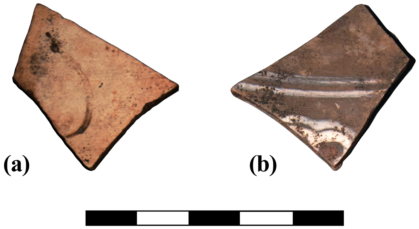
Ionic polychrome sherd (scale in cm) (Irene Liesk).
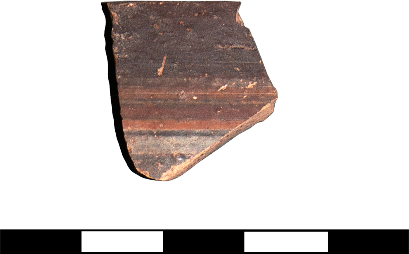
The great majority of the recorded pottery dates to the Classical period. Red-figured pottery is not common. There is a sherd of a local squat lekythos with a palmette, and a sherd of a local skyphos. Black-slipped pottery with a buff fabric containing sparse mica is attributed to local workshops. As with the material of this period from the North Hill, only a small quantity can be considered to be Attic. The commonest shape is the bowl, either without handles and with incurving rim, or with one handle and an out-turned rim. These are mainly local products. There are also various types of kantharos, an askos and a stemmed cup (probably Attic). Wares of orange micaceous clay with many white inclusions were also locally produced. Jugs of many types predominate among the finds. Several transport amphora fragments belong to the well-known Mendean type. There are also black-slipped Attic and local lamps.
There is no Hellenistic or Roman pottery. From the Byzantine period there are some fragments of yellowish glazed vessels that are attributable to the last occupation of the site and the Byzantine structure that Robinson excavated here.
The faunal material from the North and South Hill excavations (SMS)
The faunal material provides an additional form of evidence which links some of the Project's different analytical scales: although unburnt bone has very rarely survived in the deposits investigated at Olynthos so far, small amounts of material have been recovered from both the North and South Hills, facilitating comparison between the two areas. The faunal remains provide an independent line of evidence regarding food ways and the domestic economy in each. The data are summarised in Table 1. (A full catalogue and discussion of the individual contexts will appear in a future publication.) The table counts identifiable bones and fragments of bones that include at least 50% of a unique anatomical zone, or at least 50% of the whole element. Identifiable but non-unique shaft fragments, and tooth fragments that are less than 50% complete, have not been included. Sheep and goat bones have been combined in the sheep/goat category, since most of them cannot be identified confidently to species level. Three of the sheep/goat fragments were identified as being from goats (two fragments of skulls with their horn cores and one metapodial fragment). No items were confidently identified as sheep. All of the identified items are unburnt.
Identified animal bones recovered from 2015 and 2016 excavation seasons.

Most of the other bones come from C9013 and C10021. As noted above, TT09 C9013 produced several unburnt animal bones: these came from room (cc) (the ‘flue’ of B ix 5, the house to the north of B ix 6). Its ashy matrix could explain the preservation of the unburnt bones, since ash and charcoal introduce alkaline materials into the sediment so that it has a more neutral pH than most of the deposits on the North Hill. In addition, the presence of several unburnt animal bones could itself have affected the ambient conditions of a sediment, producing a ‘micro-habitat’. Even so, the bones were not perfectly preserved and some were impossible to lift and transport intact (such as a cattle tibia with a proximal epiphysis).
These bones resemble primary butchery waste (the articulating ankle and toe bones) plus some food preparation waste (the butchered lower limb bones). The radius has definitely been butchered with a heavy blade at the elbow joint, and the longitudinal splitting of the tibia fragments is almost certainly a further indication that the bones have been used for food, since their breaks follow spiral fractures which occur in fresh bone that still retains its collagen. In contrast, the split metacarpal shaft follows straight-line fractures, which tend to occur after the organic component has decayed, and can happen naturally due to expansion and contraction.
None of the burnt bones could be identified to species or skeletal element, but it may be significant that only sheep-sized burnt bones were recovered. None of the cattle bones were burnt, nor was either of the two pig items (one bone, one tooth). This may suggest different disposal practices for remains from different species. The sheep-sized bones could have been used as fuel, or thrown onto fires as a form of waste disposal. It is also possible that the burnt bones (unidentified to element) were table waste rather than butchery or kitchen waste.
All items from C10021 could belong to one element, an almost complete unburnt pig mandible (lower jaw). Despite the context containing some ash and charcoal in the sediment matrix, the bone is in very poor condition. The front part of the jaw is missing, and it is not possible (anywhere on the remaining bone) to see whether or not there were any butchery or skinning marks on it, due to the eroded surface. Pig skulls contain and are covered by substantial portions of meat (tongue, cheek etc.). The cheek teeth are informative about the age at death. All of the adult dentition is fully erupted, but the third molar is unworn, indicating that it had only just completed its eruption (which happens at about 17–22 months). Whatever ageing method is used (which might affect exactly the number of months at which teeth are assumed to erupt), there is a consensus that this is the prime meat-slaughter age for a pig: it has just reached its full adult size, but is still young and tender. Wright et al. (Reference Wright, Viner-Daniels, Parker Pearson and Umberto Albarella2014) conclude that until recently pigs probably only farrowed once a year, in the spring. Under intensive rearing methods, however, pigs can have more than one litter per year, and urban settlements may have provided these conditions.
Discussion
Although the bones represent a very small collection (about 60 fragments), at least three species have been identified. All of the identified species are domestic livestock, commonly raised to provide a range of commodities and resources including food, wool, milk, dung and traction. The identified species are cattle, goat (possibly plus sheep) and pig. There is no indication of any wild animals (mammals, birds or fish), and no bones from working or companion animals such as donkeys, dogs and cats, nor domestic birds such as ducks, geese or chickens. The numbers of fragments suggests that goats (and possibly also sheep) were the most numerous in terms of identified specimens, followed by cattle, and with only a few items from pigs. The estimated minimum numbers of individuals suggest that cattle may have been as common as goats and sheep, but the sample size is extremely small and easily affected by isolated occurrences. Given the sample size, the identification of three species is remarkable, and the absence of others cannot be interpreted as evidence of absence from the site.
The presence of elements from skeletal extremities (heads and feet) suggests that whole animals were kept in or brought to the houses and slaughtered there (possibly in a courtyard, pastas or stenopos): this may indicate the ownership and husbandry of animals by people living in the city. Pigs could have been kept on site all year round and fed on waste (and taken out for pannage in the autumn to fatten up). Goats, sheep and cattle are more likely to have been out in the landscape during the day, although they may well have been brought into a secure location such as a courtyard or pastas at night, for protection against wild animals and thieves.
The field survey beyond the fenced archaeological site (DLS)
In addition to investigating the two best-known districts of Olynthos, the North and South Hills, the Olynthos Project has sought to create a holistic picture of the Classical city by locating and defining the boundaries of additional residential areas lying outside the fenced archaeological site. Evaluation of the date, range and proportions of the ceramics and other finds from different areas will contribute to our overall understanding of the development of the city, as well as the character and role of its different neighbourhoods.
The initial stages of fieldwalking in the immediate hinterland of Olynthos concentrated on the land surrounding the fence of the archaeological site. In 2014 the Project worked to the east and south-east of the site, in 2015 to the east and north-east, and in 2016 to the north and west.Footnote 13 A brief summary of the results from 2014–16 is presented here.
Fieldwalkers collected many types of artefacts. The most common were pottery and tile, followed by millstones, loomweights, chipped stone, slag, plaster, mortar, brick, metal, and small quantities of other artefacts, including terracotta and pebbles (from mosaics). The majority of the ceramic material that could be dated belonged to the Classical period. Late Roman and Byzantine ceramic evidence was also present, but formed a much smaller proportion of the assemblage. Only a very small percentage of the material could be dated to the Neolithic, Bronze Age, Archaic, or Hellenistic periods.
Fig. 31, a density map of all pottery (excluding tile) by weight, indicates extra-urban concentrations. These are not only in areas previously known to have occupation, such as the Lower City (Robinson's ‘Villa Section’), but also on the east side of the site, to both the north and south of the Lower City; on the east side of the North Hill, along the ridge on which the East Cemetery excavated by Robinson lies; and about 600 m to the West of the North Hill in the vicinity of the twelfth-century Church of Aghios Nikolaos that was also excavated by Robinson. With the exception of the material near Aghios Nikolaos, where both amphorae with combed decoration and fine ware with green, white and brown glazes were discovered, all of the concentrations contained material dating predominantly to the Classical period. Some of the concentrations are notable for the number of non-ceramic finds collected. The distribution of wall plaster in the 2014–16 data (Fig. 32) suggests that ancient occupation may have extended beyond the boundary of the modern archaeological site on both its eastern and western sides, in addition to the Lower City. This distribution offers a preliminary indication of where the Olynthos Project field survey thinks these boundaries of the city – never defined by Robinson – might lie, although further testing of this issue through geophysical survey and artefact study is planned.
Density of pottery from fieldwalking, 2014–16 (DLS, HP).

Distribution of plaster from fieldwalking, 2014–16 (DLS, HP).

Concentrations of other artefacts in the fieldwalking data will also be analysed in order to model the distribution of settlement or alternative land-use in the immediate hinterland. The survey has discovered a human tooth in proximity to in situ tiles exposed by erosion on the slope of the North Hill; since the cemeteries excavated by Robinson contained many tile graves, this is a very good indication of a new cemetery location. A concentration of pithoi and tiles may indicate an ancient farmhouse. A very localised distribution of brick and building stone of recent date may indicate the location of a modern rural structure.
One of the notable results of the field survey so far has been the lack of artefacts in the lower elevations (Fig. 31). Near the borders of the Olynthios river very little ancient material was located. Additionally, in proximity to dry river beds running through the Study Area there were few finds. Whether this is due to alluvial or colluvial activity, to modern agriculture, to cultural factors in antiquity or to a combination of these requires further study.
CONCLUSIONS (LCN, ZHA, EBT, DLS)
The Olynthos Project is still in the process of analysing the data already collected, and further field work is anticipated in order to address fully the goals laid out in the Introduction. Nevertheless, a significant amount of new information has already been learned about the city, demonstrating the potential of the Project's multi-scalar, interdisciplinary research design to reveal both the organisation of urban and domestic space, and the dynamics of the community once inhabiting it.
On the North Hill, the layout of the city has been clarified through geophysical survey, showing that Robinson's plan needs modification: Block B xii, the final block of houses, represents a single row of structures, rather than the double one he visualised (Robinson Reference Robinson1946, Sketch Plan). The space beyond now starts to emerge as a less regularly organised group of buildings with a history of significant modification and perhaps non-domestic use (as suggested by TT03), raising questions about the nature and timing of the city's expansion onto the North Hill. Excavation also shows that the fortification wall along the north-east edge of the hill was built largely of mud brick on a gravel footing, with a rubble exterior facing (TT04). The geophysical survey further suggests that there may also have been a second fortification wall behind this one. At the same time, the excavation of TT02 also sheds light on Robinson's excavation strategy, revealing that his aim in opening up long narrow trenches is likely to have been to detect the presence of buildings and approximate the locations of walls, but that he did not excavate fully or try to interpret the individual deposits he encountered.
Investigation in house B ix 6 has revealed that the resistance results provide a reliable guide to the architectural layout. So far, evidence has been gathered mainly of activities taking place in the northern range of rooms and courtyard, and possibly also the upper storey. Statistical analysis of the distribution of artefacts must wait until excavation is complete, but preliminary indications suggest that fine pottery is concentrated in the northern part of the house, while the southern areas excavated so far have yielded more medium wares. The application of scientific techniques is starting to contribute additional information. Micro-debris study suggests that the pastas and flue were important areas for food preparation. Faunal analysis shows that a range of meat was processed and consumed within the house, and work is under way to explore other aspects of subsistence practice through analysis of macro botanical remains, phytoliths and starches. At the same time, micromorphology is starting to identify and reveal the use of a range of different floor surfaces, while geochemistry is characterising some of the activities carried out on those surfaces. Together these data promise a new approach to understanding in detail the organisation of domestic activity based on multiple, independent lines of evidence.
The combined application of the three different investigation methods (geophysical survey, intensive surface survey and excavation) on the South Hill has also yielded fulfilling results. It has revealed that the entire hill was inhabited. There was a city plan consisting of north–south streets meeting parallel sets of curved east–west streets with irregularly organised building blocks. Further evidence on the dating of the plan and the history of the settlement can be obtained only through further (deeper) excavation, and this will be a very important part of future seasons, revealing the character of the early settlement and showing how it grew and changed over time. This will shed important new light on this city, which survived for almost four centuries, developed trade relations with cities of southern Greece and Ionia and played an important role in the history of the whole region. Ultimately, this work will not only increase our knowledge of the history and development of Olynthos itself, but will also contribute to a broader understanding of urbanisation and the formation of complex society in the northern Aegean.
Through our field survey data, the boundaries of the ancient city are also becoming better understood. The dense distribution of surface artefacts suggests that occupation extended further north and south along the east side of the North Hill than was detected by Robinson's excavations. Occupation may also have existed to the west of the North Hill, where there are dense surface scatters with household artefacts. A broad cemetery district can also be postulated on the slope of this hill. In the immediate hinterland of the ancient city, ploughing of tree crops regularly brings ancient materials to the surface. Along the ridge where Robinson discovered the East Cemetery, the Project's field survey has discovered a high density of surface material, and it is possible that a suburban settlement contemporary with the Classical city of Olynthos may have been located here. Late Roman and Byzantine materials were identified in the vicinity of the twelfth-century Church of Aghios Nikolaos that was also excavated by Robinson. The existence of a village in this location is likely.
The evidence of artefacts has also begun to shed light on aspects of the city's economy, showing how both the household occupying B ix 6, and the city as a whole, were integrated into local, regional and supraregional trading networks. Although only preliminary comments can be made at this stage, it seems that rather than being closely tied to Athens, as Robinson's analysis of his fine-ware ceramic assemblage might suggest, Olynthos is most strongly connected with more local trading centres. Much of the ceramic assemblage in use seems to have been of local or regional, rather than Attic, production. A similar pattern is starting to emerge from preliminary study of the transport amphorae, the majority of which seem to be from local Chalkidiki workshops, with only occasional examples from further afield. Additional study of the ceramics, together with analysis of other artefact classes (including tile and iron objects), promises to extend this picture.
ACKNOWLEDGEMENTS
The Olynthos Project is a synergasia between the British School at Athens and the Greek Archaeological Service (Ephorate of Chalkidiki), with permission from the Hellenic Ministry of Culture and Sports. We are very grateful to these organisations for their support. We would also like to thank the following for their sponsorship: the University of Michigan, Ann Arbor (Department of Classical Studies, Kelsey Museum of Archaeology and Office of the Vice-President for Research); the University of Liverpool (Department of Archaeology, Classics, and Egyptology, in the School of Histories, Languages, and Cultures); the Ephorates of Chalkidiki, Pella, Thessaloniki region and Kilkis; the National Geographic Society (grant number 9759-15); the Loeb Classical Library Foundation (awarded 2016); the British Academy Small Grants Scheme (awarded 2016).
The Olynthos Project is directed by Bettina Tsigarida (Greek Archaeological Service, Ephorate of Pella), Lisa Nevett (University of Michigan) and Zosia Archibald (University of Liverpool). Specialists and advisers who took part in the 2014–16 seasons were: Dr Evi Margaritis, Cyprus Institute (archaeobotany); Professor Bradley Ault, SUNY Buffalo, Dr Anna Panti, Greek Archaeological Service and Professor Kathleen Lynch, University of Cincinnati (ceramics); Dr Sue Stallibrass, University of Liverpool (faunal analysis); Dr David Stone, University of Michigan (field survey and digital data); Mr G. Tsolakis, Ephorate of Chalkidiki (foreman); Dr Sean Taylor, University of Cambridge (geoarchaeology); Dr Carla Lancelotti, Universitat Pompeu Fabra (geochemistry, phytolith and starch analysis); Dr Hannah Pethen, University of Liverpool (GIS); Mr Filippos Stefanou, Thessaloniki, Mr John Manousakis, Elxis Group, Athens and Professor Dimitrios Zekkos, University of Michigan (photogrammetry and drone photography); Mr Nikos Alexakis, Mr Michaelis Tsioumas and Mr Vassilis Andreou, Greek Archaeological Service (topography). Ms Lorene Sterner of the Kelsey Museum of Archaeology, University of Michigan, prepared the trench drawings from the 2014 season for publication. Our heartfelt thanks go to the many volunteer supervisors and team members without whom this work would not have been possible.