INTRODUCTION
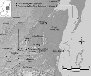
In 1857, over 1,000 Maya left the village of Chichanha in present-day Campeche, fleeing a decade of violence from the ongoing Caste War, and settled in the lightly populated forests of what are today northern Guatemala and northwestern Belize (Dumond Reference Dumond and Jones1977; Jones Reference Jones and Jones1977). The new inhabitants unwittingly left one geopolitical conflict for another one, inhabiting land contested by British Honduras, which is today Belize but was then an ambiguously defined settlement of Great Britain, and the fledgling nations of Mexico and Guatemala, which the dissolution of the Spanish Empire had spawned. Jones (Reference Jones and Jones1977) bestowed the name “San Pedro Maya” on this group of migrants who settled in three “minor clusters” of villages: two in British Honduras and one in northeastern Peten, Guatemala (Figure 1). The name derives from their principal village of San Pedro Siris in the Yalbac Hills of western British Honduras (Kray et al. Reference Kray, Church, Yaeger, Armstrong-Fumero and Gutierrez2017:56).
Map of San Pedro Maya sites in and near northern British Honduras. The Holmul (HMC), San José (SJMC), and San Pedro (SPMC) minor clusters are shown, modified from Jones (Reference Jones and Jones1977:Map 5-1). Site locations after Church et al. (Reference Church, Yaeger, Dornan, Liebmann and Murphy2011:Figure 9.1) and Jones (Reference Jones and Jones1977:Map 5-1). Base map courtesy NASA/JPL-Caltech, SRTM Mission.

Although historians and ethnographers have studied the San Pedro Maya for some time (Bolland Reference Bolland2003; Cal Reference Cal1991; Dumond Reference Dumond and Jones1977; Jones Reference Jones and Jones1977; Reed Reference Reed1964), archaeologists did not begin investigating them until the early 2000s (Leventhal et al. Reference Leventhal, Yaeger and Church2001; Yaeger et al. Reference Yaeger, Church, Leventhal and Dornan2004). To date, the only three excavated San Pedro Maya settlements are San Pedro Siris (Church et al. Reference Church, Yaeger, Dornan, Liebmann and Murphy2011, Reference Church, Yaeger, Kray and Orser2019; Dornan Reference Dornan2004; Kray et al. Reference Kray, Church, Yaeger, Armstrong-Fumero and Gutierrez2017; Leventhal et al. Reference Leventhal, Yaeger and Church2001; Yaeger et al. Reference Yaeger, Church, Leventhal and Dornan2004), Holotunich (Ng Reference Ng2007, Reference Ng2010; Thornton and Cackler Reference Thornton, Cackler, Götz and Emery2013), and Kaxil Uinic (Bonorden Reference Bonorden2016; Bonorden and Houk Reference Bonorden, Houk and Orser2019; Bonorden and Kilgore Reference Bonorden, Kilgore and Houk2015, Reference Bonorden, Kilgore and Houk2016). We refer the reader to those other sources for more in-depth discussions of the material culture recovered from each site and primary excavation data.
While the other papers in this Special Section have focused on primarily on shifting frontiers between polities, ethnopolities, and cultural or interaction spheres during the pre-Columbian periods, this article examines primarily the western border of British Honduras itself, both as a political concept and a physical manifestation of that concept, specifically as it relates to the San Pedro Maya living at Kaxil Uinic village. We have put “borders” in quotation marks in the title of this article to stress the permeability and shifting nature of the colony's boundaries. In many ways, the western British Honduras and northeastern Peten region, where the San Pedro Maya lived, was also a cultural frontier, an interstitial zone where multiple cultural and political groups interacted, as described by Halperin and colleagues (Reference Halperin, Freiwald and Iannone2020). Our research and this article are not immune to the effects of the border: because we conducted our fieldwork in Belize, our investigations at all phases aimed to explore the relationship between the San Pedro Maya at Kaxil Uinic and the political and economic forces of British Honduras. The end product is a focus on the San Pedro Maya of British Honduras at the expense of those living in Guatemala in what Jones (Reference Jones and Jones1977:193) dubbed the Holmul minor cluster (Figure 1). Indeed, Jones (Reference Jones and Jones1977:162, 164) proposes that San Pedro Maya from Holhuitz in northeastern Peten may have settled Kaxil Uinic after abandoning their village sometime after 1868.
Our study is based on archival research in Chicago (Houk Reference Houk and Houk2012), Belize, Jamaica, and England (Bonorden et al. Reference Bonorden, Lee, Houk, Houk and Novotny2017) and two seasons of archaeological investigations at Kaxil Uinic (Bonorden Reference Bonorden2016; Bonorden and Houk Reference Bonorden, Houk and Orser2019; Bonorden and Kilgore Reference Bonorden, Kilgore and Houk2015, Reference Bonorden, Kilgore and Houk2016). The complex political and historical situation surrounding Great Britain's claim to what was then British Honduras (and is now Belize), the colonists’ fear of connections between Kaxil Uinic and Icaiche (a Maya village in Mexico and a Maya group named after that village), and the choking grip the Belize Estate and Produce Company (BEC) had on private land in the colony conspired against the San Pedro Maya's desire for autonomy. Ultimately, the Maya's ambivalence toward the border provided BEC with an excuse to move the residents from Kaxil Uinic village, one of the first steps in the final eviction of the San Pedro Maya from the forests of northwestern British Honduras.
A BRIEF HISTORY OF THE BORDERS OF BRITISH HONDURAS
Before discussing the San Pedro Maya, we are compelled to address the complicated history of the borders of British Honduras. In fact, there have been problems with the western border of British Honduras, in particular, for longer than there has actually been a colony of British Honduras. The complexities of the situation are beyond the scope of this paper and have been the subject of entire books (Bianchi Reference Bianchi1959; Bloomfield Reference Boomfield1953; Humphreys Reference Humphreys1961; Mendoza Reference Mendoza1959), but the failure of Great Britain and the colonial government to negotiate clearly defined borders with their neighbors when the colony was officially established in the 1860s led to numerous conflicts in the mid- to late-nineteenth century. The controversy surrounding the western border remains a significant issue today, one that now rests with the International Court of Justice (2019).
Borders as Political Constructs
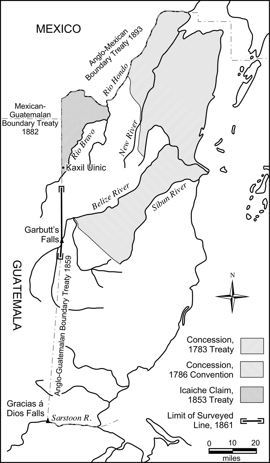
The Treaty of Paris in 1763 formally granted Britain permission to cut logwood on the Bay of Honduras for use in making dye (Humphreys Reference Humphreys1961:3). The subsequent Treaty of Versailles in 1783 and the Convention of London in 1786 defined and then expanded, respectively, the limits of the wood cutting concession (Figure 2) and added mahogany to the list of trees that could be harvested (Humphreys Reference Humphreys1961:5–6). The logging concession occupied a portion of what is today the northern part of Belize (Figure 2). The treaty largely responsible for expanding the boundaries to their current limits is the Wyke-Aycinena Treaty of 1859, also referred to as the Anglo-Guatemalan Boundary Treaty of 1859. That treaty described the borders between Guatemala and the settlement of British Honduras as following the middle of the Sarstoon River's channel to Gracias á Dios Falls, turning north from there to Garbutt's Falls, and then continuing due north from Garbutt's Falls to the Mexican frontier (Bianchi Reference Bianchi1959:60). Article 7 of that agreement is the major point of contention, which continues to present-day. In it, Britain and Guatemala agreed to construct, jointly, a cart road from the Atlantic coast to Guatemala City, but they never constructed the road. Without wading into the complexities of international treaty law, “the Guatemalans have long claimed that they ceded certain territory…to Britain in the treaty of 1859. Article 7 was put in the treaty, they say, to compensate them for that cessation” (Clegern Reference Clegern1967:100). Thus, Guatemala maintains that, since the road was never built, the treaty is void.
Map of the borders of British Honduras as defined by various treaties after Waddell (Reference Waddell1981:Figure 3) with Icaiche claim. After Cal (Reference Cal1991:Figure 6.1).

While the failed implementation of Article 7 has led to over a century and half of conflict between the involved governments, in 1859 the western border of the settlement was not the only boundary in question. The Caste War, political upheaval across Mexico, including the French intervention from 1862 to 1867, and a complete lack of diplomatic relations between Mexico and Great Britain from 1867 to 1884 also prevented efforts to formalize the northern border of British Honduras for decades (Clegern Reference Clegern1967:135). Clegern (Reference Clegern1967:135) notes the “northern periphery of British Honduras suffered disorder in the late nineteenth century because southern Yucatan was a counter-claimed and uncontrolled area which lay between two different [colonial] cultures and harbored militant remnants of a third.” This decidedly colonial point of view ascribes primacy to the first two cultures in Clegern's assessment, the colonial entities of Mexico and British Honduras. The third culture mentioned by Clegern is the Maya, the traditional occupants of the area, who included the Santa Cruz Maya (in open rebellion against the government in Yucatan) and the Pacificos del Sur/Icaiche (the group from which the San Pedro Maya split).
From the British perspective, the Pacificos, so called because of their pacifist views toward the conflict with Mexico, somewhat ironically posed the greatest threat to the colony's security. Following their move farther to the south from Chichanha in early 1863 (Jones Reference Jones and Jones1977:145), the Pacificos became known as the Icaiche, after the name of their new head town. The Icaiche frequently demanded rent from logging operations, which they contended were cutting logs on the “Mexican side” of the border, and sometimes raided those logging works that did not pay (Dumond Reference Dumond and Jones1977).
It is likely that the Icaiche justification for these demands came from the 1853 Treaty of Belize between the Pacificos and the government of Yucatan. The treaty granted the Maya the lands that they already effectively controlled, which encompassed what would eventually become northwestern British Honduras (Figure 2). Although the British were not a party of the treaty, Superintendent Wodehouse from British Honduras signed it as a third-party witness. By “co-signing the document, the Icaiche reasoned, the British recognized Icaiche control over part of the lands that eventually became the Belizean northwest” (Cal Reference Cal1991:336). Cal's (Reference Cal1991:Figure 6.1) interpretation of the archival sources suggests the Icaiche perceived their territory to include the land south of the Rio Hondo and west of the Rio Bravo.
One of the most significant events in the complicated history of British-Maya relations was the 1866 raid on Qualm Hill, a British Honduras Company (BHC)—the predecessor to BEC—mahogany bank on the Rio Bravo in northwestern British Honduras. Led by Marcus Canul, the comandante general of the Icaiche, this event resulted in the death of two men and the capture and subsequent ransom of an English foreman, a Canadian, and dozens of Creole men, women, and children inhabiting the logging camp (Bolland Reference Bolland2003:78; Burdon Reference Burdon1935:269; Jones Reference Jones and Jones1977:150).
Fearing that the San Pedro Maya had allied with the Icaiche, the British responded by marching on San Pedro Siris, the principal settlement of the group, in December of 1866, but the San Pedro Maya defeated the British and routed their forces. The British eventually retaliated and burned San Pedro Siris in 1867 (Jones Reference Jones and Jones1977:150–151). The British later repelled another Icaiche raid in 1872 during the Battle of Orange Walk in northern British Honduras, and Canul subsequently died from injuries sustained during the battle (Eltringham Reference Eltringham2010:79).
The British generally enjoyed friendlier relations with the Santa Cruz Maya (Reed Reference Reed1964:205) and turned a blind eye to merchants in the colony who traded weapons and ammunition to them, which the Santa Cruz Maya used against the Mexican forces (Bolland Reference Bolland2003:75). It is not a stretch to say that the British used the Santa Cruz Maya as a surrogate to weaken Mexico's power in the area. The Santa Cruz Maya moved freely across the de facto northern border of the colony, the Rio Hondo, and perhaps as many as 10,000 Maya lived around the town of Corozal in the 1860s (Reed Reference Reed1964:205).
After decades of political maneuverings beyond the scope of this paper, the governments of Britain and Mexico ultimately signed a treaty in 1893, establishing the border along the Rio Hondo and up Blue Creek to a point due north of the boundary between Mexico, British Honduras, and Guatemala. Additionally, the two parties agreed to prohibit supplying weapons and ammunition to the Maya groups along the border, and to endeavor to prevent Maya incursions across the border (Humphreys Reference Humphreys1961:148–149). Nevertheless, positive memories of British support persisted for decades among the Santa Cruz Maya, and Sullivan (Reference Sullivan1989) recounts multiple historical and archival sources attesting to a desire by Santa Cruz representatives to join the British as late as the 1930s.
Borders as Political Aspirations
Besides complicated legal and political histories, the northern and western borders of British Honduras share another thing in common: they are both artificial borders grounded not in cultural or historical validity, but rather in the politics of empire building and colonial appropriation. Clegern (Reference Clegern1967:148–149) notes that, in the case of British Honduras’ northern border, “the Hondo was the center rather an edge of a geographical region, and most of the complications of settlement related to this fact.” Indeed, Walker's (Reference Walker2016) recent book, Perspectives on the Ancient Maya of Chetumal Bay, demonstrates the predominance of the region throughout Maya prehistory as a vibrant area of commerce and long-distance exchange. Of the western border, Clegern (Reference Clegern1967:97) observes, “the boundary of Petén with the colony is entirely artificial—a surveyor's line through the wilderness tied to only two previously discernible landmarks.”
Church and colleagues (Reference Church, Yaeger, Kray and Orser2019:78) refer to these borders as aspirational, noting that following the breakup of the Spanish Empire, “postcolonial boundaries were shifting and contested over the course of decades; state boundaries were more statements of ideal and ambition than they were real.” Wedged in among the administrative remnants of the Spanish Empire sat the settlement of British Honduras, which did not become a colony until 1862, was governed from Jamaica, and did not become a Crown colony with its own governor until 1871 (Setzekorn Reference Setzekorn1981:181, 189). Its two centuries “of ill-defined status with questionable boundaries and confusing government structures” (Setzekorn Reference Setzekorn1981:181) made the settlement's boundaries as “fluid” and “confounding” as those of its Spanish-speaking neighbors (Church et al. Reference Church, Yaeger, Kray and Orser2019:77). In the case of the settlement's western border, not only was it aspirational in 1859, its northern limit was unknowable, as the border between Guatemala and Mexico had yet to be established and there was no agreement on the frontier between British Honduras and Mexico. Furthermore, the region was largely unexplored and unknown, so even physical markers, such as Blue Creek, a tributary of the Rio Hondo mentioned as one of the possible northern termini of the western border (Humphreys Reference Humphreys1961:100–101), had not been properly mapped. While Blue Creek could serve as an aspirational boundary, it could not serve as a formal one until its actual course was determined. Perhaps the primary beneficiary of this ambiguity was BHC/BEC, which found itself able to extend its commercial activities into contested zones with little or no interference from the colonial government.
To complicate matters further, in 1864 the short-lived empire headed by Maximilian of Austria aspired to remove the borders entirely and decreed that Yucatan included not only the Peten, but all of British Honduras as well (Humphreys Reference Humphreys1961:133). This bold claim not only caused concern among the colony's administrators but appears to have led the Maya near the northern border to believe the British would abandon the colony (Humphreys Reference Humphreys1961:133).
Borders as Physical Lines
Shortly after the Treaty of 1859 had been signed, Captain Wray of the Royal Engineers initiated the survey of the western border of British Honduras by marking the southwestern corner of the frontier at Gracias á Dios Falls with a stone pyramid on December 8, 1860. He placed a similar monument at Garbutt's Falls a month later and cut a line from that point for approximately 9.7 km (six miles) south, in the direction of the southwestern marker (Humphreys Reference Humphreys1961:98; Setzekorn Reference Setzekorn1981:179). Ironically, by marking the border in such a way—with a constructed feature paired with a natural one, in this case two prominent “falls” on major waterways—Wray mimicked Maya Postclassic methods of marking their borders with shrines (Halperin and Hruby Reference Halperin and Hruby2019). Whether or not this action resonated with the Maya living near the survey markers is unknown. Wray and a Guatemalan commissioner then explored the Rio Hondo to determine which branch of the river was the main stream, ultimately concluding that Blue Creek was the true course of the Hondo. Returning to Garbutt's Falls, Wray cut a line north for approximately 36.2 km (22.5 miles) before stopping in mid-April 1861 due to a lack of available drinking water (Humphreys Reference Humphreys1961:98–99).
At this point in the project, the Foreign Office told him to stop surveying north of Garbutt's Falls until receiving further orders, a delay which resulted in the survey's termination for the remainder of the year due to the impending rainy season. As Humphrey (Reference Humphreys1961:99–100) observes, the reason for suspending the survey included uncertainty about the boundary with Mexico and, perhaps more crucial, complaints from BHC and the logging firm of Young, Toledo, and Company that the proposed route would cede Crown lands where they logged to Mexico or Guatemala. Around this same time, lawyers in London, including one who worked for BHC, drafted the 1861 Honduras Land Titles Act (Kray et al. Reference Kray, Church, Yaeger, Armstrong-Fumero and Gutierrez2017:58), which allowed logging companies to purchase Crown lands in the settlement even if no title existed (Bolland Reference Bolland1977:187). Using this mechanism, BHC purchased one million acres of land, including the Yalbac Hills region, the area occupied by San Pedro Siris and other San Pedro Maya villages (Kray Reference Kray, Church, Yaeger, Armstrong-Fumero and Gutierrez2017:58).
The Icaiche raid on Qualm Hill in 1866 catalyzed the colonial administration to reconsider the borders shortly thereafter. In the months following the raid, officials conceded that “it [was] not quite clear where the Qualm Hill bank [was] situated” (on British or Mexican territory) and “indeed the agents of the company [should have arranged] with the Indians for protection of the labourers” (Minute Paper 1866). Church and colleagues (Reference Church, Yaeger, Kray and Orser2019:92) report that the British Secretary of State sent a dispatch to the Commander of the Admiralty in January 1867, noting that the Qualm Hill raid was caused by the disputed border and the conduct of the loggers operating in Indian territory. About two weeks later, Lieutenant Governor John Gardiner Austin expressed his frustration with “the vacillating policy which had been pursued in not defining the boundary, and the previous payments of ransoms for parties seized on British territory” (Executive Council of the Colony 1867). Of course, the Maya had a very different perspective, believing the border lay farther east as evidenced in Canul's (Reference Canul1865) letter over a year before the raid to Mr. Robateau, the BHC foreman at Qualm Hill, which requested a meeting to discuss the logging of mahogany on Mexican territory. Canul's interpretation, again, may have been based on the Icaiche's participation in the 1853 Treaty of Belize.
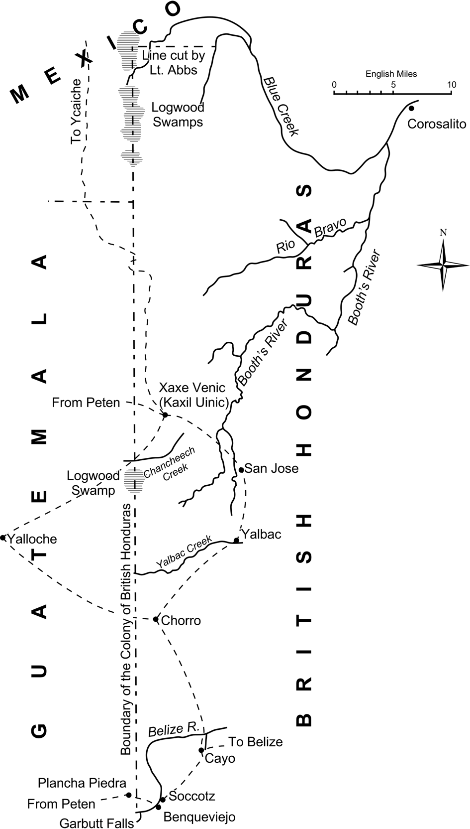
In addition to the punitive military actions taken against the San Pedro Maya in late 1866 and early 1867 in response to the raid on Qualm Hill, Lieutenant Governor Austin decreed that the Maya had to pay rent to the Crown or the land owner for their villages and milpas (Bolland Reference Bolland1977), essentially prohibiting them from owning land, a policy formalized by the Crown Lands Ordinance of 1872 (Bolland Reference Bolland2003:139). The colony's administrators also ordered the work to recommence on cutting the northern and northwestern border in the disputed area of Blue Creek (Figure 3). Lieutenant E.C. Abbs, a naval officer, directed this work and cut a line connecting Blue Creek to the Garbutt's Falls meridian in March and April of 1867. The Governor of Jamaica, Sir J. Grant (who also administered the colony of British Honduras), was reluctant to order the completion of the north-south line which Wray had begun, and the western border remained only a line on paper in the years following Abbs’ survey (Humphreys Reference Humphreys1961:140–141).
Map of the western frontier of British Honduras following the 1884–1887 survey by Miller. Map (after Miller Reference Miller1887) retains the source map's spellings.

The colony again took up the issue of the western border in 1884, two years after Guatemala and Mexico agreed to their shared border between the Peten and Yucatan. Begun in 1884 but not completed until 1887, a new survey extended 104.6 km (65 miles) from Garbutt's Falls to the Abbs’ line at N 17°59′27″ (Humphreys Reference Humphreys1961:144). Miller (Reference Miller1887), the Assistant Surveyor-General of British Honduras, oversaw the completion of the northern 37 km (23 miles) of the survey, and he published a short but colorful account of the work in the Proceedings of the Royal Geographical Society. Miller's (Reference Miller1887:420) description begins by noting the area surveyed was “a part of British Honduras concerning which all existing maps are more or less erroneous.” His crew of 50 men could cut only half a mile per day through logwood swamps near the northern end of his survey, but he reported that the entire border north of Garbutt's Falls had been cut 12 feet wide by the end of the work (Miller Reference Miller1887:420, 422).
Of interest here are Miller's map (Figure 3) and his accounts of the Indian villages near the survey line. He observes, “the Indians of these villages are not savages. They cultivate the soil and grow maize, rice, and beans, and raise pigs and fowls. They are, however, to a certain extent dangerous, as so lately as 1872 they made a successful raid on, and burnt, Orange Walk, one of the chief towns of the colony, where there was a fort and a garrison. They are armed to a considerable extent with old Enfield rifles and the machete, a kind of cutlass, without which travelling is impossible in this country” (Miller Reference Miller1887:422).
His map is informative both for what it shows and what it does not show. For example, Chan Chich Creek, the headwaters of the Rio Bravo, is shown on the map only where it crosses his survey line. Miller (Reference Miller1887:422) notes, “Chan Cheëch creek…no doubt connects with Booth's river or the Rio Bravo, but no person has followed it up to settle this point.” Similarly, he notes of the northern end of the line, “The long narrow lagoon at the northern end of the line marked ‘Ishnoha creek’ joins Blue creek at the point shown. No white man has followed this down, but we have this information from an Indian” (Miller Reference Miller1887:422). Miller's account makes it clear just how arbitrary, alien, and unknown the proposed margins of the colony were to the colonial government.
KAXIL UINIC AND THE WESTERN BORDER OF BRITISH HONDURAS
The following sections present the archival information we have collected that explicitly deals with Kaxil Uinic and the results of our archaeological investigations, specifically as they inform the issue of the “border.” Bonorden (Reference Bonorden2016; Bonorden and Kilgore Reference Bonorden, Kilgore and Houk2016) presents much more detail on the excavations and artifact analysis from the 2015 and 2016 field seasons at Kaxil Uinic.
Archival Information
San Pedro Maya founded Kaxil Uinic sometime prior to 1885, when the village first appears in the archival record. The earliest mention of Kaxil Uinic comes from a statement to the Police Inspector of British Honduras in January 1885 (paraphrased in Jones [Reference Jones and Jones1977:159, 161]), which mentions that several “Mexicans” escaped through the village to Icaiche after committing murders at a mahogany bank near San José Yalbac. The village was located around a small aguada (Houk Reference Houk and Houk2012:36; Thompson Reference Thompson1963:233) and not on the Rio Bravo, as claimed by Jones (Reference Jones and Jones1977:161), approximately two kilometers east of the border with Guatemala (Bonorden Reference Bonorden2016:241).
Although we will likely never know exactly when the San Pedro Maya established the village, it was certainly before a physical line marked the border because the village was already situated around the aguada when Miller's survey team passed by there in 1885. Because no physical line existed, the villagers had perhaps unknowingly moved into territory claimed by British Honduras and onto land owned by BEC. We know from much later correspondence between Thompson and the Conservator of the Forests (1930) that the village sat in the extreme northwestern corner of BEC's Armstrong parcel.
Miller's (Reference Miller1887) map shows the location of Kaxil Uinic, shown as Xaxe Venic, and we believe this is the first map to show the village's location. Of equal note are the trails passing through Kaxil Uinic, which Miller (Reference Miller1887:422–423) describes as “mere paths through the bush.” On Miller's map (Figure 3), trails connect Kaxil Uinic to the Peten and Yaloch (labeled Yalloche by Miller) in Guatemala, San José in British Honduras, and Icaiche in Mexico. Reed's (Reference Reed1964:205) description of “the one trail to Belize” from Icaiche as a “tunnel in certain parts” likely refers to the route's passing through dense brush. Thus the map and other accounts suggest Kaxil Uinic occupied a crossroads of sorts connecting San Pedro Maya villages in the Peten and British Honduras with other Maya in Mexico.
Although Miller (Reference Miller1887) makes no mention of difficulties with the Maya in his report in the Proceedings of the Royal Geographical Society, other archival sources suggest the villagers at Kaxil Uinic reacted with hostility toward the survey party and perhaps had closer ties to Icaiche than other San Pedro Maya did. Cal (Reference Cal1991:365) goes as far as to say that Kaxil Uinic was “a village the Icaiche had always regarded as their own.” In January of 1886, Governor Goldsworthy wrote to General Tamay, the leader of the Icaiche, asking him to order the alcalde of Kaxil Uinic to stop interfering with Miller's survey party (Bolland Reference Bolland2003:149). The alcalde considered his village to be in Mexican territory (Bolland Reference Bolland2003:149), and the village falls within Cal's (Reference Cal1991:Figure 6.1) map of the area covered by the 1853 treaty. Later that same year, on August 18, 1886, Gastrell (Reference Gastrell1886) sent the Earl of Rosebery a letter and map, which showed the perceived northern boundary line and was annotated with the locations of “Ycaiché” Indians, who “[kept] their power or jurisdiction to nearly as far south as Garbutt's Falls and control…Xaxa Venic [Kaxil Uinic] which [was then] supposed to be within [the] Belize frontier.” In response to the survey party, the Icaiche marked the contentious boundary between British Honduras and Mexico with Mexican flags against the wishes of the government in British Honduras (Currie Reference Currie1887). In sum, the Maya, who were not party to the formal treaty negotiations between the colonial powers—other than the 1853 treaty which Mexico and Britain failed to ratify—continued to contest the boundaries even as Guatemala, British Honduras, and Mexico moved to formalize them.
The archival record suggests a lingering concern on the part of the British and the colonists over the perceived relationship between the villagers at Kaxil Uinic and the Icaiche Maya, a persistent thread of the British-San Pedro Maya narrative stretching back to the Qualm Hill raid and the Battle of San Pedro, almost two decades before Kaxil Uinic first appears in official documents. St. John (Reference Zuc1888) wrote that “the Indians who threatened to interfere with the survey of [the British frontier] were those living south of the boundary line between Mexico and Guatemala….as part of the Ycaiché tribe, they considered themselves as under the government of the State of Campeche.” Miller (Reference Miller1887:422), without naming a particular group in his report, also associates the residents of the villages he passed on his survey, such as Kaxil Uinic, with the Icaiche who attacked Orange Walk in 1872.
The language used by even the most adventurous writers of the time appears to reflect a genuine fear of the Icaiche. Miller (Reference Miller1887:423), in his survey report, wrote, “The position of Ycaiche has always been doubtful… The doubt concerning this town is to be accounted for by the terror which the Ycaiche Indians inspire.” Eight years later, the intrepid explorer of Maya ruins Maler passed through the abandoned village of Santa Rita on his way from Merida to Lake Peten-Itza. Describing Santa Rita, Maler (Reference Maler1910:151) noted “a path branches to the left, to the east, toward Kaxilvinic [Kaxil Uinic], three day's journey distant, and Icaiché, the dread retreat of the free Mayas, is two days distant from Kaxilvinic.” It is unclear from the archival record how much of this fear is legitimate and how much is the result of colonial propaganda. As modern politics show, demonizing the “other” is an effective means to spark fear among the populace, making it easier to justify otherwise morally questionable policies.
As for the Maya and their perception of the border, Church and colleagues (Reference Church, Yaeger, Kray and Orser2019:77) contend that “various configurations of Maya polities in this region, from the late eighteenth through the late nineteenth centuries, consistently understood Black Creek and the New River lagoons to be their border with the British loggers and settlers, and later the colony of British Honduras.” While certainly plausible, it is also likely that the 1863 treaty and the 1864 decree by the short-lived Maximilian empire claiming all of British Honduras and the Peten as part of Mexico influenced the San Pedro Maya's thinking (Humphreys Reference Humphreys1961:133). In any case, the archival record reflects persistent disagreements about the border's location by both San Pedro Maya and the Icaiche Maya even after the British cut a physical line through the forest.
It seems that from a practical standpoint, the Maya largely ignored the border both before and after it was cut. For example, Jones’ (Reference Jones and Jones1977:146–148) extensive archival work in Belize shows that the Maya in the Holmul minor cluster, despite their having political connections to Flores, the center of Guatemala's government in Peten, recognized San Pedro Siris as their own capital in the 1860s. Jones (Reference Jones and Jones1977:146–148) pieced together the events surrounding a failed attempt by several Holmul cluster villages to split from the San Pedro Maya and join with the Guatemalan government; while the story itself is fascinating, from our perspective the internal political processes and the free movement of San Pedro Maya between Holmul and San Pedro Siris speak to the Maya's disregard for the border. One outcome of the so called “Lino Lara affair” described by Jones (Reference Jones and Jones1977:146) was that the colonial superintendent, Frederick Seymour, dispatched Edward L. Rhys to appoint alcaldes in the San Pedro Maya villages. Jones (Reference Jones and Jones1977:146) notes, “Rhys did appoint officials at the principal villages on the British side but did not visit the villages of Tubleche, Holmul, Holuitz, Chunbalche, and Naclicah, as they were said to be on the Guatemalan side of the frontier.” Twenty-five years later, the trails reported by Miller and by future travelers show that the line cut through the jungle did not prevent villagers or others from crossing freely between Guatemala and British Honduras.
The San Pedro Maya, however, could not avoid another colonial imposition: paying rent to BEC. Although it is not clear when the villagers at Kaxil Uinic first began paying rent, a telegram from the Conservator of Forests (1930) to Thompson noted that BEC was collecting rent in 1930. As noted above, legislation passed following the Battle of San Pedro that prohibited the Maya from owning land and required them to pay rent to the registered owner. As Kray and colleagues (Reference Kray, Church, Yaeger, Armstrong-Fumero and Gutierrez2017:65) observe:
People who were children in San José [another San Pedro Maya village in British Honduras] in the 1930s told us that to pay their rents, their fathers worked on support crews for the mahogany companies or in chicle (natural gum) bleeding. The chicleros often set out for months at a time, sometimes deep into the Petén forest to the west in Guatemala, harvesting the chicle tree's sap to satisfy the growing taste for chewing gum in the United States.
The San Pedro Maya and BHC/BEC frequently found themselves at odds over their contrasting land use patterns. BHC/BEC viewed Maya traditional milpa farming as destructive to timber resources (Ng Reference Ng2007:68; Thompson Reference Thompson1939:4). Conversely, the Maya complained that the cattle used by loggers to haul felled timber to nearby rivers for transport wreaked havoc on their milpas (Cal Reference Cal1991:249–250; Zuc Reference Zuc1856). Thus, one might suppose that BEC would have welcomed chiclero work by the Maya as a preferable alternative to milpa farming, but the archival record indicates friction over this pursuit as well. A report published in 1908 conveyed that the colonial government considered the chicle industry to be profitable yet destructive, “carried on with a total disregard for the life of the tree [and lacking] proper regulation and supervision of the Chicle collection” (Starkey Reference Starkey1908). A year later, the manager of BEC wrote to colonial secretary C. Rees Davies that chicle bleeders were illegally working along the British Honduras-Guatemala border, and that the company would be willing to fund the clearing of this boundary line to prevent such illicit activities (Usher Reference Usher1909)—this document suggests that the forest had reclaimed the border in the 20 years since Miller's survey.
Indeed, once established, the border served as a firm limit for BEC's timber operations but posed no constraints on the Maya and their chicle harvesting. Chicleros from the British Honduras side of the border worked in the Peten legally, buying a permit to work (boleto) and paying excise tax to export chicle into British Honduras, and also illegally. In his 1931 field notes, Thompson (Reference Thompson1931) records that chicleros were paid $15 for 100 pounds of chicle, but had made as much as $80 during World War I, and that there was a $7 export tax in Guatemala—if this was a tax on 100 pounds of chicle, then it was a steep tariff. He also notes that contrabanders paid customs officials half that fee, presumably as a bribe to avoid the full tariff (Thompson Reference Thompson1931). It is worth noting that the excise men were stationed at chicle camps in Guatemala, not at the border itself.
Archaeological Data
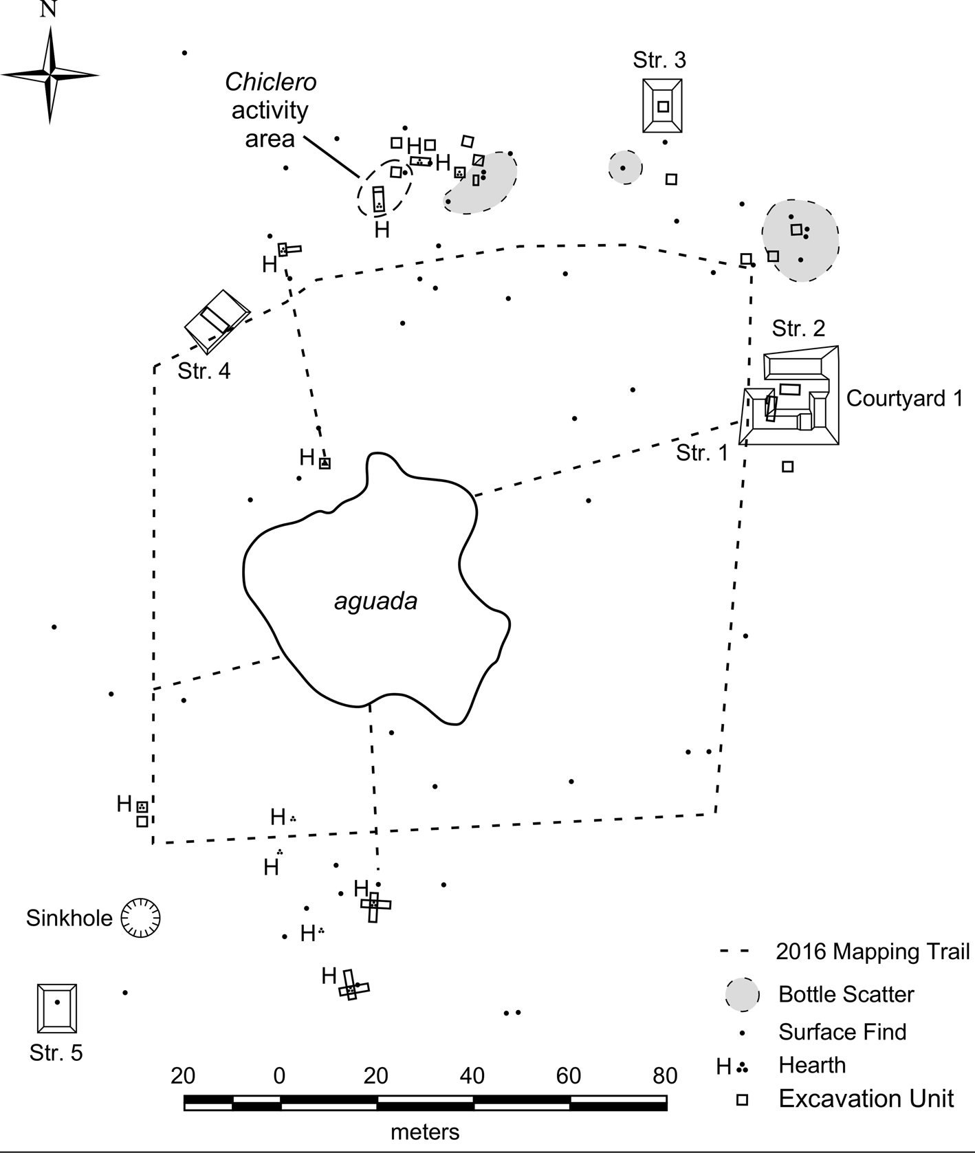
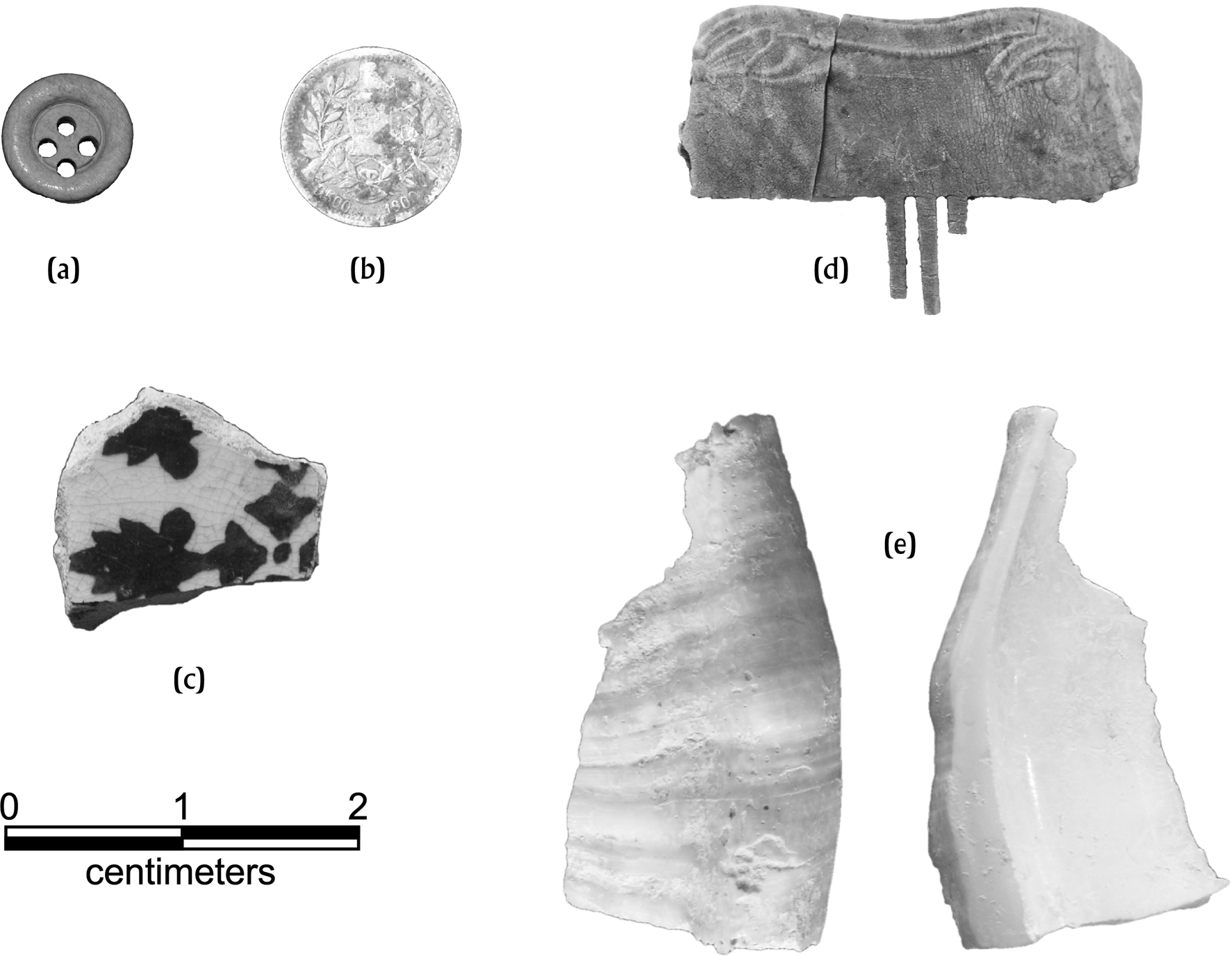
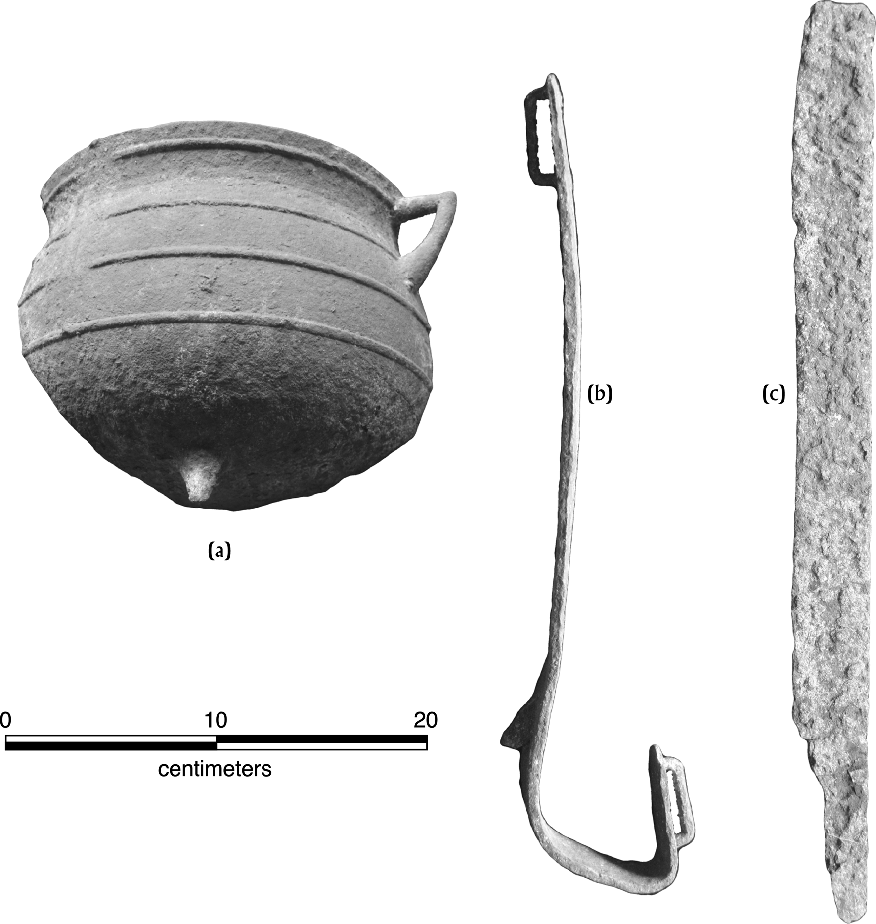
We have reported on the two seasons of archaeological work conducted at Kaxil Uinic in 2015 and 2016 to varying degrees of detail elsewhere (Bonorden Reference Bonorden2016; Bonorden and Houk Reference Bonorden, Houk and Orser2019; Bonorden and Kilgore Reference Bonorden, Kilgore and Houk2015, Reference Bonorden, Kilgore and Houk2016; Harrison-Buck et al. Reference Harrison-Buck, Houk, Kaeding and Bonorden2019). The excavations included 30 individual units, and the investigations documented 66 artifact scatters, 10 stone hearths, and over 5,000 artifacts representing objects of glass, metal, stone, ceramic, shell, and bone (Figures 4 and 5). We interpret each hearth, nine of which are three-stone hearths, to represent individual houses (Bonorden Reference Bonorden2016; Bonorden and Houk Reference Bonorden, Houk and Orser2019). Thompson (Reference Thompson1963:233) described the village as comprising a “score of huts” around the aguada, suggesting our investigations identified about half of the likely structures from 1931. Archival records indicate the village had a cabildo, or courthouse (Conservator of Forests 1930), but we did not conclusively locate this structure during our excavations.
Map of archaeological investigations at Kaxil Uinic. After Bonorden and Houk (Reference Bonorden, Houk and Orser2019:Figure 2).

Personal objects from Kaxil Uinic village. (a) Bone button (KUV2045-01). (b) 1900 Guatemalan ½ Real coin (KUV1508-01). (c) Majolica ceramic sherd (KUV1759-06). (d) Shell comb (KUV1968-01). (e) Shell scoop (KUV2192-01). Photographs by Bonorden.

In some ways, the architectural and artifactual materials at Kaxil Uinic seem to resemble more closely the material culture at the contemporary Maya village at Tikal (James Meierhoff, personal communication 2017) than at the San Pedro Maya villages of Holotunich (Ng Reference Ng2007) or San Pedro Siris (Church et al. Reference Church, Yaeger, Dornan, Liebmann and Murphy2011, Reference Church, Yaeger, Kray and Orser2019; Dornan Reference Dornan2004; Kray et al. Reference Kray, Church, Yaeger, Armstrong-Fumero and Gutierrez2017). The similarity is most apparent in the use of three-stone hearths, which are present at Tikal (Moholy-Nagy Reference Moholy-Nagy2012; Palka Reference Palka2005) and Kaxil Uinic, but absent from Holotunich and San Pedro Siris. James Meierhoff (personal communication 2019) speculates that San Pedro Maya may have settled the village at Tikal but cannot definitively prove it. Unequivocal archaeological evidence at Kaxil Uinic for contact with Guatemala and Mexico is scant but includes a Mexican majolica sherd and a ½ Real coin from 1900 (Figure 5). Rugeley (Reference Rugeley2001:166) reports that the Santa Cruz and Icaiche Maya used Guatemalan currency, so the ½ Real coin could be evidence of contact with Mexico rather than Guatemala.
The archaeological evidence for chicle work at Kaxil Uinic is stronger and includes a concentration of artifacts and features we have defined as a chiclero activity area in the northern part of the village (Bonorden and Houk Reference Bonorden, Houk and Orser2019). This activity area included a three-stone hearth, a machete file, chicle pot fragments, two chiclero spurs, a shotgun stock, machete fragments, and an axe head (Figure 6). We also found chicle pot fragments in other parts of the village, as well (Bonorden and Houk Reference Bonorden, Houk and Orser2019). These discoveries support the archival reports that San Pedro Maya men turned to the chicle industry as a source of income to pay rent to BEC.
Examples of artifacts associated with the chicle industry from Kaxil Uinic village. (a) Chicle pot fragment (KUV1497-01). (b) Chiclero spur (KUV1634-01). (c) Machete blade (KUV1509-01). Photographs by Bonorden.

The archaeological data align well with the general picture of San Pedro Maya life as painted by the archival sources. The villagers acquired goods from both sides of the permeable border and solved the problem of paying rent by engaging in chicle harvesting to interface with the colony's cash economy. In a way, however, this solution to one problem led to another, larger one by providing BEC with and excuse to evict the Maya.
THE BORDER AND THE FATE OF KAXIL UINIC
In 1931, J. Eric Thompson planned to use Kaxil Uinic as a base from which to excavate the nearby ancient Maya ruins of the same name, and the archives at the Field Museum in Chicago contain correspondence and notes related to his scheduled expedition. In a letter dated March 5 of that year, the Colonial Secretary's Office (Reference Secretary1931) requested that the alcalde of Kaxil Uinic allow Thompson's party to stay in the village's cabildo during his project, but when Thompson (Reference Thompson1963:228) reached San José a few days later en route to Kaxil Uinic, presumably with this letter in hand, he learned that BEC had closed the village and relocated its inhabitants to San José. In his memoirs, Thompson (Reference Thompson1963:233–234) described the village as follows:
Kaxil Uinic, near a remote corner of Guatemala, was well situated for getting chicle out of Guatemala without paying export tax, and, in fact, had for many years been a smugglers’ hangout. Also, practically all the chicle legitimately exported from Guatemala had by Easter crossed the frontier, and the excise men had been removed from outlying posts including Chochkitam, nearest chicle station to Kaxil Uinic, so the coast was clear for getting out contraband.
Elsewhere in his memoirs, Thompson (Reference Thompson1963:270) attributes the village's closure to this illicit activity, stating, “Kaxil Uinic had been cleared because it was believed to be a center of chicle smuggling.” Indeed, Thompson's accounts and the BEC's complaints over illegal chicle tapping two decades earlier suggest that smuggling activities along the border may have been a contributing factor in BEC's decision to close Kaxil Uinic and relocate its inhabitants to San Jose.
On the other hand, illicit border activity may have been a convenient excuse more than an actual reason to close the village. Since before the village's founding and until 1931, no one seemed concerned about the movement of people or goods across the border: the San Pedro Maya crossed freely, and even British citizens ignored the border as an impediment to travel. Thompson (Reference Thompson1963:234) crossed into Guatemala from San José, passing through Kaxil Uinic shortly after its closure, over Easter in 1931, noting the frontier was “marked by a straight swathe cut through the forest.”
Thompson (Reference Thompson1939:4) offers an alternative explanation for the closure of Kaxil Uinic in 1931 and the other San Pedro Maya villages in 1936 in his San José report, observing, “the removal was partly the result of friction between the Maya and negro lumbermen of the company, and partly because of damage done to young timber by the villagers in their indiscriminate felling and burning of forest for milpa cultivation.” Separately, the BEC manager, C. S. Brown, reported in a December 1935 campaign speech that milpa burning by villagers at San José, Yalbac, and Kaxil Uinic cost the company $300,000 in losses (Kray et al. Reference Kray, Church, Yaeger, Armstrong-Fumero and Gutierrez2017:67). The timing of the eviction of the San Pedro Maya from the Yalbac Hills region, where they had lived for 80 years, corresponded with the introduction of new hauling technologies ca. 1925, namely gas-powered tractors, that allowed BEC to exploit mahogany farther from rivers than ever before (Camille Reference Camille2000:108). This opened up virgin forests to exploitation; the forests accessible to oxen teams—the previous method for hauling cut trees out of the forest—had all been overcut by 1925 (Camille Reference Camille2000:108). The expanded reach of the logging crews brought them into closer contact with the San Pedro Maya, and Kray et al. (Reference Kray, Church, Yaeger, Armstrong-Fumero and Gutierrez2017:66) note that BEC established a camp next to San José in the early 1930s. Additionally, BEC built “the first modern sawmill” in 1932 in Belize City, which allowed the company to export lumber in addition to logs or squared timber for the first time and changed the economics of mahogany exporting (Camille Reference Camille2000:109).
CONCLUSIONS
The San Pedro Maya at Kaxil Uinic lived outside direct control of the colonial government for nearly 50 years, moving freely across the swathe cut through the forest, which was a purely colonial aspiration, the ephemeral manifestation of an arbitrary line drawn on a map in England—even today, the western border of Belize remains a line of economic and political concern rather than a physical or cultural boundary. Although much of the frontier is lightly populated except near official border crossings, incursions across the border—in both directions—for illegal logging and milpa farming spark tensions, sometimes with tragic outcomes (Associated Press 2016). For nearly five decades, the villagers at Kaxil Uinic essentially had no concern for the border, but ultimately BEC used the border, or more specifically the assertion of illegal activity along the border, as an excuse to close the village and move the residents to San José. The closure was the first step in the systematic removal of the San Pedro Maya from BEC lands, as the Kaxil Uinic immigrants found themselves relocated again in 1936, moved from San José to a reservation south of Orange Walk on Crown lands acquired from BEC (Kray et al. Reference Kray, Church, Yaeger, Armstrong-Fumero and Gutierrez2017:68). The real motivation for the eviction of the San Pedro Maya at Kaxil Uinic, however, appears to have been an economic one, based on mahogany extraction, rather than an actual concern for chicle smuggling (Kray et al. Reference Kray, Church, Yaeger, Armstrong-Fumero and Gutierrez2017). In many ways, BEC's actions toward the San Pedro Maya (as well as British Honduras) mirror actions by the United Fruit Company elsewhere in Central America and underscore the primal role private companies played in state-making and breaking in the region (for example, see Lansing [Reference Lansing2014]).
RESUMEN
Tras huir de la violencia de la Guerra de Castas en México (1847–1901), los mayas de San Pedro ocuparon casi dos docenas de pequeñas aldeas en los bosques del oeste de Honduras Británica y el noreste de Petén desde la década de 1850 hasta la década de 1930. Sin fronteras físicamente delimitadas presentes entre Honduras Británica y sus vecinos antes a fines de la década de 1880, los datos arqueológicos y de archivo demuestran que los mayas de San Pedro se movían libremente a través de los bosques ligeramente poblados del área. Sin embargo, últimamente, la ambivalencia de los mayas de San Pedro hacia la frontera entre Honduras Británica y Guatemala le proporcionó a la Belice Estate and Produce Company (BEC) una excusa para desalojarlos de sus aldeas en la década de 1930. En este artículo, consideramos a las fronteras de Honduras Británica como construcciones políticas, aspiraciones políticas y, finalmente, como líneas físicas que atraviesan la selva. En este artículo, presentamos información del archivo histórico y datos arqueológicos de Kaxil Uinic, un pequeño pueblo maya de San Pedro en Honduras Británica, con el fin de examinar los siguientes temas: el conflicto entre los mayas de San Pedro y sus homólogos coloniales debido a sus diferentes puntos de vista sobre la frontera; la evidencia de vínculos entre Kaxil Uinic y Icaiché, México; y los roles que el contrabando de chicle y la tala comercial tuvieron en el desalojo de los mayas de San Pedro de las tierras de BEC. Los datos del archivo histórico sugieren que los mayas de San Pedro que vivían en Kaxil Uinic instauraron su pueblo previo a que Honduras Británica estableciera su línea fronteriza y creían estar en territorio mexicano. Los archivos históricos sugieren la existencia de una preocupación persistente por parte de británicos y colonos sobre la relación percibida entre los aldeanos en Kaxil Uinic y los mayas de Icaiché, un grupo conocido por sus asaltos a los campos de tala comercial cuando se negaban a pagarles alquiler. La necesidad de pagar alquiler a BEC condujo los mayas de San Pedro a la economía monetaria, y los datos arqueológicos de Kaxil Uinic indican que algunos de los aldeanos participaron en la industria del chicle. A principios de 1900, BEC reportó actividad de chicle ilegal a lo largo de la frontera, y en 1931 Kaxil Uinic ya tenía la reputación de ser un lugar de reunión de contrabandistas de chicle. Usando el contrabando de chicle transfronterizo como excusa, BEC cerró el pueblo en 1931, aunque la verdadera razón de hacerlo parece haber sido basada en una motivación financiera para proteger las operaciones de tala de caoba del BEC.
ACKNOWLEDGMENTS
We would like to thank the Institute of Archaeology, Government of Belize for permitting the excavations discussed here, as well as The Forestland Group, represented my Dr. Alex Finkral and Mr. Jeff Roberson, for granting us permission to excavate on their land. Generous support from the Alphawood Foundation funded our archival work in Jamaica and England. Christina Halperin kindly drew our attention to the similarities between Wray's survey markers and the Maya practice of marking borders as well as to the similarities between the actions of BEC and subsequent colonial actions by other private companies in Central America. We would also like to thank Dr. Tomás Gallareta Cervera, who translated the summary into Spanish. This article benefited from helpful comments from three anonymous reviewers and from Norman Hammond, who tracked down a hard-to-find reference for us.