
Introduction
The ironworking remains at the ancient royal city of Meroe, Sudan (Figure 1) are amongst the most famous in Africa, attracting the attention of archaeologists since the early twentieth century (Sayce Reference Sayce1912: 55). Early fieldwork focused on the excavation of impressive temples and monumental architecture (e.g. Garstang et al. Reference Garstang, Sayce and Griffith1911), rather than the slagheaps that were readily visible across the cityscape. Some of the earlier interpretations of ironworking at Meroe adopted a cultural-historical perspective to explain the diffusion of iron technology across North Africa (e.g. Trigger Reference Trigger1969), although the evidence was comprised largely of iron artefacts recovered from graves, rather than excavated evidence of iron-production technology. Meroe was considered to have played a fundamental role, supplying both iron to Egypt (Sayce Reference Sayce1912: 55; Török Reference Török1997) and knowledge of iron production south into sub-Saharan Africa. Stylistically, Meroitic iron production was likened to Roman smelting techniques (Tylecote Reference Tylecote1982: 41), and was assumed to have been inspired from the north. These models of cultural-historical diffusions of iron production, however, were built on a limited understanding of the archaeometallurgical remains at Meroe.
The location of the royal city of Meroe, at international, regional and site levels (figure by the authors).

Peter Shinnie excavated several large trenches around Meroe starting in 1965. He was the first to undertake systematic excavation of some of the slagheaps (assisted by the archaeometallurgist Ronnie Tylecote), while attempting to gain a wider understanding of the archaeological deposit sequences (Shinnie & Bradley Reference Shinnie and Bradley1980; Shinnie & Anderson Reference Shinnie and Anderson2004). Shinnie's excavations revealed six furnaces and two furnace workshops on the north mound (Tylecote Reference Tylecote1970, Reference Tylecote1982; Shinnie & Kense Reference Shinnie and Kense1982; Shinnie Reference Shinnie, Shinnie and Haaland1985; Shinnie & Anderson Reference Shinnie and Anderson2004: 77–79). Other than these furnace workshops, however, few in situ furnaces have been found at Meroe (see Humphris & Carey Reference Humphris and Carey2016), which is surprising given the visible presence of large slagheaps across the surface of the city.
Further to the mapping and excavation of Meroe undertaken by Shinnie and his team between 1965 and 1984, a subsequent generation of archaeologists continue to investigate its archaeology, which includes the Royal Enclosure and the south mound and Amun temple, focusing on ritual and domestic aspects of the archaeological record at Meroe (Grzymski Reference Grzymski2005, Reference Grzymski, Łajtar and Wlodzimierz2008; Wolf et al. Reference Wolf, Hof and Onasch2008; Mohamed-Ali et al. Reference Mohamed-Ali, Herbich, Grzymski and Hobbs2012). Despite this work, basic but important questions remain about ironworking at Meroe, including: the number, location and distribution of the slagheaps; the detail of the stratigraphic sequence throughout the excavated areas (Shinnie excavated without using contexts); and the relationship of surface to sub-surface metallurgical features and deposits. The chronology of ironworking at Meroe has also remained poorly defined, although it is generally accepted that significant ironworking was practised from the middle of the first millennium BC (e.g. Edwards Reference Edwards2007: 220). Some research has linked the relationship of iron production at Meroe to political control and symbolism (e.g. Haaland & Haaland Reference Haaland and Haaland2007), but this remains speculative due to the lack of slagheap excavation.
Considering the fame of the site, the impressive nature of the slagheaps and the potential relationship between iron production and political power at Meroe, it is surprising that, since Shinnie's work, there has been no systematic study of the ironworking remains within the royal city until now (although for a summary of a short archaeometallurgical investigation in 1992, see Eigner Reference Eigner1996; Rehren Reference Rehren2001). This article addresses some of these fundamental gaps in the understanding of the ironworking deposits at Meroe by providing new information on the distribution across the site of slag and spoil heaps (the latter created by earlier archaeologists). It also offers an interpretation of the deposit sequences related to the ironworking. An attempt is made to integrate these new data with Shinnie's earlier results and to place this evidence within Humphris and Scheibner's (Reference Humphris and Scheibner2017) recent chronology of the ironworking deposits at the site.
The archaeometallurgical landscape of Meroe
Although multiple publications detail the analysis of archaeometallurgical evidence for ironworking, including slags, pyrotechnical infrastructure and iron metal (e.g. Humphris & Rehren Reference Humphris and Rehren2013), relatively little has been written on archaeometallurgical landscapes; exceptions include the relatively intensive fieldwalking techniques, and the combination of remotely sensed topographical data with surface collections for laboratory analysis (e.g. Pryce et al. Reference Pryce, Bevan, Ciarla, Rispoli, Castillo, Hassett and Malakie2011; Hendrickson et al. Reference Hendrickson, Leroy, Hua, Kaseka and Vuthy2017). The question of how to structure investigations to produce systematic samples of ironworking evidence from within a defined survey area, however, remains a significant issue requiring further critical discussion. The approach adopted for this study has been to undertake surface mapping, integrated with sub-surface prospection of the wider cityscape, before the use of limited excavation of target locations.
Surface mapping
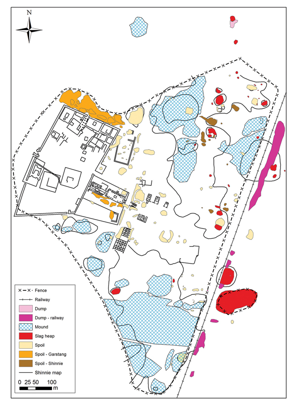
As questions remained about the accuracy and detail of earlier maps (from Shinnie & Kense Reference Shinnie and Kense1982; Shinnie & Anderson Reference Shinnie and Anderson2004), the current project aimed to produce up-to-date coverage of the site. The mapping of slag and spoil heaps is essential for understanding the organisation of the site as a whole, as well as providing a more accurate topographic reference for the archaeological deposits. This remapping of the site used phase differential GPS, total station survey and aerial photogrammetry. Ground-based survey involved mapping the surface extent of visible deposits and features and creating a GIS database of their composition based on surface observation. Through this surface mapping, it became apparent that much of the visible cityscape is a product not only of the original archaeological remains, but also of the activities of archaeologists during the twentieth century. These archaeological investigations have created a number of spoil mounds around Meroe—often located immediately adjacent to the original excavations (Figure 2). These spoil mounds have been identified as those created by Garstang in the early twentieth century, by Shinnie in the mid twentieth century and as other archaeological spoil heaps of unknown origin. These mounds are now an important feature of the cityscape at Meroe and could easily be confused with in situ archaeological remains. Furthermore, the construction of a railway through part of the cityscape has created dumped deposits; there is also a modern rubbish dump to the north of the city (light pink on Figure 2).
The royal city of Meroe, showing Shinnie's original map (Shinnie & Anderson Reference Shinnie and Anderson2004), combined with the results of recent surface mapping (figure by the authors).

Thirty-four slagheaps were recorded. Those investigated further by this project were labelled with MIS (Meroe iron slagheap) numbers; those not subject to further work are unnumbered. The slagheaps vary in size from very small (approximately 4.5m2) through to the largest, MIS4, at 1692m2 (Table 1 & Figure 3). MIS 1–3 were originally recorded as discrete features due to their surface distribution, although recent excavations (Humphris pers. comm.) suggested that these might represent the surface expression of a single larger heap (as depicted in Figure 3). The location of these 34 surface slagheaps is marked with a strong predominance to the east of the royal enclosure. This potentially represents the deliberate positioning of the iron-smelting furnaces in order to avoid possible inundation during the annual Nile flooding, as well as retaining free agricultural land close to the river. Such placement, along with the prevailing westerly winds, ensured that smoke and soot from smelting did not blow into the royal enclosure. A distinct bias in the size distribution of the slag deposits is also evident based on their surface measurements. When the slagheaps are categorised by their visible surface area, the small heaps of less than 200m2 (red) cluster mostly to the north-east of the royal enclosure; the medium-sized (green) slagheaps of between 200 and 1000m2 are scattered from the north mound to the south mound (Figures 1 & 3) of the site; while the large slagheaps (blue) of 1000m2 or greater are to be found to the east of the royal enclosure. This patterning in the spatial distribution of the slagheap categories based on size (i.e. the scale of production remains) requires explanation in terms of chronology, technological organisation or site taphonomy.
Map of the slagheaps at Meroe, colour-coded by their size based on surface expression (figure by the authors).

Slagheap numbers and key dimensions across Meroe (small (red), medium (green) and large (blue), although refer to Figure 3 for further information on the colour scheme).

Sub-surface investigations
Prospection methods were used to investigate the subterranean deposit sequences of a number of the slagheaps identified. The sub-surface surveys used gradiometer data to map the physical extent of the magnetic contrast of the slag deposits and to identify possible furnace locations; such techniques are well established for the investigation of ironworking sites (e.g. Vernon et al. Reference Vernon, McDonnell and Schmidt1998; Carey & Juleff Reference Carey, Juleff, Humphris and Rehren2013). Electrical resistivity survey was also used to investigate the sub-surface sediment architecture of the deposits; other surveys at Meroe have demonstrated the potential of this technique (e.g. Mohamed-Ali et al. Reference Mohamed-Ali, Herbich, Grzymski and Hobbs2012; Humphris & Carey Reference Humphris and Carey2016), although the arid conditions and sand-dominated sediments present challenging conditions for the collection of resistivity data.
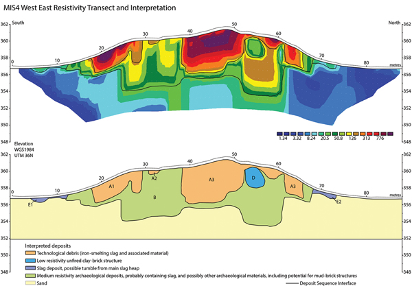
The electrical resistivity surveys employed a Syscal Pro 72 electrode rig, collecting data on a 1m electrode interval using the Wenner Schlumberger array. The results from the resistivity transects demonstrate significant variation in the composition of the slagheaps—an observation supported by subsequent excavations. In particular MIS4—the highest visible slagheap—is composed of slag-based deposits throughout much of its volume; these deposits are labelled A1, A2, A3 and B, as denoted by the higher resistivity values (Figure 4; for the location of the transect, see Figure 3). Although these are substantial deposits of slag, there is a generally lower area of resistivity towards the base of the slagheap (unit B); while this unit may contain some slag material, its sediment architecture is different. It probably includes non-slag-dominated contexts and possibly architectural remains (e.g. mud-brick buildings). A further area of lower resistivity is also visible (unit D) and may represent a possible structure or a deposit with a lower slag content. The results from MIS4 can be compared to the electrical resistivity survey of MIS6 (see Humphris & Carey Reference Humphris and Carey2016), which demonstrates relatively thin deposits of slag overlying an earlier building. The differences in the size and volume of slag deposits between the MIS4 (large slagheap) and MIS6 (medium-sized slagheap) implies a difference in the organisation of the deposition of ironworking waste.
The electrical resistivity section of MIS4 with interpretation of the main components of the slagheap (location of transect shown in Figure 3) (figure by the authors).

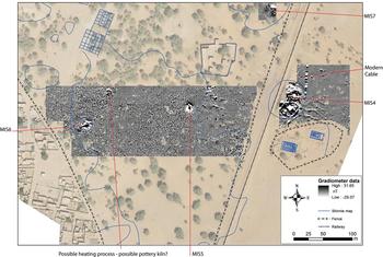
The gradiometer survey employed a Bartington grad 601-2 twin sensor gradiometer, walking 30m grids on 1m traverses and sampling every 0.25m. The gradiometer data spatially defined a number of the slagheaps and also detailed a series of additional surface features across the site, such as a possible pottery kiln or other pyrotechnical structures (Figure 5). Significantly, no new sub-surface slagheaps were identified, although it should be emphasised that gradiometer survey can only penetrate to depths of approximately 1.5m. The north and south mounds at Meroe, however, are deeply stratified, with recorded archaeological stratigraphy reaching depths of up to 6m—as documented by Shinnie during his famous Grid Line 50 excavation (Shinnie & Bradley Reference Shinnie and Bradley1980). Thus, most of the sequence is out of the range of the gradiometry survey. It was therefore necessary to revisit the Grid Line 50 excavation.
Map of the gradiometer data at Meroe, highlighting the slagheaps and a possible pottery kiln or other pyrotechnical feature (figure by the authors).

The Grid Line 50 excavation
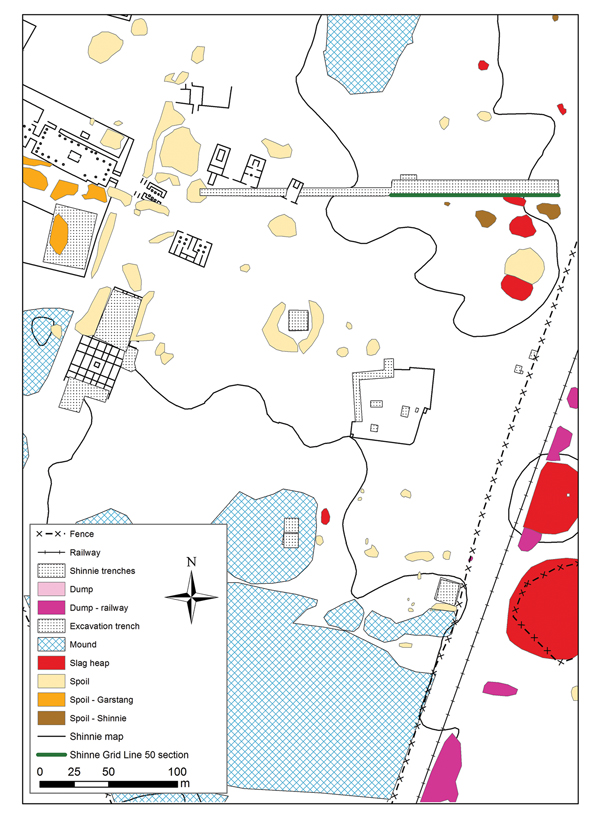
From 1965–1972, Shinnie conducted the so-called Grid Line 50 excavation at Meroe (Figure 6; the reinterpreted section is shown as the green line on his excavation trench). This trench extended 120m from east to west, revealing, among many archaeological finds, substantial sub-surface slag deposits (Shinnie & Bradley Reference Shinnie and Bradley1980). The trench was continued during the 1973–1984 excavations, although this extension is not discussed here, as no significant slag deposits were recorded. The Grid Line 50 trench was excavated using the standard methods of the time, and the results and documentation cannot be directly compared with modern stratigraphic site recording. Some layers—described by Shinnie as ‘episodes’ of activity across the cityscape—were numbered on section drawings; these can be considered broadly equivalent to modern stratigraphic phases. As feature contexts were unrecorded, no cuts or fills are evident in the section drawings, and some ‘layers’ blend into others, with many deposits lacking unique numbers.
The location of Shinnie's Grid Line 50 trench, with the reinterpreted section highlighted in green (figure by the authors).

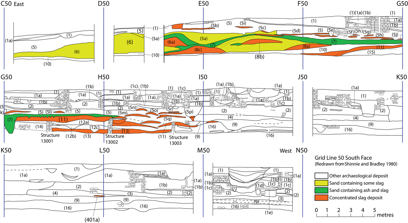
The Grid Line 50 excavation provides an indication of the depth and complexity of the deposit sequence in this area of the city, including the nature and distribution of the subterranean slag deposits. We digitised the section drawing and performed simple stratigraphic analysis through the colouring of different types of slag deposits, according to Shinnie's descriptions (Figure 7). There is a certain degree of simplification of the section presented in Figure 7, and only the layers that are relevant to ironworking are discussed. The reader, therefore, is referred back to the original publication (Shinnie & Bradley Reference Shinnie and Bradley1980) for a more detailed description. Episodes that contain concentrated slag are coloured orange on Figure 7; episodes of slag deposition that also contained ash and sand are coloured green, and sandy deposits that contain some slag are coloured yellow. It is clear that the slag-rich deposits dominate the eastern part of the section, with all episodes of slag-dumping coming to an end between I50 and J50; the western part of the section contained virtually no slag. It is also clear that the vast majority of slag deposits occur towards the middle and base of the depositional sequence in the east, within the earlier stratigraphic deposits.
The reinterpretation of Shinnie's Grid Line 50 excavation, showing three early distinct phases of smelting, before domestic occupation (figure by the authors).

The earliest phase of slag deposition, layer 13, occurs at the base of the sequence, and is above a ‘natural’ soil or early land-surface. This deposit is a long thin spread of slag, extending for approximately 25m, with a maximum depth of around 0.5m. Above this are layers 12a–c, which Shinnie interpreted to represent domestic occupation (Shinnie & Bradley Reference Shinnie and Bradley1980). Above layer 12 are further slag deposits recorded as layer 11—a long, thin spread of slag, similar to layer 13, reaching a maximum depth of approximately 0.75m. Layer 11 is overlain by layer 10, which is described as a water-lain clay representing a hiatus of unknown duration between the two earlier episodes of slag-dumping (layers 13 and 11) and a second, later phase of slag-dumping. This second dumping phase is characterised by a number of medium-sized heaps—labelled by Shinnie as layers 8 and 6—which contrast with the longer spreads of layers 11 and 13 (Shinnie & Bradley Reference Shinnie and Bradley1980). These medium-sized slag dumps have been re-labelled in this analysis as layers 8a–c and 6a, in order to distinguish them as a series of discrete dumps. The nature by which Shinnie's Grid Line 50 section intersects the slag deposits is unknown; does, for example, it clip the end of the heap, or run through its centre? That multiple medium-sized heaps of slag are intersected in the later layers (8a–c and 6a), however, indicates a difference from the earlier phases of activity represented by the longer, thinner layers of 11 and 13, possibly relating to technological organisation of the iron production.
Although no radiocarbon dates are available for layers 8a–c or 6a, and a description of their composition is limited, Shinnie described them as including slag, furnace fragments and tuyeres (tubes through which air is forced into a furnace) (Shinnie & Bradley Reference Shinnie and Bradley1980). Post-dating these is layer 7, described as a sandy material with some slag and ash, and layer 5, a further deposit of ash and sand interpreted by Shinnie as being probably wind-deposited. The layer 5 sand deposit, however, is recorded as containing multiple discrete small dumps of slag, labelled in this reanalysis as layers 5b–r. These deposits are generally smaller than layers 8a–c and 6a, although there is some variation in size (with the caveat that they were exposed in a section that cuts them at an unknown angle). Slag deposits 5b–r represent the last phases of slag-dumping (except for a small deposit in layer 4 (401a)), before a significant shift in the deposit sequence to domestic activity—labelled by Shinnie as layers 1 and 2. He described layer 2 as representing intense domestic occupation, with Meroitic architecture built of sun-dried bricks. Although precise dating for these later domestic deposits and structures (layers 1–2) is unavailable, it can be estimated that they date somewhere between 300 BC (based on the early radiocarbon date from layer 4) and somewhere around AD 200 (based on the early radiocarbon date for layer 1), although these dates are early in the history of radiocarbon dating and should be treated with caution.
This sub-surface slag distribution presents an interesting narrative regarding ancient iron production at the site. Shinnie identified three episodes of iron smelting, labelled as layers 13 and 11, layers 8 and 6 and layer 5(b–r) (Shinnie & Bradley Reference Shinnie and Bradley1980), which sit stratigraphically below the domestic occupation (layers 1–2) of this part of the site. This location, which was used for iron production (assuming the metallurgical debris was dumped close to the production site), was transformed into an area of domestic occupation, and iron production in the immediate vicinity seemingly ceased. A further significant aspect of the section is a series of early structures, labelled here as structure numbers 13001, 13002 and 13003 that appear to be coterminous with the early slag deposits. It is possible that the slag was dumped within an older building (as observed at MIS6). Alternately, these structures could have been designed either to retain the slag, or were originally associated with iron smelting in another way (e.g. the walls of furnace workshops). Re-excavation and recording would be required to explore this further.
Recent archaeological excavations of the slagheaps
Since 2012, excavations have been conducted on seven slagheaps at Meroe (MIS1, MIS2, MIS3, MIS4, MIS6, MIS7 and MIS8; Figure 3). These ongoing excavations involve the systematic collection of archaeometallurgical and archaeological samples for dating and laboratory analysis (for a description of the quantitative sampling, see Humphris & Carey Reference Humphris and Carey2016). Information regarding the depositional sequences of the slagheaps, and the architectural features therein, is integral to understanding the evolution of iron production at Meroe. While this article cannot provide a detailed description of the excavations of these slagheaps (see Humphris & Scheibner Reference Humphris and Scheibner2017), a number of key themes are presented in terms of chronology and formation.
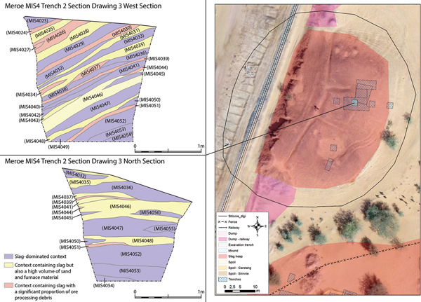
The chronological framework produced from the excavations indicates that iron production was initially conducted within furnaces situated around slagheap MIS4, approximately 1000m to the east of the royal enclosure (Figure 3). Radiocarbon dates for MIS4 provide a date range from 750–130 BC, although these dates cluster in the seven and sixth centuries BC (Humphris & Scheibner Reference Humphris and Scheibner2017: 383). The rate of metallurgical deposition appears to have been significant from c. 700–300 BC—perhaps indicating a particularly high rate of iron production during this early period. This is supported by radiocarbon sequences obtained from MIS2–3, which also indicate significant metallurgical waste produced during Napatan times (c. the mid fourth to mid second centuries BC). Recent excavations at MIS4 show the deposit sequence of the upper 2m of the slagheap to consist almost entirely of iron-production debris (Figure 8), with multiple tipping deposits of slag-dominated contexts; some of these contexts had large quantities of furnace infrastructure, while some had a significant proportion of sand associated with the slag. This near-continuous deposition of slag-dominated contexts in the upper section of MIS4 supports the interpretation of the resistivity data (Figure 4).
Location of the excavations on MIS4 and two sections from trench 2, demonstrating the slag-dominated deposit sequence in the upper part of this slagheap (figure by the authors).

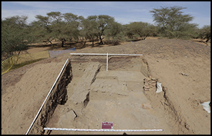
This early period of iron production at Meroe, which seems to have ceased in the eastern part of the site by around the first to second centuries BC, contrasts with the excavation of MIS6. Here, the slagheap was formed over and against an earlier mud-brick building (trenches 2 and 4; Figure 9). This slagheap has a much smaller mass of metallurgical debris compared to MIS1–4. The iron production at MIS6 has been dated from the remains of a furnace workshop found within it to the Late/post-Meroitic period; an in situ hearth and furnace provide dates of c. AD 400–430 for the final workshop phase (Humphris & Scheibner Reference Humphris and Scheibner2017: 391). The entire spread of radiocarbon dates from slagheap MIS6 provide a range of AD 200–520, although these cluster towards the fourth century AD. A similar interpretation is suggested for the unexcavated MIS5, due to its small size and location at the top of the south mound (Figure 3). MIS8, located on the north mound, has been recently radiocarbon dated to the Late/post-Meroitic period (unpublished results from recent radiocarbon dating). A similar situation is encountered at Hamadab, where Late/post-Meroitic iron-production waste overlays earlier Meroitic settlement (Humphris Reference Humphris2014).
Photographs of iron slag piled over the top of an earlier building at MIS6, contrasting with the top of MIS4: top right) MIS6 trench 2; bottom right) MIS6 trench 4 (photographs by the authors).

Integrating the new excavation data with the results of the surface survey highlights an important aspect of the history of iron production at Meroe. MIS1–4 are the result of extensive iron smelting, which took place predominantly in the Napatan and Early Meroitic periods. The slag deposits at MIS6 (and probably MIS5 by virtue of its stratigraphic position on top of the south mound) and MIS8 date to the Late/post-Meroitic period. Where, then, are the slagheaps and furnaces associated with the Meroitic period (c. 300 BC–AD 300)? As Humphris and Scheibner (Reference Humphris and Scheibner2017: 400) note, there is currently a minimum gap in the date ranges for the slagheaps of at least 200 years falling precisely in this period.
An emerging model
Three lines of evidence concerning ironworking at Meroe have been presented: 1) the mapping and categorisation of the distribution of slag deposits visible on the surface; 2) a re-interpretation of Shinnie's Grid Line 50 excavation to understand the sub-surface slag deposits; and 3) evidence from our current archaeometallurgical investigations of a number of the slagheaps. Combined, these results provide an emerging understanding of iron production at Meroe, although significant further research is still required. The iron furnaces at Meroe were positioned consistently to the east of the royal enclosure. The surface mapping clearly demonstrates variation in the size of the slagheaps visible on the ground surface, and in their distribution across the city. The difference in apparent size, combined with recent dating evidence from current excavations, indicates that the most extensive slag depositions at Meroe occurred during its earliest periods (although the limited extent of excavation within the city provides an important caveat). This interpretation, however, is corroborated (for the north mound, at least) by the extensive early slag deposits visible in Shinnie's Grid Line 50. If these deposits are indeed representative of the sub-surface deposit sequence in the north mound and/or the south mound, then the scale of production during this early period was considerable. The recent excavations and associated radiocarbon dating of MIS1 also support this model of large-scale iron production during this early period. One possible stimulus for such large-scale iron production at this time was the supply of the Kushite armies with weapons to support their territorial conquest and defence. Although it is beyond the scope of this article to consider the scale of production in relation to the broader, evolving social, economic and political circumstances of Kush, the reader is referred to Pope (Reference Pope2014) and Török (Reference Török2015). Indeed, Meroe was an important and valuable economic centre for the Kingdom of Kush during the Napatan period (Pope Reference Pope2014: 5–33)—not least due to its capacity to produce large and essential quantities of iron.
The data presented support the hypothesis that at c. 200 BC, iron production came to an end at its traditional locations in Meroe. The accumulation of metallurgical debris at slag mounds MIS1–4 ceased, following which domestic architecture (documented by Shinnie & Bradley Reference Shinnie and Bradley1980) was built atop the slag deposits. This was clearly a deliberate choice, and why it occurred and to where production moved are important research questions. The change in location of the archaeometallurgical remains certainly seems to reflect a development of the urban landscape to the east of the site, which expanded to replace the traditional iron-production locations. These were possibly forced to move in order to accommodate the urban development of the city. This is evidenced not only by the domestic archaeology seen in Shinnie's excavations, but also at MIS1–3, upon which temples were constructed. Thus, the domestic and religious development of the city seems to have taken precedence—a change also associated with impressive imported goods, testifying to a prosperous city (Török Reference Török2015).
If this model addresses the ‘when and why’ of the shift in iron-production locations, the question remains as to where the iron producers moved. The surface mapping undertaken for this study highlights the presence of small slag mounds to the east and north-east of the royal enclosure. The Grid Line 50 excavation also recorded a third episode of iron production represented by smaller slag deposits (5b–r), beneath the later domestic occupation. These smaller slag deposits may indicate that iron production was decentralised in comparison with earlier times, and that the scattering of smaller mounds represents a new freedom for the smelters to have their own discrete workshops. It is possible that during the period when Meroe was the capital of Kush (early third century BC to the mid fourth century AD), iron production continued on the peripheries of the city in small workshops, with the north and south mound becoming home to many of the non-elites—as suggested by the later domestic occupation in Shinnie's Grid Line 50 section (Shinnie & Bradley Reference Shinnie and Bradley1980). It is also clear that iron production took place in the post-Meroitic period (c. AD 300–600), with the surface slagheaps of MIS6 and MIS8 being formed during this time. Whether there was continuity of iron production from the earlier phase, however, remains to be established.
The question also arises as to exactly why the large slagheaps, such as MIS4, were created during the earlier phases of iron production; such a large mound must have been the product of multiple furnace workshops. Although centralised organisation is one mechanism, why expend such effort to walk up the slagheaps and dump material on top of them, rather than simply scattering the debris around the landscape? These earlier mounds were created deliberately over hundreds of years; the metallurgical remains in Shinnie's Grid Line 50 also display this same pattern of continual dumping at a defined location. Excavations at MIS1–3 have revealed the presence of multiple slagheaps, which were then incorporated into one large mound. It appears that this earlier desire to make large slagheaps lapsed, possibly indicating the changing organisation of the iron-production process.
Conclusions
This article has presented interpretations of newly generated data regarding the iron-production remains found at the royal city of Meroe. The integration of surface mapping, reanalysis of Shinnie's Grid Line 50 trench and data from more recent excavations has provided a greater understanding of the metallurgical remains at Meroe. In particular, it appears that the earliest phase of the site (c. 700–300 BC) contains the largest volumes of iron-production waste, curated into large slagheaps. Following this phase, domestic and ritual development of the cityscape took precedence, coupled with the seemingly more scattered distribution of smaller iron-production areas across the north and south mounds. This switch in the nature of slag deposition is interpreted as a change in the organisation of iron production, which possibly became less ‘centralised’ over time.
The data presented here contribute to only the first step in constructing a model of iron production at Meroe. In particular, systematic excavation of some of the smaller slagheaps is planned in future seasons. These slagheaps have so far witnessed little archaeological investigation, the larger- and medium-sized slagheaps having been the focus of excavation due to their greater visibility across the city. Secondly, the lack of evidence for iron production from c. 300 BC–AD 300 requires further explanation, although the investigation of some of the smaller slagheaps might fill some of this chronological gap. Another avenue of future research is to use other electromagnetic techniques to detect sub-surface concentrations of slag. This would provide the basis for a more complete analysis of the distribution of slag deposits across Meroe. It is hoped that this planned future research will provide greater detail on the chronological and spatial organisation of ironworking at Meroe, in order to understand with greater clarity the role of Meroe and its role in iron production along the Nile corridor.
Acknowledgements
We thank the National Corporation for Antiquities and Museums (NCAM) in Sudan for supporting and assisting the UCL Qatar research at Meroe, most notably Abdelrahman Ali and El Hassan Ahmed. The contribution of the NCAM inspectors who worked as part of the team during the surveys and excavations is gratefully acknowledged. We also gratefully acknowledge the support of the University of Khartoum. The research presented here is funded by the Qatar-Sudan Archaeology Project (grant 037) through the support of UCL Qatar (Qatar Foundation). Most importantly, thanks are given to all of the project team for their hard work in the field. Finally, we thank the reviewers for their comments and suggestions to help improve this manuscript.