The expedition
The Austro-Hungarian north pole expedition of 1872–1874 was the brainchild of the German geographer and promoter of arctic exploration, August Petermann. Immediately prior to that expedition he had been largely responsible for the first and second German north pole expeditions of 1868 and 1869–1870, both aimed at exploring the east coast of Greenland, with a view to trying to reach the pole via that route. In the first case the expedition under Captain Carl Koldewey, in the ketch Grönland was blocked by ice from reaching the Greenland coast, and thereafter had no better luck in trying to reach Gillis Land in Svalbard (Koldewey and Petermann Reference Koldewey and Petermann1871). The latter island (in fact Kvitøya) had been seen from a distance by the Dutch whaler Cornelius Giles in 1707 (Conway Reference Conway1906) but had not been explored. The second German north pole expedition on board Germania and Hansa (Captains Carl Koldewey and Paul Hegemann respectively) managed to reach the east Greenland coast, but had little success in pushing towards the pole (Koldewey Reference Koldewey1874). Germania wintered off Sabine Ø, but Hansa became beset in the ice and was ultimately crushed, although her crew managed to reach the Danish settlements in west Greenland.
Following these failures, Petermann argued that a more promising line of attack, in terms of trying to reach the pole, would be via the area between Svalbard and Novaya Zemlya where, he assumed, the northward flowing waters of the Gulf Stream (or more correctly its continuation, the North Atlantic Drift) would ensure an ice-free embayment extending much farther north than elsewhere (Payer Reference Payer1876 1: 82–83).
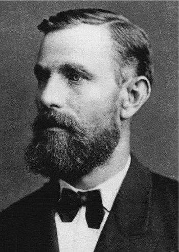
Petermann proposed mounting a trial expedition, a reconnaissance in effect, in the summer of 1871, and recruited two individuals to lead it. One of these was Lieutenant Carl Weyprecht (Fig. 1) of the Austro-Hungarian navy (Petermann Reference Petermann, Berger, Besser and Krause1871). Carl Weyprecht was born on 8 September 1838 in Darmstadt, Hesse, in Germany. He wished to pursue a naval career but since Hesse had no navy, in 1856, he enrolled as a sea-cadet in the Austrian naval academy in Trieste (Koerbel Reference Koerbel and Nuttall2005a). During the Austro-Prussian War he served with distinction on board the battleship Drache in the pivotal Battle of Lissa against the Italians, who were allied with the Prussians, in the Adriatic on 20 July 1866, and was awarded the order of the Iron Cross III.
Carl Weyprecht (Photo: Vienna: Bildarchiv der Österr. Nationalbibliothek).

While in the Caribbean on board the corvette Kaiserin Elisabeth, in connection with plans to rescue Emperor Maximilian of Mexico, Weyprecht contracted malaria at Veracruz. For a time his life was in danger but he made at least a partial recovery in hospital in Havana, Cuba (Berger and others Reference Berger, Besser and Krause2008: 12). But by 2 April 1868 he was back in Vienna.
Prior to Weyprecht's illness Petermann had offered him the position of scientific officer and second-in-command of the first German polar expedition aboard Grönland, planned for the summer of 1868. Carl Koldewey was appointed to the command of the expedition (Koldewey and Petermann Reference Koldewey and Petermann1871) but to Weyprecht's great disappointment, Koldewey countermanded Petermann's offer to Weyprecht to handle the scientific programme, in part on the grounds that he had still not fully recovered his health. Later, Weyprecht was again engaged in discussions with Petermann about becoming involved in the second German polar expedition, on board Germania and Hansa but, unfortunately for Weyprecht, Petermann arguedwith Koldewey (who was also to command this expedition) and with the Bremen Polar Society which was organising the expedition. Hence Weyprecht was again passed over. By the time Petermann again approached him with an invitation to lead his reconnaissance expedition of 1871. Weyprecht's health had improved, and he gladly accepted the invitation.
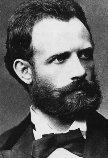
The other expedition leader was Lieutenant Julius Payer (Fig. 2) of the Austrian army. Born on 2 September 1841 in Schönau near Teplitz (now Teplice in the northwestern part of the Czech Republic), he attended the Theresian Military Academy in Wiener-Neustadt (near Vienna) from 1857 until 1859 (Koerbel Reference Koerbel and Nuttall2005b). He was decorated for his bravery in the Battle of Solferino in 1858 and in the Battle of Custozza in 1866. Between 1864 and 1868 he was also engaged in exploring and mapping the Ortler Alps in what is now northern Italy, making 30 first ascents. On the basis of this experience he was invited by Petermann to take part in the second German north pole expedition, as topographer, on board Germania, and took part in that expedition's main sledge trip north from the winter quarters on Sabine Ø as far as Kap Bismarck on Germania Land (Koldewey Reference Koldewey1874).
Julius Payer (Photo: Vienna: Bildarchiv der Österr. Nationalbibliothek).

For the reconnaissance expedition of 1871 Petermann made available 2000 taler from funds left over from the second German north pole expedition and Emperor Franz-Josef added a further 500 taler. The bulk of the remaining funding was contributed by government departments and corporations (Berger and others Reference Berger, Besser and Krause2008: 25). Plans were well under way for the reconnaissance expedition when Payer happened to be dining with Count Hans Nepomuk Wilczek, who became extremely enthusiastic about the impending expedition, and offered to sponsor the main expedition the following year, and to provide funding to the tune of 30,000 gulden (Berger and others Reference Berger, Besser and Krause2008: 317), later increased to 52,000 gulden (Slupetzky 1995).
Weyprecht travelled north to Tromsø in May 1871 and chartered a small, new, ice-strengthened schooner, Isbjørn (Weyprecht Reference Weyprecht, Berger, Besser and Krause1871a). He also hired a captain, Captain Johan Kjeldsen and a crew of eight: a harpooner, four sailors, a carpenter, a cook and a ship's boy, all Norwegian (Payer Reference Payer1876 1: 84).
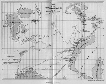
Isbjørn put to sea from Tromsø on 20 June (Fig. 3), and encountered the first ice on 28 June, to the south of Bjørnøya. Two days later the ship became beset for ten days. After working her way east along the ice edge, on 22 July she headed back west to just slightly beyond Sørkapp, on Spitsbergen. Then, unable to make any significant progress northwards in Storfjorden Isbjørn headed back east, repeatedly probing the ice edge, to just beyond Hopen. She made her highest latitude (78° 38′N) on 31 August; Novaya Zemlya was sighted later but foul weather prevented any landings. By 4 October the expedition was back at Tromsø. It had not even come close to reaching Gillis Land [Kvitøya].
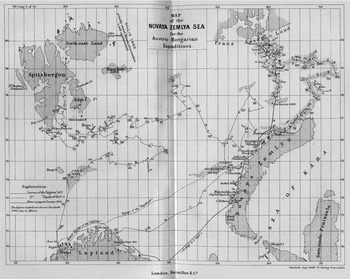
Map of the routes of the Austro-Hungarian expeditions of 1871 (in Isbjørn) and 1872–1874 (in Tegetthoff) and of the retreat by sledge and boat (Payer Reference Payer1876 I: following xxxi).
One of the main conclusions that Weyprecht reached from this experience was that their inability to attain a higher latitude was due to the lack of commitment on the part of the Norwegian crew. As he complained to Petermann:
Our voyage has been a very difficult one for me. You wouldn't believe what tact was required to overcome the difficulties that a Norwegian captain and a lazy crew can place in one's way. Never support such an expedition again, dear Doctor. Nine times out of ten you would be throwing your money into the water to no purpose (Weyprecht Reference Weyprecht, Berger, Besser and Krause1871b: 334–335).
This experience with the Norwegian crew of the Isbjørn led directly to the crew of the expedition vessel for the main expedition in 1872–1874 being entirely Austro-Hungarian.
This was not the only major decision that emerged from the 1871 voyage. It was decided that a steamer was essential for the main expedition and since, through Wilczek's generosity, and Payer's and Weyprecht's diligent fund-raising activities, funding was not a major problem, it was decided to build a specially designed vessel. That vessel, named Admiral Tegetthoff (after the victor of the Battle of Lissa) was ordered from the Tecklenborg yard in Bremerhaven (Berger and others Reference Berger, Besser and Krause2008: 13). Weyprecht spent most of the winter of 1871–1872 in Bremerhaven, supervising the building of the ship. She was launched on 13 April, a bark-rigged steamer of 220 tonnes, with a steam engine of 100 hp. The engines had been built at Stabilimento tecnico Triestino in Trieste (Krisch Reference Krisch1875). She ran her trials on 8 June (Payer Reference Payer1876 I: 122).
Tegetthoff put to sea from Bremerhaven on 13 June 1872 (Payer Reference Payer1876 I: 121). Her complement totaled 24: Schiffsleutnant Carl Weyprecht, Oberleutnant Julius Payer, Schiffsleutnant Gustav Brosch, Schiffsfähnrich Edward Orel, medical officer Dr. Julius Klepes (a Hungarian), engineer Otto Krisch (who had supervised installation of the ship's engines), bosun Pietro Lusina (an Austrian merchant captain who had signed on as bosun, in order to take part in the expedition), a carpenter, a stoker, 11 seamen (all from Fiume (now Rijeka) and area, and two hunters from St. Leonhard in Passeier in the Tyrol (now San Leonardo in Passiria in northern Italy), Johan Haller and Alexander Klotz. Payer had employed Haller during his surveys in the Ortler Alps between June and October 1868. When Payer wrote to Haller to invite him to join the expedition, in February 1872, he asked him to find another suitable jäger. Haller then recruited Klotz (Haller Reference Haller1959). Captain Elling Carlsen would join the ship, as ice-master and harpooner, in Tromsø. The latter had many arctic voyages to his credit, mainly for hunting walrus, and in the previous year he had discovered Barents's wintering site at Ledyanaya Gavan’ (Icy Harbour) in northeastern Novaya Zemlya (Holland Reference Holland1994: 285). Also on board were eight dogs, six from Vienna and two from Lapland. All orders on board were given in Italian (the language of the crew, who spoke a Venetian dialect), but other languages in regular use were English, German, Slovenian and Hungarian.
The ship reached Tromsø on 3 July, but replenishing bunkers and repairing a leak delayed her departure until 13 July, when she headed north into the Barents Sea (Payer Reference Payer1876 I: 125) (Fig. 3). The objective was to round Novaya Zemlya on the north and, if possible, to attempt the northeast passage to Bering Strait. If ice conditions were particularly favourable, an attempt at the north pole was not excluded. The first ice was encountered on 25 July, at 74° 0′ 15″ N, that is less than 170 nautical miles (315 km) north of Nordkapp. This was not a good omen. The ice became steadily closer as Tegetthoff worked her way north, although she was temporarily beset for a few days (29 July until 2 August). By 7 August she was off Poluostrov Admiral'teystva [Admiralty Peninsula], and on 12 August off the Ostrova Pankrateva [Pankratev Islands] encountered a schooner which was flying the Austro-Hungarian flag; this was Isbjørn, again under the command of Captain Kjeldsen. She had been chartered by Count Wilczek (who was on board), and was on her way to establish a depot on the north coast of Novaya Zemlya, to which Tegetthoff's crew would be able to fall back in case of emergency. The two vessels continued north in company, and next day (13 July) Tegetthoff's crew assisted that of Isbjørn in sledging the fuel and provisions ashore across the fast ice and establishing a depot on one of the Ostrova Barentsa (Barents Islands). The site was easily distinguished by three conspicuous rock outcrops known as the ‘Drei Sarge’ [Three Coffins]. On 20 August the two vessels separated and Tegetthoff headed north. But on the very next day (21 August), at 76° 22′N; 63° 3′E, off Russkaya Gavan’(Russian Harbour), she became solidly beset. She would not move under her own steam again.
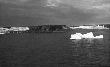
The ship drifted with the ice, initially northeastward until 2 February 1873, when the drift changed to generally westward through the spring and summer. But then on 1 August the drift changed again to generally northward. Then, around noon on 30 August 1873, land was sighted in the distance to the northwest. It was named Zemlya Frantsa-Iosifa (Franz Josef Land). The ship continued to drift, somewhat haphazardly as to direction, until the end of October, when she found herself beset in the fast ice at 79° 58′N, off the south coast of an island that was named Ostrov Vil'cheka [Wilczek Island] (Fig. 4). Several brief trips were made ashore in early November, but then the onset of the winter darkness meant that any longer exploring trips would have to be postponed until the spring of 1874.
Cape Wilczek, Wilczek Island. Krisch's grave lies at the foot of the cliff. (Photo; Heinz Slupetzky).

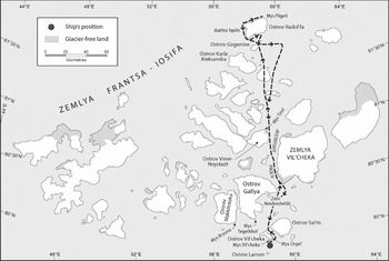
Weyprecht, Payer and the officers and men then settled down, no doubt somewhat impatiently, for a second winter. In the spring three sledge trips were mounted to explore as much of the unknown landmass as possible. In each case the sledge parties were led by Payer, while Weyprecht remained in command of the ship. The first sledge trip was quite short, lasting only from 11 until 15 March. The party consisted of Payer and six men (including Haller and Klotz), with three dogs. They sledged past the west side of Ostrov Vil'cheka to Mys Tegetkhof [Cape Tegetthoff], the southern tip of Ostrov Gallya [Hall Island] and explored Zaliv Nordenshel'da [Nordenskiöld Fjord] and, briefly the Lednik Sonklar [Sonnklar Glacier] (Fig. 5 and 6).
Modern map of Franz-Joseph Land, showing route of Payer's major sledge trip.
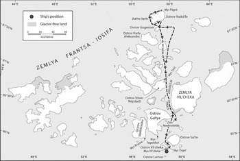
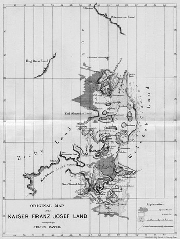
Payer's map of his sledging journeys on Franz-Joseph Land (Payer Reference Payer1876 II: following xiv).
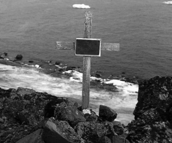
On the day after they returned to the ship the engineer, Otto Krisch, died. He had displayed the first symptoms of tuberculosis as early as February 1873 (Krisch Reference Krisch1875), and then in early February 1874 he also showed the first signs of scurvy. He had lain in a coma for two weeks prior to his death (Krisch Reference Krisch1875). He was buried in a deep crevice in the rock at Mys Vil'cheka [Cape Vilczek] on the shores of Ostrov Vil'cheka on 19 March (Payer Reference Payer1876 II: 72); a wooden cross with a brass plaque, giving his details, was erected over the grave (Krisch Reference Krisch1875) (Fig. 7).
Otto Krisch's grave. (Photo: Heinz Slupetzky).

Payer's next sledge trip was remarkable not only for its length (almost a month) but also for the fact that given the relatively late date, and the general ignorance of the ice regime in this area, Payer and his men were constantly haunted by the fear that ice break-up might occur, and that the ship might drift away, before they returned. At the same time, if the ship were still there when they returned, this meant that it would probably remain beset throughout the following summer and that they would be faced with a sledge-and-boat trip south to safety, a daunting prospect. Accompanied by six men (including Haller and Klotz) Payer set off on 26 March and headed north between Ostrov Vil'cheka and Ostrov Sal'm [Salm Island], then on northward between Ostrov Gallya and Zemlya Vil'cheka [Wilczek Land] (not to be confused with the much smaller Ostrov Vil'cheka), into the southern reaches of the major north-south channel, Avstriyskiy Proliv [Austrian Strait], which provides access to the eastern part of the archipelago. Surveying as he went (and climbing to suitable vantage points on various islands for this purpose), Payer pushed steadily north. At Mys Shretter [Cape Schrötter] on Ostrov Gogenloe [Hohenlohe Island], to achieve greater speed he decided to split his party (Haller Reference Haller1959). Leaving Haller, Sussich and Klotz (who had an injured foot), he himself pushed on with Orel and Zaninovich on 9 April. As Payer and party climbed the Lednik Middendorfa [Middendorf Glacier] on Ostrov Rudol'fa [Rudolph Island], an accident occurred which allowed Haller to show his mettle as an experienced alpine climber. Payer and party had been travelling unroped, when Zaninovich, the sledge and the dogs fell down a crevasse. Payer himself barely escaped. He then raced back to Mys Shretter to fetch Haller. The latter brought a climbing rope, abseiled down into the crevasse, and rescued Zaninovich, the dogs and the sledge (Haller Reference Haller1959).
On 12 April Payer and party reached Mys Fligeli [Cape Fligely] at 81° 45′ 59″N, on Ostrov Rudol'fa (Payer 1886 II: 162). This is the northernmost tip of the archipelago, but Payer was convinced that he could see further islands to the northwest (which he named King Oscar Land) and to the north (Petermann Land), that he estimated to lie 60–70 miles (100–115 km) away. These must have been either cloud formations, or miraged hummocks, since no land exists there.
Starting back south on the very next day (13 April), Payer and his men were enormously relieved when, on rounding Mys Orgela [Cape Orgel] on Ostrov Vil'cheka on 22 April, they sighted the ship, still lying beset in the ice where they had left her.
This sledge journey represents a very creditable feat of arctic exploration. In 27 days Payer and his men had sledged a minimum of 230 nautical miles (425 km). Payer had been surveying assiduously throughout, and this inevitably had demanded some quite lengthy halts. The names he bestowed on the islands, headlands, bays, straits etc. represent a permanent memorial to his diligence: names such as Ostrov Viner Neystadt [Wiener Neustadt Island], Mys Tirol [Cape Tyrol], Ostrov Gogenloe [Hohenlohe Island], Bukhta Teplits [Teplitz Bay]and Ostrov Carla Aleksandra [Carl Alexander Island]. He made a significant error in assuming that the islands he could see to the west of his route were simply headlands of a larger landmass, which he named Zichy Land. In addition, given that the visibility was often limited while he was surveying, and since the snow cover on the land made it difficult to distinguish between land and sea ice, the shapes of the islands, and the relative distances between them are in many cases somewhat inaccurate. Nonetheless this was a very commendable effort.
A week after this important sledge trip, Payer set off again on a third, short sledge trip, on 29 April. Accompanied by Brosch and Haller he sledged to Mys Bryuna [Cape Brün] on Ostrov Makklintoka [McClintock Island]. Ascending the Lednik Simony [Simony Glacier] they reached the summit of Mys Bryuna, from where Payer took a round of angles. They were back on board the ship by 3 May (Payer Reference Payer1876 II: 208).
By this point it had been decided that there was no alternative but to abandon the ship and to head south. For the following ten days, the entire focus was on preparations for what clearly would be a very challenging trip. Initially three boats were taken, these being mounted on solidly-constructed, low sleds. Each was hauled by a group of seven men, commanded by Weyprecht, Payer and Brosch. In addition provisions, equipment, clothing etc. were hauled in three separate sledges. The weight on each sledge was approximately 1800 lbs (820 kg), and the amount of provisions and equipment was calculated to last 3–4 months (Carlsen Reference Carlsen1875: 62).
Thus the boat-sledges would be hauled forward for a convenient distance, then the crew would walk back to bring forward their second sledge. Rather than tents that were pitched on the ice every night, tents were rigged on the boats, and the men slept fully clothed, in these somewhat cramped quarters. Later it was decided to relieve the cramped quarters in the boats, by sending a party back to the ship to recover a fourth boat. The group thereafter was divided into four parties, Carlsen being in charge of the fourth one. A small dog sledge was also used, for making short, relatively fast excursions.
Weyprecht's journal of the retreat, 15 May until 3 September 1874
The journal is preserved in the Österreichisches Staatsarchiv in Vienna (Weyprecht Reference Weyprecht1874a) and is reproduced along with much relevant information is available in the book by Berger and others (Reference Berger, Besser and Krause2008).
Plan for the boat voyage. Our route will be straight south, as far as possible. In any deviations from this course in general it will be better to hold to the west rather than to the east, since in the former direction we can expect more broken ice. Our first goal is Wilhelm Island (75° 53′E).Footnote 1 If the boats reach it before the middle of August, and they still have 10 days’ provisions in hand, the provisions depot at the Three CoffinsFootnote 2 will be left untouched and the voyage will be continued along the coast to Matochkin Shar without stopping. If we reach the coast of Novaya Zemlya only after the Norwegian and Russian ships have left it, after renewing our provisions at the Three Coffins, we'll have to follow the coast to Goose Land [Gusinaya Zemlya] (72°) and from there begin the crossing via Kolguev Island [Ostrov Kolguev] to the White Sea. In case of extreme necessity we'll be able to winter on this island which is inhabited by Samoyeds. These plans are also binding, in the event that the boats become separated.
The most careful attention is to be paid to avoiding the latter situation. The normal situation will be that even under favourable circumstances the boats should never be out of hearing range of the signal horn from each other, and the leading boats will always be responsible for adhering to this instruction.
If, despite this the boats become separated, on touching first at the southern tip of Wilhelm Island then at the northern tip of Admiralty Peninsula [Poluostrov Admiral'teystva], messages are to be deposited under a cairn, then each boat is to continue its voyage independently according to these arrangements.
Each morning, provisions will be distributed by Lieutenant Orel, Dr. Kepes and Bosun Lusina for each party for breakfast and supper. Lt. Brosch will make the calculations about provisions. One man from each boat's crew will function daily as cook.
It must be strictly ensured that no disorderliness is allowed to develop in the boats. Every day before starting the men are to wash and to stow their bundles, rolled up with their night things, under the seats.Footnote 3 Only those who have been given permission by the respective boat's commanders will be allowed to shoot. All the shot is to be reserved for the open-sea voyage. All other details will depend on circumstances.Footnote 4
15.5. Fair weather. Observations discontinued; journals wound up and packed.Footnote 5 I'm still continuing my attempts with the oil lamps, but the heat at the wicks is too great; they become charred too far down and then no longer draw up any oil. Orel has not been in the best of health for a few days. Brosch set up a new stake in order to get a longer baseline facing the western mountains. The snow is already very soft; one sinks to halfway up one's calves. It will be heavy going for us with the enormous weights, but we can't set off before 20 May, since otherwise the provisions will run out before the period that is most favourable for the trip with the boats. Today Carlsen was inebriated. From what? From the alcohol in which his zoological collections ought to have been packed.
16.5. Thermometer to +2°. The snow soft. The boats are now fully equipped.
17.5. Mild weather. Sunday rest. Was on shore and deposited under the cairn on Cape Wilczek [Mys Vil'cheka]Footnote 6 a document with the details of our departure and a minimum thermometer. The thermometer is stuck in a wooden case which is tied to the stake standing in the cairn, and covered with about 6 inches of rocks in such a way as to allow air circulation.Footnote 7 The snow is already very soft so that walking is very tiring. Stiglich's injury is completely closed today.
18.5. ENE wind with light drifting snow. Had all 8 sledges and boat-sleds thoroughly polished; the large hatch caulked.
19.5. A stiff ENErly with heavy drifting snow. The boat-sled runners given their last check and polished with soap. Instructions issued for officers and men.Footnote 8
20.5. A bright morning. Finishing touches added to the boats. A short trial trip revealed that both the sledges and the boats can easily be hauled by 7 men. Left the ship at 8.30 in the evening. The flags hoisted on the boats; the ship's flag nailed to the topmast. Only a few paces from the ship the going was already so bad that we had to harness 10 men to each boat, and even then we could advance only with the greatest difficulty. With every step one sank to over one's knees.Footnote 9 The snow is like pure sand; the boat-sleds slide somewhat better, but the sledges dig into the granular snow so badly that in places they have to be partly unloaded. The dogs are of no help at all when harnessed to the sledges; on the other hand, harnessed to their own small sledge they can haul 200 lbs.Footnote 10 To move everything ahead three trips have to be made. Under these circumstances by 3 o'clock (on 21.5) we had covered only  mile,Footnote 11 with a break of 1
 hours. The men have no appetite; they are too thirsty. So nothing but unexpectedly slow progress and problems.
21.5 p.m. Slept or rested with varying degrees of success until 4 p.m. The temperature was very pleasant. Furs and a blanket were quite sufficient.
22.5 a.m. North wind, −5°R.Footnote 12 Broke camp at 6 p.m.; worked till 11 then rested till 1, then hauled again until 5.00. No porter in the world works for 8 hours so strenuously as we. In places the going is atrocious; the sledges often have to be half unloaded. For almost half the time the men have to haul at the word of command, in order to advance in jerks. We are now somewhat beyond the southern end of the baseline; p.m. −5°R. Wakened at 5 p.m. Had slept well, not very hungry but tormented by thirst, mainly while and after working. Melting snow in one's hand and licking up the drops. Payer went back aboard with ZaninovichFootnote 13 and the dogs. Brought back tea to refresh us. Boots frozen and always full of ice. Set off at 7; hauled till 11, then 2 hours’ rest. 1 tin can full of water per man, mixed with the tea that Payer had brought, and a bottle of rum for everyone – a real treat.
23.5. Set off at 1.00; hauled till 4. The boats are moving relatively easily, but the sledges terribly badly. During last night's camp bear No. 62 was shot. Bear soup. (Payer returned from the ship with treats.) The uppers of our boots somewhat too short for this snow, since it gets in from the top. After a short time the leather is frozen hard. Boots and stockings full of ice. Something that is really unpleasant is the total lack of mental activity during the rest breaks. One simply lies huddled together and sleeps or thinks and ponders. Under these circumstances one keeps one's journal much more thoroughly than normal. One becomes obsessed with writing. One's bones have become accustomed to sleeping on the hard surface. After I got up today I felt as well as if I had slept in a bed. We are now somewhat less than 2 miles from the ship. Off at 4 p.m. The dogs are now pulling just the dog sledge, and along with one man are steadily moving 700 lbs. They can haul only a maximum of 200 lbs at one time. The man with them really has to work hard. He constantly has to load and unload, push, shove, swing his stick, and in places even has to pull sledge and dogs. If the sledge sticks on a piece of ice, the brutes calmly lie down, and no power in this world will make them move any further until the obstacle has been overcome by the man driving the sledge. Payer has taken over this dog-driving function.Footnote 14
24 May. Pentecost [Whit], that happy holiday. We started it very cheerlessly. Until 11 p.m. we were making pretty good going, but then we landed among some hummocks, and had to make progress with standing pulls, foot by foot. There is now a long stretch of this miserable going ahead of us. Then we'll reach a fairly open plain, that appears to extend to the group of icebergs, to which we are now heading. Before anything else we have to reach them, in order to get an overview of our route beyond. I expect to make great advances beyond them. The going through the hummocks is abominable. All the intervening areas between the low summits are drifted-in, and frequently the sledges get bogged down and one sinks waist-deep, so that one can't get a solid foothold for pulling. The hummocks here are not nearly as high as they were in our vicinity last spring. The grounded icebergs ahead of us appear to have broken the thrust of the drifting ice during the winter.
There is much more snow lying here, but the pressure ridges don't attain nearly the same massiveness. The change of air is having a good effect on Stiglich and VecerinaFootnote 15 but Kepes can barely tolerate the strain; after a short time his pulling efforts were zero. Yesterday and today he was vomiting from overexertion. On the 21st Lukinovich was fined 50 florins because he was found stealing from the water intended for his boat's crew. The fairness with which I share things out is evident from the fact that today, while sharing out a bottle of rum that Payer had brought, I used the top of a water bottle, that contained about a thimble-full. The contents of the bottle definitely could not have been divided into 23 in any other way. The wisdom of Solomon is often required in order to be absolutely fair to everyone. Water is valued most of all. Anyone who has not suffered from thirst cannot know what a terrible torment it is to be deprived of water while carrying out strenuous work. Lusina is now using his metal spectacles case, in order to produce a few miserable drops of water, by melting snow against his chest. In order to get a good mouthful of water, one has to hold a can full of snow in one's hands for an hour, and to assist the melting process by occasionally blowing on the snow. If I filled my water bottle with snow and stuck it in my sleeping bag at night, it would produce about 2 mouthfuls of water in the morning. And the temperature was only −6 to −7°R.
25 May. Since we left the ship we've had a persistent unpleasant, damp, cold northerly wind with light snow. I had really wanted to stop for a full day of rest on Pentecost [Whit], but sitting in the tents in the boats was so boring that we got under way at midnight and travelled until 4 [a.m.]. We have left the treacherous area of the hummocks and appear to have relatively good going ahead of us. From our today's campsite we could see a flat island to the SW, of whose presence we had previously been unaware.Footnote 16 To the left of it lies a row of icebergs, towards which we are heading. This island appears to be the cause of our having enjoyed such a peaceful winter. The planks on the boat-sleds are becoming somewhat loose; today the two whaleboats had to be taken off in order to rectify the problem. We celebrated Pentecost with warm tea with milk; in my whole life I've never tasted anything as good as that tea. Payer is back on board ship again. Today he will bring us the last luxury items. We are sitting here, blowing on our soup to cool it; here one can see everyone sitting in the boats holding tin cans in both hands, blowing into them, either to melt snow to obtain water, or to melt the icebergs that are floating around in the water.Footnote 17
26 May. A NE wind with snowsqualls. Payer returned at midnight from his last excursion to the ship and brought another small barrel of very strong tea and some rum and alcohol. We set off at 6 p.m. and encountered relatively good going, and, with a 2-hour rest, covered about one mile. The icebergs ahead turned out to be large hummocks. In the forenoon we were surprised by a bear as we were walking back for the sledges without any weapons having taken the boats ahead. It paid a visit to the sledges, but retreated as we approached. In the evening Payer shot bear No. 63, but it was with his last shell, and he wasn't able to kill it, and was too far away from us. Any benefit from using the dogs is basically an illusion. In a day they transport about 600 lbs–seven 85 lb. bags – but require a powerful; man to drive them. If one deducts 100 lbs of dog food from these 600 lbs, this leaves 500 lbs. But the man driving the dogs also has to haul at least 400 lbs. Their main benefit lies in the fact that they lighten the three sledges to the extent that they can negotiate even difficult spots. We are now melting snow for water three times per day: morning, evening, and at our rest-stop; each man then receives about 4 wine-glasses full. This is sufficient, as can be seen from the fact that the men have totally stopped eating snow. Naturally not all of the cooks can be equally economical with the alcohol; on this depends the quantity of water that each boat receives. A pattern of daily activities is now in place. The cooks are called at 4 p.m. and receive their alcohol rations from one of the supply officers, Orel, Kepes and Lusina. At 5 bundles are lashed, and the men eat – 1 cans of soup each – then everyone washes himself with snow. At 6 we set off. At 11 we take a 2-hour rest-break, then we keep hauling until 4 a.m. At the rest break each man gets 1 portions of chocolate and half a can of water. We can't thank Kluge in Prague enough for the chocolate; it is excellent and I can't recommend it enough as a healthy, nourishing change from the eternal, monotonous soup. As soon as we have reached our stopping place the tent is stretched over two sledges and beneath it the stove is lit. Everyone retreats to the boat as quickly as possible, changes his stockings, wraps himself in his furs, and after supper and a mouthful of water stretches out in his sleeping bag. As the sleeping, dressing and dining room for 8 people the boats are somewhat cramped, and one often has to assume the most remarkable positions in order to put on or take off an item of clothing. It is often really bad for me, especially, with my long limbs. The ridge of the tent is only about 4 feet above the keel. I have the worst spot in the entire boat, on a board laid over two seats. My head lies right next to the rear tent door, and a strong draught blows in.
Set off at 6 p.m. and travelled until 10.30. Payer began with his old petty jealousies again. He is again in such a rage that I am braced for a serious collision at any moment.Footnote 18 It is all due to the trivial matter of a bag of bread: he insisted that he had had to transport it too often; in front of the men he made suggestive remarks that I could not pass without a reprimand. I told him that in the future he should watch such expressions, since otherwise I would reprimand him publicly. At this he flew into one of his rages and said that he could clearly remember that a year previously I had threatened him with a revolver, and assured me that he would forestall me in this, and even declared quite openly that he would be out to kill me, as soon as he saw that he wasn't going to get back home. Then he reproached me with his stories that he has repeated a hundred times; he accused me of ingratitude because he had always gone back to the ship in the past few days and fetched luxury items. In reality he has done this purely out of selfishness, in order to sleep peacefully on board, and by his own admission in order to be able to feed like a pig. He said he had been hauling a barrel of alcohol behind us, while we were already hauling 60 lbs of alcohol. For two years now Payer has been riding Lusina, for the sole reason that, as bosun, he functions as my executive. Yesterday, as we were hauling he dared to make remarks about him out loud, while I was hauling beside him. A direct censure does no harm, but such remarks are designed only to irritate and to provoke dissatisfaction. And this must be avoided at all costs. However Lusina is not pulling as much as he might do given his great strength, and I have already taken him to task for it. It is a fact that after a day's work he is always dead-tired; he is a particularly poor walker, and moreover he has a defective toe. Raw, frozen bear meat is to be recommended; but it does provoke thirst.
27.5. Hauled until 3 a.m. then pitched camp for the night, since some minor work had to be done on the hauling ropes for the sledges. A fresh NW wind; temperature −6°R; unpleasantly cold once one stopped hauling. Towards the end atrociously bad going; in places had to haul on hands and knees due to the deep snow. Set off again at 6 p.m.; made good progress with moderately good going until 10 p.m.; rest-break from 10 to 12. One can of water and a can of somewhat warmed tea for everyone.
28.5. Worked, with horribly bad going until 4 a.m. Since yesterday evening have advanced a good mile. We are no longer far from the island and close to the large pressure ridge. The latter had formed along a reef that runs northeast from the eastern end of the island. There must have been some terrible ice movements here during the winter. (It has emerged that for 3 days Payer has been hauling over macaroni, etc., i.e. nothing but luxury items. I accepted nothing but a small barrel of alcohol). Payer today was singing a much milder tune. The ship is out of sight today. From last night's camp it lay about 4 miles away on a bearing of NE N.Footnote 19 We are all dead-tired today; such strenuous marches are too much. Set off at 6.30; reached the island at 9.30. It is a bump of snow, from which isolated rocks poke out. Its long axis is aligned roughly SW – NE, about 1 miles long.Footnote 20 Found a piece of driftwood and made some warm tea. Rested until midnight.
29.5. Friday. From midnight till 3.30 p.m. made a steady march across the island with good going. For the first time hauled boats and sledges in 3 parties. Approximate direction SWbW; 2 miles during the day. Found some driftwood and for the first time drank water ad lib. 2 miles southwest of the island there is a fairly large polynya, but it lies too far out of our way. Before midnight we passed the icebergs for which we were heading SSW from the ship. Close up these apparently colossal ‘ice mountains built for eternity’ have shrunk mightily. One is so badly deceived in the ice. What has tired us most recently is thirst. Today we had enough to drink and despite this serious march we are far from being so tired. A biting, cold NNE wind, which we can tolerate only by keeping moving in the open. Due to the vicious wind and the drifting snow we got under way only around midnight.
30.5, Saturday. Hauled until 4.45; fresh N wind; bitterly cold. Froze my left foot and had to have it rubbed with snow for 2 hours.Footnote 21 When I was carrying out this operation in Payer's boat and then was looking for a pair of skaler (Norwegian reindeer-skin shoes), I discovered that Payer is hauling an entire depot of delicacies, pure luxury items, bottles of fruit, cheese, etc. I won't make any use of this accidental discovery, but such selfishness fills me with disgust. Since we left the ship I haven't consumed a single piece of bread more than any of the seamen. This is the apparent self-sacrifice associated with hauling a depot [from the ship].
Set off at 6; initially good going towards the SSW, then we had to clear a route with shovels and picks. We hauled until 11. During the night a bear came near the boats; PekelFootnote 22 kicked up a row, but everyone was so sleepy that nobody paid any attention. Pekel is too alert; he barks at every bird and hence nobody pays any attention to his barking any more.
31.5. Sunday. Set off at 7.30 after some warm tea. Initially the going was good, but later terrible. Many cracks that had drifted up; often sank waist-deep. Wanted to take a rest at 3 to celebrate Sunday, but we stopped only at 4.30. The polynya is not far away, but I intend avoiding it. We still have too much of a load, to be able to launch the boats, and for the time being can't throw away any provisions, since we would miss them in the autumn. Moreover the ice is still lying too close-packed; with our heavily loaded boats we would be in constant danger of being crushed. There must be very much open water to the W; a dark water-sky in that direction. We have now become accustomed to the daily schedule. Initially one never knew whether it was daytime or nighttime. With the fresh NE wind it is still bitterly cold. Especially in the evening before we start work and before we have washed. We've reserved a small box of sample chocolate for Kluge and Co. If it is at all possible I will take it back south; we can't show enough gratitude to those gentlemen. It is remarkable that we are all most tired before midnight and become fresher only after the rest-break. Around 10 I could collapse from fatigue. By 4 I am relatively fresh. The dogs are now quite worn-out. After a day's work, there is almost no help for Jubinal. They get a daily ration of 2 lbs of pemmican and 1 lbs of bread. Our appetites are increasing frighteningly; earlier there was always soup left over but now it is consumed to the very last drop. (Payer has been giving me an earful of complaints that the soup should not be eaten with pemmican; it is so excellent that we lick the last drops from the can. The only unpleasant aspect is that due to having been sitting for a long time on deck the fat in the pea sausage has become somewhat rancid). To celebrate Sunday we hoisted the flag at 3 p.m. Shot bear No. 64;Footnote 23 wakened at 4. Celebrated Sunday with a bear stew. It is frightening how much I can eat now; I'm never totally replete! Sunday rest until 7, then cleaned the boats. checked over the sledges and their loads etc; set off at 9 o'clock. Sun visible at times. Calm.
1 June, Monday. Hauled until 11.30 then rested until 1, then hauled again until 4. Latterly terrible going through high hummocks; in total covered about a mile southwards. At the rest-break there is now always warm tea or grog, until Payer's supplies of alcohol are used up.
6.30 p.m. set off; fine weather; fog. After crossing a high ice ridge we ran into nothing but shattered ice, the intervals between which are filled with lightly frozen slush. Passable neither on foot nor by boat. This stuff extends uninterrupted from ENE to S and W as far as one can see. Have to go back and attempt to reach the large polynya further west. As the melt begins the conditions will probably become very favourable here. Down here near the island and its reefs it must have been terribly active during the winter. We are now between immense pressure ridges. We would have been in trouble if we'd drifted into this area in the fall; the ship couldn't possibly have survived here. Hauled the boats and sledges back; rested until 10 o'clock.
Made a long reconnaissance.Footnote 24 The solid ice ends towards the west and south in a high ridge, that becomes lower only towards the island, to the extent that we can get the boats over it. Beyond this ridge, from the SE there is nothing but ground-up sludge, but it is too closely packed for the boats to be used. We have to head back close to the island in order to wait for some change on solid ice. Our surroundings are so criss-crossed by cracks that with the first storm it will all open up. We can't risk taking such a chance with the boats; the boats and sledges would not survive together. On the whole conditions are favourable for the immediate future, but for the moment we can only wait. The first persistent melt will produce open water.
2 June, Tuesday. Calm; fog. Backtracking along our old track until 3, then a rest-break. Our daily provisions ration is now set at 11 lbs pea sausage or ground, dried meat, 15 lbs boiled beef, 8 lbs. pemmican, which is never totally consumed, 8 lbs of bread, 1 lb. flour and 35 rations of chocolate.
If there is bear meat, preserved meat is consumed only in small quantities; we consumed the bear from the day before yesterday totally in 48 hours. Generally something is left over from the provisions that are issued, since the kettles are too small and the soup would become too thick.
Fine, warm weather, calm; the sun is shining brightly; much fog to the SW. Set off at 6 p.m., back-tracking. The slush has opened up somewhat, and is forming individual lanes. We will now set up our base a quarter mile from the edge of the solid ice, in order to be able to take advantage of every favourable opportunity. However we are risking drifting away with the ice, if the ice happens to break up fast, but if we were to return to the island we would be too far from the polynya, in order to quickly take advantage of any possible favourable circumstances.
At 9 p.m. we reached a suitable spot and stopped. Shared out the last delicacies, 2 cans of milk.
3 June, midnight. [one line illegible]. My bed is a board that serves as sideboard, dining table and writing desk on one side; turned over it serves as a carving board when bear meat is being prepared for the bear stew, as amputation and bandaging table for the doctor, or as work table for the various improvised workshops. Kepes and Klotz lie forward in the bow, both as motionless as rocks; aft of them Latkovich and Orasch between two benches; the legs of the first two extend above their heads over the rowing bench. As compared to the others Lusina and Vetserina occupy a drawing-room; they occupy the space between two rowing benches. Right aft in the pointed stern of the boat is my palace. During the day I can sit only with my legs pulled right in; at night I withdraw onto my 9-inch-wide plank that is laid over the rowing benches and the sleeping Lusina. My sleeping and living space is not very enviable. My unusually long legs often have to be forced into the most remarkable contortions; at night I hear about their cold, heat and thirst from the others at first hand. In a cold wind I freeze to the bone; in bright sun and calm it's like being under a tin roof. The men's health is good; a few slight cases of diarrhoea have cropped up, but quickly disappeared (Skarpa suffers badly from his incontinentia urinae, as a result of which his entire perineum is eaten away.) Set off after midnight and hauled boats and sledges about 500 paces further away from the edge of the solid ice, clear of any cracks that might rapidly open. We have to stay here now until there is a change in the ice. Nearby there is a disintegrated iceberg; the remnants of it would cost a fortune in Vienna. A midnight altitude gave a latitude of 79° 45′ 50″; according to this we are only 5 [nautical miles] from the ship.Footnote 25 During the night I reached the decision to opt to remain lying quietly here, and to wait until conditions are sufficiently favourable that we can risk launching the heavily loaded boats, to return to the ship with a strong crew and to fetch our jolly boat. Then we'll be able to venture among the ice as soon as the first leads open. I'll leave the boats and sledges with Brosch and 11 men on the island, and go back to the ship with10 men.Footnote 26 We can be back in 4 days with the boat, fully equipped. For this purpose everyone was wakened at 12 o'clock; at 2.15 back near the island. Hauled until 6, then rested until 8; then hauled until 11 o'clock.
4 June, Thursday. By 2 a.m. we'd got back to our campsite of the 29th. We had been sweating away for all 5 days in vain. The polynya has closed completely again. Calm; warm in the sun but still 3–4° below zero in the shade. Since yesterday we've been engaged in a real forced march. We covered the distance that took us 12 hours previously, in only 8 hours. The reason that this was possible was that the sledges ran much better on the trail that we had travelled already. Our existence is now that of draught animals. Eating, drinking and sleeping are the brighter aspects of our existence. I constantly have to think of the draught oxen that lie stretched out on the Giuseppi Quay [Molo Giuseppino] in Trieste, contentedly chewing the cud. Almost more unpleasant than the steady pulling is ploughing through knee-deep snow. I find it terribly tiring; at every step one breaks through the surficial hard crust and then forcibly pull one's foot out. This type of progress is much tougher than any mountain climbing, since one has to raise one's foot much higher to clear the snow surface.
By 2.30 p.m. started back on board with 10 men. Reached the ship at 6.30 after a brisk trek. (I found the ship in total disorder. The hold broken open; the lids missing from the provisions boxes, their contents scattered, the cabins full of filth, rags, empty cans, bottles etc., although Payer had left an hour before us with the dogs to tidy things up. All those little delicacies that we had been looking forward to, milk, fruit etc., had been consumed. During his visits to the ship Payer must have enjoyed an unbelievable blow-out, since we had left vast amounts of these things. Despite this, there was still so much on board of what people in our position might consider delicacies, that we soon had all gorged ourselves.) We immediately lowered the white jolly boat to the ice and began to refurbish it. Organizing a canvas roof, caulking some of the hull and sealing it completely occupied us until midnight on Friday. On Saturday afternoon I fitted the boat out, and at 2 a.m. on Sunday 7 June we left the ship again, probably for the last time. During the entire period we had snowsqualls with a fresh NE wind. Our old route, that could be identified on the outward journey only with great difficulty, could now be detected only by paying the closest attention and by applying true Indian tracking skills. One man always had to walk ahead, since if one strayed left or right from the hard-frozen trail one would sink deeply. We often had to wait 15 minutes until our tracks were found again. Despite these impediments we reached the boats at 10 a.m. If we had not found our old trail, it would have taken us at least 20 hours. We were all glad to be back again; our sojourn on board had given us nothing but bloated, upset stomachs. We had even slept badly on board; after I got back to the boats I slept better, despite my cramped position, than during the three nights on board. During our absence Brosch had built a cairnFootnote 27 and had deposited in it one of the documents we had brought with us. The weather had been so persistently bad that they had not been able to get a view. They had found quite a lot of driftwood under the snow, including a good log 30 feet long and 18 inches thick. A bear had appeared but had stayed out of range. The old polynya had stayed fairly stationary. I visited it with Klotz today. We waited in vain at a seal's hole for the occupant to reappear.
8 June, Monday. A beautiful day. Warm in the sun, but still below zero in the shade. (Payer laid up with herpes, with a rash of blisters on his chest).Footnote 28 For our further progressFootnote 29 across the ice the provisions were distributed differently, since the weight of boat no. 4 has been added.Footnote 30 Progress had been so tough earlier, how can we manage now! With a gentle north wind the polynya has widened; but the edge of the solid ice is piled so high everywhere that we can't get the boats and provisions over it. Moreover everywhere there is a stretch of half-frozen stuff that has been driven together, a cable in width, across which one can neither walk nor travel by boat. To the west the solid ice is bordered by a belt of quite young ice, half a mile in width, about 3 inches thick and with a light covering of snow, and the outer fringe of this too is in a hopeless condition. I'm afraid that we won't be able to proceed until a strong westerly gale jams the ice solidly together. Our state of health is excellent. Unfortunately no sign of bears.Footnote 31
9 June. Tuesday. Went out on a reconnaissance after midnight to see where we can launch the boats, but everywhere encountered pressure ridges with thin stuff lying in front of them. Northwest wind. The polynya has widened even more. Conditions were favourable for taking to the boats, but one can't reach the water anywhere. Brosch, Orel and I made a long reconnaissance, but found the same conditions everywhere. The best place is still the one I had found first, before we fetched boat No. 4. And we had to go back to our camp of 3 JuneFootnote 32 to wait. Saw a pod of beluga in the polynya; a favourable sign that the ice is passable by boat.
10 June, Wednesday. After midnight made an attempt to haul the light boat over the pressure ridge to the level surface of young ice and across it to the water. We might have hauled the light boat there empty, but were we to try it with the large boats with their boat-sleds they would certainly disintegrate. The polynya now extends to the grounded iceberg in the SSW. (Orel had to move his quarters from No. 2 since Payer's condition is contagious.) Seeing the open water ahead of us, without being able to reach it, is a real torture. Set off at 6 p.m. Calm; cold, down to −4° by 3 a.m.
11 June, Thursday. Reached our old campsite of 3 June at 3 a.m. The polynya appears to have closed completely. The load from sledge No. 3, on which boat No. 4 travels, has been distributed among the other sledges and boats, without it being very noticeable. (Since Payer's condition is contagious, I have cleared boat No. 4 for him and the doctor. As an experiment I have changed places with the doctor.) A fresh east wind, slackening towards evening; cold; down to −5°R. After we got up, hacked a route to the water.
12 June, Friday. Wanted to launch the boats one after the other and check how they carry their loads, but when we reached the edge of the polynya with boats and sledges everything was covered with slush. Had to go back. ‘We can wait,’ says Schmerling;Footnote 33 ‘We have to wait’ is our version. Carlsen given the instructions in Norwegian. A warm day; in the evening a cold ENE wind that quickly strengthened; bitterly cold. Cut a dock in a floe of young ice and launched boat No. 3 (with its load) in it. It leaked quite a lot, but I think its seams will soon tighten of their own accord. It rides well in the water with 800 lbs of cargo and 5 men, but they have terribly little room. Payer is feeling better.
13 June, Saturday. A strong ENE wind; complete overcast. The ice is drifting with this wind as usual and is ridging-up the solid ice edge. Instead of the brash-ice as earlier, it is now seriously heavy ice. We wanted to place one of the whaleboats in the dock too, but when we got over there it was already destroyed. In order not to miss every opportunity to make progress, I am now sending a man to the ice edge every 4 hours to investigate ice conditions. Now that we would have had plenty of firewood and time to make a decent meal, there was no sign of any bears. The temperature is constantly below zero. It was two years ago today that we left Bremerhaven. Time has passed incredibly fast; it often seems to me that it has been just that same number of months. My writing represents a sort of thermometer: the worse it is, the stiffer my fingers are and hence the more uncomfortable my position at that moment. The last trip back to the ship resulted in so much tobacco for the men, that the present stoppage can be made somewhat more bearable by smoking. My bed-mate, that honest child of nature, Klotz, is constantly blowing smoke from his dubiously smelling and wheezing pipe under my nose. We are now wreaking havoc among the last delicacies that remind one of the ship. For example we still have some metal kegs of rum; I now have them drained into our tea. All that is left now is a keg and 7 bottles for medicinal purposes. After 4 o'clock an ENE gale, which slackened towards evening and swung round to become a fresh SSWerly. Ice closed up. Cut a new dock in the new floe.
14 June, Sunday. After midnight hauled Boat No. 1 into the new dock and loaded it normally. Just as the boat was fully loaded the ice began moving, the young floe was shattered and the dock destroyed. We hauled the boat and its cargo to safety just in time. A fresh SSW wind; −1.5°R. (Klotz is entertaining me with his unsophisticated stories from the Tyrol. His references as to his own life are comical. His breakfast would be: coffee and bread; 2nd breakfast: mug of wine, bread, sausage; lunch: soup, 2 dumplings, roast meat with salad, 2 mugs of wine; supper: meat and bread and a mug of wine. His pay 1 fl. 80 kr. He was simply a slightly superior day-labourer, sometimes a guide, sometimes a poacher, sometimes a prospector, sometimes a logger; he also functioned as doctor, hairdresser, etc. in Passeier.
What comes out of his mouth is true to the last detail. He has a great deal of natural common sense, but it is corrupted by a mountaineer's prejudices. He must be a respected personality in Passeier. At night he snores horribly in my ear. Hoisted the flags; this is the only sign that it is Sunday. 9 a.m., bear No. 65 killed.Footnote 34 It appears that the Wendl carbines are better for bear than the Lefaucheux with a calibre three times greater. Today's is the second bear that was shot with a Wendl and dropped dead with the first shot. Abundance of bear meat. Stew instead of our midnight chocolate and bear instead of boiled beef. Pea sausage and pemmican discontinued. Water sky to the west; the solid ice edge cemented together.
15 June, Monday. Strong SWerly. Lying constantly in the boats; all my bones are aching from lying crooked for too long; in addition bitterly cold, although it is only −2°. To pass the time the bear meat is cut up into the smallest possible pieces for supper and breakfast. It seems that when the bear meat is not fully cooked it produces diarrhoea, and since we don't have enough alcohol to let it cook any longer, we have to cut it up quite finely. Anyone seeing the amount cut up finely for 7 people would be amazed at these mountains of meat. And despite this when the bowls are emptied one still hears the meaningful scraping of spoons that accompanies the search for the last traces of food. During the day the wind swung into the south; melting; a heavy snowsquall; ice situation unchanged.
16 June, Tuesday. In our conversation about FiumeFootnote 35 I realised by chance that I hadn't paid at the hotel. Ice situation unchanged; calm.Footnote 36 In the evening a beautiful, big polynya to the south; to the west to where we are heading, everything is jammed solid.
17 June, Wednesday. Calm. Was reconnoitering for 3 hours, trying to find a route to the polynya to the S. The best route is our old route with a minor deviation towards the end. But to get there we'd have a very tough day's trip, during which time it might close to the south and open again to the west. It is purely a game of chance. But, since we prefer to be moving than resting, I propose that we set off around 9 a.m. along our old route, if conditions have not changed before then. We can't remain in this inactivity any longer. Calm in the forenoon; warm; the polynya is unchanged.
11 a.m. Got under way; at 4 we reached the spot from where we turned back on 1 June. Cooked a meal there and rested for 2 hours. Then broke a route through the ice edge to a floe lying in front of it, and reached the water across it around 8 o'clock. The provisions distributed among the boats. Boats launched.Footnote 37 Sledges placed upon the boat-sleds; hoisted our flags and at 11 o'clock sailed away with a fine NE wind. The boats are heavily laden, but not overloaded; the jolly boat is in the best situation, and could carry a few more centners.Footnote 38 Boat No. 3 is in the worst situation [half a line of text missing here] we're hauling the jolly boat and [text missing]. The sledges and boat-sleds towed by the boats make the latter quite unmanœuvrable. As long as we are towing them, we'll miss numerous good opportunities. But on the very first day I can't discard the sledges and boat-sleds, since we may still have to cover some distance across the ice.
18 June, Thursday; NNE wind. Sailed across the polynya which is about 2 miles wide and then about another mile through loose ice. But then, for the moment we could go no further so we hauled the boats up onto a large floe and pitched camp for the night. At 6 a.m. had a meal. Wakened at 4.30; west wind. Polynyas all around us, but close ice to the south. Hauled the boats to a polynya and launched them. But had to haul them out again immediately, but before they were loaded, because the polynya was closing very rapidly. We still have much too much in the way of provisions, to risk embarking on the narrow leads; before we had unloaded enough to haul the boats out, they might be crushed ten times over, when the ice starts moving. In order for us to be more mobile I've even had the boat-sleds demolished.Footnote 39 We have to retain the sledges for a while longer; but we will load them on the boats instead of towing them. Wind has gone into the SSW. There's quite a lot of life in the water. Seals and birds of every species; yesterday a walrus even hauled out on the ice edge close to the boats, the first we have seen here; it stared at us in astonishment. With the wind freshening, and with a persistent snowsquall, the ice closed up even more; we could go no further. We had to crawl under the tenting, soaking wet. While we slept we were drifted a good distance east and also somewhat north. Now, in the evening Wilczek Headland [Mys Vil'cheka]Footnote 40 bears NbE, about 8 miles away. Today we are again treating the night as our day; it is still too cold at night to sit quietly in the boats.
19 June, Friday. Persistent snowsqualls. Wind slackening; 4 a.m. a light north breeze, slowly freshening; ice broken up everywhere, but no leads. In order to at least be doing something, I got us moving at 6, and crossed to the nearest floe with boats and sledges. South of it, however, everything is so broken [this last paragraph stroked out in the original].
I've missed a single day's entry and have lost count so badly due to the switch from day to night and due to our irregular sleeping, that I have lost an entire day. Only now can I understand how easily the whalers can get confused as to the date. Day and night are indistinguishable, and one very rarely sees the sun. The time therefore means nothing; repeatedly somebody in the boats throws out the question, ‘Is it morning or evening? Persistent snow flurries with a fresh SSW wind. Close ice. Lay the whole day, soaked, in the boats. Wind slackening in the evening, then calm.
20 June, Saturday. A light northerly breeze arose during the night; ice still close. To avoid being completely idle I crossed to the next floe, but found the ice at its southern edge so shattered that we would have been doing nothing but continually ferrying from floe to floe. But this would take too much time without making any significant progress. I prefer to save the men's health and strength until July, when we can really count on truly favourable conditions for the first time. If we ever get completely soaked, our clothes will never dry completely again. Thus far we have found everything as unfavourable as possible. We've been away from the ship for a month, and have not even covered 10 miles. (God grant that it will improve, otherwise we are lost!) Fortunately we have a north wind which has driven us a good distance southwards over the course of the day. To cover the 200 paces from our campsite to the southern end of the next floe, we've laboured for 4 hours. Without the boat-sleds, hauling the boats through the deep snow is really tough; only the jolly-boat can be moved easily. I'm letting each crew haul its own boat, so that each crew learns to be independent of the others. The hazard of ferrying across leads, that are often barely wider than the boat's length, is that one is hazarding the boat each time. If the lead closes while the loaded boat is in the water, it will be crushed. (Payer's herpes has returned; Kepes is lying suffering from a headache and fever. I hope that Payer does not infect others! Otherwise our state of health is excellent.) So as not to miss the slightest opportunity for advancing, I have a man standing watch day and night now, and he is to alert me to any change in the ice. From today I'll issue only 1 cake of chocolate per head, instead of 1.
21 June, Sunday. A freshening west wind; ice conditions practically unchanged. (The doctor insists that he and Latkovich, who is also feverish, are suffering from hunger fever. At the same time he can see that the entire crew looks so well-fed and healthy, that it is a real joy. I have bet him that given our present diet hunger fever is an impossibility). Shot a small seal that went straight into the pan. Unfortunately it is so small that each man's share is not very large. The times when one carefully removed the smallest piece of fat, are long gone. Bones and all, with the exception of the intestines and the blubber, go into the pot. We appear to be drifting quite respectably again; Cape Wilczek [Mys Vil'cheka] is now barely visible from the highest hummocks, bearing NbE; the ship is no longer visible. It is pleasant to sleep at night; the day is more enjoyable then; one can see the sun more often, without it becoming a nuisance from excessive heat. During the day the temperatures are fluctuating around zero, while at night the temperature is still dropping to a few degrees below freezing. Have found raw seal blubber with some salt quite tasty; there is scarcely any perceptible fishy taste.
22 June, Monday. A fresh west wind; occasional openings in the ice that quickly become covered with brash, however. Can't make any progress with the boats. Proof that the men are not suffering from hunger is the fact that half a pot of soup was left over from the small seal which perhaps weighed 15 lbs without the blubber. (Kepes well again; he realises that his diagnosis of hunger fever was erroneous.) In order to be ready for anything, I've started eating a respectable portion of raw seal blubber. It goes down quite well with bread. Between 7 a.m. and 3 p.m. waited for seals at a water-hole for 5 hours; fired twice but missed. A seal is difficult to shoot; it shows only its head, and one must shoot it through the head in such a way that it is killed instantly, otherwise it dives. Generally it falls into the trap out of curiosity; any unusual noise will bring it to the surface. I've never seen these small seals lying on the ice; how then can a bear catch one, since it has no breathing holes, but lives in the polynyas? This is a puzzle to me. (Where have the bears vanished to now; there is no sign of any. Are they perhaps hunting nesting birds, or do they avoid the smaller floes among which we are now blundering?)
23 June, Tuesday. Fresh WSW wind; brightening in the afternoon, lulling one into a false sense of optimism. Ice has opened somewhat; occasional polynyas, but they are not interconnecting. 7 p.m., ferried across a short polynya, then across a large floe to a new polynya. Ferried across it, then across a fairly small floe to reach another polynya. While we were hauling across the floe the access to the water on the other side closed. Stopped to cook and rested for 2 hours. Then back again and across another floe into the larger polynya. Crossed it and camped for the night on a fairly large floe; at 8 p.m. the polynya behind us closed. Seal blubber agrees with me extremely well. The going across this floe is significantly better than on the solid ice. The somewhat moist snow is significantly more favourable than the earlier dry snow. The boats are taking a beating from this work.
24 June, Wednesday. A light southeasterly breeze. Almost no polynyas to be seen. Crossed a large floe and at 2 o'clock were forced to stop at its southern end. Before we started Orel shot an unusually large specimen of a Phoca groenlandica. Footnote 41 Roughly dressed it produced over 150 lbs of boneless meat. We could take only a very small portion of the blubber that was a good 4 inches thick. It is astonishing what enormous quantities of blood are possessed by a seal. While the carcass was being skinned the blood spurted out several feet in every direction from a large number of fine veins, although the majority of the blood had run away in small streams from the bullet wound and from the incised stomach. (Since Payer, Kepes, Latkovich and Stiglich are unfit, we had to haul the whaleboats and their provisions with five men.) Fortunately the sledges are hauling easily in the semi-soft snow and on going that is very good in places. The masses of snow such as had accumulated near the land, no longer occur here. In terms of strength, the sledges are excellent; they withstand an enormous amount of punishment.
25 June, Thursday. The ice ahead of us is too shattered and close-packed to allow us to ferry across. Will have to wait for a change. Around noon the wind swung into the NE with heavy snow. Today cooked with blubber for the first time. To save the wicks we threw some wood shavings and some old spun yarn into the blubber and lit it. Since conditions are so extremely unfavourable for boat travel I am bracing myself for reaching Novaya Zemlya only very late in the year, and am even thinking of possibly having to winter at our depot there. For this reason I am watching as meticulously as possible that we save every little thing, as far as possible. Naturally a wintering would be a matter of life and death, but we have to keep the possibility in mind; hauling sledges across the ice floes is hardly worth the effort; the few miles that we thereby gain are quite insignificant in terms of our purpose. The lightest breeze carries us in the direction we want more than the most strenuous day's work. And in so doing the boats take a terrible beating. Hauling them out and launching them a few times ruins them more than a week's sailing. Hence hauling the boats can only be of importance, if it involves getting from one extensive polynya to another. And I expect such conditions only a month from now. Now the ice is lying much too closely-packed. In order to advance one mile we have to ferry across a large number of leads, that are either filled or closed with brash-ice, while both sides are churned up. No channels are to be seen in any direction; the only water we can see are small pools. (Kepes and Latkovich are again seriously off-colour; hunger is still not a problem; today a very thick seal soup was not completely consumed; everyone had enough with his usual 1 cans full, even our biggest eater, Orasch.) Several are following my example of eating seal blubber, and find themselves feeling very well as a result. With every passing day I increasingly prefer this food; it seems as if I am eating bread and butter. Either my taste buds are completely dulled, or this really is the case – I can't decide. But as long as the blubber is fresh I can't detect the slightest unpleasant taste; for me the taste is that of a very pure lard.
26 June, Friday. The wind swung into the N, then NW; the ice is opening a little. Got moving at 7 a.m. Launched and hauled out three times. Forced our way for a distance through thick brash. The sledges are such a terrible impediment; if we carry them on the boats we can't row; if we tow them we make little progress and no progress at all through the brash. Stopped for a rest at 3 a.m. on a large floe. For the first time since we left the ship we got a good sun's altitude at noon; this gave a latitude of 79° 41′. Hence we are only 10 miles from the ship, although we've been on the road for 36 days. We haven't seen any land for 6 days; it has been hidden from us by the intervening fog from the large polynya; I think we've been set far to the east. If conditions do not change entirely during the next few months, we are lost. I'm often amazed at myself, in light of the calm with which I contemplate the future; I sometimes feel as if I'm not involved. In the extreme case, my decision is [a line of text missing] sailors, means a lot to me; my entire thoughts and wishes are concentrated on this. I can now appreciate how indifferent a person can become to danger. A bear showed itself during our rest-break, but did not come any closer.Footnote 42 We are now using blubber to heat water for tea; but it takes a dreadfully long time for the water to boil, over 2 hours today. Today we had a demonstration of how changeable conditions are in drifting ice; if we'd waited an hour, a channel would have opened, and we would have saved ourselves two hours of hauling. In the afternoon we got across the last polynya with very little effort. Five minutes later and we would have had to go back. The seal meat has affected my entire boat's crew; Kepes and Latkovich are finally better, but on the other hand Lusina, Palmich and Orasch are suffering from diarrhoea. Very unfortunately, while we were hauling the boats out the last time Palmich was struck by his old knee problem (rheumatoid arthritis). Of the seven only 4 will be able to haul tomorrow.
27 June, Saturday. Strong NE wind; set off at 5.30; crossed a floe, then launched into a polynya, across which we sailed for 2 hours, approximately SbW. At 9.30 we found the ice closed up and stopped for a rest. Sun's noon altitude gave a latitude of 79° 39′; hence since noon yesterday and with favourable conditions we've advanced only 2 miles! I'd counted on at least 5. The northeastFootnote 43 wind must have driven us north. In the afternoon we crossed a water-hole and two floes. At 3.30 cooked our meal. Still occasional polynyas of limited extent in sight, but not interconnected. Today our seal meat is finished; we've been eating it for 4 days and have saved 90 lbs of provisions. Seal meat appears to be very hard to digest; it has to be well cooked. The cases of diarrhoea have ceased since the forced rests have ended. With work like this one could even digest pebbles; today Latkovich was hauling again but ran out of energy; Kepes is like a log of wood, and can't move for weakness. Palmich is working, but I'm allowing him to work only a little. Stiglich's wounds are festering at the surface due to starting to haul prematurely.
28 June, Sunday. Fresh NE wind with snow-showers, but slackening in the evening. Since we left the ship we haven't had a single day without some snowfall. What's the good of this melting weather, when double the amount of fresh snow falls! Got under way at 5.30 a.m. Traversed a small channel, then hauled across a small floe, which took us to a small polynya. As we were crossing the floe, a piece of planking in my boat was stove in. Repaired it immediately. While carrying out this repair, access to the polynya disappeared. Waited for an hour, then ferried across and crossed a fairly large floe. Perhaps a mile of progress southwards during the day. (I have an unpleasant sore that bothers me a lot while I'm working.)
29 June, Monday. A light NWerly with snow. Fine weather in the evening; calm. We've begun a new style of navigation; pushing through the brash ice, which is no longer cemented together by night-time freezing. 2 men remain in each boat: one in the stern, steering by pushing with the boat hooks; one man pulling from ahead; one man hauls the empty sledge; all the rest clear the way of large pieces ahead, using poles. Naturally this can only be done in leads that are not completely choked, and that have an unbroken floe on at least one side. Worked in this fashion until 11 a.m. then stopped for tea without unloading; hauled again from 12.30 until 2, then hauled the boats out and crossed a floe, at the southern edge of which we stopped for a rest. Shot a small seal that is just right to make an addition to our usual ration. Everyone has now started eating blubber. At our rest-stop one sees everyone rushing to the seal blubber and hacking off a decent-size chunk. Unfortunately the bread ration does not correspond to the amount of blubber available for everyone.
30 June, Tuesday. Calm.Footnote 44 Made very little progress; a small polynya, then crossed a floe despite very bad going. Beyond it found everything choked up. Launched and loaded the boats in order to force our way through, but had to haul them out again immediately since they were in danger of being crushed. 2 hour forced rest-break. Encountered drinkable meltwater for the first time and used it for cooking. The small seals (Phoca barbata)Footnote 45 are far better than the large ones (groenlandica). The latter are confined to open holes in the pack ice, while the former hang out in the leads. I have never seen any of the former species lying on the ice.
1 July. Wednesday. Fresh SE wind. The ice ahead of us is severely shattered; not a single floe of any great extent in sight. All solidly closed-up; the leads solidly choked with brash ice; impossible to ferry across them. In the afternoon tried to find an escape route towards the east. After 3 hours of work and one ferry-crossing we advanced about 2 cables to the east, where everything was still severely shattered. Our latitude today 79° 38′. Thus in 4 days, with apparently good progress at times, we've progressed one mile. This is depressing. Hopefully July will bring us more luck than June. As a result of being thrown around and loaded and unloaded the containers are suffering, especially the cans of chocolate and flour. Admittedly I get them re-soldered quite often, but this will have to cease now, since we have little wood left for a fire to heat the soldering iron. I've already had the flour emptied out of two cans into an empty bread bag. Now everyone is eating seal blubber at noon; so far it has not caused any cases of indigestion. By the sound sleep that everyone is now enjoying, one realizes that one's bones have gradually become accustomed to the sharp corners and the crooked positions to which we are all subjected. My present position involves my body being very low, and my head and feet very high, the latter the highest. Unfortunately my sleeping neighbour, Kepes, has very bad habits. His appetite for annexation, in terms of spatial expansion, are worthy of a Napoleon; as the night progresses, the space I am occupying becomes steadily smaller, until I finally wake up badly squeezed, and force the intruder back within his own boundaries by a poke in the ribs. Moreover he has a bass snore of unusual power, and since our heads lie close to each other, I am treated to this musical entertainment at very first hand. Occasionally I have to redress this problem by a powerful poke too. Despite this, however, I enjoy 8–9 hours of sleep per day. Recently we have generally been first wakened by the appearance of our soup.
2 July, Thursday. A fresh SE wind, but slackening in the evening. The ice is close-packed, so we had to stay where we are. A seal brightened up our existence; I sat for 2 hours before I got a shot. Today we investigated thoroughly all the edible parts of the seal and reached the conclusion that it all tastes good with the exception of the skin.Footnote 46 Everyone is now accustomed to eating the blubber. Today it was formally established that the blubber tastes much better raw than cooked. It is depressing, in terms of a person's mental state, when his diary is nothing more than a cook book, but our life at present revolves purely around eating, drinking, sleeping, hauling, ice and polynyas. Our existence is not very different from that of the polar bears.
3 July, Friday. In the morning calm and very warm; in the afternoon a light easterly breeze. There is a lot of fog drifting around. The sun is shining strongly, but despite this the surficial snow layer remained frozen until noon. Made little progress. Launched and hauled-out the boats twice; all the leads are full of brash ice. Latitude 79° 38′; Thus the fresh southeast wind has at least not set us northwards.
4 July, Saturday. A strong, cold east wind during the night, slackening during the day. Cold, raw weather. Today showed us how decisive minor changes in the ice are. Twice we found quite small floes lying so close together that we were able to build bridges and to get across without launching the boats. Thereby we reached a large floe with good going, on which we made excellent progress, totalling about a mile southwards. At the southern edge we again found uncrossable brash, and stopped for a rest-break at 3.30. Seals are few and wary; moreover our time for hunting was limited. Encountered three beluga in a small polynya.Footnote 47 Beautiful rain in the evening, the pattering of which on the tent sounded quite unaccustomed. A seal shot, but not killed; Haller appears to have only wounded it; when the boat reached the polynya it had disappeared.
5 July, Sunday.Footnote 48 During the night the wind swung into the SSE and freshened. No change in the ice; we'll have to lie quietly. Noon latitude 79° 40.5′, very depressing!Footnote 49 A longitude at 6 p.m. on the 3rd revealed we were 4 miles east of the ship's position. But according to a bearing that we obtained in the morning, we appear to have been drifted west from it since then. Our footwear is not in tatters yet, but so badly softened by the water that after walking for 15 minutes our stockings are quite wet. We dry our stockings on our chests; this is sufficient to dry just one pair per day. Thus at the rest-break at noon one has to be content with a pair of half-dry stockings, while keeping the totally dry ones for bedtime. While we were cooking breakfast a bear approached; the dogs, that are good for nothing but causing disaster, chased it away before the cooks could get a shot at it. Today was a totally unlucky day: nothing worked; we were drifted back a good distance; in the morning a bear escaped; in the afternoon two seals, one of them large, were shot but sank. The latter cost three bullets. While the small seal was hit in such a way that it died immediately, and did not have time to exhale the last air from its lungs, the large one must have been only mortally wounded; it sank in an instant as soon as it was quite dead.
6 July, Monday. Strong E wind; the temperature is now staying fairly constantly at +1°R. We can now see how unusually quickly the changes in the ice are occurring. Four days ago we had our first drink of meltwater; today our entire surroundings are a swamp, and freshwater lakes are starting to form.Footnote 50 Walking has become wading; but the brash ice to the south remains unchanged, and we still can't advance. To the E and N lie large, unbroken, quite level floes; to the W and S the ice is all broken up. After we had consumed our last blubber yesterday, just as we were sharing out the bread a small seal was shot, and a second one in the afternoon. Eating blubber has become such a passion, that the blubber from half the skin was consumed immediately. Remarkably seal blubber tends to cause constipation, rather than being a laxative; everyone is constipated, but without any unpleasant consequences, whereas earlier, cases of diarrhoea were rather the order of the day. Since we've been eating blubber we've been issuing Dowerisch powder.Footnote 51
7 July, Tuesday. ESE wind; ice unchanged.Footnote 52 One now frequently sees the large seal lying on the ice, enjoying a siesta, but one needs the patience and cunning of a bear to approach it. They always lie on an open floe, far from any hummocks, and dive into the water at the slightest noise. (We've never found the small seal lying on the ice). In the stomach of one of the latter we found fish 9 inches long yesterday. Pekel, who has become useless and was soiling everything with his suppurating penis was killed yesterday. Payer is suffering from severe diarrhoea, while Palmich is unfit for work due to his festering thumb, which was lanced for the second time today. A small seal was shot; for variety today we had pea sausage soup, and then seal stew. Since we left the ship a barter system has developed, that often involves comical articles. Chocolate for bread, and soup for chocolate are quite frequent trades. The day before yesterday I bought 3 cigarettes from Brosch for 2 rations of chocolate, and am now suffering from the consequences of this transaction. I've smoked the cigarettes, and every ration of chocolate that I have to hand over brings tears to my eyes. There now exist only 2 cigars, owned by Brosch, who is keeping them for special occasions. Everyone is running very short of smoking materials, although everyone is being as economical as possible. The dottle from pipes, cigarette and cigar butts always go back into our tobacco pouches. Most unfortunate is Lusina who is the most inveterate smoker of us all. The last of his tobacco consists of nothing but ash and produces barely any smoke. With heavy sighs and touching looks he says goodbye, every time he fills his pipe with tobacco; a hundred times a day he gazes despairingly at the sunken folds of his tobacco pouch. And despite this he can't make up his mind to moderate his smoking. He stuffs his pipe as if he were the ruler of the whole of Havana. In the afternoon we moved camp to a polynya to the east. As we are hauling the water is almost pouring into the tops of our boots. Naturally we have to wring out our stockings.
8 July, Wednesday. Calm; fog; warm weather, up to +4°. In the afternoon made a minor reconnaissance in the small whaleboat. Found the ice all broken, but close-packed. In the afternoon advanced a short distance. The seals are so wary that one can rarely get within range. Whenever we stop, all the polynyas are surrounded by hunters. And yet we rarely kill more than one seal per day, whereas, if we were relying solely on seal meat we would need about three.
9 July, Thursday. Calm and warm. Land in sight. Wilczek Headland [Mys Vil'cheka] NbE;Footnote 53 we've therefore drifted quite far to the west. Wilczek Island [Ostrov Vil'chek] is very close. We've now been travelling for 50 days, the most part of it involving hard work, yet our departure point still lies close enough to touch. I'm only surprised that no sign of discouragement is discernible among the crew. I show an indifferent face to everyone, but I fully realize that we are faced with a catastrophe unless a series of persistent N winds soon starts blowing. Ice quite unchanged as far as one can see from the highest bergs. It is all very broken, but close-packed. 2 seals shot; today finally we were able to hang up our wet clothes to dry.
10 July, Friday. Light SW breeze. No change. This forced rest-stop is extremely unpleasant. It has a damaging impact, both physical and mental, on all of us. Whenever we stay in one place for a few days minor cases of illness surface. Moreover, without any work the men start thinking too much; it is depressingly boring during the daytime. The pools in the surrounding area, no bigger than wash-bowls, are constantly bristling with hunters, but not a single seal surfaced all day. Even the ivory gulls have left us. Latitude 79° 42.5′. Thus we've again been driven one mile south. Yesterday we had almost certain signs of an impending north wind, but it came to nothing. In places the ice floes that have been rafted under each other reach enormous depths; often, when the water is calm, one cannot distinguish the bottom of the lowest layers. There are few places where no such rafting has occurred.
11 July, Saturday. Light SW breeze. No change in the iceFootnote 54 No hunting. The mountains of stuff that earlier were piled on the sledges, have shrunk substantially. By thriftiness, and by taking hunting into account, I've managed to achieve a situation whereby we can last out with our present rations, for about another two months. With hunting we will easily be able to survive till the end of September. Nevertheless, by then we'll have to have reached safety, since in October the cold will kill us.
12 July, Sunday. A SW wind that in the afternoon became a fresh SSEerly. The small island, Wilczek Headland [Mys Vil'cheka] the icebergs of 17 May from which we spied out the ice conditions, the large iceberg, everything that was long since behind us, is still clearly in sight. Our departure point of 17 May bears ENE about 6 miles away while Wiltschek-KöpfelFootnote 55 bears N. To the south the ice is all solid. There can be no thought of advancing until fresh north winds loosen the ice. Shot a seal but it sank. Today I imposed the smallest smoking ration on myself: one small cigarette after every meal. In about a week I'll cut out even this indulgence; thereafter all that will be left will be about one pipeful of tobacco per man for 18 August, or for some other holiday. Weeks ago Kepes on one occasion dumped out my tobacco can at our last depot. Today I dug out the crumbs that had been left behind then, and found cigarettes.
13 July, Monday. During the night a strong, cold south wind with persistent heavy rain. But this rain suggests to me that there is a lot of open water. Last year it rained only once, in early October. Ice conditions unchanged. In the afternoon we hauled the whaleboat, with considerable effort, to the small polynya to the north, and luckily killed a seal.Footnote 56
14 July, Tuesday, light WSW breeze, fog. Ice unchanged. The S wind has set us somewhat to the NE. If this continues we'll soon reach the edge of the fast ice. In order to at least try some hunting, I transferred our camp 2 cable-lengths to the east to a small polynya, but the result was just two near-misses. We sailed from Tromsø 2 years ago today. I can't understand how fast the time has passed; it seems to me as if it were only two months ago. And we've experienced so much in those two years! So many disappointments, yet so many pleasant surprises. And what sort of outcome lies before us? Today I am in one of my bad moods—unusual for me; despite all our efforts this terrible inactivity affects the men. I'm already starting to make plans for next year, in case we haven't advanced significantly further south by the end of August, and are forced to return to the ship. After supper I shot two seals, one of which was fairly large, and gave rise to a comical interlude. I shot it right in the mouth and neck, without smashing the brain, so that it was not completely dead. Susich grabbed it by the rear flippers, and found that he had quite a fight on his hands. The vitality of the seal is quite amazing, probably due to the abnormally large quantity of blood that it possesses. A less powerful man than Susich could not have held the half-dead animal.
15 July, Wednesday. A fresh SSEerly with rain until 10 a.m.; in the afternoon the wind swung through SW to W. Still no change. A walrus showed itself briefly. Brightening over the land; perhaps there is a north wind on its way, that will carry us somewhat further south. At 6 p.m. the wind freshened and swung into the SSW, and the ice quickly began to slacken. We laboured away until 10 p.m., hauling from one polynya to another, and all narrowly missed being crushed, if we hadn't managed to haul the boats out just in time; finally we couldn't go any further. In the polynyas and especially in the leads connecting them, one often encounters extremely strong surface currents, that rapidly carry away the shallow-drafted brash ice. As a result of these currents the boats are often in great danger of capsizing. Such a lead can close completely or open in a matter of a few minutes. In this manner our present progress by boat in most cases depends entirely on chance. By the time one launches and loads the boats in order to take advantage of a favourable opportunity, everything may have changed with remarkable speed. It happened several times that we had to quickly haul the loaded boats out again, to prevent them from being crushed.
16 July, Thursday. During the night the wind swung round to the NW. Until the afternoon we were working our way along narrow leads and several pools to a fairly large polynya, in which we made fine progress to the SSE until 4 p.m. Wilczek Island [Ostrov Vil'cheka] has become significantly smaller.Footnote 57 Noon latitude 79° 39′. The wind appears to have set us a fair distance to the SE. There is strikingly little life in the water; few birds and rarely any seals. There are many polynyas and leads in sight, but they generally run to the SW and are not interconnected. Thick, dark clouds of a water sky hang between us and the land. (Kepes is again incapable of working; he maintains that one of his feet was lying on a sharp edge throughout one of the recent nights. But since he does absolutely no hauling, even when healthy, it makes no difference to me. Got under way again after supper.) Crossed a floe, then launched into an apparently small polynya, which unexpectedly widened, and made about 2 miles to the SW through leads that were narrow in places. Camped at 10.30 at the end of the polynya.
17 July, Friday. Fresh W wind. The cooks called at 4.30 a.m.; got under way at 7 o'clock. Crossed the floe on which we had camped for the night, then rowed south for 90 minutes across a fine polynya. Hauled out at the end of it and took a rest; then crossed a small polynya and a fairly large floe. Then we rowed for two hours across another fine polynya, and made about 2 miles. Stopped for a meal at 5 p.m. In these polynyas we had the most pleasant surprises. From a distance the ice at the farther end appeared to be solidly closed; but as we got closer, we found unexpected leads leading onwards. Every corner of a floe may conceal a lead beyond it, and as a result one is kept in continual suspense. Progress along these leads is extremely pleasant, with absolutely calm smooth water, and with the surroundings constantly changing shape. By contrast in the larger polynyas everything has a gloomy appearance due to the haze hanging over the water. For the past two days we have not been towing the sledges behind the boats, but have kept them on board. They lie forward, aligned fore-and-aft, and extend far beyond the bow. The runners are turned upwards, so that they form a sort of bed, in which Kepes and Klotz are enthroned in the case of my boat. Lusina sits right aft, by the rudder, cross-legged like a Turk. The three after benches are occupied by Latkovich, Palmich and Orasch; they have to row with their legs stretched out horizontally. My spot is a little corner next to Orasch; here I am in constant contact with the rudder behind me and the oar in front of me. As a result I can keep myself in balance, by holding each of my limbs in its precisely prescribed position. Given the length of my limbs, this is very uncomfortable. The weather refuses to warm up; with any wind it is constantly raw and cold. The temperature varies between zero and +3°R. Hauling is now very unpleasant due to the meltwater lying everywhere. It is no problem if it comes up only to one's ankles, but we often encounter fresh-water lakes where the water overtops our bootsFootnote 58 Under these circumstances there can be no thought of keeping one's feet dry during working hours. We got under way again at 7 and launched into a new polynya, across which we rowed until 9 p.m., covering 1 miles to the SSE.
18 July, Saturday. Light westerly breeze. Broke camp at 7 a.m. The ice has closed up significantly, and the polynyas have become much smaller. By 5 p.m. we had launched and hauled out the boats eight times, each operation naturally involving loading and unloading the boats, and mounting boats on sledges or vice-versa. To our amazement and great delight our noon latitude was 79° 22′. Thus in two days we've travelled 17 miles, although part of this distance is due to the ice-drift. We now have several icebergs in sight, that are also drifting. In the evening we could no longer see many polynyas, and as far as one could see the ice had all closed up to the north too. Today I caused myself some irreparable damage; I cut right through the upper of one of my boots on a piece of ice. After a day's work our stockings are now so wet, that I can no longer dry them on my chest, although one can wring them out. During supper a very small bear approached. My shot was a good one, and he went head over heels, but then he raced off happily and dived into the water. We pursued him across the brash ice and finally caught up with him. He dived a few more times, but a second bullet brought him down. He had to be harpooned. No. 66. A dead bear does not sink like a seal; it floats at the surface.Footnote 59
19 July, Sunday. NW wind. The ice is fairly slack, but in rather small floes. We are now amidst a remarkable type of ice: almost all one-year floes of greater or lesser extent, with relatively few hummocks and many level areas. In places one has to be careful that one doesn't break through; today two men broke through, and one yesterday. The ice looks like quite young fast ice. During the night new ice is already, or still, forming (I don't know which it is), and it is cementing the floes together. In such cases even small chunks of ice can be moved only with difficulty or not at all. Today in total we hauled out and launched 11 times, but made little progress. The men are now starting to follow the Doctor's example and are eating raw bear meat; the bear carcass is totally consumed; this is not the result of hunger, since this is not a problem. The cause is a healthy appetite, and even more an urge for variety. For my part, since I have become used to blubber, I no longer even finish my entire ration. For breakfast I generally find just a pot of soup enough; at noon I eat my bread with blubber and chocolate with the greatest appetite.
20 July, Monday. Light NW breeze. From 6.30 until 10 we made ourselves dizzy by pushing, shoving and ferrying across long leads about 1 miles wide, then stopped for a rest at the edge of an extensive floe.Footnote 60 The sun broke through after 10 o'clock, and finally we again had a fine day, and were able to dry our wet clothes, bread etc. somewhat. To celebrate the anniversary of the Battle of Lissa I had some grog made from alcohol, which tasted very good. Brosch had been keeping 5 cigars for this special occasion, and really surprised us when he produced them. I made Lusina, whose tobacco had run out 2 days earlier, really happy when I presented him with the butt of my cigar. After our rest break we marched about 1 mile south across the floe. We now have to be extremely careful; three of the men broke through today. Even on this large floe the ice is of the same condition as was described yesterday. Throughout the whole of the past year we have seen nothing similar at this latitude. In another month it will be in the same state as the ice that we encountered in 1871 at 30°E, south of Gillis LandFootnote 61 At a temperature of +1° in the shade it was so hot in the sun today that we were sweating profusely although we'd stripped down as much as possible. Noon latitude 79° 11.5′; thus 10 miles in 2 days. I calculate that 5 miles of this is due to drifting with the wind. After our meal we continued hauling for a further 2 hours, but did not advance very far since the going was bad. Went to bed at 9 o'clock. Longitude per chronometer 61° 03′ E from Greenwich; but I don't fully trust the chronometer; on the 16th the small islandFootnote 62 was still bearing east. Thus over 4 days with light winds we must have drifted 25–30 miles to the east.
21 July, Tuesday. NNW wind. Due to snow and rain did not get under way until 8.15, then we found terribly bad going amongst hummocks; rested from 11 to 12; then we made good progress across a polynya and killed a large seal on a floe. Unfortunately its liver was full of worms that had grown there, encased in cysts. We ate the meat once it was cooked, but I had the raw blubber thrown away. We made a halt at 3.45 and had our evening meal. Thereafter we covered about another mile to the SW, partly by boat, partly by sledge. Once again the boats were in danger of being crushed.
22 July, Wednesday. A beautiful, warm day, with quite a bright sky. Hauled the boats along leads with loose brash ice, and then crossed a fine polynya to an iceberg, which appeared right on the horizon yesterday. I climbed the berg and had a good view. The ice is lying slackest to the SE; but overall I did not see much that was comforting. I could not see any large polynyas except for one that extended away from the iceberg to the SSE. However the view from a height of a maximum of 60 feet, such as this, is very limited. To be able to see a polynya 4–5 miles away, it would have to be very large. Naturally leads disappear completely. Until noon, using the sails we made great progress; we then stopped for a rest and thereafter pushed on along leads until 5 o'clock The iceberg now lies 4–5 miles north of us. In fine weather when the sun is really beaming down on the brash ice, it becomes so loose, that one can traverse the leads without difficulty; otherwise they are virtually impassable. The meltwater that is flowing off the ice everywhere appears to be the main cause of this slackening. I calculate that today's progress was 6 mile southward. This was the first day that we have not hauled the boats out even once. During the night a bear came near the boats, but was scared off by the barking of the dogs. Noon Latitude 79° 1.5′; I had counted on being south of 79°. Today we had no blubber to eat; great sorrow in Israel. After our meal, at 8.30 we hauled across a floe and then, after ferrying across several narrow leads we rowed across beautiful large polynyas until [. . .]
23 July, Thursday at 1 a.m., by which time we had made really great progress, at least 5 miles. With a fresh east wind we were able to set the sails, and advanced rapidly. Temperature −2° with snowsqualls; bitterly cold after our hot tea. At midnight I shared out a pot of rum and had a biscuit and a portion of chocolate issued to each person. Cooked our meal at 6.30 a.m.; strong, cold ENE wind with snowsqualls.Footnote 63 No water to the south. Since there was no prospect of making any significant progress, we opted to rest, to avoid becoming totally soaked. The weather unchanged all day. The wind was so strong that we could do nothing with the boats; rested and slept.
24 July, Friday. Light rain; warm. Calm. Set off at 6 a.m.; travelled along leads and polynyas until 11.30, hauling across floes twice; then we rested and from 9.30 until 4.30 again worked our way along narrow leads and across a floe to a large polynya. Cooked our meal here. Recently we've been very unlucky with the seals; they either sink before the boat reaches them, or else we miss. After our meal we ran across the polynya lying ahead of us in pouring rain, and made our way into a smaller one. The manner in which 9 men can change simultaneously in a boat like ours with a tent only 4 feet above the keel, is a true miracle of utilisation of space. To do so we put the rubber man's tricks into practice. Boats, tents and clothes were all wet tonight; as a result there was much chattering of teeth.
25 July, Saturday. It rained all day and all night with a freshening north wind; today we often had to make detours and in total had covered no great distance, some 4 miles, although excluding a rest-break of 1 hour and breakfast (2 hours), we travelled from 7 a.m. until 10 p.m. We often had to ferry across leads. We now have the advantage, that we can often get through a narrow passage with our axes; by chopping away the undercut edges of the floes. Killed a large seal but it sank; but then we shot a very small one, which was recovered safely. As a result of the frequent loading and unloading of the boats a major portion of our bread has been reduced to powder. Naturally this powder is just as nutritious as whole pieces, but is not at all pleasant to eat, and the bread thereby loses half its value. Again today everything became totally soaked. In our wet clothes we slip into wet sleeping bags in our wet boats. The weather this year is totally different from that of last year.
26 July, Sunday. SW wind. In the morning we covered a fine distance—3–4 miles—in a real cloudburst; in the afternoon we stopped in a lead until 4 o'clock. When it started to rain again I had the boats hauled out, and sent everyone to sleep. Continual heavy rain all night. If the rain doesn't stop soon, this wet will kill us.
27 July, Monday. SW wind; occasionally quite bright. Throughout last night it was again pouring with rain, so that we could not travel at all. In the morning our route was quite circuitous, but then we hauled across a large floe and launched into a large polynya, across which we rowed for 2 hours towards SSW. In total we will have covered 6 miles. At 4.30 we found our further route closed and stopped for a meal. Noon latitude 78° 48′N, which agrees well with my casual calculation. I would just like to have a good longitude, in order to decide whether we have been trending to the W or E. I don't trust the chronometer; it has had to endure too much. To judge by the sun's culmination we are about 10 to 15 miles east of Cape Wilczek [Mys Vil'cheka]; of course this is only very approximate. The most water lies to the east; in that direction we could make significant progress. All the polynyas are aligned either due east or southeast. But under no circumstances do we want to end up east of our depot; the ice near the coast of Novaya Zemlya to the east is too close. We are now in an area of large floes; brash ice is no longer to be seen in any large amounts. The ice of the floes is also starting to become thicker. During our rest-stop we were able to dry our wet clothes somewhat; as a result our existence has become somewhat more tolerable, and the mood thermometer has risen significantly. Today we again had no blubber; and there were long faces as a result. But then for supper I shot another seal. A wager with the doctor as to the latitude brought me another piece of chocolate: a significant acquisition. After our meal, until 10 o'clock we made about 1 miles to the south through narrow, open leads and polynyas.
28 July, Tuesday. Fog. Made very little progress today. The fog prevented us from seeing any distance and made route-selecting a matter of pure chance. Only small polynyas and the leads all choked. At 3 due to the thick fog stopped for a meal, and in order to wait and see. Today had a major misfortune; while launching the boats my eating pot fell overboard and sank. Now I have to eat from a cut-down boiled beef can, the edges of which are as sharp as a knife. This doesn't really matter; the main thing is that there is something in it. Some individuals have lost their spoons and have fashioned the most comical substitutes for them from the lids of meat cans. After our meal, until 10 p.m. we made a little progress by dint of great effort. Had to haul out from every little polynya since all the leads were closed. A lot of water in sight to the SSE and SW but we could not get to it, since the fog had come down again and obscured our view.
29 July, Wednesday. Strong SW. In the morning crossed a large polynya that ran E-W; then after taking to the boats quite often, and after making a few marches with the sledges, stopped at 12 for a rest.Footnote 64 The last piece of blubber was used for boiling the tea kettle. After our rest-break our further progress depended on a small closed lead. Shortly before we started it opened and we launched the boats. We had scarcely had time to load them when it closed again. Thus everything depends on chance. Fortunately we were able to chop away the undercut ice on both sides sufficiently that we could haul the boats along without unloading. Then our luck changed and we managed to work our way to 2 large polynyas that we rowed across. Stopped for a meal before a third fine polynya. Just as we were sharing out the provisions I shot a small seal that landed in the pot, still warm. Within 15 minutes it was shot, cut up and was sizzling over the fire. In the morning we unfortunately missed a large seal that was lying on the ice and let the boat come within range. Sitting in the boat in a fresh wind and at a temperature no higher than +2.3° in wet clothes is not particularly pleasant. Our wardrobe is still very wet from the last rains. Today I functioned as a clothes rack, on which the excessively moist items of clothing were hung to dry. My left boot has a large hole, that can't be easily repaired; I'm soon going to have to cut a second, corresponding hole in it, so that the water at least will be able to drain out. The most unpleasant moment is when one is hauling on one's wet stockings and boots after a rest-break. It always seems to me like a severe punishment for possible earlier wimpishness. But there is no alternative. One can't dry more than one pair of stockings during the day on one's chest; now when they become so thoroughly wet, that pair has to suffice for sleeping at night and for our rest-breaks.
30 July, Thursday. West wind in the morning; SW in the afternoon. Yesterday after our meal the wind freshened so strongly that we could not proceed. To make up for this, we set off at 5 a.m. today. With sail and oars we made excellent progress across a large polynya in dense fog; but thereafter we had to transfer quite often from one small polynya to another, and once even had to retreat. After a rest-stop we worked our way for another 2 miles to the SSW through half-closed leads. An approximate noon latitude sight revealed the amazing result of 78° 32′. According to this we had been driven back very little by the strong opposing winds. Today shot a large seal which immediately sank like lead. Toiled until 6 a.m., then went to bed, after 11 hours of labour. Due to the oil and blubber, with which we frequently come in contact, our faces and hands have turned a dubious dirty colour, on which cold meltwater, without soap has absolutely no effect. Despite daily washing my fingers would fill anyone with horror. I cannot see my face, which is fortunate, since it must look horrible. As a result of earlier frostbites my nose is peeling continually, and is covered with scabs as a result of my scratching; at the moment there are two large boils on my right cheek. I haven't combed my hair or beard, apart from using my fingers, for weeks. If one can imagine all this covered by the suspicious crust mentioned earlier, one will get some idea of my present dubious appearance! I mentioned earlier that the canned pea sausage was keeping very well; this was an error, however; the pea sausage is good but the fat in it is very rancid.
31 July, Friday. A south wind. Travelled from 6 a.m. until 5.30 p.m. but made little progress. Dense fog from 10 a.m. onwards, which thwarted any planning. Moreover we had bad luck in terms of hunting. Will have advanced about 2 miles southwards. ‘Pour encourager les autres’Footnote 65 fined Skarpa who had a fight with Carlsen yesterday, half his pay.
1 August, Saturday. Fresh southwest wind. Rain until 10 a.m. As a result did not set off until 11.30 a.m., then worked our way in thick fog, through leads and short polynyas into a fairly large polynya, making 4 miles in total. Camped for the night at 8. It has become brighter.
2 August, Sunday. Light southwest wind; beautiful weather, totally clear sky. Since our bread has become extremely moist, it is absolutely essential that we dry it. I'm using the morning of this fine day for this purpose. Our clothes and stockings are finally becoming dry, or at least half-dry, since there is not enough time to dry them completely. It looks like a flea market around the boats. Lines are stretched everywhere and the most varied items of clothing are hanging all around.Footnote 66 We're having miserable luck at hunting; shots were continually ringing out all around today, but nobody hit a target except for me. And that animal sank. The men are now absolutely mad for blubber, and with every shot that is fired, everyone pricks up his ears for the fateful word ‘Boat.’ Good appetites and, at the same time, good health, shine from every face. The noon sun's altitude gave a latitude of 78° 23.5′; longitude 57° 27′ by chronometer. I can't understand this. We've had continual westerly and southerly winds, but have not lost any latitude and have been drifted westward. However for the past few days I've been continually angling westwards. Today Brosch again made us a gift of a cigar, a colossal treat under present circumstances. Got under way at 11. Made little progress, mainly by sledge, until 4.30. The midnight latitude deceived us somewhat, probably due to strong refraction. Today's noon latitude gave 78° 28.5′. The prospects, looking south from here are poor. One can see only small, unconnected polynyas. Large floes. The seals have become so small that three of them that were shot during the afternoon, saved us only one can of boiled beef and 6 pea sausages. A large seal provides as much meat as at least 15 to 20 small ones. (PFootnote 67 does not participate in hunting; he spends every minute of our rest stops under the tenting in the boat, in constant fear for his precious health; but he certainly enjoys what the others shoot. His egotism borders on the incredible. He seems to think the entire boat and its crew are designed solely for him and for his personal rescue. The man who sleeps at the back at the open door, finds the boat sail absolutely essential if there is wind and rain; P. claims it for himself and uses it to cover the tightly closed front part of the tent, so that not a breath of wind can penetrate. OFootnote 68 always has to wait for a full half-hour while P. is dressing, since to do this he commandeers enough space for two people. For a while O. ate in the open since he found this state of affairs too unpleasant). After our meal set off again at 8 o'clock. Taking advantage of the fine weather to make progress. After hauling the sledges a long way we worked our way to a fairly large polynya. Finally shot another bear, No. 67,Footnote 69 and a fourth small seal. The bear had a lot of stuff in its stomach that we had discarded at the last rest-stop. Rags, the viscera of a seal we had gutted, pieces of spun yarn, etc. The seal was unusually fat. Great delight at this acquisition. The fine weather was really welcome to me; yesterday I fell chest-deep in a crack and today was at least able to half-dry my clothes. At midnight issued a ration of bread, a sealskin and a cold drink of grog made from alcohol. Rarely in my life has a meal tasted better to me than this polar lunch.
3 August. Monday. Light ESE breeze; bright, warm. Went to bed at 2.30 a.m. Had a meal at 7.30 p.m. Sharing out the bear meat delayed us quite a long time, and hence we were not able to get under way until 11 a.m. Initially we had to contend with numerous obstacles, but then rowed across 3 beautiful polynyas, until 9.30 p.m.
We may have made about 4 miles to the south; the noon latitude at our campsite was 78° 26′. Thus yesterday's tough day's work, from 11 a.m. to 2 p.m. [sic] with only a 2 hour break, i.e. 13 full hours, gained us only 2 miles; truly depressing! The light southerly breeze must have driven us significantly northwards. Hauling the sledges has gradually become a dangerous occupation. One breaks through very often; every day a couple of men fall waist-deep into the water. If there is nobody else nearby the situation becomes dangerous, as in the case of the doctor today. I can't understand at all where this level ice, only 1–2 feet thick, can have come from. This ice is as different from the ice in which we were drifting last year, as night from day. Large, wide floes, the limits of which are out of sight, are covered with only small ridges. Only rarely does one encounter hummocks such as we had around us almost exclusively last year. Stopped to rest at 10 p.m. after we had run across yet another fine polynya. After our meal set off again at midnight and rowed along the edge of a very large floe among unusually well scattered ice until 3 a.m. on
4 August, Tuesday. Superb weather almost flat calm. Rested from 3 to 4 and issued a ration of bread dust with blubber and grog made from alcohol. Then carried on until 6 a.m. Then went to bed. The young ice that forms despite the warm sun, greatly impedes our progress I estimate our today's progress at 7–8 miles to the SSW. Shot another large seal, but it too sank immediately, although we were quite close with the boat. Set off at 4 p.m. and made about 5 miles to the SWbS with a fresh east wind, in interconnecting polynyas and leads; then we hauled across a floe, then worked our way through brash ice to a large polynya. Rested from 9 to 11. Fog with a freshening wind. There turned out to be an error in the longitude I had calculated on 2 August; instead of 57° 37′ it should have been 61° 47′. I really regretted this since, due to this false longitude for the past two days I have been constantly tending to the east. Between 10.30 p.m. and 2 a.m. on
5 August, Wednesday, made about 3–4 miles across fine polynyas in fog. Then the fog lifted and a large polynya was revealed to the SW, but to reach it involved a major sledging effort. The extended hours of travel during recent days have completely thrown off our allocation of time. We are now traveling by night instead of by day, and due to the new ice our progress at night is not half as fast as by day. For this reason I now let the men rest from 2 until 7 a.m. in order to get back into our old pattern. Our sleeping time has been greatly reduced in the past few days; on average only 6 hours and today only 4. But we must take as much advantage of the present circumstances as possible. (Today quarrelling broke out between P. and O., the main cause of which lay in the fact that P. criticised the way in which O manoeuvres the boat, and is otherwise constantly criticising him. Naturally P. has as much idea about boats as I do about the inhabitants of the moon; in a boat he is dependent on the knowledge of the seamen. If this were not the case I would transfer O. to my own boat. I definitely cannot place the lives of 6 men in P.'s hands. In the event of a possible separation his boat would certainly be lost, since P. cannot even distinguish the wind direction. The relationship between the two men is a difficult one to observe. One of them is the actual boat's commander, but can not handle the boat; the other is the actual boat handler, and as such naturally does not want to submit to the criticisms of the layman. But the situation can't be changed. I have temporarily patched the rift in the partnership). Started off again at 7.30 a.m.; we did not stop for the night until 4.30. After a long stretch of sledge-hauling we reached the large polynya that we had sighted yesterday, and headed off across it on a southwesterly course. We then worked our way into an even larger polynya, across which we were able to sail SWbS with a fresh ENE wind for an hour.Footnote 70 From noon onwards I calculate that we made at least 7–8 miles. The noon latitude turned out to be 78° 19′. Thus in two days under such unusually favourable circumstances and after such strenuous work we have made only 7 miles; I had certainly calculated on 12–15 miles. Although a fairly fine polynya lay ahead of us, at 6.30 I ordered a stop for a meal and a night's sleep. If we don't want to become incapable of work prematurely we have to allow ourselves a sound sleep of 6–7 hours at least every second night. Cooking and eating occupies so much time. By the time the boats are unloaded and hauled out, the tents set up, our meal cooked and readily devoured, invariably 2 hours have passed. This is repeated twice per day, which means 5 hours that are deducted from our rest-time and are lost in terms of travelling. I am now limiting the intermediate rests-breaks to a minimum; we set off again as soon as we've had our tea. To save time, this morning I didn't allow any cooking, but issued only bread and chocolate. The large polynyas are terribly lifeless; few birds and seals only extremely rarely. No trace of walrus. The ice gulls have disappeared almost completely; instead of them a jaeger or a fulmar appears from time to time. Apart from them one sees only a couple of guillemots. The sledges, built according to McClintock's specificationsFootnote 71 have proved themselves extraordinarily well. I had the first breakdown with my sledge today: the front cross-piece cracked. Dense fog rolled in at 7.30 p.m.
6 August, Thursday. A strong east wind with thick fog. Rolled out at 3.30 a.m.; under way at 7. Ran across a polynya in the fog, but then I lost all sense of direction. I had no idea as to the direction in which I would find water, and didn't want to lead us into a cul-de-sac, from which we might not easily escape. After searching in vain for a lead, waited for the horizon to clear. Lay in the open boats with our teeth chattering for two hours, then hauled them out and pitched the tents. We've become so accustomed to these conditions that in cold wet weather and a strong wind, as today, we can just about sleep without any other protection than a bearskin thrown over us. During those two hours almost all of us slept for at least a short time. Towards evening the wind strengthened to a half-gale. The jolly boat does not handle well under sail and I always have to take it in tow. With a strong wind, and with the short seas that this raises in the larger polynyas, this is often a very dangerous arrangement; under sail the Norwegian boats do not steer particularly well either. We've reached the point, when the last remnants of tobacco are running out; if one of us smokes a cigarette a dozen eyes follow him constantly, in order to possibly get a last drag from the minutely small butt, that even the most economical smoker has to leave. The gift of such a butt, that is just enough to burn one's lips, is an enormous favour, for usually it goes back into one's tobacco pouch. And Virginia tobacco smoked in Richer cigarette papers is certainly no great luxury. Today again we have no blubber. In view of the generous issue of bear meat there is no great demand for it. If anyone saw the masses of meat that are cut up for each meal whenever our larder is decently full from hunting, he would be amazed. I regret that I don't have a weigh-scale, in order to weigh out the amounts properly; to all appearances the ration can't be anything less than 3 lbs per head per day. Views as to the taste of the various species of game are naturally quite divergent; some prefer bear, others seal. I personally prefer the small seal most; the large seal resembles too much cooked cork; while bear meat can never be cooked till it is tender enough. With regard to the small seal, bones, meat, everything with the exception of the intestines, goes into the soup. Our state of health is excellent, thank God. There is little sign of the dreaded diarrhoea; at most, isolated cases after eating bear meat, and there is still no sign of anyone weakening. The question is how long these favourable circumstances will continue; if we are not rescued within four weeks at the outside, the cold will finish us. But if our progress does not get better than in the past 8 days, during which we have made so little true progress despite the abundance of water, within 4 weeks we will not be far enough south to consider ourselves saved. My plans and endeavours are wholly aimed at being able to cache my journals so that they will be found in the future. This really means a lot to me and I hope that I can at least achieve this. What is most important to me is to silence those masses of people, who considered it impossible for our southern crew to endure the hardships of such a voyage, and who accused me of recklessness and lack of understanding of the conditions, because I had taken no northern sailors, whereas not a crew in the world could have stood the voyage better than ours. Several among our sailors have never worn their fur coats even once during the entire voyage. The great majority believe that only the British are fit for such undertakings, and have no idea what splendid material we have in our own country, in terms of sailors, as long as they are properly led and treated. That I have been proved absolutely right in this, counter to the view even of very many seamen of our own country, is a source of pride for me, and I am more concerned that this should be known, than the discovery of Franz Josef Land. I slept so much during the day, that now at midnight I have nothing better to do than to record these outpourings of the heart in my journal. The wind has risen to a strong, cold east wind, and the fog is just as dense as earlier. To leeward everything has closed up; to windward there appears to be a large polynya stretching to the ENE. I find it terribly depressing to have to lie quietly, while every hour of delay makes our survival more doubtful; but there is nothing I can do about it. I definitely can't go groping around in the fog with the boats in the drifting ice. In any case for the moment the wind is too strong to be able to take advantage of the larger polynyas.
7 August, Friday. A strong ENEerly until early in the morning, but then slackening and swinging into the north. Got an overview of the ice, whereupon we set off at 7 a.m. and headed south under sail until noon. The polynyas grew steadily larger; and the ice steadily lighter until finally we noticed a swell in the ice, the sure sign that the ice edge is near.Footnote 72 For our rest-break we had to search for a floe that was large enough to haul the boats out. We spotted a bear in the water that we tried to hunt, but in vain. It swam extraordinarily fast, and traversed some floes, that we would have had to cross too, and thus escaped. Everything made ready for open water sailing; topped up our water supply etc. Set off again at 2.30 and steered south in thick fog, amongst loose drift ice. Swell increasing significantly. At 4.30 encountered close drift ice, from which we could find no escape, either east or west. Had to haul the boats out, and we are now sitting on a small floe that is constantly lurching and dancing. The ice edge must be very close. As long as this heavy swell continues, it will be impossible for us to chance traversing the ice-edge. We will probably be closely beset in a few hours, but there is no help for it. Until midnight the sea gets steadily rougher. It roars and rushes around us, as if we were on a lee coast; everything around us is lurching, dancing, colliding and cracking.
8 August, Saturday. After midnight the wind swung into the west, with dense fog, and with the sea rapidly calming. The ice is jammed tightly together. Towards noon it opened up somewhat, and we were able to work about 2 miles to the SSW, but then the ice closed up again. No extensive views due to the fog. The swell is no longer noticeable. Cooked a meal; thereafter rain, calm, and brightening somewhat. A water sky to the southwest; a swell again. Today my left foot which I damaged weeks ago, is so painful today that I can barely walk. The Norwegian skaler, that we brought along for just this sort of problem, have become useless due to the wet; all the hair has come away from the skin.Footnote 73 The wind has swung right around anticlockwise since the day before yesterday. From due east, it swung through north, west, southwest to southeast, blowing strongly the whole time.
9 August, Sunday. Light variable breezes brought heavy rain until 10 a.m. Tried to advance then through the packed ice; by 2 o'clock we'd managed to make 300 paces at most under constant danger of being crushed. It is incredible how closely packed are these miserable ice pancakes, commonly scarcely 6 inches thick. They are so small that we have difficulty in finding one large enough to find room for all four boats. After midnight there was again a swell in the ice; but now it has ceased completely. I believe the open sea lies to the west; the swell appears to be coming from that direction, and the ice packs closely whenever a west wind blows.Footnote 74 We now have a strong NWerly. A very rough noon altitude gave a latitude of 78° 09′. The sun appeared only occasionally for brief moments from behind the fog; all eyes were on Orel and followed his movements with the most intense interest. We had hoped to be south of 78° and were bitterly disappointed. A major part of the men's interest in our latitude can be ascribed to the two pipefuls of tobacco that I have saved up for everyone for this occasion. It is now 10 p.m. and I cannot sleep, and can think of nothing better to do than to write up my journal. At least it helps to pass the time. This situation of enforced rest at a time when every lost hour might be critical for the lives of all of us, is dreadful. When one is sitting without the slightest occupation on a floe only a few square fathoms in extent, and when one's accommodation is a boat in which one cannot even sit upright, there is nothing else to do but sleep. I would be happy if I had a hole in my clothes to repair, just to keep myself somewhat occupied, since sleeping has its limits even for the greatest virtuosos. We are already noticing that nights are approaching again; at midnight we have a semi-twilight; a first sign of how limited is the time still available to us. It is a strange feeling to carry around with oneself the awareness that within a month one's own fate, in terms of life or death must be decided. Once one has become accustomed to this thought, one gains remarkable peace of mind.
10 August, Monday. A fresh WNW wind. The ice still as close as ever. Latitude 78° 06′. Took advantage of this enforced rest to inspect the boats thoroughly and to caulk them again where necessary. Both the whaleboats are making water; but not the other two. It is truly a miracle that they have not suffered more. In the case of the whaleboats there is the problem that the points of the nails holding the zinc plating are poking through on the other side. If a nail falls out, which happens often, a leak develops. Today I made a valuable find: in my reflecting circle I found 5 cigars, that I had placed there on leaving the ship, and had forgotten. During the sea crossing we will suffer from a lack of water; we don't have enough containers. Each boat has only one water keg, since the second one is still full of alcohol. But I can't rashly empty it out. Today there a clear signs of water on the horizon from south to west, but the ice around us refuses to slacken. The ice edge must run approximately north-south. No change throughout the day. Longitude 60° 45′ by chronometer.
11 August, Tuesday. Still a fresh west wind and tightly packed ice.Footnote 75 Sleeping has now become impossible; I didn't close my eyes once all night. Cold, bright weather; the snow surface is frozen. Noon latitude 78° 01′; the wind has set us more to the south than a strenuous day's work would have done. Boredom is a real torture. Got hold of a scrap of BozFootnote 76 from Payer's library that he has brought with him; I already know it by heart but I'm chewing it over again. It seems to be starting to slacken a little. Perhaps we'll be able to continue after midnight. The sailors are now smoking paper, dried tea leaves and similar delicacies. Yesterday we shot a small seal, to our extraordinary delight; the distress was all the greater when it sank before our eyes. It is remarkable how accustomed we have become to the taste of blubber. Ever since we've no longer had any I've been longing for it as if for the greatest delicacy. Today Klotz missed another one; Klotz is no longer any use for anything; he can't even shoot any more.
12 August, Wednesday. Calm during the night, then a south wind with heavy rain. Ice unchanged. Again condemned to idleness. The sleepless nights are so unpleasant. Everyone lies quietly, hoping to finally be able to fall asleep, but nobody succeeds. Whether one wishes it or not, the unpleasant thoughts so natural for people in our position then come to mind, thoughts that one never contemplates when one has at least moderate work. Out of pure boredom at midnight I went and watched for seals – fruitlessly of course. The most pleasant time is that after breakfast. The beneficial warmth of the hot soup after the shivering, sleepless night gives rise to sound sleep, which in my case generally lasts until bread-and-tea time at 10 o'clock. These four hours are the only time that I sleep properly. I no longer know what I should think of the ice conditions. Northerly, southerly and westerly winds all keep the ice surrounding us equally close-packed, and yet I am convinced that the open sea is not far off. The swell has ceased almost completely, but this I ascribe only to the cessation of the heavy seas on the ice edge. A swell can occur in the ice only near an open sea. In the meantime this valuable time is passing unutilised. Another two to three weeks and we'll be faced with major difficulties in terms of boat-travel. Each wasted day is not just a nail, but an entire plank in our coffin. It was two years ago today that we encountered Count Wilczek and Commodore Sterneck near Wilhelm Island. Today is not as happy a day as then. On the 7th, when we felt the heavy swell for the first time, I thought we would be spending the 18th August at our provisions depot again; that hope has now vanished. Towards evening, with a freshening SW wind the ice began to slacken, and we worked our way about a mile to the SW; then it closed up again and we had to haul out. There was no longer any perceptible swell. The ice of our present surroundings is somewhat heavier than that of where we've just left. It is still deep-drafted drift ice, but of a heavier type. One would have thought that we would be accustomed to the cold by now, but we are now suffering more from it than when we left the ship when the temperatures were significantly lower. This is not due to debilitation, since one can't detect the slightest sign of it. I blame the dampness. During the initial period we had dry winds, but now they are moist. Our clothes are never completely dry. During the magnetic observations, which I largely have to conduct with bare fingers, the latter have become extremely sensitive. They become so stiff in the open air, and without any feeling of cold, that sometimes I can no longer hold anything in my hands.
13 August, Thursday. A west wind, somewhat more northerly in the afternoon. Bright and cold during the night; young ice up to 2 inches thick is being added to the floes from the meltwater trickling off them, a nasty memento mori. The noon latitude was 77° 58′; thus the 78th parallel is safely behind us. I made 16 men happy when I shared out the tobacco I had reserved for this occasion, at a ration of 2 pipefuls per head. Everyone stretched this ration according to taste, either with pipe-scrapings or with dried tea leaves; even paper is not to be despised for this purpose. I too am running out of tobacco; the five cigars that I found and of which I gave one to Brosch, cut up and smoked as cigarettes, have helped me over the past few days; but now there is nothing else for it. I will suffer severely from being deprived of smoking. The ice remains unchanged; one can hear and see a large polynya to the W and NW, but the way to it is solidly blocked. Some trace of a swell is still discernible in the artificial horizon; but it is not perceptible to the eye. We now have provisions for precisely one month. The cold will perhaps spare us that long, but then it'll be all up with us, if we are not significantly further south. We can no longer count on hunting; we see a small seal only extremely rarely. Longitude per chronometer 61° 10′; i.e. due north of our depot, which is 102 miles away. We are 120 miles from the ship. Thus we are no longer in Austrian territoryFootnote 77 but have crossed into Russian territory. From now on any bears or seals are Russian subjects. Cattarinich shot a small seal yesterday. The excitement until it was safely in the boat was really comical, when one considers that it represents blubber rather than meat, blubber representing the greatest delicacy for all of us now. Towards evening a light breath of air from the west. The ice is slackening somewhat, and by midnight we had succeeded in working the boats into the polynya to the west.
14 August, Friday. Calm. Until 5 we made good progress through broken ice to the SSW. Then we had a meal and rested until 8 a.m. A swell from the southwest. Travelled on from 8 a.m. until 7 p.m. with an hour's rest. The ice dispersed everywhere. We were able to cover the bulk of the distance under sail with a fresh east wind. Noon latitude 77° 49′.Footnote 78 At 5 p.m sighted open water. Worked our way to an embayment of the open water and at 7 p.m. hauled the boats out on a small floe. We have to have one more good sleep before we start the sea voyage. The surf is roaring and crashing around us in the brash ice that has been swept together, exquisite music to our ears. According to my calculations we are now at 77° 42′N; 60° 30′E of Greenwich and thus 86 miles north of our depot. Our situation during the night was quite unpleasant; we can very easily become beset again, or our floe might disintegrate. The awareness that after travelling for almost 3 months we finally have a prospect of being liberated, is certainly not one to be despised.
15 August, Saturday. Napoleon's Day.Footnote 79 A critical day for us. From 6 a.m. onwards we were rowing in heavy seas. We came within a hair's breadth of things going badly for us at the last moment; after midnight the wind dropped and the ice packed very quickly around us with heavy seas out of the east. Pospischil, who had the watch from 2 to 3, alerted me too late, so that we only just escaped by toiling for a long time under constant threat of being crushed. In magnificent weather, and a totally clear sky, we stowed the boats on a free-lying floe and made our last preparations. The sledges were left behind and Jubinal was killed since he is seasick. I would have liked to take my sledge with me, but there was no way of stowing the runners. At 4.15 a.m., with flags flying and with three cheers, such as have rarely been more heartfelt, we took our leave of the ice edge (Fig. 8); then out at sea, on a free-floating floe we cooked one more proper soup and at 6 a.m. we put to sea. After a short time Toros also became seasick and also had to be killed. In boat No. 2, they are making a poor showing at rowing; Haller is seasick, Popischil too weak, Stiglich can row with only one arm and Payer not at all. We are doing just fine. Instead of the short Norwegian double oars, that are intended for use in the ice, I'm using two long oars. The crew is divided into two watches and in this way we can keep on rowing without interruption. Kepes and Klotz are not excused either. As long as we don't have any rain, everything will be fine. Richer's chocolate bears no comparison to Kluge's.
The boats leaving the ice. (Painting by Eduard Orel, In: Weyprecht Reference Weyprecht1879, frontispiece.
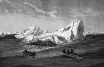
16 August, Sunday. North wind from 4 until 10 a.m.Footnote 80 As the fog rose at 4 a.m. sighted the mountains of Novaya ZemlyaFootnote 81 Noon latitude 76° 47′. In the afternoon the coast was more clearly in sight. We are further east than we had thought. In front of us lies the scenery of which we had enjoyed a surfeit during September and October 1872. The area of our provisions depot is not yet in sight; it will be about 40 miles from here. With a light WSW wind we are heading almost into the wind, under oars. The men are now almost exhausted. I therefore had a good 3 lbs of food issued. Persistent fog, so that there is no sign of the land. We're having to steer at random; one hopes that we don't land in the deep embayment east of the depot.
17 August, Monday. The fog is still the same. I am uncertain as to the direction of the depot, and am groping in the dark as to the course to steer. Until 8 am. I steered a course of SWbS, then WSW. Plenty of signs of life around us. Masses of little auks, guillemots, seals etc. Water temperature up to 3°R. Full of jellyfish, crustaceans, etc. Everything is indicative of the Gulf Stream. The air is mild and the weather magnificent. The only unpleasant aspect is the dampness resulting from the persistent fog. Our furs and sleeping bags are wet. From 2 a.m we headed south. At 4 it was clearing. This revealed that we are further south and significantly further west than our depot. The Admiralty Islands [Ostrova Admiral'teystva]Footnote 82 and the entire coast to the north are in sight. Under these circumstances have decided to abandon the depot and to head directly south. With a fresh northeast wind we headed in to land. I wanted to put ashore here to get water and to make tea; but couldn't find a suitable spot anywhere.Footnote 83
18 August, Monday. Beautiful weather; almost calm. Rowed until 4 p.m. Since we haven't had a proper night's sleep since the 13th, and we absolutely need some rest, and since moreover it is the Kaiser's birthday today, I had the boats hauled ashore for the night on the open coast. I thought I was on Admiralty Island [Ostrov Admiral'teystva] and spotted my mistake only too late.Footnote 84 As a result of our uninterrupted sojourn in the boat we were quite awkward and as if drunk when we clambered ashore. Previously I had thought the story of the seaman's unsteady gait was a myth, but now I have an example of it before my eyes. In places the vegetation was quite luxuriant where we camped for the night. Incredibly beautiful forgetmenots, so beautiful that I suspect that they are not forgetmenots.Footnote 85 Celebrated the Emperor's name's day with a stiff drink, and hoisted our flags. The grog had quite the opposite effect from what I had expected. In all of us it produced such heat and excitement that we got little sleep. The men slept in the open, since they could not tolerate being under the boat-tents. I stayed in the boat, but couldn't close my eyes all night. Got under way at 5.
19 August, Tuesday. Had to haul the loaded boats through the surf that had become quite heavy, to reach deeper water. My boat ran aground and we had to flounder belly-deep in the water to refloat it.Footnote 86 Fortunately it was not cold, and was calm. Tried smoking dried, used tea leaves mixed with moss and pea-sausage paper; it neither tastes nor burns well. Dug out a few crumbs of tobacco from my various pockets; they, by contrast, tasted delightful when mixed with hair. Swung around the real Admiralty Island [Ostrov Admiral'teystva] and at midnight found ourselves at Mashigin Inlet [Mashigina Guba]. The maps are pitiful. A strong opposing current near the coast. The temperatures are delightful – just like at Naples as far as we are concerned. Air temperature +6°; water +4°R.
20 August, Wednesday. Calm then a favourable northeasterly wind. Until 8 p.m. we were crossing Cross Bay [Krestovaya Guba]. Ahead of us lies the last point that hides Matochkin Shar, the goal for which we have been striving. We hope there is a ship there, otherwise we'll have to continue south to Goose Land [Gusinaya Zemlya] or Vaygach. We are now shooting birds; but to avoid delay we can shoot only birds that are right in the boats’ path. I shot 14 little auks. Our daily issue of provisions is now 2 lbs again. In my boat, at 4 a.m. one third of a can of boiled beef was warmed to the point that the fat became soft. To this were added 1 biscuits and 1 ration of chocolate. The same ration was issued at 6 p.m., minus the chocolate. At noon a thick porridge-soup and 2 lbs of pea-sausage, 3 lbs of pemmican, the remainder of the boiled beef and flour. At midnight we were off Shallow Inlet [Zaliv Melkiy].
21 August, Thursday. Soon after midnight a southeasterly wind with severe gusts started blowing. Because of No. 4 (the jolly boat) I had to head off shore and lost the lee of the land. The boats were working heavily and shipping a lot of water. Despite this we managed to work back inshore. Everything thoroughly soaked. Anchored well up the large bay before Dry Nose [Sukhoy Nos]. Cooked a meal on shore and dried out.Footnote 87 Set off again at 2 p.m. Found two glass globes such as fishermen use on their nets. One of them carried the Aesnees trademark. It is amazing the amount of ships’ wreckage that is lying around wherever one puts ashore. There is so much of it, that it can't possibly all derive from ships that have run ashore locally. It almost looks as if this is the major burial ground for all ships that are wrecked on the Russian and Norwegian coasts.
22 August, Friday. Rowed all night into a high, confused sea, to reach Matochkin Strait [Matochkin Shar]. At 1 a.m. began using all the oars in order to make any progress. Reached the entrance to Matochkin Strait at 9 a.m. Not a soul to be seen. Rowed some distance into the strait, and ultimately found that everything appeared to be deserted, so that I began thinking that we were somewhere else entirely.Footnote 88 But my noon latitude revealed the correctness of my navigation. In the afternoon sent Carlsen with the jolly boat as far eastFootnote 89 as possible to look out for ships. I had the boats hauled ashore on the south shore near the entrance and intended letting the men sleep for a full 8 hours before we go any further. The stresses of the last 8 days have been unusually great. The men whose watch started yesterday evening at 8, were rowing almost continuously until noon today. I am so sleepy that after we had hauled the boats out I fell asleep on the bare rocks. I carried out a precise distribution of provisions so that each boat has precisely the quantity of each item appropriate for the number of mouths. I don't intend continuing my search for ships here any longer. Between here and Northern Goose Cape [Severnyy Gusinyy Mys] I shall check at two more places to see whether there are any salmon fishermen there. If this is not the case I'll go directly to the White Sea. At 8 o'clock Carlsen came back without having seen any ships. On the other hand he had found a Norwegian whaleboat hauled up on land and carefully placedFootnote 90 but without any equipment. He had also seen quite fresh human tracks. Towards the middle of the strait he found a lot of ice and had to turn back because of a violent headwind. A strong east wind produced heavy surf so that we could proceed only at 11 a.m. on
23 August, Saturday. We've enjoyed a good, sound sleep, and could now tolerate a few more sleepless nights. We deposited a document and various cans with names and the date. We ran along the coast. In the evening, off the unnamed bay south of Mushroom Bay [Guba Gribovaya] we encountered a rapidly strengthening east wind with a confused, irregular sea. Waves were washing continually over the boats; in no time we were all soaked to the skin. We had to bail constantly. The boats were separated in the darkness. A miserably cold, wretched night. Around 3 a.m we got into calmer waters on the other side of Mushroom Bay and headed towards Cape Britvin [Mys Britvin] at a good speed, close inshore.
24 August, Sunday. At 6 a.m. ran the boat up the beach to wait for the other boats. Lit a fire, cooked a meal, dried our things and managed to reach a comfortable state again. Pushed on again at 8. Left instructions for the following boats by a large fire; they were to follow me round Mys Britvin to the Down River [Pukhovaya]; and in the event that they did not meet me there, they were to go along the coast to the Reznikova [Reznikov's River] and from there to Northern Goose Cape. I shall wait there until 28 August, on which date I shall start directly for the White Sea via Kolguev Island. Around noon a boat was spotted off Cape Britvin, one of those we were expecting. At 3 in the afternoon the others also arrived. The two smaller boats had not been able to handle the seas in Mushroom Bay, and had run for shore.Footnote 91 Our situation during last night was extremely unpleasant. Nights like that are tougher than the toughest trials of a sledge trip. Once the boats had arrived we pushed on immediately.Footnote 92 Ran around Cape Britvin into Down Inlet [Zaliv Pukhovyy]. At 6.30 in the evening spotted a boat with two men in the lee of an island; they were Russian salmon fishermen whose ships lay further over.Footnote 93 They led us aboard, where we were welcomed with extraordinary friendliness.Footnote 94 These are two handsome little schooners, Nikolai, Captain Fedor Voronin and Vasily, Captain Vasily. We were accommodated on board the former.Footnote 95 The Captain wanted to stow me forcibly into his own bunk, but the heat in it was intolerable for me. None of us could stand the heat from the stove. I lay down on a reindeer skin on the deck; the others slept in the hold.
25 August, Tuesday. None of us has slept much; for all of us our lucky rescue has more or less gone to our heads. Chartered the schooner for 1200 rubles and three of our boats to take us to VardøFootnote 96 The Captain proposed that we stayed aboard until he had finished fishingFootnote 97 and then travel with him along the coast to the White Sea. But how long he stays here on Novaya Zemlya is quite undetermined, and might possibly still last for a whole month. In that case food, the extension of salaries and the long overland journey from Arkhangel'sk to Vienna would greatly exceed the cost of the charter. Our own provisions might last for only about another two weeks. Fedor is a superb example of a good-natured, honest, orthodox Russian. Almost continually fasting. His second-in-command, and interpreter is Maximin. For us, accustomed to pure air, our stay in the hold, absolutely polluted by salmon, furs, blubber, beluga hides etc. is really terrible. Circulars from the Russian government; slow emergence of the political news.Footnote 98
26 August, Tuesday. Under way under sail.Footnote 99 Primitive navigation. No log on board. Everything by dead reckoning. A fresh east wind for 48 hours, then a west wind.Footnote 100
29 August, Friday. Murmansk coast. Nokuev Island [Ostrov Nokuev] in sight. Begged for tobacco from a Russian schooner; they had none. Received 18 cakes of chewing tobacco from the Bremen vessel, Helios, Captain Hemke. Repulsed by the Swedish schooner Njord in the most unfriendly fashion. Beat along the coast. We're so glutted with salmon, reindeer meat and half rotten eggs, that our old soup would be a real treat. The Russians extremely accommodating.
3 September, Wednesday.Footnote 101 Reached Vardø at 4 p.mFootnote 102 Found printed letter.Footnote 103 Extremely friendly reception.
Assessment
The retreat of the crew of Admiral Tegetthoff south from Zemlya Frantsa Iosifa in the summer of 1874, ranks as one of the mot impressive journeys in the history of polar exploration in terms of the mental and physical endurance of the men involved. Their southward progress was incredibly slow. The slowness of their advance was undoubtedly in part because they were constantly relaying, moving ahead first with the boats on sledges, then back-tracking to where they had left the other sledges, and then hauling them forward. Thus after a week (on 28 May) they were still only 4.5 miles from the ship. In early June progress was retarded even further, first by a decision to retreat back to Ostrov Lamon [Lamont Island] to wait for ice conditions to improve, and then by the decision to send a party back to the ship to pick up a fourth boat. But even after they had continued the southward advance, by 26 June (after more than a month) they were still only 10 miles from the ship, and on 9 July, after 50 days the summits of Ostrov Vil'cheka (their starting point) were still visible.
Their extremely slow rate of advance was undoubtedly also partly due to the northward drift of the ice whenever there were winds from a southerly quarter, that is some or all of the ground gained towards the south was offset by the ice drifting in the opposite direction. On at least two occasions, they were actually travelling back north. Thus between 5 and 7 July, the ice drift carried them back north by 2′ 30″ of latitude (that is 2.5 nautical miles), while between 27 and 29 July they were again carried back north by 2 nautical miles. This was the same discouraging phenomenon that Captain William Edward Parry had encountered during his attempt at reaching the pole across the ice from Svalbard in 1827, and which he concealed from his men fearing that it might dangerously discourage them (Parry 1828: 99). Weyprecht probably also concealed this disheartening news from his men. Certainly there is no mention otherwise in his journal. What is clear is that only a charismatic and popular leader could have maintained morale in the face of such discouragingly slow progress.
Unlike the members of practically every other arctic expedition, the expedition personnel were largely from the warm, Mediterranean climate of what is now coastal Croatia, the type of men with whom Weyprecht was familiar from his service in the Austro-Hungarian Navy. In a letter to his close friend, Heinrich von Littrow, written on the voyage back south on board the steamer Finnmarken, Weyprecht discussed how his decision to employ such men, and how well they had performed had been vindicated. He also expressed his pride at how harmonious relations had been during the retreat, and how the men had never displayed any unrest at their obviously very slow progress (Weyprecht Reference Weyprecht, Berger, Besser and Krause1874b).
Even after the appearance of leads and polynyas allowed them to travel at least part of the time by water, that is after 17 June, the very broken nature of the ice determined that progress was still very slow. It involved an endless sequence of hauling boats and sledges across a floe, launching the boats and rowing as far as possible along a lead or across a polynya, towing the sledges, then hauling out onto the ice, restowing all the gear and provisions on the sledges, and man-hauling boats and sledges across the next floe to the next lead or polynya. Both boats and sledges suffered considerable wear and tear during the operations of launching and of hauling out. On one particular day (19 July) this sequence of events was repeated 11 times!
A surprising feature of the retreat (and of the entire expedition) was the remarkable number of bears that were killed and eaten. The total had already reached 62 before they left the ship and a further 5 were killed and eaten during the southward retreat across the ice. Some of the meat was undoubtedly eaten by the dogs. But the men were also eating bear meat, and in the case of at least one animal (on 19 July) the meat was eaten raw. In doing so the Austrians were running the risk of developing trichinosis, a disease of which many bears are carriers, and which has caused serious illness and death on a number of arctic expeditions. For example it resulted in all but one member of the German weather station on Zemlya Aleksandry (Alexandra Land) in 1943–1944 (Operation ‘Schatzgräber’) becoming seriously ill, and having to be prematurely evacuated by air (Dege Reference Dege and Barr2004).
The Austrians also killed a large number of seals, 44 from the ship and a further 18 during the retreat, both harp seals (Phoca groenlandica) and bearded seals (Erignathus barbatus). Weyprecht and some of the men became very partial to eating raw seal blubber. It was undoubtedly to this that they owed their relative freedom from scurvy.
Given the tedium and discomforts of their incredibly slow progress, it would have been surprising if interpersonal frictions had not developed. There is no mention of any such conflicts in Payer's published narrative (1876) but in the privacy of his diary Weyprecht had no compunction in complaining of Payer's shortcomings. Typical of these complaints was his criticism that Payer's trips back to the ship during the first few weeks of the retreat were driven in part by his desire to sleep comfortably on board, and also to provide a supply of ‘treats’ for his own enjoyment (24/30 May). Later Weyprecht accused Payer of taking no part in the all-important activity of hunting (2 August) and criticised his inability to navigate (5 August). One wonders if Payer was recording similar criticisms of Weyprecht in his diary, which has never been published in full.
What appear to have been milder differences of opinion also occurred between Weyprecht, the naval officer, and Carlsen, the experienced veteran arctic skipper. That they were not more confrontational appears to have been due to Carlsen's diplomacy.
As regards the long-term results of the expedition, its successful retreat from Zemlya Frantsa Iosifa meant that its cartographic and scientific results were largely saved for posterity. Apart from Payer's map of much of the eastern half of the archipelago, substantial amounts of meteorological, geodetic and magnetic data were brought south (Österreichische-ungarische Arktische Expedition 1878). The geological and most of the natural history collections had to be left behind, but a limited collection of invertebrates was saved. In addition Weyprecht later published the results of his observations on the nature and behaviour of arctic sea ice (Weyprecht Reference Weyprecht1879). This latter is a remarkable early compendium of information, covering practically every aspect of the physical nature of arctic sea ice, including an impressive discussion of the patterns of ice drift based on the movement of driftwood, which although understandably not so detailed, predates the results of Fridtjof Nansen's experimental ice drift on board Fram in 1893–1896 (Nansen Reference Nansen and Nansen1902) by over 20 years.
Acknowledgements
I wish to thank Dr. Bruno Besser for his gift of a copy of the book Carl Weyprecht (1838–1881). Seeheld, Polarforscher, Geophysiker, and for putting me in touch with the Verlag der Österreichischen Akademie der Wissenschaften, and also that institution for permission to publish this translation of Weyprecht's diary. I am indebted to Heinz Slupetzky for permission to reproduce Figs. 4 and 5 which first appeared in his article ‘A history of the Austrian discovery of Franz Josef Land. The Austro-Hungarian Teggetthoff expedition 1872–1874’ (Slupetzky 1995). My thanks also go to Dr. Peter Schledermann for his oral translation of Elling Carlsen's diary.