


Introduction
It is now more than five years since a high-magnitude earthquake struck Japan's eastern seaboard on 11 March 2011, rapidly followed by a massive tidal wave and, much more ominously, an unprecedented triple reactor meltdown at the Fukushima Daiichi nuclear power station. Although radioactive material continues to seep alarmingly into the sea (apparently all the way to California) and vast swaths of landscape remain contaminated or out of bounds, global attention has since faded and shifted elsewhere—consider, with regard to cultural heritage alone, the wilful destruction of archaeological sites in Mali, Iraq and Syria, or the 25 April 2015 earthquake in Nepal. It would, however, be a grave mistake for us to forget Fukushima, let alone take at face value the ‘all-under-control’, ‘soon-back-to-normal’ messages broadcast by interested parties. For the nearly 20 000 victims and ten times as many evacuees, the earthquake and its aftermath are emphatically not yesterday's news. The same goes for the many individuals and communities still struggling today with the Herculean-cum-Sisyphean tasks of containment, decontamination and reconstruction over an area of some 2000 square kilometres in the Tōhoku prefectures of Fukushima, Miyagi and Iwate. The combined effects of the earthquake, tsunami and nuclear accident on the country's economic, political and existential landscapes have already been severe, and are bound to generate many conceptual and practical aftershocks for generations to come. While the catastrophe has some strikingly événementiel aspects to it—its onset at 14:46 on that Friday, the height of the tidal surge at 2km inland, the yearly millisievert dose of caesium-137 just outside the 20km exclusion zone—it also has its own deeply grounded, structural, longue durée implications. As we shall see, these multi-faceted repercussions also have direct and indirect bearings on the fields of archaeology and cultural heritage management within Japan and, indeed, worldwide. By straining archaeological capacities and imagination to the utmost, Fukushima and its aftermath may well foreshadow a future that awaits us all.
In briefly raising some of these issues here, we authors need to acknowledge outright our positions as outsiders, or at best, participant-observers. Our aim is not to provide a comprehensively documented overview of what is clearly an extremely complex and still fluctuating situation, and nor is it to update accounts already provided by far better placed eyewitnesses and actors—most notably in Antiquity by Okamura et al. (Reference Okamura, Fujisawa, Kondo, Fujimoto, Uozu, Ogawa, Kaner and Mizoguchi2013) and Kaner et al. (Reference Kaner, Habu and Matsui2011), as well as Kaner (Reference Kaner2011, Reference Kikuchi2015); Abe & UFSCBFF (Reference Abe2013); Okamura (Reference Okamura, Willems and van Schaik2015); Negita (Reference Negita2012); Kikuchi (Reference Kikuchi2015); and Kikuchi and Nespoulous (Reference Kikuchi and Nespoulous2015). Rather, our comments reflect some archaeological perspectives prevalent in European countries with broadly comparable social and economic conditions to Japan, which differ, however, in their archaeological experiences with regard to disasters and their management. It can be surmised that the forthcoming meeting of the World Archaeological Congress (WAC) to be held in Kyoto, Japan, in late August 2016, will provide an excellent opportunity for debating these issues and highlighting their wider implications.
We will begin with the notion of ‘disaster-led’ preventive archaeology, move on to issues of contamination and decontamination, and then reflect on some memorial, therapeutic and critical contributions that archaeology could make, notably within a planned ‘museum of disasters’. Our concluding, and admittedly provocative, proposal is that the nuclear plant and its vicinities should be declared a protected heritage site of national and, indeed, international importance. By ensuring that its remains are physically preserved rather than cleared away, it will become possible at the earliest opportunity—hopefully in a matter of decades rather than centuries—to approach Fukushima Daiichi as a unique historical monument, materialising the feats and failures of turn-of-the-millennium modernity.
‘Disaster-led’ archaeology
Even if we leave aside for now the nuclear accident and its unfathomable aftermath, there was clearly enough power in the 9 megawatt earthquake and the 30m-high tsunami wave that followed to wreak unprecedented havoc throughout the Tōhoku region. The ensuing damage to the physical and historical environments included a wide range of heritage resources—buildings, fortifications, shrines and archaeological sites, as well as museums, repositories and storage areas—many of which were destroyed, contaminated or rendered inaccessible. Previous recordings of heritage elements over the past 50 years provide considerable information on the sites affected by the current disaster. In the Fukushima prefecture alone, some 295 such ‘cultural properties’ (labelled at national, departmental or local levels) have been damaged or destroyed (Okamura et al. Reference Okamura, Fujisawa, Kondo, Fujimoto, Uozu, Ogawa, Kaner and Mizoguchi2013: 260; Kikuchi Reference Kikuchi2015: 30). The total repair bill—for those elements that can actually be quantified and compensated—reaches over 5.3 billion yen (40 million Euros).
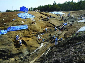
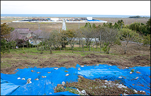
Moreover, as we well know, this direct, observable destruction represents only the tip of the iceberg. Far more ominous is the ‘collateral damage’ now facing those ‘buried cultural properties’ (i.e. archaeological sites) that have hitherto lain underground, unrecorded, unprotected and also undisturbed—precisely the remains that it is the aim of preventive archaeology to identify, study, make known and preserve (cf. Demoule Reference Demoule2012; Schlanger Reference Schlanger and Silberman2012). Indeed, experience teaches us—notably following the Haiti earthquake of 12 January 2010 (cf. Kurin Reference Kurin2011)—that the gravest dangers facing buried archaeological remains may well occur after the catastrophe, during the clearance and reconstruction phases. In Japan, the large-scale infrastructure and regeneration projects instigated across the Eastern seaboard have included the renewal of rail and road networks, the consolidation of harbours and the construction of massive tidal embankments (which actually put both the coastal region's cultural landscape and the livelihood of its inhabitants under threat; see Okamura Reference Okamura, Willems and van Schaik2015: 248). In addition, a range of projects have been launched for resettling evacuees in new public housing just above the tsunami line—that is, on higher ground that has proved particularly rich in archaeological occurrences. Despite numerous difficulties, a commendable range of preventive archaeological interventions has already preceded these developments. The municipality of Minamisōma, for example, has integrated archaeology into its reconstruction efforts: by July 2012, no fewer than 663 archaeological clusters had been identified across its territory. In the locality of Higashimachi, just above the upper reach of the 2011 tsunami, a Middle Jōmon site (mid third to mid second millennium BC) has been excavated prior to the construction of several residences (Figure 1). Although they are built on archaeology-rich land, such small-scale housing is clearly more appropriate than high-rise towers for resettling displaced communities. Somewhat different aims have motivated archaeological operations at the Tenkazawa A excavation site, a 3ha wooded hilltop under assessment for remains of Heian-period (ninth–eleventh centuries AD) iron-smelting activities. Once the investigation is over, the whole hilltop will effectively be truncated to provide hundreds of tonnes of arable soil for a nearby valley whose own soils were washed away and polluted by the tsunami wave (Figure 2).
Community involvement in preventive archaeology at the Middle Jōmon site of Higashimachi (photograph: Yoshio Kikuchi, May 2014).

Preventive investigations at Tenkazawa A; at the completion of the excavations, this hill top will provide arable soil for the tsunami-hit area (photograph: Testsuya Ogura, October 2014).

Driven by a sense of force majeure, and testing the discipline's organisational capacities to its limits while bringing its core expectations to the fore, this is ‘disaster-led’ archaeology—a term that obviously echoes but also challenges the better-known notion of ‘developer-led’ archaeology. This largely corresponds to the Japanese notion of fukkō chōsa—‘restoration excavations’, developed after the previous major earthquake at Kobe in 1995—whereby archaeological activities are integrated into the reconstruction efforts and do not hinder them (Kikuchi Reference Kikuchi2015: 38, Kikuchi & Nespoulous Reference Kikuchi and Nespoulous2015: 62). Thus, the pressing economic and humanitarian needs of uprooted communities can lead to reconsideration of some established norms of archaeological research and heritage protection. For example, the in situ preservation of archaeological vestiges at the expense of planned developments is probably not a viable option—not that this in situ alternative, often favoured as a cost-cutting solution, was ever such a panacea for sound heritage management (as Willems (Reference Willems2012) had cogently argued). Similarly, urgent works needed to re-establish essential utilities and communications infrastructure could well see prior impact assessments or authorisations temporarily waived. Such practical and procedural adjustments, be it in the field or in post-excavation contexts, can certainly be justified—provided, that is, that they are implemented and controlled within a responsible and accountable ‘disaster-led’ framework. In 2011, both local and national authorities recognised outright the need for such a coordinated framework, including crucial aspects such as financial support, scientific and management expertise and, above all, qualified personnel. Indeed, the mobilisation that followed saw as many as 60 professional archaeologists from over 20 prefectures seconded for many months to the region, to direct or assist with preventive archaeological operations—including, as mentioned above, at Minamisōma (see Kikuchi Reference Kikuchi2015; Okamura Reference Okamura, Willems and van Schaik2015).
The great resolve manifested throughout this collective effort, however, cannot hide a sense of foreboding, a feeling that such a public-spirited ‘disaster-led’ mobilisation may well be the last of its kind. Over the past half century, archaeological heritage management in Japan has followed a distinctive and highly satisfactory path (see Mizoguchi Reference Mizoguchi2006; Demoule & Souyri Reference Demoule and Souyri2008; Inada Reference Inada2015). Soon after the Second World War, the ‘polluter/payer’ principle for rescue or preventive excavations came to be enshrined in practice, if not in law, and was applied mainly by regional and municipal authorities well tuned to local communities and their heritage needs. Following the major industrial boom of the 1970s, Japanese archaeology grew exponentially—predominantly outside academia, it must be said—peaking in the late 1990s with some 2000 excavations undertaken annually by over 7000 professionals, employed in municipalities, prefectures and, in smaller numbers, at state level. This tight archaeological mesh was activated in the aftermath of the 1995 Kobe earthquake, providing funding for preventive excavations also on private lands (in addition to public works), and easing an acute local shortage of competent archaeologists by welcoming professionals from across the country (see Okamura et al. Reference Okamura, Fujisawa, Kondo, Fujimoto, Uozu, Ogawa, Kaner and Mizoguchi2013: 263–64). With the 2011 Tōhoku events, however, the challenge was not simply to upgrade this response to the enormity of the current disaster—it was also to tackle the economic-cum-ideological tidal wave that has since penetrated to the very foundations of Japanese archaeology.
Major reforms introduced in Japan since the early 2000s, notably in the context of an economic downturn, have encouraged the privatisation and deregulation of a wide range of public services, including communications, utilities and education. Private companies began to invest in the field of archaeology, especially in the form of large construction and engineering corporations that created spin-off or subsidiary units for undertaking archaeological operations on their development schemes. Having successfully lobbied for access to the ‘market’ of preventive archaeology, these private units now seek a profitable share in the richly endowed 2011 reconstruction funds. Lacking, however, the necessary local grounding, and unconcerned about community involvement, heritage enhancement or knowledge production, these units effectively prioritise profitability over quality standards and research requirements. What is more, as commentators have noted (see Okamura Reference Okamura, Okamura and Matsuda2011, Reference Okamura and Smith2014; Zorzin Reference Zorzin2013; Inada Reference Inada2014), enforced decentralisation, diverging agendas and fragmented operations make it increasingly difficult for state bodies such as the Agency for Cultural Affairs (Bunka-chō) to fulfil their oversight and regulatory role—a task clearly rendered all the more indispensable given the pressures, noted above, to adjust archaeological ‘disaster-led’ standards to the imperatives of reconstruction. At a time when trillions of public yen are being spent to bail out private energy corporations, the state's rampant disengagement from its hitherto efficient public archaeology framework appears all the more incoherent. A real risk emerges that policies favouring private or sectorial commercial considerations and the reduction of statutory responsibilities—a logic unfortunately known to underpin ‘developer-led’ archaeology in quite a few other countries and continents, it must be said—will unravel this painstakingly woven fabric of professional solidarity and social relevance that surely must lie at the heart of any ‘disaster-led’ archaeology.
Decontamination galore
The risk that Japanese archaeology might become less resilient to future catastrophes is all the more worrying given the extensive ‘disaster’ experience it has already accumulated. Ranging from the management of natural calamities and their aftermath to the aggravating effects of human and technological accidents, this experience constitutes an invaluable asset, to be recognised and enhanced at a global scale. Moreover, so far as the nuclear dimension is concerned, this expertise is not only unique but also—unfortunately—bound to increase over time. When the tsunami wave of 11 March 2011 easily overtopped the protection walls of the Fukushima Daiichi nuclear power station to destroy the feeding units and provoke a general cooling failure, the resulting reactor meltdown released substantial projections of radioactive elements such as iodine-131, caesium-134 and caesium-137. These elements contaminated the immediate surroundings of the plant, but also reached far more distant locations. By the summer of 2011, a more complex ‘3-zone system’ was established, including also, beyond the 20km perimeter already evacuated, the areas sprayed by easterly winds along the Vale of Iitate, a mountainous corridor linking the Pacific coast to the city of Fukushima some 60km inland (Figures 3 & 4).
Map of the spread and intensity of radioactive pollution from the Fukushima Daiichi nuclear plant, as of 18 September 2011 (Japanese government source).

Map of exclusion and restricted access zones around Fukushima Daiichi nuclear plant, as of 5 September 2015 (source: Japanese Ministry of Economy, Trade and Industry, http://www.meti.go.jp/english/earthquake/nuclear/roadmap/index.html).

A distinction must be made here, in the realms of archaeology and heritage management, between the challenges due to increased radioactivity itself, and those deriving from attempts to decontaminate it. Inevitably, numerous elements of cultural heritage around the nuclear plant have been irradiated, be they specific sites or materials held in museums or repositories. While the actual physical or chemical damage caused to ancient pottery, ethnographic costumes or archival holdings remains unclear, their prospects are dire: until they are each individually cleaned, these hitherto valuable heritage items remain life-long hazards. The Fukushima Compromised Cultural Properties Rescue Service Headquarters, established in 2012, has therefore begun to ‘exfiltrate’ lightly contaminated cultural items from their previous holdings in Futaba, Ōkuma, Tomioka and other settlements in the forbidden zone (see details in Kikuchi Reference Kikuchi2015; Kikuchi & Nespoulous Reference Kikuchi and Nespoulous2015). Gathered north of Minamisōma, tested for radiation and inventoried, these items are then transferred to a dedicated storage facility located in Shirakawa. While these movable items (4000 boxes, as of October 2013) will ultimately benefit from conservation measures, far more cultural elements—including many not contaminated—will remain inaccessible in the exclusion zone, bereft of monitoring, maintenance or repair. As basic infrastructures are shut down or left unattended, museum display cases will suffer from temperature fluctuations, storage containers might crumble or rust, and organic items of wood or cloth, together with library and archival contents, will gradually decay or fall to infestations. The same goes for ‘standing cultural properties’ and archaeological sites in the exclusion zone, such as the painted Haneyama corridor-tomb in Minamisōma or the Urajiri shellmound archaeological site (Figure 5), now more vulnerable than ever to the vagaries of the elements—which include, lest we forget, the near certainty of further earthquakes. To cap it all, even the small mercy that might have been expected here—that this radioactivity would at least protect archaeological sites from development-related damage—may prove illusory, given the unprecedented decontamination efforts now underway.
Urajiri Jōmon shellmound, a declared Site of National Importance, where excavations were interrupted on 11 March 2011, and are still uncertain to resume; from the mound and its makeshift protection, a seaward view to a temporary storage location for contaminated waste (photograph: Laurent Nespoulous, October 2014).

In Japan (unlike, for example, Chernobyl) a range of demographic, economic and, particularly, political considerations have led the Government to launch the most extensive nuclear clean-up operation ever attempted. The tolerated radiation dosage, conveniently raised after the accident to 20 millisieverts per year (mS/y), has now been reinstated by law to 1mS/y. Consequently, a vast area of over 2400km2 (comparable in size to Luxembourg or nearly twice Greater London) has been designated an ‘intensive decontamination survey area’, of which some 600km2 are a ‘special decontamination area’. Apart from the highly constrained conditions immediately surrounding the still-leaking nuclear plant, decontamination of the mainly mountainous wooded and agricultural area proceeds in ways that appear extremely time-consuming, surprisingly low-tech and, in several senses of the word, superficial. As the airborne radioactive elements—essentially caesium-137 with its 30-year half-life—tend to cling to surfaces, the task is to scrub them out: public buildings, schools and residences are scoured, roads and tarmac are pressure-hosed, agricultural topsoils are scraped out, ditches scooped, grasses cut, branches and foliage pruned, trees are trimmed and even, especially around houses, have their bark shaved off. Thousands of largely unskilled, manual workers paid on a daily basis, clad in white protective gear, have been mobilised for these painstaking tasks, and it is surely a jarring irony to see among them, alongside local municipal workers, many employees of huge construction companies such as the Kajima Corporation, which built the Fukushima Daiichi plant nearly half a century ago. While these clean-up operations are manifestly profitable—an estimated 2.48 trillion yen (20 billion Euros) are to be disbursed by the central authorities—it remains to be seen whether these measures are effective and not just palliative, displaying technological zeal to clean up, at the very best, 70 per cent of the attested contamination and all the while shifting radiation around.
What is certain, however—inescapably so—is that these decontamination operations, bound to be repeated over several years, generate a huge amount of waste, partly rubble and debris and partly sediments and organic materials, that have to be disposed of. As with all other figures given here, estimates vary, but as many as 50 million tonnes of (however lightly) contaminated material, stuffed into cubic-metre black bags and loosely covered by plastic or tarpaulin sheets, are being piled up as so many eyesores throughout the Tōhoku region, distributed over 700 temporary storage zones, alongside crossroads and under hills, or gathered into municipal dumps (Figures 5 & 6; see also Podniesiński Reference Podniesiński2015).
A small-scale temporary storage site for contaminated soil, near Minamisōma (photograph: Jean-Paul Demoule, October 2013).

This unfathomable plague of decontamination not only immensely complicates reconstruction efforts in the present, but it also blights the future in ways that will affect the perception and preservation of the past. For one thing, as experts have already warned, this patchwork of topsoil scraping and vegetation clearing has important implications for the natural environment: the increased soil degradation, runoff and landslide risks will lead to a range of ecological damage, including the further erosion or burial of many archaeological sites. Furthermore, the historic environment is bound to be crucially affected by the management, storage and disposal of the contaminated waste. Now seeping pollution and fermenting organic contents all over the landscape, these millions of black bags are ultimately due to be assembled into dedicated storage and treatment facilities near the coastal towns of Futaba and Ōkuma. Whether or not this long-term ‘interim’ storage will indeed be dismantled after 30 years as promised, at stake here are two vast industrial complexes comprising access roads, drainage ditches and stockpiling silos spread over some 16km2—areas that, deliberately located deep within the high-radiation forbidden zone (‘given up for lost’?), will nevertheless have to undergo thorough preventive archaeological surveys and excavations to identify, document and study as best as can be a past that the future will otherwise never know.
Towards the contemporary future
In the grand scheme of things, considering the human suffering and financial cost incurred—a total repair bill of 11 trillion yen (84 billion Euros) is now bandied about—archaeology may not count for much. It is nevertheless well placed, we believe, for making distinctive memorial, therapeutic and critical contributions to society at large, in Japan and beyond. Appreciating just how daunting the combined earthquake, tsunami and nuclear catastrophe of 2011 have been makes the ensuing experience of ‘disaster-led’ archaeology all the more invaluable, a unique accumulation of skills and acumen that deserves to be highlighted.
One way to build on these hard-learned lessons is through a dedicated ‘museum of disasters’, as proposed by Professor Y. Kikuchi of Fukushima University and colleagues (Abe & UFSCBFF Reference Abe2013; Kikuchi & Nespoulous Reference Kikuchi and Nespoulous2015). As it is imagined, such a museum could serve as a platform for studies and information-sharing relating to catastrophes and their aftermaths, matters about which there is growing academic and heritage management interest worldwide. Classifying disasters according to their agencies or impacts—natural, human or in combination; sudden or slow-onset; localised or diffuse—and understanding how they unfold, how societies foresee, cope, recover and move on, become all the more relevant to the present. The same goes for a repository of heritage disaster-management procedures, including anticipatory measures, ‘dos’ and ‘don'ts’, the involvement of stakeholders and international bodies, or even guidance on ‘the material culture of decontamination’. The increasing frequency and severity of catastrophes around the world confirms the utility of such an archive. Leaving aside any potential nuclear accident, recall the 2004 Indian Ocean tsunami (Rico Reference Rico2014), the 2005 Hurricane Katrina (Dawdy Reference Dawdy2006) and, indeed, the recurrent flooding episodes in Western Europe and elsewhere, due to a combination of extreme weather (aided by global warming), reckless land use and administrative inertia.
Research and logistics aside, memorial functions obviously loom large in such a museum, at both local and universal levels. Records of previous earthquakes and tsunamis, especially in the region itself, become valuable resources. This is the case with a major catastrophe dated by ancient chronicles to the twenty-sixth day of the fifth moon in the second year of the Jōgan era (13 July 869 AD). While the ensuing destruction can still be identified through ongoing archaeological excavation north of Minamisōma, the descriptions given, including rivers flowing backwards 3km inland from Matsushima bay, strongly recall the poignant scenes of 11 March 2011. Much like the venerable Nihon sandai jitsuroku official chronicles, so too the amateur videos and mobile-phone recordings from that tragic afternoon constitute precious testimonies. The creators of these records will undoubtedly appreciate that their images—still etched in our minds, but for how long?—are safely kept, properly referenced and made widely available in a dedicated media centre. The transmission of knowledge regarding past earthquakes and tsunamis is clearly essential. Just as they confirm the much vaunted resilience of local communities, such archaeologically documented occurrences also undermine the Japanese government and TEPCO's disingenuous claims of a ‘lack of precedents’ so as to wriggle free of any responsibility.
Likewise, the obvious involvement of local populations in such a museum should not obscure some broader stakes: there is increasing evidence that the genuine desire of many evacuees to return to their homes in the exclusion zone is also being cynically encouraged by the authorities, as they seek to broadcast their ‘back to normal’, ‘nuclear energy is safe’ messages, especially ahead of the 2020 Tokyo Olympic Games. In any case, remnants of local cultural heritage to be re-appropriated here encompass intangible living folklore and ‘matsuri’ ceremonies so nearly lost; landscapes to be mapped, drawn and memorised; and, of course, a range of artefacts—including the cultural resources ‘exfiltrated’ from the radiated zone, now decontaminated and restored—to be meaningfully displayed and enhanced with reconfigured narratives of identity, permanence and change. By necessity or design, the opportunity arises here to approach heritage in ways that are no longer solely object-centred but also process-oriented and experience-driven. No longer confined to forms and materials alone, heritage as a social construct entails engaged participation in its production, reproduction and preservation through time. In this light, one can appreciate the Reconstruction Agency's proposal that in each affected municipality, with local residents’ consent, a distinctive structure or building would be preserved in its ruined state, to commemorate the 2011 Tōhoku events (see Okamura Reference Okamura, Willems and van Schaik2015: 254–56; also Rico Reference Rico2014, for comparable considerations in Indonesia).
In addition to its important commemorative and therapeutic contributions, archaeology at Fukushima can also claim a broader, more critical role. The two dimensions that archaeology excels at manipulating and conceptualising—namely, materiality and temporality—can serve to communicate some unsettling, or at least consciousness-raising, insights across the wider social and political sphere. One such contribution consists in the banalisation, or rather normalisation, of destruction. Archaeologists routinely engage in recording layers of devastation, documenting patterns of decay and fragmentation, and keeping track of site formation and transformation processes. Dispassionately deploying their ‘methodological materialism’ and applying their ethnoarchaeological ingenuity to the ‘taphonomy of disasters’ (Dawdy Reference Dawdy2006), archaeologists can show that catastrophes are rarely, if ever, terminal, and that the decompositions they entail, whether above ground or below, widespread or in situ, are often recurrent and multiscalar. In this sense, the material record as a whole is a dialectical combination of absence and loss with construction and renewal. Just as archaeology can align the March 2011 catastrophe with comparable prior occurrences, it can also highlight the specificities of this particular destruction event, initiated by natural forces but then amplified so unexpectedly—or, rather, in ways that were insufficiently anticipated—to unprecedented proportions by the nuclear accident, reaching deep into the socio-technical fabric of late industrial modernity.
Materialist by method, archaeology can also confirm that time matters, as it were, both metaphorically and literally. It can serve as an antidote or a corrective to the unprecedented acceleration of the here and now, when continuous ‘live’ images saturate our short-term, dematerialised attention span. This shallow posture does not bode well for our capacity to transmit and to record—let alone to learn from—events and processes at historical scales. As we know, however, the full effects of decisions taken today—what radiation levels can be tolerated, how to upgrade energy strategies, indeed how to deal with the radioactive waste that increasingly piles up in the nooks and crannies of the planet—will rarely be measured in months or in years, let alone in electoral timeframes, as much as in generations, centuries and millennia. Driving this point home, shifting scale, decelerating, distantiating, archaeology can rekindle a sense of genuine responsibility among decision-makers and citizens alike. How we know what we now know of the remote past, how we balance inference and ignorance, reconstruct materiality and its absence, can all be relevant also for the distant future. Archaeology can help us to conjecture how, many years from now, we humans might be able to organise our lives, shape our environments, build our memories, indeed appeal to what will then still be present and available of the past in order to construct and give value to a heritage of our own (see Holtorf & Högberg Reference Holtorf, Högberg, Bergerbrant and Sabatini2013, Reference Holtorf and Högberg2014). This leads us to suggest here an archaeology by anticipation, as it were, an ‘archaeology of the contemporary future’ that obviously echoes and builds on that of the ‘contemporary past’ (Buchli & Lucas Reference Buchli and Lucas2001; Harrison & Schofield Reference Harrison and Schofield2010). Just as today's past along the Tōhoku coastline includes Neolithic shell-middens, medieval smelting furnaces and nineteenth-century fishing villages, so the historic environment of the future—as it began on 11 March 2011—will encompass also the ruins of the Fukushima Daiichi nuclear power station. This nuclear plant, an artefact of daunting, if somewhat dated, complexity, is rich in material equipment and infrastructure of various sorts, including concrete buildings and underground installations, pipes and rods of many calibres and compositions, pressurised tanks and containment vessels, channels, pools and evacuation ditches. Farther inland, beyond the deserted streets and crumbling dwellings of the Ōkuma and Futaba ghost towns, beyond their carefully cultivated landscape long since gone feral (see images in Podniesiński Reference Podniesiński2015), will be found specifically designed interim storage facilities for contaminated waste, with drifting plastic filaments and incinerated ashes spewing over trenches once dug as part of a preventive archaeological operation, at a time when the past underneath was still within reach.
During its decades of routine operation, Fukushima Daiichi had been a kind of ‘non-lieu’ of modernity (see González-Ruibal Reference González-Ruibal2008; Harrison & Schofield Reference Harrison and Schofield2010, after Marc Augé) in which rational technology radiated energy so smoothly as to be invisible. Now, after 11 March 2011, it could well be recognised as one of its foremost ‘lieux de mémoire’ (after Pierre Nora), a site where the structuring forces of industrial production gone awry are overtaken by the vagaries of avoidance, containment and makeshift repair. Since the coming years and decades will very probably see the appearance of quite a few more such dystopic palimpsests—‘places of abjection’ as González-Ruibal (Reference González-Ruibal2008) calls them—an archaeology of the contemporary future should ensure that obsolescence does not entail oblivion, that the urge to forget and to wipe clean, to redress, to start anew, does not come at the expense of memory and of history. Far from being razed away both above and below ground (in all likelihood by the same consortium who built it), the nuclear power station inaugurated in the late 1960s, along with the emergency apparatus hastily concocted after 2011, containment walls, water tanks and all, should stand as a long-term material witness, as a documentary and memorial monument—as heritage, if you will—to be engaged with by the societies of the future.
Hence we offer this admittedly provocative proposal to work towards the inscription of the Fukushima Daiichi nuclear plant and its vicinity as a protected national heritage treasure. And, why not, granting the conceptual and political difficulties involved, as a UNESCO World Heritage Site of outstanding universal value? Earmarked already now—prematurely no doubt—as the ultimate location for the ‘museum of disaster’, the site could promote this ‘disaster-led’ archaeology of the contemporary future we have suggested here. Spurred on by the very catastrophe that brought it into being, this heritage landmark will no doubt bring forth new values and significances, including reflections on responsibility, self-inflicted damage and long-term pathways. While obviously related to the commemorative functions of the Hiroshima Peace Memorial (inscribed in 1996), or the historical insights provided by the now derelict coal-mining island of Hashima (tentative list, 2008), the cultural scale and impacts of the Fukushima site might be better compared—and contrasted—with those of Pompeii (inscribed in 1996). Whereas the latter is predicated on total forgetfulness followed by near complete recovery, Fukushima will probably never have to be rediscovered, but then nor will it ever be fully accessible. While at Pompeii both the sudden cataclysm and the trauma are long gone, leaving us only with delightful snippets of daily life in the remote past, at Fukushima both the impersonal menace of radiation and the shadows of guilt will no doubt linger on for generations and centuries to come. So if Pompeii is that ancient city where the past first came alive (at least in our Western cultural and scientific consciousness), Fukushima would be that modern ruin where the future—as it awaits us all—came first into sharpest view.
Acknowledgements
In October 2013 and May 2014, JPD/NS and LN respectively undertook brief visits to Fukushima and the affected coastal areas. Much gratitude is owed to Professor Yoshio Kikuchi from the University of Fukushima for guiding us, and to Katsuyuki Okamura, Yoshio Negita, Yuriko Fukasawa, Koji Mizoguchi, Simon Kaner and other colleagues for sharing with us their knowledge and unwavering commitment. LN would like to acknowledge the Maison franco-japonaise project on ‘Archéologie, patrimoine et identité nationale en France et au Japon’, which has made possible the collaboration of JPD and NS, and which has helped publish a special issue of the MFJ journal, Ebisu, dedicated to questions of heritage and identity in East Asia (see https://ebisu.revues.org/1569). NS has further benefited from the workshop organised by Simon Kaner of the Sainsbury Institute for the Study of Japanese Arts and Cultures with the Daiwa Anglo-Japanese Foundation in September 2014 (see http://www.dajf.org.uk/event/excavating-cultural-heritage-the-archaeological-implications-of-the-great-east-japan-disaster-three-years-on). Thanks are also due to Cornelius Holtorf, Alfredo González-Ruibal and Marc-Antoine Kaeser for their insightful comments on earlier drafts of this paper. We retain sole responsibility for the final product.