

“What do people do here? I once asked at a little town between Rome and Naples; and the man with whom I talked, shrugging his shoulders, answered curtly, ‘c'è miseria’, there's nothing but poverty… I have seen poverty enough, and squalid conditions of life, but the most ugly and repulsive collection of houses I ever came upon was the town of Squillace”. Footnote 1
1. INTRODUCTION
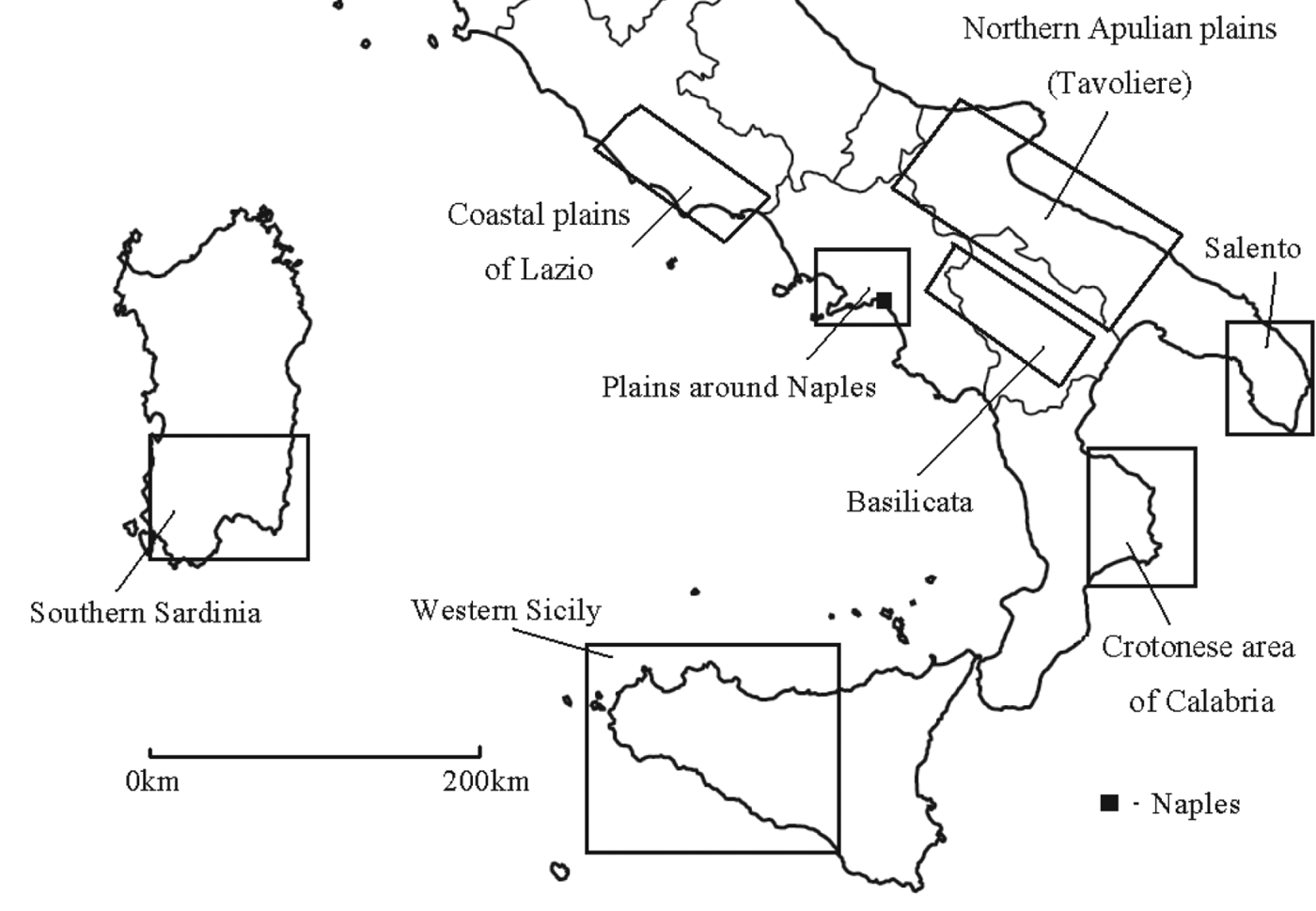
The ‘rambles’ of George Gissing through Southern Italy at the turn of the twentieth century led him to remark extensively on the topography. In particular, he frequently mentioned the miserable living conditions of the people he encountered who tended to live huddled together in large impoverished towns. His account is made all the more interesting by the fact that (a) Southern Italy is today more economically disadvantaged than Northern Italy with some of the poorest social and economic infrastructures in Western Europe,Footnote 2 and (b) this habitation pattern within large towns has been retained in large parts of modern Southern Italy. While alternative settlement patterns do exist in Southern Italy, including small villages and isolated farms, it is undeniable that the distribution of large concentrated towns is prolific.Footnote 3 It is also a settlement structure often seen in other areas of the Mediterranean such as in central and southern parts of the Iberian Peninsula, regions of mainland Greece, and in parts of Northern Africa. These large agglomerated settlements are often referred to as ‘agro-towns’, pointing to their essentially agricultural function (see Figure 1).
Approximate locations of main agro-town areas of Southern Italy. Even the concentrated towns vary in structure. In Western Sicily and the Northern Apulian plains there is a proliferation of very large agro-towns, while in areas such as Southern Basilicata (Lucania) there is still a pattern of concentrated settlement amongst mainly deserted countryside – but the settlements are much smaller in size.

The prevalence and persistence of agro-towns across Southern Italy (and indeed across large parts of the Mediterranean) are curious, but as yet are not well explained in the literature. This is unfortunate because understanding the roots behind the agro-town structure may shed some light on economic underdevelopment in Southern Italy and Spain, especially given that an explicit link has often been made between these towns and poverty. The Italian government in fact recognised the problems linked to persistent habitation within agro-towns in the South, and in the mid-twentieth century actually expropriated land from large estates to give to poor labouring families to entice them into living away from the towns.Footnote 4 The aim of this paper is to examine the roots and development of this quite distinctive Mediterranean settlement pattern by focusing explicitly on Southern Italy.
Initial work on agro-towns saw their formation as a logical grouping together of people in what was an essentially harsh environment. Early twentieth-century geographers highlighted poor access to water as a reason for settlement concentration.Footnote 5 Connected to this point, some geographers put precedence on the incidence and threat of malaria, particularly out on the plains.Footnote 6 After all, at the end of the nineteenth century, malaria killed around nine times more people in Southern Italy than in Northern and Central Italy combined.Footnote 7 Other scholars, even famous ones such as Max Weber and Fernand Braudel, alluded to the fact that many parts of Southern Italy were subject to widespread lawlessness and perpetual insecurity, and that living out in the countryside was not a ‘rational’ decision.Footnote 8 These arguments were not convincing at all. Many of the same conditions are found all over the world even today, in places not necessarily characterised by agro-towns. Environmental determinism was not a satisfactory explanation and causal conditions were not dealt with systematically.
A new group of scholars based largely (though not exclusively) around the disciplines of ethnology and anthropology later added some sophistication to these environmentally deterministic interpretations, however. These scholars generally framed the proliferation of agro-towns across much of the Mediterranean in a negative light, emphasising the role played by specific social and economic conditions such as high levels of inequality and widespread poverty.Footnote 9 In particular, scholars tended to link Southern Italian agro-towns with grain cultivation exploited through a series of large estates known as latifundia with minimal capital investment.Footnote 10 Latifundist estates tended to be hundreds and sometimes over a thousand hectares in area, cultivated almost entirely by agricultural labourers, often on short-term contracts and even on a day-by-day basis.Footnote 11
Other ‘negative’ interpretations of agro-towns in parts of the Mediterranean were linked to scholarly interest in the so-called ‘Mediterranean mindset’ or embedded cultural values. Towns were logical given a widespread culturally ingrained distaste for the countryside, whereby inhabitants exalted virtues of ‘urban’ life.Footnote 12 Connected with this was the apparent ‘regionalism’ of many areas of the South, where inhabitants had high levels of local patriotism and identification with their town of origin.Footnote 13 Such towns were home to internal discontent expressed in hostile entrenched class attitudes between landowners and labourers.Footnote 14 The inhabitants of these agro-towns apparently displayed animosity to other towns in the vicinity: indicative of a closed character.Footnote 15 Culture and politics came together most closely in the work of Robert Putnam, whose famous and somewhat controversial thesis posited that Southern Italy was a place where people had no concept of ‘citizenship’ or civic tradition.Footnote 16 The lack of trust apparently offered fertile conditions for the proliferation of mafia organisations,Footnote 17 led to the poor performance of Southern credit co-operations,Footnote 18 and led in a more general sense to the dysfunction of financial institutions.Footnote 19 Of course, these kinds of views on Southern Italy were informed by wider literature linking culture to economic performance.Footnote 20 Furthermore, Putnam's thesis at the time seemed convincing given that other works had suggested that agro-towns in Southern Italy lacked urban functions and municipal institutions,Footnote 21 and had no tradition of jurisdictional control over their rural hinterlands in the way that Northern and Central Italian city-states controlled their own surrounding countryside.Footnote 22
In that sense, the explanation of the agro-town in the Mediterranean came to be framed as an entirely negative story of inequality. Some might even say these ideas were placed within a narrative of Southern ‘backwardness’, a place of extreme social and economic polarities, a place without a civic consciousness, closed societies, and a place which never appeared to take the ‘step forward’ towards modernisation.Footnote 23 Southern Italy was portrayed as a place mired in antiquated feudal relations with little room for dynamic change; some historians emphasised the reinforcement of feudal powers in the transition to the early-modern period.Footnote 24 Agro-towns were linked in a general sense then (without real causal links established) to inequality, widespread ‘miseria’, and persistent institutional and economic structures.Footnote 25 Apparently they varied little in their economic function and one study even goes as far as to say ‘one agrotown resembled most others economically’.Footnote 26
The problem with this negative explanatory framework for the agro-town in Southern Italy was that it was rarely historically rigorous.Footnote 27 Thus, from the literature cited above, we actually cannot easily discern whether agro-towns are a recent phenomenon, only emerged within the past few centuries, or have medieval or even ancient antecedents. The long-term processes leading to the emergence of the agro-towns were not properly considered, with little explicit focus on chronology. Even some of the best sociological work identifying many different ‘types’ of Mezzogiorno (Southern Italy) failed to go back much before 1860.Footnote 28 In some cases historical sources were not used at all.Footnote 29
Fortunately, some of the best historical scholarship on Southern Italy in the past 30 years (driven forward by impressive work from the Istituto di Studi sulle Società del Mediterraneo based in Naples) has gone some way to addressing flaws in the previous methodology. In fact, in contrast to agro-towns being framed as an entirely negative story of Southern stagnation and backwardness, historians have focused on different regions of Southern Italy and shown agro-towns as part of a more ‘positive’ story. Biagio Salvemini in his study of an area of Central Apulia skilfully went back as far as the sixteenth century to show the view of agro-towns as being ‘backward’, immobile, economically irrational, dysfunctional, and with market weaknesses to be totally without foundation.Footnote 30 Salvemini instead highlighted how agro-towns fitted into an adaptive agricultural and economic system, subject to the pressure of international markets and changing balances between arable and pastoral lands.Footnote 31 Rather than a simplistic association between agro-towns and latifundia, scholars such as Angelo Massafra, Saverio Russo and Annastella Carino have shown a greater complexity of tenurial structure including the proliferation of micro-plots in the early-modern period.Footnote 32
Similarly, Eleni Sakellariou has shown that real urban centres emerged in Apulia as early as the fifteenth and sixteenth centuries – outward-looking places with high numbers of their inhabitants involved in non-agricultural activity and economically integrated into regional markets.Footnote 33 Apulian merchants and artisans actively participated in commercial exchange in a combination of regional and long-distance trading opportunities.Footnote 34 This was in contrast to a previous view likening Apulia almost to a ‘colony’ of the Venetian State, a significant client for agricultural produce.Footnote 35 Sakellariou's interpretation finds wider consensus with other scholars working on Apulia from the early-modern period.Footnote 36 Rather than emphasising the overarching grip of central political power from Naples or the economic might of Northern city-states,Footnote 37 these studies lend themselves more to economic development stimulated through local or regional interest groups.Footnote 38 Some of these towns even came to have some limited jurisdictional control over subordinate settlements in their rural hinterlands, not just in Apulia but also in Campania.Footnote 39 Scholars have even disputed the perceived wisdom that Southern Italian agro-towns had no municipal or urban functions, for example in parts of Salerno, and also in the towns of Reggio Calabria and Avellino.Footnote 40 One such function of these towns was increasingly to hold periodic markets and fairs.Footnote 41
The formation of agro-towns in Sicily was initially linked by Henri Bresc to a reliance on a complete grain monoculture dictated by the exploitation of southern markets by northern commercial elites.Footnote 42 However, exceptional work from Stephan Epstein was able to challenge Bresc's view by showing how Sicilian towns from the late Middle Ages onwards exhibited highly diversified economies and produced a vast array of items for regional trade.Footnote 43 In fact, Sicily benefited from a lack of urban monopolies or protectionism, institutional configurations that conversely held back regions such as Tuscany in the transition to the early-modern period.Footnote 44 The development of the South is no longer approached simply through a North–South paradigm.Footnote 45 Like Apulia, concentrated towns in Sicily also developed in a context of regional networks of trade.Footnote 46 Where previous ‘negative’ interpretations of the development of agro-towns had highlighted their almost exclusively agricultural and closed character, more recent historical work on Southern Italy instead highlights their diversified and integrated features.Footnote 47 Agro-towns apparently were products of more complex ecological systems, connected with wider territories and other networks of towns.Footnote 48 This same complexity in the Mezzogiorno has been extended to research at the household level too. Early work suggested that Northern and Central Italy were typified by larger complex households, while the small nuclear household was characteristic of Southern Italy;Footnote 49 however, later work has shown an entire diversity in household structure – proving a death-knell to big theories about the Southern Italian family.Footnote 50
Previous historical literature had suggested that Northern and Southern Italy had already begun to diverge in the Middle Ages.Footnote 51 However, the economic position of the Kingdom of Naples is now beginning to be revised in a general sense, particularly through important and skilled research by Paolo Malanima. Malanima has used comparative data such as wage series to show that before the end of the nineteenth century a gap between Northern and Southern Italy barely existed.Footnote 52 Similar lines of argument have been made with gross domestic product.Footnote 53 The notion of pre-industrial backwardness in the South has drastically been revised, also with support from Stefano Fenoaltea and Giovanni Federico. Even the scale of nineteenth- and twentieth-century latifundia has now been reconsidered, where new literature is highlighting a greater variety of modes of exploitation.Footnote 54 Old views of conservative landlords more concerned with ostentation than agricultural improvements have been challenged.Footnote 55 Furthermore, in 1860 numbers engaged in ‘industrial’ occupations were higher in the South than the North.Footnote 56 That is not to say that the pre-twentieth-century Mezzogiorno has now been painted as some sort of utopia; however, scholars have also recognised that at the time of Unification, Southern Italy displayed in many areas low levels of literacy and life-expectancy.Footnote 57
Thus, it is clear that scholarly literature on the economics and society of Southern Italy has become far more nuanced and sophisticated in recent years. A particular feature of these new interpretations is a greater appreciation of diversity and dynamism in economic activity in the South supported by a wide variety of institutional structures. However, this still poses some problems for understanding why the agro-town was a general phenomenon across a large part of Southern Italy (and the Mediterranean at large). We know now that Southern Italy was not as backward, isolated and conservative as once thought and exhibited a level of market integration, non-agricultural activity and tenurial complexity. But the point is so did many places in pre-industrial Europe – it did not mean that all these places were characterised by an overwhelming tendency for habitation within large towns, however.
Therefore, in this paper it is suggested that both the ‘negative’ older interpretations (of the anthropologist and ethnographic tradition) and the more ‘positive’ newer interpretations (of the historical, economic and archaeological tradition) can be correct. Agro-towns did proliferate in Southern Italy because of widespread and often extreme inequalities in the distribution of land. However, this does not mean that highly unequal land distribution within the South necessarily has to be logically connected with things such as latifundia or feudal structures or stigmatised by notions of ‘backwardness’ or an unchanging society. In that sense the old view highlighting Mediterranean inequality and the new views highlighting diversity and dynamism in the economic and social structures do not have to be mutually oppositional. Agro-towns may have been connected with high levels of inequality in the distribution of land in Southern Italy as a general phenomenon, but that does not mean there was just one ‘Southern Italian path’ towards inequality based around loaded terms such as ‘stagnation’, ‘conservatism’ or ‘backwardness’.Footnote 58
The first section of the paper will show that agro-towns tended to be connected with high inequalities in the distribution of land in Southern Italy, and this association between inequality and large concentrated towns goes back at least to the eighteenth century, but probably even earlier. The second section of the paper will show that agro-towns did not necessarily develop through latifundist agriculture and conservative structures, but were actually part of dynamic and flexible institutional structures for managing economy and agriculture. This is shown by a more detailed case study of two towns within Apulia: Ascoli Satriano and Locorotondo. As a general point, this paper supports the more recent work (mainly written in Italian) revising a previous image of Southern Italy as conservative and backward, and wishes to assert that point to an international audience that may not be able to access the Italian literature.
2. AGRO-TOWNS AND INEQUALITY
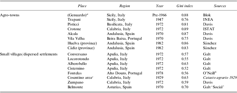
One of the problems with the early anthropological and ethnographic literature on inequality and agro-towns in the Mediterranean is that the link was rarely tested systematically – only merely suggested.Footnote 59 In this section, the connection between polarised distributions of landholding and the proliferation of agro-town structures is explored further using a comparative approach. Although the large concentrated town is a general phenomenon across large parts of Southern Italy, it has also been recognised that there are certain areas that do not conform to this model of settlement. In fact, there are some areas of Southern Italy that exhibited a more dispersed pattern of settlement – smaller villages and hamlets or scattered houses and farmsteads. The Murgia in Central Apulia, most of the Abruzzo, parts of Eastern Sicily, and the Cosentino area of Calabria certainly did not conform to the agro-town model.Footnote 60 The same is true of other parts of the Mediterranean such as Portugal: large towns may dominate in the Alentejo regions to the south, but further to the north small scattered hamlets dominate.Footnote 61 With that in mind, a simple question we can ask is whether the areas that did not conform to the typical pattern of agro-towns had more equitable distributions of land than those agro-town areas. This question is first addressed by taking some comparative examples of the Gini indices (see Table 1) for inequality in the distribution of property in the twentieth century from across the Mediterranean. For clarification, a value of 0 on the Gini index would represent a totally equal society (resources distributed evenly between all landholders), while 1 would represent a totally unequal society (resources consolidated in the hands of one interest group).
Gini indices for various places in the Mediterranean, twentieth century
a Parentheses indicate a pseudonym since the place's real identity is unknown.
b Own calculation from database of O'Neill's transcribed landholding survey.
c Including the same individual settlements as in Table 4 for the eighteenth century.
Sources: A. Blok, The mafia of a Sicilian village, 1860–1960 (Oxford, 1974), 251; INEA (Istituto Nazionale di Economia Agraria), La distribuzione della proprietà fondiaria in Italia (Rome, 1947); J. Davis, The people of the Mediterranean: an essay in comparative social anthropology (London, 1977), Table 6; ISTAT (Istituto Nazionale di Statistica), Secondo censimento generale dell'agricoltura, 25 ottobre 1970 (Rome, 1972); Sánchez, A. Rafael Peña and García, J. Rodríguez, ‘La concentración de la tierra en Andalucía en la década de los 80: una aproximación cuantitativa’, Estudios Regionales 46 (1996), 211–39; A. Galt, Far from the church bells: settlement and society in an Apulian town (Cambridge, 1991), 28–9; B. Juan O'Neill, Social inequality in a Portuguese hamlet: land, late marriage, and bastardy, 1870–1978 (Cambridge, 1987), 72–3; Catasto agrario 1929. Compartimento delle Calabrie. Provincia di Cosenza (Rome, 1936), fasc. 79; Galt, A., ‘Social stratification on Pantelleria, Italy’, Ethnology 19 (1980), 410.
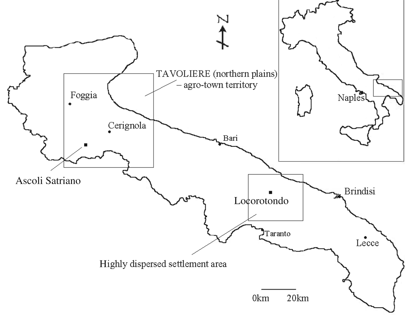
As a general trend from Table 1, it appears that agro-towns seem more frequently to be associated with higher levels of inequality in land distribution than villages and settlements in areas of the Mediterranean that do not conform to the agro-town pattern. The levels of polarisation in the agro-town areas were probably even higher than the values presented given that most of the Italian examples come after the land reforms of the mid-twentieth century. However, as mentioned already, one of the problems with the (often older) literature emphasising the connection between inequality and agro-towns in Southern Europe is that it is not always historically rigorous. We have plenty of data from the twentieth century on land distribution, but the point is that agro-towns did not suddenly appear in the twentieth century. Furthermore, the polarisation of resources was not a modern phenomenon – it probably had existed over a long period. If any kind of legitimate connection can be made between the proliferation of agro-towns and high levels of land inequality, we first have to take our comparative analysis back in time – preferably to the point in the past when the actual agro-town concentrated structure was beginning to take shape. This issue will be addressed by first looking in more detail at my own comparative historical case study of two areas in Apulia (Ascoli Satriano and Locorotondo) (see Figure 2), and then, second, these findings are fleshed out with some comparisons taken from other parts of Southern Italy.
Map of Apulia.
Ascoli Satriano is located on the edge of a large plain in Northern Apulia known as the Tavoliere. Archaeological evidence suggests that the earliest human habitation at Ascoli was around the ninth century BCE.Footnote 62 Similar dated earthworks have been found all over these plains.Footnote 63 In the Roman period, Ascoli (‘Ausculum’ as it was known thenFootnote 64) was a small cluster of habitations connected to a wider network of scattered villas operated by slave labour and focused on grain cultivation.Footnote 65 When the Western Roman Empire began to collapse in the fourth and fifth centuries, many of these farms were abandoned.Footnote 66 On the surface this fits with the influential thesis of Jean-Marie Martin, who framed early medieval settlement on the Apulian plains as a case of total depopulation with a retraction of cultivation and a re-growth of woodlands.Footnote 67 Nonetheless, there were some signs of continuity between the Roman and early medieval periods at Ascoli (on the plains in general).Footnote 68 An archaeological project at the villa of Faragola, 2 km outside the current location of Ascoli, has shown how the settlement readapted from an elite aristocratic residence into a small peasant village.Footnote 69
The medieval reconstruction of settlement in many parts of Apulia is difficult due to paucity of sources, and Ascoli is no different in that respect.Footnote 70 Essentially, the development of Ascoli from the high Middle Ages into the early modern period seemed to be characterised by total decline followed by re-emergence; perhaps unsurprising given the political struggles associated with the frontier region. Ascoli was subjected to the rule of the Vandals and Goths, Lombard princes,Footnote 71 and Byzantine and Norman lords from the fifth to the twelfth centuries, not to mention Saracen invasions in the late tenth century. Norman soldiers burnt Ascoli to the ground in 1082,Footnote 72 though it had been rebuilt in a different location by 1111 ‘without its previous beauty’.Footnote 73 The settlement was fortified by 1180.Footnote 74
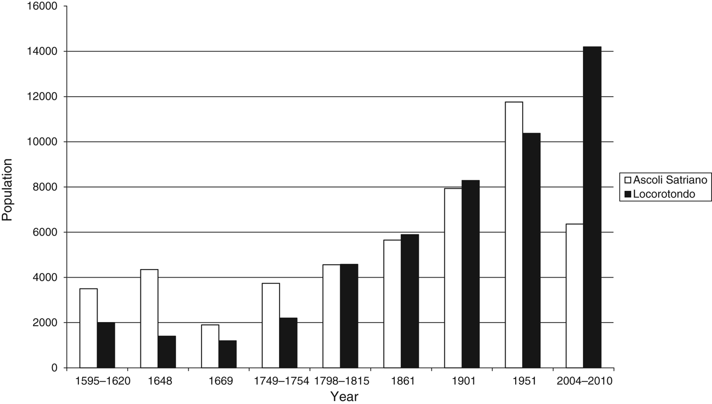
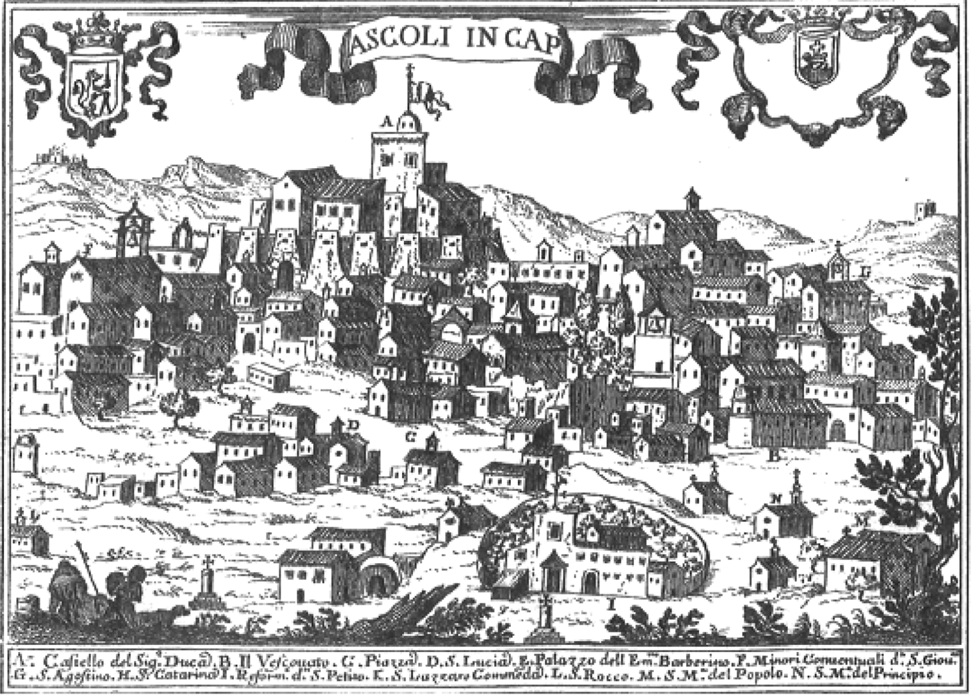
Late-medieval Ascoli is particularly difficult to reconstruct. Certainly we know that it began to descend as a feudal fee through aristocratic families who received lands and jurisdictions there in return for services rendered to sovereigns.Footnote 75 We also know that absentee landowners already had managed to secure land in the territory by the thirteenth century,Footnote 76 as happened all over this area of Apulia.Footnote 77 Settlement evidence is vague, however. One significant event was an earthquake on 5 December 1456, which totally destroyed Ascoli, and the surviving inhabitants had to relocate to a new spot where the current town is positioned.Footnote 78 The 1456 earthquake wreaked havoc in Southern Italy, with the number of victims estimated in Molise, Campania, Abruzzo, Basilicata and Apulia between 30,000 and 100,000.Footnote 79 After relocation, Ascoli grew from 420 households in 1532 to 870 households by 1648 (a population of 4350) (see Figure 3), enough to warrant ‘small town’ status, though we cannot be sure of the location of these houses. After 21 years, however, Ascoli was reduced to less than half of its former size, badly hit by outbreaks of pestilence with a great loss of human and animal life.Footnote 80 Nonetheless, a sketch made of Ascoli in 1703 (see Figure 4), shows the general form of a concentrated town, even though the population in 1709 was half of what it had been before the plague epidemic, and only narrowly more houses than in 1532.
Population trends in comparison, Ascoli Satriano and Locorotondo, 1595–2010. Sources: L. Giustiniani ed., Dizionario geografico ragionato del Regno di Napoli di Lorenzo Giustiniani, ii (Naples, 1797), 8–9, 282; N. Colclough, ‘Family and the spatial distribution of kin in eighteenth century Ascoli’, http://lucy.ukc.ac.uk/jb6/archives/ascpaper/ascfr.html; A. Ventura ed., Onciaro della città di Ascoli 1753 (Foggia, 2006); ISTAT (Istituto Nazionale di Statistica), Catasto agrario (1929-VIII. Compartimento delle Puglie. Provincia di Bari (Rome, 1933), no. 71; Secondo censimento generale dell'agricoltura; Dodicesimo censimento generale della popolazione (Rome, 1983); Archivio di Stato di Bari, 1749 Catasto Oncario di Locorotondo; A. Mele, Una famiglia in ascesa nel Regno di Napoli. I marulli duchi di Ascoli tra Sei e Settecento (Foggia, 2000), 138–41.
Ascoli Satriano in 1703. Source: G. Pacichelli, Il Regno di Napoli in prospettiva... (Naples, 1703).
By the time of the Catasto Onciario (a fiscal assessment of property in the Kingdom of Naples) in 1753, Ascoli had surpassed the houses recorded one century previous.Footnote 81 Nearly every house was recorded within the town centre or a contrada (neighbourhood) near the walls. The transmission of property through women via marriage contracts had led to the establishment of many ‘new’ nuclear households (77 per cent of all households in 1753);Footnote 82 however, houses were positioned very close together as daughters inherited houses within the same contrada as their parents.Footnote 83 The only houses far from the walls were the large farms (masserie) belonging to elite landowners.Footnote 84 Many of these masserie were located in exactly the same spots as former Roman fattorie and villas, and perhaps also failed villages from the late Middle Ages.Footnote 85 Despite the obvious concentrated structure of the town, the Onciario probably concealed a level of settlement in the countryside not systematically recorded by the assessors.Footnote 86 Nonetheless, throughout the eighteenth and nineteenth centuries, Ascoli Satriano simply became bigger and more concentrated – hindered only in brief phases such as the typhus epidemics of 1764–1767 and 1815–1817.Footnote 87
Locorotondo was located further south to Ascoli, on a raised rocky inland plateau in Central Apulia known as the Murgia. Locorotondo also knew human habitation from around the ninth century BCE, but the first settled farming communities probably emerged much later around the fifth century CE.Footnote 88 Saracen invasions and Lombard counter-attacks caused destruction of the principal coastal settlements of Brindisi, Bari and Taranto, and forced people into the wooded Murgia to seek refuge.Footnote 89 As with Ascoli, there is limited documentary material to reconstruct the medieval settlement development of Locorotondo. Around 1086, the Count of Conversano founded the Abbey of S. Stefano of Monopoli, giving them amongst other feudal property, the fee of Casale S. Giorgio, later to become Locorotondo. The Knights of Jerusalem fortified the settlement in the fourteenth century, and from the fifteenth century, Locorotondo descended through the hands of various aristocratic families.Footnote 90
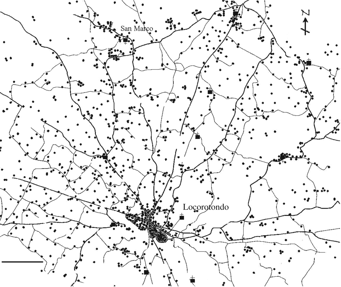
The demographic development of Locorotondo was less dramatic than the trajectory of Ascoli, as seen from Figure 3. In 1648, it was less than half the size of Ascoli, yet Locorotondo was also less severely hit by bouts of pestilence in the mid-seventeenth century that had been so disruptive in Ascoli.Footnote 91 Locorotondo was less afflicted by cattle plagues, as its more rocky and wooded environment did not support this sort of pastoral economy. The epidemic evened out population differences between the two places, and from the late seventeenth century onwards both settlements followed a similar demographic trajectory. Locorotondo grew during the eighteenth century, though not into a concentrated town like Ascoli. Certainly there was a town centre tucked away behind the walls; home to the church, taverns, and artisan shops. However, this coexisted with a level of dispersed settlement. Clusters of trulli (conical stone houses) known as ‘jazzeleri’ were mentioned by notaries, which were clearly out in the countryside.Footnote 92 By the census of 1811, 37 per cent of inhabitants were living outside the walls and in new areas (nuovi borghi).Footnote 93 The scattered pattern of settlement has continued to the modern day, a contrast to the stereotypical vision of the concentrated town in the Mediterranean. In 1971 over half the population lived outside the walls, as shown in Figure 5.
Distribution of dispersed trulli in Locorotondo, end of the twentieth century. Adapted from: A. Liuzzi, La Murgia dei Trulli: lineamenti caratteristiche, sviluppo economico e civile (Martina Franca, 1981), 150.
Although Ascoli and Locorotondo (like many Apulian towns) experienced strong demographic growth after the shock of the mid-seventeenth-century plague, only Ascoli redeveloped into a concentrated town. As noted in the Introduction, some of the older, more negative literature suggested that agro-towns were linked to high levels of inequality and poverty in the South. However, can the link be confirmed much further back in the past? In that sense, was Ascoli more unequal than Locorotondo in the eighteenth century, during its phase of settlement reconstruction and demographic recovery?
By making use of the fiscal registers from the mid-eighteenth century, the answer suggests this was the case. The Catasto Onciario was a register of taxable property combined with a census of households for the Kingdom of Naples, mandated by the Bourbon King Charles VII of Naples (Charles III of Spain) in order to make the tax system more efficient and equitable.Footnote 94 The declarations of property varied from settlement to settlement – the first ones were conducted in 1741 while some were not completed until 1788.Footnote 95 One of the helpful features of the Onciario was that it included all households, regardless of whether they had land or not, thus making it a good source for reconstructing inequality.Footnote 96 Some caution needs to be taken nonetheless in the sense that the new tax was based on simple estimates rather than sophisticated measuring.Footnote 97 By making databases of the Onciario entries, it was confirmed that the agro-town of Ascoli was far more inequitable than the dispersed settlement of Locorotondo. Ascoli received an astonishing 0.97 on the Gini index for distribution of land (including all types of land: arable, pastoral, vineyards, and olives) compared with 0.77 in Locorotondo.Footnote 98 The scale of inequality in Ascoli can be further highlighted by comparing Gini indices elsewhere in Italy in the early-modern period. For example, in Piedmont in Northern Italy, the small town of Ivrea had a Gini index that oscillated between 0.6 and 0.7 all the way from the late fifteenth to the late seventeenth century.Footnote 99 Even when compared with the famously inequitable distribution of property in the fifteenth-century Florentine contado (a Gini index of 0.8), Ascoli exhibited far greater levels of polarisation.Footnote 100 Gini indices between 0.65 and 0.75 were quite common for small towns and rural areas across pre-industrial Western Europe from the fourteenth up to the eighteenth century.Footnote 101
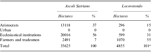
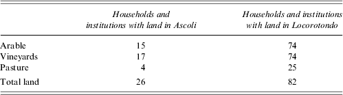
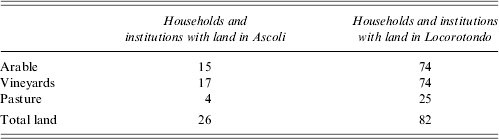
Thus inequality in Ascoli proved sharp; 1 per cent of Ascoli households and institutions listed owned 58 per cent of the land. Furthermore, 93 per cent of the land was in the hands of feudal lords such as the Duke of Ascoli, lesser aristocratic families, or absentee ecclesiastical institutions in Ascoli, leaving just 7 per cent in the hands of local peasants, labourers and tradesmen (Table 2). In Locorotondo, 55 per cent of the land was in the hands of local agriculturalists and tradesmen (Table 2). Three-quarters of the population had no access to land at all in Ascoli compared with just under a fifth in Locorotondo (see Table 3). In fact, most of the Ascoli residents did not even own houses (just a quarter of the households did), often renting a room from ecclesiastical institutions or wealthy aristocrats who monopolised real estate in the town.
Social distribution of land in Locorotondo and Ascoli Satriano, 1749–1753

a Percentage does not add up to 100 due to rounding.
Sources: A. Ventura ed., Onciaro della città di Ascoli 1753 (Foggia, 2006); Archivio di Stato di Bari, 1749 Catasto Onciario di Locorotondo.
Access to land in Locorotondo and Ascoli Satriano, 1749–1753 (%)
Sources: A. Ventura ed., Onciaro della città di Ascoli 1753 (Foggia, 2006); Archivio di Stato di Bari, 1749 Catasto Onciario di Locorotondo.
The Gini index for Locorotondo was much lower than that of Ascoli, although at 0.77 it was still quite high, especially if we compare it with the values in Table 1 based on the twentieth-century land distributions. However, a note must be made on this. Locorotondo may have had a Gini index of 0.77 in 1749, but this value was stretched somewhat by the large amount of forest in the hands of the Duke of Martina Franca (without the forest it was 0.7). Furthermore, by the twentieth century this general value was as low as 0.55 (see Table 1). The reason can be put down, as Anthony Galt has expertly demonstrated, to the dissemination of emphyteutic leases from the mid-eighteenth century onwards.Footnote 102 These contracts specified to the tenant that they must improve the property and this was common to the Mediterranean.Footnote 103 Initially ecclesiastical institutions but later lay feudal aristocrats decided to offer their land out on long-term heritable leases with the stipulation that the receiving peasant tenants had to improve the land by preparing the soil for viticulture.Footnote 104 The plan of the landlords was that after the initial labour-intensive and back-breaking work made by the tenants, they would take the land back into hand – after 20 to 30 years. However, due to the weaknesses of the elite landowning class (explained later), this never happened. Landlords lost their grip and security on the land, and eventually it was actually owned by the peasants themselves. Vineyards as the backbone of small peasant property in Locorotondo were distributed much more equally than land taken in its entirety in 1749, with a Gini index of 0.56 in comparison with the 0.77 mentioned above. In that sense, the proliferation of the lease allowed a larger proportion of Locorotondese inhabitants to gain access to their own land, with many of the farmers actually deciding that it was in their interests to build their stone trulli out in the fields next to their vineyards.Footnote 105 In fact, the inheritance practice in Locorotondo shifted in the eighteenth and nineteenth centuries in line with these changes: real estate in the town transferred to the daughter upon marriage was replaced by a system whereby sons received a rural trullo out in the countryside while daughters received cash payments.Footnote 106 This demonstrates the interconnectivity of land access and settlement development, as well as explaining reduction of the Gini index in Locorotondo between the eighteenth and twentieth centuries.
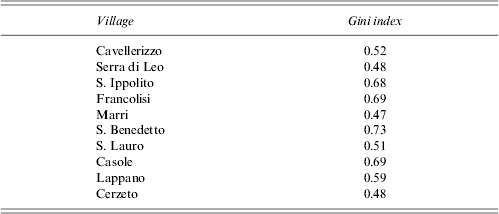
Thus, the connection of inequality in the distribution of land and the proliferation of agro-town structures is suggested by this comparative historical example. However, further historical data taken from other parts of Southern Italy also support this link. For example, the large concentrated town of Calopezzati in Calabria knew a Gini index of 0.87 for distribution of land in the eighteenth century.Footnote 107 Further calculations of transcribed catasti for a cluster of small towns close to Naples in the Campania (Crispano, Frattapiccolo and Pomigliano d'Atella) also showed a highly skewed distribution of land in the eighteenth century, all recording Gini indices close to 0.9.Footnote 108 Of the households or institutions listed in the Onciario for Crispano, 86 per cent worked less than 2 hectares, and well over half of those recorded neither owned nor had any access to land through lease. These values can be contrasted with the author's database of Gini indices taken from the Cosentino region of Calabria,Footnote 109 which was a part of Southern Italy identified by Pino Arlacchi as not conforming to the agro-town model. Here people lived in small villages and hamlets.Footnote 110 As Table 4 shows, the distribution of land here was much more equitable, with Gini indices even below 0.5 in places. Some of the Cosentino achieved the same level of equality as the famously egalitarian mountain villages studied by Robert Netting in the Swiss Alps.Footnote 111
Gini indices for villages in the Cosentino area of Calabria, mid-eighteenth century

Source: Archivio di Stato di Cosenza, III. Catasti, notai e archivi non statali, Catasti, Catasto Onciario (various nos).
In sum, it has been argued in this first section that large concentrated agro-towns were more likely to exist in parts of Southern Italy that were characterised by high levels of inequality in the distribution of land. By the same token, those settlement structures that diverged from the general pattern of agro-towns tended to have much more equitable distributions of land. This association was not made simply with contemporary or twentieth-century values, but also was placed within the chronological development of the agro-town structure and seemed to be confirmed by a comparative historical case study in Apulia, supported by some additional data from Campania and Calabria.
3. HISTORICAL PATHS TOWARDS INEQUALITY: EXPLORING ASCOLI AND LOCOROTONDO FURTHER
The notion that agro-towns were in some way connected with inequitable distribution of land conforms to a previous (not particularly historicised) view perpetuated by many international ethnographers and anthropologists, who highlighted inequality and polarisation as some of the fundamental features of life in the Mediterranean. However, this next section shows that while agro-towns and inequality are probably linked (historically), the old negative view of Southern Italy as a ‘backward’ or conservatively minded place, hindered by long traditions of feudalism, latifundia, and absence of civic consciousness, does not necessarily have to follow. As is demonstrated in this section through comparative analysis of Ascoli and Locorotondo in Apulia, the perpetuation of an inequitable distribution of land could have dynamic and diverse origins. Thus, an older ‘more negative’ literature written mainly by international anthropologists and ethnographers and a new more historically grounded literature (written mainly in Italian) and portraying pre-industrial Southern Italy as a more dynamic place do not need to be mutually opposed.
After learning in section 2 that Ascoli Satriano was a place of extreme inequality in the distribution of land in the eighteenth century, we might be tempted to picture the development of Apulian agro-towns in a negative light with an emphasis on large latifundist estates and the impoverishment of a mass rank of wageworkers. This is the kind of image portrayed by Frank Snowden when he described the late nineteenth- and early twentieth-century ‘company towns’; places like Cerignola or Andria where poor people were crowded into rented hovels in terrible living conditions, often with no windows and located underground.Footnote 112 These kinds of conditions gave rise to endemic and epidemic diseases, as described also by Snowden for Barletta in 1910.Footnote 113 In a report from 1889, it was noted ‘misery had become more terrible’. One peasant was recorded as having died from starvation leaving three children behind, while the very next day another agricultural worker had fallen into the public highway exhausted by lack of food.Footnote 114 The troubling aspect of the report was its note that such cases were so common, it was becoming almost impossible to provide support to the destitute – the town of Andria was described as entirely ‘over-populated’.
However, while latifundia and the masses of impoverished agricultural labourers may have characterised the environment of many Apulian agro-towns in the late nineteenth century, it was not clear that the actual development of the concentrated agro-town structure occurred in these conditions. Concentrated agro-towns and inequitable distribution of land on the Northern Apulian plains actually were established and perpetuated in a context of an ecologically managed mixed system of arable and pastoral farming with high levels of capital investment in large flocks and herds of animals. Ascoli in particular was crystallised into a real commercial and trading centre based around urban functions.Footnote 115 While agro-towns and inequality were locked into this system, managed centrally through the government in Naples, the more equitable and dispersed settlements of Locorotondo (and more generally on the Murgia) had autonomy over their own adaptable strategies – achieving control over their own land thanks in combination to greater independence from Naples and internal weaknesses of their elite feudal landlords. Locorotondo became orientated towards international markets through the coastal ports of Apulia rather than the overarching coercive arm of Naples.
3.1 Ascoli and the plains of the Tavoliere
The large concentrated towns such as Cerignola, Troia, Foggia, Lucera, Candela, Andria and Ascoli Satriano on the northern plains of Apulia (the Tavoliere) emerged in a context of strict economic and agricultural management by the Royal Customhouse of Naples. The system was based around a rigorous supervision of transhumant sheep farming between the Apulian plains and the mountains of the Abruzzo.Footnote 116 Transhumance between the two regions had Roman origins, though the system retracted in the early Middle Ages with the collapse of the long-distance trading networks.Footnote 117 When the Normans arrived in Apulia, transhumant sheep farming probably picked up again (from around the eleventh century onwards), although the Royal Customhouse only formalised the institutions necessary for its management in 1447.Footnote 118 Some evidence points to local cloth production in parts of late-medieval Northern Apulia.Footnote 119
The rationale behind the Royal Customhouse of Naples was to create a balance between arable and pastoral land on the Tavoliere.Footnote 120 Alongside the Castilian Mesta, it was Europe's largest managed pastoral economy. Privately owned arable land was grazed during fallow periods, while royal pastures were never cultivated. It that sense, it was an early exercise in environmental sustainability and a way of avoiding ecological degradation. It also lent itself to flexible manipulation in the economic interests of the Neapolitan political and commercial elite. Wool and wheat were cash products that were to be sold in Naples, and, fortunately for Ascoli, it was located on a key overland transport link through the Basilicata to Naples.Footnote 121 Naples was one of the most populous cities in Western Europe before the plagues of 1656; therefore the ratio between arable and pasture fluctuated with the trends of demand and prices for agricultural goods.Footnote 122 Grain fed the kingdom while taxes on sheep provided its riches.Footnote 123 Apulia accounted for over a fifth of total grain imported into Naples between the mid-1500s and the mid-1600s, and in 1486 around 655,200 kg of grain were shipped from Manfredonia in Northern Apulia to Naples.Footnote 124 Tax exemptions and privileges granted by Naples to certain Apulian centres eased the export of grain.Footnote 125 Of course, the ratios between arable and pasture were not entirely dictated by demand. For example, the pestilences of 1656 in Northern Apulia led to an entirely contracted labour force, thereby halting any trend towards large-scale arable cultivation.Footnote 126 Elite landowners quickly shifted investment strategy towards sheep farming with smaller labour-intensive demands – an extreme case being the estates of the Prince of Melfi.Footnote 127 However, when the population began to increase on the plains again, pressure was once more put on producers to bring more land into grain cultivation.Footnote 128
The incipient town structure on the Northern Apulian plains had its roots in the rigorous management of the Tavoliere by Naples from its regional base in Foggia. First of all, the building of farms and houses out in the countryside became entirely restricted. In that respect the Tavoliere became depicted as a barren wilderness, comparable with the steppes of Central Asia. It was the second biggest province in the Kingdom of Naples in terms of area, and frequently the least populous in the early-modern period.Footnote 129 Land became divided into locazioni, each comprised of a number of isolated farms known as masserie. Livestock farms were more complex than grain farms, took up more space, and included a wider range of buildings such as dog kennels, animal stables, sheep pens, cheese-processing sites and threshing floors.Footnote 130 In particular, the complex belonging to the abbey of S. Leonardo di Siponto at their Feudo di Torre Alemanna had all these things as well as taverns, olive pressesFootnote 131 and bakeries inside an almost fortified design.Footnote 132Locazioni were also subdivided between smaller huts (capanne), which belonged to shepherds and often included a church nearby. In sum, the potential for local inhabitants to construct their own habitations where they wanted on the plains was limited. The point is reinforced by the fact that on the Tavoliere lie the remnants of former villages, abandoned between the fourteenth and sixteenth centuries. Up to around the fifteenth century, this sort of settlement structure was possible on the plains of the Tavoliere, but was quickly destroyed when the Royal Customhouse management of agriculture was institutionally formalised.Footnote 133
Second, the inequitable distribution of land on the plains was often crystallised through Neapolitan state control of the regional economy. From the sixteenth century onwards, Naples favoured the large landowners and those with the larger flocks, and they were often given the best grazing lands.Footnote 134 The best grazing lands were very close to Ascoli, especially the locazioni of Orta and Ordona, because they had previously gone under the plough.Footnote 135 The skewed property distribution came to be locked in over the long term and made more inequitable from the sixteenth century onwards with smallholders put at a constant disadvantage.Footnote 136 The State in fact on occasion supported the expropriation of small cultivators – reintegrating the land as part of larger pastoral complexes.Footnote 137 This was in contrast to the belief of the Royal Customhouse that they were ‘pacifying’ the countryside and promoting harmony through balanced justice and good government.Footnote 138
In particular, the commercialised pastoral economy that emerged in Ascoli came to be entirely polarised in the hands of powerful interest groups in the eighteenth century – many of whom employed armed retainers to protect their flocks and land.Footnote 139 In Ascoli, the Catasto Onciario recorded nearly 30,000 animals, a significant amount in comparison with the 2000 found in Locorotondo, and almost 95 per cent of these were goats or sheep. The pastures had the most inequitable distribution of all the land – only 3 per cent of the population had access to grazing in the eighteenth century, while the average size of a pastoral landholding belonging to an individual or institution was over 200 hectares.Footnote 140 Only 15 per cent of the population had access to an animal, and it was only this high because some of the impoverished labourers had a donkey to carry goods from the fields. Of all animals, 85 per cent were consolidated in the hands of the top 10 landowners in Ascoli. Some of these landowners had extremely large herds, such as the Marquis of Basilicata, Don Alessandro Rinuccini, who by himself owned a third of all animals listed in the whole of Catasto including 10,000 sheep amongst others. These animals were grazed out on masserie belonging to the Locazione del Feudo, west of Ascoli and centred on the present-day hamlet of Palazzo d'Ascoli. Until the late seventeenth century, these enterprises were run by the Crown, which specialised in horse breeding for the army; however, they had come into the hands of the Marquis through royal debts.Footnote 141 These large pastoral enterprises were frequently in the hands of absentee institutions since 80 per cent of the pastures belonged to non-residents, often ecclesiastical institutions. The Jesuits controlled many of these commercial estates until they were dissolved by royal decree in 1767.Footnote 142
Nonetheless, while inequitable distributions of land and power might account for restrictions on habitation in the countryside of Northern Apulia in the early-modern period, it cannot explain why the development of capital-intensive and labour-extensive forms of commercialised pastoral farming occurred simultaneous to the intense growth of these concentrated towns after the pestilences of the mid-seventeenth century. How can we account for the large inward migration into Ascoli in the eighteenth century and where was the attraction? Indeed, 32 per cent of households in the Onciario of 1753 were living in Ascoli as immigrants, indicative of high mobility. Unfortunately, while we know the place of origin for all of these people (people came from all over Apulia and Basilicata to live and work in Ascoli),Footnote 143 the Catasto did not record occupations for immigrants. They were not all poor labourers looking for work, though. Some were referred to as ‘magnificent’, indicative of elite status, while others were doctors, clerics and widows.Footnote 144
It seems that the town of Ascoli expanded its population as a result of its well-developed trading and commercial sector – essentially an urban sector. Obviously this kind of situation contrasts entirely with some of the views crystallised by Putnam, who emphasised the agricultural character of Southern Italy, its sense of a closed community, and its lack of civic amenities. Ascoli blossomed in the eighteenth century despite its extreme inequality in the distribution of land as traders and artisans were able to provision the large estates and transhumant pastoralists with produce.Footnote 145 Neville Colclough showed through a list of hearths from 1728 that only about 35 per cent of the population worked on large estates, and these were not always grain. Actually, more of this kind of work was taken on by temporary seasonal workers from the Southern Apulia and the Central Uplands, who did not own property in Ascoli and rented rooms from wealthy aristocrats in the town, taking up notarised six-month contracts to work the estates.Footnote 146 Agricultural labourers made up a minority of the population. In fact, Ascoli had a high amount of inhabitants working outside agriculture, either in professional or clerical roles, or in mercantile or industrial roles as craftsmen or apprentices. Colclough's values from 1728 suggested that almost half the people in Ascoli worked in the ‘urban sector’,Footnote 147 and this is supported by my data from 1753 which recorded 40 per cent of the inhabitants in urban occupations.Footnote 148 Some of those in the ‘urban sector’ supported their trades with work on micro-plots of vines attached to the town walls.Footnote 149 Elsewhere on the agro-town plains such as at Orsara di Puglia, high levels of non-agricultural labour have been found.Footnote 150 These values can be contrasted with Locorotondo where only 14 per cent of households were involved in non-agricultural occupations in the mid-eighteenth century or Santo Marco dei Cavoti in Northern Basilicata (an area characterised by small villages and dispersed farms) where only 10 per cent of the heads of households were classed as ‘artisans’.Footnote 151
Thus, the large concentrated town structure of Ascoli was crystallised in place a long time before monoculture and latifundist estates started to dominate on the Tavoliere. In 1806 the Royal Customhouse of Naples and its management of the Apulian plains collapsed in line with a Europe-wide ideological move away from communal property forms at the end of the eighteenth century.Footnote 152 The same solution was devised for the Sila Forest in Calabria.Footnote 153 Neo-Malthusian and neo-liberal ideological reforms necessitated a dismantlement of a system deemed antithetical to new visions of modernity.Footnote 154 This had been preceded by the writings of a number of ‘enlightened thinkers’ such as Antonio Genovesi, Gaetano Filangieri and Giuseppe Galanati discontented with the persistence of old feudal structures across the Kingdom of Naples.Footnote 155 One such Neapolitan reformer, Ferdinando Galiani, went as far as to describe the collective transhumance system in Apulia as ‘barbarous’ and having parallel nowhere across ‘civilised Europe’.Footnote 156 However, the collapse of the Royal Customhouse did nothing to change inequitable property distribution on the Tavoliere. In fact, it exacerbated inequality, since ‘communal land’ was simply divided up and sold to the highest bidders at public auction.Footnote 157 In that way land was consolidated into the hands of already-wealthy interest groups in Northern Apulia: former feudal lords and barons, urban entrepreneurs and property speculators.Footnote 158 The same skewed process happened in Sicily when newly wealthy rent collectors expropriated communal parcels allocated to peasants as compensation.Footnote 159 Thus, finally the labour-intensive and environmentally exhaustive system of latifundia dominated the region towards the late 1800s – a far cry from what had come before.Footnote 160 Old sheep-orientated masserie were readapted for this purpose.Footnote 161 As production shifted, flocks of immigrant workers came to fill the suburbs (vineyards and meadows were converted into habitations) – yet this labour migration merely added to a pattern of towns already fixed in place in another economic and ecological context.
3.2 Peasant power and adaptive strategies in Locorotondo
The importance of some of the conditions that led to the perpetuation of inequitable land distribution and agro-towns on the Northern Apulian plains, including the strong coercive arm of Naples and the imposition of a centrally managed agricultural system, can be further highlighted through comparison with areas of Apulia that did not conform to the same land distribution and settlement structure. It is shown in this section that these divergent developments in Locorotondo were testament to a different colonisation context, which led in turn to a weaker group of elite landlords who by the eighteenth century had to concede land to peasants through emphyteusis rather than consolidate large estates. Furthermore, Locorotondese peasants had more room to follow adaptive strategies through viticulture, since they avoided the strong coercion from the government of Naples and orientated production through the coastal towns of Apulia itself.
In Galt's book on Locorotondo, he emphasised the importance of widespread access to land and the diffusion of emphyteutic leases as the main reasons why settlement structure developed differently from the agro-town pattern seen elsewhere in Southern Italy.Footnote 162 This argument was highly convincing. What he failed to show, however, were the mechanisms behind these developments in Locorotondo. His argument was that landlords had trouble finding labour to work large estates in the eighteenth century, putting them off grain cultivation, and instead they resorted to emphyteutic leasing of vineyards to local peasants.Footnote 163 On the surface the argument made sense, particularly given that emphyteutic leasing had been used in Sicily in the sixteenth century with the explicit intention of bringing people to underpopulated areas.Footnote 164 His rationale on further inspection, however, was not logical. Although the population of Locorotondo was behind that of Ascoli by some way in the mid-eighteenth century, a demographic boom between 1750 and 1850 meant that by 1861 Locorotondo actually had more inhabitants than Ascoli (see Figure 3). Furthermore, the territory of Locorotondo was one-eighth of the size of Ascoli. Given this information, it is really doubtful that Locorotondo landlords would have found it difficult to find workers for hypothetical estates, considering that large estates were formed elsewhere in places with lower population densities.
Instead, the more equitable property structure seen in Locorotondo had its roots in the first instance in its colonisation and reclamation context. In Locorotondo, local peasants were by the sixteenth century colonising the woodlands and wastes with their own private enclosures. At the time when the town of Locorotondo bought its hinterlands from the Royal Court in 1566 (establishing its territorial borders),Footnote 165 the settlement was located in the middle of a large common territory that ran from Monopoli on the coast to Ostuni in the south-east.Footnote 166 The communities of nearby Martina Franca, Fasano, Cisterino, as well as Locorotondo, benefited from the common rights of grazing and collection of wood.Footnote 167 Sixteenth-century fulling mills existed in various places along the River Cervaro, very close to this territory, indicative of silvo-pastoral farming.Footnote 168 Around the mid-sixteenth century, however, inhabitants began to encroach into the commons, something that the Royal Court struggled to prevent. It was noted in the document from 1566 that much of the land was now enclosed and had vineyards belonging to farmers from Locorotondo and Martina Franca.Footnote 169 The document also mentioned two jazzèleri, Trito and S. Marco, showing how the seeds of dispersed settlement had already been laid. It was also noted that it was now legal to plant vineyards and gardens under private ownership, which effectively meant that by the eighteenth century all common land ceased to exist in Locorotondo.Footnote 170 This early encroachment by local farmers allowed them to build up a firm property base by the eighteenth century, which gave them stronger foundations in opposition to feudal lords. Indeed, the fact that a wider section of the population in Locorotondo received access to land through emphyteutic concessions from the 1700s onwards was down to the fact that the elite landowners in Locorotondo were much weaker than those to be found in other parts of Southern Italy, such as Ascoli. In Locorotondo, there was a greater power struggle between social groups than seen in typical agro-town areas.
The fee of Locorotondo had belonged to the Duke of Martina, Francesco Caracciolo I, since 1645; it was bought from another noble family of the town of Monopoli.Footnote 171 The Duke was the largest landowner in Locorotondo in 1749 with 355 hectares to his name (7 per cent of the territory). Proportionally, the Duke of Ascoli, Don Sebastiano Marulli did not hold much more – around 9 per cent of the total. However, the territory of Ascoli Satriano was much larger than that of Locorotondo (the 9 per cent corresponded to 3290 hectares), and thus comprised an estate around 10 times the size of that of the Duke of Martina Franca. Furthermore, the quality and fertility of the Locorotondo land were significantly lower than the lush plains around Ascoli. The Caracciolo family did have estates outside Locorotondo in the nearby regions, but at the same time the Marulli family of Ascoli similarly had masserie in other parts – particularly to the south.Footnote 172 The landed weaknesses of the large landowners in Locorotondo in comparison with the agro-town regions of Apulia are shown by the fact that the top 10 Locorotondese landowners only comprised 14 per cent of the total land, paling in comparison with the 58 per cent in the hands of the top 10 Ascoli landowners. The Duke of Martina Franca (lord of Locorotondo) had all things one would associate with feudal estates: a castle, a tavern, a butchery, craft shops, furnaces, a mill – even underground snow-storage facilities.Footnote 173 The Duke of Ascoli, however, had all these things but in greater quantity.
The weak position of the Locorotondo landlords translated itself into jurisdictional problems, especially for the feudal lord, the Duke of Martina Franca.Footnote 174 The relationship between the local municipal authorities (università) and the aristocratic elite was symptomatic of the general weakening of the power of large landlords. Before 1550, the municipal government tended to support the prevailing aristocratic and baronial groups. However, as the woodlands began to be cleared and more investment was put into agriculture, the municipal authorities instead began to align themselves away from the barons and more towards serving the interests of the local community that was expanding in size and influence.Footnote 175 As the Duke of Martina Franca began to see his jurisdictional powers over Locorotondo waning in the eighteenth century, he increasingly took recourse to ancient rights found in old documents in an attempt to stem the general trend towards heightened municipal autonomy.Footnote 176 In 1754, conflict had led the Duke to make demands on the municipal authorities, arguing that they owed him three annual sums:Footnote 177 first, a sum of 48 ducats for ovens, mills and herbage, as agreed in 1502 and 1509 with previous barons Alberico and Alessandro Carafe; second, a sum of 200 ducats as a tribute for autonomy afforded the municipal authorities by the barons; third, a sum of 50 ducats as a direct charge to the municipal authorities covering a fine for the marriage of daughters in the territory, and also as compensation for underpayment by the università for half the land bought from former barons, the Loffredo family. The weak position of the feudal lords was highlighted by the fact that the università refused outright to pay these sums, and, in fact, turned the claims around by suggesting that they themselves had been overcharged over the years. Eventually the Duke lost his tithe of a twentieth,Footnote 178 and while the feudal lords renewed their complaints in 1785, by this time they were thoroughly beaten.Footnote 179 During the course of the eighteenth century, the municipal authorities stopped paying rent to the Duke, the decime (tenth) and twentieth had disappeared, and total ducal income in 1794 was down from its level in 1667.Footnote 180 Demographic expansion and rising prices further reduced the relative value of feudal revenues.Footnote 181
In summary, the more equitable distribution of land and the divergence from an agro-town settlement pattern in Locorotondo had its seeds set in its particular colonisation context and the more equitable power balance between interest groups. These jurisdictional and landed weaknesses of the elite landlords led them down the route of emphyteutic leasing in the eighteenth century. What is more, the weaknesses of the landlords also led the emphyteutic leases to become almost heritable, where landlords lost their grip on property to peasants and emphyteutical income eroded with inflation over the long term.Footnote 182 The same process has been traced for parts of eighteenth-century Southern France and Catalonia.Footnote 183 The importance of this process can be highlighted by comparison with events in Northern Apulia dominated by large towns. Improvement contracts were also actually attempted here in the 1800s. From Cerignola to Bitonto in the nineteenth century, attempts were made to plant vineyards by enticing labour through improvement contracts, especially by the great landowners such as the Pavoncelli family. In the first phase of Pavoncelli planting, 1022 tenants were created, each with small plots of 1 to 5 hectares.Footnote 184 In this situation, however, once the terms of the lease had ended after 27–29 years with improvements made, the land reverted back into the hands of landlords who retained a strong grip on property and agricultural production.Footnote 185 A similar story of events was seen in the agro-towns of the Crotonese in Calabria.Footnote 186
Thus, in contrast to the centrally managed system of large commercialised pastoral and arable farms owned by large absentee landowners in Ascoli, Locorotondo in the eighteenth century had conditions that were ripe for the proliferation of viticulture. Peasants began to build their rural trulli away from the walls of the town of Locorotondo and instead next to their newly acquired vineyard plots. This kind of peasant adaptive strategy was of course aided by their greater autonomy to make their own economic decisions. Neapolitan coercion did not extend so strongly this far into the Murgia of Apulia. Despite being characterised by a large band of small peasant farmers in the eighteenth and nineteenth centuries, Locorotondo was highly commercialised.Footnote 187 In particular, it was plugged into newly emerging international wine markets, and much trade was conducted through the ports of Bari and Monopoli.Footnote 188 These ports showed steady commercial expansion from 1750 onwards.Footnote 189 Wine from Locorotondo was sent on Sicilian and Venetian ships abroad.Footnote 190 The port of Taranto also became important for the Murgia.Footnote 191 Nearby Martina Franca with its workforce dedicated towards specialised livestock rearing and leather production was a ready eighteenth-century market, especially since its own wine production did not take off until the 1800s.Footnote 192 The institutional monopolies imposed by Naples and seen on the Tavoliere did not apply for Locorotondo and surrounding regions, and Locorotondese peasants used their grip on property and production to benefit from the misfortunes that hit wine producers in Southern France or Catalonia, as vineyards in the late 1800s were ruined by phylloxera.Footnote 193 In 1883 it was noted that the domestic and international wine trade of Locorotondo gave rise to prosperity within the town.Footnote 194
4. IS THERE A SOUTHERN ITALIAN AGRO-TOWN MODEL?
The essential points put forward in this paper are as follows. First, it is argued that the proliferation of the agro-town structure across many parts of Southern Italy is closely associated with high levels of inequality in the distribution of land. Second, it is argued that this association between inequality and large concentrated towns had historical connections going back at least to the eighteenth century, but probably was informed by institutional configurations much earlier. In that sense, on the surface this paper supports some of the early more negative interpretations of the economy and society of the Mediterranean made by a range of international scholars – often ethnographers and anthropologists.
However, a third point argued in this paper is that the roots and origins of this inequality (identified as an important part of agro-town proliferation) were quite diverse. Indeed, while inequitable distribution of property may be seen as quite a general phenomenon across much of Southern Italy, there was no one ‘Southern Italian’ or ‘Mediterranean path to inequality’. Furthermore, while early ‘negative’ literature on the Mediterranean was correct on the grounds of inequality, it is important that we do not simply take on some of the loaded and distorted concepts that came with this story. In no sense can we accept that agro-towns and inequality were linked to conservative agricultural and economic systems, the long perpetuation of feudal structures, or the lack of ‘urban functions’ and ‘civic consciousness’ previously argued for Southern Italy. In that way, this paper also supports some of the more nuanced and historically grounded work now undertaken by Italian scholars on the economic and social history of the South, which has recognised and emphasised its dynamism and diversity. Both the interpretations highlighting inequality and the interpretations highlighting dynamism are equally correct, and need not be mutually oppositional.
Of course, the views put forward in this paper have been teased out of a comparative case study restricted to some limited areas of Apulia. It is clear that the institutional management of the agricultural systems on the Tavoliere through the coercive arm of Naples in a mutually beneficial consensus with large landowners cannot explain the perpetuation of inequality and agro-towns across the whole of Southern Italy, let alone the whole of the Mediterranean world. This paper is simply a first step – recognising the coexistence of inequality and dynamism, and continuity and change. In parts of Sicily or Calabria, for example, the roots of inequitable land distribution probably were informed by other (perhaps dynamic) institutional configurations from the past, completely different from what is seen in Northern Apulia. This paper argues that there is a ‘Southern Italian agro-town model’: a general framework connected to the perpetuation of inequitable distributions of land in many areas of the Mezzogiorno over the long term. However, there was no ‘Southern Italian model for inequitable property distribution’: this cannot be argued for. In that sense, the old story of the South being a place of persistent inequality forged through conservatism and backwardness may soon come to be replaced by a new appreciation of the many paths towards inequality forged through dynamic and diverse institutional structures.