INTRODUCTION
Loess deposits, mainly occurring as a vast loess belt across the mid-latitudes of Eurasia, are critical terrestrial archives for reconstructing glacial to interglacial climate change during the Quaternary. The Chinese Loess Plateau (CLP) has been the focus of pioneering research since the 1980s (e.g., Liu, Reference Liu1985; Sun et al., Reference Sun, Shaw, An, Cheng and Yue1998; Ding et al., Reference Ding, Xiong, Sun, Yang, Gu and Liu1999b; An et al., Reference An, Kutzbach, Prell and Porter2001; An, Reference An2014), whereas loess deposits in Central Asia have received comparatively limited study (Dodonov et al., Reference Dodonov, Sadchikova, Sedov, Simakova and Zhou2006; Machalett et al., Reference Machalett, Frechen, Hambach, Oches, Zoller and Markovic2006; Smalley et al., Reference Smalley, Mavlyanova, Rakhmatullaev, Shermatov, Machalett, Dhand and Jefferson2006; Yang et al., Reference Yang, Ding and Ding2006; Feng et al., Reference Feng, Ran, Yang, Zhai, Wang, Zhang and Huang2011; Song et al., Reference Song, Li, Zhao, Cheng and Zeng2012, Reference Song, Chen, Qian, Li, Li, Li, Chang and An2014, Reference Song, Lai, Li, Chen and Wang2015; Youn et al., Reference Youn, Seong, Choi, Abdrakhmatov and Ormukov2014; Fitzsimmons et al., Reference Fitzsimmons, Sprafke, Zielhofer, Günter, Deom, Sala and Iovita2016; Li et al., Reference Li, Song, Chen, Li, Mamadjanov and Aminov2016b; Vlaminck et al., Reference Vlaminck, Kehl, Lauer, Shahriari, Sharifi, Eckmeier, Lehndorff, Khormali and Frechen2016; Wang et al., Reference Wang, Wei, Taheri, Khormali, Danukalova and Chen2016; Chen et al., Reference Chen, Song, Li, Fang, Li, Liu, Li and Orozbaev2017; Lauer et al., Reference Lauer, Vlaminck, Frechen, Rolf, Kehl, Sharifi, Lehndorff and Khormali2017). The environmental and climatic significance of loess in Central Asia is not well-known, which hampers the establishment of reliable correlations among various loess-paleosol sequences across Eurasia.
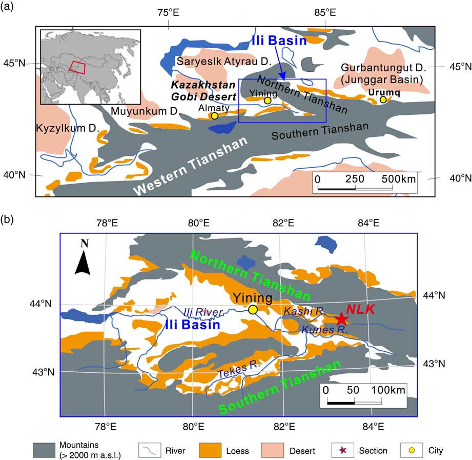
The Ili Basin is located in the eastern part of Central Asia, surrounded by the southern and northern branches of the Tianshan Mountain (Fig. 1). Dust accumulating in the basin is associated with the deceleration of upslope winds in encroaching westerly air masses. Thus, loess deposits have an extensive distribution in this basin, and studies of the loess deposits (Ili loess) can provide information about the paleoclimatic evolution of inland Asia. Recently, agreement has been reached regarding the reliability of geochronological ages of Ili loess dated with optically stimulated luminescence (OSL; Song et al., Reference Song, Li, Zhao, Cheng and Zeng2012, Reference Song, Lai, Li, Chen and Wang2015; Yang et al., Reference Yang, Forman, Song, Pierson, Mazzocco, Li, Shi and Fang2014; Kang et al., Reference Kang, Wang, Lu, Liu, Song and Wang2015). However, the results of previous studies based on a variety of paleoclimate proxies in the Ili Basin are inconsistent or even controversial. For example, magnetic susceptibility data derived from different loess-paleosol profiles do not display a positive relationship with pedogenesis intensity (Song et al., Reference Song, Nie, Shi, Wang, Qiang and Chang2010a, Reference Song, Shi, Fang, Nie, Naoto, Qiang and Wang2010b; Chen et al., Reference Chen, Liu, Heller, Hirt, Lu, Guo, Mao, Chen, Zhao and Feng2012; Jia et al., Reference Jia, Xia, Wang, Wei and Liu2012; Liu et al., Reference Liu, Shi, Deng, Su and Zhang2012). As a consequence, further study is needed to assess the paleoclimatic implications of the Ili loess.
(color online) Map showing (a) the studied area and (b) the location of the Nilka (NLK) section.

Clay minerals are mainly distributed in sedimentary rocks and Quaternary unconsolidated deposits. Singer (Reference Singer1980, Reference Singer1984) investigated the clay mineral assemblages in various sediments from different climate zones around the world, suggesting that there exist affinitive relationships between clay mineral assemblages, climate conditions, and weathering intensity in the source regions (Biscaye, Reference Biscaye1965; Thiry, Reference Thiry2000). The clay mineral assemblages have been studied widely in the loess deposits of the CLP (Zheng et al., Reference Zheng, Gu, Han and Deng1985; Bronger and Heinkele, Reference Bronger and Heinkele1989; Kalm et al., Reference Kalm, Rutter and Rokosh1996; Ji et al., Reference Ji, Chen and Lu1999; Zhao et al., Reference Zhao, Ji, Chen, Liu, Chen and Balsam2005; Gylesjo and Arnold, Reference Gylesjo and Arnold2006; Huang et al., Reference Huang, Zhao, Liu, Tan and Koopal2011), as have loess deposits in Central Asia (Pant and Dilli, Reference Pant and Dilli1986; Bronger et al., Reference Bronger, Winter and Sedov1998), Europe, and North America (Bronger, Reference Bronger1991; Bronger and Heinkele, Reference Bronger and Heinkele1990), in terms of their genesis as well as their tectonic and climatic significance. Clay minerals in the natural environment have various origins (Zhao and Zhang, Reference Zhao and Zhang1990), but cannot all serve as proxies for paleoclimate and weathering intensity. Therefore, it is necessary to evaluate the paleoclimatic significance of clay mineral records before paleoclimatic reconstruction can begin.
Although the sedimentology, geochemistry, and mineralogy of the Ili loess have previously been studied (Ye, Reference Ye2001; Zhang et al., Reference Zhang, Shi, Chen, Liu, Niu, Ming and Su2013; Song et al., Reference Song, Chen, Qian, Li, Li, Li, Chang and An2014; Li et al., Reference Li, Song, Lai, Han and An2016a; Li et al., Reference Li, Song, Chen, Li, Mamadjanov and Aminov2016b; Chen et al., Reference Chen, Song, Li, Fang, Li, Liu, Li and Orozbaev2017), clay mineralogy data have not yet been reported, and the suitability of the clay mineralogy for paleoclimatic reconstruction is still unclear. Therefore, the objectives of this paper are to: (1) present the composition of clay minerals in the loess-paleosol sequence at the Nilka (NLK) Section in the Ili Basin; (2) determine the genesis of these clay minerals; and (3) investigate their significance for weathering and paleoclimate interpretations.
PHYSICAL GEOGRAPHY AND THE NILKA SECTION
The Ili Basin (42°30ʹ-44°30ʹN, 80°-85°E) is a trumpet-shaped intermontane basin, narrowing eastward, surrounded by the Northern and Southern Tianshan Mountains to the north and south and with the Kazakhstan Gobi Desert situated to the west of the basin (Fig. 1). This region is characterized by a temperate and semi-arid continental climate, and precipitation and temperature are influenced by orographic effects (Ye, Reference Ye2001). The mean annual precipitation is between 200 and 500 mm on the plains, but can reach 1000 mm in mountainous areas (Hu, Reference Hu2004; Song et al., Reference Song, Chen, Qian, Li, Li, Li, Chang and An2014), while mean annual temperature ranges from 2.6 to 10.4°C. The zonal vegetation in this region is dominated by desert steppe and steppe and the soils are dominated by sierozems, castonozems and chernozems.
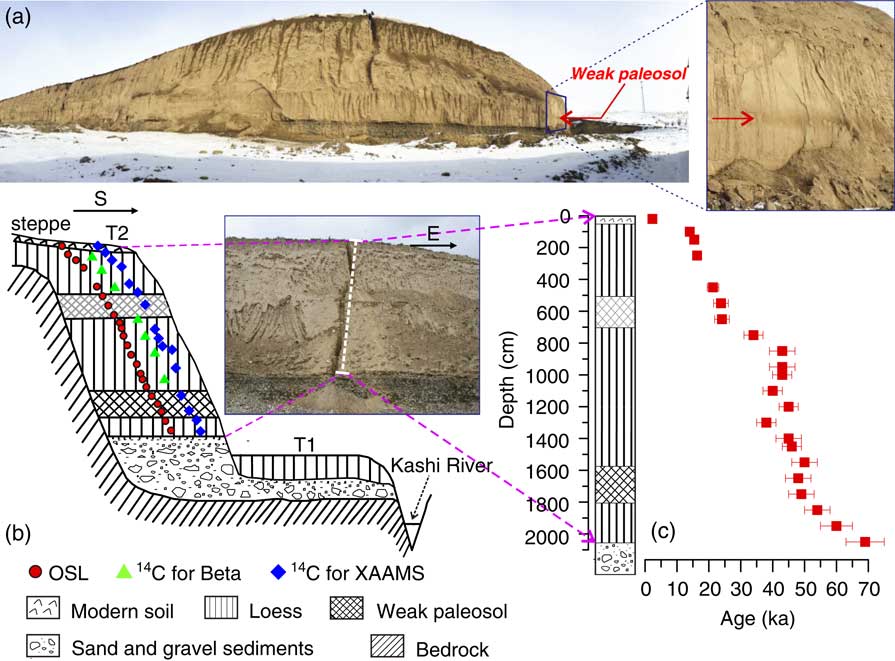
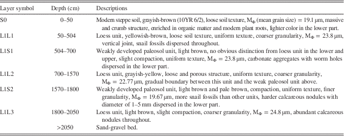
The Nilka (NLK) section (83.25°E, 43.76°N, 1253 m above sea level) has a loess thickness of 20.5 m and is located on the second terrace of the Kashi River valley, a branch of the Ili River in the eastern part of the Ili Basin (Fig. 2b). The loess section overlies fluvial sand and gravels and contains two thin paleosols (at depths of 504–700 cm and 1570−1800 cm; Fig. 2b–c, Table 1). The geochronology of the NLK section has been recently reported (Yang et al., Reference Yang, Forman, Song, Pierson, Mazzocco, Li, Shi and Fang2014; Song et al., Reference Song, Lai, Li, Chen and Wang2015), showing that the section spans nearly ~70 ka (Fig. 2c; Song et al., Reference Song, Lai, Li, Chen and Wang2015). We therefore divided the NLK stratigraphy into S0, L1L1, L1S1, L1L2, L1S2, and L1L3 units. The lithology of the section is described in Table 1.
(color online) (a) Panoramic photo of the NLK section. The second weakly developed paleosol can be observed visually (red arrow). (b) NLK section on the second terrace of Kashi River, looking north (samples for OSL and radiocarbon dating are also shown). (c) The depth-age relation in the NLK section (from Song et al., Reference Song, Lai, Li, Chen and Wang2015). (For interpretation of the references to color in this figure legend, the reader is referred to the web version of this article.).

Lithology of the Nilka (NLK) section

METHODS
Sampling
A total of 137 samples for clay mineral analysis were collected, at intervals of 20 cm and, in some cases, at intervals of 4–10 cm.
Clay minerals analysis
The clay mineral samples were extracted following the procedure described by Liu et al. (Reference Liu, Colin, Trentesaux and Blamart2005a), before X-ray diffraction (XRD) analysis. The procedure is summarized as follows: after removing organic matter and carbonates with 30% H2O2 and 10% HCl, respectively, deflocculation of clay was completed by repeated washing with deionized water; the <2 μm fraction was extracted from the suspension after a settling time calculated according to Stoke’s law, and then concentrated further by centrifugation. Finally, the paste was placed on a glass slide and dried overnight at room temperature. Three analysis conditions were used: (1) air drying, (2) ethylene glycol saturation at 60°C for 12 h, and (3) heating at 490°C for 2 h.
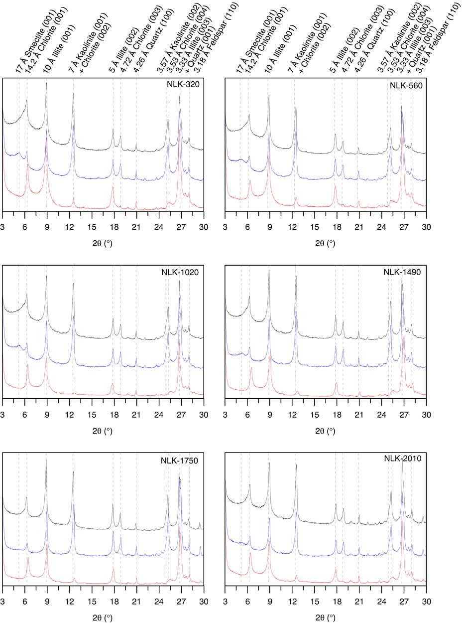
Qualitative and semi-quantitative estimations of clay-mineral assemblages were based on the position and intensity of peaks measured on X-ray diffraction patterns from oriented samples (Moore et al., Reference Moore, Distefano, Walsh, Schiering and Pai1989). The XRD patterns were obtained by a PANalytical X’Pert Pro MPD diffractometer with CuKα radiation and a Ni filter at a voltage of 40 kV and an intensity of 40 mA. Diffraction patterns were scanned from 3° to 30° 2θ, with a step size of 0.02°. Moreover, a slow scan, between 24° and 26° 2θ, with a step size of 0.005° 2θ, was performed on the glycolated samples to obtain a better resolution of the chlorite-kaolinite double peak. Identification of clay minerals was made mainly according to their basal reflections on the three X-ray diffraction spectra (Fig. 3). Semi-quantitative estimation was based on the peak areas of specific reflections measured in general in the EG runs (Zeng et al., Reference Zeng, Song, An, Chang and Li2014). Peak areas were calculated using the MacDiff 4.2.5 software (Petschick, Reference Petschick2000). The empirical factors of Biscaye (Reference Biscaye1965) were used during calculation of the proportions of each clay mineral. Finally, the relative abundances of each clay mineral were normalized to 100%.
(color online) X-ray diffraction (XRD) patterns (CuKα) of oriented clay samples from the NLK section. The sample NLK-1490 was collected from the depth of 1440 cm, NLK-1750 from 1700 cm, and NLK-2010 from 1960 cm. Three slides of each sample treated under air drying (black), ethylene glycol (EG) saturation at 60°C for 12 h (blue) and heating at 550°C for 2 h (red) were used to perform the qualitative estimations of clay-mineral assemblages. Semi-quantitative estimation is based on the peak areas of specific reflections measured in the EG runs. (For interpretation of the references to color in this figure legend, the reader is referred to the web version of this article.)

Scanning electron microscopy analysis
Micromorphologies of some selected clay mineral samples were observed with scanning electron microscopy (SEM). Clay samples were diluted with the anhydrous ethanol and dispersed ultrasonically. All samples were mounted on SEM stubs with conductive tapes and sputtered with gold before morphological observation. The SEM instrument (PhenomTMproX) is equipped with an energy dispersive spectrometer (EDS) system.
Grain size measurements
Grain size was measured for 0.5 g bulk samples using a Malvern Mastersizer 2000 laser particle size analyzer after pretreatment with the method described by Lu and An (Reference Lu and An1997). Carbonates and organic matter were removed with 15 mL of 10% HCl and 15 mL of 10% H2O2, respectively. Then deionized water was added and the sample suspension was left for 48 h prior to pipetting, to remove acidic ions. After that, the samples were dispersed with 10 mL of 30% (NaPO3)6 and placed in an ultrasonic vibrator for 10 min prior to the grain size measurements. Replicate analyses indicate that the MGS (mean grain size) has an analytical error of <2%. All analyses described above were carried out at the State Key Laboratory of Loess and Quaternary Geology, Institute of Earth Environment, Chinese Academy of Sciences.
RESULTS AND DISCUSSION
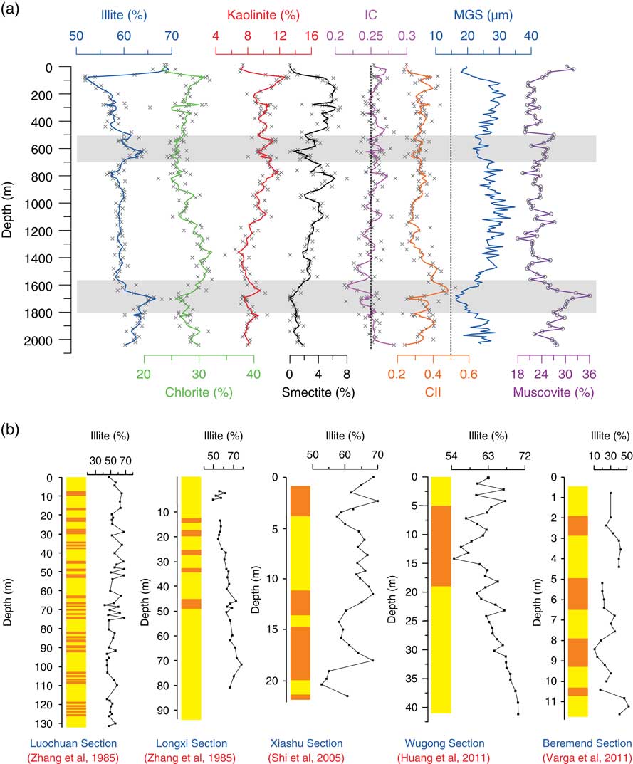
The major clay mineral components in the NLK section are illite, chlorite, kaolinite, and smectite (Fig. 3). Illite (average 60%) and chlorite (28%) are the dominant clay minerals in the NLK section (Fig. 4a), with minor kaolinite (9%) and smectite (3%). Clay minerals can be classified into four types according to their genesis: weathering, authigenic, diagenetic, and altered clay minerals (Chamley, Reference Chamley1981; Zhao and Zhang, Reference Zhao and Zhang1990). Many factors affect the clay mineral assemblages in sediments, such as the properties of parent rock, climate, topography, diagenesis and tectonics (Singer, Reference Singer1980, Reference Singer1984). Sun et al. (Reference Sun, Zhu and Bowler2004) suggested that the last main uplift of the Tianshan Mountain occurred in the early Pleistocene. Therefore, tectonic movement and topography have had only a minor impact on the composition of clay minerals in the NLK section since the last glacial period (Song et al., Reference Song, Lai, Li, Chen and Wang2015). After excluding the impact of diagenesis on clay mineral assemblages, we conclude that climate and/or provenance are the key factors controlling the variations of clay mineral composition in the NLK loess section.
(color online) (a) Mineralogy in weight percent of the main clay fraction from the NLK (Nilka) section vs. depth (3-point-running average). The IC (illite crystallinity), CII (chemical index of illite), MGS (mean grain size), and muscovite contents in bulk samples are also presented (for the relevant measurements of grain size and mineral composition of bulk samples, see the supplementary materials). The shaded area indicates the paleosol units. (b) Variations in illite contents along the different loess-paleosol sequences from the Chinese Loess Plateau (CLP; Zheng et al., Reference Zheng, Gu, Han and Deng1985; Huang et al., Reference Huang, Zhao, Liu, Tan and Koopal2011), the middle and lower reaches of the Yangtze River (Shi et al., Reference Shi, Zhang, Dai, Song, Yu and Zheng2005), and Hungary (Varga et al., Reference Varga, Újvári and Raucsik2011). The higher illite contents can be observed in the paleosol units than in the loess units at Luochuan, Longxi and Xiashu sections, while the opposite cases were presented at Wugong and Beremend sections.

The origin of illite and its effect on geochemical weathering indices
Illite, ranging from 52 to 71% and averaging 60%, dominates clay minerals throughout the NLK section (Fig. 4a). Higher illite contents were found in the two paleosol units compared to the loess units (Fig. 4a). This pattern is similar to that of the Luochun and Longxi sections in the CLP (Zheng et al., Reference Zheng, Gu, Han and Deng1985) and even the Xiashu loess, located in the middle and lower reaches of the Yangtze River (Shi et al., Reference Shi, Zhang, Dai, Song, Yu and Zheng2005), but inconsistent with the Wugong section located on the south of the CLP (Huang et al., Reference Huang, Zhao, Liu, Tan and Koopal2011) and in the Beremend Section, Hungary (Fig. 4b; Varga et al., Reference Varga, Újvári and Raucsik2011). The increase in illite content can be explained in two ways in the CLP: (1) finer eolian dust, carried by weaker winter monsoon winds, contains more illite (Ji et al., Reference Ji, Chen and Lu1999); and (2) detrital minerals in the loess have been transformed into illite by pedogenesis (Zheng et al., Reference Zheng, Gu, Han and Deng1985; Gylesjo and Arnold, Reference Gylesjo and Arnold2006).
Ji et al. (Reference Ji, Chen and Lu1999) summarized three major processes with respect to the illite formation in the weathering zone: (1) neoformation of illite from the weathering of feldspars; (2) illitization of smectite by repeated wetting and drying; and (3) physical and chemical weathering of muscovites to illite. Smectite contents in the NLK loess are too low to have produced significant illite. Illitization of smectite under wetting and drying alternation is always incomplete, and the transformation process can produce significant amounts of mixed-layer illite/smectite (I/S) (Rutter and Ding, Reference Rutter and Ding1993). No mixed layer I/S was identified in the XRD pattern, which excludes the second mechanism. Thus, we choose to focus on the other two processes as an explanation of the high illite contents in the paleosols.
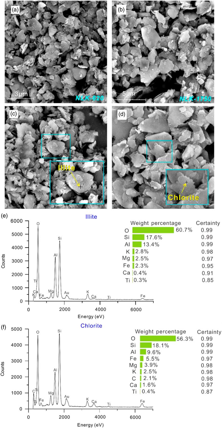
Illite can form during weathering of K-feldspars in continental deposits (Chamley, Reference Chamley1989; Thiry, Reference Thiry2000). However, the main feldspar mineral in the NLK loess is albite (Supplementary Note S1). No lath-shaped crystals were observed by SEM in the two paleosol units (Fig. 5a–b). Consequently, we conclude that the illite in NLK loess has not been produced by the weathering of feldspars. Although muscovite is easily abraded by physical weathering, muscovite is ground into clay-size grains only in the laboratory, not in nature (Srodon and Eberl, Reference Srodon and Eberl1984). Moreover, muscovite is so resistant to chemical weathering that Galovic (Reference Galovic2016) attempted to utilize it to study geological processes experienced by loess deposits in eastern Croatia, based on its edge and surface micro-textures. That, combined with the biotite-like nature of illite in NLK loess (see the following), suggests that illite here has not originated from the weathering of muscovite.
(color online) The scanning electron microscopy (SEM) observations of clay minerals. The photographs (a) and (b) were taken from weak paleosol layers. The rounded outlines (c) of clay minerals suggested a dominantly physical weathering environment and the embayed edges (d) showed intensive dissolution during weathering. The energy dispersive spectrometer (EDS) spectra are also presented to identify clay minerals (e and f).

Therefore, we suggest that the illite in the paleosols has a detrital, not a pedogenic, origin, most likely provided by physical weathering of rocks rich in biotite (similarly to that which the chemical index of illite has exhibited), such as gneisses, granites, and granitoids. Using the geological map of Ren et al. (Reference Ren, Niu, Wang, He, Jin, Xie and Zhao2013; IGMA5000) and a previous report on the lithology of Kyrgyz West Tianshan (Rolland et al., Reference Rolland, Alexeiev, Kröner, Corsini, Loury and Monié2013; Orozbaev et al., Reference Orozbaev, Hirajima, Bakirov, Takasu, Maki, Yoshida and Sakiev2015), it is clear that there are some Ordovician, Silurian, and Devonian granites and small amounts of Permian gneisses in the western parts of the Ili Basin. The illite directly eroded from these bedrock areas by physical weathering may have been transported by fluvial processes to the loess source areas (Gallet et al., Reference Gallet, Jahn, Lanoe, Dia and Rossello1998). Subsequently, it may have been deflated and entrained by wind and transported to the NLK site, giving rise to the broken and rounded outline observed on many of the illite particles (Fig. 5c).
Generally, illite is preserved well in cold and dry environments, and its crystallinity decreases because of hydrolysis and leaching processes in warm and humid environments (mean annual precipitation of 500–1000 mm). The expansible layers become more prevalent in the crystal structure of illite and even lead to the transformation into the expandable 2:1 layer minerals vermiculite or smectite (Chamley, Reference Chamley1989). However, a map of 500–1000 mm isohyets identifies areas having a corresponding sub-humid and humid climate, revealing that such high precipitation levels rarely occur at low altitudes in central Asia. Even in the CLP, illite is not easily weathered in the warm and wet conditions of the East Asian Monsoon (Zhao et al., Reference Zhao, Ji, Chen, Liu, Chen and Balsam2005). Therefore, we conclude that the crystal structure of illite in NLK loess has not changed due to weathering.
Illite crystallinity (IC) and the chemical index of illite (CII) may be more sensitive climate metrics than the absolute amounts of illite because IC and CII are less influenced by sediment dynamic differentiation (Wang and Yang, Reference Wang and Yang2013). The IC value of illite was determined by measuring the half-peak width of the 10 Å peak, and expressed in °Δ2θ (Pandarinath et al., Reference Pandarinath, Prasad and Gupta1999; Ji and Browne, Reference Ji and Browne2000; Ehrmann et al., Reference Ehrmann, Setti and Marinoni2005). High values indicate lower crystallinities, whereas low IC values indicate strong crystallinities. The CII refers to the ratio of the 5 Å and 10 Å peak areas. In this study, the IC values ranged from 0.213 to 0.296, with an average of 0.252; CII values varied from 0.227 to 0.523, with an average of 0.332, suggesting that the illite in the NLK loess has high crystallinity and a more biotite-like structure (Diekmann and Wopfner, Reference Diekmann and Wopfner1996; Ehrmann et al., Reference Ehrmann, Setti and Marinoni2005). Therefore, these data indicate little to no modifications of illite in this section.
In general, both IC and CII decrease in dry and cold climates, where the hydrolysis reaction is slow, but attains higher values in humid and warm climates, where hydrolysis can be rapid (Chamley, Reference Chamley1989; Pandarinath, Reference Pandarinath2009). However, the IC and CII profiles of the NLK section display opposite trends (Fig. 4a), especially at depths of 1200–1800 cm (about 40–50 ka, see Fig. 2c). Kübler (Reference Kübler1967) defined 0.42 and 0.25 as the respective upper and lower bounds of an anchimetamorphic zone or “anchizone.” Therefore, we ascribe the opposing trends in the IC and CII profiles to changes in lithology of the Tianshan bedrock. These bedrock units provide sediments for the potential source areas of NLK loess at ca. 40–50 ka, while tectonic movement may be responsible for the lithological changes (e.g. Yang et al., Reference Yang, Li and Hunag2013); however, the potential source areas show limited changes, because the mean grain size (MGS), i.e., wind strength (see below), does not appear to affect variations in IC and CII values.
The MGS is regarded as an indicator of wind intensity in the CLP (Sun et al., Reference Sun, Wang, Liu and Clemens2010) because stronger winds can transport coarser particles. The grain size distribution in the loess/palaeosol sequence of Wels-Aschet in Upper Austria is also related to the degree of weathering, with pedogenesis decreasing the MGS in the loess (Terhorst et al., Reference Terhorst, Ottner and Wriessnig2012). Quartz grains are more resistant to weathering and remain largely unaltered during post-depositional processes, so their grain size is considered as a more reliable indicator of wind strength (Xiao et al., Reference Xiao, Porter, An, Kumai and Yoshikawa1995). Supplementary Figure 1a shows the grain size distributions of quartz grains isolated from loess (yellow) and paleosol (red) samples. The quartz modal grain size is finer in the paleosol unit than in the primary loess unit. From this we can deduce that wind strength was weaker during periods of pedogenesis, and stronger during periods of loess deposition. The grain size distributions of bulk samples display similar characteristics to those of quartz samples mentioned above (Supplementary Fig. 1b), whereby soil unit modal peaks (red and orange) are smaller than those of primary loess (blue and green). Therefore, we argue that wind strength, rather than post-depositional pedogenesis, has the greatest influence on grain size distribution at NLK. In addition, distance from the loess section to the source area also influences grain size distribution (Ding et al., Reference Ding, Sun, Rutter, Rokosh and Liu1999a, Reference Ding, Derbyshire, Yang, Sun and Liu2005; Yang and Ding, Reference Yang and Ding2008). However, this factor mainly influences the sand content (>63 µm) of loess deposits in loess-desert transition zones (e.g., the northern part of the CLP; Ding et al., Reference Ding, Sun, Rutter, Rokosh and Liu1999a). The NLK is >400 km from the deserts to the west of the Ili Basin (Fig. 1a), and, considering the unmixed end-member of loess grain-size distributions, we found that the fine sand end member is absent in the NLK loess (Li et al., Reference Li, Song, Fitzsimmons, Chang, Orozbaev and Li2017). This suggests that sand fraction may not have had significant impact on the grain size distribution patterns of the NLK loess. Therefore, the influence of distance from the loess profile site to the source area(s) on grain size in NLK loess can be neglected, also implying that MGS is an indicator of wind intensity at the NLK site.
Illite in the NLK section originated directly from physical weathering of parent rocks, and maintained its original structure during transportation and deposition processes. In addition, the MGS variations indicate that wind intensity decreased when weak paleosols developed. Thus, the fine fractions, such as clay minerals, were predominantly transported to the sections, not weathered in-situ, and the enrichment of illite in paleosol units compared to that in loess units was mainly caused by the weaker wind intensity rather than pedogenesis. This interpretation is also supported by a wind tunnel experiment (Wang et al., Reference Wang, Lang, Hua, Zhang and Li2017). The experimental results suggested that there is an inverse correlation between wind velocity and the content of fine fractions with a diameter of <2.5 µm (cf. fig.5 in Wang et al., Reference Wang, Lang, Hua, Zhang and Li2017).
Muscovite contents in bulk samples (Supplementary Note S1) are negatively correlated with MGS (Fig. 4a). Muscovite has a flakey form, implying that it can be readily transported by wind and is not easily deposited even under light winds. This would lead to the sorting of minerals with different crystal morphologies, especially when winds weakened, resulting in the differences in muscovite content between loess and paleosol units (Fig. 4a).
Idealized muscovite gives a chemical index of alteration (CIA) value of 75, and the CIA value of illite ranges between 75 and 85 (Nesbitt and Young, Reference Nesbitt and Young1982). We argue that wind transported more illite and muscovite to the NLK site during the development of the paleosol units, which increased the CIA values of the paleosols. That also indicates the influence of grain size sorting on the major and trace elements contents in loess deposits (Gallet et al., Reference Gallet, Jahn and Torii1996; Bauluz et al., Reference Bauluz, Mayayo, Fernandez-Nieto and Lopez2000; Xiong et al., Reference Xiong, Zhu, Zhou, Lu and Ding2008; Liang et al., Reference Liang, Sun, Beets, Prins, Wu and Vandenberghe2013; Ben Israel et al., Reference Ben Israel, Enzel, Amit and Erel2015; Li et al., Reference Li, Song, Chen, Li, Mamadjanov and Aminov2016b). Therefore, the CIA values of paleosol units in loess sections may be overestimated, especially for those sections in which the paleosols have higher illite contents than the loess. Moreover, illite is enriched in Al when compared to plagioclase (Nesbitt and Young, Reference Nesbitt and Young1982; Mclennan, Reference Mclennan1993). Thus, particular attention must also be paid to the use of Chemical Proxy of Alteration (CPA) to indicate the degree of silicate weathering (Buggle et al., Reference Buggle, Glaser, Hambach, Gerasimenko and Markovic2011).
The origin of chlorite and kaolinite and their abilities to reconstruct paleoclimate
Chlorite accounts for 21−35% of the clay fraction in loess at the NLK section, with an average of 28%, while kaolinite accounted for relatively smaller proportions, with an average of 9% (Fig. 4a). The variations in chlorite and kaolinite contents are independent of loess lithology (Fig. 4a). Kaolinite can form rapidly under a strong chemical weathering regime and its abundance may be an indicator of subtropical to tropical climates (Chamley, Reference Chamley1989; Ruffell et al., Reference Ruffell, McKinley and Worden2002). Given the location of the NLK section in the interior of Eurasia, it can be inferred that the kaolinite in the NLK loess was derived from physical weathering of kaolinite-bearing sedimentary rocks in Tianshan, instead of a weathering product in the source area or in the loess section itself. The occurrence of kaolinite here might not represent wet and warm conditions.
Trioctahedral Fe/Mg-rich clay minerals, e.g., chlorite, are sensitive to chemical weathering, while dioctahedral Al-rich clay minerals such as kaolinite are difficult to weather. Chlorite is the second-most abundant clay component in the section and indicates weak weathering (Chamley, Reference Chamley1998; Terhorst et al., Reference Terhorst, Ottner and Wriessnig2012) in the NLK loess. Chlorite is a common mineral in metamorphic rocks undergoing green schist facies metamorphism and it also exists in sedimentary rocks. Chlorite is the direct product of parent rocks which have undergone little chemical weathering (Robert and Kennett, Reference Robert and Kennett1994); it is not formed pedogenically in the loess sequence.
Kaolinite and chlorite contents have negative relationships in the NLK loess (Fig. 4a). The appearance and preservation of detrital chlorite is connected to the physical weathering of rocks under cold and dry climates (Ehrmann and Mackensen, Reference Ehrmann and Mackensen1992; Ehrmann et al., Reference Ehrmann, Melles, Kuhn and Grobe1992). In contrast, the presence of detrital kaolinite is mainly connected to the chemical weathering of soils in warm and wet climates (Robert and Kennett, Reference Robert and Kennett1994). Therefore, the incompatibility of chlorite and kaolinite is as expected and it seems that both could have been inherited from the same parent rocks, most likely sedimentary rocks. However, the correlation coefficient (R2; depth >200 cm) is 0.31. The low R2 value may imply that there are additional sources of chlorite, e.g., metamorphic, but not sedimentary, rocks. Moreover, notably, chlorite contents decrease in the middle of the second paleosol unit, perhaps resulting from either relatively stronger weathering or greater dilution by illite (Fig. 4a and 5d).
The detrital clay minerals in sedimentary rocks from some basins can be used to reliably reflect the paleoenvironmental or tectonic conditions (Liu et al., Reference Liu, Colin, Trentesaux, Siani, Frank, Blamart and Farid2005b; Berrocoso et al., Reference Berrocoso, Zuluaga and Elorza2008; Hong et al., Reference Hong, Zhang and Li2010; Riboulleau et al., Reference Riboulleau, Bout-Roumazeilles and Tribovillard2014). However, loess deposits, as eolian sediments, have more complicated sources. They have experienced at least one cycle of transportation to a source area (Gallet et al., Reference Gallet, Jahn, Lanoe, Dia and Rossello1998) and have been well mixed during transportation by wind. Therefore, the paleoclimatic signals in the detrital clay source minerals in loess deposits can be obscured. Both chlorite and kaolinite in NLK loess were inherited from the bedrock in the Tianshan area, mainly by physical erosion, and mixed during eolian transport. Therefore, it is difficult to extract information about paleoclimate in the provenance region or depositional area. However, the presence of abundant chlorites indicates weak weathering within the NLK loess.
The origin of smectite and its paleoclimate implication
The NLK section contains only a small amount of smectite (possibly including mixed illite-smectite species). The smectite contents in the loess are higher than those in paleosols such as the Wugong section (Huang et al., Reference Huang, Zhao, Liu, Tan and Koopal2011). Volcanic materials can easily be transformed into smectite during early diagenesis or by hydrothermal and chemical weathering processes (Chamley, Reference Chamley1989; Cuadros et al., Reference Cuadros, Caballero, Huertas, De Cisneros, Huertas and Linares1999); and, even in marine sediments, authigenic smectites also can be generated through submarine weathering of basaltic or pyroclastic materials (Biscaye, Reference Biscaye1965; Petschick et al., Reference Petschick, Kuhn and Gingele1996; Ehrmann, Reference Ehrmann1998). However, the volcanogenic smectites are almost always associated with tuff layers in sedimentary sequences (Deconinck et al., Reference Deconinck, Amedro, Baudin, Godet, Pellenard, Robaszynski and Zimmerlin2005; Do Campo et al., Reference Do Campo, del Papa, Nieto, Hongn and Petrinovic2010). No volcanic ash layer was observed in the NLK section: thus, smectite in the NLK loess is unlikely to have this origin. Variations in smectite contents do not correlate with those of kaolinite and chlorite, indicating that the smectite had different origins. Therefore, it can be expected that smectite in NLK loess formed by transformation or neoformation in the source or deposit areas during a weathering process.
Dioctahedral smectite can form as the first weathering product of plagioclase, while trioctahedral smectite generally forms during the weathering of biotites (Pal and Deshpande, Reference Pal and Deshpande1987; Srivastava et al., Reference Srivastava, Parkash and Pal1998). To estimate the crystal structure of smectite, eleven samples were selected from the loess and paleosols to analyze the position (angle) of the (060) diffraction peak. Strong 060 reflection at 1.54 Å indicates that these are trioctahedral smectites in all the selected samples (Supplementary Fig. 2). Furthermore, some of the illite has a biotite-like nature, according to the CII values. Therefore, smectite in the NLK loess probably formed by weathering of biotite or transformation of illite with removal of interlayer K.
Increasing available moisture in soil promotes leaching and, consequently, the release of K from micaceous minerals (Khormali and Kehl, Reference Khormali and Kehl2011). A calcareous environment with high Mg2+ and high Si4+ mobility may provide favorable conditions for the formation of smectite through transformation. The formation of smectite can hence reflect paleohydrology (Chamley, Reference Chamley1989). However, temporal changes in smectite content resemble those of MGS in NLK section (Fig. 4a). MGS can reflect the wind intensity, with weaker winds possibly leading to the relatively low contents of smectite. This characteristic may reflect the tendency of finer particles in loess to become aggregated (Pye, Reference Pye1995; Mason et al., Reference Mason, Jacobs, Greene and Nettleton2003; Qiang et al., Reference Qiang, Lang and Wang2010; Mason et al., Reference Mason, Greene and Joeckel2011; Újvári et al., Reference Újvári, Kok, Varga and Kovács2016), especially for the clay-sized minerals, by electrostatic forces, salts, or organic matter (Pye, Reference Pye1995). This view is also supported by the observations of bulk samples (Fig. S3). Smectite tends to form aggregates during transport due to its high hygroscopic capacity (Singer et al., Reference Singer, Dultz and Argaman2004). The stronger winds can carry larger aggregates, and thus more smectite, to the loess depositional areas. Therefore, smectite was most likely formed in the source area, then transported to the NLK site. Its presence may not indicate moisture conditions, due to the impact of wind intensity. Although the influence of larger calculation errors on the variations in smectite content cannot be excluded, more research on the effect of climate vs. weathering on smectite contents in loess deposits is needed.
The suitability of clay minerals as tracers of dust provenance
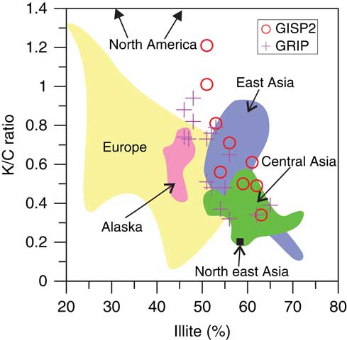
In light of the genesis of clay minerals in NLK loess, we believe that clay mineralogy is a potentially useful tracer of dust provenance. The significance of aeolian dust lies in its ability to reconstruct large-scale atmospheric circulations. Dust in ice cores so far has been studied by many researchers (e.g., Kohfeld and Harrison, Reference Kohfeld and Harrison2001, and references therein). Discrimination of potential source region(s) would enable a better understanding of past dust transport paths, assisting the development of model simulations of past atmospheric circulation patterns. The approach of tracing source region(s) involved comparing the specific “fingerprints,” such as mineralogy, chemistry, and isotopes, of potential source areas and dust in the ice cores (Fuhrer et al., Reference Fuhrer, Neftel, Anklin, Staffelbach and Legrand1996; Biscaye et al., Reference Biscaye, Grousset, Revel, VanderGaast, Zielinski, Vaars and Kukla1997; Maggi, Reference Maggi1997; Steffensen, Reference Steffensen1997). Central Asia is also one of the major dust source areas (Muhs, Reference Muhs2013), and the present-day dust flux there accounts for 7.5% of the annual mean global emission flux (Tanaka and Chiba, Reference Tanaka and Chiba2006), or even 16% according to Miller et al. (Reference Miller, Tegen and Perlwitz2004). However, it has not been considered as a potential source region, maybe due to a lack of the data that can serve as the “fingerprint” (Biscaye et al., Reference Biscaye, Grousset, Revel, VanderGaast, Zielinski, Vaars and Kukla1997; Svensson et al., Reference Svensson, Biscaye and Grousset2000; Újvári et al., Reference Újvári, Stevens, Svensson, Klötzli, Manning, Németh and Kovács2015). Here, we presented clay mineralogical compositions of NLK loess in Central Asia, which supplement data on the potential source regions. The kaolinite to chlorite (K/C) ratio is usually a diagnostic employed for the discrimination of source areas (Biscaye et al., Reference Biscaye, Grousset, Revel, VanderGaast, Zielinski, Vaars and Kukla1997; Újvári et al., Reference Újvári, Stevens, Svensson, Klötzli, Manning, Németh and Kovács2015), based on its latitude dependency (Biscaye, Reference Biscaye1965; Griffin et al., Reference Griffin, Windom and Goldberg1968; Scheuvens et al., Reference Scheuvens, Schutz, Kandler, Ebert and Weinbruch2013) and the local lithology and climate and drainage characteristics. Because of the complex behaviors of smectite during emission, transport and deposition, we used a K/C ratio to illite content plot (Újvári et al., Reference Újvári, Stevens, Svensson, Klötzli, Manning, Németh and Kovács2015) to discriminate and identify the source areas from which the dust in Greenland ice cores originated (Fig. 6). These potential source areas can be separated from each other to a large extent. Data points of Greenland ice cores (Biscaye et al., Reference Biscaye, Grousset, Revel, VanderGaast, Zielinski, Vaars and Kukla1997; Svensson et al., Reference Svensson, Biscaye and Grousset2000) are mainly located in the East Asian and central Asias areas, implying that the extensive arid or semi-arid hinterlands of Asia are important dust sources for Greenland ice cores.
(color online) Kaolinite/chlorite (K/C) versus illite contents of Greenland last glacial maximum (LGM) dust and samples. The distribution ranges of the potential source areas in this figure are confined based on the data of loess from East Asia (11 samples); Central Asia (this study, 137 samples); Northeast Asia (1 samples); Alaska (8 samples); and Europe (10 samples). Data from: Biscaye et al., Reference Biscaye, Grousset, Revel, VanderGaast, Zielinski, Vaars and Kukla1997; Svensson et al., Reference Svensson, Biscaye and Grousset2000; Ujvari et al., 2015.

CONCLUSIONS
Clay mineralogy of a late Pleistocene loess-paleosol sequence named the NLK loess section in the Ili basin indicated that the clay minerals are mainly composed of illite, chlorite, kaolinite, and smectite. Illite dominates the clay fraction components, followed by chlorite, while kaolinite and smectite are present at relatively lower contents.
Illite has a detrital origin and we did not find that obvious modifications to illite had occurred during transportation and deposition. The higher content of illite in paleosols vs. loess units is probably ascribed to the weaker wind intensity, which, combined with data for muscovite, supported the influence of grain size sorting on CIA and CPA values. That leads to an overestimation of the weathering intensity of paleosol units. Chlorite and kaolinite in NLK loess were likely to have been directly inherited from the parent rocks in the Tianshan Mountains. Although it was difficult to extract information on paleoclimate in the provenance or depositional areas from either type, the presence of abundant chlorites would indicate weak weathering in the NLK loess. Smectite was more likely formed by the transformation of biotite and illite in the source area; however, its role as an indicator of environmental conditions might also be limited due to its complex behaviors during emission, transport, and deposition. In spite of the possible liminations of clay minerals in interpreting paleoclimate evolution, they can be regarded as a tool for tracing the dust provenance.
ACKNOWLEDGMENTS
We sincerely appreciate the scientific comments and suggestions from Randall Schaetzl, Steven L. Forman, Nicholas Lancaster, Yunfa Miao, Jianyong Li, and anonymous reviewers that improved this manuscript greatly. We also thank Yun Li, Xinxin Li, and Junchao Dong for sampling and laboratory assistance. The project is supported by the National Key Research and Development Program of China (grant numbers: 2016YFA0601902, 2013CB955904); Natural Science Foundation of China (grant numbers: 41572162, 41290253); and the International partnership Program of Chinese Academy of Science (grant number: 132B61KYS20160002).
Supplementary material
To view supplementary material for this article, please visit https://doi.org/10.1017/qua.2017.58