Introduction
The consequences of twenty-first century climate change, including rising sea levels, rapid erosion and increased storm intensity, pose significant risks to coastal archaeological sites. The scale of this challenge is made evident in recent regional studies, which collectively demonstrate that this issue is pervasive and global (e.g. Erlandson Reference Erlandson2008; Reeder-Myers Reference Reeder-Myers2015; Anderson et al. Reference Anderson, Bissett, Yerka, Wells, Kansa, Kansa, Myers, DeMuth and White2017; Hambrecht & Rockman Reference Hambrecht and Rockman2017; Hollesen et al. Reference Hollesen, Callanan, Dawson, Fenger-Nielsen, Friesen, Jensen, Markham, Martens, Pitulko and Rockman2018; McCoy Reference McCoy2018). Although archaeologists have proposed and implemented many techniques for evaluating the extent of archaeological site vulnerability, we struggle to find the funding, time and labour to implement mitigation strategies. Several studies have proposed a citizen science approach to archaeological site monitoring (e.g. Haugen & Mattsson Reference Haugen and Mattsson2011; Dawson Reference Dawson, Daire, Dupont, Baudry, Billard, Large, Lespez, Normand and Scarre2013; Daly Reference Daly2014; Carmichael et al. Reference Carmichael, Wilson, Namarnyilk, Nadji, Brockwell, Webb, Hunter and Bird2017). This, however, might not be feasible in some regions, due either to remoteness or to regulations controlling access to archaeological site information.
Here, we present an innovative method for rapidly assessing vulnerable shorelines and efficiently collecting information in threatened coastal areas, using kayaks to move quickly along the coast when tides are low and vegetation sparse. Alongside this survey work, we have also implemented a systematic radiocarbon dating programme to collect important information about ancient land use in erosional environments (Erlandson & Moss Reference Erlandson and Moss1999). This method provides an effective tool for mitigating the effects of erosion and sea-level rise by collecting data from the most vulnerable sites—those immediately adjacent to coastlines. Sites that are currently in or just above the intertidal zone will probably become inaccessible in the coming decades; but as our case study demonstrates, such sites may be important for clarifying the answers to important questions about gaps in local settlement chronologies, for example.
Background and methods
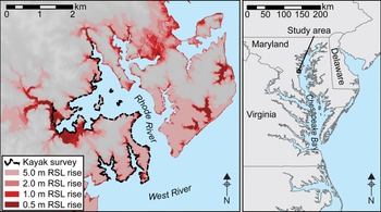
A number of archaeological survey and excavation projects have focused on the shell middens and other coastal sites in the vicinity of the Rhode River estuary in Chesapeake Bay (Figure 1) (Wright Reference Wright1969, Reference Wright1973; Gibb & Hines Reference Gibb and Hines1997; Cox Reference Cox2007a & Reference Coxb; Rick et al. Reference Rick, Reeder-Myers, Cox, Sperling, Jansen and Hines2014, Reference Rick, Reeder-Myers, Carr and Hines2017). Systematic radiocarbon dating has identified possible gaps in the local occupation record, with no known shell middens dated to transitional periods, such as between the Early and Middle Woodland, the Middle and Late Woodland and the Late Woodland and Historic periods (Rick et al. Reference Rick, Reeder-Myers, Cox, Sperling, Jansen and Hines2014). Another recent study has evaluated the status of archaeological sites within the context of coastal erosion and sea-level rise, and found that shell middens are especially at risk (Anne Arundel County Office of Planning and Zoning 2010). This suggests that there may be a relatively narrow window of opportunity for documenting settlement patterns and establishing chronologies here and elsewhere on Chesapeake Bay.
Map of the Rhode River area, showing the location of the kayak survey and the extent of inundation that may occur with future sea-level rise, using one-ninth arc-second elevation data from the USGS National Elevation Dataset (figure by L. Reeder-Myers).

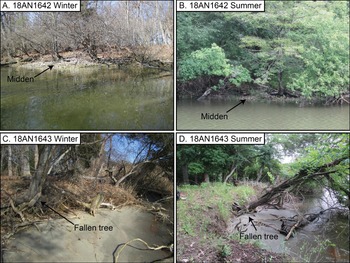
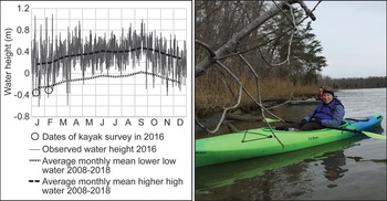
The aim of our study was to test whether kayak survey during winter—when tides are lowest and dense vegetation is reduced (Figure 2)—would be an effective method for locating sites near or below the waterline during summer tides (Lowery Reference Lowery2005). Such sites are particularly vulnerable to shoreline erosion, and are also more likely to have been overlooked during earlier surveys. We anticipated that intertidal survey would reveal more Early (1300–500 BC) and Middle (500 BC–AD 900) Woodland sites. These would have been occupied when relative sea level was several metres lower, perhaps explaining why they are currently scarce in the Rhode River estuary (Engelhart et al. Reference Engelhart, Peltier and Horton2011; Rick et al. Reference Rick, Reeder-Myers, Cox, Sperling, Jansen and Hines2014). Due to the long, narrow shape of the estuary, the prevailing winds and atmospheric pressure systems have a substantial effect on sub-tidal sea level in Chesapeake Bay. In the upper part of the bay, north-westerly and north-easterly winter winds combine with a north-west to south-east winter pressure gradient to push water towards the mouth of the bay (Salas-Monreal & Valle-Levinson Reference Salas-Monreal and Valle-Levinson2008). While this pattern is common to estuaries across the world, it is unusually strong in Chesapeake Bay. Here, variability in sub-tidal sea level means that winter neap tides are commonly 0.3m lower than summer neap tides (Figure 3), although extreme weather conditions can create situations where the difference is 1m or more.
Examples of change at archaeological sites between January 2016 and June 2018. A–B) at 18AN1642, with each photograph taken near low tide. Summer vegetation and the higher water level obscured a large historic midden that was easily visible during the winter; C–D) at 18AN1643, the shoreline eroded enough during these two years for a tree to fall (figure by L. Reeder-Myers).

Observed tides (left) for 2016 at Annapolis, Maryland, just north of the study area, along with average monthly lower low water mean and higher high water mean, from 2008–2018. Circles represent the timing of the kayak survey (right; photograph by T. Rick). Tide data were obtained from the U.S. National Oceanic and Atmospheric Administration, Center for Operational Oceanographic Products and Services (figure by L. Reeder-Myers).

In January and February 2016, groups of one to three kayakers spent four days surveying the coastline of the Rhode River and adjacent areas that were within the property of the Smithsonian Environmental Research Center (SERC; Figure 1). We chose days when tides were particularly low (Figure 3), and worked in groups to move as close to the shoreline as possible, searching for evidence of past human activity, such as oyster (Crassostrea virginica) or other shells, vertebrate faunal remains, conspicuously dark soil, lithics, ceramics and historical debris. We subsequently made two further visits by land, to confirm details of our original findings and to survey areas that could not be reached by kayak. We also attempted to rediscover previously recorded sites—especially those that we had not been able to access and/or locate by land, and those that were thought to have been destroyed by erosion. Each site identified was described, documented with photographs and GPS location data recorded. Individual oyster shells from deposits exposed in the bank at the water's edge were collected for radiocarbon dating. Samples were taken from undisturbed deposits, avoiding contexts that were highly fragmented, eroded or in the plough zone. Shells were sampled from the top and bottom of thicker deposits, but most deposits were very thin, allowing for the collection of only a single shell. Where a site extended over a large area, we collected shells from multiple locations.
Although the unusual working conditions presented some challenges, we were fortunate to encounter sunny, calm weather for most of the survey period. Waterproof bags kept recording materials dry. Members of the research team wore chest waders, warm clothing and lifejackets. At many sites, we were able to get out of the kayaks to make observations and collect shells, only occasionally needing to operate solely from the kayak.
Oyster shells were sent for AMS dating to the University of Georgia Center for Applied Isotope Studies (see Table S1 in the online supplementary material (OSM)). Dates were calibrated using OxCal 4.3 using the Marine13 curve and a marine reservoir correction of ∆R = 97±18 (Bronk Ramsey Reference Bronk Ramsey2009; Reimer et al. Reference Reimer2013; Rick et al. Reference Rick, Reeder-Myers, Cox, Sperling, Jansen and Hines2014). Using OxCal 4.3's Bayesian platform, we modelled all of the new and previously reported dates. Bayesian statistics provide an important tool for modelling site chronologies (Hamilton & Krus Reference Hamilton and Krus2018). Given that our dates derive from the entire watershed, we grouped all of them into a phase model with three sequences separated by two gaps in the calibrated age ranges (see Table S2). All of the dates were ordered chronologically by their calibrated age, providing a model for the duration of the SERC shell middens that can guide future, more detailed Bayesian modelling.
Results and discussion
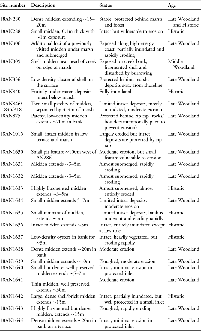
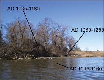
The kayak survey covered 23.3km of shoreline in four days of fieldwork. We identified 15 new archaeological sites and rediscovered eight sites that we had not been able to identify during earlier terrestrial visits (Table 1 & Figure 4). New deposits were identified at site 18AN306, although we had previously visited and radiocarbon dated the landward portion of the site (Figure 5). We were unable to relocate eight previously recorded sites (18AN281, -298, -303, -305, -307, -842, -849 and -864), and assume that they have been lost to coastal erosion (Figure 4). All of the sites identified were shell middens. Thirty-three new radiocarbon dates were obtained from these sites (see Table S1), bringing the total number to 88 radiocarbon dates from 50 shell middens within SERC property and the immediate area. This provides a comprehensive view of the chronology of past estuary-resource use in this area (Figure 6).
Site descriptions and status updates for relocated and new sites in the study area.

Distribution of previously recorded and new shell midden sites on the Smithsonian Environmental Research Center property and in the immediate vicinity (figure by L. Reeder-Myers).

Deposits from 18AN306 are distributed on a ~4m-high terrace, below an adjacent marsh and in the riverbed. Overlapping dates from these three locations suggest a complex occupational and post-depositional history for this site, which may once have been very extensive (figure by L. Reeder-Myers).

Bayesian model of radiocarbon-dated components from the Smithsonian Environmental Research Center property and immediate vicinity. The right side of the figure is a continuation of the left. Dates were calibrated using OxCal 4.3, the Marine13 curve and a marine reservoir correction of ΔR = 97±18 (Bronk Ramsey Reference Bronk Ramsey2009; Reimer et al. Reference Reimer2013; Rick et al. Reference Rick, Reeder-Myers, Cox, Sperling, Jansen and Hines2014). Each sample is labelled with the site number (e.g. site 18AN312 is labelled with ‘312’), the laboratory number and the agreement index (A:#). Samples marked with * are new to this study; others were reported by Rick et al. (Reference Rick, Reeder-Myers, Cox, Sperling, Jansen and Hines2014) (figure by L. Reeder-Myers & T. Rick). For more information about the radiocarbon dates and the Bayesian phase model depicted here, see the OSM.

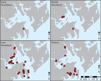
Previous radiocarbon dating has identified a small number of chronological gaps for shell middens, including a break between the Early and Middle Woodland and shorter gaps between the Middle and Late Woodland, and between the Late Woodland and early Historic periods (Rick et al. Reference Rick, Reeder-Myers, Cox, Sperling, Jansen and Hines2014). Bayesian modelling of all of the shell middens in the SERC vicinity produced a valid model with agreement indices above 60 for all dates and the overall model (Amodel = 69.5; Figure 6; see Table S2). The previous gap between the Late Woodland (AD 900–1600) occupation at 18AN294 (AD 1450–1590) and the Historic occupation at 18AN304 (AD 1540–1820) is now closed by four sites in Cheston Creek and one site in Boathouse Creek (Figure 7). This suggests that there was little, if any, cessation in the human harvesting of oysters after the arrival of Europeans. As this was a rapid survey, we were generally unable to observe artefacts at these sites. It is therefore challenging to determine whether they were used by people of indigenous, African or European descent. The many diverse peoples living around Chesapeake Bay during the Historic periods (AD 1600–1900) probably all relied on oysters to some extent, although this hypothesis requires further exploration.
Distribution of sites in the study area throughout the Woodland and Historic periods (figure by L. Reeder-Myers).

The newly modelled sequence also reduces, but does not remove, the gap between the Middle (sequence 2) and Late (sequence 3) Woodland, which is now only around 50 years (Figure 6). An approximately 600-year occupation gap also still appears between the modelled Early (sequence 1) and Middle (sequence 2) Woodland chronology (Figure 6 & Table S2). Unfortunately, there is still no clear explanation for either of these gaps. People may have moved away from the Rhode River during those periods; they may have shifted their land-use patterns so that oyster shells were deposited elsewhere, or they may have deposited shells in locations that have been completely submerged or destroyed by erosion.
Relative sea-level models for the western shore of Chesapeake Bay suggest that, 3000 years ago at the beginning of the Woodland period, relative sea level was around 7m below the modern level (Engelhart et al. Reference Engelhart, Peltier and Horton2011). We therefore expected that older sites would be more likely to be inundated or near the water line. It appears, however, that the opposite is true. Many recent shell middens were located at or below the high-tide line (n = 4, or 50 per cent of Historic-period sites), while Late Woodland sites were more likely to be on top of a terrace or other raised landform. Since AD 1900, sea level in this area has risen around 0.3m (Ezer & Corlett Reference Ezer and Corlett2012; Sallenger Jr et al. Reference Sallenger, Doran and Howd2012), but these historic oyster middens were probably deposited just above the intertidal zone.
Conclusion
Archaeologists in coastal areas around the world are working to mitigate the effects of coastal erosion and sea-level rise. Kayaks or other small, manoeuvrable vessels can be used to locate and assess sites rapidly along the immediate coast, which are in imminent danger of erosion and inundation. We have found that this technique is particularly effective at low tide and during periods with low vegetation cover. The method has allowed us to locate many previously unrecorded sites, to retrieve radiocarbon samples from sites that we could not locate with terrestrial survey and to assess which previously recorded sites have been lost or inundated. This approach also allows first-hand documentation of sites that may then be complemented through the use of other techniques such as drones, remote sensing, or underwater archaeology (e.g. López-Romero et al. Reference López-Romero, Mañana-Borrazás, Daire and Güimil-Fariña2014). In our own case study, the effectiveness of the kayak-survey method was maximised by the implementation of an extensive radiocarbon dating programme. Using this method, we were able to resolve questions about settlement patterns in the Rhode River estuary and to identify important lines of inquiry into the relationship between sea-level rise and land use in the past. As climate change accelerates in the coming decades, it is essential that we develop new methods such as kayak surveys to collect archaeological information before many of these sites are permanently lost.
Acknowledgements
We thank Tuck Hines and Karen McDonald of the SERC and Susan Langley and Troy Nowack of the Maryland Historical Trust for supporting our work, Darrin Lowery for thoughts on shoreline surveys and erosion, and George Riseling Jr, Kristina Douglass, Esther Rimer and Dave Rosenthal for help in the field. Tony Krus provided help on Bayesian analysis. We also appreciate the input from three anonymous reviewers, whose suggestions significantly improved the manuscript. This research was funded by the Smithsonian Institution.
Supplementary material
To view supplementary material for this article, please visit https://doi.org/10.15184/aqy.2019.91.