




No CrossRef data available.
EPICLASSIC POLITICAL ORGANIZATION IN SOUTHERN VERACRUZ, MEXICO: Segmentary versus centralized integration
Published online by Cambridge University Press: 19 July 2005
Abstract
Archaeological investigations in southern Veracruz, Mexico, have traditionally focused on the impressive achievements of the Early Formative Olmec, one of Mesoamerica's earliest complex societies. Fewer studies have investigated post-Olmec cultural developments. Research in parts of the middle San Juan and lower Coatzacoalcos drainages of southern Veracruz provides new data on the Epiclassic period, when population levels exceeded the Olmec period. This paper examines settlement patterns and architectural complexes to interpret the political organization extant during the Epiclassic. Two largely polarized political models are examined, one segmentary and the other centralized. Perhaps not surprisingly, the data are consistent with aspects of both models. Finally, data are compared to other nearby regions to place the study area in a larger regional context. Traditionally conceived as a monolithic region, the southern Gulf lowlands are better characterized by cultural variation, population discontinuities, and intra- and interregional interaction.
Information
- Type
- Research Article
- Information
- Copyright
- © 2005 Cambridge University Press
The San Lorenzo Tenochtitlan–Laguna de los Cerros Settlement Survey Project (SLTLC), located in the middle San Juan and lower Coatzacoalcos drainages of southern Veracruz, Mexico, encompasses an ecologically diverse environment composed of the southwestern piedmont of the Tuxtla Mountains as well as low, seasonally inundated alluvial lands created by the San Juan and El Juile rivers and their smaller tributaries. Piedmont areas, also referred to as “uplands,” can be further broken down into (1) flat plateaus with comparatively deep colluvial soils atop strata of sand or gravel; (2) gentle to steep slopes with gravel and sand layers at or near the surface; and (3) basalt boulder outcrops, the result of ancient lahars from the Tuxtla Mountains. “Lowlands,” by contrast, comprise (1) alluvial floodplains characterized by sandy, alluvial soil; (2) areas adjacent to oxbow lakes and ancient meanders; (3) lowland grasslands composed of sandy clays; and (4) swamps.
The aim of the SLTLC was to collect data on all site types (Borstein 2001). The study area defines an 800-km2 rectangular area bounded by the San Juan River in the northwest and the Tatagapa River in the southeast (Figure 1). An arbitrary grid of 25-km2 blocks was placed over the entire area, and a systematic and intentional selection of blocks was chosen that reflected the proportional makeup of the survey universe according to environmental zone (i.e., Judge et al. 1975). Survey methods closely resembled those pioneered in the Basin of Mexico (Sanders et al. 1979) and the Valley of Oaxaca (Blanton et al. 1982), with certain modifications. An archaeological team of seven to nine persons spaced 40–50 m apart systematically walked each survey block. Field workers also investigated river and road cuts, cattle trails, fence lines, and other surface modifications to the landscape for cultural material. Once tropical rainforest, the SLTLC region today consists primarily of cattle pasture, large sugarcane fields, smaller agricultural fields, and low scrub caused by fallowing. Though challenging, the surface conditions provide a relatively good opportunity for archaeological survey. In fact, nearly 74% of all sites lacked surface architecture and were detected solely by the presence of surface scatters. This figure compares favorably with others in southern Veracruz (Santley and Arnold 1996:228; Symonds et al. 2002:Appendix I).

Southern Veracruz showing SLTLC study area and survey blocks.
When a site was encountered, its limits were determined by a falloff in the frequency of cultural material. Site location was recorded with the aid of global-positioning-system equipment and registered onto the Mexican government's (Instituto Nacional de Estadística, Geografía, e Informática) topographic maps. Information on size, artifact density, topography, cultural and natural features, and land use was also recorded. Surface architecture was mapped with a Brunton compass and metric tape. Ceramic collections were used to date sites, with each occupation placed into one of several phases using the San Lorenzo ceramic chronology (Coe and Diehl 1980; Symonds et al. 2002).1
The Epiclassic period was first identified by Michael Coe and Richard Diehl (1980) as a cohesive horizon and labeled the Villa Alta phase. Stacey Symonds and colleagues (2002) recently refined the Epiclassic into an Early Villa Alta phase (a.d. 700–800) and a Late Villa Alta phase (800–1000). In the SLTLC study area, this distinction is not yet possible. A single phase lasting from a.d. 700 to a.d. 1000 is therefore used to define the Epiclassic period.
Ranges between two and fifteen people per hectare, depending on site type, were used in the creation of population estimates in the SLTLC region. These figures were established from excavation data at San Lorenzo that took into consideration spacing between structures and structure size for central and peripheral areas of the site (Symonds et al. 2002:47–50). Because of their small size, geographic location, and primarily utilitarian ceramic assemblages, floodplain sites, small hamlets, and seasonal workshops are interpreted as impermanent sites and are not included in population estimates. Small hamlets, for example, lack regular spacing, occur in high frequencies, and tend to cluster around larger permanent settlements. Such a pattern suggests frequent shifts in occupation, which may relate to a swidden cycle.
THE EPICLASSIC PERIOD (a.d. 700–1000)
Prior to the Epiclassic, during the Early and Middle Classic (a.d. 200–600), the study area appears to have been nearly abandoned, a process that actually began in the Middle Formative period. Although the reasons for abandonment are poorly understood, the study area was part of a larger regional phenomenon that extended east to the lower Coatzacoalcos and Tonala drainages and Grijalva Delta (Rust and Leyden 1994; Rust and Sharer 1988; Sisson 1976; Symonds et al. 2002; von Nagy 1997). The pattern to the north, however, was quite the opposite. In the Tuxtla Mountains near Tres Zapotes, the population appears to have grown during the Early Classic (Pool 2000). East of Tres Zapotes near Lake Catemaco, the population decreased during the early Early Classic, but by the Middle Classic, with the establishment of Matacapan, the population exceeded that of the Formative period (Santley and Arnold 1996:233–234; Santley et al. 1997:186). A similar pattern followed in parts of the middle San Juan drainage immediately to the north of the study area, known as the Hueyapan region. There, populations may have decreased during the Early Classic (a.d. 200–400), but by the Middle Classic (a.d. 400–700) they had increased significantly (Killion and Urcid 2001). Still farther to the northwest, the growth of Early and Middle Classic populations has been recorded in the Mixtequilla (Stark and Curet 1994) and Cotaxtla drainage (Daneels 1997).
Thus, the middle San Juan drainage in general, and the study area in particular, appears to have represented a boundary between two different regional patterns of population development: growth to the north and northwest and abandonment to the east. It should be noted that the lack of Early and Middle Classic ceramic diagnostics in the study area may affect the recognition of sites. The use of comparative diagnostics from the Tuxtlas, Chiapas, central and northern Veracruz, central Mexico, Oaxaca, and the Maya region, however, did not reveal any known Early or Middle Classic material in the survey collections. Not even Thin Orange ware, the widely distributed Middle Classic marker from the Basin of Mexico, was recovered. Other Teotihuacan diagnostics successfully used in the adjacent Tuxtlas such as floreros, tripod vessels, candeleros, incense burners, and braseros were similarly absent. Likewise, excavations at eight different sites in the adjacent lower Coatzacoalcos drainage failed to identify any Early or Middle Classic occupations, even though each contained Formative and Epiclassic occupations (Symonds et al. 2002:96). While future excavations may alter the present suppositions, it must be tentatively concluded that the SLTLC area was abandoned for most of the Classic period.
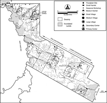
This picture stands in stark contrast to developments that took place during the Epiclassic period, when site number and population exceeded the Olmec period. Settlement patterns for the Epiclassic are illustrated in Figure 2. In the 320 km2 surveyed, 319 sites were recorded, with an estimated population between 6,500 and 14,200 persons (mean = 10,350 persons). The average mean density was approximately 32 persons/km2. The dramatic rise in population suggests that immigration, as well as natural population growth, contributed to population levels in the region. A distinctive architectural style referred to as the “quadripartite complex” accompanied the influx and growth of population. This configuration consisted of two parallel elongated earthen mounds forming a rectangular plaza, with two earthen mounds enclosing each end, one larger than the other.

Epiclassic settlement patterns.
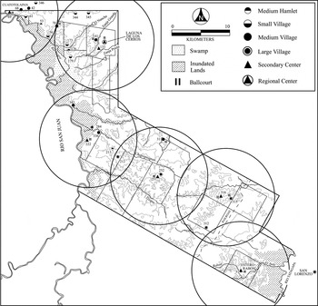
Figure 2 illustrates a number of Secondary and Primary Centers located within the study area. Each is surrounded by lesser administrative sites and rural homesteads. If circles of equal diameter are placed around each, as in Figure 3, it is evident that all are spaced at regular intervals of approximately 13.5 km, forming what appear to be distinct administrative districts. The regular spacing between capitals may relate to the minimization of travel and transportation costs as well as competition between centers (i.e., Inomata and Aoyama 1996; Renfrew 1975). District capitals include Laguna de los Cerros, Cuatotolapan (SLTLC-69), SLTLC-222, SLTLC-251, SLTLC-316, and Estero Rabón (SLTLC-5), occasionally referred to as San Isidro. Often spaced at the boundaries of administrative districts were sites containing quadripartite-complex architecture, only in miniature form. These sites, SLTLC-70, 212, 312, and 343 (Figure 3), also show equidistant spacing. Given the economic importance of religious and secular institutions as reflected by public buildings (i.e., Blanton et al. 1982:46), the presence of miniature replicated ceremonial complexes may represent the administrative and economic links between district capitals and/or capitals and their hinterlands (cf. Johnson 1975:299).

District capitals and other sites with quadripartite complex architecture.
Each district capital possessed a similar architectural grammar—that is, massive quadripartite-complex architecture, a probable ballcourt, and, except for Cuatotolapan, a possible palace structure. Only a few complexes, however, have similar orientations. Cuatotolapan, SLTLC-222, and Estero Rabón, for example, are all oriented east–west, though the principle pyramid at Cuatotolapan sits on the east end and the one at Estero Rabón sits at the west end, and SLTLC-222 contains a double quadripartite complex, one possessing a principal mound on the west and the other on the east. Of the remaining district capitals, Laguna de los Cerros and RLSTLC-251 share an orientation of 10° west of north, and RLSTLC-316 possesses a north–south orientation. All district capitals except Laguna de los Cerros and, to a lesser extent, Estero Rabón appear equal in size. As discussed in greater detail later, Laguna de los Cerros was both qualitatively and quantitatively different.
In addition to district capitals, most secondary and tertiary administrative sites possessed quadripartite-complex architecture (Figure 3). The orientations of lesser administrative sites do not appear to correlate with either political allegiance or noticeable features of the landscape. In this respect, the Cuatotolapan administrative district is illustrative. Within the area surveyed, eight sites were recorded with quadripartite-complex architecture, only two of which have the same orientation. None, moreover, possesses the same orientation as the district capital, Cuatotolapan. In short, the sharing of architectural canons across administrative districts seems to indicate regional coherency, although the variation in quadripartite complex orientations, both across and within administrative districts, suggests a certain degree of political autonomy.
QUADRIPARTITE COMPLEXES
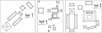
Unlike the Olmec, who left behind little evidence of surface architecture (Cyphers 1997), the inhabitants of southern Veracruz during the Epiclassic period were prodigious builders; their structures ranged from small single mounds to massive quadripartite complexes (Figure 4). A less common variant consisted of a single elongated mound. Twenty-nine sites with quadripartite-complex architecture were recorded in the study area, covering different environmental zones and including all district capitals and other high-ranking sites.

Quadripartite complexes from three sites in the middle San Juan Drainage, Veracruz, Mexico.
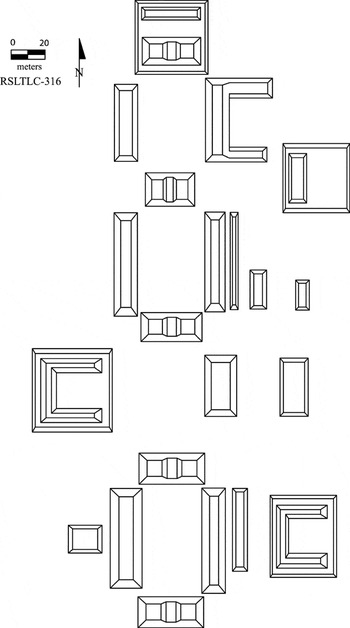
Although the form is repeated from site to site, quadripartite complexes vary in size, orientation, complexity, and number of additional structures. With respect to size, sites with quadripartite-complex architecture in the study area range from 1,223 cm3 to larger than 300,000 cm3. District capitals represent the largest sites. Some of the smallest, already mentioned, are those located at the boundaries of administrative districts. Orientations also vary. Although a north–south, followed by an east–west, orientation is most common, five other orientations have been recorded. This does not take into account the end on which the principal mound is located. That is, two sites with a similar orientation might have their principal mounds located at opposite ends. Finally, variation exists in the complexity of quadripartite complexes. Some sites include double and triple quadripartite complexes, either built side by side or linearly arranged, as in Figure 5. It is currently difficult to account for such variations, although some may be the result of different patterns of growth. While some centers may have grown by increasing the size of extant structures, others may have expanded horizontally through the construction of entirely new buildings.

Three linearly arranged quadripartite complexes. Two share an end mound.
Sites with quadripartite-complex architecture also vary in the number of additional structures. Many of the largest sites possess an elongated parallel mound on the exterior of each of the two principal elongated mounds. Together they may represent a ballcourt (Figure 5). Less common are probable ballcourts independent of the two principal elongated mounds. Large quadrilateral platforms, sometimes supporting low mounds in an “L” or “U” configuration, and a central sunken patio are also common at the largest sites (sites SLTLC-284 and 212 in Figures 4 and 5). None of these platforms has been excavated, and their function remains unclear. Based on analogies with the Maya Lowlands and other regions, such platforms may represent the substructures for elite residences or palaces (Andrews 1975:43; Stark 1999:209).
Quadripartite-complex architecture, as described here, was not limited to the SLTLC area and has been noted by scholars in nearby regions. On both sides of the study area—to the north in the Hueyapan area (Killion and Urcid 2001; see also Ceja Tenorio 1997) and east in the lower Coatzacoalcos drainage near San Lorenzo (Coe and Diehl 1980; Symonds et al. 2002:97–117)—the number of sites with this architectural form appears as numerous as in the SLTLC area. Farther north in the Tuxtlas, the form is noticeably absent, save for a few sites (Santley 1994:Figure 9). West of the Tuxtlas, sites with similar plans are present in the Mixtequilla area near Cerro de las Mesas at the Chivo, Ojochal, and Tio Primo complexes (Stark 1999) and into the Jamapa-Cotaxtla drainage in central Veracruz (Daneels 1997). To the south, the form is present at Medias Aguas (Gómez Rueda 1996:103), Las Limas (Gómez Rueda 1996), and Jonotal (Thomas Killion, personal communication 2002). Farther east, La Venta (Drucker et al. 1959) and Encrucijada 4a (Gómez Rueda 1996:110) contain similar architecture.
Traditionally, sites with quadripartite-complex architecture were either assigned to the Olmec period or were believed to be Epiclassic in date but derived from an original Olmec pattern. It is likely that confusion has arisen because Epiclassic people consistently occupied areas of earlier Olmec sites, thus obscuring the ascription of structures to either period. Also, few quadripartite complexes have actually been excavated; consequently, their chronological placement in the Olmec period is often assumed rather than proved. Such an assumption may stem from the belief that the Olmec were the progenitors of mound and plaza architecture in Mesoamerica. Limited excavations at Tenochtitlán (Coe and Diehl 1980:38–39), San Lorenzo (Coe and Diehl 1980:50–55), Laguna de los Cerros (Cyphers 2001), and Las Limas (Gómez Rueda 1996:64–65), however, suggest that the quadripartite complex—at least, at those sites—is Epiclassic in date.3
Symonds and colleagues (2002:109) argue that, on close inspection, Mound C3-3 at San Lorenzo, one of the elongated parallel mounds in Group A and dated to the Middle Formative (Coe and Diehl 1980:60–70), appears to rest on an Epiclassic surface, thus dating C3-3 to the Epiclassic, as well.
Taking a larger regional perspective, regions to the north and northwest, though more peripheral to the Olmec florescence, show greater cultural continuity back to the Formative period. Such is the case for the Cotaxtla drainage, the Mixtequilla, and the Hueyapan area. Many scholars have also noted architectural similarities in the formal layout of La Venta, which is most notable for its Olmec occupation. It should be noted, however, that while the principal conical mound at the site, C-1, is believed to date to the Olmec period, it has not been excavated save for a small trench in the apron upon which the pyramid rests (Drucker et al. 1959:119). The carbon sample taken was from fill and does not necessarily date to the period that the mound was constructed (Coe and Stuckenrath 1964:16). Likewise, as noted by Richard Diehl (1981:77–78), it is difficult to assign a date to one of the excavated elongated parallel mounds, A-5, and the other elongated parallel mound, A-4, has not been excavated. In short, the inception and origin of this architectural pattern await further excavations.
POLITICAL ORGANIZATION DURING THE EPICLASSIC PERIOD
As mentioned, the sharing of architectural canons across administrative districts and the variation in the orientations of quadripartite complexes indicate regional coherence but also a degree of political autonomy. At present, it is not possible to account for the type of political organization that existed in the region during the Epiclassic. A refinement of the ceramic chronology and excavations of quadripartite complexes are necessary to assess issues of function and temporality. Nevertheless, as a first attempt, it is instructive to examine two models of political organization located at the polar ends of a continuum. A segmental model of political organization is based on a decentralized, replicated, and unintegrated structure. In contrast, the unitary model is based on a centralized, differentiated, and integrated political structure. Segmental versus unitary political systems are commonly debated in the Maya area (Fox et al. 1996); both models appear germane to southern Veracruz, as well.
A. W. Southall (1956) described segmentary polities as semiautonomous districts that represent political duplications of one another. As mentioned, they have low degrees of centralization, differentiation, and integration characterized by both political affinity and autonomy. Within the administrative hierarchy, similar political functions are repeated at each level, only on a decreasing scale. That is, provincial centers mirror the capital but in reduced form. The recognizable powers of each subcenter make heterarchical relationships important. Economically, the basic organizational unit, the segmentary lineage, possessed its own property composed of elite estates and corporate holdings that insured economic independence from other lineages. Each, moreover, maintained its own positions of leadership and self-rule. Lineages were ranked by the degree to which they were descended from a common ancestor. Thus, the overarching cohesiveness of many segmental polities was through ritual and kinship (Fox et al. 1996:795).
A segmentary model seems at least partially supported in the study area. Most obvious is that the study area is composed of administrative districts of equal size, each with a similar settlement system made up of a capital with quadripartite architecture, lesser administrative sites, and a rural hinterland. The sharing of architectural canons across administrative districts indicates regional coherence, but the variation in quadripartite-complex orientations suggests overall political autonomy. Within administrative districts, the replication of quadripartite complexes at differing hierarchical scales may represent the scaling down of identical political functions. Quadripartite complexes may have been the markers for elite estates bound together through kinship, ideology, political, and, possibly, economic functions.
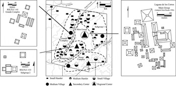
Data also partially support a unitary model, however. Recall that the capital of Laguna de los Cerros was both qualitatively and quantitatively larger than other district capitals. Two streams bound this site on the west and east, the Zanja Grande and Zanja Prieta. Based on excavations and surface reconnaissance, Laguna de los Cerros has tentatively been divided into a main core containing the largest civic-ceremonial architecture and two subgroups to the north and south, each with their own internal organization. Site SLTLC-133, for example, centrally dominated Subgroup 2 and contained quadripartite-complex architecture (Figure 6). The subgroups are connected to the main core by an intervening area of light but continuous occupation. On the sides opposite the two streams appear separate architectural complexes, the Grande complex and Prieta complex, each composed of a cluster of sites. Each has its own internal organization and is dominated by a centrally positioned large site (Figure 6). The estimated population for Laguna de los Cerros and its two complexes is between 3,465 and 7,515 persons (mean = 5,490 persons). That is, within the entire survey area, more than half the population resided around Laguna de los Cerros.

Settlement pattern of Laguna de los Cerros, including Grande Complex and Prieta Complex.
In many ways, the internal hierarchy that characterizes Laguna de los Cerros approximates what Olivier de Montmollin (1989) has described for the capital site of Tenam Rosario in Chiapas. There, de Montmollin (1989:153) depicts the capital as a political “microcosm” of its hinterland, with an internal hierarchy of sites and complexes representing the levels of hierarchy found outside the capital. Extending this model to Laguna de los Cerros, there are two ways to relate the internal organization to the larger regional political hierarchy. One is to view all internal political levels as hierarchically above all Secondary Centers in the hinterland. The other is to view only the topmost level—that is, the main core—as hierarchically above other Secondary Centers in the hinterland. In this way, Secondary Centers within Laguna de los Cerros would be equivalent to Secondary Centers in the hinterland (de Montmollin 1989:165, 227).
Related to the idea of a microcosm is Barbara Stark's (1999) concept of a “capital zone.” In the Mixtequilla area of south-central Veracruz, Stark reports a pattern of closely spaced architectural complexes of differing size. She posits two possible explanations with respect to political organization. One is that closely spaced architectural complexes represent secondary and tertiary centers within a regional hierarchy. The other is that distinct but closely spaced complexes correspond to a core zone that formed a superordinate administrative capital, or a capital zone. Both the microcosm and capital-zone models merit further investigation with respect to Epiclassic political organization at Laguna de los Cerros.
DISCUSSION
Research in the SLTLC area, along with other recent studies conducted in nearby regions, provides fresh insight into the Epiclassic period in the southern Gulf lowlands. Traditionally conceived as a monolithic region associated primarily with the Formative-period Olmec, this region of Mesoamerica is in fact better characterized by cultural variation, spatial and temporal discontinuity, and intra- and interregional interaction (Arnold and Stark 1997:322). The study area, which during the Formative period witnessed the great Olmec florescence, became largely abandoned for nearly 1,000 years, until the close of the Classic period. This depopulation was part of a larger regional phenomenon that extended east to the lower Coatzacoalcos drainage and possibly all the way to the Tonala drainage and Grijalva Delta. By contrast, at the same time, areas to the north of the study area, in the Tuxtlas and extending to the Mixtequilla and Cotaxtla drainage, were characterized by population growth. By the Epiclassic, however, population had once again shifted. This time, the study area, other parts of the middle San Juan drainage, and the lower Coatzacoalcos drainage experienced a resurgence in population (Borstein 2001; Killion and Urcid 2001; Symonds et al. 2002). The Tuxtlas, however—especially around Matacapan—became largely depopulated (Santley and Arnold 1996).
Within a relatively short period of time, populations in the study area became organized into relatively evenly spaced administrative districts, each characterized by a capital site, smaller administrative sites, and a hinterland population. All capital sites, as well as many secondary and tertiary centers, followed a similar architectural grammar referred to as the quadripartite complex. Of the district capitals mentioned, Laguna de los Cerros stood above the rest in terms of size and internal complexity and at some point may have controlled other administrative districts. One possible explanation for the political importance of Laguna de los Cerros during the Epiclassic, and likely also for the Formative, was that it lay along a strategic node in a transportation and communication corridor that connected southern Veracruz with other regions of Mesoamerica. It was strategically wedged between two fluvial systems, the San Juan/Negra River system to the south and the Hueyapan/Amayo/Cuitlazoyotl River system to the north. It also sat along a naturally elevated terrestrial corridor that runs east to the lower Coatzacoalcos drainage and west into the Sierra de los Tuxtlas. Even during the Colonial period, a major trade route passed by a nearby hacienda that ran toward the Tuxtlas and onto Tlacotalpan and Alvarado in south-central Veracruz. In the modern era, a major highway passes by the nearby town of Corral Nuevo.
The organization of population into administrative districts was not limited to the SLTLC area. North of the study area in the Hueyapan area, Killion and Javier Urcid (2001) report populations grouped around formal sites with quadripartite architecture, which may represent the capitals of administrative districts. East of the study area in the lower Coatzacoalcos drainage around San Lorenzo, Symonds and colleagues (2002:97–117) also report the formation of administrative districts composed of capital sites with quadripartite-complex architecture. There, the site of Ahuatepec4
The site of Tenochtitlan is often regarded as the primary site in the San Lorenzo region during the Epiclassic, but the primary site is in fact Ahuatepec.
The rapid population increase that took place in the study area, as well as to the east, suggests a significant influx of immigrants. The origin of these people remains elusive. One possible donor region was the Tuxtla Mountains, which was declining in population just as the study area was fluorescing (Santley and Arnold 1996:245). The Tuxtlas, with ties to Teotihuacan via Matacapan, may also account for some ceramic forms found in the study area, such as the ubiquitous Fine Orange hemispherical bowl with annular base, which is strongly reminiscent of central Mexican Thin Orange forms of earlier times. The Tuxtlas appear less able to account for the appearance of quadripartite-complex architecture, since the form there is nearly absent.
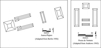
Another potential donor region was the Maya Lowlands. Recent climatic studies have suggested a severe drought that affected much of the lowlands, especially the Candelaria River area, beginning about a.d. 750 and coinciding with the Maya Collapse (Gunn and Folan 2000; Hodell et al. 2001). Although no similar climatic studies are available for the study area, the middle San Juan and lower Coatzacoalcos drainages may have represented a close refuge for many peoples leaving the Maya region. Architectural similarities, moreover, can be found at a few sites located at the edge of the Classic Maya heartland. The clearest examples come from the sites of Pájaro (Ochoa and Vargas 1979:72; also called Juarez in Berlin 1956:Figure 2C), near the mouth of the Grijalva River; Pozas de Ventura (Andrews 1943:Figure 11), on the Candelaria River; Arenal (Ochoa 1996:Figure 4), along the Usumacinta River; and Cocoyoles (Ball 1978:82; Eaton 1978:20), on the Isla de Carmen in the Laguna de Términos (Figure 7). Although the chronological sequences of these sites are poorly understood, they all appear to be Late Classic or Epiclassic in date. Equally interesting, these sites are specifically associated with the Chontal Maya (Ball 1978:82; Fox 1987; Ochoa and Vargas 1979).

Architectural complexes from two reputed Chontal sites.
The Chontal resided in the drainages of the lower Usumacinta, lower Grijalva, San Pedro and Pablo, and Candelaria, as well as on the coasts of Campeche and Tabasco (Scholes and Roys 1948). Archaeologically they are associated with the distribution of various Fine Orange and Fine Gray wares, such as the Balancan and Altar Fine Orange and Chablekal and Tres Naciones Fine Gray groups (e.g., Sabloff 1975). They are also associated with Z-Fine Orange ware of the late Late Classic to Early Postclassic Jonuta Horizon (Berlin 1956:147). Southern Veracruz, too, is characterized by Fine Orange and Fine Gray wares, although, with a few exceptions related to Z-Fine Orange ware, the Chontal and SLTLC areas have distinct ceramic forms.
In sum, much more work is needed to establish the origins of people who immigrated to the middle San Juan and lower Coatzacoalcos drainages during the Epiclassic period. Currently, there are a number of possibilities. It may well be that immigration was the result of multiple donor regions, which would be appropriate for a region often said to represent a crossroads in Mesoamerica.
CONCLUSION
The Epiclassic period represents the largest aggregation of people in southern Veracruz during the pre-Hispanic era. Within a relatively short period of time, a regional hierarchy of sites had developed composed of administrative districts, each with a district capital, lesser administrative sites, and a rural hinterland. Two models were introduced to assess, in a preliminary way, how administrative districts might have been related. Currently, there are data to support aspects of both the segmentary and unitary models. The former finds support in the seemingly equal size and regular spacing of administrative districts. The replication of a distinct architectural grammar across district capitals indicates regional coherence, although the variation in quadripartite-complex orientations suggests overall political autonomy. Within administrative districts, the replication of quadripartite complexes at differing scales may represent the repetitiveness of identical functions but on a decreasing scale.
A more centralized unitary model finds support in the fact that Laguna de los Cerros was larger than other capitals and possessed its own internal hierarchy, which no other capital possessed. In many ways, the internal complexity at Laguna de los Cerros approximates de Montmollin's (1989) “microcosm” and Stark's (1999) “capital zone.” If Laguna de los Cerros was indeed the capital of a larger regional state, its territorial boundaries may have been half the distance between it and two other very large sites each located approximately 60 km away: Ahuatepec to the east and Jonotal to the south. Segmental and unitary models are clearly only starting points for future research. Quite possibly, cycles of supradistrict centralization and subsequent balkanization were the norm (Marcus 1993).
Connecting all districts was a normative architectural pattern. In what John Baines and Norman Yoffee (1998) refer to as “high culture,” the quadripartite complex represented the visual expression of intellectual, spiritual, and political knowledge created and sustained by elites. Undoubtedly, the quadripartite complex was the seat of local political authority and the place where administration, adjudication, public rituals, and religious activities took place. The quadripartite nature of the civic-ceremonial core is likely to have been a metaphor for the center of the cosmos or axis mundi. By placing themselves in this center, elites exploited high culture for purposes of legitimacy.
At present, reasons for the various orientations in quadripartite complexes are unknown. In the SLTLC area, orientations do not appear to correlate with either political allegiance or natural features of the landscape. In the lower Coatzacoalcos drainage near San Lorenzo, Symonds and colleagues (2002:111–117) note a greater degree of intradistrict conformity, which may relate to political allegiance. In the Hueyapan area, Killion and Urcid (2001) attribute site orientation to natural features such as the Tuxtlas or to other important administrative sites. Another possibility comes by way of analogy. For the Quiché Maya, purported desendants of the Chontal Maya, the orientation of civic-ceremonial complexes, some of which are remarkably similar to those in southern Veracruz (e.g., Fox 1987:81), seems to have been related to the alignment of lineages with certain deities, each of which was associated with a specific direction (Fox 1978:63). Such an explanation for sites in the southern Gulf lowlands remains a hypothesis for future research.
The southern Gulf lowlands witnessed remarkable periods of cultural growth and dissolution throughout its history. Of these, the Olmec period continues to be the best understood. This area played another key role in Mesoamerica during the Epiclassic, and the details of this period have only recently come to light. A better understanding of the Epiclassic will undoubtedly be important in considering concomitant developments in other regions, such as the Maya region and central Mexico, during one of Mesoamerica's most tumultuous periods.
RESUMEN
Las investigaciones arqueológicas en el sur de Veracruz, México, se han centrado tradicionalmente en los logros impresionantes del Los Olmecas formativo temprano, una de las sociedades complejas más tempranas de Mesoamerica. Menos estudios han investigado los desarrollos culturales desde los Olmecas. Investigaciónes en partes del los drenajes San Juan y Coatzacoalcos del sur de Veracruz proporciona nuevos datos en el período de epiclassico, cuando los niveles de la población excedieron el período olmeca. Examinos los patrones de asentamiento regionales y complejos arquitectónicos para interpretar la organización política existente durante el epiclassico. Se examinan dos modelos políticos en gran parte polarizados, uno segmentado y el otro centralizado. Quizás no sorprendentemente, los datos son consistentes con aspectos de ambos modelos. Ultimamente, los datos son comparados con otras regiones cercanas para colocar el área del estudio en un contexto regional más grande. Concebido tradicionalmente como región monolítica, las tierras bajas del Golfo son caracterizadas mejor por la variación cultural, discontinuidades de la población, y la interacción intra- e inter-regional.
ACKNOWLEDGMENTS
I extend my deepest thanks to Ann Cyphers, David Grove, Kenneth Hirth, and Barbara Stark, who read drafts of this paper, answered questions, supplied sources, and offered guidance. This paper also benefited from the generous efforts of Philip Arnold, Antonio Curet, Gary Feinman, Jonathan Haas, Thomas Killion, and Robert Santley. I am responsible for any errors in content and interpretation.
References
REFERENCES
Andrews, E. Wyllys, IV
1943
The Archaeology of Southwestern Campeche.
Contributions to American Anthropology and History Vol. 8, No. 40.
Carnegie Institution of Washington, Publication 546.
Carnegie Institution of Washington,
Washington, DC.
Andrews, George F.
1975
Maya Cities, Placemaking and Urbanization.
University of Oklahoma Press,
Norman.
Arnold, Philip J., III, and
Barbara L. Stark
1997
Gulf Lowland Settlement in Perspective. In
Olmec to Aztec: Settlement Patterns in the Ancient Gulf
Lowlands, edited by
Barbara L. Stark and
Philip J. Arnold III, pp.
310–329.
University of Arizona Press,
Tucson.
Baines, John, and
Norman Yoffee
1998
Order, Legitimacy, and Wealth in Ancient Egypt and
Mesopotamia. In
Archaic States, edited by
Gary M. Feinman and
Joyce Marcus, pp.
199–260.
Advanced Seminar Series.
School of American Research,
Santa Fe, NM.
Ball, Joseph W.
1978
Archaeological Pottery of the Yucatan-Campeche Coast.
Middle American Research Institute Publication 46.
Tulane University,
New Orleans.
Berlin, Heinrich
1956
Late Pottery Horizons of Tabasco, Mexico.
Carnegie Institution of Washington, Publication 606, Contributions
to American Anthropology and History 59.
Carnegie Institution of Washington,
Washington, DC.
Blanton, Richard E.,
Stephen Kowalewski,
Gary Feinman, and
Jill Apple
1982
Monte Alban's Hinterland, Part I: The Prehispanic Settlement
Patterns of the Central and Southern Parts of the Valley of Oaxaca,
Mexico.
Memoirs No. 15.
Museum of Anthropology, University of Michigan,
Ann Arbor.
Borstein, Joshua A.
2001
Tripping over Colossal Heads: Settlement Patterns and Population
Development in the Upland Olmec Heartland.
Unpublished Ph.D. dissertation,
Department of Anthropology, Pennsylvania State University,
State College.
Ceja Tenorio, Jorge Fausto
1997
Los sitios arqueológicos del suroeste de los Tuxtlas.
In
Memoria del Coloquio Arqueología del Centro y Sur de
Veracruz, edited by
Sara Ladrón de Guevara
González and
Sergio Vásquez Zárate,
pp.
177–196.
Universidad Veracruzana,
Xalapa.
Coe, Michael D., and
Richard A. Diehl
1980
The Archaeology of San Lorenzo Tenochtitlan, Volume 1: In the Land
of the Olmec.
University of Texas Press,
Austin.
Coe, William R., and
Robert Stuckenrath, Jr.
1964
A Review of La Venta, Tabasco and Its Relevance to the Olmec
Problem. In
The Kroeber Anthropological Society Papers,
no. 31, pp.
1–43.
Department of Anthropology,
University of California, Berkeley.
Cyphers, Ann
1997
Olmec Architecture at San Lorenzo. In
Olmec to Aztec: Settlement Patterns in the Ancient Gulf
Lowlands, edited by
Barbara L. Stark and
Philip J. Arnold III, pp.
96–114.
University of Arizona Press,
Tucson.
Cyphers, Ann
2001
La cerámica de Laguna de los Cerros. Manuscript on file,
Archives of the San Lorenzo Tenochtitlán Archaeological Project,
Instituto de Investigaciones, Antropológicas, UNAM, Mexico
City.
Daneels, Annick
1997
Settlement History in the Lower Cotaxtla Basin. In
Olmec to Aztec: Settlement Patterns in the Ancient Gulf
Lowlands, edited by
Barbara L. Stark and
Philip J. Arnold III, pp.
206–252.
University of Arizona Press,
Tucson.
de Montmollin, Olivier
1989
The Archaeology of Political Structure, Settlement Analysis in a
Classic Maya Polity.
Cambridge University Press,
New York.
Diehl, Richard A.
1981
Olmec Architecture: A Comparison of San Lorenzo and La
Venta. In
The Olmec and Their Neighbors, edited by
E.P. Benson, pp.
69–81.
Dumbarton Oaks Research Library and Collections,
Washington, DC.
Drucker, Philip,
Robert F. Heizer, and
Robert J. Squier
1959
Excavations at La Venta, Tabasco, 1955.
Bureau of American Ethnology Bulletin 170.
Smithsonian Institution,
Washington, DC.
Eaton, Jack D.
1978
Archaeological Survey of the Yucatan-Campeche Coast.
Middle American Research Institute Publication 46.
Tulane University,
New Orleans.
Fox, John W.
1978
Quiché Conquest, Centralism and Regionalism in Highland
Guatemalan State Development.
University of New Mexico Press,
Albuquerque.
Fox, John W.
1987
Maya Postclassic State Formation.
Cambridge University Press,
Cambridge.
Fox, John W.,
Garrett W. Cook,
Arlen F. Chase, and
Diane Z. Chase
1996
Questions of Political and Economic Integration: Segmentary versus
Centralized States among the Ancient Maya.
Current Anthropology
37(5):795–801.Google Scholar
Gómez Rueda, Hernando
1996
Las Limas, Veracruz, y otros asentamientos prehispánicos de
la región Olmeca.
Colección Científica.
Instituto Nacional Antropología e Historia,
Mexico City.
Gunn, Joel D., and
William J. Folan
2000
Three Rivers: Subregional Variations in Earth System Impact in the
Southwestern Maya Lowlands (Candelaria, Usumacinta, and Chapoton
Watersheds). In
The Way the Wind Blows: Climate, History and Human Action,
edited by
R.J. McIntosh,
J.A. Tainter, and
S. Keech McIntosh, pp.
223–271.
Columbia University Press,
New York.
Hodell, David A.,
Mark Brenner,
Jason H. Curtis, and
Thomas Guilderson
2001
Solar Forcing of Drought Frequency in the Maya Lowlands.
Science
292(5520):1367–1370.Google Scholar
Inomata, Takeshi, and
Kazuo Aoyama
1996
Central-Place Analyses in the La Entrada Region, Honduras:
Implications for Understanding the Classic Maya Political and Economic
Systems.
Latin American Antiquity
7(4):291–312.Google Scholar
Johnson, Gregory A.
1975
Locational Analysis and the Investigation of Uruk Local Exchange
Systems. In
Ancient Civilization and Trade, edited by
Jeremy A. Sabloff and
C.C. Lamberg-Karlovsky, pp.
285–339.
University of New Mexico Press,
Albuquerque.
Judge, W. James,
James I. Ebert, and
Robert K. Hitchcock
1975
Sampling in Regional Archaeological Survey. In
Sampling in Archaeology, edited by
J.W. Mueller, pp.
82–123.
University of Arizona Press,
Tucson.
Killion, Thomas W., and
Javier Urcid
2001
The Olmec Legacy: Cultural Continuity on Mexico's Southern Gulf
Coast.
Journal of Field Archaeology,
28:3–25.Google Scholar
Marcus, Joyce
1993
Ancient Maya Political Organization. In
Lowland Maya Civilization in the Eighth Century A.D., edited
by
Jeremy A. Sabloff and
John S. Henderson, pp.
111–183.
Dumbarton Oaks Press,
Washington, DC.
Ochoa, Lorenzo
1996
Imaginación y arqueología: Problemas y limitaciones
en los estudios del patrón de asentamiento en la cuenca del San
Pedro Mártir, Tabasco. In
Arqueología mesoamericana: Homenaje a William T. Sanders,
vol. 2, edited by
Alba G. Mastache,
Jeffrey R. Parsons,
Robert S. Santley, and
Mari C. Serra Puche, pp.
63–77.
Instituto Nacional Arqeologíca e Historia,
Mexico City.
Ochoa, Lorenzo, and
Ernesto Vargas
1979
El colapso maya, los chontales y Xicalango.
Estudios de cultura maya
12:61–91.Google Scholar
Pool, Christopher A.
2000
From Olmec to Epi-Olmec at Tres Zapotes, Veracruz, Mexico.
In
Olmec Art and Archaeology in Mesoamerica, edited by
John E. Clark and
Mary E. Pye, pp.
137–153.
National Gallery of Art,
Washington, DC.
Renfrew, Colin
1975
Trade as Action at a Distance: Questions of Interaction and
Communication. In
Ancient Civilization and Trade, edited by
Jeremy A. Sabloff and
C.C. Lamberg-Karlovsky, pp.
3–59.
University of New Mexico Press,
Albuquerque.
Rust, William F., and
Barbara W. Leyden
1994
Evidence of Maize Use at Early and Middle Preclassic La Venta Olmec
Sites. In
Corn and Culture in the Prehispanic New World, edited by
S. Johannessen and
C.A. Hastorf, pp.
181–201.
Westview Press,
Boulder, CO.
Rust, William F., and
Robert J. Sharer
1988
Olmec Settlement Data from La Venta, Tabasco, Mexico.
Science
242:102–104.Google Scholar
Sabloff, Jeremy A.
1975
Excavations at Seibal: Ceramics.
Memoirs of the Peabody Museum of Archaeology and Ethnology, Vol.
13, No. 2.
Harvard University,
Cambridge, MA.
Sanders, William T.,
Jeffrey Parsons, and
Robert Santley
1979
The Basin of Mexico: Ecological Processes in the Evolution of a
Civilization.
Academic Press,
New York.
Santley, Robert S.
1994
The Economy of Ancient Matacapan.
Ancient Mesoamerica
5:243–266.Google Scholar
Santley, Robert S., and
Philip J. Arnold III
1996
Prehispanic Settlement Patterns in the Tuxtla Mountains, Southern
Veracruz, Mexico.
Journal of Field Archaeology
23:225–249.Google Scholar
Santley, Robert S.,
Philip J. Arnold III, and
Thomas P. Barrett
1997
Formative Period Settlement Patterns in the Tuxtla
Mountains. In
Olmec to Aztec: Settlement Patterns in the Ancient Gulf
Lowlands, edited by
Barbara L. Stark and
Philip J. Arnold III, pp.
175–205.
University of Arizona Press,
Tucson.
Scholes, France V., and
Ralph L. Roys
1948
The Maya Chontal Indians of Acalan-Tischel,
2nd ed.
University of Oklahoma Press,
Norman.
Sisson, E.B.
1976
Survey and Excavation in the Northwestern Chontalpa, Tabasco,
Mexico.
Unpublished Ph.D. dissertation,
Department of Anthropology, Harvard University,
Cambridge, MA.
Southall, A.W.
1956
Alur Society.
Oxford University Press,
Oxford.
Stark, Barbara L.
1999
Formal Architectural Complexes in South-Central Veracruz, Mexico: A
Capital Zone?
Journal of Field Archaeology
26:197–225.Google Scholar
Stark, Barbara L., and
Antonio L. Curet
1994
The Development of Classic-Period Mixtequilla in South-Central
Veracruz, Mexico.
Ancient Mesoamerica
5:267–287.Google Scholar
Symonds, Stacey,
Ann Cyphers, and
Roberto Lunagómez
2002
Asentamiento prehispánico en San Lorenzo Tenochtitlán,
Veracruz, Mexico.
Instituto de Investigaciones Antropológias,
Universidad Nacional Autónoma de México, Mexico
City.
von Nagy, Christopher
1997
The Geoarchaeology of Settlement in the Grijalva Delta. In
Olmec to Aztec: Settlement Patterns in the Ancient Gulf
Lowlands, edited by
Barbara L. Stark and
Philip J. Arnold III, pp.
253–277.
University of Arizona Press,
Tucson.
Epiclassic settlement patterns.
District capitals and other sites with quadripartite complex architecture.
Quadripartite complexes from three sites in the middle San Juan Drainage, Veracruz, Mexico.
Three linearly arranged quadripartite complexes. Two share an end mound.
Settlement pattern of Laguna de los Cerros, including Grande Complex and Prieta Complex.
Architectural complexes from two reputed Chontal sites.
 You have
Access
- 14
- Cited by