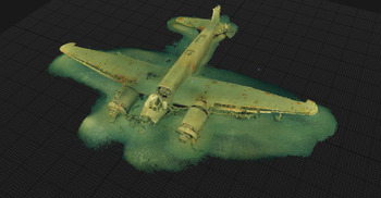
This brief review assesses a dynamic virtual exhibition that has been curated by the University of Malta and Heritage Malta, with the support of the Malta Tourist Authority and the backing of the Ministry of Tourism and Consumer Protection, Malta. The exhibition, Underwater Malta (https://underwatermalta.org/map/), aims, through a virtual platform, to explore 17 wrecks ranging in date from a 2700-year-old Phoenician shipwreck found off Gozo to a submarine and numerous ships that sank in the Second World War, and a Victorian gun (cannon) site. The most numerous wreck type is aircraft, with nine that were active in the Second World War (Figure 1). While the wrecks are unified by their underwater resting place, the material, their chronologies and the depths at which they are located on the seabed vary considerably, the deepest being the Phoenician shipwreck that lies beneath 110m of water.
3D interactive model of a crashed Second World War Ju88 aircraft (figure courtesy of University of Malta/Heritage Malta).

The Underwater Malta virtual museum enables viewers to approach the wrecks through a number of means. There is an interactive map showing the exact location of each wreck site and allowing direct access to the images and information. Alternatively, the sites can be viewed through interactive images on the ‘grid view’, which is essentially an icon that encourages you to discover each individual site.
Besides the wrecks themselves, other sections provide context for the exhibition. A section entitled ‘The Project’ outlines the overall aim of the virtual exhibition and also the methodological approaches adopted in the data collection. The project team are introduced in a separate section entitled ‘The Team’, together with their specialist rebreather diving equipment. The sites are documented through images captured on powerful cameras, with the help of underwater lights. High-resolution imagery is converted into 3D models that are created from a set of overlapping photographs in a process known as photogrammetry. Often many hundreds, if not thousands, of photographs were required to produce the virtual reality models.
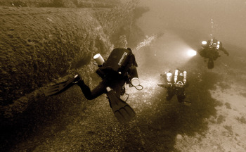
The data relating to each wreck site are presented consistently throughout the exhibition. Locational coordinates and the depth of the vessels underwater are provided for each site. Each entry includes a description of the wreck, its date of construction and wrecking (where known), together with information about its working history. A 3D virtual reality model has been generated for each wreck. The model enables the viewer to explore the wreck in detail, zooming in on specific features and viewing the wrecks from various angles. Specific features are targeted to draw attention to interesting attributes of the wrecks, enabling the viewer to go directly to the highlighted feature in its exact location on the vessel. For example, on the 3D model of HMS Stubborn, an S-class submarine, the torpedo tubes, conning tower and propellers are explored, both in specific detail and more generally. The 3D virtual reality capacity of the exhibition obviously speaks to one of its main objectives, that of access—specifically access to the underwater world, considering that the majority of viewers cannot dive, and even those that can may not necessarily be trained to dive using such technical equipment or to such depths (Figure 2).
HMS Sutton during investigation (figure courtesy of University of Malta/Heritage Malta).

A video of each site has also been produced. The majority present the 3D model of the wreck on the seabed, but sometimes, as for example in the case of the Phoenician shipwreck, the video shows the team investigating the wreck, providing a sense of the reality of diving on these sites, particularly at such depth.
A gallery of images relating to each vessel, is also presented. This includes where possible: images of the vessels when operational; divers investigating the wrecks on the seabed; the 3D and seismic images of the sites; and maps and plans of the vessel's design. In the gallery entry for the X-Lighter supply vessel (X-127) that was lost off Lazzaretto Wharf, Manoel Island, where it had supported the 10th Submarine Flotilla throughout the Second World War, there is even an image of the vessel being bombed and sinking in 1942.
The final sections provide further context to the location of the underwater finds. ‘The Islands’ is a short text that introduces the island nature of Malta and Gozo, while another section references the context of ‘Shipwrecks and the law’ in this region.
The virtual exhibition is presented on a black screen with contrasting white and yellow text, which is atmospheric and gives the impression of being immersed at depth underwater. The blocks of text, while hugely informative, are at times quite dense, even for a virtual display. The quality of the images, in particular the underwater photographs, is, however, of a very high standard, and the exhibition is easily navigable, restricted only by internet stability.
This exhibition allows the viewer to approach a corpus of material that many would never be able to access. It is very informative, not only about the wrecked vessels and their biographies, but also the context and role of maritime craft in the region through time. It particularly speaks to the role of Malta, especially during the Second World War. This is highlighted by the extensive number of underwater wrecks in the region, with a particular concentration around Valetta and the Grand Harbour. It is only regrettable that there is no map of the modern coastal towns of the islands to give a sense of the distribution of wreckage in relation to coastal settlements, past and present.
Overall, this excellent exhibition will not only be of interest to maritime archaeologists and historians, but will also be enjoyed by those attracted to the regional history of Malta, 3D modelling and, importantly, viewers interested in the exciting new world of virtual museum exhibitions, something we will no doubt see more of in the future.