



Introduction
In the oldest story of Stonehenge's origins, the History of the Kings of Britain (c. AD 1136), Geoffrey of Monmouth describes how the monument was built using stones from the Giants’ Dance stone circle in Ireland. Located on legendary Mount Killaraus, the circle was dismantled by Merlin and shipped to Amesbury on Salisbury Plain by a force of 15 000 men, who had defeated the Irish and captured the stones. According to the legend, Stonehenge was built to commemorate the death of Britons who were treacherously killed by Saxons during peace talks at Amesbury. Merlin wanted the stones of the Giants’ Dance for their magical, healing properties.
This 900-year-old legend is fantasy: the Saxons arrived not in prehistory, but only 700 years before Geoffrey's own time, and none of Stonehenge's stones came from Ireland. Yet the fact that Stonehenge's ‘bluestones’ derive from Wales—far to the west of Salisbury Plain—has led to speculation that there may be some truth in Geoffrey's pseudo-history (Piggott Reference Piggott1941; Burl Reference Burl2006: 19–21; Darvill & Wainwright Reference Darvill and Wainwright2009). Moreover, at the time Geoffrey was writing, this region of south-west Wales was considered Irish territory (Davies Reference Davies1982: 87–88 & 95, Reference Davies1990: 39; Thomas Reference Thomas1994: 51–112). One possibility is that the bluestones did indeed derive from a stone circle in west Wales, which was dismantled and re-erected as Stonehenge. A similar conclusion was reached a century ago by geologist Herbert Thomas, who established that the spotted dolerite bluestones at Stonehenge originated in the Preseli Hills of west Wales, where, he suspected, they had originally formed a “venerated stone-circle” (Thomas Reference Thomas1923: 258).
From the perspective of our ‘Stones of Stonehenge’ project (Parker Pearson et al. Reference Parker Pearson2015a, Reference Parker Pearson2019), the hypothesis that Stonehenge was built for the ancestors could be expanded to explain the significance of the bluestones as markers of ancestral identity that originally formed a circle or monument in Preseli (Parker Pearson & Ramilisonina Reference Parker Pearson and Ramilisonina1998). Our previous excavations at Stonehenge have provided evidence that the bluestones were first set up in the Aubrey Holes (the ring of pits that surround the stone circle) during the monument's first construction stage, beginning in 3080–2950 cal BC (95% probability; Parker Pearson et al. Reference Parker Pearson, Chamberlain, Jay, Marshall, Pollard, Richards, Thomas, Tilley and Welham2009, Reference Parker Pearson, Pollard, Richards, Thomas, Tilley and Welham2020: 163–69 & 527–46; Darvill et al. Reference Darvill, Marshall, Pearson and Wainwright2012). Thus, a hypothetical original, dismantled stone circle in Wales would date to this period or earlier.
The identification and excavation of bluestone megalith quarries at Craig Rhos-y-felin and Carn Goedog in the Preseli Hills, which yielded evidence suggesting that they date to c. 3400–3000 cal BC, narrows the search for a dismantled stone circle to a setting of former standing stones at Waun Mawn (Figure 1; Parker Pearson et al. Reference Parker Pearson2015a, Reference Parker Pearson2019). These four monoliths—three now recumbent—originally stood in an arc, and were identified a century ago as remnants of a stone circle (Royal Commission on the Ancient and Historical Monuments of Wales 1925: 258–59). Later researchers, however, classified this site as ‘doubtful or negative’ and ‘destroyed or unrecognisable’ (Grimes Reference Grimes, Foster and Alcock1963: 150; Burl Reference Burl1976: 371).
Location of the dismantled stone circle of Waun Mawn (red-ringed circle), as well as the bluestone sources of Carn Goedog (spotted dolerite), Craig Rhos-y-felin (rhyolite) and Cerrigmarchogion (unspotted dolerite). The locations of the Neolithic causewayed enclosure of Banc Du and palisaded enclosure of Dryslwyn (black-ringed circles), as well as Early Neolithic portal tombs (black squares), are also shown (map by M. Parker Pearson).

A dismantled stone circle at Waun Mawn
The ‘Stones of Stonehenge’ project identified Waun Mawn as a site of interest in 2010, but magnetometer and earth-resistance surveys in 2011 failed to locate any geophysical anomalies indicative of stoneholes. Subsequently, Waun Mawn was left unexplored while we investigated other sites in the vicinity. Although numerous circular monuments were surveyed and excavated between 2012 and 2017, none was found to be Neolithic (e.g. Parker Pearson et al. Reference Parker Pearson, Casswell and Welham2017, Reference Parker Pearson, Casswell and Welham2018; Casswell et al. Reference Casswell, Comeau and Pearson2018).
In 2017, we returned to Waun Mawn, excavating trenches at both ends of the arc to discover two stoneholes without stones (Figure 2). Realising that magnetometry was unsuitable for the non-magnetic substrate of glacial drift deposits, in 2018 we undertook further surveys using earth resistance, ground-penetrating radar (GPR) and electromagnetic induction. The results were disappointing due to the minimally magnetic and conductive properties of the substrate. It became clear that only archaeological excavation could reveal further stoneholes.
The arc of former standing stones at Waun Mawn during trial excavations in 2017, viewed from the east. Only one of them (third from the camera) is still standing. Recumbent stone 13 is in the foreground (photograph by A. Stanford).

In September 2018, we extended excavations beyond each end of the arc of surviving stones. We also opened up further small trenches to the west, south-west and south, following the projected circumference of the circle (Figure 3). Of the 12 sub-surface features located, six (including the two detected in 2017) were stoneholes with emptied sockets from which standing monoliths had been removed. We also excavated the stoneholes of two of the fallen stones at the ends of the arc; together, these indicate that the diameter of this former stone circle was 110m (Figure 4). Many of the stoneholes had a shallow ramp up to 0.50m long. The six stoneholes and four surviving standing stones (ten in total) may have originally formed part of a circle of 30–50 stones, although further excavation is required to refine this estimate.
Waun Mawn during excavation in 2018, viewed from the north. The stone circle sits on the side of the hill Cnwc yr Hŷ (‘the hillock of the deer’) at 311m OD, with distant views of Ireland to the west and the mountains of Snowdonia to the north (photograph by A. Stanford).

a) Waun Mawn: the excavation trenches (in red) showing the locations of the four remaining standing stones (in red and black), the additional stoneholes (in green and black) and other features (in blue). From the centre of the circle, the midsummer solstice sun rose within the entrance formed by stoneholes 9 and 21; b) Stonehenge stage one (beginning in 3080–2950 cal BC and ending in 2865–2755 cal BC). Stonehenge's enclosing ditch and bank were constructed in 2995–2900 cal BC (at 95% probability) (drawn by K. Welham & I. de Luis).

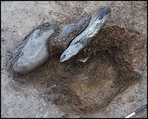
Most of the stoneholes comprised shallow pits (0.80–1.20m in diameter × 0.30–0.50m deep) containing stone packing around an emptied socket. The sockets had subsequently filled with sediment following the removal of each standing stone. The base of each socket bears the imprint of the monolith that once stood in it, preserving each stone's basal shape and size (Figure 5). The largest of these—stonehole 91—has left an unusual pentagonal imprint, while four other stoneholes had rectangular or square imprints (Figure 6).
Stonehole 7, after removal of sediment filling the emptied socket, but with the stone packing still in place (viewed from the east). The packing stones were created from a single boulder, split into pieces before being packed against the side of the monolith. Its imprint in the base of the stonehole reveals that this monolith had a square cross-section (photograph by M. Parker Pearson).

A 3D photogrammetric image of stonehole 91 after excavation of the socket left by the standing stone's removal, viewed from the north. The imprint of this stone (in the right half of the stonehole) reveals that the base of this stone had a pentagonal cross-section. The ramp, along which the stone was erected and removed, is at the top of the picture (photograph by A. Stanford).

Dating the Waun Mawn stone circle
Prehistoric artefacts recovered from Waun Mawn include a flint scraper, a flint chip and a trimmed, circular mudstone disc. Although none of these is closely datable, the disc is of a type found within Neolithic levels at the Carn Goedog megalith quarry, 5km to the east. Prehistoric stone circles are difficult to date, not only because of the paucity of associated material culture, but also because of the lack of materials suitable for radiometric dating from within the stoneholes. This problem is exacerbated by the acidic soils at Waun Mawn, which preclude the survival of antler picks or animal bones. Radiocarbon dating was restricted to samples of wood charcoal recovered by sediment flotation, but their small size (under 4mm long) means that they are likely to have been affected by bioturbation. These samples may, therefore, be either intrusive or residual. To resolve this, radiocarbon dating of these samples from Waun Mawn was conducted in conjunction with optically stimulated luminescence (OSL) dating of sediment from within the packing deposits that were contemporaneous with the monoliths’ erection, and from filled-in sockets (from after the monoliths’ removal). OSL dating determines the burial age of sediments, with the dating signals being reset by light exposure immediately prior to deposition (Smedley Reference Smedley, Smedley and Wintle2018). For sediments that have experienced more complex depositional histories, the true burial age can be obscured by materials that were poorly reset at deposition, or by more recent materials that infiltrate through stratigraphic layers.
OSL dating
OSL dating was carried out on 11 feature profiles, consisting of 195 field- and 162 laboratory-profiling samples, encompassing 18 dating samples. Field profiling proved valuable in interpreting site-formation processes and in establishing the relationship between primary (or ‘constructional’) fills and secondary fills that accumulated following monolith removal. The subsequent programme of laboratory characterisation and screening revealed more complex depositional histories for the socket fills than suggested in the field, indicating a mixing of archaeological materials and substrate in the basal layers, and the infiltration of more recent materials throughout the fills. Notwithstanding this, the stored dose distributions, as obtained from within discrete features, showed good internal stratigraphic coherence, and indicate those parts of the fill that might return Neolithic or Early Bronze depositional ages.
The work then progressed to full quantitative luminescence dating. All 18 samples were characterised by heterogeneous sensitivity and equivalent dose distributions, indicating complex depositional histories. Both low apparent doses (contamination from recent sediments) and high apparent doses (poor bleaching at deposition and/or in situ weathering of the substrate) obscured the archaeologically significant doses. Individual ages fall in the range from 6980±2120 BC to AD 1900±20, the large error reflecting the heterogeneous mixed-age equivalent dose distributions. Samples within the primary fills of the four sampled stoneholes have weighted combinations, suggesting a probable construction date of 3530±330 BC (5.55±0.33 ka). Samples from within the secondary fills, with weighted combinations from two stoneholes, suggest removal of the stones before 2120±520 BC (4.14±0.52 ka). The moment of removal has, of course, left no datable sediments, as these could accumulate only once the monoliths were gone—potentially at any time in the subsequent centuries or even millennia.
Radiocarbon dating
Forty-three samples of wood charcoal were dated at radiocarbon laboratories in Oxford (ORAU) and Glasgow (SUERC; see Table S1 in the online supplementary material (OSM)). Of these, 31 came from stoneholes and the remainder from other features. Many of the dates fall in the ninth to fifth millennia cal BC—broadly the Mesolithic—and these can be excluded as residual in the stonehole fills, as they fall outside the ranges provided by OSL dating. Similarly, those dates that are later than the OSL date range for construction (during the second and first millennia cal BC—the Bronze and Iron Ages) can be excluded as intrusive. That leaves a group of seven dates, four of which are from stoneholes. All of these fall within the latter part of the fourth millennium cal BC—the end of the Early Neolithic and during the Middle Neolithic (Figure 7). As some of these samples could also have been either residual or intrusive, we propose that the stone circle was erected in c. 3600–3000 cal BC.
Radiocarbon determinations of Neolithic and later date from all features at Waun Mawn (dates from the Mesolithic period have been excluded). Note the absence of dates within the third millennium cal BC. All radiocarbon measurements reported here were calibrated using OxCal v.4.2.2 (Bronk Ramsey Reference Bronk Ramsey2009, Reference Bronk Ramsey2020) and the IntCal20 calibration curve (Reimer et al. Reference Reimer2020) (drawn by K. Edinborough).

This date would place Waun Mawn amongst the earliest stone circles in Britain, alongside Long Meg and her Daughters in Cumbria (109m diameter) and the stone circle beneath the passage tomb of Bryn Celli Ddu on Anglesey (18m diameter). Hazel charcoal in one of the stoneholes of Long Meg and her Daughters dates to 3340–3100 cal BC (Archaeological Services, Durham University 2016: 6), and cremated human remains from pits associated with stoneholes at Bryn Celli Ddu date to 3500–3100 and 3310–2900 cal BC (Burrow Reference Burrow2010: 258–61 & tab. 2). Given that no stone circle in Britain dates to before c. 3400 cal BC, we suggest a date in the later part of the OSL date range—c. 3400–3200 cal BC—for Waun Mawn. An end date of 3200 BC for the construction of Waun Mawn is proposed, as this is the limit of the OSL dating. Additionally, the one Neolithic radiocarbon date from a stonehole at Waun Mawn that potentially falls after 3200 BC (3340–3034 cal BC; OxA-38436) is from the fill of emptied stonehole 37, which accumulated after the stone had been removed (Table S1). It may therefore relate to the stone's removal and not its erection.
The geology of the Waun Mawn stones
The four surviving stones at Waun Mawn are of unspotted dolerite, and possibly derive from outcrops 3km to the south-east at Cerrigmarchogion on the Preseli ridge (Bevins et al. Reference Bevins, Ixer and Pearce2014). The only indication of the geology of the monoliths removed from the six other stoneholes was provided by a stone flake left by the standing stone with the pentagonal base (Figure 8). This flake of unspotted dolerite lay on the edge of the ramp, having become detached either during the erection or removal of the monolith. The monolith probably came from the same source on the ridge to the south-east as the unspotted dolerite pillars at both Stonehenge and Waun Mawn.
Left) a flake of unspotted dolerite from stonehole 91 was recovered from the junction of the empty socket and the ramp; top right) stone 62 is one of the three unspotted dolerite pillars at Stonehenge; bottom right) stone 62's basal cross-section matches the imprint of the pillar that once stood in stonehole 91 at Waun Mawn (photographs by S. Laidler & A. Stanford).

Of the three unspotted dolerite bluestones at Stonehenge (stones 44, 45 & 62), stone 62 has a pentagonal cross-section at the turf line. This is similar in shape and dimensions to the imprint in stonehole 91 at Waun Mawn. Potentially, then, stone 62 began its life at Waun Mawn. The un-dressed stones 44–45 in the outer circle of bluestones at Stonehenge are of similar size to the standing stone (2m long) and the stone associated with stonehole 9 (1.20m long) at Waun Mawn, but are smaller than its two recumbent stones (3.20m long). These latter stones are probably slightly longer than stone 62 at Stonehenge, which stands 2m tall above ground. Thus, the dimensions of the Waun Mawn stones compare well with those of the three unspotted dolerite pillars at Stonehenge.
A solstitial alignment at Waun Mawn
Two stoneholes at Waun Mawn had neither packing stones nor ramps. One had formerly held the small, recumbent stone at the east end of the arc—a short monolith 1.20m long, 0.90m wide and 0.25m thick (Figure 9: top). The other stonehole lay 13m to its east, its former monolith now absent (Figure 9: bottom). No cut features were found between the two holes. These two stones had been set with their longer sides perpendicular to the circumference of the circle, rather than parallel with it. As a result, the two monoliths would have formed ‘gunsights’, and we interpret them as forming an entrance on the north-east side of the circle. Viewed from the centre of the circle in the Neolithic period, the midsummer solstice sun rose within this entrance, 2° to the right of the westernmost of the two monoliths (see Figure 4).
Top) recumbent stone 013 lying beside its stonehole (9), viewed from the west. It formed the west side of the stone circle's north-east-facing entrance. Although the top of this pillar (left) is broken off, its weathered surface indicates that this probably occurred long before the Neolithic; bottom) stonehole 21 in half-section, viewed from the east. With its ‘gunsight’ arrangement, perpendicular to the circumference of the stone circle, the removed pillar would once have formed the east side of the north-east-facing entrance (photographs by M. Parker Pearson).

Discussion
At 110m in diameter, Waun Mawn is the third largest of Britain's great stone circles with diameters over 100m: Avebury outer circle (331m; Gillings & Pollard Reference Gillings and Pollard2004), Stanton Drew (113m; Burl Reference Burl1999: fig. 6), Long Meg and her Daughters (109m; Soffe & Clare Reference Soffe and Clare1988), the Ring of Brodgar (104m; Richards Reference Richards2013: 90–118) and the north and south circles at Avebury (104m; Gillings & Pollard Reference Gillings and Pollard2004). By comparison, Stonehenge stage one—the inferred bluestone circle of monoliths that stood within the Aubrey Holes—was 87m in diameter (Parker Pearson et al. Reference Parker Pearson, Pollard, Richards, Thomas, Tilley and Welham2020: 164–69). Unlike that circle, which had its stoneholes spaced at approximately 4.50m apart, Waun Mawn's stones appear to have been spaced more irregularly. Gaps in its perimeter where no stones were ever erected—especially on the north-west side—may be interpreted in two different ways. First, the absence of stones around the circuit may simply indicate non-completion of the monument. Alternatively, the spacing and frequency of stones was strategic in providing enhanced views of the circle when encountered from particular directions, as noted at other stone circles (e.g. Na Dromannan (Calanais X) and the Ring of Brodgar; Richards Reference Richards2013: 114–18 & 251–53). Under these circumstances, the difference in architecture between Waun Mawn and Stonehenge stage one testifies to an altered emphasis and perspective, the latter being one of regularity and homogeneity.
The midsummer solstice sunrise orientation of Waun Mawn's putative entrance provides a parallel with Stonehenge, which is positioned at the south-west end of a geomorphological landform of parallel ridges that coincidentally align on the solstitial axis (Parker Pearson et al. Reference Parker Pearson, Pollard, Richards, Thomas, Tilley and Welham2020: 469–73). In stage one, however, Stonehenge's entrance was also aligned broadly with the northernmost major moonrise—an astronomical event that seems not to have been marked at Waun Mawn (Ruggles Reference Ruggles, Cunliffe and Renfrew1997).
Another link between the two sites is provided by their shared diameters. Stonehenge is enclosed by a circular ditch with a diameter of 110m; Waun Mawn is the only known British Neolithic monument with the same diameter (see Figure 4). The imprint of stonehole 91 at Waun Mawn matches the basal cross-section of stone 62 at Stonehenge, further hinting at a close relationship between the two monuments.
While we believe a strong case can be made for Waun Mawn as the origin of at least part of Stonehenge, it is unlikely that the former circle ever contained as many as 56 standing stones—the number indicated by the Aubrey Holes at Stonehenge. An estimated 80 bluestones are thought to have been brought to Salisbury Plain, the 56 in the Aubrey Holes and around 25 in the nearby circle of Bluestonehenge (Parker Pearson et al. Reference Parker Pearson, Pollard, Richards, Thomas, Tilley and Welham2020: 215–300). During Stonehenge's stage two (beginning in 2740–2505 cal BC), a double arc of stoneholes (the Q & R holes) held an unknown number of bluestones (Atkinson Reference Atkinson1956: 49). In stage three (beginning in 2400–2220 cal BC), the bluestones are thought to have been rearranged into an inner and outer circle using all the extant bluestones as well as those from Bluestonehenge (Parker Pearson et al. Reference Parker Pearson, Pollard, Richards, Thomas, Tilley and Welham2020: 298–300).
The geology of the Waun Mawn stones—all unspotted dolerite, including the flake from stonehole 91—is also at odds with most of the 44 bluestones (43 and the Altar Stone) surviving at Stonehenge today, only three of which are of unspotted dolerite, compared with approximately 27 spotted dolerite stones. That the four unspotted dolerite Waun Mawn stones were left behind may, of course, help to explain why there are so few such pillars at Stonehenge. It seems more likely, however, that Waun Mawn contributed only a small proportion of Stonehenge's 80 or so bluestones. This raises the question of whether multiple monuments in Wales contributed monoliths to Stonehenge and Bluestonehenge. It is clear that the Altar Stone (stone 80 at Stonehenge) comes not from Preseli, but most likely from Devonian sandstone of the Senni Formation, about 100km to the east (Ixer et al. Reference Ixer, Bevins, Turner, Power and Pirie2019). Similarly, the two other sandstone pillars at Stonehenge (Stones 40g & 42c) are of Lower Palaeozoic sandstone, which is found across a large area to the north and east of Preseli (Ixer et al. Reference Ixer, Turner, Molyneux and Bevins2017). Both types of sandstone pillars could derive from circles or other megalithic monuments outside of Preseli. It is possible, if not likely, that one or several stone circles were dismantled in the Preseli area to provide Stonehenge and Bluestonehenge with their full number of bluestones; their varied range of lithologies includes spotted dolerite and various types of rhyolite and volcanics (Ixer & Bevins Reference Ixer and Bevins2011a & Reference Ixer and Bevinsb, Reference Ixer and Bevins2016; Bevins et al. Reference Bevins, Ixer and Pearce2014; Ixer et al. Reference Ixer, Bevins and Gize2015).
Conclusion
Is Waun Mawn the Giants’ Dance described by Geoffrey of Monmouth? Might there be any truth to the legend? Archaeology and myth make awkward companions, and we must reject the details of Geoffrey's story concerning the appropriation of the stones. The shared diameters of Waun Mawn and Stonehenge's enclosing ditch, as well as their midsummer solstice sunrise orientations, suggest that key aspects of the circle's architecture were brought by the people of west Wales to Salisbury Plain, to be both transformed and reinstated, rather than taken by force as a trophy by a Neolithic Merlin and his army.
This interpretation is supported by recent isotopic analysis on 25 of the approximately 60 cremation burials from Stonehenge. Of these 25 individuals, four (16 per cent) have strontium isotope ratios that are consistent with having lived the last decades of their lives on the Ordovician/Silurian rocks of south-west Wales—including around the outcrops of the Preseli Hills (Snoeck et al. Reference Snoeck2018). The remaining 21 individuals have ratios consistent with living on the chalk of Salisbury Plain or on the surrounding Mesozoic strata. If the sample of four out of 25 is taken as representative of the total number of people buried at Stonehenge, we can thus extrapolate that, of the 150–240 estimated burials found there (Pitts Reference Pitts2000: 121; Parker Pearson et al. Reference Parker Pearson, Chamberlain, Jay, Marshall, Pollard, Richards, Thomas, Tilley and Welham2009: 23), 24–38 people could have had such origins. As bone remodels over approximately ten years, causing strontium isotope ratios to alter to the levels found in the new environment (Hedges et al. Reference Hedges, Clement, Thomas and O'Connell2007), any long-distance migrants who had lived more than a decade on the chalk would no longer be identifiable as such. Therefore, the figure of 24–38 could be doubled or even trebled to establish the true total of those who made the journey in their teens or young adulthood, prior to death in their forties.
It is notable that the radiocarbon dates for the four potential incomers from Ordovician/Silurian geology encompass the very beginning of construction at Stonehenge c. 3000 cal BC, when its standing bluestones and cemetery were first established. As these four individuals represent a quarter of the earliest burials, given the estimates above, the number of migrants in this earliest stage could have been anywhere between 25 and 75 per cent of the total cemetery population.
Isotopic analysis of the cremations reveals a chronological pattern entirely consistent with the migration of first-generation settlers, followed by local origins for their descendants living on the chalk and its environs. This pattern of migration to Stonehenge may also have included livestock. Dating to 3350–2920 cal BC, the mandible of an elderly cow found in Stonehenge's enclosing ditch has tooth enamel with a strontium isotope ratio consistent with having been reared in Wales (Evans et al. Reference Evans, Pearson, Madgwick, Sloane and Albarella2019).
The complete absence at Waun Mawn of radiocarbon dates falling within the millennium after 3000 cal BC accords with the scarcity of third-millennium dates from other sites in the Preseli region, despite decades of research into this area's Neolithic (Darvill & Wainwright Reference Darvill, Wainwright, James, John, Murphy and Wainwright2016: 108–14). Equally, Waun Mawn did not become the core of a monument complex of the kind known around other great stone circles, such as the Ring of Brodgar, Avebury and Stonehenge. Its development as a major centre in the earlier Neolithic (see Figure 1) appears to have been curtailed by early dismantling. Although the region was probably not entirely evacuated—the four remaining stones at Waun Mawn possibly symbolise the identities of those groups who remained local—it may have been extensively depopulated. Only further research into settlement and land-use employing other lines of evidence, such as palynology, will provide answers.
In conclusion, it seems that Stonehenge stage one was built—partly or wholly—by Neolithic migrants from Wales, who brought their monument or monuments as a physical manifestation of their ancestral identities to be re-created in similar form on Salisbury Plain—a locale already holding a long tradition of ceremonial gathering (Parker Pearson et al. Reference Parker Pearson, Pollard, Richards, Thomas and Welham2015b: 75–80). Stonehenge's first stage may also have served to unite the people of southern Britain. Bluestones were brought to the land of sarsen stones and installed at a sacred axis mundi (world axis or world centre), where the sky and the earth were envisioned in cosmic harmony, and where people of different cultural and regional origins might gather for collective monument-building and feasting (Gron et al. Reference Gron, Rowley-Conwy, Fernandez-Dominguez, Gröcke, Montgomery, Nowell and Patterson2018; Parker Pearson et al. Reference Parker Pearson, Pollard, Richards, Thomas, Tilley and Welham2020: 469–73).
Previous interpretations of Stonehenge have included its role as a monument of unification that brought the peoples of western and eastern Britain together (Childe Reference Childe1957: 331; Parker Pearson Reference Parker Pearson2013, Reference Parker Pearson, Teather, Topping and Baczkowski2019; Parker Pearson et al. Reference Parker Pearson, Pollard, Richards, Thomas and Welham2015b). This theory draws upon the notion that Stonehenge lay within a ‘neutral’ zone, marked by a north–south line of henges, stone circles and cursuses (elongated parallel-sided enclosures) from the Thames Valley to the south coast of England (Figure 10). This zone broadly forms a geographic divide between different regional traditions in earlier Neolithic material culture, as well as variations in genetic ancestry between east and west (Parker Pearson et al. Reference Parker Pearson2015: fig. 1.11; Pioffet Reference Pioffet2017; Brace et al. Reference Brace2019).
The location of Stonehenge and other monument complexes of the Middle to Late Neolithic (c. 3400–2450 BC) that may have formed a neutral zone or territorial boundary between the west and south-east of Britain (map by I. de Luis).

The evidence for a potential migration accompanying the movement of the bluestones opens a further line of enquiry into explaining Stonehenge's origins and purpose. It raises new questions about why people from west Wales moved themselves, their animals and their sacred stones to Stonehenge. If this was indeed the case, what were the drivers of such a migration? Were they climatic, economic, social or political, or a combination of these? Was there, for example, a social and political vacuum on Salisbury Plain that left its ceremonial complex ripe for take-over? Any such event need not preclude the possibility of both migration and unification.
Acknowledgements
We thank the Barony of Cemaes, Cyfoeth Naturiol Cymru (Natural Resources Wales) and the Pembrokeshire Coast National Park for permission to excavate at Waun Mawn. Geophysical surveys in 2018 were carried out by Jon Milward and Ashely Green (Bournemouth University) and by Philippe De Smedt (Ghent University). Useful comments were received from the two reviewers, enabling our manuscript to be extended and improved.
Funding statement
The excavations and research in 2017 and 2018 were funded by the Gerda Henkel Stiftung (grant numbers: AZ 11/V/17 & AZ 08/V/18), the Rust Family Foundation, the NERC Radiocarbon Panel and Raw-Cut TV.
Supplementary material
To view supplementary material for this article, please visit https://doi.org/10.15184/aqy.2020.239



