In the 1960s and early 1970s, René Millon conceived and directed the Teotihuacan Mapping Project (TMP), an intensive full-coverage surface survey, including small problem-oriented excavations, at the immense ancient city of Teotihuacan, in the highlands of central Mexico, as described in another paper in this issue of Ancient Mesoamerica (Millon and Altschul Reference Millon and Altschul2015). Also in this issue, Ian Robertson (Reference Robertson2015) reports some major findings derived from TMP data. For a recent overall review of Teotihuacan and research on the site, see Cowgill (Reference Cowgill and Stone2007, Reference Cowgill2015).
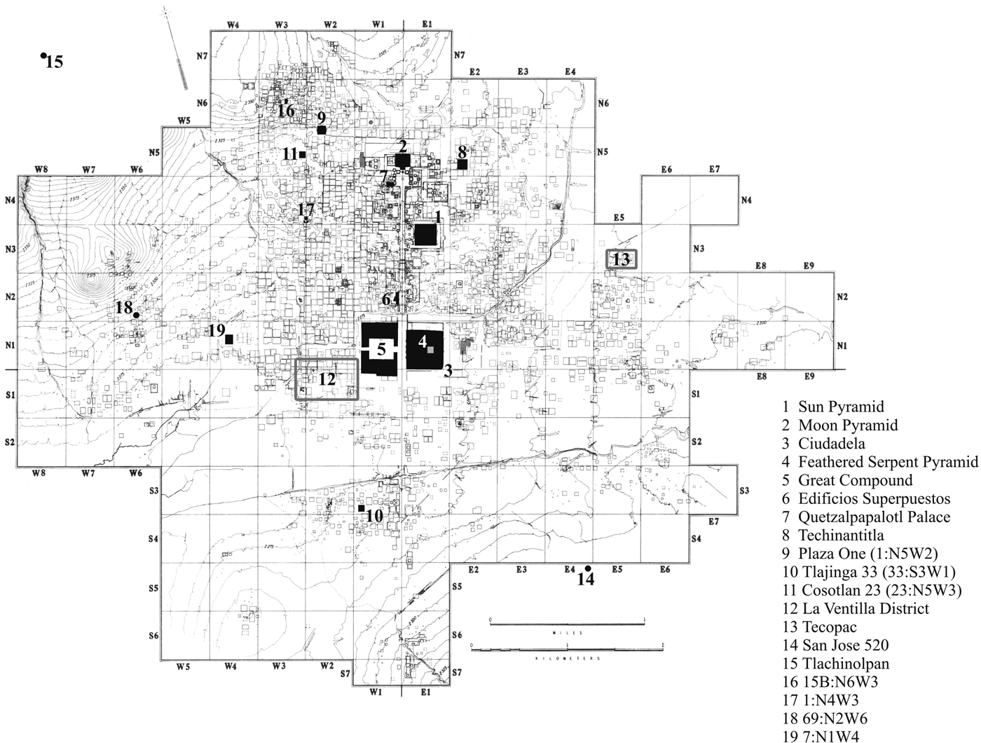
One product of the TMP was an archaeological map in which the city was divided into 500 × 500 m sectors, numbered north-south and east-west from a starting point near the city's center (Figure 1). Sector N3W4 is, for example, the sector that is the third northward and the fourth westward. Structures within a sector are designated by numbers and letters preceding the sector identification; for example, 16:S3E2. This information is essential background for the present paper, and for all other research on Teotihuacan.
Urban Teotihuacan, showing the map created by the TMP and locations mentioned in text. Locational data digitized by Ian Robertson.

In the following pages, I discuss issues of accuracy and validity of TMP data, followed by an examination of challenges associated with the creation of electronic files for these data. I then turn to some broader topics and priorities for further research on Teotihuacan, in some cases taking advantage of the TMP datasets already constructed.
THE TEOTIHUACAN MAPPING PROJECT: ACCURACY AND VALIDITY
By accuracy I mean being correct about what was actually on the ground surface at the time the TMP field work was carried out. By validity I mean drawing correct conclusions about ancient Teotihuacan. There are two major means of assessing accuracy and validity. One is through returning, on the ground, to TMP collection units and making new collections, often subdividing the units into smaller tracts and collecting intensively from each. The collection units defined by the TMP varied in size; the average was around one third of a hectare. Workers walked slowly, two or three meters apart, over all parts of a collection unit, including modern house lots not covered by construction, and with instructions to collect all visible pre-modern rim and other feature sherds larger than about 2–3 cm in diameter. Nevertheless, this resulted in some variation in intensity of collection, mainly because of variations in prevailing vegetation, but also because a few workers were exceptionally zealous, especially in map sectors N1W2, N1E5, and adjoining parts of N2E5 and S1E5. Also, it appears that in a few places the quantity of Aztec ceramics was so great that collection of Aztec materials was more selective. Around 1979, Jeffrey Altschul (Reference Altschul1981, Reference Altschul, McClung de Tapia and Rattray1987) made intensive collections from several TMP collection units, dividing them into 10 × 10 m squares and making separate collections of all sherds larger than 2–3 cm in diameter from each of these squares (rather than just feature sherds). This resulted in roughly 10 to 100 times as many sherds as in the original collections. In 1984, Cowgill directed similarly intensive surface collections from 10 × 10 m squares in TMP units at and near Techinantitla (in Sector N5E2). In 1985, Cowgill and then Brandeis graduate students James Chiarelli and Joseph Lokaj compared proportions of different ceramic categories in the original and the intensive collections. These studies were partially reported in a paper presented at the annual meeting of the Society for American Archaeology (Lokaj et al. Reference Lokaj, Chiarelli and Cowgill1986), but remain unpublished. They suggest that differences in type proportions between the original and the intensive collections were not large enough to significantly affect the spatial patterns seen in distribution maps of sherd densities (collected sherds per hectare) or maps of ratios of one ceramic category to another, based on tracts with denominators large enough to avoid large sampling vagaries.
In 1988, Martin Dudek of Brandeis University directed a similarly intensive collection of 10 × 10 m squares on the surface of the Feathered Serpent Pyramid as part of the project directed by Rubén Cabrera, Saburo Sugiyama, and myself. Only a short time later, Roberto Gallegos, then director of the Teotihuacan Archaeological Zone, made such an investigation impossible by ordering the surface of the pyramid to be paved over. Dudek's work, however, provided a large enough sample to establish that the entire pyramid was completed in a single episode. Most recently, in 2004, Kristin Sullivan, at the time a graduate student at Arizona State University (ASU), made intensive collections from 5 × 5 m squares at Cosotlan 23 (TMP site 23:N5W3), with results discussed in her doctoral dissertation (Sullivan Reference Sullivan2007).
The other means of assessing accuracy and validity is through excavations subsequent to the TMP survey—what I like to call underground truth. I divide these into false positives, false negatives, and “other mistakes.” False positives consist of believing something to be present that, upon excavation, turns out to be absent. False negatives consist of failing to detect something in the surface survey that turns out to be present upon excavation. Other mistakes consist of believing one kind of thing to be present based on surface survey, when excavation reveals something else.
I know of no case where excavations have revealed a false positive. False negatives are also rare or absent in the sense that any surface collection unit that had a reasonable total number of sherds included, upon excavation, sherds from all the phases represented on the surface, and did not contain sherds of any phases not represented on the surface. There have been, however, cases where important remains have been found in excavation of sites where very little or nothing was visible on the surface, usually as a consequence of silting, very heavy surface vegetation, or both. A notable example of a false negative is the unexpected spectacular finds in the 1992–1994 and later excavations in the La Ventilla district (Figure 1), directed by Rubén Cabrera (Cabrera Castro and Gómez Chávez Reference Cabrera Castro, Gómez Chávez, Guadalupe Mastache, Cobean, Cook and Hirth2008), where it had been believed that nothing remained after the landowner had used machinery to flatten low mounds that once existed. Another example is the abundant evidence of a censer ornament workshop in the large walled enclosure attached to the north side of the Ciudadela (2:N1E1) (Múnera Reference Múnera Bermúdez1985), where heavy grass cover and lack of recent cultivation left almost nothing visible on the surface at the time of the TMP survey. It is likely that more such false negatives remain undetected.
Other mistakes include 69:N2W6, interpreted as possibly a round temple, but which, upon excavation, proved to be a rectangular platform. Unit 15B:N6W3 in the Oztoyahualco district was interpreted as a low platform but proved to be a small residential compound (Manzanilla Reference Manzanilla1993). Unit 2:N5E2 and nearby units were interpreted as several multi-apartment residential compounds of average size, but the excavations carried out by Millon in 1984 indicated that this is actually a single compound of exceptional size (Techinantitla) (Millon Reference Millon and Berrin1988a). The TMP survey of unit 33:S3W1 (Tlajinga 33) correctly identified it as a multi-apartment compound and likely workshop for the production of San Martín Orange ware, but missed traces of lapidary working revealed by flotation of excavated materials (Widmer Reference Widmer1991). It is only to be expected that surface survey will not discover evidence that only appears upon flotation, although I note that the TMP survey correctly recognized evidence of lapidary working at units in sector N3E5 (Tecopac), which was confirmed upon excavation (Turner Reference Turner, McClung de Tapia and Rattray1987, Reference Turner and Berlo1992). Cabrera (Reference Cabrera Castro1986, Reference Cabrera Castro, Cabrera Castro, Rodríguez García and Morelos García1991) lists a few more examples of finds not predicted by the TMP survey. This rather short list is greatly outweighed by the much longer list of TMP interpretations verified by subsequent excavations. On the whole, accuracy and validity of the original TMP survey have been shown to be quite high in subsequent excavations. To be sure, surface survey is no substitute for excavations, especially as regards architecture, burials, and caches. But, especially because of the costs of excavation, survey remains an indispensable complement to excavation. It provides critical data that are not feasible to obtain by excavation.
EXPERIENCES IN CREATING ELECTRONIC FILES
The TMP used a standardized form of Site Survey Record (SSR) for recording data in the field (Millon Reference Millon1973:Figure 11). It allowed space for unstructured additional observations and comments. The SSRs were not designed with creation of electronic files in mind, and were not easy to use for that purpose. Therefore, I created a new coding form and code book for creation of an electronic file, with specific data fields (variables). These forms were filled out by coders who had generally not participated in the field survey, relying instead on the SSRs. This worked quite well for code sheet data fields that corresponded closely to the fields in the SSRs. Attempts to have coders do anything useful with topics not explicitly addressed by data fields on the SSRs, however, were generally disastrous. They rarely resulted in anything useful and often led to meaningless and misleading variables that have had to be eliminated from subsequent versions of data files. In other cases, there are gray variables that are not quite useless but must be interpreted with great caution. Metadata discussions of their strengths and limitations are critical and must be heeded.
Data fields for ceramics left much to be desired because of limited categories on the SSR forms, my limited understanding of Teotihuacan ceramics at the time the coding forms were designed, communication problems between myself and James Bennyhoff in designing the original code forms, and between me and Evelyn Rattray in designing the forms for the subsequent ceramic reanalysis.
There are pros and cons for using paper data sheets versus copying directly into an electronic file. The paper sheets add an extra step, yet they provide a hard copy record, and trying to enter data directly into a computer can be cumbersome. Experience with the ceramics from George Brainerd's 1950s excavations at Cerro Portezuelo, recently studied in a National Science Foundation collaborative project directed by myself and Deborah Nichols of Dartmouth College, with the assistance of ASU graduate students Sarah Clayton (Reference Clayton2013) and Destiny Crider (Reference Crider2013), and others from Dartmouth, is that it works best to record data on paper forms, then copy the paper records into an electronic file.
Merging separate TMP records from parts or all of what were originally treated as separate units on two or more SSRs, but which were later judged to be a single meaningful case, was a problem. In a few cases there was not a one-to-one relationship between SSR units and cases in the electronic data file. This was exacerbated by some units (cases) used in the subsequent ceramic reanalyses supervised by Rattray that also did not exactly correspond to cases in the electronic file derived from the SSRs. These problems will be discussed in more detail in a volume in preparation by myself, Ian Robertson, and Rebecca Sload.
Ferreting out errors due to typing mistakes was hard and had to be done partly by hand. Electronic error-detection programs helped, but could not detect all cases.
The original electronic files suffered from several limitations due to 1960s computer technology. There was a premium on short data fields, which inflexibly allowed for no more than two to four characters. They were flat files consisting of variables (columns) and cases (rows), so that the same variables applied to all cases, and all cases were individual collection units rather than a combination of collection units or anything else. Programs for multivariate statistics such as hierarchical clustering, non-metric multidimensional scaling, and principal components analysis could generally handle only a few hundred cases in a reasonable amount of computing time. Since there were over 5,000 collection units in the TMP survey, this meant that multivariate statistical analyses usually had to be based on fairly small subsets of the whole database (see, for example, Cowgill et al. Reference Cowgill, Altschul, Sload and Hietala1984). For simpler analyses, however, the flexibility and speed of FORTRAN programs that I and Brandeis students created often offered advantages over data management systems of the time. To some extent that is still the case with systems for housing data, such as Microsoft Excel and the database program Microsoft Access.
Graphics capabilities were also limited, and this led to partially hand-drawn maps, including contour maps (Cowgill Reference Cowgill and Hammond1974; Cowgill et al. Reference Cowgill, Altschul, Sload and Hietala1984). One disappointment has been the very limited impact of my (Cowgill Reference Cowgill and Hammond1974) adoption of a logarithmic scale for contour maps of sherd densities, as a solution to the problem that some artifact categories had densities ranging from essentially zero to about 12 cases per hectare, while other categories had densities sometimes higher than 400 per hectare. Using different scales for different categories would have impeded comparisons, while a linear scale would have required either an impossible number of contour levels or maps in which all scarce categories were uninformatively lumped into the lowest level. My solution was to use contour levels of 3, 6, 12, 25, 50, 100, 200, and 400 per hectare, which is a logarithmic scale slightly adjusted so that all the numbers are whole numbers. I thought this was a fine idea and I cannot understand why it is not more widely used, unless it is because so many archaeologists are too mathematically challenged to feel comfortable with logarithms. But it is really just making each level twice the previous one.
Of course, for some purposes it is preferable to map densities or other data by individual collection unit, which now can easily be done (see, for example, Robertson Reference Robertson1999, Reference Robertson2001, Reference Robertson, Elena, Gallut and Peralta2005). Still, it is sometimes more enlightening to smooth the data spatially and use contour lines. The two kinds of graphics are complementary. In both cases, it is important to use no more than three to five levels, otherwise the maps become so cluttered that they are hard to comprehend.
Eventually a number of electronic files other than those derived from the TMP SSRs were created. These include REANS2, created by Ian Robertson, based on tabulations by Mary Hopkins and others of the ceramic reanalyses supervised in the 1970s and early 1980s by Evelyn Rattray. The notion of a relational database was proposed as early as 1965 by James Dow (personal communication 1965), but was only implemented by Robertson in the 1990s, in a file called DF9. Robertson also discovered significant amounts of corrupted data that he corrected, and contributed significantly to earlier efforts by Rebecca Sload and Mary Hopkins to add missing data. He also created a digitized version of the TMP map, essentially fully integrated with DF9. A file of metates and manos was derived by Martin Biskowski from paper coding forms for all groundstone artifacts in the TMP collections that I created in 1984, and which were filled out by TMP technicians Pedro Baños and Zeferino Ortega. Nawa Sugiyama has created a file consisting of attributes of a subset of candeleros in the TMP collections, incorporating earlier work on candeleros by Deborah Cembellin. Kim Goldsmith created a paper file of TMP ceramic figurines, and these have been transcribed into an electronic file, mainly by Kristin Sullivan, with assistance from Janet Montoya. Sullivan has also searched the TMP collections for all censer ornaments and recorded them into an electronic file. Margaret Turner created an electronic file of lapidary materials. Except for the ceramic reanalysis file and the digitized map, these other files stand alone. An integrated and fully documented TMP database remains to be created.
It is well to note the existence of various kinds of non-electronic records. These include several filing cabinet drawers of coded data on groundstone not included in Biskowski's electronic file, all the field notes, photos, and other records of TMP excavations, the excavation of Darlena Blucher (Reference Blucher1971) at the Preclassic site of Tlachinolpan (500 b.c.–a.d. 100), and Millon's work at Plaza One in 1958–1959. Originals or photocopies exist in the ASU-managed research center at Teotihuacan, at ASU, and in the possession of René Millon in Rochester, New York. Copies of the Plaza One collection of excavation records also exist at the University at Buffalo, under the supervision of Warren Barbour.
Because of the volatility of electronic records and the frequent obsolescence of database software and hardware, it is critical to establish institutional and financial support for their long-term maintenance and migration to new technology. This is best done as part of an overall program involving an electronic knowledge base and cyberinfrastructure for the Basin of Mexico as a whole.
No matter how well maintained the electronic records are, it is also critical to make and preserve multiple paper copies of original records, especially the 8.5 × 11 inch SSR sheets (some with additional continuation sheets appended) and daily journals of TMP fieldworkers. This is partly because of the amount of significant information in these records that is not captured by any of the electronic files, but it is also essential backup against mishaps in preserving the electronic files themselves. Currently three sets of TMP SSRs and journal records exist: one in the ASU-managed center in Teotihuacan, one at ASU (where they occupy a little less than four filing cabinet drawers), and probably one at SUNY-Buffalo. One of these sets should be scanned and stored in multiple electronic archives. Additional hard copies should also be made.
Future possibilities for analyses based on these files are unlimited. Of highest priority is completing the tasks envisioned in a 1999 NSF proposal by myself, Ian Robertson, and Peter McCartney: revising the documentation of the TMP and ceramic reanalysis data files, getting them in a form suitable for wide Internet dissemination, and writing a co-authored book documenting the files and presenting some major basic results. By 2003 I had completed a draftFootnote 1 of large parts of this book, but it remains incomplete. Some files are available at tDar, with the help of Hannah Reitzel Rivera, under the term “Teotihuacan.” All these diverse files provide, however, only platforms from which further analyses can depart.
It is very unlikely that the maps in Millon et al. (Reference Millon, Drewitt and Cowgill1973) will ever be republished in book form. Robertson and his students, however, have scanned both the field data maps and the archaeological interpretation maps at high resolution, and they are in the process of embedding them in a hyperlinked PDF document (Robertson, personal communication 2010).
SOME LARGE UNANSWERED QUESTIONS ABOUT TEOTIHUACAN
In this section I call attention to some topics of particular interest to me, some of which may not be very fashionable. I merely sketch these topics; my fuller discussions and citations of the literature are published or in press elsewhere. There are many other very worthwhile topics being actively studied at Teotihuacan, such as the nature and significance of small neighborhoods and larger districts, foreign enclaves, craft specializations, and economic practices and institutions, which I do not discuss here.
What Kind of Polity Was Teotihuacan, and How Did It Change Over Time?
Was Teotihuacan (at various times) a monarchy, an oligarchic republic, or what? How well do the “dual processual” strategies described Blanton et al. (Reference Blanton, Feinman, Kowalewski and Peregrine1996) capture the strategies in use at Teotihuacan? How well do Bruce Trigger's (Reference Trigger2003) two types (city-states and territorial states) fit? The Teotihuacan polity was clearly complex, but how was it complex (Nelson Reference Nelson1995)? Are representations of rulers really absent, or have we just not been recognizing them?
Origins
It is quite misleading to think that urbanization in the Basin of Mexico begins with Teotihuacan, given the apparent scale of Late Preclassic Cuicuilco (500–1 b.c.) in the southwestern basin, located about 50 km from Teotihuacan, and the size and number of large pyramids there (Heizer and Bennyhoff Reference Heizer and Bennyhoff1972; Müller Reference Müller1990; Sanders et al. Reference Sanders, Parsons and Santley1979; Siebe Reference Siebe2000). The rise of Cuicuilco seems broadly contemporary with that of large sites in Puebla-Tlaxcala, Monte Albán in the Valley of Oaxaca, and major Late Preclassic sites in the Maya lowlands and highlands. In spite of all the data problems at Cuicuilco, it should be possible to get a much firmer ceramic chronology, unambiguously related to the geological and volcanological evidence. Was Cuicuilco already in serious decline before the early settlement expansion at Teotihuacan in the Patlachique phase (100–1 B.C.), or did the two sites coexist as rivals for a while? Also, we should be able to get better estimates of the population history of Cuicuilco and the evidence for a planned layout there. To what extent did Teotihuacanos build on things already well-developed at Cuicuilco and to what extent were Teotihuacan developments unprecedented (at least in central Mexico)?
What about relations of early Teotihuacan to the large early site of Cholula, located about 95 km southeast of Teotihuacan, and to early sites in the state of Tlaxcala and other nearby parts of Puebla? How big was Cholula, and how early? How closely related to Teotihuacan does early Cholula seem? The same questions apply for sites in other areas adjoining the Basin of Mexico, especially Morelos and the Valley of Toluca.
The Tezoyuca ceramic complex (approximately 200–100 b.c.) remains ill-defined and poorly dated. Does it represent a distinct phase in the local sequence, or newcomers coexisting with peoples making ceramics of the Patlachique phase?
Were there significant external influences and/or migrations in the Basin of Mexico during the Late and Terminal Preclassic periods (roughly 500 b.c.–a.d. 250)?
Was there an overall master plan for Teotihuacan that was gradually constructed over time, as argued by Sugiyama (Reference Sugiyama2005), or was the original layout significantly different from what we see today, as I suspect? Were there significant changes over time in the locations of the most outstanding structures that may reflect significant changes in sociopolitics and/or religion?
Relations with People Not Far Outside the City
It is useful to think of several categories of relations between Teotihuacan and other peoples at varying distances from the city, broadly similar to those proposed by Hirth (Reference Hirth1978), Millon (Reference Millon, Yoffee and Cowgill1988b), and others. These include sites within 10–15 km of the city that are within sight of it and whose occupants could have made frequent trips to the city. Other sites comprise an inner core, which I take to be sites within 15–60 km of the city, mostly within the Basin of Mexico, including Azcapotzalco, Axotlan (near Cuauhtitlan), Cerro Portezuelo, and others. An outer core would include Cholula and other nearby parts of Puebla and Tlaxcala, Morelos, the Valley of Toluca, and the Tula area. How did various sites in the outer core relate to the Teotihuacan polity? For example, at different times was Cholula administered by Teotihuacan, subordinated but not administered, or quite independent?
What sorts of entities are appropriate for thinking on each of these spatial scales? These include the Teotihuacan state, culture, administrators, provinces, allies, outposts, colonies, presences, and influences.
Relations Afar
This topic includes pretty much the rest of Mesoamerica. Was there ever a Teotihuacan empire? If so, when, where, and for how long? And, if an empire existed, was it based on territorial control or only a few strategic outposts? Varied kinds of Teotihuacan presences occur in parts of western Mexico within about 200 km of the city (but probably not much farther); at Matacapan in southern Veracruz; Maya lowland sites such as Tikal, Uaxactun, Copan, Altun Ha, and Caracol; at Mirador and Cerro Bernal in Chiapas; at Kaminaljuyu; and in Pacific piedmont sites in Guatemala. To what extent do various kinds of presences in various places represent direct action by the state, merchants, or others acting somewhat independently of the state, or even dissident emigrés? What was the role and nature of Teotihuacano warfare, in tactics, technology, training, resources, and ideology? How did it change over time? What presences are due mainly to emulation by local elites, using the prestige of Teotihuacan for their own purposes?
Possible Insignia of Rank
Clara Millon (Reference Millon1973) made a case for the tassel headdress as an important symbol, but I do not think much has been done with this topic since then. I have worked on different kinds of nose pendants as possible insignia of rank. Commoner households probably existed on a continuum of wealth, but government offices, especially military offices, were probably standardized and ranked. More work along these lines would likely be profitable.
Decline of the Teotihuacan State and Destruction of the City
Did central Mexican Epiclassic period (a.d. 600–900) centers such as Xochicalco, Cacaxtla-Xochitecatl, and Cantona develop early enough to reduce Teotihuacan's access to resources previously available to the city, and hence contribute to the collapse of the Teotihuacan state, or did these centers only become important after the Teotihuacan state was already in serious decline for other reasons? Was Epiclassic Tula Chico larger than has been thought, and powerful enough to have played a role in Teotihuacan's decline? We urgently need better chronologies, both absolute dates based on high-quality radiocarbon specimens from good contexts, to which Bayesian methods are increasingly being applied, possibly other methods, and finer-grained relative sequences of ceramics and other kinds of materials.
Within the city itself, what of the role of lesser elites? Were they increasingly independent of central authority and increasingly a source of trouble for it? Were there increasing gaps between rich and poor?
What was the degree of cultural and ethnic continuity after the fiery destruction of the city, at the city itself and in the Basin of Mexico in general? We need better evidence (cultural, linguistic, osteological, chemical, and genetic) for and against significant migrations or even invasions from outside central Mexico.
Although climatic changes and serious human-caused environmental damage seem unlikely explanations for the collapse of Teotihuacan, more evidence about them is desirable (McClung Reference McClung de Tapia2009).
SOME SUGGESTED HIGH PRIORITY FIELD PROJECTS
Cosotlan 23
Site 23:N5W3 was a residential workshop that produced figurines, censer adornos, and possibly other things. Exceptionally rich surface materials span the Patlachique to Aztec occupations (approximately 100 b.c.–a.d. 1600). As noted earlier, very detailed surface mapping and collections from 5 × 5 m squares were made here by Kristin Sullivan, who hopes to follow up with excavations. Teotihuacan still suffers from the lack of an areally extensive excavation of a residential site, with serious attention to truly fine-grained stratigraphy and ceramic chronology, and this place seems ideal for that purpose. The large amount of post-Teotihuacan sherd cover suggests that Teotihuacan structures are probably little-disturbed, and also offers an opportunity to explore the Teotihuacan-Epiclassic transition (a.d. 600–650). Will there be evidence of an abandonment interval, or what? One could go far beyond previous work in residential compounds in pinning down just what was being done where by the occupants, over time, both as to workshop activities and as to other things. There is a chance that remains of Patlachique and/or Tzacualli phase (a.d. 1–150) structures might survive at Cosotlan 23. This would be an ambitious, costly, long-term project. The site lies outside the well-protected archaeological zone.
Plaza One
Site 1:N5W2 is a major three-pyramid complex (a triadic group), far from the Avenue of the Dead. Both Carmen Cook de Leonard and René Millon excavated here in the 1950s and each published several articles about it (Cook de Leonard Reference Cook de Leonard1957; Millon Reference Millon1960; Millon and Bennyhoff Reference Millon and Bennyhoff1961). The complex was something special at least as early as the Tzacualli phase, and perhaps the Patlachique phase. Construction episodes, possibly intermittent, continued into the Postclassic period (a.d. 900–1500). It is one of only six to eight large triadic groups outside the civic-ceremonial center of the city. These groups are too few and too large to be plausible neighborhood (barrio) centers, and they are all located in the oldest part of the city—the northwest quadrant. Their role remains enigmatic, though they probably represent some sort of intermediate entities between the topmost elites and commoners. As of a few years ago, little seems to have changed at Plaza One since the 1950s, and a great deal of it remains unexcavated. It is a strategic spot for learning about early civic-ceremonial structures at Teotihuacan, especially those not associated with the later civic-ceremonial core, and their changing uses over time. Millon's field data and collections are housed in the University at Buffalo, where Warren Barbour and his students are analyzing them and seeking funds for further Plaza One excavations.
Techinantitla
In TMP sector N5E2, Techinantitla is the site of many looted murals, many published in the volume Feathered Serpents and Flowering Trees (Berrin Reference Berrin1988). Millon excavated briefly here in 1984, with limited resources and on a small scale. Many questions remain unanswered, but it seems this site is an apartment compound of exceptional size. More work here should have a large payoff in terms of knowledge. Besides the virtual certainty of finding more murals, the overall layout could be firmly established. Also, much can be learned about abandonment processes and the transition to the Epiclassic. Hints that the proportion of exceptionally fine ceramics is unusually high here can be tested. What sort of people lived here, and where did they fit in the Teotihuacan sociopolitical system? Can we confirm a special connection with the military? A richer corpus of murals will at least improve our understanding of Teotihuacan symbolism, and, since many glyphs are present, could lead to breakthroughs providing clues as to the dominant language of Teotihuacan, at least in its later phases.
Structures on the North Platform of the Great Compound
The Great Compound sits on the west side of the Avenue of the Dead, across from the Ciudadela. It is a huge 20 ha structure, consisting of two low platforms that enclose a plaza covering a little more than 5 ha. This plaza may have been the principal marketplace of the city, although more evidence is needed to confirm this. The South Platform is so altered that excavations there may not be fruitful, but much of the North Platform is still fairly intact, with unexcavated low mounds that indicate the presence of structures. It is very unlikely that these are simple residences. Were the structures on it storage facilities for the state, offices of middle-level bureaucrats, or what?
Earliest Stages of Structures along the Avenue of the Dead
The fronts of most structures along the Avenue of the Dead, in the segment between the Ciudadela and the Moon Pyramid, have been reconstructed by the Instituto Nacional de Antropología e Historia (INAH), generally based on the latest well-preserved construction stage. In a few cases earlier stages have also been excavated (for example, the Quetzalpapalotl Palace and Edificios Superpuestos), though not with modern techniques of data recovery. Except for a recent tunnel in a pyramid near the northwest corner of the Moon Plaza, made as part of Sugiyama and Cabrera's Moon Pyramid Project, I know of no effort to get at the earliest stages of these structures—either to get their layouts and construction features or to date them by ceramics and possibly other methods. A sample of these structures should be tested to get evidence about questions such as: (1) how early was the Avenue of the Dead laid out, and (2) what did it look like in early times? It is clear that major additions were made over time, so the early Avenue may not have looked much like the one we see today. At the Ciudadela, excavations reveal pre-Ciudadela structures quite different from the Ciudadela itself. Were there comparable early differences anywhere else along the Avenue?
Insubstantial Structures
The TMP found a number of places within the city with significant amounts of Teotihuacan period (100 b.c.–a.d. 650) ceramics on the surface but no traces of building materials. It is very unlikely that they were sites of the architecturally substantial multi-apartment residential compounds that housed most of the city's occupants. From surface evidence alone it is unclear if they were the sites of insubstantial structures or other kinds of open spaces. Robertson (Reference Robertson2008) has begun testing some through excavation, finding cases where Teotihuacan period insubstantial structures did exist within the city. At site San José 520, Oralia Cabrera Cortés (Reference Cabrera Cortés2006, Reference Cabrera Cortés2011) has excavated insubstantial structures occupied by potters on the outermost edge of the city. For the first time, we have excavation data on what were likely the lowest socioeconomic levels of Teotihuacan society. Work on such structures should continue, as a necessary complement to work on the great temples and on structures representing a wide range (probably a continuum) of intermediate socioeconomic levels.
A Possible Epiclassic Civic-Ceremonial Structure at 1:N4W3
This is a pyramid of modest size, with substantial Coyotlatelco period (a.d. 650–850) and later sherd cover, in a region where Coyotlatelco sherd cover is generally substantial. Given the large extent of Coyotlatelco-style sherd cover at Teotihuacan, I find it hard to believe that there were no Epiclassic civic-ceremonial structures there. I suspect they have been damaged by later events, or even simply overlooked by archaeologists intent on removing the post-Teotihuacan overburden in order to get at the Teotihuacan materials. This site may be the best bet to test the possibility of an Epiclassic temple. Within a botanic garden, it seems relatively safe from disturbance at present, its excavation should not be delayed too long.
An Aztec Palace?
TMP site 7:N1W4 was an open field in San Juan Teotihuacan just southwest of where a Mormon church is presently located. On the surface it was exceptionally rich in Aztec ceramics. It was surely an important Aztec site, and it may have been the palace of the tlatoani of the Teotihuacan altepetl. The owner was extremely resistant to any further archaeological work here. By 2011, most of it was covered by recent buildings, but a possibility of some salvage work remains.
SUGGESTED NON-FIELD PROJECTS
Seriation of Grave Lots as a Test and Improvement of Ceramic Chronology
There are significant problems and limitations with current ceramic chronologies for Teotihuacan, and they must not be accepted unquestioningly. About 115 years after the work of Sir Flinders Petrie in Egypt, it does not seem premature or too rash to consider applying grave-lot seriation at Teotihuacan. At a minimum, this would be a welcome confirmation of the present ceramic chronology, and it is quite likely that such an effort would considerably refine the chronology, and perhaps reveal significant errors in need of correction. Time resolution on the order of much less than a century will be very hard to obtain by radiocarbon or other such methods. Tedious and unfashionable as it may seem, better ceramic and lithic chronological resolution is critical for resolving all the fashionable questions about Teotihuacan and Mesoamerica in general. This is probably not a good dissertation topic; it should be undertaken by an already-established scholar willing and able to spend years on a project whose results will be indispensable, but which will never make prime time. Using graves and caches to seriate direct-rim tripod cylinder vases may be especially useful, since they were one of Teotihuacan's few ceramic exports, and thus have a potential for cross-dating.
Mining and Preserving the TMP Electronic Files
Research based on the TMP electronic files has only scratched the surface of their possibilities. Any number of new projects are possible—many that we have not yet imagined. In order to make such projects possible, it is critical to maintain the institutional and technological support to preserve these files and their accompanying documentation, in ways that make them readily accessible to potential users.
Mining and Preserving the TMP Collections
Far more research is possible with the actual TMP collections, housed in the ASU-managed archaeological research center in Teotihuacan. Numerous studies since the conclusion of TMP fieldwork have amply demonstrated that, useful as the electronic files and paper records are, there are innumerable significant questions that can only be answered by re-examining the actual objects. It would be an irreparable disaster if these collections, and their accompanying documentation, were to become unavailable for study. This is both a warning and an invitation for researchers to make use of these materials. It is also a reminder that all collections stored at the ASU-managed facility need fuller documentation and more attention to their continued upkeep, especially collections deposited by users of the facility other than the TMP.
CONCLUSION
I hope that our experiences in creating the TMP data files will be useful to others, even at this late stage in the production of electronic databases. I also hope that my outline of the contents of TMP files will be informative. I have sketched some research topics that I think should be pursued, both fashionable and unfashionable, and I have pinpointed a few of the myriad of places within the city that should be more fully excavated while it is still possible.
RESUMEN
En este artículo resumo algunos de los logros del Teotihuacan Mapping Project (TMP), proyecto llevado a cabo en el Valle de Teotihuacan y dirigido por René Millon durante los años sesentas y setentas. Inicialmente abordo aspectos relacionados con la exactitud (siendo correcto acerca de lo que se existió en la superficie en el momento de la prospección) y la validez (sacando las conclusiones correctas acerca de Teotihuacan). Las excavaciones subsecuentes han revelado unos cuantos errores del TMP, pero éstos son superados por las mucho más numerosas interpretaciones correctas. Discuto algunos de los problemas que surgieron durante la creación de los archivos electrónicos, incluyendo la importancia de mantener siempre los registros tanto en papel, como en archivos electrónicos, y hago una lista de los archivos que se han creado. Posteriormente, me enfoco en las cuestiones acerca de Teotihuacan que me interesan de manera especial, incluyendo que tanto se aplican los conceptos de estrategias corporativas y de red; Cuicuilco y los orígenes de Teotihuacan; las relaciones con otros asentamientos dentro del área nuclear de la ciudad; las relaciones con otras partes más distantes en Mesoamérica; posibles insignias de rango; y las razones que llevaron al declive y caída del estado Teotihuacano. Concluyo con algunas sugerencias de proyectos de campo que considero tienen alta prioridad, así como de investigaciones basadas en colecciones de materiales y archivos electrónicos.
ACKNOWLEDGMENTS
I am grateful to Oralia Cabrera for translation of the Spanish resumen, and to Ian Robertson for creation of Figure 1. Richard Blanton and Susan Evans made thoughtful comments on an earlier draft, but only I am responsible for the final version.