BEDFORDSHIRE
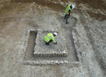
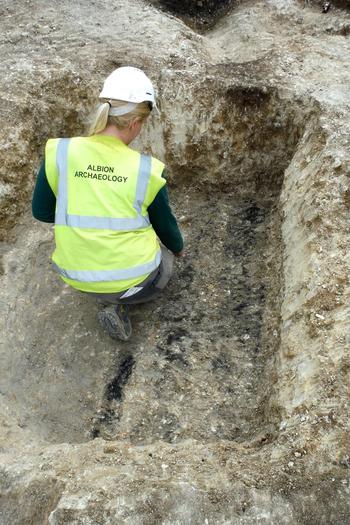
(1) Houghton Regis, North 1: Project HRN3205 (TL 0387 2422): excavation over 1.45 ha uncovered a late Iron Age/Roman trackway with an adjacent linear cremation cemetery and two crop-processing areas. Eleven of the burials were unurned and three urned. The latter contained a small number of grave goods, including accessory pottery vessels (two) and fragments of two brooches. The crop-processing areas were c. 65 m apart and contained single drying-ovens. One of the ovens had a lining of chalk and flint nodules; it was square in plan with a flue extending from one corner (fig. 14). The lining of the other oven had been largely robbed but the surviving elements suggest that it was of the T-shaped type. Charred plant remains from both ovens indicate that they were used for the drying and parching of hulled wheat, with no substantive botanical evidence for malting. Adjacent to the T-shaped oven was a steep-sided, flat-bottomed, rectangular pit with charred planks on its base and post-holes in its corners which may have supported boarded sides (fig. 15). The identification of storage pits on Roman sites is relatively uncommon but a comparable pit, also with evidence of timber structure within it, was found at Cams Hill School, Fareham, Hants.Footnote 43 A curvilinear arrangement of gullies appeared to enclose the oven and pit, although it was not obviously structural in nature. The nearest known settlement is located c. 100 m to the south.
Houghton Regis. Square drying-oven with a lining of chalk and flint nodules.

Houghton Regis. Charred planks just visible on the base of the possible storage pit.

(2) Multi-parish, M1 to A6 Link Road (TL 04225 26031–TL 07836 27078): evaluation identified Roman remains along the length of the route, in parts corresponding with the results of the geophysical survey. Field 2 contained a concentration of pits and ditches dating to the late Iron Age and early Roman periods with finds of pottery, kiln furniture, animal bone and hammerscale indicating industrial activity in this location. Field 4 contained a cobbled trackway and associated roadside ditch that produced a large amount of mid-Roman pottery. A large number of ditches were encountered across Field 6, with associated pottery dating from the middle Iron Age through to the late Roman period. Of note from this location was a large pit containing several high-status cremation vessels and cremated human remains. Field 9 towards the eastern end of the link route contained pits, ditches and two possible wells dating from the middle Iron Age through to the early Roman period.Footnote 44
CAMBRIDGESHIRE
(1) Wimpole, Wimpole Hall carpark (TL 53421 25061): excavation uncovered the remains of an intensively occupied late Iron Age to Roman pastoral settlement, dated approximately 100 b.c.–a.d. 150, with at least four distinct phases of occupation and use, including possible ritual connections and small-scale industry. The archaeological remains included several large stock enclosures, two roundhouses (one with its central hearth still surviving), a large watering hole and a metalled surface.
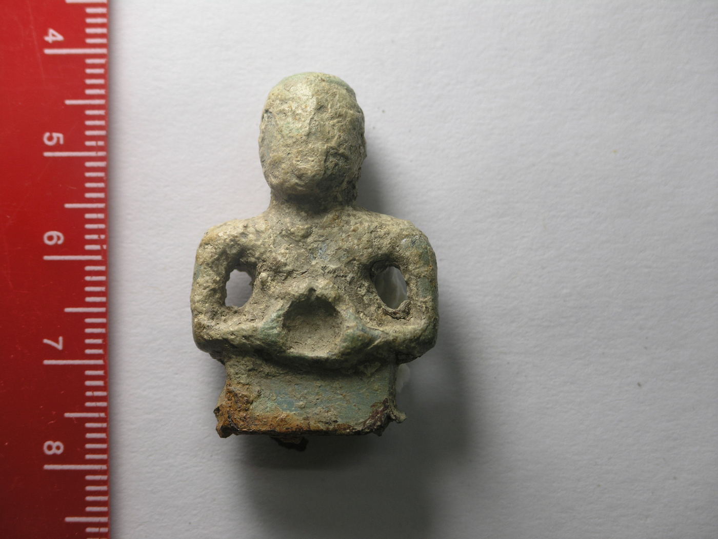
In addition to large assemblages of ceramics and faunal remains, approximately 300 items of copper alloy and iron were recovered. These finds included Roman toiletry sets, keys, items of personal adornment and coins, the majority with a distinct date range of 50 b.c.–a.d. 65, suggesting communication and exchange between the Iron Age inhabitants of the settlement and the Roman newcomers. However, a small purse hoard, totalling seven early fourth-century coins, was also recovered, suggesting later, limited use of the site. The most important of the finds comprised a small, copper-alloy, second-century a.d. spatula handle, believed to depict the enigmatic Gaulish deity of wild things, Cernunnos, identified by his holding of a torque (fig. 16). This is the only known example of Cernunnos depicted in this form. Some of the metalwork recovered suggests a connection with the burgeoning early Roman military population. Items such as a spear head, an arrow head, various military buckles and armillae and a small piece of lorica segmentata can all be comfortably dated to this early period. Their presence may be explained by the location of the site, being situated neatly between the known Roman roads Ermine Street and Akeman Street. The site was still cultivated during the early years of the second century a.d., evidenced by various recuts of ditches. However, its status as a focus in the landscape, whether of trade or ritual, was in rapid decline.Footnote 45
Wimpole. A copper-alloy spatula handle, believed to date from the second century and to depict the Gaulish deity Cernunnos.

LEICESTERSHIRE
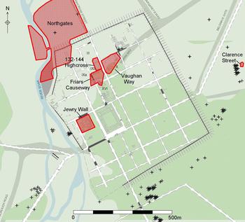
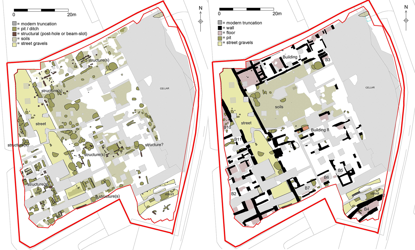
(1) Leicester, Friars Causeway/Highcross Street (SK 5826 0473): the largest excavation in Leicester for over a decade was undertaken on the site of the former factories of ‘Stibbe’ (fig. 17), following an earlier evaluation in 2001.Footnote 46 The site encompassed parts of three insulae (IXa, IXb and XVI), defined by one north–south street, 55 m in length, and one east–west street (fig. 18). Activity predating the street-grid comprised mid-first-century timber buildings. Further pits and boundary ditches were set further back from the roads, pointing to a bustling and intensely occupied part of the town in the late first and early second centuries. Evidence for a number of small roadside masonry structures was also discovered, along with three large Roman town-houses. One town-house was located on the eastern side of the insula that fronted onto the north–south street separating Insulae IXb and X. This may be the town-house that contained the ‘Cyparissus mosaic’,Footnote 47 discovered in the seventeenth century and described in 1804 as being in this location. Another town-house located on the east side of Insula IXa was perhaps a courtyard-style structure, but its plan had been heavily truncated by nineteenth-century factories.
Roman Leicester. ULAS sites mentioned in the text.

Leicester, Friars Causeway Roman-period features — early Roman (left) and late Roman (right).

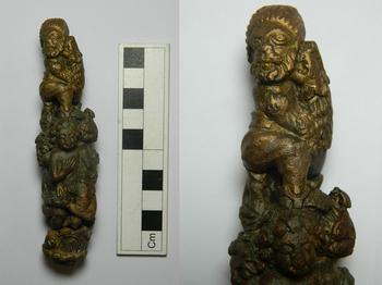
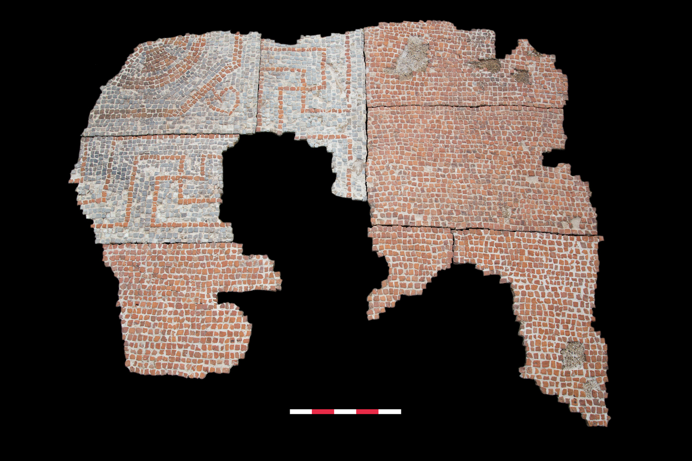
The finest preserved Roman structural evidence lay on the north edge of the site (and in the northern half of Insula IXb) and was represented by the southern wing of a large, possible courtyard-style, town-house (reminiscent of earlier discoveries at Vine Street, LeicesterFootnote 48) which contained tessellated pavements and mosaics in every room (the building continued northwards beyond the limit of this excavation). The best-preserved of these, at the east end, in a room with a channelled hypocaust, was an outstanding mosaic, being the largest and finest-quality example to be uncovered in Leicester in over 150 years (fig. 19). Decorated with complex geometric patterns, this floor had been cut by medieval pits and a 1950s cellar, but enough survived to see that it was sited within a room 10 m in length and 6 m wide. Its intricate design included a border composed of four intertwined strands (guilloche), surrounding shield (peltae) and Greek key (meander) patterns. It also contained octagonal panels depicting a variety of scenes. The quality and workmanship are comparable to the Blackfriars and Peacock pavements that were found in Leicester during the nineteenth century. This impressive mosaic was perhaps in the main reception room of the house, covering the channelled hypocaust system that provided underfloor heating. As part of the project the mosaic was lifted and conserved for future display. A key handle was recovered from between two floor surfaces in the town-house (fig. 20). Cast in copper alloy this ornately decorated artefact is of an exceptionally high standard. The main element shows a male figure with details of his face strikingly well-preserved. He is shown under attack from a male lion, who clings to the individual’s waist. The man and beast stand on the heads of four naked, curly-haired men. This object may represent a damnatio ad bestias scene (this will be reported fully in a future volume of Britannia).
Leicester, Friars Causeway mosaic.

Leicester, Friars Causeway key handle.

Two large curving walls were found on the northern edge of Insula XVI (the southern side of the excavation). These were clearly part of a substantial structure, almost certainly a Roman public building, probably a theatre, with foundations almost 2 m deep and superstructure surviving to over 1.5 m in height.Footnote 49
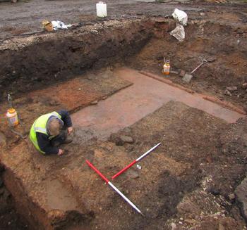
(2) Leicester, 132–144 Highcross Street (SK 58189 04445): evaluation by trial-trenching revealed evidence for activity in part of Insulae III and IXb, consisting of a Roman street, along with at least two large Roman buildings (fig. 17). The building in the southern edge of Insula III contained two rooms with remarkably well-preserved opus signinum floors and painted quarter-round mortar mouldings at the wall/floor junction (fig. 21). Another Roman building within the northern edge of Insula IXb (the same insula as the Stibbe excavations) contained a sunken-floored room, perhaps evidence for a hypocaust.
Leicester, 132–144 Highcross Street; building in Insula III with well-preserved opus signinum floors and painted quarter-round mortar mouldings.

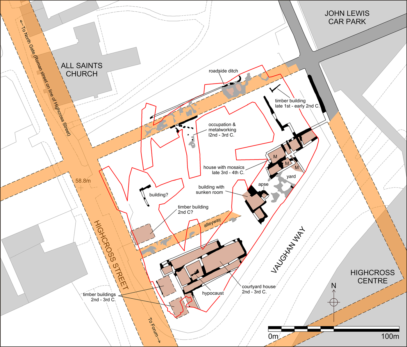
(3) Leicester, Vaughan Way/Highcross Street (SK 5832 0480): excavation immediately to the east of the Friars Causeway excavation (fig. 17) revealed evidence for nearly two-thirds of Insula X, containing a Roman street and structures of the second to fourth century (fig. 22). On the western side of the insula a large Roman town-house was uncovered; two ranges of rooms flanked by a corridor or portico appeared to surround a courtyard. At least one room had a hypocaust. It is likely that this was a large town-house reminiscent of the nearby Stibbe town-houses (see above). North of this building, running east to west was a cambered gravel street, with yards and some timber buildings with evidence for copper-working. On the eastern side of the insula, remains of a second Roman house were identified including fragmentary outlines of several rooms. Evidence for mosaic floors was recovered in three rooms, the largest surviving mosaic fragments measuring 2 m by 3 m (fig. 23). This mosaic had a thick border of large red tiles surrounding a central square of grey tiles, with several decorations including a geometric border, foliage and a central hexafoil, and most likely dates to the early fourth century. As part of the project the mosaic was lifted and conserved for future display. A third small Roman building was found in the centre of the site; it had a large sunken room or cellar which appears to have incorporated a small apse to one side. The building has no obvious purpose but could be the remains of a large hypocaust. It seems to have been tucked away in yards and gardens in the middle of the insula, giving it privacy away from the surrounding streets; the possible apse is very small and could have held a statue, possibly making it a shrine or ornamental garden feature.Footnote 50
Leicester, Vaughan Way site plan.

Leicester, Vaughan Way mosaic.

NORTHAMPTONSHIRE
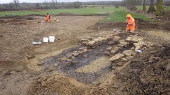
(1) Harpole, (SP 6825 5963): five excavation areas and an area of watching-brief were uncovered in advance of construction of a business park adjacent to Junction 16 of the M1 motorway. A pit alignment was established during the middle Iron Age and appears to have remained open into the late Iron Age/early Roman period, when it formed the western boundary of a ditched field-system. During the second century a.d. the landscape was reorganised, presumably as part of the agricultural land surrounding a villa that is situated immediately to the north of the site. A complex of rectilinear and curvilinear enclosures was established close to the villa, slighting the earlier field-system, and new fields were laid out on the opposite side of the outwash channel of a spring. Of particular significance were a rectangular, stone-founded building beside the channel, which may be a shrine or mausoleum, and an area dedicated to crop processing. The latter area comprised four corn-drying ovens (fig. 24), a threshing-floor and three stone-lined tanks that may have been used for steeping grain as part of the malting process, providing evidence for the production of beer. This arrangement persisted until the end of the Roman period, one of the latest elements being the addition of an aisled building.Footnote 51
Harpole, view of a late Roman corn-drier.

OXFORDSHIRE
(1) Dorchester on Thames, allotments (SP 5773 9410): the final season of the training excavation run by the Dorchester Project team in the allotments overlying the south-west quarter of the Roman settlement continued the investigation of the same 30 m by 20 m area as in previous years, with the main north–south Roman road through the settlement at its eastern margin. A previously identified roughly west–east-aligned ditch of late Iron Age/early Roman date was examined further in the western part of the site, and a possible northward return of this feature was located in the centre of the site, the area between being truncated by later pits (see below).
In the eastern part of the site, evidence for the early Roman fort identified by Frere in excavations in 1963 was found beneath the road.Footnote 52 This consisted of east–west and north–south wall slots of timber buildings, apparently of more than one phase, some indicated by voids marking the presence of decayed timber uprights. These features, almost certainly of military character, lay within an area only c. 12 m by 8 m, so interpretation of the structures represented is very difficult. Associated finds were very few. Objects potentially related to this phase, but not necessarily directly associated, included a fired clay sling bullet, a Claudian copy as, two Hod Hill type brooches, a possible strap-fitting and a fine copper-alloy mount with a head of Silenus. The relationship of the military features to slightly later north–south linear features at the western margin of the road remains to be clarified.
A small shallow pit in the south-west corner of the site was of Flavian date. The central part of the site was almost completely occupied by a north–south zone of pits, some partly examined previously. These were very substantial, typically up to 1.8–2 m deep with very steep-sided profiles, and were probably dug originally as quarries for gravel and brickearth. In view of their size they could only be sampled. The largest pit (feature 4004, roughly 8 m by 6 m) lay in the south part of the central zone of the site and was almost completely excavated. Its lower fills were not particularly finds-rich, but one produced a fresh coin of Hadrian dated a.d. 134–138, while the middle part of the fill sequence produced substantial quantities of finds of second-century date. Infilling was not completed until the late Roman period. Pits to the north, set back from the road edge and probably dug in the later first century, also certainly had fill sequences that continued into the second century, while further pits between and just to the east of these features and pit 4004, approaching the edge of the roadside zone, were probably later in date. This suggests that access from the road towards features further west, including a large, previously excavated, second-century and later building, probably set within a ditched enclosure at the western margin of the site, was not straightforward. Gravel surfaces of the middle Roman period overlay the northern pit cluster and extended westwards up to the front of the building but were completely absent in the southern half of the site, where feature 4004 seems to have remained partly open. The space west of 4004, between it and the building and its associated enclosure ditch, does not seem to have been intensively used in the middle Roman period. Late Roman features have been described previously.Footnote 53
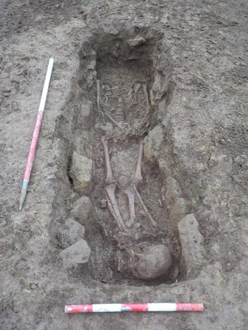
(2) Hook Norton, Sibford Road (SP 3564 3383): an evaluation and subsequent 1.7 ha excavation uncovered an area of Roman settlement. The earlier phase comprised a ditched trackway adjoined by a sequence of boundaries that were reorganised and rearranged recurrently during the first and early second century, as well as the remains of a neonate buried in a ditch and a cremation burial of an adult. This was superseded by domestic occupation that continued until at least the late third century and included at least two rectangular stone-founded buildings, cobbled yard surfaces, a corn-drying oven and seven burials. The burials exhibited a surprisingly large range of funerary practices, despite their small number, including two prone burials and two individuals who had been decapitated and the heads placed near the legs (fig. 25), the latter two being buried in graves with stone linings. Evidence from charred plant remains and animal bones indicated that the settlement was primarily engaged in farming, growing spelt wheat and maintaining herds of cattle and sheep, with a much smaller number of pigs and horses. The investigations provide the first excavated evidence for Roman occupation at Hook Norton, where it has long been suspected that a settlement of some sort was present due to antiquarian reports of finds of coins and burials.Footnote 54
Hook Norton, decapitated inhumation with the skull placed by the feet within a stone-lined grave.

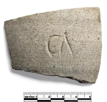
(3) Northmoor, Moreton Lane (SP 41728 02493): a small excavation was carried out within a Scheduled Monument comprising an extensive area of cropmarks thought to be principally of Iron Age and Roman date. Watching-briefs had previously been undertaken close to the site in 1995 and 2007 in advance of construction of agricultural buildings. The excavation uncovered ditches of mid to late Roman date that defined the boundaries of rectilinear enclosures which abutted a trackway to the west, part of which had been uncovered by the 2007 watching-brief. There was no definite evidence regarding the function of the enclosures, but it is evident from the artefactual assemblage that domestic occupation lay somewhere nearby. Finds included a sherd with a graffito possibly reading ‘CA’ (fig. 26).Footnote 55
Sherd of pottery with graffito ‘CA’ from an early fourth-century ditch.

(4) South Leigh, Gill Mill New Quarry (SP 372 081): at the north-west end of the quarry, excavation in Area 3, evaluated in 2017, covered some 7.25 ha. The principal settlement focus of roughly 4 ha (centred on SP 3655 0840), as located by a previous geophysical survey, was continuously occupied from the middle Iron Age up to the early Roman period. The overall axis of the settlement was broadly north-west to south-east parallel to the line of the river Windrush to the west.
A trend towards the laying out of more rectilinear enclosures but referencing the earlier features may have started in the later Iron Age. A third and final phase of boundary features, of broadly mid to late first century a.d. date, formed fairly regular rectilinear enclosures, but the ditches were mostly quite slight. These features concentrated towards the eastern side of the main settlement focus — and some of the latest features, including a roughly east–west-aligned trackway, lay still further south-east. Two small rectangular enclosures, less closely linked to features of the main settlement focus, lay just to the west of it and were probably also of early Roman date. Two probable ‘stack ring’ gullies were also located in this area, while a small number of four-post structures were scattered across the occupied area. A shallow stone-lined well lay towards the southern margin of the settlement. The relationship of structures to the sequence of ditches has yet to be resolved, but at least 20 penannular gullies, most if not all probably defining roundhouses, were identified. The number in use at any one time is not yet known; most may belong to the earlier phases of occupation.
The agricultural economy is likely to have been focused on pastoralism, with rearing of both sheep and cattle important. Finds assemblages were mostly unremarkable, but the early Roman pottery included significantly more South Gaulish samian than would normally be expected in a lower status rural settlement in this region, and a single sherd of Lyons ‘Italian type’ sigillata, probably of Augustan date, is a most unusual find for a site of this type.
The majority of occupation may have ceased by about a.d. 100, and no Roman features were certainly dated after about a.d. 120. A few small quarry pits in the north-eastern part of the site were of medieval date. Medieval (and probably also later) plough furrows from a north-east to south-west aligned ridge and furrow system were widespread across the site, lying mainly, but not exclusively, north-east of a substantial north-east to south-west aligned ditched boundary of post-medieval date that cut through the northern edge of the main focus of earlier settlement.
In Area 5B, at the south-east end of the quarry, an area of about 3.1 ha (centred SP 377 075) immediately adjacent to Area 5A reported last year was subject to strip, map and sample excavation. At the western end of this area a moderate number of ditches and gullies of middle Iron Age date were related to features seen further west in 2015 and seem to represent fairly dispersed settlement. A north-east to south-west aligned Roman ditch previously seen to the south extended into the northern part of Area 5B, and two or three further widely dispersed lengths of boundary ditches were probably of this period, but no other certain Roman features were identified. Associated pottery was dated to the second century. The area was traversed by a substantial post-medieval boundary ditch on a very similar alignment to that of the main Roman ditch but c. 85 m further to the north-west.Footnote 56
SUPPLEMENTARY MATERIAL
For Supplementary Material for this article please visit https://doi.org/10.1017/S0068113X19000394